Article

A Comparative Analysis of Farmland Occupation by Urban Sprawl and Rural Settlement Expansion in China

1
Department of Land Resources Management, Zhejiang Gongshang University, Hangzhou 310018, China
2
School of Public Administration, Zhejiang University of Finance and Economics, Hangzhou 310018, China
3
Institute of Applied Remote Sensing and Information Technology, College of Environmental and Resource Sciences, Zhejiang University, Hangzhou 310058, China
4
School of Humanities and Art Design, Zhejiang Gongshang University Hangzhou College of Commerce, Hangzhou 310018, China
5
College of Economics and Management, China Jiliang University, Hangzhou 310018, China
*
Author to whom correspondence should be addressed.
Land 2022, 11(10), 1738; https://doi.org/10.3390/land11101738
Submission received: 16 September 2022 / Revised: 1 October 2022 / Accepted: 5 October 2022 / Published: 8 October 2022
(This article belongs to the Special Issue Agricultural Land Use and Food Security)

Abstract

:
The farmland loss caused by urban–rural land development has exacerbated China’s challenges of using limited farmland to feed more than 1.4 billion people. Earlier studies shed light on the impacts of urban sprawl and rural settlement expansion, separately. However, there is little quantitative understanding of which one has more severe impacts on farmland and its net primary productivity (NPP). Thus, this study used spatially explicit satellite data including land-use maps and estimated NPP data, as well as spatiotemporal analysis methods to conduct a comparative analysis of farmland loss due to urban sprawl and rural settlement expansion at different scales from 2000 to 2020 in China. The results show that during the study period, urban sprawl resulted in a loss of 49,086.6 km2 of farmland area and 8.34 TgC of farmland NPP, while the loss of farmland area and farmland NPP due to rural settlement expansion reached 18,006.8 km2 and 3.88 TgC. The largest gap between the total area of farmland loss due to urban sprawl and the total loss area due to rural settlement expansion was 12,983.3 km2 in Eastern China, while the smallest gap was 1291.1 km2 in Northeastern China. The largest gap between the loss of farmland NPP due to urban sprawl and the total loss due to rural settlement expansion occurred in Eastern China at 1.97 TgC. Spatially, the total loss of farmland and its NPP due to urban sprawl and rural settlement expansion occurred mainly in the eastern and central regions of China; the areas of farmland loss by urban sprawl were more concentrated than that by rural settlement expansion. The negative impacts of urban sprawl on farmland area and its NPP were greater in southern China than that of rural settlement expansion. Noticeably, the loss of NPP per unit of farmland due to rural settlement expansion was higher than that by urban sprawl, especially in the Yangtze River Delta and Beijing–Tianjin–Hebei region. The results highlight the non-negligible impacts of rural settlement expansion on farmland in China. It is necessary to improve farmland protection policies by optimizing the spatial allocation of urban and rural construction land.

1. Introduction

Farmland provides the foundation for global food security and plays an important role in the sustainable development of agriculture, social economy and ecological environment of a country or region [1,2]. However, land-use changes induced by unprecedented urbanization have taken up large amounts of nearby farmland, reducing the net primary productivity (NPP) of farmland and thus exacerbating the food crisis [3,4]. It is estimated that nearly 160,000 km2 of farmland were occupied by urban sprawl globally from 1992 to 2016, resulting in a loss of 1.44 × 10⁷ tons of potential grain production [5]. Meanwhile, developing countries in Asia and Africa experienced greater loss of farmland and suffered increasing food security risk [6,7]. China’s food security and farmland protection are grave concerns for the world, as China is responsible for feeding 20% of the world’s population with 7% of the world’s total farmland [8,9]. Over the past decades, urbanization in China has been characterized by an excessive land conversion for non-agricultural uses [10]. Between 2006 and 2017, the occupation of farmland by urban and rural construction purposes became the main driver of farmland loss, and its proportion of farmland loss increased from 25% in 2006 to 82% in 2017, with more farmland loss occurring in China’s provincial capitals and large cities [11,12]. As China’s urbanization and rural revitalization construction continue to advance, the spatial competition between urban–rural construction and farmland protection is projected to continue, with far-reaching social, economic and environmental influences. Therefore, understanding and comparing the impacts of urban–rural land development on farmland in China is increasingly important for farmland protection and food security.
Previous studies have explored in depth the farmland loss resulting from urban sprawl in historical periods [13,14,15] and in the future at multiple scales [16,17]. d’Amour, et al. (2017) noted that urban expansion from 2000 to 2030 would lead to a 1.8–2.4% loss of the world’s fertile farmland, thus resulting in a 3–4% reduction in global food production [16]. Yang et al. (2020) found that from 2000 to 2018, the total farmland in China decreased by 0.81 million hectares, leading to a reduction in potential farmland production of 4.2 million tons [18]. Meanwhile, similar studies have been conducted in other countries such as India [6], the United States [19], Ukraine [20] and Bangladesh [21]. Additionally, urban sprawl affects farmland NPP by directly encroaching on farmland and indirectly disturbing the functioning of the surrounding ecosystems, thereby jeopardizing the sustainability of farmland productivity and food security [3]. For example, Huang et al. (2020) estimated that the global loss of farmland NPP caused by urban sprawl was approximately 58.71 TgC between 1992 and 2016, which was 0.4% of total farmland NPP [5]. He et al. (2017) found that the total loss of farmland NPP caused by urban sprawl in China was 13.77 TgC during the period between 1992 and 2015, accounting for 1.88% of the total farmland NPP before urbanization [10].
The expansion of rural settlements, as one of the major land-use changes, also has significant influences on farmland [22,23,24]. According to statistics, 3.4 billion people worldwide still lived in rural areas in 2018, with approximately 90% of these concentrated in developing counties in Asia and Africa [25]. The massive expansion of small towns, villages and rural settlements has occupied surrounding fertile farmland [26]. For example, Conrad et al. (2015) found that between 2006 and 2011, 20% of the new rural settlements in Uzbekistan, Central Asia, occurred in agricultural production areas with highly productive soils [27]. The creation of rural settlements in Brazil increased pastures by 11% through the consolidation of areas previously occupied by agriculture [28]. Furthermore, the expansion of rural settlements is regarded as a major threat to rural ecosystems and agricultural production [29]. Chen et al. (2021) found that the different expansion patterns of rural settlements had different threats to habitat quality in loess hilly and gully areas [30]. Rural settlement expansion is also a noteworthy issue in China. China is a typical developing country with a large rural population and large swaths of rural areas; its total rural settlements were 1847.28 × 104 hm2 in 2009, which was 5.24 times than that of urban areas [31]. In the process of urban–rural transformation, due to the imperfect rural housing system and the increasing income of farmers, a tendency of “outward expansion while inside hollowing, one family of more house, building new houses without dismantling the old one, unused new houses” was widespread in rural China, which has led to a vast expansion of rural settlements [32,33,34]. Between 1996 and 2016, the rural population experienced a decrease of 275 million, but rural settlements increased by 1.31% [35]. Consequently, numerous farmlands were inevitably converted into rural settlements [36,37]. This phenomenon is widespread in the Yangtze River Delta [38], Huang–Huai–Hai Plain [39] and the middle reaches of the Yangtze River [40].
Although considerable progress has been made in the occupation of farmland due to urban sprawl and rural settlement expansion separately, there is little quantitative understanding of the joint influences of urban–rural construction on farmland, and it is still unclear which has greater impacts on farmland and its NPP. During the last four decades, China has experienced significant changes in urban–rural land use and land management [32]. With the large-scale migration of rural population, land for urban construction continued to increase, but rural settlements were not decreasing theoretically [38,41]. The unreasonable urban–rural land-use structure has led to urbanization not alleviating the pressure of farmland loss but rather exacerbating the conflicts between urban–rural land development and farmland protection [42]. In recent years, the Chinese government has proposed the strategy of urban–rural integrated development, aiming to promote the optimal allocation of resources in the urban and rural systems. Construction land and farmland are indispensable spatial carriers for the sustainable development of urban–rural social economy and ecological environment, the coordination between urban–rural construction and farmland protection has become one of the key issues in the successful implementation of national urban–rural integrated development strategy [43]. Thus, quantifying and comparing the impacts of urban sprawl and rural settlement expansion on farmland can help to improve farmland protection and land management policies in urban–rural integrated development.
In this context, this study aims to quantify and compare the farmland loss due to urban sprawl and rural settlement expansion in China from 2000 to 2020. First, the spatial analysis method was used to calculate the areas of farmland loss due to urban sprawl and rural settlement expansion between 2000 and 2020 at multiple scales (i.e. national, provincial and grid). The impacts of urban sprawl and rural settlement expansion on farmland NPP were then quantified. Finally, the hotspots where the impacts of urban–rural land development on farmland were more serious were identified and corresponding policy implications were provided.

2. Materials and Methods
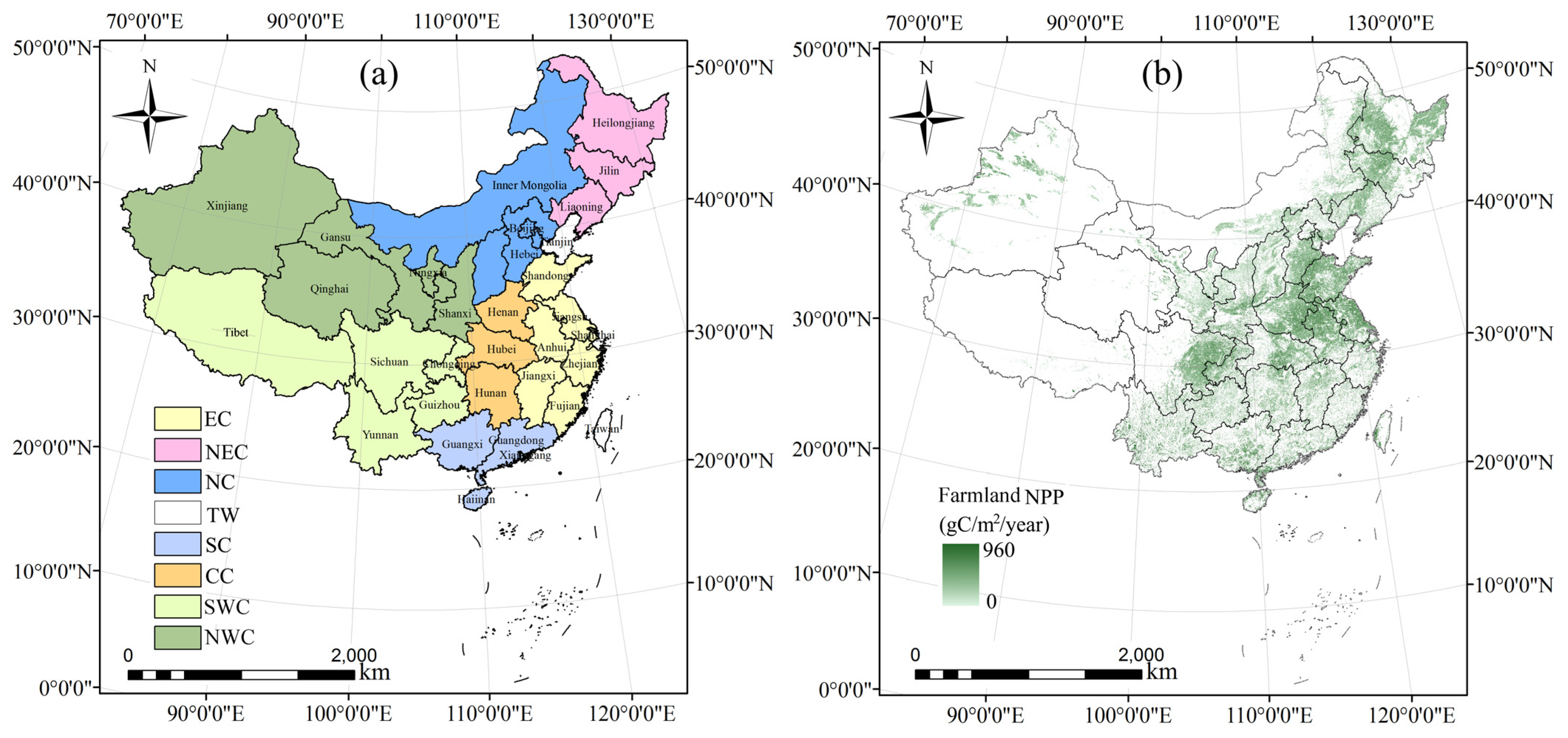
2.1. Study Area

This study covers seven geographic regions in China, including Eastern China (EC), Northeastern China (NEC), Northern China (NC), Southern China (SC), Central China (CC), Southwestern China (SWC) and Northwestern China (NWC) (Figure 1a). In terms of farmland area, the total farmland area was 1,780,670 km2 in 2020, accounting for 18.55% of China’s total area. EC had the largest farmland area at 327,686 km2, accounting for 18.51% of the total farmland area. On the provincial scale, Heilongjiang had the largest farmland area in China at 174,663 km2, accounting for 9.8% of the country’s farmland. Inner Mongolia, Sichuan and Henan followed Heilongjiang with over 100,000 km2. The total area of farmland of these four provinces approximately accounted for 30% of the total. The distribution of farmland NPP exhibited a trend of low in the northwest and high in the southeast (Figure 1b). SC and EC had the highest NPP per unit of farmland, with values greater than 700 gC/m2. The lowest NPP per unit of farmland was located in NWC, with values below 200 gC/m2. At the provincial scale, Guangxi, Guangdong and Fujian had the top three NPPs per unit of farmland, with values greater than 750 gC/m2.

2.2. Data Collections

Land-use data between 2000 and 2020 were obtained from the Resource and Environment Science and Data Center of the Chinese Academy of Science (https://www.resdc.cn/ (access on 22 October 2021)), with a spatial resolution of 30 m. These data were used to extract farmland, urban land and rural settlements in China. These land-use datasets were produced from Landsat Thematic Mapper (TM)/Enhanced Thematic Mapper (ETM) images by visual interpretation, with a classification accuracy of over 90% between 2000 and 2020 [35], demonstrating good accuracy and credibility of this database. The annual normalized difference vegetation index (NDVI) data from 2000 to 2020 were obtained from NASA’s Earth Observation System Data and Information System (https://eospso.gsfc.nasa.gov/ (access on 22 October 2021)), with a spatial resolution of 1 km. The meteorological data, including the annual average temperature, precipitation and solar radiation from 2000 to 2020, were obtained from the China Meteorological Data website (http://data.cma.cn (access on 18 October 2021)). Additionally, the boundaries of China and 34 provinces were collected from the natural earth vectors dataset of ArcGIS.10.6. The research framework of this study is shown in Figure 2.

2.3. Methods

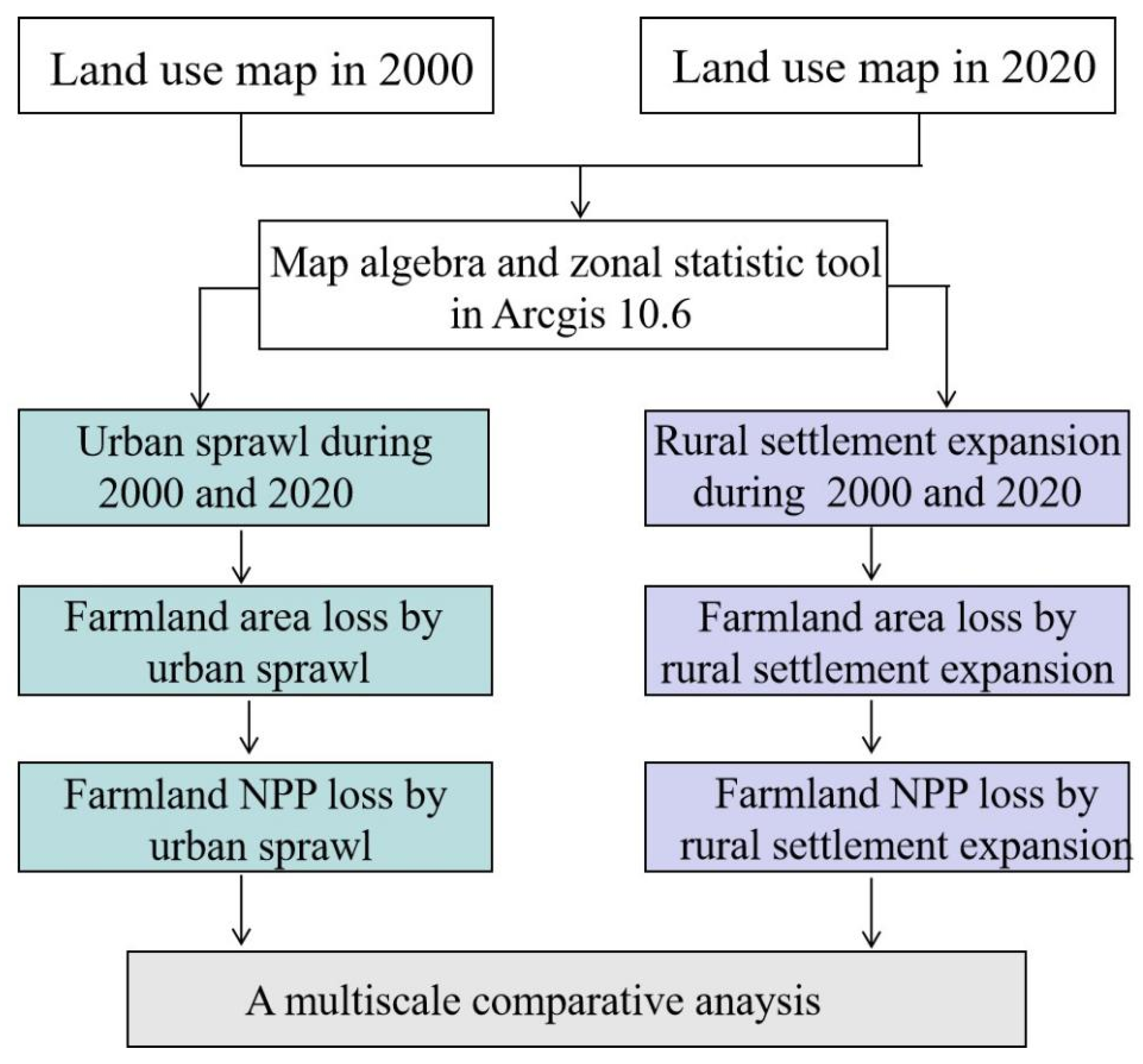
2.3.1. Quantifying Farmland Loss by Urban Sprawl or Rural Settlement Expansion

The farmland area loss caused by urban sprawl and rural settlement expansion was obtained by overlapping the land-use dataset between 2000 and 2020. Specifically, the raster unit was coded with a value of 1 representing farmland or urban land or rural settlement land and a value of 0 for land that is not the corresponding land. The “Raster calculator” tool in ArcGIS 10.6 was then used to obtain the two types of transfer maps accordingly. It is worth noting that this study also considered the conversion of urban land or rural settlement to farmland during the study period. Thus, the loss of farmland in this study refers to the net loss of farmland in a given analysis unit. The procedure can be expressed as follows:
C L l o s s = i ( C A i 2000 + C A i 2020 ) × ( U R L i 2020 U R L i 2000 )
where CLloss denotes the farmland area loss due to urban sprawl or rural settlement expansion between 2000 and 2020; CAi2000 and CAi2020 are the i th unit values of farmland data between 2000 and 2020; and URLi2000 and URLi2020 refer to the i th unit value of urban land or rural settlements between 2000 and 2020.

2.3.2. Calculation of Farmland NPP

In this study, the farmland NPP was estimated by using the CASA model, which is a satellite-based photosynthetic utilization model [44]. This model was developed according to the concept of light-use efficiency and was used to estimate NPP by using the photosynthetically active radiation absorbed by green vegetation and light-use efficiency [10,45]. Owing to its high accuracy and large-scale measurement ability, this model has been widely applied in the evaluation of NPP in China [46,47]. The specific formula is as follows:
NPP = SOL × FPAR × 0.5 × ε
where NPP is the net primary productivity, SOL is the solar radiation, FPAR is the proportion of absorbed photosynthetically active radiation, the coefficient of 0.5 denotes the ratio of incident photosynthetic effective radiation to solar radiation and ε is the light-use efficiency, which can be estimated by the following equation:
ε = T ε 1 × T ε 2 × W ε × ε max
where 1 represents the limitation of the minimum and maximum temperature, 2 represents the decreasing trend when the ambient temperature deviates from the optimal temperature, is the moisture stress coefficient and εmax is the maximum value of light-use efficiency. Based on the CASA model and the parameters provided by He et al. (2017) [10], the farmland NPP in China between 2000 and 2020 were estimated. Considering that the trend of “global greening” due to carbon dioxide enhancement may lead to statistical errors in the representation of farmland NPP [48], the long-term average of farmland NPP was used as an indicator to assess the impacts of urban sprawl or rural settlement expansion on farmland NPP (Figure 1).

2.3.3. Measuring the Impacts of Urban Sprawl or Rural Settlement Expansion on Farmland NPP

The loss of farmland NPP was estimated by overlapping farmland NPP data from 2000 to 2020 with urban land or rural settlement data. Meanwhile, the situation where farmland NPP increased due to newly added farmland converted from urban land or rural settlement was also considered. This process is expressed as follows:
C N P P l o s s = i ( C A i 2000 + C A i 2020 ) × N P P i 2000 2020 ¯ × ( U R L i 2020 U R L i 2000 )
where CNPPloss denotes the loss of farmland NPP between 2000 and 2020, and the unit is TgC (1 TgC = 1 × 10¹² gC), denoting the average value of farmland NPP per unit from 2000 to 2020; CAi2000 and CAi2020 are the i th unit values of farmland data between 2000 and 2020 and URLi2000 and URLi2020 refer to the i th unit value of urban land data or rural settlement land data between 2000 and 2020.
In this study, a 10 × 10 km grid was used to analyze the impacts of urban–rural construction on farmland at a fine scale. The Zonal Statistics tool in ArcGIS 10.6 was used to calculate the losses of farmland area and farmland NPP due to urban sprawl and rural settlement expansion for each region. Additionally, to quantitatively compare the impacts of urban sprawl and rural settlement expansion on farmland, the ratio of the farmland area loss and farmland NPP loss due to urban sprawl to the loss due to rural settlement expansion was calculated. The ratio above 1 indicates that the loss caused by urban sprawl exceeded that loss due to rural settlement expansion. In contrast, the ratio below 1 represents that the loss due to rural settlement expansion exceeded that loss due to urban sprawl. The specific formula is as follows:
R a t i o = C L U L l o s s C L R L l o s s
where Ratio denotes the comparison of the impacts of urban sprawl and rural settlement expansion on farmland, CLULloss denotes the farmland area loss, farmland NPP loss or farmland NPP loss per unit due to urban sprawl and CLRLloss denotes the farmland area loss, farmland NPP loss or farmland NPP loss per unit due to rural settlement expansion.

3. Results

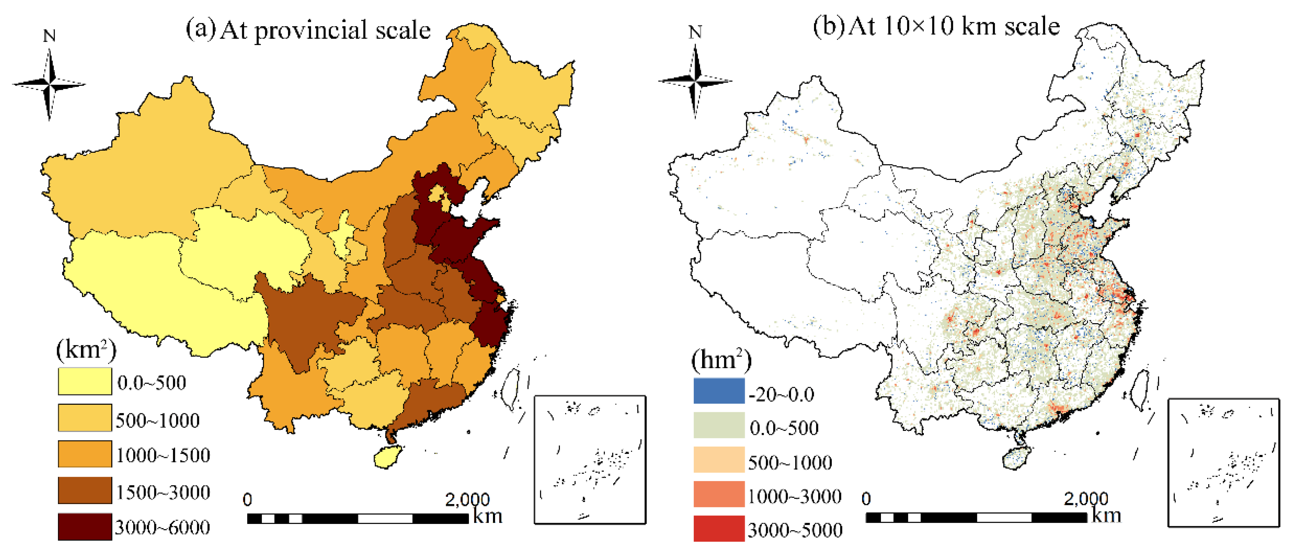
3.1. Farmland Area Loss Due to Urban Sprawl and Rural Settlement Expansion

3.1.1. Loss in Farmland Area Due to Urban Sprawl

Over the past 20 years, the amount of urban construction land in China increased from 47,059.1 km2 to 126,215.4 km2, an increase of 79,156.4 km2. Among them, a total of 49,086.6 km2 of farmland was lost in China due to urban sprawl, accounting for 62.01% of the total increasing area (Table 1). Across the seven geographical regions, the largest occupation of farmland by urban sprawl occurred in EC. Between 2000 and 2020, urban sprawl in EC resulted in a loss of 19,243.45 km2 of farmland, which was 39.21% of the total area lost through urban sprawl. The area of farmland lost by urban sprawl was the smallest in WNC, which reached 2905.60 km2 and accounted for 5.92% of the total lost area.
On the provincial level, there were obvious regional differences in the loss of farmland caused by urban sprawl. The overall loss of farmland caused by urban sprawl decreased from the east coast to the west (Figure 3a). Shandong had the largest loss of farmland area, at 5627.83 km2, which was 11.52% of the total lost area. Shandong was followed by Jiangsu, Hebei and Zhejiang, with urban sprawl causing a loss of over 3000 km2 of farmland. In contrast, the loss of farmland due to urban expansion was much lower in the western region. The losses of farmland by urban sprawl in Tibet, Qinghai and Ningxia were all less than 500 km2. At the grid scale, the loss of farmland areas was mainly concentrated in China’s provincial capital cities, with obvious clustering characteristics (Figure 3b). The loss of farmland area was more pronounced in the Yangtze River Delta and the Pearl River Delta regions. It is noteworthy that some increase in farmland occurred in discrete areas in western Xinjiang and northern Heilongjiang.

3.1.2. Loss in Farmland Area Due to Rural Settlement Expansion

Between 2000 and 2020, the amount of rural settlements in China increased by 15,102.5 km2. However, the total loss of farmland due to rural settlement expansion reached 18,006.84 km2, which was greater than the increase in the area of rural settlements (Table 1). The main reason for this phenomenon was that some rural settlements were renovated into farmland or incorporated into urban areas. At the geographical regional scale, the loss of farmland area was the largest in EC at 6260.14 km2, accounting for 34.77% of the total area lost to rural settlement expansion. NC and NEC accounted for the second and third largest losses of farmland area caused by rural settlement expansion, at 5369.29 km2 and 2097.66 km2, respectively. SC had the least amount of farmland taken up by rural settlement expansion, with a loss of only 317.13 km2 over the study period.
On the provincial scale, there were significant regional differences in the loss of farmland by rural settlement expansion, with a general downward trend from the northern coast to the southwest (Figure 4a). Hebei witnessed the largest loss of farmland due to rural settlement expansion, at 3179.26 km2, which was 17.63% of the total area due to rural settlement expansion. Jiangsu, Shandong and Liaoning all lost more than 1500 km2 of farmland due to rural settlement expansion. The total loss of farmland in these four provinces accounted for nearly half of the total lost to rural settlement expansion. In contrast, the least loss of farmland due to rural settlement expansion occurred in Tibet, at 6.41 km2. At the grid scale, farmland loss due to rural settlement expansion was more pronounced in the eastern plains, where rural population and farmland were densely distributed (Figure 4b). The loss of farmland area caused by rural settlement expansion was more pronounced in the Beijing–Tianjin–Hebei urban agglomeration, southern Jiangsu and central Henan. Meanwhile, the conversion of rural settlements to arable land increased in remote rural areas in Northern and Eastern China.

3.2. Farmland NPP Loss Due to Urban Sprawl and Rural Settlement Expansion

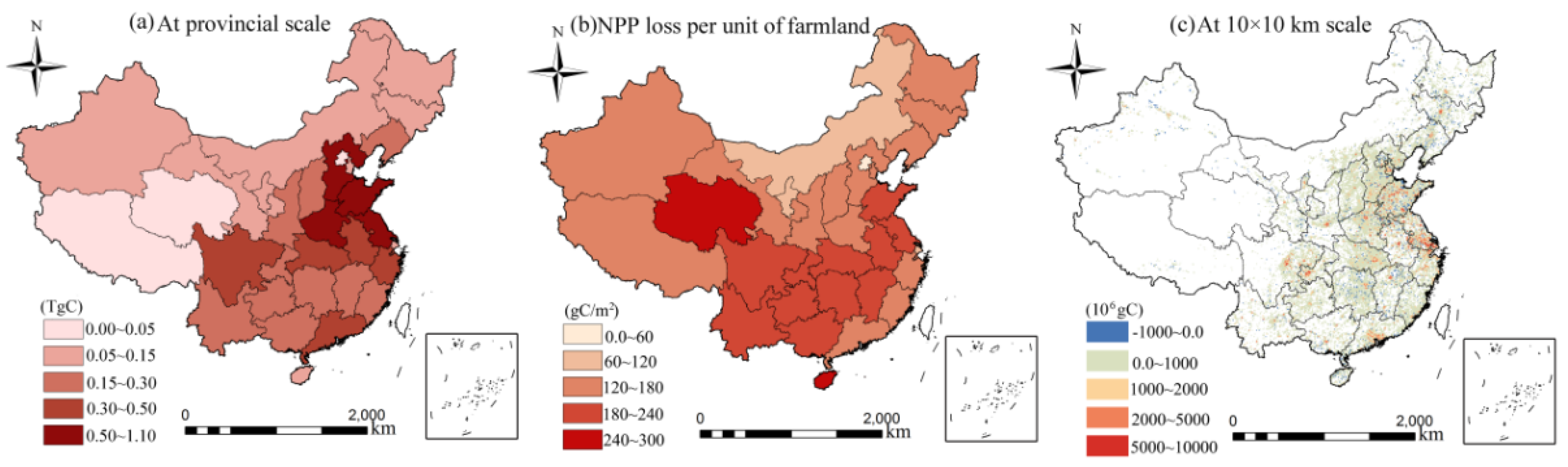
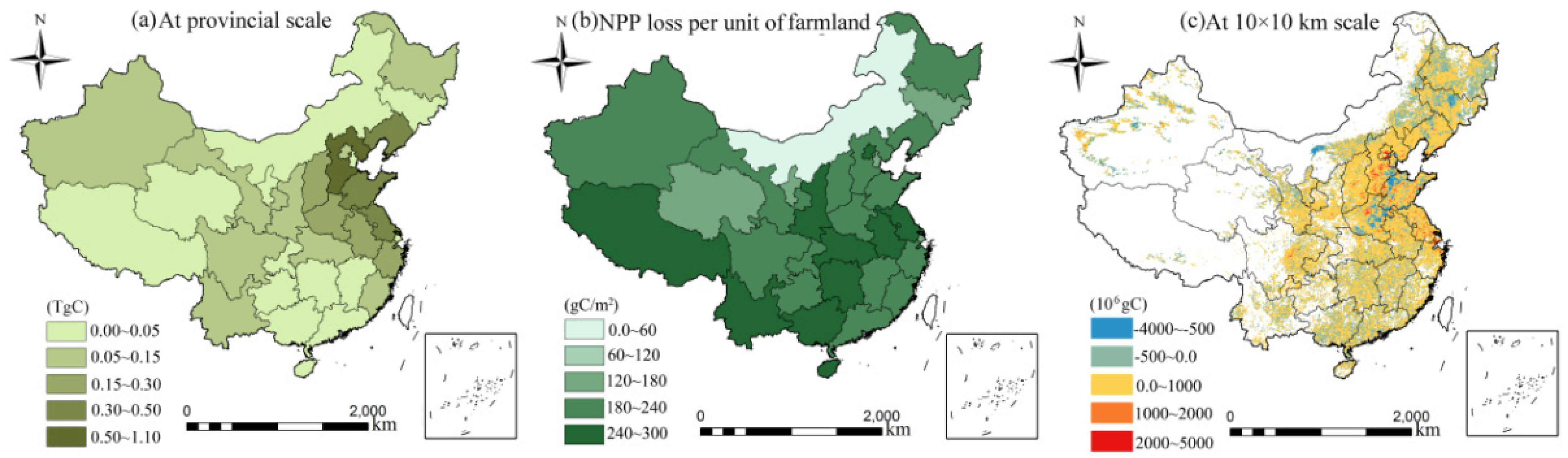
3.2.1. Loss in Farmland NPP Due to Urban Sprawl

Urban sprawl has resulted in substantial farmland NPP loss. Between 2000 and 2020, the total loss of farmland NPP due to urban sprawl was 8.34 TgC (Table 2). On the geographical regional scale, EC experienced the largest loss of farmland NPP caused by urban sprawl, totaling 3.35 TgC, accounting for 40.21% of the total loss due to urban sprawl. Farmland NPP losses caused by urban sprawl were relatively small in WNC and NEC, fewer than 0.5 TgC. From the perspective of NPP loss per unit of farmland, SC, WSC and EC ranked top three, at 198.94 gC/m2, 198.23 gC/m2 and 174.22 gC/m2, respectively.
On the provincial scale, the total loss of farmland NPP by urban sprawl showed a decreasing trend from east to west and from south to north (Figure 5a). Shandong had the largest loss of farmland NPP from urban sprawl, at 1.03 TgC, accounting for 12.47% of the total farmland NPP loss by urban sprawl. Jiangsu, Hebei and Henan followed Shandong with 0.86 TgC, 0.52 TgC and 0.51 TgC, respectively. In comparison, Tibet and Xinjiang had the smallest farmland NPP losses due to urban expansion, both exceeding 0.1 TgC. In terms of NPP loss per unit of farmland, the high-value provinces were mainly distributed in the Yangtze River Basin (Figure 5b). The largest NPP loss per unit of farmland was in Hainan (289.14 gC/m2), followed by Qinghai, Guangxi and Jiangsu, which all had NPP losses per unit of farmland exceeding 200 gC/m2. At the grid scale, high-value areas were concentrated around large cities in the Yangtze River Delta, the Pearl River Delta and the Sichuan Basin (Figure 5c). Meanwhile, some farmland NPP increased in western Xinjiang and Heilongjiang owing to an increase in farmland area.

3.2.2. Loss in Farmland NPP Due to Rural Settlement Expansion

The total loss of farmland NPP due to rural settlement expansion was 3.88 TgC (Table 2). Across the regional scale, farmland NPP losses caused by rural settlement expansion were the largest in EC, at 1.38 TgC, accounting for 35.52% of the total loss due to rural settlement expansion. SC had the least farmland NPP loss, accounting for only 2.03% of the total. The top three NPP losses per unit of farmland were WSC, SC and EC at 254.91 gC/m2, 243.24 gC/m2 and 229.92 gC/m2, respectively.
On the provincial scale, the total farmland NPP loss due to rural settlement expansion decreased from east to west (Figure 6a). The largest loss of farmland NPP was found in Hebei, with a value of 0.64 TgC, accounting for 16.4% of the total NPP loss by rural settlement expansion. Jiangsu was the second-highest-ranking province for this indicator. The least loss of farmland NPP by rural settlement expansion was in Tibet, with a value of 0.02 TgC. In terms of NPP loss per unit of farmland, its distribution pattern generally showed a decreasing trend from south to north (Figure 6b). The largest loss per unit of farmland NPP due to rural settlement expansion was in Hainan (384.12 gC/m2), while the smallest loss per unit of farmland NPP was in Inner Mongolia, at 130.61 gC/m2. At the grid scale, the areas with high values of farmland NPP loss were distributed in southern Hebei, central Henan and Jiangsu (Figure 6c). The areas where farmland NPP increased mainly occurred in northern Shandong, eastern Henan, Heilongjiang and Jilin, which were far from urbanized areas and had fertile farmland.

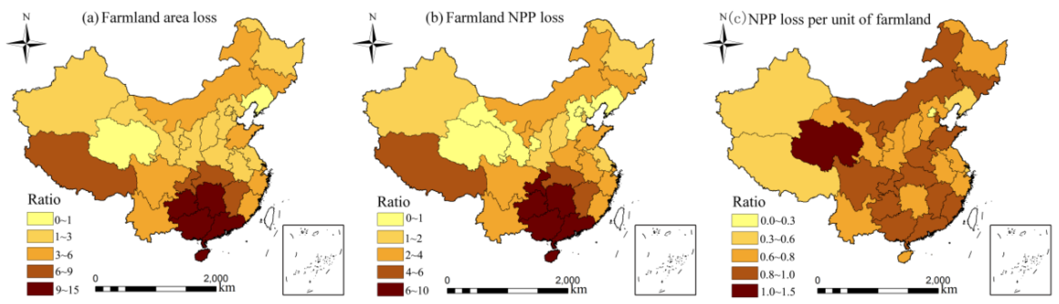
3.3. A Comparison of the Impacts of Urban Sprawl and Rural Settlement Expansion on Farmland

Both the losses of farmland area and farmland NPP due to urban sprawl far exceeded the losses caused by rural settlement expansion. The total losses of farmland area and farmland NPP caused by urban sprawl were 2.7 times and 2.2 times greater than the loss from rural settlement expansion, respectively (Table 1 and Table 2). Spatially, the areas of farmland loss due to urban sprawl were more concentrated than that by rural settlement expansion. The largest gap between the total area of farmland loss due to urban sprawl and the total loss area due to rural settlement expansion was 12,983.3 km2 in EC, while the smallest gap was 1291.1 km2 in NEC. The largest gap between the loss of farmland NPP due to urban sprawl and the total loss due to rural settlement expansion occurred in EC at 1.97 TgC. It is noteworthy that the total loss of farmland NPP due to rural settlement expansion in NC was greater than the total loss due to urban sprawl. In terms of NPP loss per unit of farmland, the losses due to rural settlement expansion were higher than the losses due to urban sprawl in all seven geographical regions, with the largest gap of 75.2 gC/m2 in NEC.
In general, both farmland area loss and farmland NPP loss due to urban sprawl exceeded the losses due to rural settlement expansion in most Chinese provinces (Figure 7a,b). The ratio of both showed a decreasing trend from south to north. The highest ratio of farmland area loss was in Hunan at 17.2, followed by Guangdong (12.2) and Hainan (10.1). In Liaoning and Qinghai, the ratio of farmland area loss was below 1, indicating that urban expansion had lower impacts on farmland area than the expansion of rural settlements. The highest ratio of farmland NPP loss was also found in Hunan at 13.3, followed by Guizhou (10.96) and Guangdong (10.41). In contrast, the impact of urban expansion on farmland NPP loss was lower than that of rural settlement expansion in some provinces in NC and NWC, such as Hebei (0.82), Qinghai (0.70) and Liaoning (0.58). In terms of the ratio of farmland NPP loss per unit due to urban sprawl to the loss due to rural settlement expansion (Figure 7c), the ratio was less than 1 in most provinces, indicating that the farmland NPP loss per unit due to urban sprawl was lower than the loss caused by rural settlement expansion. The ratio generally exhibited a distribution pattern of high in the north and south and low in the center. Qinghai had the highest ratio at 1.63, followed by Guizhou (0.93) and Jilin (0.91).

4. Discussion

4.1. Substantial Impacts of Rural Settlement Expansion on Farmland

Farmland and rural settlements are the most widely interacting landscapes in rural China and are strongly influenced by urbanization [36]. Empirical studies on the impacts of rural settlement expansion on farmland have been conducted in some regions during the process of urbanization [7,24], and such impacts were also investigated in this study. Furthermore, this study quantified the impacts of rural settlement expansion on farmland and its NPP by comparing them to the impacts of urban sprawl at the national scale, which contributes to deepening the understanding of the interactive relationships between urban–rural land-use transition and farmland protection. The results show that between 2000 and 2020, the area of farmland loss due to urban sprawl in China was 2.72 times greater than the area of farmland lost to rural settlement expansion. This finding is consistent with a recent study that indicated farmland loss due to urban expansion was 2.8 times greater than that from rural settlement expansion in China between 2000 and 2010 [7]. More importantly, the results found that the NPP loss per unit of farmland caused by urban sprawl was lower than that resulting from rural settlement expansion. Therefore, the considerable loss of farmland and its NPP due to rural settlement expansion deserves further attention.
This study revealed the spatially heterogeneous impacts of rural settlement expansion on farmland through multi-scale analysis. The results show that the greatest loss of farmland and its NPP due to rural settlement expansion mostly occurred in the Huang-Huai-Hai Plain, including Beijing, Tianjin, Hebei, Shandong, Henan and Anhui, where the impacts of urban sprawl were also observed. These areas are the major grain-producing regions of China, where farmlands are always close to rural settlements, highlighting the potential vulnerability of farmlands in rural areas to rural settlement expansion [49]. When considering the impacts of rural settlement expansion on farmland at grid scale, the results show the process of mutual conversion between rural settlements and farmland occurred simultaneously in EC, NEC and NC. This indicates that farmland compensation reclaimed by rural settlements often occurred beyond administrative boundaries themselves [18]. For example, Hebei and Jiangsu experienced large-scale loss of farmland and its NPP, while Heilongjiang and Xinjiang added much farmland, which is consistence with other studies in China [12,50]. Thus, the nationwide net loss of farmland due to rural settlement expansion is heavily dependent on large increases in farmland in some areas. This may lead to an underestimation of the impacts of rural settlement expansion on farmland.
From the perspective of NPP loss per unit of farmland, the results exhibit that the loss of NPP per unit of farmland due to rural settlement expansion in SC and EC was greater than that in other areas. This phenomenon occurs because SC has higher vegetation coverages, adequate precipitation and suitable temperature, in EC, it is mainly due to high-intensity agricultural planting to maintain better vegetation coverage [51]. Furthermore, in most provinces, the loss of NPP per unit of farmland due to rural settlement expansion was also greater than the loss caused by urban sprawl. This is related to the fact that farmland NPP surrounding cities is more vulnerable to urban expansion and high-intensity human activities [52]. In comparison, agroecosystems in rural areas are better, and farmland is less affected by low-density human activities in rural areas [53,54]. Notably, the NNP of new farmland reclaimed by rural settlements is usually lower than that of surrounding farmland, further exacerbating the loss of NPP per unit of farmland due to rural settlement expansion. This is caused by the phenomenon of “superior occupation and inferior compensation” in the requisition–compensation balance of farmland [2].
This study showed that rural settlement expansion mainly occurred in economically developed cities and major agricultural production plains. Such distribution of rural settlement expansion is in line with previous findings [55,56]. This is because during periods of urbanization and industrialization, many rural enterprises around big cities emerged and developed rapidly, occupying large amounts of fertile farmland [57]. This phenomenon occurs widely in developed coastal areas with sufficient investment and mature urban–rural industrial systems [58]. In the major agricultural production plains, numerous floating populations and agricultural transfer populations that have settled in cities have not given up rural homesteads, stimulating the reconstruction and expansion of rural settlements for improving living conditions [59,60]. This study highlights the considerable loss in farmland and its NPP due to rural settlement expansion. The results contribute to understanding the serious impacts of rural settlement expansion on farmland in China. It can also draw our attention to the loss of farmland in the process of rural transition development and urge us to adopt strict land management policies to protect farmland in rural reconstruction.

4.2. Spatial Differences in Impacts of Urban Sprawl and Rural Settlement Expansion on Farmland

The distribution patterns of total loss in farmland and its NPP due to urban sprawl and rural settlement expansion were similar, both decreasing from east to west. This is related to fact that both urban and rural land development is relevant to the increase in population size and income levels for urban and rural residents [61]. Between 2000 and 2020, large population movements to the east and rural–urban migration led to a continuous increase in urban land. Meanwhile, as a result of income improvement, the living standards of rural residents increased, leading to an increase in housing demand [60]. Consequentially, a large amount of farmland was occupied by the simultaneous expansion of urban land and rural settlements in Eastern China. According to statistics, the total population of EC increased from 364.65 million in 2000 to 423.83 million in 2020, and the disposable income of urban and rural residents increased 6.3 times and 6.7 times, respectively. As urbanization and industrialization continue to advance, the contradiction between farmland protection and urban–rural land development will further intensify.
Comparing the total loss of farmland and its NPP due to urban sprawl and rural settlement expansion, the results indicate that the impacts of rural settlement expansion on farmland in Southern China were less serve than that in the north by comparing the impacts of urban sprawl. The differences arise from the comprehensive influences of geographic environment and socioeconomic factors [62,63]. Southern China is dominated by low mountains and hills, and rural settlements are scattered and small in scale [64]. The expansion of rural settlements is limited by geography and transportation [65]. In this condition, more populations prefer to settle in cities, driven by urbanization. As a result, the impacts of urban expansion on farmland were greater than that of rural settlements in these regions. In contrast, NC, EC and NEC have large plains where populations and settlements are clustered. The dramatic increase in population size and economic level led to rapid expansion of urban land and rural settlements, resulting in the occupation of large amounts of farmland in the neighboring settlements [66]. More seriously, the expansion of rural settlements in some regions, such as Hebei, Liaoning and Gansu, has resulted in a greater loss of farmland than the loss by urban expansion (Figure 7b).

4.3. Implications for China’s Farmland Protection and Sustainable Urban–Rural Land Management

Farmland not only provides available space for urban and rural construction but also provides the material basis for urban–rural integrated development. Farmland protection has become one of the primary factors influencing sustainable regional social economy development. In order to control the increasingly urban and rural construction land and farmland loss, the Chinese government has innovatively proposed the Requisition–Compensation Balance of Farmland Policy and the Integrated Consolidation and Allocation of Rural–Urban Construction Land Policy [67]. The former was first proposed in 1999 and requires new farmland to compensate for the loss of farmland due to urban expansion with an equal amount and quality of land. The other aims to achieve equilibrium in the supply of construction land by balancing the increase in urban land with the decrease in rural settlements [59]. These two policies imply a dynamic connection between urban–rural land use and farmland protection and has alleviated the pressure on farmland protection to some extent [68]. However, this study showed that from 2000 to 2020, the net loss of farmland due to rural settlement expansion was still widespread. This is related to local governments being keen to land acquisition for urbanization, and the capacity of these policies may be degraded. Lack of market access to rural land and unreasonable rural planning also causes a lot of farmlands to be occupied by newly rural settlements [38], indicating that these farmland protection policies need to be rethought and improved from the perspective of urban–rural integrated development.
Rural-to-urban population is an important driver of land-use changes; thus, coordinating human–land interactive relationships in urban and rural systems is the key to reducing their serious impact on farmland [69]. It is recommended that an effective human–land linkage mechanism and a unified urban–rural construction land market be established to improve the Integrated Consolidation and Allocation of Rural–Urban Construction Land and Requisition–Compensation Balance of Farmland policies. In rural areas with rural population outflows, newly increased rural settlements must be strictly monitored, and priority should be given to land remediation of idle rural settlements [70]. New construction land quotas can be transferred to the immigration areas for urban construction through urban–rural construction land markets. The proceeds from the construction land quotas are then used to feed landless farmers and reclaim farmland with the same quality. Village planning is the basic base for rural land and space development and protection activities. It is urgent for local governments to positively formulate and implement village planning, comprehensively taking farmland use, industrial development, residential layout and ecological protection into account. Meanwhile, village planning needs to fully consider the future development trend of villages to avoid the waste of lots of infrastructure and the inefficient use of homesteads; forward-looking village planning is of great significance to farmland protection and rural revitalization [41].
In cities with an influx of rural population, land consolidation in urban villages should to be carried out orderly, and the land urbanization should transform from spatial sprawling to fully utilizing the inner urban land. Meanwhile, local governments should accelerate the process of population urbanization by lowering the requirements for people settlement, increasing employment opportunities and improving social security systems for the inflowing population [71]. In recent years, the Chinese government has attempted to implement the policies of Integrated Consolidation and Allocation of Rural–Urban Construction Land and Requisition–Compensation Balance of Farmland at the national scale. The expansion of the scope of the policies’ implementation can help break through regional resource endowment constraints and further optimize the allocation of land resources across the country. Thus, more efforts, including regulatory systems and compensation mechanisms, are needed to safeguard rural interests and improve these two innovative policies.

4.4. Limitations and Research Prospects

This study explored and compared the impacts of urban sprawl and rural settlement expansion on farmland at multiple scales over the past 20 years and found that rural settlement expansion has considerable impacts on farmland and its NPP. However, there are still some limitations. Firstly, this study only used land-use data for specific time points (i.e., between 2000 and 2020) in China, time series of land use data are needed to reveal the dynamic process of farmland loss. Secondly, the farmland NPP used in this study represents the nature attribute of farmland, but it cannot fully reflect the actual grain production, which is comprehensively influenced by farming systems, crop types, agricultural technology and socioeconomic demands. Thirdly, the impacts of other land-use processes, such as converting farmland to forest or waterbody are not considered in this study, which may lead to underestimation of the serious impacts of land-use changes on farmland. In the future, the correlation between farmland NPP and actual grain production should be quantified to accurately analyze the impact of land-use changes on grain production and implications for regional food security.

5. Conclusions

In the context of rapid urbanization, urban sprawl and rural settlement expansion in China jointly resulted in the great loss of farmland. This study used land-use maps and spatial analysis methods to explore and compare the impacts of urban sprawl and rural settlement expansion on farmland and its NPP in China between 2000 and 2020. The results could help to deepen the understanding of the relationship between urban–rural construction and farmland protection in developing countries.
The results show that the total loss of farmland and its NPP caused by urban sprawl were 49,086.6 km2 and 8.34 TgC during the study period, which were 2.73 times and 2.15 times higher than the losses caused by rural settlement expansion, respectively. Meanwhile, the greater impacts of both urban sprawl and rural settlement expansion on farmland mainly occurred in EC and CC. Furthermore, the ratios of the loss of farmland and its NPP due to urban sprawl to that due to rural settlement expansion generally tended to decrease from south to north. Noteworthily, the NPP loss per unit of farmland due to rural settlement expansion was higher than that resulting from urban expansion in most provinces. Based on the above results, an effective human–land linkage mechanism and a unified urban–rural construction land market were suggested to promote the coordination of urban–rural construction and farmland protection.
Significant land-use changes and land management have occurred in China over the past four decades. The interactive relationships between urban–rural construction and farmland protection dominate the process of urban–rural integrated development. Thus, it is of great significance to deeply explore and compare the impacts of urban and rural construction on farmland and its NPP and to improve farmland protection policies from the perspective of urban–rural integrated development. In particular, the significant impacts of rural settlement expansion on farmland need to be considered in farmland protection policies and initiatives. The results of this study can provide important references for the overall planning of urban–rural land use and sustainable socioeconomic development in practical application.

Author Contributions

Conceptualization, C.Z. and S.Y.; methodology, L.Y.; software, J.F.; validation, Q.X. and Y.L.; formal analysis, L.S.; investigation, S.H.; writing—review and editing, C.Z. All authors have read and agreed to the published version of the manuscript.

Funding

This research was funded by the National Natural Science Foundation of China, grant number 41871181; National Natural Science Foundation of China, grant number 42001201; Zhejiang Provincial Social Science Federation Research Project, grant number 2022N111; and Zhejiang Province Philosophy and Social Science Planning Project, grant number 22NDQN287YB.

Institutional Review Board Statement

Not applicable.

Data Availability Statement

Not applicable.

Conflicts of Interest

The authors declare no conflict of interest.

References

  1. FAO (Food and Agriculture Organization of the United Nations). Food Security Statistics; FAO: Rome, Italy, 2016. [Google Scholar]
  2. Liu, L.; Liu, Z.; Gong, J.; Wang, L.; Hu, Y. Quantifying the amount, heterogeneity, and pattern of farmland: Implications for China’s requisition-compensation balance of farmland policy. Land Use Policy 2019, 81, 256–266. [Google Scholar] [CrossRef]
  3. Seto, K.C.; Ramankutty, N. Hidden linkages between urbanization and food systems. Science 2016, 352, 943–945. [Google Scholar] [CrossRef] [PubMed]
  4. Van Vliet, J.; Eitelberg, D.A.; Verburg, P.H. A global analysis of land take in cropland areas and production displacement from urbanization. Glob. Environ. Change 2017, 43, 107–115. [Google Scholar] [CrossRef]
  5. Huang, Q.; Liu, Z.; He, C.; Gou, S.; Bai, Y.; Wang, Y. The occupation of cropland by global urban expansion from 1992 to 2016 and its implications. Environ. Res. Lett. 2020, 15, 084037. [Google Scholar] [CrossRef] [Green Version]
  6. Pandey, B.; Seto, K.C. Urbanization and agricultural land loss in India: Comparing satellite estimates with census data. J. Environ. Manag. 2015, 148, 53–66. [Google Scholar] [CrossRef]
  7. Ju, H.; Zhang, Z.; Zhao, X.; Wang, X.; Wu, W.; Yi, L.; Wen, Q.; Liu, F.; Xu, J.; Hu, S.; et al. The changing patterns of cropland conversion to built-up land in China from 1987 to 2010. J. Geogr. Sci. 2018, 28, 1595–1610. [Google Scholar] [CrossRef] [Green Version]
  8. Brown, L.R. Who will feed China? Futurist 1996, 30, 14–18. [Google Scholar]
  9. Kong, X. China must protect high-quality arable land. Nature 2014, 506, 7. [Google Scholar] [CrossRef] [Green Version]
  10. He, C.; Liu, Z.; Xu, M.; Ma, Q.; Dou, Y. Urban expansion brought stress to food security in China: Evidence from decreased cropland net primary productivity. Sci. Total Environ. 2017, 576, 660–670. [Google Scholar] [CrossRef]
  11. Zhou, Y.; Li, X.; Liu, Y. Cultivated land protection and rational use in China. Land Use Policy 2021, 106, 105454. [Google Scholar] [CrossRef]
  12. Yuan, C.; Zhang, D.; Liu, L.; Ye, J. Regional characteristics and spatial-temporal distribution of cultivated land change in China during 2009–2018. Trans. CSAE 2021, 37, 267–278. [Google Scholar]
  13. Foley, J.A.; DeFries, R.; Asner, G.P.; Barford, C.; Bonan, G.; Carpenter, S.R.; Chapin, F.S.; Coe, M.T.; Daily, G.C.; Gibbs, H.K. Global consequences of land use. Science 2005, 309, 570–574. [Google Scholar] [CrossRef] [PubMed]
  14. Deng, X.; Huang, J.; Rozelle, S.; Zhang, J.; Li, Z. Impact of urbanization on cropland changes in China. Land Use Policy 2015, 45, 1–7. [Google Scholar] [CrossRef]
  15. Nkeki, F. Spatio-temporal analysis of land use transition and urban growth characterization in Benin metropolitan region, Nigeria Remote Sens. Appl. Soc. Environ. 2016, 4, 119–137. [Google Scholar]
  16. d’Amour, B.; Reitsma, F.; Baiocchi, G.; Barthel, S.; Guneralp, B.; Erb, K.H.; Haberl, H.; Creutzig, F.; Seto, K.C. Future urban land expansion and implications for global croplands. Proc. Natl. Acad. Sci. USA 2017, 114, 8939–8944. [Google Scholar] [CrossRef] [Green Version]
  17. Tang, J.; Di, L. Past and future trajectories of farmland loss due to rapid urbanization using Landsat imagery and the markov-CA model: A case study of Delhi, India. Remote Sens. 2019, 11, 180. [Google Scholar] [CrossRef] [Green Version]
  18. Yang, B.; Ke, X.; van Vliet, J.; Yu, Q.; Zhou, T.; Verburg, P. Impact of cropland displacement on the potential crop production in China: A multi-scale analysis. Reg. Environ. Change 2020, 20, 97. [Google Scholar] [CrossRef]
  19. Narducci, J.; Quintas-Soriano, C.; Castro, A.; Som-Castellano, R.; Brandt, J.S. Implications of urban growth and farmland loss for ecosystem services in the western United States. Land Use Policy 2019, 86, 1–11. [Google Scholar] [CrossRef]
  20. Skakun, S.; Justice, C.O.; Kussul, N.; Shelestov, A.; Lavreniuk, M. Satellite data reveal cropland losses in South-Eastern Ukraine under military conflict. Front. Earth Sci. 2019, 7, 305. [Google Scholar] [CrossRef] [Green Version]
  21. Ullah, K.M.; Uddin, K. The relationships between economic growth and cropland changes in Bangladesh: An evidence based on annual land cover data. Environ. Chall. 2021, 5, 100252. [Google Scholar] [CrossRef]
  22. Skinner, M.W.; Kuhn, R.G.; Joseph, A.E. Agricultural land protection in China: A case study of local governance in Zhejiang Province. Land Use Policy 2001, 18, 329–340. [Google Scholar] [CrossRef]
  23. Chen, Z.; Wang, Q.; Huang, X. Can land market development suppress illegal land use in China? Habitat Int. 2015, 49, 403–412. [Google Scholar] [CrossRef]
  24. Skog, K.L.; Steinnes, M. How do centrality, population growth and urban sprawl impact farmland conversion in Norway? Land Use Policy 2016, 59, 185–196. [Google Scholar] [CrossRef]
  25. UN DESA. World Urbanization Prospects: The 2018 Revision (ST/ESA/SER.A/420); United Nations: New York, NY, USA, 2019.
  26. Lian, H.; Li, H.; Ko, K. Market-led transactions and illegal land use: Evidence from China. Land Use Policy 2019, 84, 12–20. [Google Scholar] [CrossRef]
  27. Conrad, C.; Rudloff, M.; Abdullaev, I.; Thiel, M.; Low, F.; Lamers, J.P.A. Measuring rural settlement expansion in Uzbekistan using remote sensing to support spatial planning. Appl. Geogr. 2015, 62, 29–43. [Google Scholar] [CrossRef]
  28. Gosch, M.; Parente, L.; dos Santos, C.; Mesquita, V.; Ferreira, L. Landsat-based assessment of the quantitative and qualitative dynamics of the pasture areas in rural settlements in the Cerrado biome, Brazil. Appl. Geogr. 2021, 136, 102585. [Google Scholar] [CrossRef]
  29. Li, H.; Song, W. Expansion of rural settlements on high-quality arable land in Tongzhou District in Beijing. China. Sustainability 2019, 11, 5153. [Google Scholar] [CrossRef] [Green Version]
  30. Chen, Z.; Li, Y.; Liu, Y.; Liu, X. Does rural residential land expansion pattern lead to different impacts on eco-environment? A case study of loess hilly and gully region, China. Habitat Int. 2021, 117, 102436. [Google Scholar]
  31. Liu, Y.; Li, Y. Revitalize the world’s countryside. Nature 2017, 548, 275–277. [Google Scholar] [CrossRef] [Green Version]
  32. Li, Y.; Chen, C.; Wang, Y.; Liu, Y. Urban–rural transformation and farmland conversion in China: The application of the environmental Kuznets curve. J. Rural. Stud. 2014, 36, 311–317. [Google Scholar] [CrossRef]
  33. Li, Y.; Li, Y.; Westlund, H.; Liu, Y. Urban–rural transformation in relation to cultivated land conversion in China: Implications for optimizing land use and balanced regional development. Land Use Policy 2015, 47, 218–224. [Google Scholar] [CrossRef]
  34. Song, W.; Li, H. Spatial pattern evolution of rural settlements from 1961 to 2030 in Tongzhou District, China. Land Use Policy 2020, 99, 105044. [Google Scholar] [CrossRef]
  35. Liu, J.; Ning, J.; Kuang, W.; Xu, X.; Zhang, S.; Yan, C.; Li, R.; Wu, S.; Hu, Y.; Du, G.; et al. Spatio-temporal patterns and characteristics of land-use change in China during 2010–2015. Acta Geogr. Sin. 2018, 73, 789–802. [Google Scholar]
  36. Liu, Y.; Wang, J.; Long, H. Analysis of arable land loss and its impact on rural sustainability in southern Jiangsu Province of China. J. Environ. Manag. 2010, 91, 646–653. [Google Scholar] [CrossRef]
  37. Li, H.; Yuan, Y.; Zhang, X.; Li, Z.; Wang, Y.; Hu, X. Evolution and transformation mechanism of the spatial structure of rural settlements from the perspective of long-term economic and social change: A case study of the Sunan region, China. J. Rural. Stud. 2019, in press. [Google Scholar] [CrossRef]
  38. Zhu, C.; Zhang, X.; Wang, K.; Yuan, S.; Yang, L.; Skitmore, M. Urban–rural construction land transition and its coupling relationship with population flow in China’s urban agglomeration region. Cities 2020, 101, 102701. [Google Scholar] [CrossRef]
  39. Qu, Y.; Jiang, G.; Ma, W.; Li, Z. How does the rural settlement transition contribute to shaping sustainable rural development? Evidence from Shandong, China. J. Rural Stud. 2021, 82, 279–293. [Google Scholar]
  40. Zhu, S.; Kong, X.; Jiang, P. Identification of the human-land relationship involved in the urbanization of rural settlements in Wuhan city circle, China. J. Rural Stud. 2020, 77, 75–83. [Google Scholar] [CrossRef]
  41. Li, T.; Long, H.; Wang, Y.; Tu, S. The spatio-temporal characteristics and consolidation potential of rural housing land in farming area of the Huang-Huai-Hai Plain: The cases of five villages in Yucheng city. J. Nat. Resour. 2020, 35, 2241–2253. [Google Scholar] [CrossRef]
  42. Liu, Y.; Luo, T.; Liu, Q.; Kong, X.; Li, J.; Tan, R. A comparative analysis of urban and rural construction land use change and driving forces: Implications for urban-rural coordination development in Wuhan, Central China. Habitat Int. 2015, 47, 113–125. [Google Scholar] [CrossRef]
  43. Liu, T.; Shi, Q.; Wang, Y.; Yang, Y. Urban-rural development and occupation of cultivated land in China: Trends, geography, and drivers. Geogr. Res. 2018, 37, 1609–1623. [Google Scholar]
  44. Potter, C.S.; Randerson, J.T.; Field, C.B.; Matson, P.A.; Vitousek, P.M.; Mooney, H.A.; Klooster, S.A. Terrestrial ecosystem production: A process model based on global satellite and surface data. Glob. Biogeochem. Cycles 1993, 7, 811–841. [Google Scholar] [CrossRef]
  45. Piao, S.; Fang, J.; Zhou, L.; Zhu, B.; Tan, K.; Tao, S. Changes in vegetation net primary productivity from 1982 to 1999 in China. Glob. Biogeochem. Cycles 2005, 19, GB2027. [Google Scholar] [CrossRef] [Green Version]
  46. Fang, J.; Piao, S.; Field, C.B.; Pan, Y.; Guo, Q.; Zhou, L.; Peng, C.; Tao, S. Increasing net primary production in China from 1982 to 1999. Front. Ecol. Environ. 2003, 1, 293–297. [Google Scholar] [CrossRef]
  47. Yan, Y.; Liu, X.; Wang, F.; Li, X.; Ou, P.; Wen, Y.; Liang, X. Assessing the impacts of urban sprawl on net primary productivity using fusion of Landsat and MODIS data. Sci. Total Environ. 2018, 613–614, 1417–1429. [Google Scholar] [CrossRef]
  48. Chen, C.; Park, T.; Wang, X.; Piao, S.; Xu, B.; Chaturvedi, R.K.; Fuchs, R.; Brovkin, V.; Ciais, P.; Fensholt, R.; et al. China and India lead in greening of the world through land-use management. Nat. Sustain. 2019, 2, 122–129. [Google Scholar] [CrossRef] [PubMed]
  49. Xie, J.; Jin, X.; Lin, Y.; Chen, Y.; Yang, X.; Bai, Q.; Zhou, Y. Quantitative estimation and spatial reconstruction of urban and rural construction land in Jiangsu Province, 1820–1985. J. Geogr. Sci. 2017, 27, 1185–1208. [Google Scholar] [CrossRef]
  50. Gao, X.; Cheng, W.; Wang, N.; Liu, Q.; Ma, T.; Chen, Y.; Zhou, C. Spatio-temporal distribution and transformation of cropland in geomorphologic regions of China during 1990–2015. J. Geogr. Sci. 2020, 29, 180–196. [Google Scholar] [CrossRef] [Green Version]
  51. Pan, J.; Xu, B. Modeling spatial distribution of potential vegetation NPP in China. Chin. J. Ecol. 2020, 39, 1001–1012. [Google Scholar]
  52. Liu, X.; Pei, F.; Wen, Y.; Li, X.; Liu, Z. Global urban expansion offsets climate-driven increases in terrestrial net primary productivity. Nat. Commun. 2019, 10, 5558. [Google Scholar] [CrossRef] [Green Version]
  53. Li, W.; Li, X.; Tan, M.; Wang, Y. Influences of population pressure change on vegetation greenness in China’s mountainous areas. Ecol. Evol. 2017, 7, 9041–9053. [Google Scholar] [CrossRef] [PubMed]
  54. Zhang, X.; Brandt, M.; Tong, X.; Ciais, P.; Yue, Y.; Xiao, X.; Zhang, W.; Wang, K.; Fensholt, R. A large but transient carbon sink from urbanization and rural depopulation in China. Nat. Sustain. 2022, 5, 321–328. [Google Scholar] [CrossRef]
  55. Tian, G.; Qiao, Z.; Zhang, Y. The investigation of relationship between rural settlement density, size, spatial distribution and its geophysical parameters of China using Landsat TM images. Ecol. Model. 2012, 231, 25–36. [Google Scholar] [CrossRef]
  56. Liu, W.; Yang, C.; Liu, Y.; Wei, C.; Yang, X. Impacts of concentrated rural resettlement policy on rural restructuring in upland areas: A case study of Qiantang Town in Chongqing, China. Land Use Policy 2018, 77, 732–744. [Google Scholar] [CrossRef]
  57. Ma, W.; Jiang, G.; Wang, D.; Li, W.; Guo, H.; Zheng, Q. Rural settlements transition (RST) in a suburban area of metropolis: Internal structure perspectives. Sci. Total Environ. 2018, 615, 672–680. [Google Scholar] [CrossRef]
  58. Liu, Y. Rural transformation development and new countryside construction in eastern coastal area of China. Acta Geogr. Sin. 2007, 6, 563–570. [Google Scholar]
  59. Long, H. Land Use and Rural Transformation Development in China; Science Press: Beijing, China, 2012. [Google Scholar]
  60. Liu, T.; Liu, H.; Qi, Y. Construction land expansion and cropland protection in urbanizing China: Insights from national land surveys, 1996–2006. Habitat Int. 2015, 46, 13–22. [Google Scholar] [CrossRef]
  61. Song, W.; Chen, B.; Zhang, Y. Land-use change and socio-economic driving forces of rural settlement in China from 1996 to 2005. Chin. Geogr. Sci. 2014, 24, 511–524. [Google Scholar] [CrossRef] [Green Version]
  62. Li, G.; Jiang, C.; Du, J.; Jia, Y.; Bai, J. Spatial differentiation characteristics of internal ecological land structure in rural settlements and its response to natural and socio-economic conditions in the Central Plains, China. Sci. Total Environ. 2020, 709, 135932. [Google Scholar] [CrossRef]
  63. Liu, Y. Introduction to land use and rural sustainability in China. Land Use Policy 2018, 74, 1–4. [Google Scholar] [CrossRef]
  64. Hu, Q.; Wang, C. Quality evaluation and division of regional types of rural human settlements in China. Habitat Int. 2020, 105, 102278. [Google Scholar] [CrossRef]
  65. Chen, Z.; Liu, Y.; Feng, W.; Li, Y.; Li, L. Study on spatial tropism distribution of rural settlements in the Loess Hilly and Gully Region based on natural factors and traffic accessibility. J. Rural Stud. 2022, 93, 441–448. [Google Scholar] [CrossRef]
  66. Ke, W.; Zhu, Y.; Chen, C.; Guy, J.; Lin, L.; Lin, J. Spatio-temporal evolution of migration in China from 1995 to 2015. Acta Geogr. Sin. 2022, 77, 411–425. [Google Scholar]
  67. Zuo, L.; Zhang, Z.; Carlson, K.; MacDonald, G.K.; Brauman, K.A.; Liu, Y.; Zhang, W.; Zhang, H.; Wu, W.; Zhao, X.; et al. Progress towards sustainable intensification in China challenged by land-use change. Nat. Sustain. 2018, 1, 304–313. [Google Scholar] [CrossRef]
  68. Long, H.; Li, Y.; Liu, Y.; Woods, M.; Zou, J. Accelerated restructuring in rural China fueled by ‘increasing vs. decreasing balance’ land-use policy for dealing with hollowed villages. Land Use Policy 2012, 29, 11–22. [Google Scholar] [CrossRef]
  69. Boudet, F.; MacDonald, G.K.; Robinson, B.E.; Samberg, L.H. Rural-urban connectivity and agricultural land management across the Global South. Glob. Environ. Change 2019, 60, 101982. [Google Scholar] [CrossRef]
  70. Kong, X.; Liu, Y.; Jiang, P.; Tian, Y.; Zou, Y. A novel framework for rural homestead land transfer under collective ownership in China. Land Use Policy 2018, 78, 138–146. [Google Scholar] [CrossRef]
  71. Wang, X.; Hui, E.; Choguill, C.; Jia, S. The new urbanization policy in China: Which way forward? Habitat Int. 2015, 47, 279–284. [Google Scholar] [CrossRef]
Figure 1. Geographical division (a) and farmland distribution (b) in China (2020).
Land 11 01738 g001
Figure 2. Research framework of the study.
Land 11 01738 g002
Figure 3. Spatial distribution of the loss of farmland area due to urban land sprawl from 2000 to 2020.
Land 11 01738 g003
Figure 4. Spatial distribution of the loss of farmland area due to rural settlement expansion from 2000 to 2020.
Land 11 01738 g004
Figure 5. Spatial distribution of the loss of farmland NPP due to urban sprawl from 2000 to 2020.
Land 11 01738 g005
Figure 6. Spatial distribution of the loss of farmland NPP due to rural settlement expansion from 2000 to 2020.
Land 11 01738 g006
Figure 7. Ratios of farmland loss due to urban sprawl to the loss due to rural settlement expansion from 2000 to 2020.
Land 11 01738 g007
Table 1. Farmland area loss due to urban land sprawl and rural settlement expansion between 2000 and 2020.
RegionsImpacts of Urban Land SprawlImpacts of Rural Settlement Expansion
Farmland Area Loss (km2)RatioFarmland Area Loss (km2)Ratio
EC19,243.4539.21%6260.1434.77%
NEC3388.836.90%2097.6611.65%
NC7775.3915.84%5369.2929.82%
SC3651.767.44%317.131.76%
CC6629.8213.51%1430.627.94%
WSC5491.7711.19%1018.425.66%
WNC2905.605.92%1513.588.41%
Total49,086.6118,006.84
Table 2. Farmland NPP loss due to urban sprawl and rural settlement expansion between 2000 and 2020.
Impacts of Urban Land SprawlImpacts of Rural Settlement Expansion
Farmland NPP Loss (TgC)NPP Loss per Unit of Farmland (gC/m2)RatioFarmland NPP Loss (TgC)NPP Loss per Unit of Farmland (gC/m2)Ratio
EC3.35174.2240.21%1.38229.9435.49%
NEC0.48140.555.71%0.45215.7011.66%
NC1.05134.7912.57%1.09203.1728.12%
SC0.73198.948.71%0.08243.181.99%
CC1.24187.3414.90%0.30211.407.79%
WSC1.09198.2313.06%0.26254.896.69%
WNC0.40138.904.84%0.32211.868.26%
Total8.34 3.88
Publisher’s Note: MDPI stays neutral with regard to jurisdictional claims in published maps and institutional affiliations.

