Article

Mapping Uncounted Anthropogenic Fill Flows: Environmental Impact and Mitigation

1
Faculty of Systems Engineering, Wakayama University, Wakayama 640-8510, Japan
2
Plus GIS, Wakayama 649-6246, Japan
3
Faculty of Life Sciences, Kyoto Sangyo University, Kyoto 603-8555, Japan
*
Author to whom correspondence should be addressed.
Land 2022, 11(11), 1959; https://doi.org/10.3390/land11111959
Submission received: 1 October 2022 / Revised: 27 October 2022 / Accepted: 31 October 2022 / Published: 2 November 2022
(This article belongs to the Special Issue Land: 10th Anniversary)

Abstract

:
Fill material flows created by land development earthworks are anthropogenic agents that generate massive energy use from their heavy loads. However, formal quantification of these flows has been neglected. We use Osaka Prefecture in Japan as a case study to quantify fill flows and associated CO2 emissions. We collected data on fill flows, including fill generation and acceptance. We mapped these publicly uncounted fill flows and calculated the CO2 emissions from the associated energy use. We also simulated a scenario in which optimized shortest-distance matching is achieved between fill generators and acceptors. We estimated the current fill flows based on distance and weight and broke down the total by type of site and activity. We compared our estimates of current fill flows with estimates from our matching simulation and found the simulation could achieve an 8448 km reduction in flow length and a 5724 t-CO2 reduction in emissions associated with transportation. We discussed the implications of flexible matching, especially in different construction sectors, and the importance of continuous, spatially geo-referenced monitoring of these fill flows toward further environmental impact mitigation. The approach presented here could apply to assessing environmental loads arising from landform changes in other cities and lead to development of a new regional- and global-scale fill material science in the Anthropocene.

1. Introduction

Land-use changes, especially those due to urbanization, have brought about large environmental impacts on a global scale [1]. Among these, residential development spreading toward urban–rural interfaces has been one of the main land-use change patterns associated with deterioration of former agricultural lands [2], agroecosystems [3], and natural ecosystems [4]. Many studies describe unidirectional land-use changes, such as residential development on land that was formerly used for agriculture [5,6,7,8], yet only a few studies identify offsite soil sources (for housing basements) as land-use alternations that are inherently connected with other sites through earth material flows [9,10,11]. In short, residential developments were built through use of earthworks as anthropogenic landform changes [12], which provide massive flows of soil, crushed rock, and other fill material, including both inflows and outflows at a development area [13]. One case is Bangkok, which lies in a delta situated on a continental landform. Here, the flat alluvial land, offsite sand excavations far upstream (for high-rise buildings), and nearby soil excavation (for basements of low-rise housing) on former rice fields that were originally deltaic wetlands are important land alterations that occur because of the strong demand for housing development in the delta area at the urban fringe of a large metro area [14]. A contrasting case is Metro Manila, which sits amidst lowlands situated on an insular landform. Here, the close distance between the alluvial plain and the surrounding hilly and mountainous uplands means that the basement materials for the low-lying housing—consisting mainly of soil, crushed rock, and construction debris—can be generated from nearby areas. Flow of these materials is mainly achieved through matching agreements between individual fill material suppliers on the one hand and housing developers or other users of fill material on the other hand [15].
Sometimes, these coupled onsite and offsite land-use changes, together with their vertical landform transformations, provide benefits to ecosystem services, such as providing new habitats for organisms, especially birds [16], but, in many cases, they have negative environmental impacts depending on the geological setting. These adverse effects include land cracks from unapproved undersea sand mining in continental, deltaic Bangkok [17], riverbank instability from unsustainable sand mining in the lower Mekong River [18], utilization of construction waste debris for low-lying landfill without any checks against environmental standards in insular Metro Manila [15], and various types of landslide and debris flows in Japan due to the massive soil fill (Figure 1) remaining from land-cut development in nearby or remote areas [19]. Human-induced landslide disasters in Japan are projected to increase in conjunction with more frequent extreme rainfall events of increasing intensity caused by global warming [20]. In fact, a strong debris flow in Atami City, Japan on 3 July 2021 killed 26 people residing along a steep stream with a massive unapproved fill at the headwater point, which drew public and scientific attention to the issue of inappropriate fill [21]. After this incident, national, prefectural, and individual municipal governments began to recheck the spatial distribution of possibly dangerous fill sites. However, storing of old city planning maps and other important mapping archives in paper format has become an obstacle to conducting such a survey in Japan—an indication of the lower status in Japan of digitized information resources that were created in the past but hold future value [22,23].
Nevertheless, disasters induced by unapproved cut–fill are not new, especially in the insular landforms of Japan. Since the 1960s, alluvial plains in Japan have mostly been developed in tandem with urbanization and economic development, and hilly and mountainous areas at the urban fringe have drawn intensive focus as sites for cut–fill residential development. A few scientific groups and individuals noted the large potential for adverse environmental impact during the 1970s [24] and 1980s [25], but, in most cases, the development was still carried out because economic development was the highest priority at the time. Moreover, the businesses handling such developments with massive cut–fill-induced soil flows were sometimes unlicensed, which made it difficult to engage with them. The result is that few people understood the whole environmental picture of landform transformation related to soil flows. In many cases, these soil flows were not counted in public statistics because of the secretive nature of the matching between fill suppliers and accepters [26]. Moreover, depending on the socioeconomic and geological settings, fill can be used as a natural resource for sale, for example, to make deeper fill basements in flood- and tsunami-prone areas [27]. This undercounting increases the difficulty of understanding flow structures. Hence, quantification of these structures to help assess environmental impact has been difficult and only been conducted in a few preliminary studies [28,29,30] and for projects of national importance, such as creating an artificial island for Kansai International Airport [31]. Furthermore, during this intensive development period, there was almost no concept of open-source data, and quantification tools, including digital statistical data and geographic information system (GIS), were not yet developed, making it almost impossible to address these massive soil problems. In response to this situation, the central government tried to promote appropriate reuse of fill from earthworks with the goal of reducing total fill material and eliminating issues with unapproved or illegal fill over the long-term [32]. However, the lack of quantitative and scientific data, as described above, together with inadequate reuse incentives, has caused the material reuse rate (slightly less than 80% in a 2018 survey) to be below the national target for fill, unlike the higher rates for other building materials, such as concrete, steel, wood, and other materials [33].
Although Japan has experienced frequent economic recessions since the 1990s, similar land developments, especially new residential development in hilly suburban areas, have still been occurring in conjunction with revitalization of old urban centers [34], and cut–fill-induced soil hazards are now drawing attention as a result of increased public environmental awareness [19,21,35]. Thus, landform transformations from massive soil flows require immediate study so that these environmental impacts can be quantified and future landslide and debris flows can be prevented. To accomplish this, we have to address these three quantitative questions: (1) how large are the fill material flows produced by human geomorphic agents compared to flows produced by natural landform processes? (2) How large is the energy use associated with this fill material flow, especially the portion of consumed energy not included in statistical counts due to non-monetary supply–demand matching, compared to the existing counts derived from public statistics based on monetary transactions? (3) How can we gauge this material flow and the associated energy use based on the spatial extent of this unmeasured environmental impact?
To answer these research questions, we studied Osaka Prefecture, an urban center in the Kansai region of west central Japan and the third largest prefecture by population (approximately 8.8 million people) as of 2021 [36]. Its population density is about 4641 people/km2, which is the second densest after Tokyo (6410 people/km2), reflecting the densely developed built-up areas in the plain and surrounding hilly and mountainous areas. The spatiotemporal distribution of large-scale cut–fill land developments makes this a suitable study area. We focused on two major sets of sites: (1) a large representative reclamation site (Chikiri Island) on public lands in Osaka Bay and (2) 16 private inland fill sites that were required to submit records in accordance with the Osaka Prefectural Government’s special ordinance for soil flow records. Using the data from the prefecture, we mapped the main soil flows. We then calculated the total soil volume and weight to estimate CO2 emissions from the associated energy use. Next, we compared our estimates to the natural geomorphic erosion rate in this area and to publicly available statistics for energy use and waste generation in the construction sector. We also conducted scenario analysis for simulations that minimize environmental impact through optimized matching between suppliers and accepters. We use our results to discuss possible energy use reduction and its importance for reduction in greenhouse gas emissions and disaster risk prevention in the Anthropocene context. Finally, we discuss the importance of controlling this neglected earth soil flow to mitigate environmental impacts originating from land use (including its horizontal and vertical components as well as its onsite and offsite components) and elaborate on disaster-resilient land-use and landscape planning at multiple scales as a step toward creating and maintaining human living spaces in a sustainable ecosystem.

2. Materials and Methods
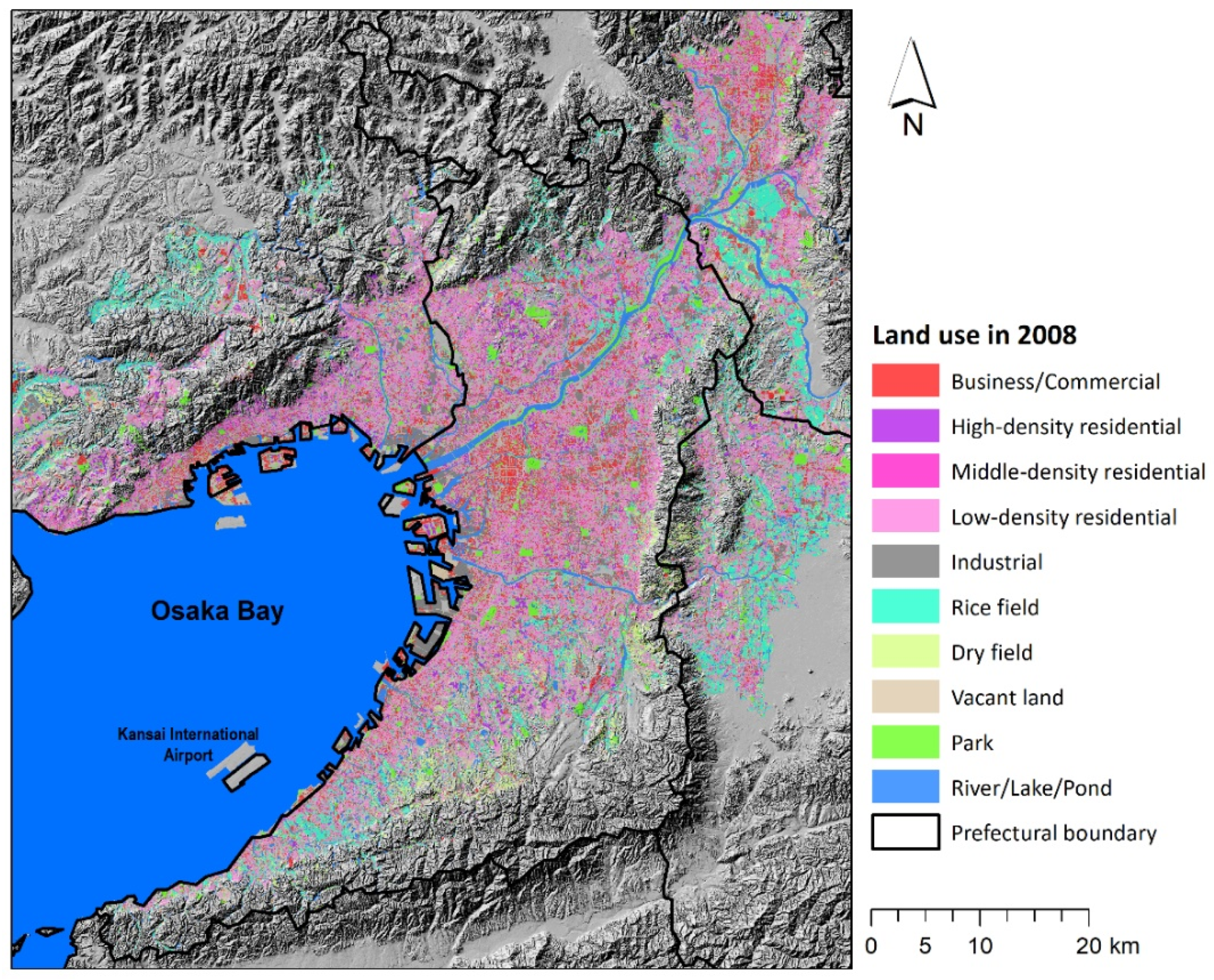
2.1. Study Area

This study focuses on Osaka Prefecture in west central Japan, which has an area of 1899 km2 and a population of 8.8 million in 2021 [36]. Its boundary corresponds closely with mountain ridges on the north, east, and south, while the western part faces Osaka Bay. Its land-use pattern clearly shows a densely developed urban center in the west central section facing Osaka Bay and suburban residential areas among mixed urban–rural land uses along an urbanization gradient from the lower plain to the hills and mountains (Figure 2). The urban center was mostly developed before World War II and soon thereafter as a large industrial city [37]. After the war, hilly suburban areas with relatively soft alluvial-based sediments were developed, especially during the 1950s and 1960s, using some cut–fill land development [38]. From the 1970s until now, development has taken place in the rim areas of the hills and mountains and in the mountainous areas themselves. This new development includes large cut–fill residential development [39], which has led to expansion in anthropogenic landforms (Figure 1).
Unlike the Tokyo Metropolitan Area, Osaka Prefecture has a relatively distinct natural landform boundary comprising mountain ridges and the bay area (Figure 2). We thus assume that fill material flows occur in large part within prefectural spaces from the mountains to the sea, although there may be other inflows and outflows across the boundary. These conditions make the area a suitable one to help us understand fill material flows.

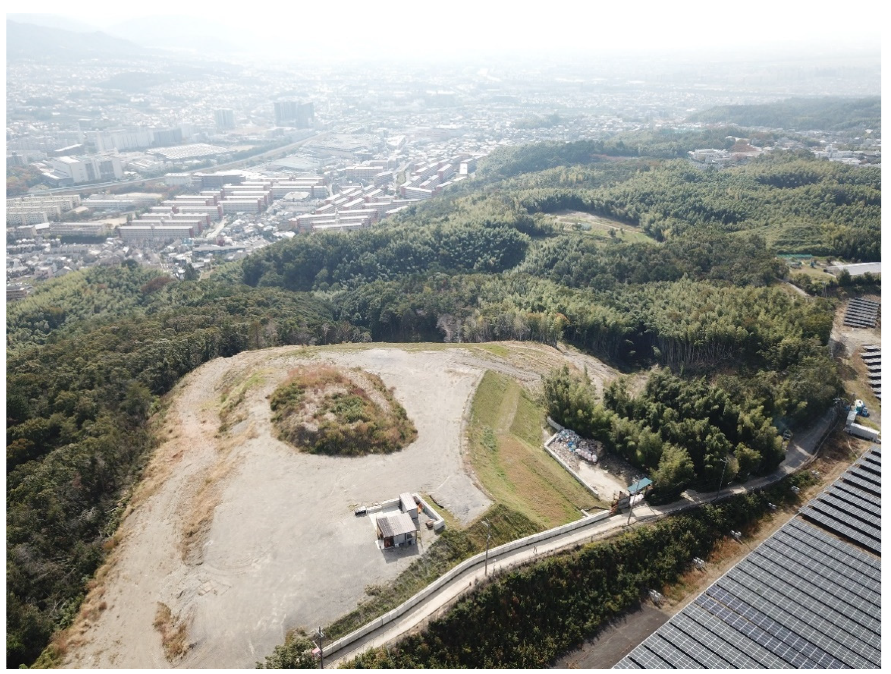
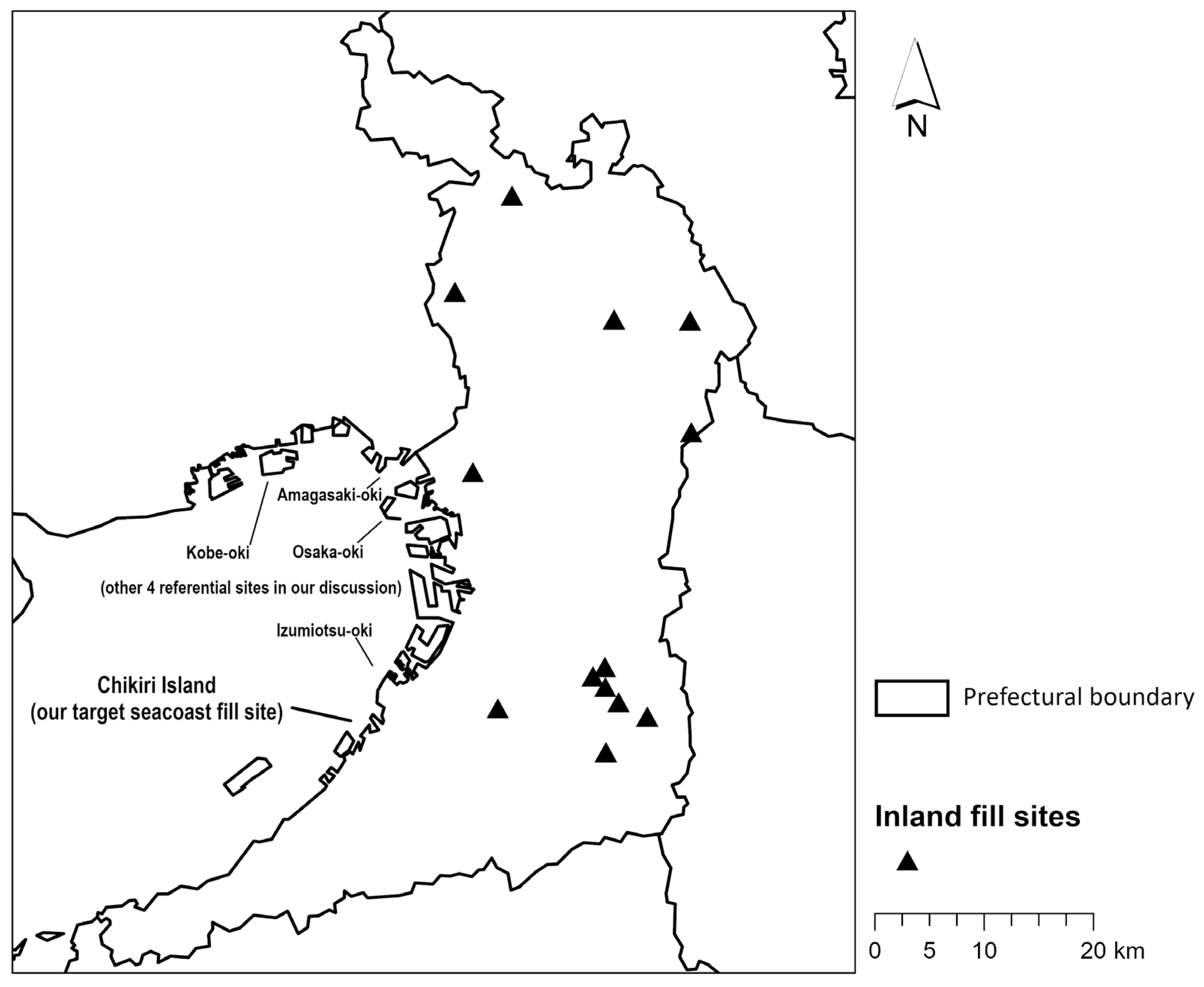
2.2. Target Fill Sites

First, we collected site information on fill generation and acceptance by using the internet, governmental office visits, and field investigations supported by Google Earth and Google Maps [41], GSI maps [42], and other online map sources, as well as paper records [43,44]. We then concluded that we would use the following two reliable sources for our fill flow analysis: (1) one large coastal land reclamation site, Chikiri Island [45], and (2) 16 inland private fill acceptance sites monitored with records submitted in accordance with Osaka Prefectural Ordinance No. 2014-177 on appropriate fill management [46]. The sites are shown in Figure 3 (map) and Figure 1 and Figure 4 (photos).
Chikiri Island, which kindly gave us permission to use detailed fill information, is one of the largest operating landfill sites accepting fill soils generated by public earthworks. It is also the newest site in operation in the longstanding history of land reclamation in Osaka Bay [47]. There is another large coastal fill acceptance island next to Chikiri Island as well as three other acceptance sites in Osaka Bay (Figure 3), all of which are publicly managed by the Osaka Bay Regional Offshore Environmental Improvement Center [48]. Due to privacy issues, the center could not grant us access to the entire dataset. Instead, they did grant us permission to use data already published on their website, which is confined to yearly cumulative fill volume for each site. We were able to use this dataset for volume comparison in our discussion. Nevertheless, we believe detailed fill data from Chikiri Island, along with supporting data from these four “referential sites”, are representative of Osaka Bay’s historical land reclamation trends regarding rate and volume of coastal fill acceptance [47]. After corresponding with appropriate personnel and submitting an official request in writing, we obtained the data on fill transported over land in csv format and data on dredged soil transported by ship in the form of scanned PDFs of paper records.
Inland private fill flows are generally the most difficult flow type to acquire knowledge of due to privacy issues. However, in accordance with the ordinance, the Osaka Prefectural Government kindly gave us permission to use their monitored fill records, including source land address, acceptance land address, fill quality according to the government standard [49], and fill soil volumes in m3. Because the ordinance only applies to sites larger than 3000 m2 [46], we cannot consider the smaller individual private fill sites and the activity thereon. These records are only accessible in paper format. According to the officials in charge of data acquisition for this ordinance, the sites can be considered as being representative of inland private fill sites.

2.3. Data Digitization and Environmental Load Mapping

Original data for Chikiri Island consist of eight csv files for fill transported over land and one PDF file for dredged fills transported by ship. Each csv file covers a single year between 2014 and 2021, and each entry (line) represents one daily fill volume observation per address and includes information on date of fill acceptance, weight in tons, and place of fill generation in Japanese address format. In total, the eight csv files include 42,054 entries. The PDF file for fill transported by ship has a similar structure to the csv files, except that it states the amount of fill in volume (m3) instead of weight. We attribute this difference to the characteristics of ship transportation that make it difficult to calculate weight, unlike a land site where trucks have their contents weighed at the entrance point.
We then prepared the data for each fill generation site using ESRI ArcGIS Pro version 2.6.3 and verified the data by referring to several online maps, including Google Maps [41], GSI maps [42], and Mapion [50]. First, we separated the entries between fill generation addresses that can be clearly identified as land parcels on a spatial scale (represented by a point) and those having vague addresses, such as sub-district names and river section names (represented by a polygon). We then added a fill weight attribute to each instance of vector data to store monthly fill generation data in order to facilitate comparisons with other seacoast and inland fill sites. This attribution process was supported by use of ESRI ArcGIS Pro version 2.6.3 (Esri, Redlands, CA, USA) and Python version 3.7.2 (Python Software Foundation, Wilmington, DE, USA). In the case of PDF data for shipped fills, due to the relatively small number of entries (44 in total), we manually added a weight attribute to each instance of vector data. In this process, we used a specific gravity of 1.6 to derive weight from cubic volume in accordance with the government standard [33]. At this stage, after confirming that there were no extreme spatial differences between polygons, we converted all polygon data into point data and represented them spatially by their barycenters for use in mapping, energy calculation, and simulations.
Data for the inland private fills came in paper format and totaled 1023 pages with some redactions to protect privacy under the ordinance rules. These input data were processed manually using Microsoft 365 Excel (Microsoft Corporation, Redmond, WA, USA). We then converted the land address data from Japanese text into latitude and longitude by using an address matching program [51]. Next, we prepared point data and added monthly attributes for fill volume and fill weight (in tons), which we calculated from the volume by using a specific gravity of 1.8 based on an existing report [33], and also plotted the location of acceptance sites for transported fill. For some points, we conducted supporting field investigations to validate the actual land-use situation in consideration of legal privacy concerns using a drone, digital camera, or smartphone.
We mapped these data as line data between the fill source and destination. Flows between the same start and end points (but with different dates) were mapped as just one line for clear visualization. We also plotted the relationship between weight and distance (lengths of the generated lines) using Microsoft 365 Excel and SPSS version 23 (SPSS Inc., Chicago, IL, USA). Next, we calculated CO2 emissions from energy use under the current fill flow patterns. We assumed that only a negligible amount of inland-type fill soil came from a different stockyard than the one assumed in the line drawing and supported this assumption with a detailed investigation of the generation site addresses against the paper records as well as by using web-based satellite and aerial images [41,42] and our interviews with the officials. Based on this assumption, we set our energy use calculation boundary on the fill generation side and applied the emissions intensity factor (0.00565 kg-CO2/kg [52,53]) to calculate energy used in fill generation. To calculate energy used in fill transportation, we simply used the spatial distance between the two points and applied an emissions intensity factor (0.341 kg-CO2/t·km [52,53]) to calculate CO2 emissions from energy used in fill transport. We chose not to use road network distances because of the high density of roads within Osaka Prefecture as almost more than 10 km/km2 [54]. As for the dredging fill materials transported by ship to Chikiri Island, we used emissions intensity factors for volume (23.6 kg-CO2/m3 [55]) to calculate CO2 emissions from dredging and for distance (0.0342 kg-CO2/t·km [56,57]) to calculate CO2 units for transportation by ship. We then multiplied these factors by their respective flow kilometrage and weight and summed this value over all flows to obtain the total environmental load in kg-CO2 for our mapped fill flows. We also mapped the monthly fill flows with fill weight attributes as a time-series map animation, which indicated that there are no large spatially uneven distributions among the months from 2014 to 2021, our period of data coverage for both sets of sites. We thus decided to conduct our simulation using the sum of these fill flows. Based on our current fill flow mapping results, we decided to exclude the shipped dredging fills to Chikiri Island from our matching simulation because the effects are minor and the CO2 emission units are different due to the different transportation mode.

2.4. Senario Simulation toward Environmental Impact Mitigation

We conducted a scenario simulation with the help of ESRI ArcGIS Pro version 2.6.3 and Python version 3.7.2. First, we searched online and referred to similar sample Python code [58] to develop our own code for this simulation. (The applied Python programming code for this study is available as Code S1.) Our simulation conditions are as follows: (1) each fill acceptance site (both Chikiri Island and inland sites) must accept fill from the nearest site. (2) If the site becomes full (under its current capacity), the second nearest fill acceptance site becomes the candidate site. If only a certain proportion of the fill (of each current generator site) can be accepted at the nearest fill acceptance site, the remaining fill is assigned to the second nearest fill site. (3) This process is continued until all fills are accepted in a fill acceptance site. In this way, the total distance of fill material flows is minimized. (4) Finally, we mapped this optimized fill supply–demand matching result and calculated CO2 emissions in the same way as described for the current fill flow in Section 2.3 and compared this mapping with the current fill to gain perspective on the feasibility of possible environmental impact mitigation. After completing this simulation, in order to discuss the feasibility of this matching simulation, we collected government reports about current efforts to reduce environmental impact and fill-related disaster risks by developing a matching system. We also discussed this by phone with the official in charge of this issue at the Ministry of Land, Infrastructure, Transport and Tourism [59]. The interview covered recent trends in site matching, actual bottlenecks, possible directions for improvements, and the potential for developing a matching system for use in environmental impact mitigation.

3. Results

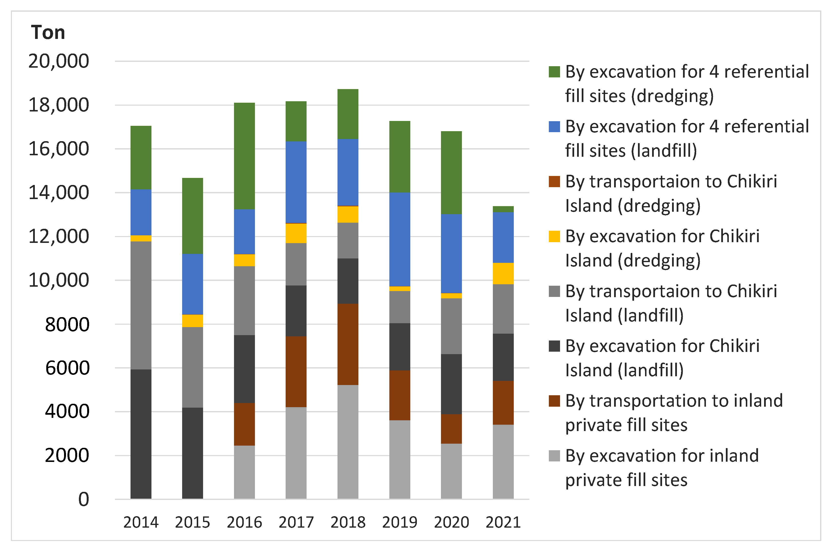
3.1. Current Fill Flows and Their Energy Use

Figure 5 shows the current total (2014–2021) fill flows in our investigated fill sites in Osaka Prefecture. A monthly fill flow map is also available in Animation S1. Figure 6 shows distributions of the entire set of fill flows by weight (t) and distance (km). Our results show a notable pattern of spatial separation of the current fill material flows to inland and seacoast fill sites (Figure 5). Focusing only on distance, we find that inland private fill sites (total of 943 flows) average 13.07 km, land transportation to Chikiri Island (total of 4353 flows) 11.18 km, and shipped dredging fill to Chikiri Island (total of 37 flows) 9.02 km. Moreover, for both Chikiri Island and the private fill sites, fill flows greater than 40 km are rare, and most fill flows travel around 10 km (Figure 6). We also find that inland private fill sites accept relatively heavy fills from a near distance, whereas the seacoast fill site accepts heavy fills from a remote distance (Figure 6), which shows consistency with spatial fill flow patterns (Figure 5). This result is clearly supported by the distribution of fill weights across distance ranges (Figure 7). Chikiri Island accepts fill from a wide geographic range, especially lighter fills in any distance range, as well as relatively heavy fills from the over-30 km range. In the case of inland private fill sites, the fill weights in any distance range are limited to those near the mean.
We summarized the fill weights and fill flow kilometrages by site and year (Figure 8) and estimated CO2 emissions by fill excavation and transportation activities (Figure 9) in our study sites together with the four referential seacoast fill sites (shown in Figure 3). From these analyses, we calculated that current fill flows have a total kilometrage of 7668 (annual average, excludes the four referential sites), with 79% from the large seacoast fill site, 20% from the inland private fill sites, and the remaining 1% from dredging fill shipped to the seacoast site. The annual average total fill weights are 1,059,019 t, composed of 51% from the seacoast fill site, 45% from the inland private fill sites, and 4% from dredging. The annual average total CO2 emissions from fill flows are 10,964 t, 58% from excavation of fill materials and 42% from transportation.
We also analyzed annual fluctuations, but the data on fill transportation date can sometimes have greater variability (up to several months), especially at the inland private fill sites. This results in an uneven annual trend, particularly because of the absence of some inland fill site records in 2014 and 2015, but it was also affected by the implementation of the fill material ordinance starting on 1 July 2015. Despite the timing of this implementation, several inland fill sites had continual fill acceptance transactions from specific places. Because of this, we consolidated the previous year’s fill acceptance records into the submitted records under this ordinance. Nevertheless, most of the data on inland fill sites come after the fill ordinance implementation and show an uneven annual trend among fill weights and transportation distances (Figure 8) and associated CO2 emissions (Figure 9).
The total fill weight of the four referential seacoast fill sites (5,750,549 t between 2014 and 2021) is comparable to that of Chikiri Island (4,667,678 t between 2014 and 2021), although the annual ratio between the two fluctuates between 0.5 and 2.5. An interim report from the central government (based on interviews with local construction contractors) on construction material and recycling in 2018 [33] provides a figure of 416,600 m3, or 749,880 t, as the final annual unrecyclable landfill volume in Osaka Prefecture. This figure is also compatible with an annual landfill average of 1,302,278 t for the sum of Chikiri Island and the four referential sites. Moreover, the final landfill amount in Hyogo Prefecture, which borders Osaka on the west and includes two of the four referential sites, was 1,281,900 m3, or 2,307,420 t of final landfill in 2018 [33]. This also supports our fill flow estimations once the volume figures are appropriately rounded.

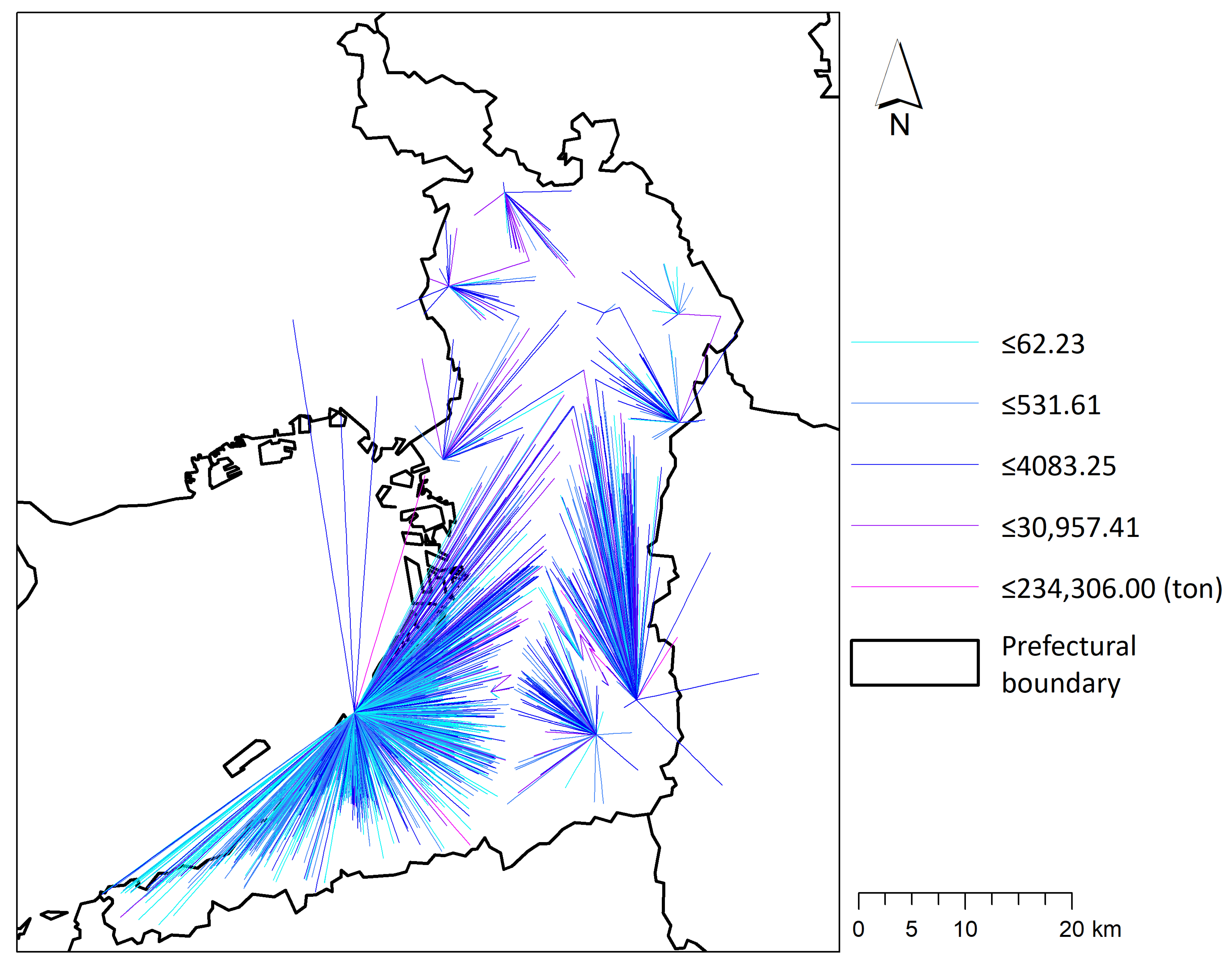
3.2. Environmental Impact Mitigation through Shortest-Distance Matching Simulation

A comparison of our shortest-distance matching simulation results (Figure 10) with the current material fill flows (Figure 5) for spatial patterns shows that fill flows in the simulation are more equally distributed spatially across our study area. The total current fill flow kilometrage of 61,016 km (Figure 5) becomes 52,568 km in the simulation (Figure 10), a reduction of 8448 km. We also calculated the total CO2 emissions from fill transportation under the simulation as 31,283 t using the same calculation method as for the current fill flows (37,007 t). Therefore, using the matching simulation brought about a CO2 reduction of 5724 t. This reduction is roughly comparable to the average annual CO2 emissions from transportation (4626 t). The implications and magnitude of these values are discussed in Section 4.2 on environmental impact mitigation.

4. Discussion

4.1. Significance of the Fill Material Flows in Geomorphic Amount and Energy Use

We first discuss the implications of our visualized fill material flows with respect to evidence of humankind’s large geomorphic agency. A previous study estimates the natural river denudation rate in this area at 22 m3/km2/year [60]. By comparison, after calculating the total fill volume generated from Osaka Prefecture between 2014 and 2021 (2,113,595 m3 for inland private fill sites, 2,425,720 m3 for landfill at Chikiri Island, and 188,364 m3 for dredging at Chikiri Island) and then dividing by the area of Osaka Prefecture (1899 km2), our estimate of anthropogenic fill flows produced a much greater value of 311.2 m3/km2/year [36]. This comparison clearly indicates the much larger power of human beings as geomorphic agents in the current era (i.e., the Anthropocene) compared to the natural erosion process. This outcome was mainly achieved by using massive amounts of fossil-fuel-based energy (Figure 9) and has great environmental impacts.
In a rural area in the same region (central Japan) where cut–fill orchard agricultural land is the predominant land use, the value has been estimated as 375 m3/km2/year [61]. At first glance, the geomorphic scale of our study’s cut–fill urban development seems comparable to that of the rural area; however, we should note that the fill flows in our study only cover a recent eight-year period and that data limitations prevented us from including all the fill material flows in our area. For instance, a previous study estimates an annual regional rate of artificial removal of earth at 5000 m3/km2/year within a 50 km radius of Osaka between 1960 and 1979 [25], when intensive residential development in hilly areas occurred during a period of rapid urbanization and economic development [39]. Given the presence of the four referential seacoast fill sites (Figure 3) and other accumulations of small fill material flows whose small scale removes them from the reporting obligation under the Ordinance, our study does not underestimate the impact of fill flows and their ability to change the landform.
As for the relationship between kilometrage and fill weights, we found some different tendencies between the inland private fill sites and coastal Chikiri Island. The longer average distance of fill flows to inland fill sites (13.07 km) compared to Chikiri Island (11.18 km) could be influenced by the urbanization gradient from the Osaka Bay seacoast area toward the surrounding hilly and mountainous areas (Figure 2). These hilly and mountainous areas, where the inland private fill sites are mostly located (Figure 2 and Figure 3), have less land allotted to urban and suburban residential land use, which is most likely a result of land availability and the necessity of keeping a certain amount of distance from denser areas to avoid environmental conflicts [35]. Because of this, spatial movement of fill flows within these areas is inevitably longer. Moreover, if we focus on the over-30 km range (Figure 7), Chikiri Island has heavier fill values compared with the other distance ranges ending at 10, 20, and 30 km at the island, and its fill weights are also comparable to those at every distance range at the inland private fill sites. The association of longer distance with heavy fill weights at Chikiri Island may indicate the convenience of having a large fill acceptance capacity at one site. One explanation is that it could be more convenient for fill generators to plan the direction their fill goes to than at the inland private fills, which are spread among 16 different sites (Figure 3 and Figure 5). For large earthworks involving public works in particular, the fill tends to go to Chikiri Island due to its large capacity and convenience. Moreover, the Chikiri Island site is better able to handle inflexible and difficult initial planning. These factors were verified in our phone interview with officials (see Section 4.2 for more detail).
Next, we discuss the scale of energy use and corresponding CO2 emissions. The average annual CO2 emissions from energy use generated by the fill flows in our study are 10,964 t-CO2. By comparison, public statistics (mostly calculated from monetary transactions and a CO2 emissions intensity factor) [62] show that the annual total CO2 emissions in Osaka Prefecture in 2019 were 42,840,000 t, of which the waste generation and management sector accounts for 1,610,000 t. Another research paper [63] estimates that CO2 emissions from all civil engineering works in Japan in 2004 were 3,827,000 t, among which earthworks accounted for 47,000 t, and all of Osaka Prefecture’s civil engineering works accounted for around 140,000 t. Applying the earthworks proportion of the total to the Osaka Prefecture result yields estimated CO2 emissions created by earthworks in Osaka Prefecture of around 1700 t-CO2 in 2004. These numbers indicate that our estimated amount of CO2 from fill flows may be a reasonable estimate for the civil engineering sector in Osaka Prefecture, which accounts for the amounts not counted in public statistics. Furthermore, if we take our comparison to the total CO2 emissions in Osaka Prefecture a step further and limit it to the waste generation and management sector, we come up with a ratio as small as less than 1%.
However, this result does not mean that the sector can be neglected regarding energy use. Indeed, our CO2-based energy estimate for fill material flows has the shortfall that it cannot include all flows or the direct and indirect energy usage associated with the excluded flows. The impact from energy generation onsite and remotely connected land use is also neglected owing to data limitations and a lack of a cumulative longer-term dataset for fill materials, thereby causing underestimation of the environmental impact from fill flow. Figure 9 provides one example of this underestimation problem: the four referential seacoast fill sites cannot include CO2 emissions from fill transportation because access to the data was not granted. In this figure, transportation and excavation in Chikiri Island have almost the same magnitude, so we can imagine that the same magnitude can be adapted to the similar four referential seacoast fill sites, which would result in much larger estimates of total CO2 emissions in the study area.
To tackle these underestimation problems, we suggest that future research integrate an analysis of GIS-based landform changes using the existing DEM dataset as well as data on past DEM construction acquired by digitizing old detailed maps, similar to what was carried out in Singapore [11]. We are already in the initial stage of applying this approach to our area [30] and believe it can facilitate evaluation of cumulative cut-and-fill volume and its associated long-term changes, which can be integrated into our fill flow volume and energy use analyses. We could also include a footprint analysis [64] to extend our fill flow calculation boundary, along with further model construction to connect the approaches to these DEM-based landform and land-use change and footprint analyses in detailed spatial scales. Moreover, the issues related to fill material include landslide disaster risk in our daily living space (Figure 1), which illustrates the importance of continuing the fill flow analysis in this study for use in monitoring high-risk landform changes. We thus view our fill material flow analysis as having multiple dimensions across earthworks, material flows, energy use, disaster risk prevention, and creating livable daily human living spaces in rural and regional ecosystems. As a key factor to building networks and connections between these different disciplines, it is vital to address these fill flows continually.

4.2. Possible Environmental Impact Mitigation by Supply–Demand Matching and Expected Obstacles

Our simulation theoretically achieves a total reduction in fill flow distance of 8448 km and a CO2 reduction of 5724 t through optimized shortest-distance matching. These numbers come close to the annual averages (2014–2021) of 7668 km and 4626 t, respectively. As discussed, in terms of energy use in the Osaka area, 4626 t-CO2 is not large in comparison with the annual emissions of individual industrial sectors, including the waste generation and management sector. In human terms, a reduction of 5724 t-CO2 corresponds to the annual CO2 emissions of 2160 households in Osaka Prefecture at a CO2 emissions rate of 2.65 t/household [65].
Regarding the reliability and feasibility of our simulation, we had anticipated several possible obstacles against shortest-distance matching based on the interim government report [33] and our phone interviews with officials. The first major obstacle is the timing of the matching. As shown in Animation S1, even at a time scale as short as one month, we can see a time lag between each fill flow, even though the overall spatial distribution of flows in Osaka Prefecture is relatively even. Governmental officials whom we interviewed also pointed out this timing mismatch. Generally, construction works, and earthworks in particular, need immediate outflow transportation from the actual site because there is not enough space for a stockyard. Therefore, construction works, especially those in the private sector, have an immediate need for a landfill site even if is a bit farther away [33]. For the private sector, the fill material reuse ratio in Osaka Prefecture in 2018 was 50.6% of the total fill materials generated, while that of public works was 93.8%. However, this does not mean that public works manage fill materials especially well. Our interviewees noted that public works in our study area, and in many other areas in Japan, have an inflexible process: they have to conform to their initial planning, which makes it almost impossible to change the landfill sites named in the initial plan to other locations (e.g., a closer one) if the sites have been developed after the public project started. These inflexible planning habits remain obstacles to achieving flexible matching between fill generators and landfill sites.
Our interviewees also discussed what may happen when public works are large in their spatial extent and span a long period. Examples include construction of a so-called Japanese super dike [66] and irrigation pond fill for making new large-scale tsunami evacuation centers and other functional places [26]. In these cases, the project’s large fill acceptance capacity means that fill matching is still going on to some extent, even after the project has started. This can be observed with current fill flows (Figure 5), which considerably relied on Chikiri Island due to its large capacity and long operating period. Similarly, the official appreciated it when large private fill accepters joined in this matching for the purpose of further promoting of matching and environmental impact mitigations.
We also identified the importance of having a good digital-based system for the matching. The current matching system website [67] has a somewhat old structure and must be improved toward a structure in which employees can easily understand the visualization of ongoing fill generators and acceptance sites. In fact, registered members of this system have fluctuated because of members’ disappointment with the current system. Despite this, the general trend is towards gradually increasing membership. We should also note that fill quality cannot be neglected. Basically, public fill sites require a higher standard of fills for acceptance, whereas private sector fill sites vary in their standards for accepted fill, although they must meet a minimum basic national standard. Fill quality, therefore, sometimes makes it impossible to achieve shortest-distance matching.
Finally, we note the limitations of our rough spatial distance matching simulations with respect to actual road and ship networks. For instance, the visualization of fill flows based on the shortest-distance algorithm (Figure 10) provided insights into fill flows across Osaka Bay, strongly indicating the advantage of directly shipped fill flows. As used in our calculation as an energy unit, CO2 emissions from ship transportation are much smaller than those from land transportation. Furthermore, unlike land transportation over road networks, ships can basically travel in a straight line. Our energy calculation results also support a vital role for shipping in minimizing energy use with the result that CO2 emissions from the shipment of dredged fill are very small when compared to all sources of CO2 emissions in this study (Figure 9). We should also note, however, that construction of new pier facilities to provide this type of fill transit would require a large amount of energy [55]. Thus, any feasibility discussions regarding this method would require a total energy life cycle assessment with an extended boundary.

5. Conclusions

This case study visualized the magnitude of the environmental impact from uncounted fill materials in Osaka. In summary, the current fill flows average 7668 km/year, of which 79% come from a seacoast large-scale fill site, 20% from inland private fill sites, and the remaining 1% from dredging at a seacoast site. The annual average total fill weights are 1,059,019 t, of which 51% come from a seacoast fill site, 45% from inland private fill sites, and 4% from dredging. Overall, the total anthropogenic fill flow was estimated as 311.2 m3/km2/year as compared to the natural geomorphic erosion rate of 22 m3/km2/year. The annual average CO2 emissions from fill flows are 10,964 t, of which 58% are from excavation and 42% from transportation. Our GIS-programming-based shortest-distance matching simulation could achieve an 8448 km reduction in fill flow length and a 5724 t-CO2 reduction in emissions. This reduction is equivalent to the annual CO2 emissions of 2160 households. Our fill flow approaches could be useful in investigations of environmental impact and possible mitigations at the neighborhood scale, as well as be extrapolated for use at regional, national, and larger scales.
Our results raise three future research questions: can we apply this case to other cities that have similar or different geomorphic settings? Can fill studies of this type be accumulated to reach a global-level assessment of fill material and earthworks? Does the accumulated environmental impact influence global warming and other global-scale environmental issues? To see whether the issue of fill flows may have more than a local impact, we could at least start with observations of similar earthworks and fill flows in various Asian regions from other studies [11,13,15,17], as well as in the US [9] and part of Europe [68]. Moreover, in addition to the waste aspect, there is also a resource management aspect, which could be linked to geopolitical issues, as some research has pointed out. One example is the case of using sand as a fill material to create new national territories [69,70,71]. To address these sets of issues would require an environmental, political, and economic approach that goes beyond the scope of this paper. Although case studies in similar landscapes in individual cities throughout the world can face challenges with data availability, perhaps new and rapidly developing measurement technologies, such as time-intensive Lidar data, and reasonable access to these technologies could provide strong support to this study series [72]. Another possible advancement is promotion of open-source publicly available official regional and national statistics regarding these fill flow issues. We will continue our efforts in our program and welcome all to join this interdisciplinary field of fill material science that is neutral in its value judgments upon results, which extends beyond anthropogenic geomorphology and envisions humankind as a major geomorphic agent [73] on earth in the Anthropocene.

Supplementary Materials

The following supporting information can be downloaded at: https://www.mdpi.com/article/10.3390/land11111959/s1, Code S1: Python programming code used in this study, Animation S1: Monthly fill flows in our site.

Author Contributions

Y.H. obtained research funds, conducted field investigations and data acquirement negotiations with institutional offices, structured the research concept and design, conducted mapping, and wrote the whole manuscript. C.H. carried out GIS data construction and spatial calculations and conducted programming simulations. Y.S. conducted statistical analyses of fill distance and weight relationships and also provided the research concept and strengthened discussion, particularly in the context of her prior experience as a governmental official. All authors have read and agreed to the published version of the manuscript.

Funding

This research was supported by JST Grant Number JPMJPF2003, by the Konoike Foundation (2021), and by Research Grants in the Humanities (202220025) from the Mitsubishi Foundation.

Acknowledgments

We greatly appreciate the generous cooperation and permission to use fill data by officials at Chikiri Island and the Osaka Prefectural Government. We also thank officials in charge of the ongoing matching system in the Ministry of Land, Infrastructure, Transport and Tourism for accepting our request for interviews. We thank Mikio Nameda and Naoko Yamamoto for inputting raw data into Excel. We thank the local contractors, landowners, and land users for their cooperation in our field visits.

Conflicts of Interest

The authors declare no conflict of interest.

References

  1. Song, X.P.; Hansen, M.C.; Stehman, S.V.; Potapov, P.V.; Tyukavina, A.; Vermote, E.F.; Townshend, J.R. Global land change from 1982 to 2016. Nature 2018, 560, 639–643. [Google Scholar] [CrossRef]
  2. Davivongs, V.; Yokohari, M.; Hara, Y. Neglected Canals: Deterioration of Indigenous Irrigation System by Urbanization in the West Peri-Urban Area of Bangkok Metropolitan Region. Water 2012, 4, 12–27. [Google Scholar] [CrossRef]
  3. Ichikawa, K.; Okubo, N.; Okubo, S.; Takeuchi, K. Transition of the satoyama landscape in the urban fringe of the Tokyo metropolitan area from 1880 to 2001. Landsc. Urban Plan. 2006, 78, 398–410. [Google Scholar] [CrossRef]
  4. Russell, K. Potential sediment supply fluxes associated with greenfield residential construction. Anthropocene 2021, 35, 100300. [Google Scholar] [CrossRef]
  5. Sui, D.Z.; Zeng, H. Modeling the dynamics of landscape structure in Asia’s emerging desakota regions: A case study in Shenzhen. Landsc. Urban Plan. 2001, 53, 37–52. [Google Scholar] [CrossRef]
  6. Murakami, A.; Zain, A.M.; Takeuchi, K.; Tsunekawa, A.; Yokota, S. Trends in urbanization and patterns of land use in the Asian mega cities Jakarta, Bangkok, and Metro Manila. Landsc. Urban Plan. 2005, 70, 251–259. [Google Scholar] [CrossRef]
  7. Malaque, I.R.; Yokohari, M. Urbanization process and the changing agricultural landscape pattern in the urban fringe of Metro Manila, Philippines. Environ. Urban. 2007, 19, 191–206. [Google Scholar] [CrossRef]
  8. Pribadi, D.O.; Pauleit, S. The dynamics of peri-urban agriculture during rapid urbanization of Jabodetabek Metropolitan Area. Land Use Policy 2015, 48, 13–24. [Google Scholar] [CrossRef]
  9. Hooke, R.L. Spatial distribution of human geomorphic activity in the United States: Comparison with rivers. Earth Surf. Process. Landf. 1999, 24, 687–692. [Google Scholar] [CrossRef]
  10. Kumaki, Y.; Koarai, M.; Nakano, T. Land Transformation in Tokyo and Its Surrounding Regions. J. Geogr. (Chigaku Zasshi) 2013, 122, 992–1009. (In Japanese) [Google Scholar] [CrossRef]
  11. Wang, T.; Belle, I.; Hassler, U. Modelling of Singapore’s topographic transformation based on DEMs. Geomorphology 2015, 231, 367–375. [Google Scholar] [CrossRef]
  12. Li, J.; Yang, L.; Pu, R.; Liu, Y. A review on anthropogenic geomorphology. J. Geogr. Sci. 2016, 27, 109–128. [Google Scholar] [CrossRef]
  13. Huang, S.-L.; Hsu, W.-L. Materials flow analysis and emergy evaluation of Taipei’s urban construction. Landsc. Urban Plan. 2003, 63, 61–74. [Google Scholar] [CrossRef]
  14. Hara, Y.; Takeuchi, K.; Okubo, S. Urbanization linked with past agricultural landuse patterns in the urban fringe of a deltaic Asian mega-city: A case study in Bangkok. Landsc. Urban Plan. 2005, 73, 16–28. [Google Scholar] [CrossRef]
  15. Hara, Y.; Takeuchi, K.; Palijon, A.M.; Murakami, A. Landfill development in the urban fringe of Metro Manila. GeoJournal 2008, 71, 127–141. [Google Scholar] [CrossRef]
  16. Hara, Y.; Yamaji, K.; Yokota, S.; Thaitakoo, D.; Sampei, Y. Dynamic wetland mosaic environments and Asian openbill habitat creation in peri-urban Bangkok. Urban Ecosyst. 2017, 21, 305–322. [Google Scholar] [CrossRef]
  17. Hara, Y.; Thaitakoo, D.; Takeuchi, K. Landform transformation on the urban fringe of Bangkok: The need to review land-use planning processes with consideration of the flow of fill materials to developing areas. Landsc. Urban Plan. 2008, 84, 74–91. [Google Scholar] [CrossRef]
  18. Hackney, C.R.; Darby, S.E.; Parsons, D.R.; Leyland, J.; Best, J.L.; Aalto, R.; Nicholas, A.P.; Houseago, R.C. River bank instability from unsustainable sand mining in the lower Mekong River. Nat. Sustain. 2020, 3, 217–225. [Google Scholar] [CrossRef]
  19. Seo, K. Recent heavy rain disasters taking place around us quite often. Bull. Support Cent. Revival Educ. Miyagi Univ. Educ. 2015, 3, 7–14. (In Japanese) [Google Scholar]
  20. Haque, U.; da Silva, P.F.; Devoli, G.; Pilz, J.; Zhao, B.; Khaloua, A.; Wilopo, W.; Andersen, P.; Lu, P.; Lee, J.; et al. The human cost of global warming: Deadly landslides and their triggers (1995–2014). Sci. Total Environ. 2019, 682, 673–684. [Google Scholar] [CrossRef]
  21. Koizumi, Y. Study of the legislation on the sediment disaster in Atami City. J. Shizuoka Sangyo Univ. 2022, 24, 107–140. (In Japanese) [Google Scholar]
  22. Ishiguro, S.; Sano, S.; Hasegawa, T.; Suzuki, Y. Case Study on Methods for Measuring Old Topographic Data and Validating Accuracy. J. Geogr. (Chigaku Zasshi) 2015, 124, 297–308. (In Japanese) [Google Scholar] [CrossRef]
  23. Johnson, P.A.; Sieber, R.; Scassa, T.; Stephens, M.; Robinson, P. The Cost(s) of Geospatial Open Data. Trans. GIS 2017, 21, 434–445. [Google Scholar] [CrossRef]
  24. Tamura, T.; Takeuchi, K. Land characteristics of the hills and their modification by man: With special reference to a few cases in the Tama Hills, west of Tokyo. Geogr. Rep. Tokyo Metrop. Univ. 1980, 14/15, 49–94. [Google Scholar]
  25. Tamura, T.; Yamamoto, H.; Yoshioka, S. A national summary recent trends of large-scale landform-transformation in Japan. Geogr. Rev. Jpn. 1983, 56, 223–242. (In Japanese) [Google Scholar] [CrossRef]
  26. Hara, Y.; Hirata, T. Disaster prevention landscape elements connected by people and soil. E-J. GEO 2019, 14, 99–104. (In Japanese) [Google Scholar] [CrossRef]
  27. Nakamuta, T.; Yamamoto, S.; Urabe, S. Embankment Construction for Residential Development in Rikuzen Takata City Center. Concr. J. 2014, 53, 32–36. (In Japanese) [Google Scholar] [CrossRef]
  28. Yamada, S. Evaluation of Topographic Naturalness of Anthropogenically Modified Mountains. Geogr. Rev. Jpn. Ser. A (Chirigaku Hyoron) 2001, 74, 643–657. (In Japanese) [Google Scholar] [CrossRef]
  29. Sugimoto, K.; Kuroiwa, F.; Okuoka, K.; Tanikawa, H. Anthropogenic Disturbance Estimation Based on Surface Elevation Change Using DEM. Environ. Sci. 2015, 28, 153–161. (In Japanese) [Google Scholar] [CrossRef]
  30. Hara, Y.; Tanouchi, H. Maximizing ordinary location environment and ecosystem of suburban university with cut-fill land development in Japan for disaster prevention research and education: A case in Wakayama University. Res. Rep. Cent. Educ. Res. Disaster Sci. Wakayama Univ. 2018, 2, 50–54. (In Japanese) [Google Scholar] [CrossRef]
  31. Mesri, G.; Funk, J.R. Settlement of the Kansai International Airport Islands. J. Geotech. Geoenviron. Eng. 2015, 141, 04014102. [Google Scholar] [CrossRef]
  32. Moriguchi, Y. The Basic Plan for Establishing a Recycling-Based Society: Towards a Society with Sound Material Cycles: Material Flow Indicators and their Quantitative Targets. Waste Manag. Res. 2003, 14, 242–251. (In Japanese) [Google Scholar] [CrossRef]
  33. Ministry of Land, Infrastructure, Transport and Tourism JAPAN. Statistical Reports on Construction Material Recycling. (In Japanese). Available online: https://www.mlit.go.jp/sogoseisaku/region/recycle/d02status/d0201/page_020101census.htm (accessed on 8 June 2022).
  34. Hashimoto, K. The hollowing out of city center and the little-used estate problem in Japan’s local cities. Ann. Assoc. Econ. Geogr. 2016, 62, 121–129. (In Japanese) [Google Scholar] [CrossRef]
  35. Kurosaka, N. Forefront of real estate law in Japan: Current status and issues of ordinances on regulation of surplus soil. Jpn. J. Real Estate Sci. 2015, 29, 111–116. (In Japanese) [Google Scholar] [CrossRef]
  36. Statistics Bureau of Japan. Population in Each Prefecture. (In Japanese). Available online: https://www.stat.go.jp/data/jinsui/2021np/ (accessed on 11 June 2022).
  37. Natake, N. The changing structure of landownership in the central district of Osaka, 1937–1955. J. Political Econ. Econ. Hist. 2006, 48, 1–17. (In Japanese) [Google Scholar] [CrossRef]
  38. Kitabatake, J. The transformation of the hilly region in the Osaka Plain into residential areas between 1945 and 1979. Geogr. Rev. Jpn. Ser. A (Chirigaku Hyoron) 1984, 57, 703–719. (In Japanese) [Google Scholar] [CrossRef]
  39. Yokoyama, K.; Natuhara, Y. The geographical and chronological features in residential land development in Osaka Prefecture. Landsc. Ecol. Manag. 2009, 14, 139–143. (In Japanese) [Google Scholar] [CrossRef]
  40. Geospatial Information Authority of Japan (GSI). Land Use dataset 5000. (In Japanese). Available online: https://www.gsi.go.jp/kankyochiri/lum-5k.html (accessed on 9 June 2022).
  41. Google LCC. Google Maps. Available online: https://www.google.co.jp/maps/ (accessed on 7 June 2022).
  42. Geospatial Information Authority of Japan (GSI). GSI Maps. (In Japanese). Available online: https://maps.gsi.go.jp/ (accessed on 7 June 2022).
  43. Hashimoto, K.; Ichinose, T.; Mino, N.; Hirata, F. Study of land use on soil-and-sand mining reclamation sites in the Osaka Bay area. Rep. City Plan. Inst. Jpn. 2003, 1, 62–65. (In Japanese) [Google Scholar] [CrossRef]
  44. Yoshida, K.; Okuoka, K.; Sugimoto, K.; Tanikawa, H. Estimation of Anthropogenic Disturbance of Soil Movement. Pap. Environ. Inf. Sci. 2014, 28, 89–94. (In Japanese) [Google Scholar] [CrossRef]
  45. Osaka Prefectural Urban Development Promotion Center. Chikiri Island. (In Japanese). Available online: https://www.toshiseibi.org/symbiotic/ (accessed on 7 June 2022).
  46. Osaka Prefectural Government. Osaka Prefectural Ordinance on Regulation of Surplus Soil. (In Japanese). Available online: https://www.pref.osaka.lg.jp/midori/dosyajourei/ (accessed on 7 June 2022).
  47. Hayashi, E. A study on the history in coast reclaimed areas in Osaka Bay using GIS: Reclamation project in each period and its environmental impact. Annu. Rep. Grad. Sch. Nara Univ. 2012, 17, 105–132. (In Japanese) [Google Scholar]
  48. Osaka Bay Regional Offshore Environmental Improvement Center. Osaka Bay Phoenix Plan. (In Japanese). Available online: http://www.osakawan-center.or.jp/index.php/sub-about-phoenix-plan (accessed on 7 June 2022).
  49. Ministry of Land, Infrastructure, Transport and Tourism JAPAN. Standard for Fill Material Utilization. (In Japanese). Available online: https://www.mlit.go.jp/tec/kankyou/hasseido.html (accessed on 11 June 2022).
  50. ONE COMPATH CO., LTD. Mapion. (In Japanese). Available online: https://www.mapion.co.jp/ (accessed on 7 June 2022).
  51. CSIS, The University of Tokyo. Geocoding Tools and Utilities. (In Japanese). Available online: https://geocode.csis.u-tokyo.ac.jp/ (accessed on 10 June 2022).
  52. Sakai, K. Estimation of unit carbon dioxide emissions from civil construction. Pre-Prints Symp. Glob. Environ. 1996, 4, 43–48. (In Japanese) [Google Scholar] [CrossRef]
  53. Higuchi, M.; Kawai, K. Basic study on environmental factors in environmental load evaluations of concrete. Proc. Jpn. Concr. Inst. 2002, 24, 1531–1536. (In Japanese) [Google Scholar]
  54. Osaka Prefectural Government. Road Density in Osaka Prefecture. (In Japanese). Available online: https://www.pref.osaka.lg.jp/sokei/tosisindan/ (accessed on 27 October 2022).
  55. Hayashi, T.; Suzuki, T.; Kudo, H. Estimation of total CO2 emission of Japan caused by port construction. J. Jpn. Soc. Civ. Eng. Ser. B3 (Ocean. Eng.) 2013, 69, I_586–I_591. (In Japanese) [Google Scholar] [CrossRef]
  56. Matsuo, T.; Akakura, Y.; Suzuki, T. An Estimation of CO2 Emmision by Ship Type from Domestic Cargo Shipping. In Proceedings of the Infrastructure Planning and Management, Kanazawa, Japan, 21 November 2009; p. 143. (In Japanese). [Google Scholar]
  57. Hara, Y.; Hiramatsu, A.; Honda, R.; Sekiyama, M.; Matsuda, H. Mixed land-use planning on the periphery of large Asian cities: The case of Nonthaburi Province, Thailand. Sustain. Sci. 2010, 5, 237–248. [Google Scholar] [CrossRef]
  58. maskot1977. Optimal Assignment Problem and Optimal Transportation Problem Solved by PuLP (Python). (In Japanese). Available online: https://qiita.com/maskot1977/items/995588c4eedf2a7b3a01 (accessed on 21 August 2022).
  59. Ministry of Land, Infrastructure, Transport and Tourism JAPAN. Toward Matching for Effective Use of Fill Soil across Public-Private Boundary. (In Japanese). Available online: https://www.mlit.go.jp/sogoseisaku/recycle/sosei_recycle_tk1_000003.html (accessed on 13 June 2022).
  60. Ohmori, H. Characteristics of the erosion rate in the Japanese mountains from the viewpoint of climatic geomorphology. Z. Fur Geomorphol. N. F. Suppl. 1983, 46, 1–14. [Google Scholar]
  61. Hara, Y.; Oki, S.; Uchiyama, Y.; Ito, K.; Tani, Y.; Naito, A.; Sampei, Y. Plant Diversity in the Dynamic Mosaic Landscape of an Agricultural Heritage System: The Minabe-Tanabe Ume System. Land 2021, 10, 559. [Google Scholar] [CrossRef]
  62. Osaka Prefectural Government. CO2 emmision in Osaka Prefecture in 2019. (In Japanese). Available online: https://www.pref.osaka.lg.jp/chikyukankyo/jigyotoppage/haisyuturyou2019.html (accessed on 26 July 2022).
  63. Nakaguchi, T.; Iida, T. Estimating CO2 emission about construction industry in all-Japan municipalities. Pap. Environ. Inf. Sci. 2007, 21, 637–642. (In Japanese) [Google Scholar] [CrossRef]
  64. Tsuchiya, K.; Iha, K.; Murthy, A.; Lin, D.; Altiok, S.; Rupprecht, C.D.D.; Kiyono, H.; McGreevy, S.R. Decentralization & local food: Japan’s regional Ecological Footprints indicate localized sustainability strategies. J. Clean. Prod. 2021, 292, 126043. [Google Scholar] [CrossRef]
  65. Ishikawa, M.; Matsuhashi, K.; Kanamori, Y.; Ariga, T. Analysis and estimation of emission based on the statistical survey of carbon emission in the residential sector: Emission factor analysis by regions, estimation of emission per household by each municipality—Using the result of nationwide test survey. J. Jpn. Soc. Civ. Eng. Ser. G (Environ. Res.) 2018, 74, II_193–II_201. (In Japanese) [Google Scholar] [CrossRef]
  66. Hashiguti, Y.; Hirabayashi, R.; Yamazaki, M. High-standard levee about which it thinks from viewpoint of city planning. Rep. City Plan. Inst. Jpn. 2009, 7, 73–76. (In Japanese) [Google Scholar] [CrossRef]
  67. JACIC. Matching System for Effective Use of Fill Soil across Public-Private Boundary. (In Japanese). Available online: http://matching.recycle.jacic.or.jp/ (accessed on 11 June 2022).
  68. Szabó, J.; Dávid, L.; Lóczy, D.; Baros, Z.; Rózsa, P. Anthropogenic Geomorphology: A Guide to Man-Made Landforms; Springer: Berlin/Heidelberg, Germany, 2010. [Google Scholar]
  69. Beiser, V. The World in a Grain: The Story of Sand and How It Transformed Civilization; Riverhead Books: New York City, NY, USA, 2019. [Google Scholar]
  70. Leal Filho, W.; Hunt, J.; Lingos, A.; Platje, J.; Vieira, L.; Will, M.; Gavriletea, M. The Unsustainable Use of Sand: Reporting on a Global Problem. Sustainability 2021, 13, 3356. [Google Scholar] [CrossRef]
  71. Zhong, X.; Deetman, S.; Tukker, A.; Behrens, P. Increasing material efficiencies of buildings to address the global sand crisis. Nat. Sustain. 2022, 5, 389–392. [Google Scholar] [CrossRef]
  72. Wasklewicz, T.; Zhu, Z.; Gares, P. Simulating and quantifying legacy topographic data uncertainty: An initial step to advancing topographic change analyses. Prog. Earth Planet. Sci. 2017, 4, 1–13. [Google Scholar] [CrossRef]
  73. Hooke, R.L. On the history of humans as geomorphic agents. Geology 2000, 28, 843–846. [Google Scholar] [CrossRef]
Figure 1. An inland private fill site in central Japan showing solar panels and located a close distance to a residential area (image acquired by the authors on 7 November 2019 using a DJI Mavic Pro drone).
Land 11 01959 g001
Figure 2. Osaka Prefecture (our study area) and its surrounding land uses [40] on terrain relief showing an urbanization gradient from the urban center toward suburban hill and mountain areas within a natural landform boundary of mountain ridges and a bay area.
Land 11 01959 g002
Figure 3. The overall distribution of our target fill sites.
Land 11 01959 g003
Figure 4. An aerial image of Chikiri Island, our target representative seacoast fill site. Nankai Electric Railway is in the front, and Kishiwada Castle is in the center, showing the original natural land. In the upper right is Chikiri Island on a shallow sea connected by a bridge to the original land area (image acquired by authors on 17 January 2022 using a DJI Mini 2 drone).
Land 11 01959 g004
Figure 5. Current fill material flows in Osaka Prefecture. Flows are color-coded by acceptance site and type of fill material.
Land 11 01959 g005
Figure 6. The weight–distance relationships of fill flows, showing the most common patterns of our mapped fill flow spatial characteristics.
Land 11 01959 g006
Figure 7. Fill weight in 10 km ranges. Left: Chikiri Island (landfill only, dredging excluded). Right: inland private fill sites.
Land 11 01959 g007
Figure 8. Summary of total fill weights (indicated by bar height) and distances (indicated by line height).
Land 11 01959 g008
Figure 9. Estimated CO2 emissions related to the current fill material flows. Results are differentiated by the activity creating the emission (fill excavation or transportation).
Land 11 01959 g009
Figure 10. Fill material flows optimized for the shortest total distance.
Land 11 01959 g010
Publisher’s Note: MDPI stays neutral with regard to jurisdictional claims in published maps and institutional affiliations.

