

Spatial Differentiation and Driving Mechanism of Agricultural Multifunctions in Economically Developed Areas: A Case Study of Jiangsu Province, China
Abstract
:1. Introduction
- How can the spatial differentiation pattern of agricultural multiple functions be analysed at the city scale? In this part, four aspects, namely grain production, economic development, social security, and ecological tourism, were used to build the agricultural multifunction ecotourism function evaluation index system through the entropy weight TOPSIS method, which measures the agricultural multifunction level based on the GIS platform and reveals the space–time structure of agricultural multifunctions and the evolutionary characteristics in Jiangsu Province since 1978.
- How can the spatial correlation pattern characteristics of agricultural multifunctions be analysed at the county scale? In this part, the global Moran’s I and local Moran’s I indices in the ESDA model were used to reveal the spatial agglomeration characteristics of agricultural multifunctions in Jiangsu Province since 1978 from the global and local dimensions, respectively.
- How can the driving mechanism of agricultural multifunctional spatial differentiation be revealed? In this part, based on the theoretical analysis of the influencing factors of agricultural multifunction evolution, specific influencing factor indicators were selected, the leading factors affecting the spatial–temporal differentiation of agricultural multifunction in Jiangsu were detected through the geographical detector model, and the driving mechanism was revealed.
2. Materials and Methods
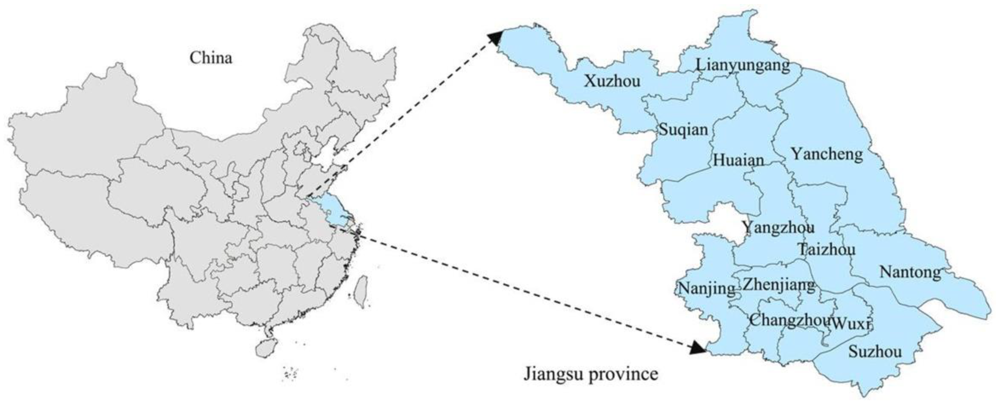
2.1. The Study Area
2.2. Research Methods
2.2.1. Function Evaluation Model
2.2.2. ESDA Model
2.2.3. Geographic Detector Model
2.3. Data Collection
3. Results
3.1. Overall Pattern Differentiation
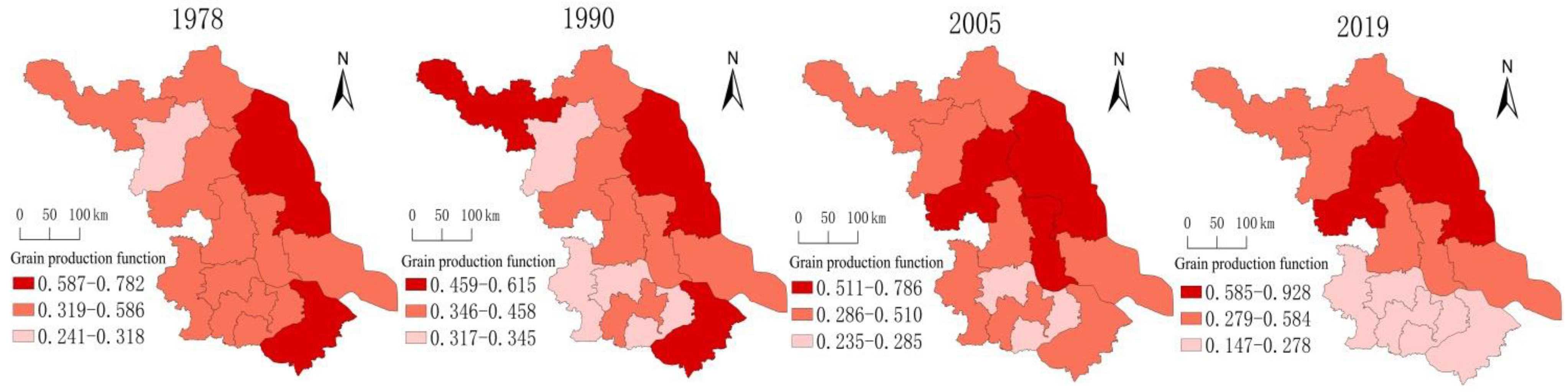
3.1.1. Spatial Differentiation of Grain Production Function
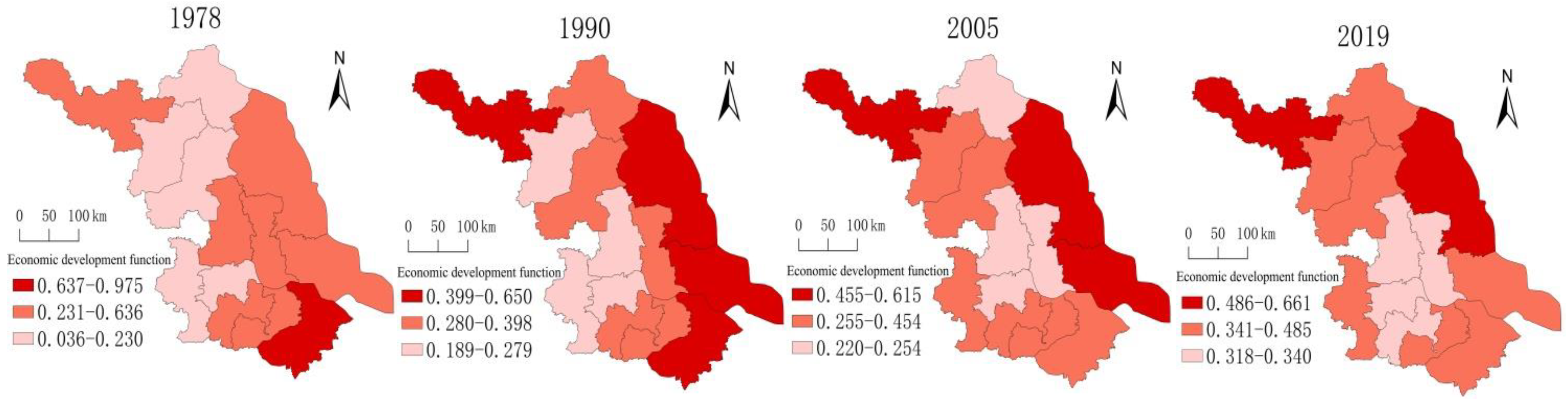
3.1.2. Spatial Differentiation of the Economic Development Function
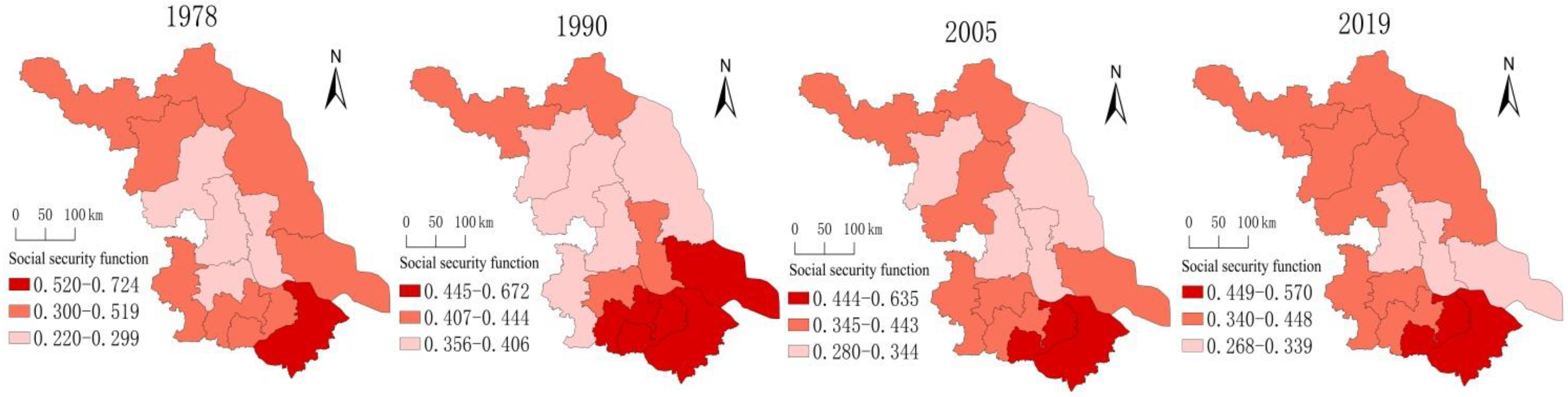
3.1.3. Spatial Differentiation of Social Security Functions
3.1.4. Spatial Differentiation of the Ecotourism Function
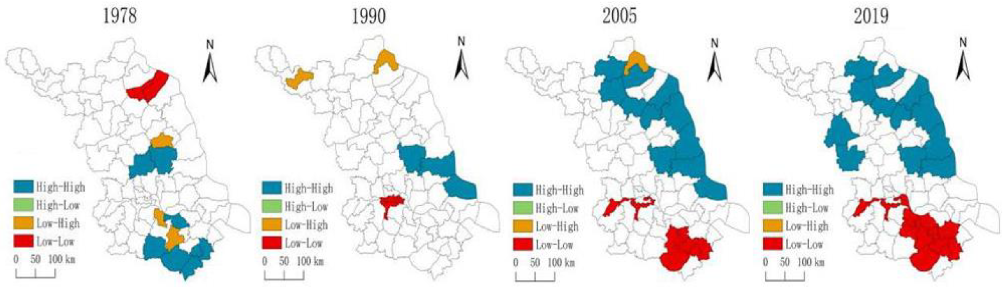
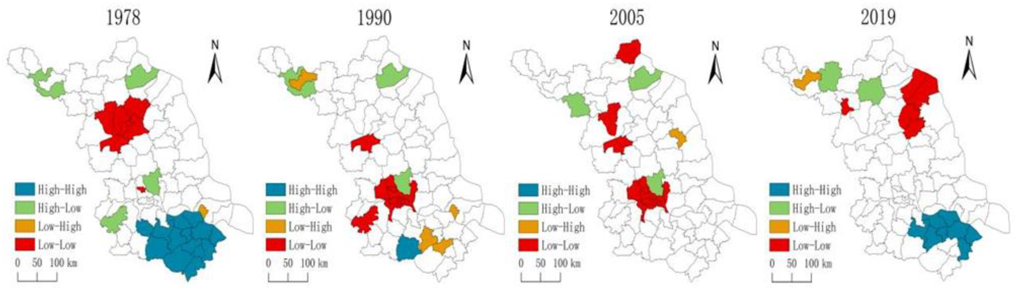
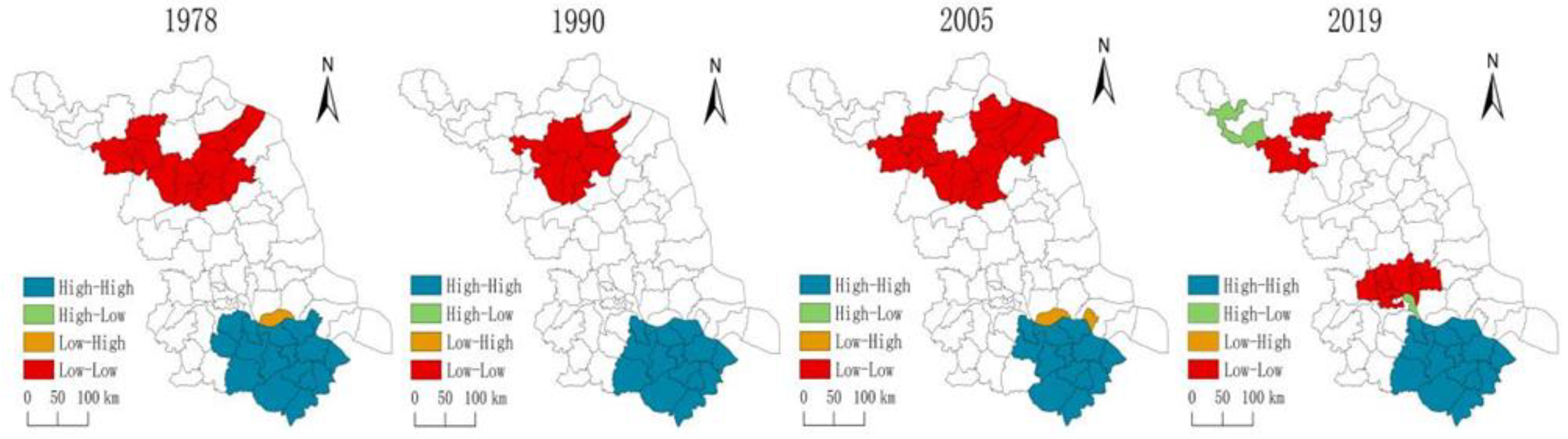
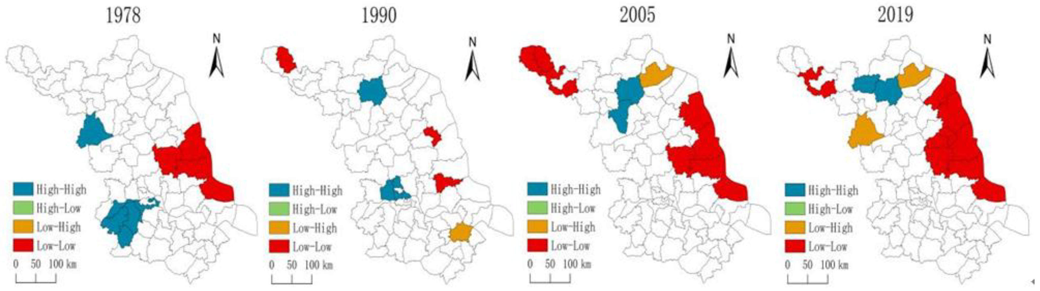
3.2. Agglomeration Pattern Evolution
- (1)
- H–H cluster type: The H–H cluster type of the grain production function showed a trend of transferring from southern Jiangsu to northern Jiangsu. The evolution trend of the H–H cluster pattern of the economic development function and the social security function was relatively consistent and was mainly distributed in southern Jiangsu. The ecotourism function’s H–H cluster type was mainly distributed in the counties around Nanjing-Zhenjiang, near Gaoyou Lake, Hongze Lake, and Luoma Lake. The counties of this type were mainly concentrated in areas with rich mountain and hill resources or dense water networks.
- (2)
- L–L cluster type: The L–L cluster pattern of the grain production function showed a trend of transferring from northern Jiangsu to southern Jiangsu, mainly concentrated in the municipal districts and surrounding areas. The L–L cluster type of the economic development function was mainly distributed in northern Jiangsu and Nanjing–Zhenjiang–Yangzhou. The L–L cluster type of the social security function was mainly distributed in the counties of northern Jiangsu. The L–L cluster type of ecotourism function was mainly distributed in the coastal counties of Jiangsu and some counties of Xuzhou in northern Jiangsu.
- (3)
- H–L cluster type and L–H cluster type: During the study period, the H–L and L–H cluster types of the grain production function, the economic development function, the social security function, and the ecotourism function presented a “point” distribution, their spatial distribution pattern was relatively scattered, and there was no significant spatial agglomeration effect.
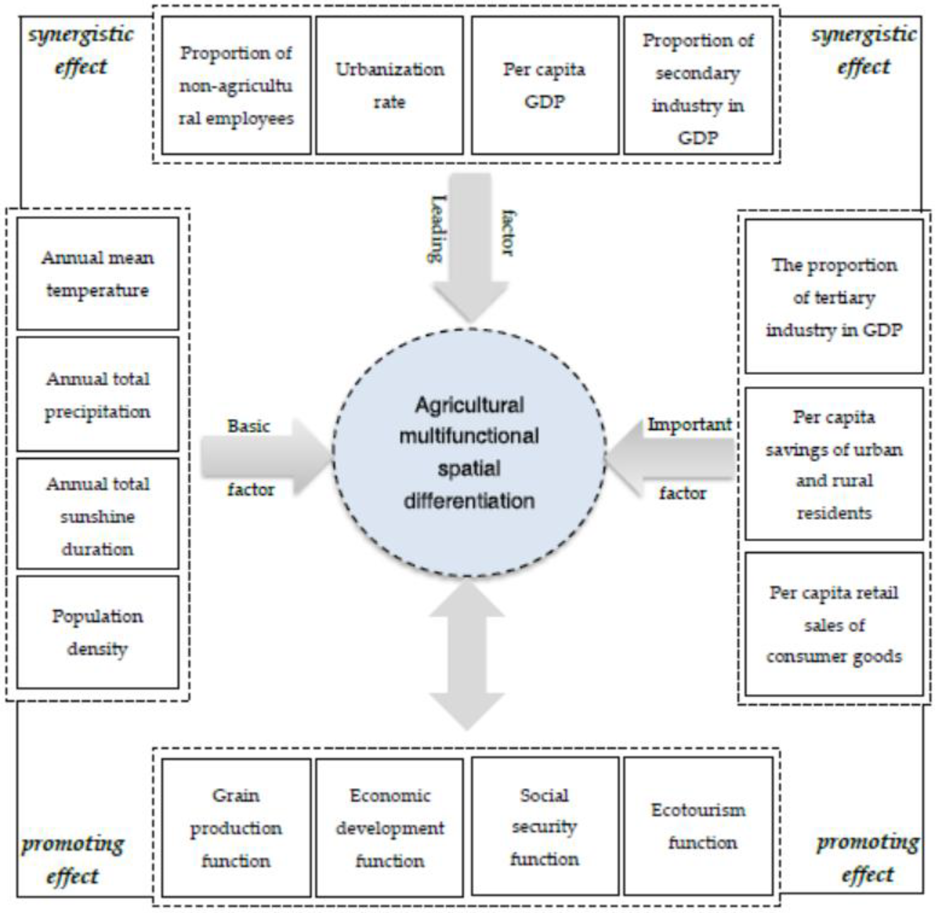
3.3. Analysis of the Driving Mechanism
3.3.1. Factor Index Selection
3.3.2. Dominant Factor Detection
3.3.3. Explanation of the Influencing Mechanisms
- (1)
- The level of regional economic development and the population employment structure were the leading factors of agricultural multifunctional spatial differentiation. Regional economic development has a certain driving effect on the comprehensive development of agriculture; at the same time, as the main body of society, human beings can promote the development of agricultural economic functions and food production functions [58]. In 2019, the per capita GDP of southern Jiangsu reached 167,995 yuan, approximately twice that of northern Jiangsu, which indicated that the economic development level of this region was relatively high and played a greater role in radiating the functions of agricultural economic development. However, economic expansion continued to encroach on cultivated land and destroy the ecological environment, which hindered the development of the agricultural grain production function and the ecotourism function. The rural agricultural labour force of northern Jiangsu was 4.5825 million, approximately 4.7 times that of southern Jiangsu, indicating that the development of its grain production function had obvious advantages and that human activities would cause certain negative effects on the ecological environment.
- (2)
- The industrial structure and people’s living conditions were the important driving forces of agricultural multifunctional spatial differentiation. The transformation and upgrading of the industrial structure and the transformation from the primary industry to the secondary and tertiary industries provided farmers with a large number of employment opportunities and increased the farmers’ income. Their social security function was improved but also led to a surge in the nonagricultural population and a decline in the absorption capacity of agriculture for rural labour, and the development of its food production function was hindered [59]. In 2019, the proportion of output value in the secondary and tertiary industries in southern Jiangsu reached 93%, and the labour force in the secondary and tertiary industries reached 18.951 million, accounting for 92%, indicating that the employment of the rural labour force was obviously being transferred. The improvement of people’s living standards promoted the transformation of their consumption structure from single-staple food consumer goods to high-quality agricultural products and promoted the development of green agriculture and other new models, thus promoting the improvement of agricultural grain production and economic development. At present, the per capita disposable income of residents in southern Jiangsu has reached 55399 yuan, while in northern Jiangsu, it is only 29,380 yuan. The difference in people’s living conditions has had an important impact on the spatial differentiation of the multiple functions of agriculture in Jiangsu.
- (3)
- The natural environment and population density were the basic factors of agricultural multifunctional spatial differentiation. A reduction in the rural population is accompanied by a reduction in agricultural employees, and therefore, agricultural development would be impossible [60]. The natural environment affects the agricultural production, economic development, transportation, and ecological environment in the region, leading to different levels of agricultural multifunctional development in Jiangsu, and the difference between the north and the south was relatively large. In northern Jiangsu, arable land resources are abundant, light and heat resources are well matched, and the number of agricultural workers is large, so its grain production function is prominent. However, the rapid development of industrialisation and urbanisation in southern Jiangsu has led to a reduction in the amount of cultivated land, the transfer of agricultural labour, and a relatively low level of grain production functions.
4. Discussion
- (1)
- Taking Jiangsu Province as a typical case, this paper constructed an evaluation index system of agricultural multiple functions and analysed the spatial evolution and driving mechanism of agricultural multiple functions in economically developed areas since 1978 by using the entropy weight TOPSIS method, the ESDA model, and the geographic detector model. Through this study, the characteristics of the agricultural multifunctional evolution in economically developed areas were preliminarily revealed. Comparing the results of the agricultural multifunction research, it was found that (1) in the research on agricultural multifunction in Jiangsu Province, only Wang [61] used the dynamic factor analysis method to study the change characteristics of agricultural multifunction in Jiangsu Province at the regional level and found that there were regional differences in the level of agricultural multifunction in northern Jiangsu > central Jiangsu > southern Jiangsu. This paper focused on the county scale to reveal the spatial agglomeration characteristics of different agricultural functions at the county level, such as the grain production function, the economic development function, the social security function, and the ecotourism function, which provides guidance for the coordinated development of Jiangsu’s agricultural multifunction at the county scale and ideas for the optimisation of county agricultural multifunction zoning from the perspective of dominant functions. (2) As for the research on the influencing factors of agricultural multifunction, at present, scholars such as Barnes [62], Fang [63], and Peng [64] have studied the driving factors of the spatial differentiation of agricultural multifunction, and most of them were qualitative descriptions. This paper selected the geographical detector model to study the dominant factors of the spatial differentiation of the different functions of grain production, economic development, social security, and ecotourism, thus revealing the driving mechanisms of the spatial differentiation of agricultural multifunction in Jiangsu, which will help improve the understanding of the driving mechanisms of agricultural multifunction spatial differentiation in economically developed areas.
- (2)
- At present, under the condition of sustainable development and the progress of the social economy, the agricultural industry is increasingly showing its multifunctional value. In the future, agricultural development should continue to consolidate the basic position of agriculture. It should be recognised that agriculture not only has the economic function of grain production but also has the functions of social security and ecotourism to promote the diversified development of agricultural functions. Combined with the analysis of spatial differentiation and the driving mechanisms of agricultural multifunction in Jiangsu since 1978, it is necessary to give full consideration to natural conditions and resource endowments; give full play to regional comparative advantages; adhere to the principles of zoning optimisation, regional coordination, and overall planning; and put forward future agricultural multifunction optimisation suggestions in Jiangsu Province [65,66]:
- (1)
- The advantageous area of the grain production function of agriculture: In the future, on the basis of stabilising grain production guarantees, the advantageous regions of the grain production function in northern Jiangsu should speed up the cultivation of the intensive processing industry of agricultural products and build a base for agricultural production and processing by integrating production, supply, and marketing. At the same time, we should increase support for regional organic agriculture and promote the development of green agriculture.
- (2)
- The advantageous area of the economic development function of agriculture: In the future, the advantageous areas of the economic development function in southern Jiangsu should increase the development of their characteristic agriculture, expand the agricultural industrial chain, strengthen the integrated development of agriculture and secondary and tertiary industries, vigorously develop high-efficiency facility agriculture focusing on characteristic planting and leisure picking, and strive to build a characteristic agricultural industrial cluster model in the suburbs of the city.
- (3)
- The advantageous area of the ecotourism function of agriculture: In the future, the ecotourism function’s advantageous areas around Nanjing–Zhenjiang and Gaoyou Lake should fully tap into the local agricultural ecological advantages, carry out the planting of the forest and fruit industry and other characteristic agricultural economic crops, vigorously develop the leisure agricultural tourism industry, actively develop agricultural ecotourism, and take the route of eco-economic characteristic development.
5. Conclusions
- (1)
- The spatial pattern of agriculture multifunction was significantly different at the city scale in economically developed areas. The cities with higher grain production functions were mainly concentrated in Yancheng and Huai’an in northern Jiangsu, both of which are rich in cultivated land resources. The cities with higher economic development functions were mainly distributed in the coastal areas of Jiangsu. The cities with higher social security functions were mainly distributed in the economically developed Suzhou–Wuxi–Changzhou metropolitan area, and the level of the economic developmental function in northern Jiangsu had an obvious increasing trend during the study period. The cities with higher agricultural ecotourism functions evolved from the Nanjing–Zhenjiang area to the Suzhou–Wuxi–Changzhou area.
- (2)
- The local spatial agglomeration patterns of agricultural multiple functions at the county scale were different, and the spatial agglomeration of different agricultural functions provides a spatial optimisation perspective for agricultural functions at the county scale in economically developed areas. The H–H cluster pattern of the agricultural grain production function in Jiangsu shifted from southern Jiangsu to northern Jiangsu, and the L–L cluster pattern was opposite to this changing trend. The H–H cluster of the economic development function was mainly distributed in southern Jiangsu, while the L–L cluster type was mainly distributed in northern Jiangsu and Nanjing–Zhenjiang–Yangzhou. The H–H cluster of the social security function was mainly distributed in southern Jiangsu, while the L–L cluster was mainly distributed in northern Jiangsu. The H–H cluster type of the ecotourism function was mainly distributed in the counties near Nanjing–Zhenjiang, Gaoyou Lake, Hongze Lake, and Luoma Lake, and this type of function at the county level was mainly concentrated in areas with rich mountains and hilly resources or dense water networks.
- (3)
- The diversity of agricultural multifunctional patterns in economically developed areas was the comprehensive result of natural, population, and economic factors, and the effects of the intensity of factors on agricultural grain production function, economic development function, social security function, and ecotourism function were different. The level of economic development and the structure of population employment were the leading factors of the spatial differentiation of agricultural multifunction; the industrial structure and people’s living conditions were the important driving forces for the spatial differentiation of agricultural multifunction; and the natural environment and population density were the basic factors of spatial differentiation of agricultural multifunction. In the future, the pattern evolution of agricultural multifunction in economically developed areas will be mainly driven by the leading factors of economic and social development.
- (4)
- This paper aimed to provide a practical reference for the optimisation of agricultural functions at the city and county scales and to provide practical guidance at the meso scale. In the future, research on agricultural multiple functions should further focus on the microscale, such as rural areas and farmers. The exploration of the relationship, evolution path, and development trend of agricultural multiple functions at the microscale, deeply revealing the impacts and mechanisms of local governments, enterprises, farmers, and other different subjects on the development of agricultural multiple functions, is a research direction that needs to be explored further.
Author Contributions
Funding
Data Availability Statement
Conflicts of Interest
References
- Randall, A. Valuing the outputs of multifunctional agriculture. Eur. Rev. Agric. Econ. 2002, 29, 289–307. [Google Scholar] [CrossRef]
- Lu, S.S.; Guan, X.L.; Liu, Y.S.; He, C. Agricultural region type identification and its spatio-temporal evolution characteristics: A case study of sampling belt along G106 in China. Prog. Geogr. 2013, 32, 637–648. [Google Scholar]
- Sun, X.Z. Evolution of Agricultural Multifunctionality Since 1949. China Popul. Resour. Environ. 2010, 20, 71–75. [Google Scholar]
- Rozan, A.; Stenger, A.; Willinger, M. Willingness to pay for food safety: An experimental investigation of quality certification on bidding behaviour. Eur. Rev. Agric. Econ. 2004, 31, 409–425. [Google Scholar] [CrossRef]
- Bernsten, J.; Peterson, B.M.; Jacobsen, B.H.; Olesen, J.E.; Hutchings, N.J. Evaluating nitrogen taxation scenarios using the whole farm simulation model FASSET. Agric. Syst. 2003, 76, 817–839. [Google Scholar]
- Brunstad, R.J. Multifunctionality of agriculture: An inquiry into the complementarities between landscape preservation and food security. Eur. Rev. Agric. Econ. 2005, 32, 469–488. [Google Scholar] [CrossRef]
- Lankoski, J.; Ollikainen, M. Agri-environmental externalities: A framework for designing targeted policies. Eur. Rev. Agric. Econ. 2003, 30, 51–75. [Google Scholar] [CrossRef]
- Peng, J.; Liu, Z.C.; Liu, Y.X. Research progress on assessing multi-functionality of agriculture. Chin. J. Agric. Resour. Reg. Plan. 2014, 35, 1–8. [Google Scholar]
- UNCED (United Nations Conference on Environment and Development). Agend 21-An Action Plan for the Next Century. In Proceedings of the United Nations Conference on Environment and Development, Rio de Janeiro, Brazil, 3–14 June 1992. [Google Scholar]
- Mougeot, L.J. Urban agriculture: Concept and definition. Urban Agric. Mag. 2000, 1, 5–7. [Google Scholar]
- Jeanne, D.B.; Tina, R. Choice experiment, multiple programmers contingent valuation and landscape preferences: How can we support the land use decision making process. Land Use Policy 2012, 29, 846–854. [Google Scholar]
- Irene, P.B. Territorial sustainability and multifunctional agriculture: A case study. Agric. Agric. Sci. Procedia 2016, 8, 467–474. [Google Scholar]
- Zasada, I. Multifunctional peri-urban agriculture-A review of societal demands and the provision of goods and services by farming. Land Use Policy 2011, 4, 639–648. [Google Scholar] [CrossRef]
- Marsden, T.; Sonnino, R. Rural development and the regional state: Denying multifunctional agriculture in the UK. J. Rural. Stud. 2008, 4, 422–431. [Google Scholar] [CrossRef]
- Pitman, W.D. Multifunctional landscapes for enhanced ecosystem benefits and productive agriculture in the southeastern US. Landsc. Ecol. 2022, 37, 1957–1971. [Google Scholar] [CrossRef]
- Kittur, S.; Sundar, K.S.G. Of irrigation canals and multifunctional agroforestry: Traditional agriculture facilitates Woolly-necked Stork breeding in a north Indian agricultural landscape. Glob. Ecol. Conserv. 2021, 30, 1793. [Google Scholar] [CrossRef]
- Vanslembrouck, I.; Van, H.G. Multifunctionality in agriculture: Supply of and demand for landscape amenities. Mededelingen 2001, 66, 63–68. [Google Scholar]
- Wagner, K. Regional future scenarios for rural space types in Austria. Rural. Areas Dev. 2003, 1, 57–64. [Google Scholar]
- Refsgaard, K.; Johnson, T.G. Modelling policies for multifunctional agriculture and rural development-a norwegian case study. Environ. Policy Gov. 2010, 20, 239–257. [Google Scholar] [CrossRef]
- Pourias, J.; Aubry, C.; Duchemin, E. Is food a motivation for urban gardeners? Multifunctionality and the relative importance of the food function in urban collective gardens of Paris and Montreal. Agric. Hum. Values 2015, 33, 257–273. [Google Scholar] [CrossRef]
- He, S.; Lin, L.; Xu, Q.; Hu, C.; Zhou, M.; Liu, J.; Li, Y.; Wang, K. Farmland zoning integrating agricultural multi-functional supply, demand and relationships: A case study of the Hangzhou Metropolitan Area, China. Land 2021, 10, 1014. [Google Scholar] [CrossRef]
- Kiminami, L.; Kiminami, A.; Furuzawa, S. Impacts of multi-functionality of urban agriculture on the CCs in Japan. Asia-Pac. J. Reg. Sci. 2018, 2, 507–527. [Google Scholar] [CrossRef]
- Zhong, Y.; Liu, L.M.; Liu, X.; Du, S.L. Multi-function evaluation and functional zoning of agriculture: A case study of Hunan Province. Chin. J. Agric. Resour. Reg. Plan. 2017, 38, 93–100. [Google Scholar]
- Chen, Q.Z.; John, S. Summary of viewpoints in domestic and oversea research into agricultural multifunctionality. China Rural Surver 2007, 3, 71–79. [Google Scholar]
- Tan, X.L.; Wang, Z.K.; Jiang, L.X.; An, Y.; Lei, J.H.; Ren, H. Analysis on spatio-temporal evolution of agricultural function and its influencing factors in Dongting Lake area. Sci. Geogr. Sin. 2020, 40, 1355–1364. [Google Scholar]
- Li, S.N.; Zhu, C.M.; Lin, Y.; Dong, B.Y.; Chen, B.J.; Si, B.; Li, Y.J.; Deng, X.D.; Gan, M.Y.; Zhang, J.; et al. Conflicts between agricultural and ecological functions and their driving mechanisms in agroforestry ecotone areas from the perspective of land use functions. J. Clean. Prod. 2021, 317, 128453. [Google Scholar] [CrossRef]
- Fang, Y.G.; Liu, B.C.; Liu, J.Z. Territorial types and optimization strategies of agriculture multifunction: A case study of Jilin Province. Prog. Geogr. 2019, 38, 1349–1360. [Google Scholar] [CrossRef]
- Kai, Y.H.; Wang, X. Dynamic multifunctionality evaluation of urban agriculture directed by resilient city—An empirical study of Shanghai from 1993 to 2014. Reform Econ. Syst. 2017, 1, 81–88. [Google Scholar]
- He, L.; Min, Q.W.; Zhang, D. Evaluation models for multifunctionality of agriculture and their applications: A case study on Qingtian county in Zhejiang province, China. Resour. Sci. 2010, 32, 1057–1064. [Google Scholar]
- Li, M.T.; Zhou, Z.X. Evaluation of urban agriculture multi-functionality development models based on multi-dimension evaluation. Chin. J. Eco-Agric. 2016, 24, 1275–1284. [Google Scholar]
- Wang, M.; Zhou, Z.X.; Feng, H.J. Coordinated development of urban agricultural multi-functionality of Xi’an metropolitan zone. Arid. Land Geogr. 2015, 38, 858–866. [Google Scholar]
- Lv, Y. Evaluation of multi-functionality of agriculture based on multi-dimension evaluation model. Econ. Geogr. 2008, 28, 650–655. [Google Scholar]
- Yu, M.; Yang, Y.J.; Chen, F.; Zhu, F.; Qu, J.; Zhang, S. Response of agricultural multi-functionality to farmland loss under rapidly urbanizing processes in Yangtze River Delta, China. Sci. Total Environ. 2019, 666, 1–11. [Google Scholar] [CrossRef] [PubMed]
- Schipanski, M.E.; Barbercheck, M.; Douglas, M.R.; Finney, D.M.; Haider, K.; Kaye, J.P.; Kemanian, A.R.; Mortensen, D.A.; Ryan, M.R.; Tooker, J.; et al. A framework for evaluating ecosystem services provided by cover crops in agroecosystems. Agric. Syst. 2014, 25, 12–22. [Google Scholar] [CrossRef]
- Tan, C.F.; Wang, S.L. Epirical research on multi-fuction value of agriculture in arid and semiarid areas of northwest China. J. Northwest AF Univ. (Soc. Sci. Ed.) 2012, 12, 41–44. [Google Scholar]
- Lu, S.S.; Liu, Y.S.; Qin, F. Spatio-temporal differentiation of agricultural regional function and its impact factors in the Bohai Rim region of China. Acta Geogr. Sin. 2019, 74, 2011–2026. [Google Scholar]
- Liu, B.C.; Fang, Y.G. Characteristics and territorial types of agriculture multifunction evolution in Mid-southern Liaoning Urban Agglomeration. Sci. Geogr. Sin. 2020, 40, 1720–1730. [Google Scholar]
- Tan, X.L.; An, Y.; Su, Y.; Zhou, G.; He, Y. Spatio-temporal Dynamics of Agricultural Function in Changsha-Zhuzhou-Xiangtan Urban Agglomerations. Sci. Geogr. Sin. 2018, 38, 708–716. [Google Scholar]
- Casamatta, G.; Rausser, G.; Simon, L. Optimal taxation with joint production of agriculture and rural amenities. Resour. Energy Econ. 2011, 33, 544–553. [Google Scholar] [CrossRef]
- Dibden, J.; Potter, C.; Cocklin, C. Contesting the neoliberal project for agriculture: Productivist and multifunctional trajectories in the European Union and Australia. J. Rural. Stud. 2009, 25, 299–308. [Google Scholar] [CrossRef]
- Moon, W. Conceptualising multifunctional agriculture from a global perspective: Implications for governing agricultural trade in the post-Doha Round era. Land Use Policy 2015, 49, 252–263. [Google Scholar] [CrossRef]
- Wilson, G.A.; Burton, R.J. “Neo-productivist” agriculture: Spatio-temporal versus structuralist perspectives. J. Rural. Stud. 2015, 38, 52–64. [Google Scholar] [CrossRef]
- Huang, J.; Li, S.C. A review of change in agricultural multi-functionality in metropolitan areas under rapid urbanization in China. Res. Sci. 2018, 40, 664–675. [Google Scholar]
- Smith, F. Multifunctionality and non-trade concerns in the agriculture negotiations. J. Int. Econ. Law. 2005, 3, 707–713. [Google Scholar] [CrossRef]
- Li, P.X.; Chen, C.; Chen, J.L. Temporal Evolution and Spatial Differentiation of Rural Territorial Multifunctions and the Influencing Factors: The Case of Jiangsu Province. Sci. Geogr. Sin. 2015, 35, 845–851. [Google Scholar]
- Jahanshahloo, G.R.; Lotfi, F.H.; Izadikhah, M. Extension of the TOPSIS method for decision making problems with fuzzy data. J. Appl. Math. 2006, 181, 544–551. [Google Scholar] [CrossRef]
- Anselin, L. Local indicators of spatial association: LISA. Geogr. Anal. 1995, 27, 93–115. [Google Scholar] [CrossRef]
- Pan, J.W.; Chen, Y.Y.; Zhang, Y.; Chen, M.; Fennell, S.; Luan, B.; Wang, F.; Meng, D.; Liu, Y.; Jiao, L.; et al. Spatial-temporal dynamics of grain yield and the potential driving factors at the county level in China. J. Clean. Prod. 2020, 255, 120312. [Google Scholar] [CrossRef]
- Cartone, A.; Casolani, N.; Liberatore, L.; Postiglione, P. Spatial analysis of grey water in Italian cereal crops production. Land Use Policy 2017, 68, 97–106. [Google Scholar] [CrossRef]
- Guo, L.J.; Li, P.Z.; Zhang, J.H.; Xiao, X.; Peng, H. Do socio-economic factors matter? A comprehensive evaluation of tourism eco-efficiency determinants in China based on the Geographical Detector Model. J. Environ. Manag. 2022, 320, 115812. [Google Scholar] [CrossRef]
- Wang, J.F.; Yu, C.D. Geodetector: Principle and prospective. Acta Geogr. Sinca 2017, 72, 116–134. [Google Scholar]
- Anselin, L. Spatial Econometrics: Methods and Models; Kluwer: Dordrecht, The Netherlands, 1988. [Google Scholar]
- Cliff, A.D.; Ord, J.K. Spatial Processes: Models and Applications; Pion Ltd.: London, UK, 1981. [Google Scholar]
- Wang, J.F.; Li, X.H.; Christakos, G.; Liao, Y.-L.; Zhang, T.; Gu, X.; Zheng, X.-Y. Geographical detectors- based health risk assessment and its application in the neural tube defects study of the Heshun region, China. Int. J. Geogr. Inf. Sci. 2010, 24, 107–127. [Google Scholar] [CrossRef]
- Wilson, G.A. The spatiality of multifunctional agriculture: A human geography perspective. Geoforum 2009, 40, 269–280. [Google Scholar] [CrossRef]
- Mkwambisi, D.D.; Fraser, E.D.G.; Dougill, A.J. Urban agriculture and poverty reduction: Evaluating how food production in cities contributes to food security, employment and income in Malawi. J. Int. Dev. 2011, 23, 181–203. [Google Scholar] [CrossRef]
- Potter, C.; Burney, J. Agricultural multifunctionality in the WTO: Legitimate non-trade concern or disguised protectionism? J. Rural. Stud. 2002, 18, 35–47. [Google Scholar] [CrossRef]
- Ma, J.; Ma, Y.; Zhang, C.; Gu, X.J. Review of urban multifunctional agriculture studies. Chin. Agric. Sci. Bull. 2014, 30, 83–87. [Google Scholar]
- Firbank, L.; Bradbury, R.B.; McCracken, D.I.; Stoate, C. Delivering multiple ecosystem services from Enclosed Farmland in the UK. Agric. Ecosyst. Environ. 2013, 166, 65–75. [Google Scholar] [CrossRef]
- Liu, Y.S.; Liu, Y.; Chen, Y.F. Territorial multi- functionality evaluation and decision-making mechanism at county scale in China. Acta Geogr. Sin. 2011, 66, 1379–1389. [Google Scholar]
- Wang, H.; Xiao, Y.P.; Wang, K. Research on agricultural multifunctional development in Jiangsu Province based on dynamic factor analysis. Bus. Econ. Res. 2015, 35, 132–134. [Google Scholar]
- Barnes, A.P. Does multi-functionality affect technical efficiency? A non-parametric analysis of the Scottish dairy industry. J. Environ. Manag. 2006, 80, 287–294. [Google Scholar] [CrossRef]
- Liu, J.Z.; Fang, Y.G.; Wang, R.R. Spatio-temporal evolution characteristics and driving mechanisms of agricultural multifunctions in Shandong province. J. Nat. Resour. 2020, 12, 2901–2915. [Google Scholar] [CrossRef]
- Gao, J.Y.; Peng, J. Quantitative evaluation and driving force analysis of agricultural multifunctional classification in Wuhan city. Chin. J. Agric. Resour. Reg. Plan. 2021, 9, 156–165. [Google Scholar]
- Peng, J.; Liu, Z.; Liu, Y.; Hu, X.; Wang, A. Multifunctionality assessment of urban agriculture in Beijing City, China. Sci. Total Environ. 2015, 537, 343–351. [Google Scholar] [CrossRef] [PubMed]
- Renting, H.; Rossing, W.A.H.; Groot, J.C.J.; van der Ploeg, J.; Laurent, C.; Perraud, D.; Stobbelaar, D.; van Ittersum, M. Exploring multifunctional agriculture: A review of conceptual approaches and prospects for an integrative transitional framework. J. Environ. Manag. 2009, 3, 112–123. [Google Scholar] [CrossRef] [PubMed]


| Function | Index | Index Attribute | Weight |
|---|---|---|---|
| Grain production function | Grain yield per unit area | + | 0.0683 |
| Per capita grain availability | + | 0.0624 | |
| Grain sown area | + | 0.0892 | |
| Economic development function | Total agricultural output value | + | 0.1022 |
| Proportion of total agricultural output value in GDP | + | 0.1267 | |
| Per capita net income of farmers | + | 0.1129 | |
| Social security function | Rural agricultural employment rate | + | 0.1183 |
| Added value of labour per capita primary industry | + | 0.0922 | |
| Rural Engel coefficient | - | 0.0718 | |
| Ecotourism function | Forest coverage rate | + | 0.0665 |
| Agricultural fertiliser consumption | - | 0.0568 | |
| Proportion of agricultural tourism income in GDP | + | 0.0785 |
| Year | Grain Production Function | Economic Development Function | Social Security Function | Ecotourism Function |
|---|---|---|---|---|
| 1978 | 0.1352 | 0.4088 | 0.7390 | 0.3141 |
| 1990 | 0.1430 | 0.1340 | 0.4017 | 0.1330 |
| 2005 | 0.4772 | 0.1707 | 0.7547 | 0.3295 |
| 2019 | 0.5718 | 0.2384 | 0.6042 | 0.3219 |
| Index | Grain Production Function | Economic Development Function | Social Security Function | Ecotourism Function | ||||
|---|---|---|---|---|---|---|---|---|
| q Value | Rank | q Value | Rank | q Value | Rank | q Value | Rank | |
| Annual mean temperature | 0.760 | 2 | 0.175 | 10 | 0.241 | 9 | 0.609 | 4 |
| Annual total precipitation | 0.563 | 8 | 0.234 | 9 | 0.220 | 10 | 0.501 | 9 |
| Annual total sunshine duration | 0.670 | 4 | 0.124 | 11 | 0.117 | 11 | 0.618 | 3 |
| Proportion of nonagricultural employees | 0.833 | 1 | 0.659 | 3 | 0.728 | 2 | 0.575 | 6 |
| Population density | 0.702 | 3 | 0.449 | 8 | 0.501 | 6 | 0.541 | 7 |
| Urbanisation rate | 0.592 | 5 | 0.526 | 4 | 0.513 | 5 | 0.697 | 2 |
| Per capita GDP | 0.578 | 7 | 0.717 | 1 | 0.833 | 1 | 0.606 | 5 |
| Proportion of secondary industry in GDP | 0.580 | 6 | 0.683 | 2 | 0.551 | 4 | 0.766 | 1 |
| Proportion of tertiary industry in GDP | 0.328 | 11 | 0.450 | 7 | 0.455 | 7 | 0.411 | 10 |
| Per capita savings of urban and rural residents | 0.402 | 9 | 0.507 | 5 | 0.708 | 3 | 0.507 | 8 |
| Per capita retail sales of social consumer goods | 0.342 | 10 | 0.496 | 6 | 0.453 | 8 | 0.363 | 11 |
Publisher’s Note: MDPI stays neutral with regard to jurisdictional claims in published maps and institutional affiliations. |
© 2022 by the authors. Licensee MDPI, Basel, Switzerland. This article is an open access article distributed under the terms and conditions of the Creative Commons Attribution (CC BY) license (https://creativecommons.org/licenses/by/4.0/).
Share and Cite
Zhang, R.; Chen, M. Spatial Differentiation and Driving Mechanism of Agricultural Multifunctions in Economically Developed Areas: A Case Study of Jiangsu Province, China. Land 2022, 11, 1728. https://doi.org/10.3390/land11101728
Zhang R, Chen M. Spatial Differentiation and Driving Mechanism of Agricultural Multifunctions in Economically Developed Areas: A Case Study of Jiangsu Province, China. Land. 2022; 11(10):1728. https://doi.org/10.3390/land11101728
Chicago/Turabian StyleZhang, Rongtian, and Ming Chen. 2022. "Spatial Differentiation and Driving Mechanism of Agricultural Multifunctions in Economically Developed Areas: A Case Study of Jiangsu Province, China" Land 11, no. 10: 1728. https://doi.org/10.3390/land11101728