Article

Multi-Dimensional Feature Recognition and Policy Implications of Rural Human–Land Relationships in China

1
School of Management Engineering, Shandong Jianzhu University, Jinan 250101, China
2
State Key Laboratory of Resources and Environmental Information Systems, Institute of Geographic Sciences and Natural Resources Research, Chinese Academy of Sciences, Beijing 100101, China
3
Shandong Institute of Territorial Space Planning, Jinan 250101, China
*
Author to whom correspondence should be addressed.
Land 2021, 10(10), 1086; https://doi.org/10.3390/land10101086
Submission received: 23 September 2021 / Revised: 10 October 2021 / Accepted: 12 October 2021 / Published: 14 October 2021
(This article belongs to the Special Issue Efficient Land Use and Sustainable Urban Development)

Abstract

:
Rural decline has become an indisputable fact and a global issue. As a developing country, China is simultaneously facing unprecedented rapid urbanization and severe rural decline. The coordinated development of its rural human–land relationship is therefore of great significance for ensuring the country’s food security and achieving both rural revitalization and sustainable development. Yet, the related research on this complex subject has mostly focused on a single element: rural settlements. Since studies of the rural human–land relationship tend to only discuss the coordinated change in rural populations vis-à-vis rural settlement area, their degree of spatial matching and intensive utilization level of rural settlements has been largely overlooked. To rectify this imbalance, using data on rural populations and rural settlement area in counties of Shandong Province in 2009 and 2018, this paper applied the methods of per capita rural settlement area, the Theil index, and Tapio’s decoupling model to quantitatively identify the rural human–land relationship along three dimensions: intensive utilization level, spatial matching degree, and change coordination degree. The results revealed that the per capita rural settlement area in Shandong Province was as high as 212.18 m2/person in 2018, which exceeded the standard to varying degrees in all cities, having an overall geographical pattern of being high in the north and low in the south. The Theil index for all cities was small, which indicates that the spatial matching between rural population and rural settlements is high. To sum up, there are small differences in the utilization of rural settlements among cities, and their extensive utilization of rural settlements is a common phenomenon. In addition, the relationship between the changes in the rural population size and rural settlement area corresponded to a discordant state, in the form of strong negative decoupling, expansive negative decoupling, and expansive coupling; however, among them, the strong negative decoupling type was the dominant type. It is worth noting that all of these three types will exacerbate the extensive utilization of rural settlements. Accordingly, this paper proposes policies and measures, such as the paid withdrawal of rural homesteads, an expanded scope of homestead transfer, cross-regional “increasing versus decreasing balance”, classified promotion of rural revitalization, and improved village planning.

1. Introduction

The world has entered the urban age, with more than half of the planet’s population living in urban areas, a proportion predicted to reach two-thirds by 2050 [1]. At the same time, rural decline is an indisputable fact and a global issue [2,3]. Rapidly increasing human–land conflicts have been witnessed in both developed and developing countries during the past century [4,5]. Population pressure in the United States varies significantly by region, with the Southeast coast and the Southwest facing more stress [4]. As a developing country, China has experienced unprecedented urbanization since the implementation of the reform and opening-up policy in 1978 [6,7], with its demographic urbanization rate increasing from 17.92% in 1978 to 60.60% in 2019, during which time people’s living standards greatly improved. Yet, the development of urban and rural areas in China is extremely imbalanced [8,9]. Moreover, urban development often comes at the expense of rural areas [2,3,6,8]. An extensive urbanization development mode and urban-biased development policy have forced China to face more severe rural decline.
The rural human–land relationship is the most direct manifestation and most fundamental characteristic of rural decline. Due to the impact of urbanization, population mobility, and other socio-economic factors, China’s rural population as a proportion of its populace has been continuously decreasing since 1978, falling from 82.08% to 39.40% in 2019. The total rural population reached its maximum value of 859 million in 1995, since then declining to 552 million in 2019. This reduction in the rural population has led to the loss of a rural labor force, the shortage of rural governance talent, and a diminished endogenous impetus for pursuing rural development, all of which further intensifies rural decline. Still, rural settlement areas have not decreased along with the decrease in the rural population, instead showing a trend of continuous increase over time [10,11,12]. Spatially, rural settlements and cultivated land are often situated near each other; therefore, the disorderly expansion of rural settlements not only causes a waste of land resources and the deterioration of rural living quality [13,14], but also inevitably occupies a large amount of high-quality cultivated land [15,16,17], thereby threatening food security. To sum up, China’s rural population and rural settlement area showed a reverse trend of increase and decrease, which leads to a suite of inter-related problems, such as abandoned farmland [18,19,20], hollow villages [21], land-use conflict [22,23,24], and ecological destruction [13,14,25], among others. Therefore, the coordinated development of rural human–land relationships is of great significance for ensuring food security and realizing rural revitalization.
Much effort has gone into better understanding the rural human–land relationship and its aspects. Numerous studies have analyzed the spatiotemporal pattern of rural settlement and the underlying driving forces [25,26,27,28,29,30]. The internal land-use structure and function of rural settlement has also been investigated from a microcosmic perspective [31,32]. Other studies have further addressed rural settlement transformation and rural reconstruction [33,34,35,36,37]. Clearly, then, such studies have provided a valuable step forward in helping to understand the rural human–land relationship in China [38,39]. Nevertheless, most of the research on this topic has focused on single factors of rural settlements. In the new era, rural transformation development, rural reconstruction, and rural revitalization demand higher requirements for the optimal allocation of land resources, which will spur people to re-examine the human–land relationship from the perspective of its enhanced coordination [40]. The benign pattern of cooperative evolution between the rural population and rural settlement area has not yet appeared. During the period 1996–2005, the decoupling of the rural population and its rural settlements increased [10]. At the scale of prefecture-level city, the rural human–land relationship is discordant, in that there is a rapid decrease in population size alongside an increase in rural settlement area [11], and the rural human–land relationship in most counties of Jiangsu Province is evidently uncoordinated [12]. These studies mainly used Tapio’s decoupling model to analyze the relationship between the spatiotemporal rate of changes in rural population sizes and rural settlement area, which is helpful for understanding the rural human–land relationship from the perspective of human–land coordination. There are some shortcomings to this, however: it only focuses on the coordination between rural population size and rural settlement area changes, and ignores the spatial matching degree and quantitative relationship between the rural population size and rural settlement area.
Therefore, the main objective of this study is to quantitatively characterize the rural human–land relationship in China. Specifically, it includes the following two objectives: (1) to analyze the spatiotemporal pattern of the rural population and rural settlement area; (2) quantitatively describe the level of intensive use of rural settlements, the spatial matching degree of the rural population and rural settlement area, and the decoupling relationship between rural the population and rural settlement area by using methods such as per capita rural settlement area, the Theil index, and Tapio’s elastic decoupling model.

2. Materials and Methods

2.1. Study Area

Shandong Province is located on the east coast of China and the lower reaches of the Yellow River (34°22.9′–38°24.01′ N, 114°47.5′–122°42.3′ E; Figure 1). The west and north of Shandong are low-lying and flat, belonging to the North China Plain; central and southern Shandong is mountainous; the eastern part of Shandong is hilly. Shandong has a warm temperate monsoon climate. By 2018, Shandong Province had jurisdiction over 17 prefecture-level cities and 136 county-level administrative regions.
In 2019, the current level of urbanization of Shandong reached 61.51%, however, 455,700 people still lived in the countryside. Furthermore, the villages of Shandong are large in number but small in scale, with a scattered distribution and high density. The number of administrative villages in Shandong now totals 69,500, ranking it first in China; however, their average population size is 530 people, which ranks second to last in China. Hence, this rural human–land contradiction is prominent in Shandong Province.

2.2. Data Sources

The county statistics of rural settlement areas in 2009 and 2018 were obtained from the Land Survey and Planning Institute of Shandong Province. In 2009, China completed the second national land-use survey, on the basis of which land-use change surveys have been conducted yearly. Therefore, 2009 to 2018 was selected as this study’s research period to ensure the consistency, accuracy, comparability, and authority of the data analyzed. Rural population data were obtained from statistical yearbooks of municipalities in the corresponding years.

2.3. Methods

To resolve the three outstanding issues mentioned in the Introduction, a research scheme was formulated, which is shown in Figure 2. Firstly, based on the rural population and rural settlements data in 2009 and 2018, the methods of spatial analysis and standard deviation ellipse were used to quantitatively describe the spatiotemporal characteristics of rural populations and rural settlement area. Secondly, the per capita rural settlement area, the Theil index, and Tapio’s elastic decoupling model were adopted to conduct the multi-dimensional identification of the rural human–land relationship from the aspects of intensive utilization level, spatial matching degree, and change coordination degree. Finally, the multi-dimensional characteristics of the rural human–land relationship are comprehensively analyzed, and the formation mechanism and policy implications are discussed.

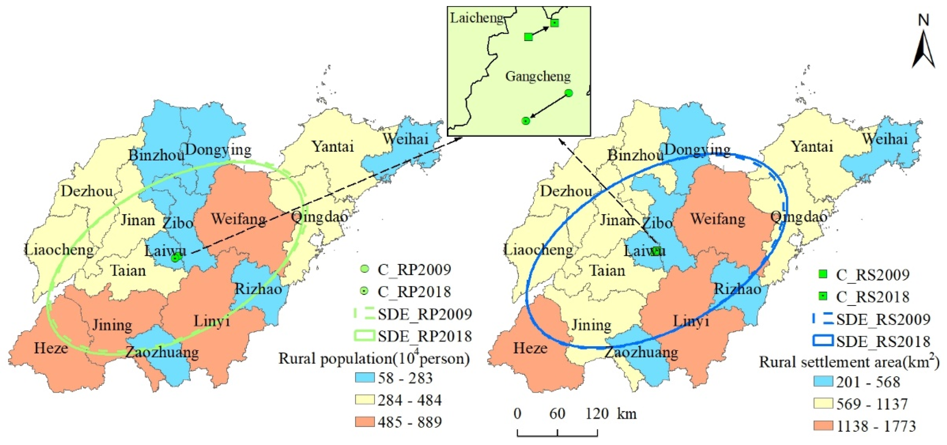
2.3.1. Standard Deviation Ellipse

Standard deviation ellipse is an extended application of the standard deviation of classical statistical methods in two-dimensional space, first proposed by Lefever almost a century ago [41,42]. This method conveys the spatial distribution characteristics of geographical elements through their dispersibility and directivity. The basic parameters of this standard deviation ellipse—its center, long axis, short axis, azimuth angle, and shape index—are quantitative reflections of the spatial distribution characteristics of geographical elements. The center denotes the center of gravity of geographical elements; azimuth angle represents the main trend direction of the distribution of geographical elements, namely the angle from due north clockwise to the long axis of the ellipse. This long axis corresponds to the dispersion degree of geographical elements in the main trend direction, while the short axis is that perpendicular to it. The shape index is the ratio of the short axis to the long axis, whose value is between 0 and 1; when closer to 1, the distribution shape is more circular, whereas, when closer to 0, the greater its flatness, and the more obvious is the directivity of the distribution of geographical elements. This paper uses standard deviation ellipse to quantitatively analyze the spatiotemporal characteristics of the rural population and rural settlements. The standard deviation ellipse was derived using the directional distribution function in ArcGIS software.

2.3.2. Per Capita Rural Settlement Area
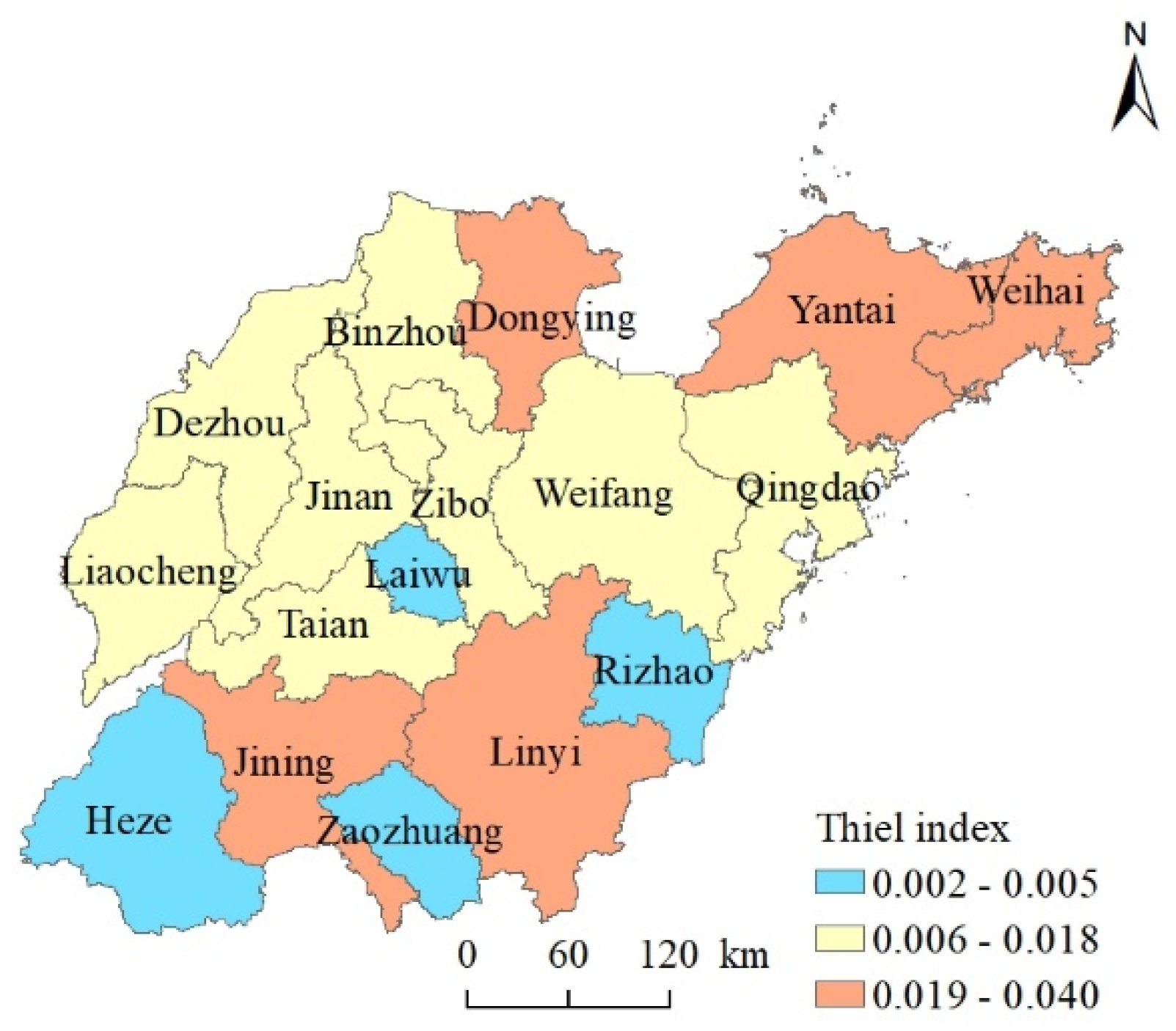
Per capita rural settlement area (PCRSA) is the most direct manifestation of the rural human–land relationship, which can reflect the intensive utilization level of rural settlements. This variable is calculated as follows:
P C R S A = R S A R P
where, RSA is the rural settlement area, and RP is the number of rural populations. According to the Town Planning Standards (GB50188-2007), the per capita rural settlement area should be less than 150 m2.

2.3.3. Theil Index

The Theil index was first proposed by Theil, in 1967, as a way to measure income differences between regions [43]. The larger the Thiel index, the greater the difference in income distribution and, conversely, the smaller the Thiel index, the more balanced the income distribution is. Compared with other similar measures, the Theil index has a key advantage: it can decompose the regional overall difference into intergroup vs. intragroup differences, and analyze the contribution of these two kinds of differences to the overall difference value [40]. Therefore, the Theil index was used here to measure the spatial matching degree between the rural population and rural settlements. This variable is calculated as follows.
T = T b + T w
T b = i = 1 n R S A i R S A · l n ( R S A i R S A / R P i R P )
T w = i = 1 n R S A i R S A · T i
T i = i = 1 n R S A i j R S A i · l n ( R S A i j R S A i / R P i j R P i )
R b = T b / T
where,   T is the overall Theil index of Shandong Province; T b and T w , respectively, indicate the inter- and intra-regional differences; T i denotes the Theil index of each city; R S A i j and R S A i represent the rural settlement area of each county and city, respectively; R P i j and R P i represent the rural population of each county and city, respectively; R S A and R P are the rural settlement area and rural population of Shandong Province, respectively; R b represents the intergroup contribution to the T variable.

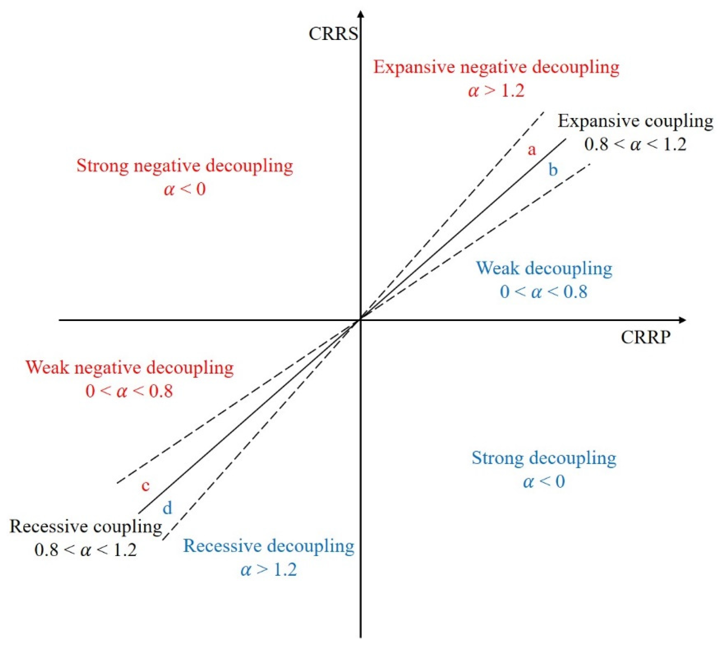
2.3.4. Tapio’s Elastic Decoupling Model

To investigate the decoupling between GDP and road traffic, Tapio constructed what is now known as Tapio’s elastic decoupling model, which is based on the concept of elasticity [44]. This model is simple to operate and easy to understand, and it has been widely used in many fields [45,46,47]. To accurately depict the relationship between changes to the rural population and rural settlements, Tapio’s elastic decoupling model was implemented here. The decoupling model has this formula:
α n + 1 = C R R S C R R P = ( R S A n + 1 R S A n ) / R S A n ( R P n + 1 R P n ) / R P n
where α n + 1 is the Tapio’s elasticity value in the years n + 1, and C R R S and CRRP are the rate of change of the rural settlement area and rural population, respectively. R S A n + 1 and R S A n , respectively, denote the rural settlement area in the years n + 1 and n, and, likewise, R P n + 1 and R P n for the rural population. According to the value of α n + 1 and the changing direction of the rural population and rural settlements, the relationship between these two aspects can be divided into 8 types: expansive negative decoupling, strong negative decoupling, weak negative decoupling, recessive decoupling, strong decoupling, weak decoupling, expansive coupling, and recessive coupling (Figure 3). Among them, expansion negative decoupling, strong negative decoupling, or weak negative decoupling would be beneficial for improving the intensive utilization level of rural settlements, whereas a weak decoupling, strong decoupling, or recessive decoupling will further intensify the extensive utilization degree of rural settlements.

3. Results

3.1. Spatiotemporal Characteristics of Rural Population and Rural Settlements

During the 2009–2018 period, the rural population of Shandong Province decreased from 68,119,600 in 2009 to 66,038,600 in 2018, a net reduction of 2,081,000 inhabitants. The change process can be divided into two stages: an increasing trend (i.e., 2009–2016) followed by a decreasing trend (i.e., 2016–2018) (Figure 4). Among the 17 prefectures, there were 9 cities (Weifang, Jining, Liaocheng, Yantai, Dezhou, Tai’an, Zibo, Weihai, and Laiwu) whose rural population declined, while the other 8 cities had an increase in their rural population. Compared with that of other regions, the rural populations of Linyi, Heze, Weifang, and Jining were significantly larger, at 8.72 million, 7.64 million, 6.99 million, and 6.62 million inhabitants, respectively (Figure 5). This was mainly driven by differences in topography, location, social and economic development, and industrial structure. The rural populations of Yantai, Qingdao, Liaocheng, Dezhou, Jinan, and Tai’an ranged from 284 million to 4.84 million. The rural populations of Weihai, Rizhao, Zaozhuang, Laiwu, Zibo, Binzhou, and Dongying were relatively small, and their administrative area is generally small. Weihai, Rizhao, Zaozhuang, Laiwu, and Zibo are mountainous and hilly areas, while Binzhou and Dongying lie in the lower reaches of the Yellow River, where the more salinized and alkaline lands invoke certain safety hazards.
The rural settlement area in Shandong Province did not decrease with a decrease in the rural population, but actually increased yearly, expanding from 13,387.33 km2 in 2009 to 14,613.20 km2 in 2018. In this respect, the rural settlement area in each of Shandong’s cities exhibited a steady growth trend (Figure 4).
Rural settlement is the spatial carrier of farmer’s productivity and living, and it is the product to meet the farmers’ production and living needs. Therefore, the rural population and rural settlements are highly correlated in quantity and highly consistent in their spatial distribution (Figure 5).
The rural settlement area of Linyi, Heze, and Weifang was larger than that of other cities, at 1647.33 km2, 1500.00 km2, and 1208.00 km2 in 2018, respectively. The number of cities with rural settlement areas of 569 to 1137 km2 is high, accounting for 47.06% of the total number of prefecture-level cities in Shandong Province, and they were mainly distributed in the west of Shandong (except Yantai and Qingdao). Most of those cities are located on the plains and sustain relatively large rural populations. The spatial distribution of cities having a rural settlement area of less than 568 km2 was relatively dispersed, and these included Weihai, Rizhao, Zaozhuang, Dongying, Zibo, and Laiwu. These cities have smaller administrative areas and more mountainous and hilly areas.
The results of the standard deviation ellipse show that the spatial distribution of rural population and rural settlements is highly consistent (Figure 5). Firstly, we can see that the spatial distribution range of the standard deviation ellipses of the rural population and rural settlements are basically the same. Secondly, the shape index of the standard deviation ellipse for the rural population and rural settlements is 0.54 and 0.55, respectively, indicating that their spatial distributions have pronounced directivity. Finally, the azimuths of the two are 60.29 and 61.23, respectively, with a difference of less than 1°, which further indicates that their spatial distribution directions were oriented southwest to northeast.
It is worth noting that, although the respective centers of the rural population and rural settlement area were located in the Gangcheng district of Laiwu city in both 2009 and 2018, they moved in opposite directions during the 2009–2018 period (Figure 5). The center of the rural population shifted 5931.48 km to the southwest, while that of rural settlement moved 3476.95 km to the northwest. This indicated a certain degree of spatial mismatch in the changes to rural population and rural settlements; however, their corresponding variation range was small. Hence, the consistency of their spatial distributions was only slightly reduced.

3.2. Relationship between Rural Population and Rural Settlements

3.2.1. Per Capita Rural Settlement Area

With the rapid development of urbanization, the rural population of Shandong Province decreased by 2.08 million, or 3.35%, but its rural settlement area increased by 1225.82 km2, or 9.16%. Thus, the per capita rural settlement area increased from 187.88 m2/person in 2009 to 212.18 m2/person, which exceeds the maximum national standard of 150 m2/person, and corresponds to an increasing trend.
In 2018, the per capita rural settlement area of all 17 prefecture-level cities of Shandong Province exceeded the above standard to some extent, by margins ranging from 17.57 to 255 m2 (Figure 6). The spatial distribution of per capita rural settlement areas has a pattern characterized by being high in the north and low in the south. The per capita rural settlement areas of most cities in the north of Shandong province were greater than 200 m2, especially in Dongying, Laiwu, and Weihai, where the per capita rural settlement area surpassed 300 m2. The terrain of northwestern Shandong is a plain with few topographic restrictions, and therefore the scale of rural settlement areas there is generally large, yielding a relatively high per capita area. The urbanization on Jiaodong Peninsula has been rapid, and massive portions of its rural population are moving from the countryside to cities. However, the lag in the withdrawal of rural settlements rendered its per capita rural settlement area relatively high. The per capita rural settlement area of cities in the south of Shandong Province was between 168 and 200 m2. Topographical constraints and the continued growth of the rural population accounted for the relatively low per capita rural settlement area in these areas.

3.2.2. Spatial Matching between Rural Population and Rural Settlements

Using the rural population and rural settlement data of 136 counties in 2009 and 2018, the Thiel index was calculated to determine the degree of spatial matching between the rural population and rural settlement area. These results showed a high spatial matching degree, with small regional differences, and no excessive concentration or uneven distribution. In addition, any regional differences were dominated by inter-regional differences. Specifically, the Thiel index in Shandong Province as a whole was small, but it showed a trend of increasing over time, rising from 0.12 in 2009 to 0.14 in 2018 (Table 1). The total Thiel index can be further decomposed into intragroup and intergroup differences; these both increased from 2009 to 2018. However, the contribution from the intragroup difference tended to increase over time, whereas that from the intergroup difference showed a decreasing trend; however, the former predominated and was the main source of the overall difference found, accounting for 88% of the T value. The intergroup difference reflects the difference among average levels of the spatial matching degree between the rural population and rural settlement area among cities, while the intragroup difference refers to the difference in those levels of districts and counties within the same city. Compared with those among cities, the differences in natural conditions, social and economic development level, and related policies are often smaller within the same city, and the production and life styles of its farmers are more similar. Therefore, the differences in the spatial matching degree between the rural population and rural settlement between districts and counties within a given city are relatively small and more consistent than among cities.
Spatially, the Thiel index was relatively high in cities located in northern Shandong (Figure 7). The Thiel index of cities in southern Shandong showed evidence of polarization, in that lower values (for Heze, Zaozhuang, and Rizhao) and higher values (for Jining and Linyi) are arranged alternately. The Thiel index of each city featured particular regional differences, however, it did not correspond fully with the location and level of socioeconomic development across space.

3.2.3. The Coupling Coordination Degree of Temporal Change in the Rural Populations and Rural Settlement Area

The per capita rural settlement area and spatial matching degree reflect the current characteristics or results of change in the rural human–land relationship, while Tapio’s decoupling model focuses on its process of change.
During 2009–2018, the relationship between the changes to the rural population and rural settlement consisted of three types: strong negative decoupling, expansive negative decoupling, and expansive coupling (Figure 8). Among them, the strong negative decoupling type dominated, characterizing 10 of the 17 cities (58.82%) that were mainly distributed in a southwest-to-northeast direction. In these 10 cities, the rural human–land relationship is unbalanced as there is a decrease in its rural population but an increase in its rural settlement area. Therefore, this change will further intensify the extensive use of rural settlements. Dongying, Jinan, Liaocheng, Rizhao, Linyi, and Zaozhuang all belong to the expansive negative decoupling type, and they are distributed on either side of the strong negative decoupling type. The rural population and rural settlement area in these areas both increased; however, the increasing speed of expansion of rural settlement area has overtaken the growth of the rural population, so their ratio was greater than 1.2. Consequently, this change will also aggravate the extensive utilization of rural settlements. Only the changes to the rural population and rural settlements in Heze showed a coordinated relationship. There was little difference found between the growth rate of the rural population and that of rural residential area in Heze city, but its rural settlement area expanded faster than its rural population. Hence, this change will also worsen the extensive use of rural settlements.

4. Discussion

4.1. Comparison with Relevant Studies

The Tapio’s decoupling model was mainly used in previous studies investigating the rural human–land relationship, to focus upon the change process and discuss the coordinated relationship between changes to the rural population and rural settlement area [10,11]. That model, however, calculates the ratio between the rate of change of rural population and rural settlements, which cannot reflect the current state of rural human–land relations [12,48]. Therefore, this paper’s research work broadens the study of the rural human–land relationship in several aspects. We not only pay attention to the change process, but also use the per capita rural settlement area and Theil index to analyze the current characteristics of the rural human–land relationship and spatial matching degree of the rural population and rural settlement area. Therefore, we quantitatively identified the characteristics of the rural human–land relationship according to these three complementary dimensions. In addition, when using Tapio’s decoupling model to analyze the coordination of the rural human–land relationship, we not only analyzed this relationship, but further divided its types into two categories: promoting intensive use and intensifying extensive use, which reflects the influence of the change of rural human-land relationship on its current situation.
The results for per capita rural settlement area show that the use of rural settlement is extensive and markedly exceeds the national standard. The Theil index results show that the spatial matching degree of rural population and rural settlements is high, with no discernable excessive concentration or uneven distribution. Combining the two, we can draw the conclusion that the extensive utilization of rural settlements is common to all regions in Shandong Province. The results of Tapio’s decoupling model demonstrate that the human–land changes are incongruous and exacerbate the extensive utilization of rural settlements. Compared with the results of previous relevant studies [10,11,12], our findings suggest that the extensive utilization of rural settlements has worsened. Therefore, quantitative identification of the rural human–land relationship according to the three dimensions provides a more accurate and comprehensive grasp of the characteristics of the rural human–land relationship, so as to timely adopt targeted strategies.

4.2. Understanding the Rural Human–Land Relationship

The results of standard deviation ellipse and Theil index revealed that the spatial distribution of the rural population and rural settlement area has a strong consistency, and the spatial matching degree of the two is high. The larger the rural population, the larger is the scale of rural settlement area, and vice versa. This indicates that the regional difference in rural settlement utilization is small, and the rural population is the main determinant of the scale of rural settlements. These findings are inconsistent with other research which found that altitude, slope, rainfall, and other environmental factors also influence the size of rural settlement in China [49]. However, this discrepancy is understandable. Compared with the impact of human populations, the effects of altitude, slope, rainfall, and other factors on rural settlements are marginal. Besides, when combined with the results of per capita rural settlement area, evidently the utilization of rural settlements in Shandong Province is generally extensive and inefficient.
Rural homestead is the main component of rural settlements and the most fundamental housing guarantee for farmers. China implements the rural homestead system of free acquisition and free use; this has ensured the basic rights and interests of farmers to the maximum extent possible. However, in the context of rapid urbanization and industrialization, due to the widening gap in development between urban and rural areas, many farmers have flooded into cities to work there. However, China’s urban–rural dual structure and household registration system make it impossible for most migrant workers to settle down in those cities [8,9]. Therefore, with this increase in their income, it is common for migrant workers to return to their hometowns to improve their houses or build new ones. Due to the lack of village planning in addition to supervision difficulties, as well as other reasons, this new housing is often located at the periphery of the original village [11,50]. Therefore, these new houses are built without demolishing the old ones, which leaves many houses in the village core sitting idle and abandoned, meaning that the extensive and inefficient utilization of rural settlements is a very common phenomenon. At the same time, rural areas are undergoing transformation, wherein secondary and tertiary industries are developing rapidly, so that new types of villages, such as those dominated by those industries, are now emerging, which raises the demand for construction land [28,51,52]. The expansion of rural industrial land is gradually becoming the main driver for the expansion of village construction land [51,52,53]. However, village planning currently does not take this into consideration.
The reasons for the imbalance in the spatiotemporal changes to rural population and rural settlement arise from the joint action of many factors. The rural population is now mobile, and this mobility has the characteristics of initiative, flexibility, and profitability. Against the background of uneven development between urban and rural areas [8,9,53], to pursue better employment opportunities and gain higher incomes, the rural population has taken the initiative and made a rational choice to work in cities. In so doing, the rural population can flexibly choose when and where to work, and have other options as well. By contrast, rural settlements, as real estate, are immovable and their changes are mostly passive, lagged, and consumptive. Rural settlements are not only the basic requirement for living and working in peace and contentment but also symbolize the wealth and social status of the rural population. Moreover, rural settlements are an important guarantee for migrant workers to return to the countryside, which fosters in them a sense of homesickness while away in the cities. Furthermore, demolishing rural settlements consumes financial resources [11], but an incentive mechanism for rural homestead withdrawal is lacking. Therefore, even if rural settlements have been idle or abandoned, farmers harbor no initiative to demolish their houses [54]. Another key reason worth mentioning is that the transfer of a rural homestead is limited to other residents of the same village, which hinders realization of the asset function of that rural homestead, thereby further hampering the revitalizing and utilizing of rural homesteads [10,51,55].

4.3. Policy Implications

The utilization of rural settlements in Shandong is generally extensive and inefficient. To achieve the intensive and efficient use of its rural settlements, as well as to adjust the structure of its urban and rural construction land, optimize its rural production and living and ecological space, improve its rural living environment, and help achieve its rural revitalization, we have put forward some policy suggestions below.

4.3.1. Rural Homestead Withdrawal and Transfer

Free acquisition and free use are the basic traits of China’s rural homestead system. These characteristics have made the “homestead area exceeding the standard” and “one farm household owns several rural plots of housing land” common phenomena. Yet, in the absence of a rural homestead withdrawal mechanism and the restriction of rural homestead transfers, occupying rural settlements may be the only rational option for farmers [54]. This, not surprisingly, leads to the continuous expansion of per capita rural settlement area and the inefficient use and waste of rural settlements on the landscape.
Villagers should be encouraged to withdraw from their rural homestead voluntarily with compensation, on the premise of ensuring that each household has a residence. Furthermore, the standards for paid use should be transparent and strictly enforced, and for that part exceeding the specified area, it shall be paid for use and charged in a stepwise manner, thus forcing the homestead’s withdrawal. To be specific, attractive withdrawal compensation standards should be formulated with explicit reference to the current land expropriation price of the area, as this would stimulate the enthusiasm of farmers to gradually withdraw from idle and abandoned homesteads. In addition, the number, area, and user status of a homestead should be fully taken into account when setting such standards for its paid use. For example, for the part exceeding the prescribed standard of 1–50 m2, a suitable charge could be 10 yuan/m2/year, whose rate would be increased by 5 yuan for each additional 50 m2. Non-residents of the village who own and use the rural homestead ought to be charged at a higher rate; for example, according to the actual floor space, they could be charged at a rate of 50 yuan/m2.
Furthermore, improvements to the rural homestead transfer process should be explored piecemeal. Rural homestead transfer is undoubtedly a crucial way to realize the capital function of a rural homestead. However, hidden transactions among rural homesteads are common, especially in the more economically developed areas [50]. Therefore, we suggest that the homestead transfer should expand its scope, by not limiting it to village residents. Besides, the work of confirming the right, registration, and issue certification is the basis of rural homestead transfer. Therefore, it is necessary to explore homestead transfer in an orderly manner in those areas where conditions permit it, with respect to the confirmation of ownership, registration, and certificate issuance.

4.3.2. Cross-Regional “Increasing Versus Decreasing Balance”

In rural areas where the human–land relationship is unbalanced, especially those with serious hollowing out and many homesteads sitting idle and abandoned, land consolidation project measures should be pursued. This would reclaim the rural homestead into cultivated land and ecological land after the rural homestead is withdrawn with compensation, so as to ensure food security and improve ecosystem value. However, the reclamation of rural settlements requires much money, which is often lacking in rural areas with an unbalanced human–land relationship. Nonetheless, the cities have a large demand for construction land and sufficient funds, but the new construction land quota is limited. For this reason, China has creatively put forward the “increasing versus decreasing balance” policy.
However, implementation of this policy is often limited to a specific county or city. It is not difficult to imagine that, despite the many idle and abandoned rural homesteads for consolidation in areas with rapidly decreasing rural populations, their urban urbanization level is often low and their demand for construction land is insufficient [55]. Similarly, in regions with a high level of urbanization, the demand for construction land is relatively large, but the level of urban–rural integration is relatively high, and therefore the potential of rural settlements’ consolidation is relatively small. Therefore, the balance between urban and rural construction land increase and decrease may not be realized in the same way in every county or city [11,50].
Cross-regional “increasing versus decreasing balance” may thus be the better choice in the future. In areas with strong demand for construction land and with the sufficient funds, but lacking the reclamation indicators of rural settlements, cross-regional project areas could be formed together with those rural areas already having sufficient reclamation indicators of rural settlements yet lacking funds.

4.3.3. Rural Revitalization and Village Planning

Rural area is threatened by population reductions and an imbalanced human–land relationship, so that rural decline is worsening and creating a worrisome situation [2,3]. To ameliorate this, China has put forward a strategy of rural revitalization [2,8]. However, given the huge innate differences in the natural resource endowment among different regions in China, not all villages can expect to be revitalized. Villages located in those areas with poor living conditions, a fragile ecological environment, frequent natural disasters, or major safety hazards, as well as villages with especially serious population losses, should probably be demolished and removed. In this way, the safety of life and property of residents can be guaranteed, the living environment of the other villages can be improved, and the overall construction cost of public service facilities can be reduced. Small villages with a scattered layout, extensive utilization, and no development potential should be dismantled, and the rural population should be persuaded to live in central villages that are large in scale and have strong vitality. In the construction of the new village, the local per capita land use standards should be strictly implemented and the production and living ecological space should be rationally distributed. Villages with prosperous industries and a strong population gathering capacity are the focus of rural revitalization. For this type of village to thrive, the village development needs should be fully considered in all phases of village planning, the index of rural industrial construction land should be reserved and guaranteed, and the diversified supply mode of rural industrial land should be established.

4.4. Recommendations for Future Study

First of all, due to the lack of comparable data in the long time series, this paper could only analyze the rural human–land relationship during a single decade (2009–2018). Using multi-period data would provide more convincing evidence to robustly compare the temporal and spatial characteristics of the rural human–land relationship. Secondly, this paper takes the rural settlements as a whole when analyzing rural human–land relationship. On this basis, the relationship between the change in internal structure and the function of rural settlements and rural population could be further analyzed with input from internal land-use data of the rural settlements, which would help uncover the mechanisms underpinning the human–land relationship more clearly. Finally, there is a correlated flow of resources and factors between urban and rural areas, whose consideration would enable a comprehensive study of the urban–rural human–land relationship as a promising future research direction.
The research framework and method proposed in this paper can be applied to the measurement of the rural human–land relationship in other countries. By improving the level of intensive use of rural settlement, as well as the spatial matching degree and the synchronous change between rural population and rural settlement area, the rational use of rural land resources can be realized, and the sustainable development of rural areas can be promoted.

5. Conclusions

Based on the data of rural population and rural settlement area at the county level in 2009 and 2018, we comprehensively analyzed the rural human–land relationship from three aspects: the level of intensive utilization of rural settlement, the spatial matching degree of rural population and rural settlement area, and the coordination degree of change between the rural population and rural settlement area. The results show that the rural settlement area generally exceeds the national standard and extensive use of rural settlement land is a common phenomenon. Besides, the change in rural population and rural settlement area presents an uncoordinated situation, dominated by the strong negative decoupling type, which further aggravates the extensive utilization of rural settlement. Compared with the results of related studies, our findings indicate that waste in rural settlements is more serious and that corresponding measures are urgently needed. In order to curb the waste of rural settlement land, we put forward some policy suggestions, such as paying for the use of homestead, voluntary paying for the withdrawal of homestead, cross-regional “increasing versus decreasing balance”, and making village planning by category.

Author Contributions

G.D. contributed to all aspects of this work; W.Z. contributed to the investigation and resources; X.X. contributed to the original draft preparation, supervision and funding acquisition; K.J. contributed to the conceptualization, original draft preparation and supervision. All authors have read and agreed to the published version of the manuscript.

Funding

This research was funded by the National Natural Science Foundation of China, grant number 41801173, Doctor foundation of Shandong Jianzhu University, grant number XNBS1803, and by a grant from State Key Laboratory of Resources and Environmental Information System.

Data Availability Statement

The data presented in this study are available on request from the author.

Conflicts of Interest

The authors declare no conflict of interest.

References

  1. Malakoff, D.; Wigginton, N.S.; Fahrenkamp-Uppenbrink, J.; Wible, B. Use our infographics to explore the rise of the urban planet. Science. 2016. Available online: http://www.sciencemag.org/news/2016/05/use-our-infographics-explore-rise-urban-planet (accessed on 21 September 2021).
  2. Liu, Y.S.; Li, Y.H. Revitalize the world’s countryside. Nature 2017, 548, 275–277. [Google Scholar] [CrossRef]
  3. Li, Y.; Westlund, H.; Liu, Y. Why some rural areas decline while some others not: An overview of rural evolution in the world. J. Rural. Stud. 2019, 68, 135–143. [Google Scholar] [CrossRef]
  4. Chi, G.Q.; Ho, H.C. Population stress: A spatiotemporal analysis of population change and land development at the county level in the contiguous United States 2001. Land Use Policy 2018, 70, 128–137. [Google Scholar] [CrossRef]
  5. Tong, Q.; Qiu, F. Population growth and land development: Investigating the bi-directional interactions. Ecol. Econ. 2020, 169, 106505. [Google Scholar] [CrossRef]
  6. Bai, X.M.; Shi, P.J.; Liu, Y.S. Realizing China’s urban dream. Nature 2014, 509, 158–160. [Google Scholar] [CrossRef] [Green Version]
  7. Tan, M.H.; Li, X.B.; Xie, H.; Lu, C.H. Urban land expansion and arable land loss in China—A case study of Beijing-Tianjin-Hebei region. Land Use Policy 2005, 22, 187–196. [Google Scholar] [CrossRef]
  8. Gao, J.; Liu, Y.; Chen, J. China’s initiatives towards rural land system reform. Land Use Policy 2020, 94, 104567. [Google Scholar] [CrossRef]
  9. Liu, Y.S. Introduction to land use and rural sustainability in China. Land Use Policy 2018, 74, 1–4. [Google Scholar] [CrossRef]
  10. Song, W.; Liu, M. Assessment of decoupling between rural settlement area and rural population in China. Land Use Policy 2014, 39, 331–341. [Google Scholar] [CrossRef]
  11. Cai, E.; Chen, W.; Wei, H.; Li, J.; Wang, H.; Guo, Y.; Feng, X. The coupling characteristics of population and residential land in rural areas of China and its implications for sustainable land use. Sustain. Dev. 2019, 28, 646–656. [Google Scholar] [CrossRef]
  12. Zhu, Z.; Kong, X.; Li, Y. Identifying the Static and dynamic relationships between rural population and settlements in Jiangsu Province, China. Chin. Geogr. Sci. 2020, 30, 810–823. [Google Scholar] [CrossRef]
  13. Long, H.; Liu, Y.; Li, X.; Chen, Y. Building new countryside in China: A geographical perspective. Land Use Policy 2010, 27, 457–470. [Google Scholar] [CrossRef]
  14. Huang, Q.; Song, W.; Song, C. Consolidating the layout of rural settlements using system dynamics and the multi-agent system. J. Clean. Prod. 2020, 274, 123150. [Google Scholar] [CrossRef]
  15. Liu, Y.; Yang, Y.; Li, Y.; Li, J.T. Conversion from rural settlements and arable land under rapid urbanization in Beijing during 1985. J. Rural. Stud. 2017, 51, 141–150. [Google Scholar] [CrossRef]
  16. Su, S.; Zhang, Q.; Zhang, Z.; Zhi, J.; Wu, J. Rural settlement expansion and paddy soil loss across an ex-urbanizing watershed in eastern coastal China during market transition. Reg. Environ. Chang. 2011, 11, 651–662. [Google Scholar] [CrossRef]
  17. Li, H.; Song, W. Expansion of rural settlements on high-quality arable land in Tongzhou district in Beijing, China. Sustainability 2019, 11, 5153. [Google Scholar] [CrossRef] [Green Version]
  18. Zhang, Y.; Li, X.; Song, W. Determinants of cropland abandonment at the parcel, household and village levels in mountain areas of China: A multi-level analysis. Land Use Policy 2014, 41, 186–192. [Google Scholar] [CrossRef]
  19. Han, Z.; Song, W. Abandoned cropland: Patterns and determinants within the Guangxi Karst Mountainous Area, China. Appl. Geogr. 2020, 122, 102245. [Google Scholar] [CrossRef]
  20. Wang, Y.; Li, X.; Xin, L.; Tan, M. Farmland marginalization and its drivers in mountainous areas of China. Sci. Total. Environ. 2020, 719, 135132. [Google Scholar] [CrossRef]
  21. Liu, Y.S.; Liu, Y.; Chen, Y.F.; Long, H.L. The process and driving forces of rural hollowing in China under rapid urbanization. J. Geogr. Sci. 2010, 20, 876–888. [Google Scholar] [CrossRef]
  22. Dong, G.; Ge, Y.; Jia, H.; Sun, C.; Pan, S. Land use multi-suitability, land resource scarcity and diversity of human needs: A new framework for land use conflict identification. Land 2021, 10, 1003. [Google Scholar] [CrossRef]
  23. Jiang, S.; Meng, J.; Zhu, L. Spatial and temporal analyses of potential land use conflict under the constraints of water resources in the middle reaches of the Heihe River. Land Use Policy 2020, 97, 104773. [Google Scholar] [CrossRef]
  24. Kim, I.; Arnhold, S. Mapping environmental land use conflict potentials and ecosystem services in agricultural watersheds. Sci. Total. Environ. 2018, 630, 827–838. [Google Scholar] [CrossRef]
  25. Dong, G.L.; Xu, E.Q.; Zhang, H.Q. Spatiotemporal Variation of Driving Forces for Settlement Expansion in Different Types of Counties. Sustainability 2016, 8, 39. [Google Scholar] [CrossRef] [Green Version]
  26. Li, H.; Song, W. Pattern of spatial evolution of rural settlements in the Jizhou District of China during 1962. Appl. Geogr. 2020, 122, 102247. [Google Scholar] [CrossRef]
  27. Tan, M.; Li, X. The changing settlements in rural areas under urban pressure in China: Patterns, driving forces and policy implications. Landsc. Urban Plan. 2013, 120, 170–177. [Google Scholar] [CrossRef]
  28. Tian, G.; Qiao, Z.; Gao, X. Rural settlement land dynamic modes and policy implications in Beijing metropolitan region, China. Habitat Int. 2014, 44, 237–246. [Google Scholar] [CrossRef]
  29. Qu, Y.B.; Jiang, G.H.; Yang, Y.T.; Zheng, Q.Y.; Li, Y.L.; Ma, W.Q. Multi-scale analysis on spatial morphology differentiation and formation mechanism of rural residential land: A case study in Shandong Province, China. Habitat Int. 2018, 71, 135–146. [Google Scholar]
  30. Long, H.; Liu, Y.; Wu, X.; Dong, G. Spatio-temporal dynamic patterns of farmland and rural settlements in Su–Xi–Chang region: Implications for building a new countryside in coastal China. Land Use Policy 2009, 26, 322–333. [Google Scholar] [CrossRef]
  31. Qu, Y.; Jiang, G.; Zhao, Q.; Ma, W.; Zhang, R.; Yang, Y. Geographic identification, spatial differentiation, and formation mechanism of multifunction of rural settlements: A case study of 804 typical villages in Shandong Province, China. J. Clean. Prod. 2017, 166, 1202–1215. [Google Scholar] [CrossRef]
  32. Ma, W.; Jiang, G.; Li, W.; Zhou, T.; Zhang, R. Multifunctionality assessment of the land use system in rural residential areas: Confronting land use supply with rural sustainability demand. J. Environ. Manag. 2019, 231, 73–85. [Google Scholar] [CrossRef]
  33. Tian, Y.; Liu, Y.; Kong, X. Restructuring rural settlements based on mutualism at a patch scale: A case study of Huangpi District, central China. Appl. Geogr. 2018, 92, 74–84. [Google Scholar] [CrossRef]
  34. Ma, W.; Jiang, G.; Zhang, R.; Li, Y.; Jiang, X. Achieving rural spatial restructuring in China: A suitable framework to understand how structural transitions in rural residential land differ across peri-urban interface? Land Use Policy 2018, 75, 583–593. [Google Scholar] [CrossRef]
  35. Long, H.; Li, Y.; Liu, Y.; Woods, M.; Zou, J. Accelerated restructuring in rural China fueled by ‘increasing vs. decreasing balance’ land-use policy for dealing with hollowed villages. Land Use Policy 2012, 29, 11–22. [Google Scholar] [CrossRef]
  36. Tu, S.; Long, H.; Zhang, Y.; Ge, D.; Qu, Y. Rural restructuring at village level under rapid urbanization in metropolitan suburbs of China and its implications for innovations in land use policy. Habitat Int. 2018, 77, 143–152. [Google Scholar] [CrossRef]
  37. Long, H.; Zou, J.; Pykett, J.; Li, Y. Analysis of rural transformation development in China since the turn of the new millennium. Appl. Geogr. 2011, 31, 1094–1105. [Google Scholar] [CrossRef]
  38. Luo, J.; Xing, X.; Wu, Y.; Zhang, W.; Chen, R.S. Spatio-temporal analysis on built-up land expansion and population growth in the Yangtze River Delta Region, China: From a coordination perspective. Appl. Geogr. 2018, 96, 98–108. [Google Scholar] [CrossRef]
  39. Li, Z.; Luan, W.; Zhang, Z.; Su, M. Relationship between urban construction land expansion and population/economic growth in Liaoning Province, China. Land Use Policy 2020, 99, 105022. [Google Scholar] [CrossRef]
  40. Li, Y.; Kong, X.; Zhu, Z. Multiscale analysis of the correlation patterns between the urban population and construction land in China. Sustain. Cities Soc. 2020, 61, 102326. [Google Scholar] [CrossRef]
  41. Lefever, D.W. Measuring Geographic Concentration by Means of the Standard Deviational Ellipse. Am. J. Sociol. 1926, 32, 88–94. [Google Scholar] [CrossRef]
  42. Wang, B.; Shi, W.; Miao, Z. Confidence Analysis of Standard Deviational Ellipse and Its Extension into Higher Dimensional Euclidean Space. PLoS ONE 2015, 10, e0118537. [Google Scholar] [CrossRef] [PubMed]
  43. Theil, H. Economics and Information Theory; North Holland Publishing: Amsterdam, The Netherlands, 1967. [Google Scholar]
  44. Tapio, P. Towards a theory of decoupling: Degrees of decoupling in the EU and the case of road traffic in Finland between 1970 and and 2001. Transp. Policy 2005, 12, 137–151. [Google Scholar] [CrossRef] [Green Version]
  45. Zhang, M.; Li, H.; Su, B.; Yang, X. Using a new two-dimensional decoupling model to evaluate the decoupling state of global energy footprint. Sustain. Cities Soc. 2020, 63, 102461. [Google Scholar] [CrossRef]
  46. Luo, H.; Li, L.; Lei, Y.; Wu, S.; Yan, D.; Fu, X.; Luo, X.; Wu, L. Decoupling analysis between economic growth and resources environment in Central Plains Urban Agglomeration. Sci. Total. Environ. 2021, 752, 142284. [Google Scholar] [CrossRef] [PubMed]
  47. Hu, M.; Li, R.; You, W.; Liu, Y.; Lee, C.-C. Spatiotemporal evolution of decoupling and driving forces of CO2 emissions on economic growth along the Belt and Road. J. Clean. Prod. 2020, 277, 123272. [Google Scholar] [CrossRef]
  48. Li, M.; Shi, Y.; Duan, W.; Chen, A.; Wang, N.; Hao, J. Spatiotemporal decoupling of population, economy and construction land changes in hebei province. Sustainability 2019, 11, 6794. [Google Scholar] [CrossRef] [Green Version]
  49. Tian, G.; Qiao, Z.; Zhang, Y. The investigation of relationship between rural settlement density, size, spatial distribution and its geophysical parameters of China using Landsat TM images. Ecol. Model. 2012, 231, 25–36. [Google Scholar] [CrossRef]
  50. Zhu, S.; Kong, X.; Jiang, P. Identification of the human-land relationship involved in the urbanization of rural settlements in Wuhan city circle, China. J. Rural. Stud. 2020, 77, 75–83. [Google Scholar] [CrossRef]
  51. Zhang, C.; Kuang, W.; Wu, J.; Liu, J.; Tian, H. Industrial land expansion in rural China threatens environmental securities. Front. Environ. Sci. Eng. 2020, 15, 13. [Google Scholar] [CrossRef]
  52. Zhu, F.; Zhang, F.; Li, C.; Zhu, T. Functional transition of the rural settlement: Analysis of land-use differentiation in a transect of Beijing, China. Habitat Int. 2014, 41, 262–271. [Google Scholar] [CrossRef]
  53. Kuang, W.; Liu, J.; Dong, J.; Chi, W.; Zhang, C. The rapid and massive urban and industrial land expansions in China between 1990 and 2010: A CLUD-based analysis of their trajectories, patterns, and drivers. Landsc. Urban Plan. 2016, 145, 21–33. [Google Scholar] [CrossRef]
  54. Kong, X.; Liu, Y.; Jiang, P.; Tian, Y.; Zou, Y. A novel framework for rural homestead land transfer under collective ownership in China. Land Use Policy 2018, 78, 138–146. [Google Scholar] [CrossRef]
  55. Li, Y.; Liu, Y.; Long, H.; Cui, W. Community-based rural residential land consolidation and allocation can help to revitalize hollowed villages in traditional agricultural areas of China: Evidence from Dancheng County, Henan Province. Land Use Policy 2014, 39, 188–198. [Google Scholar] [CrossRef]
Figure 1. Location of Shangdong Province, China.
Land 10 01086 g001
Figure 2. Research framework and methodology used in this study.
Land 10 01086 g002
Figure 3. The eight types of rural human–land relationship examined in this study. Notes: CRRS is the change rate of rural settlement area, while CRRP is the change rate of the rural population. Here, a and d indicate the subtypes of expansive coupling and recessive decoupling with 1 < α < 1.2, respectively; correspondingly, the b and c indicate the subtypes of expansive coupling and recessive decoupling with 0.8 < α < 1, respectively. The red font indicates the more extensive use of rural settlements, and the blue font indicates the more intensive use of rural settlements.
Land 10 01086 g003
Figure 4. Temporal variation in the rural population size and rural settlement area.
Land 10 01086 g004
Figure 5. Spatial characteristics of the rural population and rural settlements. Notes: C_RP2009 and C_RP2018 are the center of the rural population in 2009 and 2018, respectively. SDE_RP2009 and SDE_RP2018 are the standard deviation ellipse of the rural population in 2009 and 2018, respectively. C_RS2009 and C_RS2018 are the center of the rural settlement area in 2009 and 2018, respectively. SDE_RS2009 and SDE_RS2018 are the standard deviation ellipse of the rural settlement area in 2009 and 2018, respectively.
Land 10 01086 g005
Figure 6. Spatial distribution of per capita rural settlement area in 2018.
Land 10 01086 g006
Figure 7. Spatial distribution of the Thiel index in 2018.
Land 10 01086 g007
Figure 8. Spatial distribution of three types of rural human–land relationship.
Land 10 01086 g008
Table 1. The results for the Theil index.
YearTheil IndexContribution
TTwTbRwRb
20090.120.010.110.090.91
20180.140.020.120.120.88
Notes: T, Tw, and Tb are the total difference, intragroup difference, and intergroup difference, respectively. Rw and Rb are the respective contributions from the intragroup and intergroup differences.
Publisher’s Note: MDPI stays neutral with regard to jurisdictional claims in published maps and institutional affiliations.

