Review

Evaluating Land Suitability and Potential Climate Change Impacts on Alfalfa (Medicago sativa) Production in Ethiopia

1
International Center for Tropical Agriculture (CIAT), Nairobi P.O. Box 823-00621, Kenya
2
Formation Environmental LLC, 1631 Alhambra Blvd, Sacramento, CA 95816, USA
3
Department of Ecosystem Science and Management, Texas A&M University, College Station, TX 77843, USA
4
Climate Change, Agriculture and Food Security, Addis Ababa P.O. Box 5689, Ethiopia
5
World Agroforestry Centre (ICRAF), United Nations Avenue, Nairobi P.O. Box 30677-00100, Kenya
6
Texas AgriLife Research, Temple, TX 76502, USA
*
Author to whom correspondence should be addressed.
Atmosphere 2020, 11(10), 1124; https://doi.org/10.3390/atmos11101124
Submission received: 30 September 2020 / Revised: 13 October 2020 / Accepted: 14 October 2020 / Published: 19 October 2020
(This article belongs to the Special Issue Climate Change and Its Impact on Crops)

Abstract

:
Ethiopia has the largest livestock population in Africa with 35 million tropical livestock units. The livestock system relies on natural open grazing which is affected by frequent droughts. However, little research exists that studies the suitability of the biophysical environment for fodder production and the risks due to climate change. The main objectives of the study are to evaluate the potential effects of climate change on land suitability for alfalfa production in Ethiopia and to assess the extent of irrigation requirements for alfalfa growing under the adverse climate change projections. The impact of climate change on land suitability for alfalfa was evaluated using projected changes in rainfall and temperature based on three global circulation models (CCSM4, HadGEM2-AO, and MIROC5). A multi-criteria evaluation in GIS that uses biophysical, climatic and topography factors was applied to identify the suitable land. The highly suitable area under current climate scenarios covered ~472,000 km2, while moderately suitable and marginally suitable covered ~397,000 km2 and ~16,200 km2, respectively. The projected climate alters the suitable land for fodder production across Ethiopia. Expansion of suitable land occurred in the highlands where climate scenarios predict an increase in temperature and precipitation. Dryland regions showed a rainfall deficit for the three model projections. The research provides guidelines for growing alfalfa in Ethiopia considering ecological and climatic variability.

1. Introduction

Ethiopia has the largest livestock population in Africa estimated at 35 million tropical livestock units (TLU). This includes 59.5 million cattle, 42 million sheep and goats, 56.53 million poultry, and 1 million camels [1]. The livestock sector contributes significant amount to the country’s economy accounting for about 15% of export earnings and 36% of the agricultural GDP [2]. The majority of the livestock herds are located in arid and semi-arid areas [3,4,5], where largely (~30–40%) owned by resource-pastoralist communities [6] who use traditional extensive means of production (e.g., open grazing).
Livestock production is likely to be adversely affected by climate change and variability, which are highly linked with food security and water availability. Evidence is accruing that the effects of climate change on livestock will probably manifest through the increasing frequency and intensity of extreme events and the temporal and spatial extent of climate variability. The potential impacts of climate change on livestock include changes in production and quality of feed crop and forage, water availability, animal health and growth and productivity [7,8,9].
Climate variability and extreme weather events such as frequent heat stress and drought have been critically affecting the quantity and quality of forage production in several parts of Ethiopia [10,11,12], which has hampered the productivity of the livestock sector and livelihoods of the smallholder pastoralists [10,11]. For example, decreases in pasture production and water stress weaken the productivity of the livestock sector through direct (e.g., increased herd mortality) and indirect (e.g., low quality and quantity of milk and meat production) methods, which thereby impact ability to generate income [13]. Kassahun [14] reported that pastoralists suffered up to 80% livestock herd loss due to drought in eastern Ethiopia. Desta and Coppock [15] reported that about 45 million U.S. dollar revenue lost due to recurrent drought in southern Ethiopia for the periods 1983–1985 and 1991–1993.
Megersa, Markemann [13] indicated that drought occurs at least once in every 8.4 years in southern Ethiopia and could be further exacerbated by climate change. Therefore, the dependence of pastoral communities on the natural pasture for livestock feed may not be a sustainable practice to manage climatic risks and build resilience in the pastoralist community and smallholder farmers in the region. Livestock producers should follow an adaptive management approach such as using irrigated and drought resistance fodder to cope with climate variability, and thereby increase the production of meat and milk [16,17].
The first step for an adaptive fodder production system may warrant estimating the potential suitable land, as well as estimating how this potential land will be impacted in the future with climate change [18]. Such land suitability analysis can help to identify areas that are productive and can be sustainably irrigated to cultivate forage crops in a productive manner [19] considering both biophysical and socio-economic factors (e.g., temperature, precipitation, elevation, soil, access to market, population density, etc.) to improve agricultural value chain and business [20,21,22]. Assessment of biophysical and climatic conditions enable estimating the range of potential suitable areas for agriculture use, [23], which could be further refined based on socio-economic and cultural limitations. Therefore, land suitability analyses based on biophysical factors provide a preliminary opportunity to examine the qualities of the land unit and whether it matches the biophysical requirements to support a productive crop or fodder cultivation. Therefore this study aimed at evaluating the potential impact of climate change on land suitability for alfalfa production in Ethiopia.
Analytical hierarchy process (AHP) and multi criteria evaluation (MCE) with geographic information systems (GIS) have been used to evaluate crop growth variables and weigh their importance for optimal growth conditions [21,23,24]. The integration of MCE within a GIS environment helps to facilitate developing suitability maps, and thereby enhance the decision-making process [25]. Some studies applied MCE and AHP techniques for land suitability analysis for generic crop production using historical climatic conditions [23,26,27]. This study applied AHP and an MCE GIS environment to define the suitability of land areas for alfalfa (Medicago sativa) fodder production for the current and projected climate scenarios in Ethiopia. The specific objectives were developing a suitability map for alfalfa (Medicago sativa) production based on biophysical and climate factors and identifying areas that may potentially change suitability due to climate change and require supplemental irrigation under present and future climate scenarios in Ethiopia.

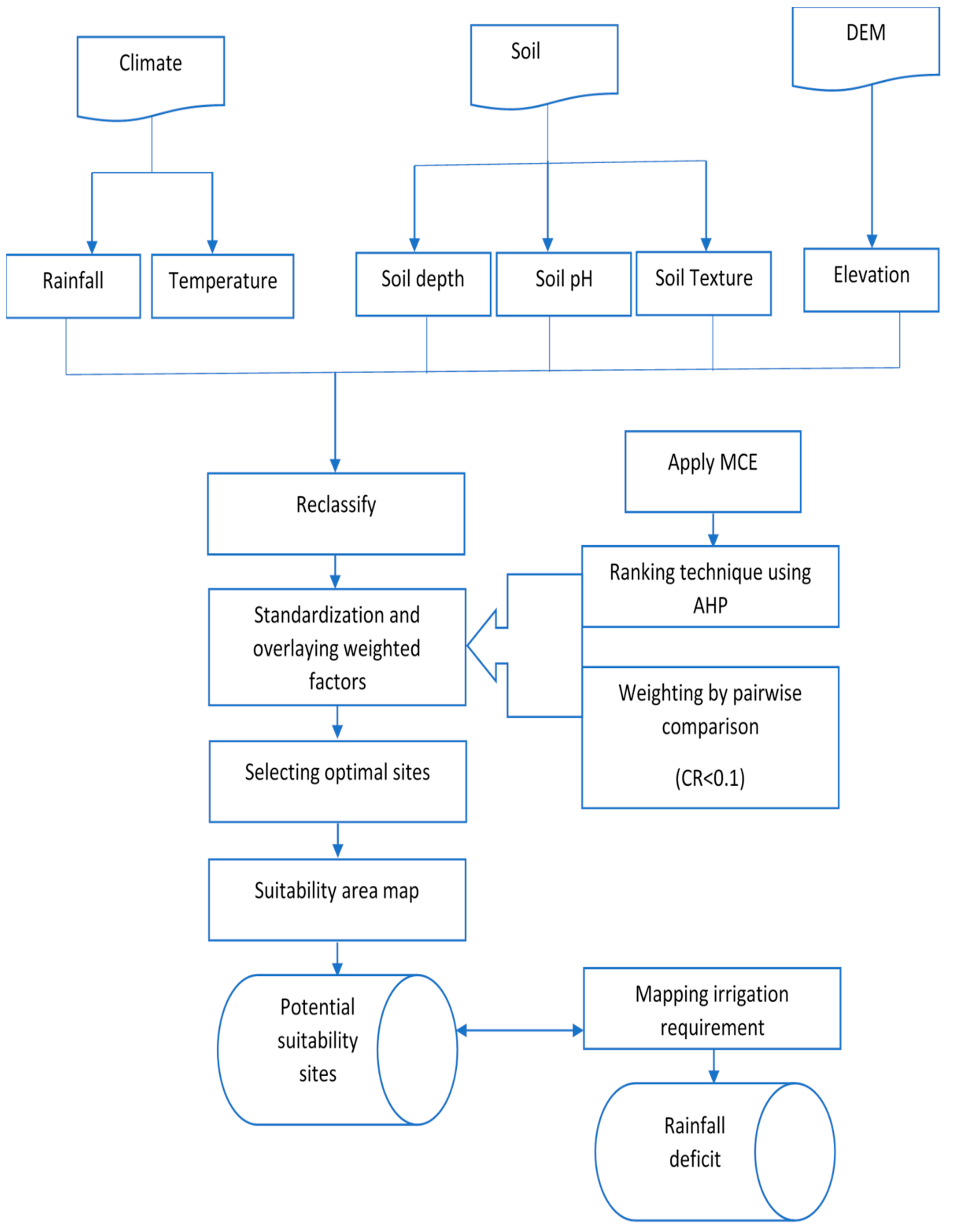
2. Data and Methodology

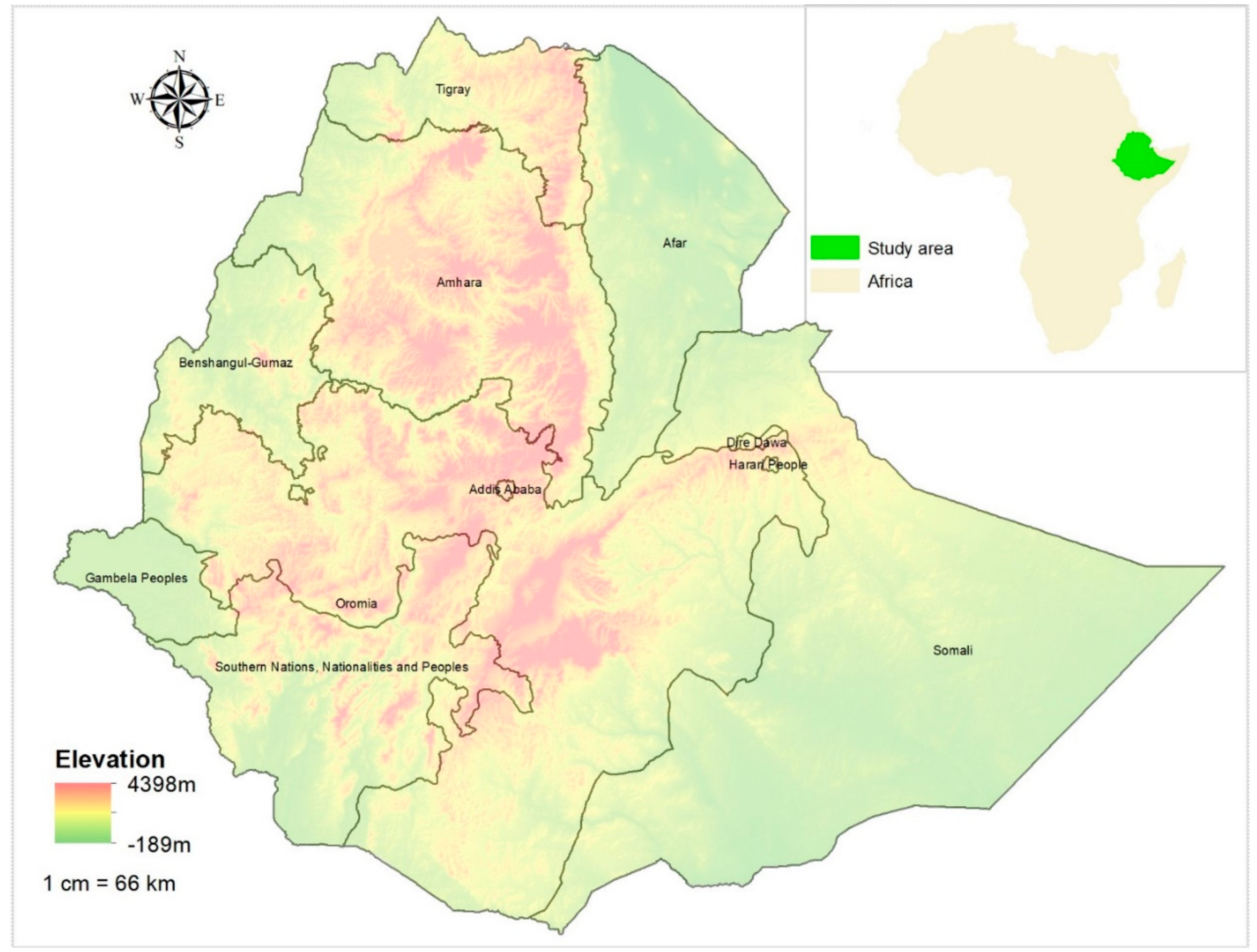
2.1. Study Area and Data

This study was conducted in Ethiopia located between 3°00′ to 15°00′ N and 32°00′ to 48°00′ E in the eastern part of Africa (Figure 1). Ethiopia has a tropical climate and rainfall that has high spatial and temporal variability. The highland areas receive moderate amounts of rainfall (~1200 mm per annum) with minimal temperature variation while the lowland regions receive less than 500 mm per year with a much higher temperature variation [27]. The Ethiopian highlands are areas that have an elevation above 1500 m.a.s.l. The highlands are divided into northwestern and southeastern portions by the Ethiopian Valley Rift system [28].

2.1.1. Historical and Future Climate Data

In this study, the WorldClim data layers were used for representation of historical climate across Ethiopia because of its high spatio-temporal resolution and length of record [1,2,3]. The WorldClim raster data layers are publicly available, the data were derived through interpolation of average monthly climate data covering the period of 1970 to 2000 from weather stations [29]. The World Meteorological Organization recommends using at least 30 years of climate record for climate change related studies [4]. Precipitation, temperature, and elevation data are extracted from the WorldClim data and a simple statistical analysis was performed on the temperature and precipitation data to estimate the monthly and annual means of temperature and precipitation for the study area. Table 1 presents the description of the factors considered to conduct land suitability analysis with their respective source and spatial resolution. The framework for the suitability analysis is presented in Figure 2.
The WorldClim temperature layers in the dataset were in a generic grid format, which was converted to Celsius according to WorldClim recommendation of dividing by 10 to match the Ecocrop requirement. Average monthly temperature range map was reclassified based on the average maximum and minimum monthly pixel values for each monthly image. The annual average temperature raster was classified into highly, moderately, marginally and not suitable numerical values to represent temperature ranges for each class as described in the Food and Agriculture Organization (FAO) Ecocrop recommendation (Table 2). The most convenient temperature range for alfalfa production is between 21 and 27 °C (Table 3). An average temperature of less than 5 °C is not suitable for alfalfa production. The resulting raster was used for the weighted overlay analysis in the multi-criteria evaluation (MCE) to get the final suitability map.
The monthly WorldClim rainfall raster maps were summed to create an annual rainfall raster. This raster was reclassified into different levels of suitability for alfalfa based on the FAO Ecocrop suitability values that influence the growth of the species (Table 2). Ecocrop recommends that a rainfall amount of 600 mm to 1200 mm is highly convenient for the production of alfalfa (Table 3). While a rainfall amount less than 350 mm and greater than 2700 mm is not convenient for alfalfa production (Table 3). The resulting raster was used for the weighted overlay to get the final classification of suitability in MCE. Mean monthly and annual temperature data can provide insights to determine if a particular area has a convenient temperature for optimum fodder growth. While the amount of annual rainfall can inform if a particular area has sufficient rainfall to meet crop water requirement by the fodder crop.
To evaluate land suitability under future climate change scenarios, projected climate change data were obtained from the WorldClim site for the community climate system model version 4 (CCSM4) [31], Hadley global environment model 2 (HadGEM2-AO) [32] and model for interdisciplinary research on climate (MIROC5) [33]. These general circulation models (GCMs) were chosen because of their relatively long history of use in climate change studies.
A downscaled and bias corrected Coupled Model Intercomparison Project (CMIP5) [34] data under representative concentration pathway (RCP) 4.5 for 2041–2060 was used for the future climate analyses, which is obtained from the WorldClim database. The future time horizon (2041–2016) was selected to reduce the uncertainty associated with emission scenarios, socio-economic and technological developments that may or may not be realized in a long term (2100). The downscaling and the bias correction were performed with WorldClim observed dataset as baseline climate. For each GCM model, RCP 4.5 were incorporated, as this pathway provides a mid-range or moderate evaluation between the ranges of RCP scenarios.

2.1.2. Fixed Land Surface Features: Elevation and Soils

The elevation data obtained from WorldClim which has a spatial resolution of 1 km was classified based on the optimal value set in the FAO Ecocrop. The elevation raster maps were reclassified to a binary (0 or 1) indicating whether the elevation falls within the Ecocrop optimal range or not. According to Ecocrop, an elevation range of 0 to 4000 m above sea level (m.a.s.l) is suitable for alfalfa species production (Table 3). The main reason we used elevation as a criterion for the suitability analysis is due to high influence in climate factors such as temperature and rainfall, furthermore, this factor is mandatory in agroecological zones [36]. The resulting raster was used for the weighted overlay to get the final classification of suitability in the MCE.
Information on soil depth, soil textural fraction, and pH was extracted from the African Soil Information Services (AfSIS) soil database. AfSIS has soil information at 250 m grid size at six vertical profiles (i.e., 0–5 cm, 5–15 cm, 15–30 cm, 30–60 cm, 60–100 cm and 100–200 cm) for the whole African continent [37]. Soil pH and textural fraction were aggregated for the whole soil depth to better characterize soil conditions of the rooting depth [27]. From the depth weighted percent sand, silt, and clay, the soil was classified to the twelve United States Department of Agriculture (USDA) soil textural classes. The twelve classes were further divided into heavy, medium, and light textured soil based on Ecocrop information (Table 3) for alfalfa fodder and the resulting raster was used for the weighted overlay to obtain the final classification of suitability in the MCE. Heavy and medium texture soil classes were considered highly suitable since while medium and low texture soil classes were considered moderately, and marginally suitable, respectively.

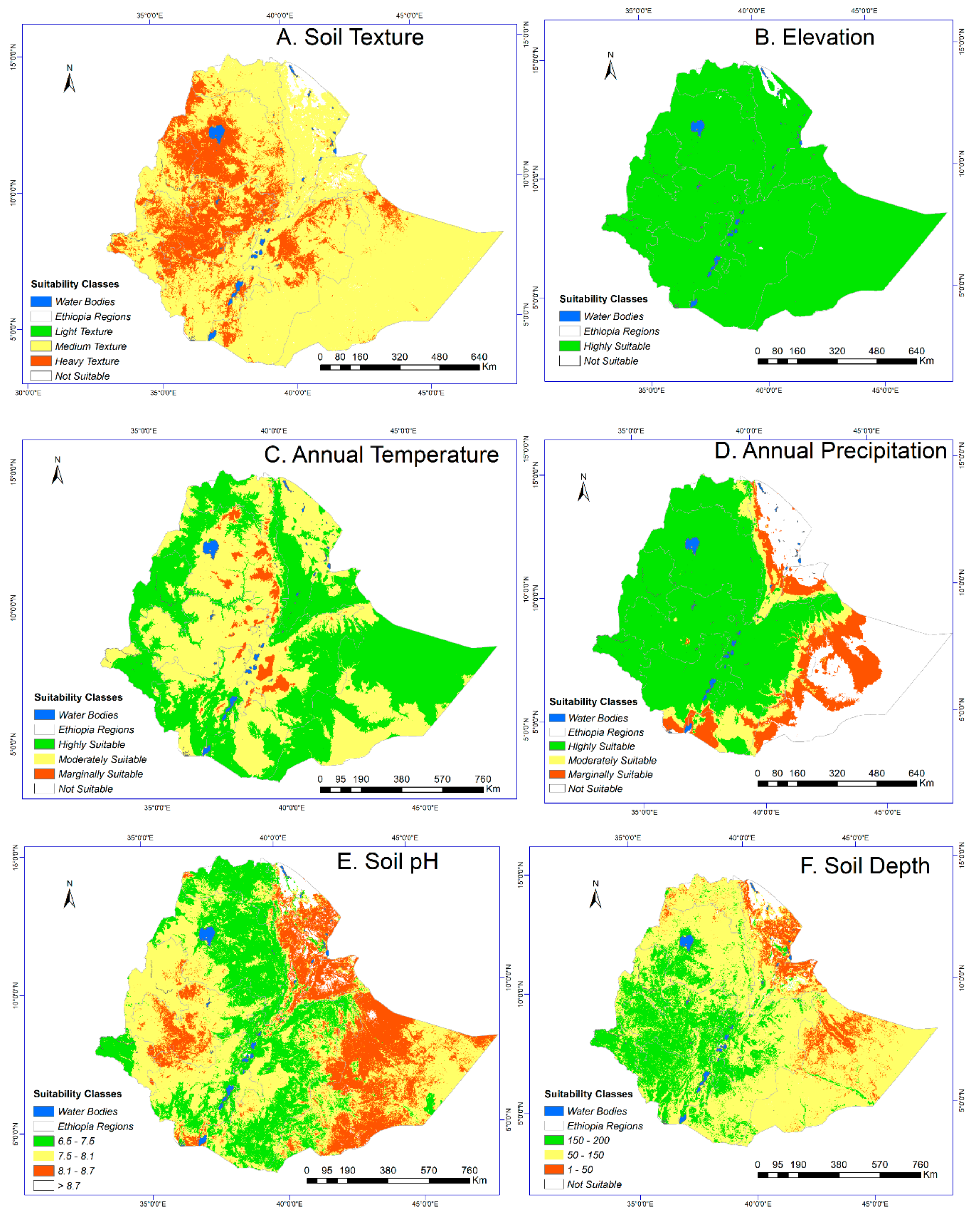
2.2. Land Suitability Analysis and Classification

The land suitability analyses are conducted using environmental conditions that determine alfalfa growth, which were obtained from the FAO Ecocrop Database [35]. The Ecocrop database provide information on key climate and soil requirements that inform optimal and overall growth for various plant species.
For the suitability evaluation, a geospatial analysis was conducted on the absolute and optimal ranges of maximum and minimum temperature, precipitation, topography (elevation), and soil characteristics (texture, depth, and pH). The factors affecting suitability of a land for fodder production were mapped with ArcGIS 10.2.2.
A suitability level was assigned for each parameter based on the FAO land suitability classification system [18]. The suitability levels used were highly suitable (S1), moderately suitable (S2), marginally suitable (S3), and not suitable (N). The definitions of the FAO framework for these land suitability classifications are summarized in Table 2.

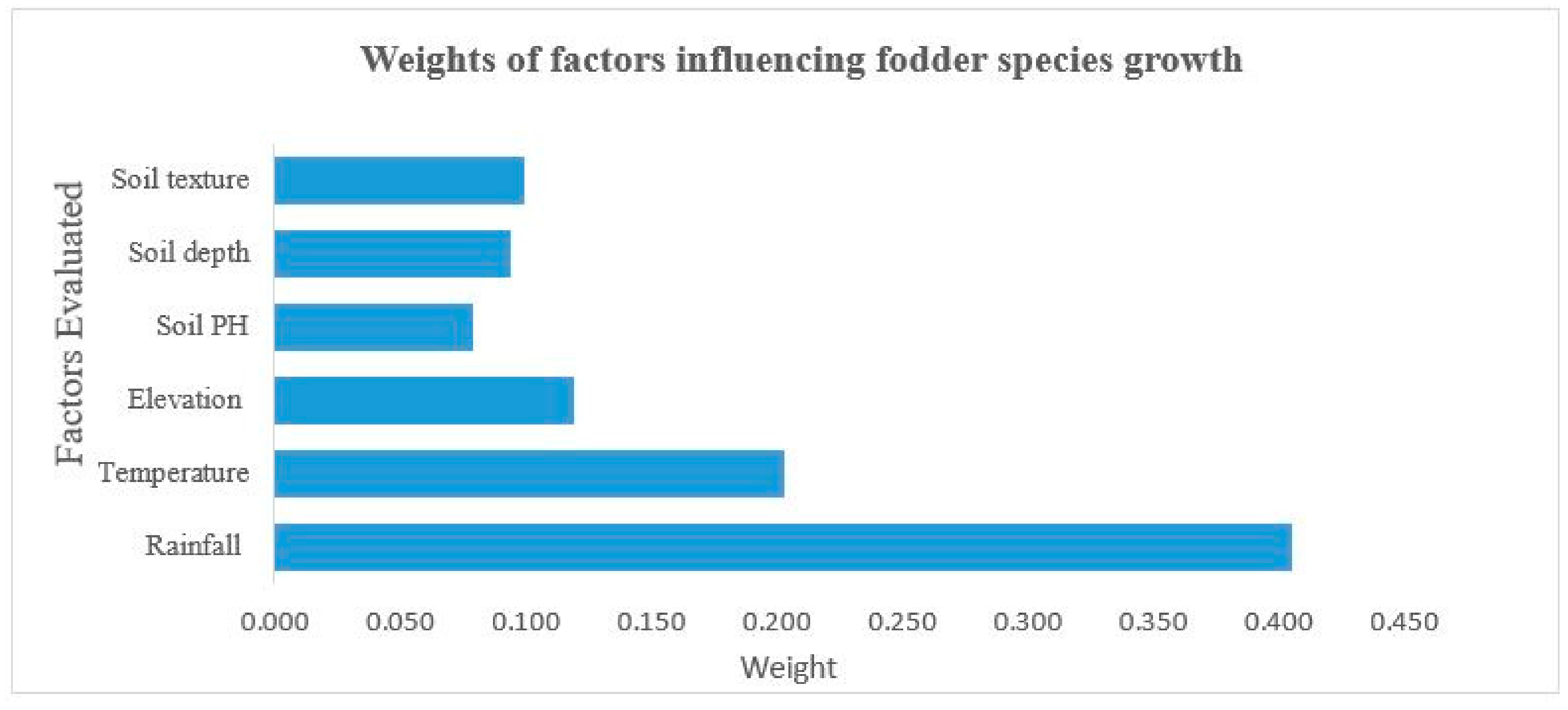
2.3. Weighting of Factors

The analytical hierarchy process (AHP) was used to determine the weights of the factors. In AHP, factors were compared one to one to prepare a comparison matrix (Table 4). Each factor within the matrix was compared to the others using the importance scale from 1 to 9 as described in Table 3 in which 1 refers equal importance and 9 refers extreme importance [38]. Expert opinion was used to assign importance rankings to each criterion. Experts involved in the importance raking were from the field of climate, agronomy, and soils. Moreover, relevant information and parameters obtained from the literature review were also used to assign the importance rankings for the paired criterion [22,39]. The final rankings integrate expert opinion and literature recommendations (Table 5).
The scale rating (i.e., the intensity of values/importance in Table 4) indicates the importance of each criterion when compared in a pairwise fashion. A value of 1 indicates that the factor is of equal importance to another factor in the pairwise comparison, while a value of 9 is given for those factors having an extreme importance over another factor in the pairwise comparison [41]. In cases where the factor is important, the corresponding matrix position automatically gets a reciprocal value. All elements in the diagonal of the pairwise comparison matrix have values of one since the comparison is between the same criterions. For example, from the pairwise comparison matrix based on the expert judgments for the rating of temperature relative to elevation, an importance rating of 2/7 was determined. Therefore, the rating of elevation to temperature would be the reciprocal value of 4 1/2 which indicates that the factor is less important [38]. The assigned preference values from the expert and literature reviews were integrated to determine the ranking of the important factors through arithmetic mean of the expert and literature review importance rankings [42]. The weighting factor is an important step to consider and requires adequate knowledge and review of the parameters when assigning criteria. This was the main reason for consulting experts in the field. The experts were asked to compare factors used in the present study (i.e., rainfall, temperature, elevation, soil depth, soil texture and soil pH) and to assign weights based on factor’s importance for alfalfa growth.
The experts applied the AHP method to calculate the important weighting factors by comparing relevant criteria against each other in a pairwise comparison matrix to measure and express the relative importance of each factor and between the factors. The expert opinion was collected through a survey and a web-based AHP solution tool (https://bpmsg.com/academic/ahp.php) that was used to calculate the relative ranking. According to a consistency ratio (CR) evaluation Saaty [40], the results from individual experts indicated that the AHP method was applied correctly and the judgements were in acceptable range.
The eigenvalue and eigenvectors of the pairwise comparison matrix was calculated based on Saaty [43] to estimate the relative weights for each factor used. The matrix was normalized by the total value. We used a consistency ratio (CR) to check if the original preference ratings were consistent [43]. Consistency index (CI) reflects the consistency of one’s judgment, as depicted below:
CR = CI/RI
where CR is the consistency ratio, CI is the consistency index and RI is the random index given by Saaty [40], and n: the numbers of criteria in each pairwise comparison matrix used [40]. The consistency index (CI) is estimated using the following Equation:
CI = λ max n n 1
Random Index (RI) is the CI of a randomly generated pairwise comparison matrix, λmax is the average eigenvalue or weights of the matrix, and n is the order of the matrix. Saaty [40] stated that a CR of 0.1 or less is considered as an acceptable value, and any greater value at any level indicates that judgments require revisions.
When several individuals provide judgments, Forman and Peniwati [42] suggested that aggregating individual judgment (AIJ) or aggregating individual priority (AIP) is essential to make a decision. Moreover, the process of selecting the method depends on the information gathered from participants whether the participants are assumed to act together as a group or as separate individuals. In the present study, the participants were responding individually and there was no discussion among themselves. Therefore, an arithmetic mean (i.e., representing an average interval) was used [42]. In addition, the arithmetic mean had a lower CR value which falls into the acceptable range according to Saaty [43].
Integration with GIS was performed once the rankings, standardization of the thematic layers and calculation of their weights werecompleted. Weighted sum overlay function in ArcGIS 10.2.2 was used to produce the final alfalfa fodder suitability maps for both current and climate change scenarios.

2.4. Climate Risk Analysis

The climate risk analysis was conducted to compare the changes in suitability classifications (current vs. future) using predicated climate data of temperature and rainfall from the three GCM models. The temperature datasets were processed to calculate annual averages while precipitation data were evaluated for annual sums for each considered climate model data. The same classification procedure applied to the current climate was also used for the MCE analysis of the climate change scenarios to produce land suitability maps for the projected climate change. The suitability maps for the future climate were compared with current climate land suitability maps to evaluate the changes in suitability classes due to climate change.

2.5. Rainfall Deficit as a Surrogate for Irrigation Requirement

The difference between the actual and the optimal amount of rainfall needed for alfalfa production was used as a surrogate for the irrigation amount that would be required for optimal growth. The rainfall deficit within the boundary of each suitability class is produced using the final suitability map. A “rainfall requirement” raster was created using the midpoint between the maximum and minimum optimal rainfall listed in the EcoCrop database. For example, the rainfall requirement for alfalfa was computed as the midpoint between minimum optimal value (1500 mm) and the maximum optimal value (2500 mm) resulting in 2000 mm as the “rainfall requirement” for optimal growth. The optimal rainfall requirement raster was subtracted from the current and future rainfall amounts for each pixel within the boundaries of land classified suitability. This difference was used to map irrigation amounts that would be needed at a given location to ensure optimal growth of alfalfa. The water deficit ranges were classified into five equal intervals, and the area that falls under a 20% water deficit were presented.

3. Results

3.1. Weighting of Factors

The pairwise comparison analysis using input from expert opinion indicated that rainfall was the most important factor determining the land suitability for fodder production followed by temperature and altitude (Figure 3, Table 5). The CR for the pairwise comparison matrix for fodder suitability was found to be 0.054 (i.e., CR < 0.1), signifying that the judgment applied had a realistic level of consistency [22,26,27,44].
Figure 4 presents the spatial pattern of the land suitability analysis of individual factors (i.e., classifications of suitability based on rainfall, temperature, elevation, soil pH, and soil depth and soil texture individually). The individual factor suitability classification shows that the majority of the soil texture, elevation, and precipitation conditions in Ethiopia are highly suitable for the growth of alfalfa. However, areas in the western part of the country were moderately suitable for alfalfa due to soil texture and soil pH, whereas areas in the eastern part of the country were marginally suitable due to soil pH and soil depth.

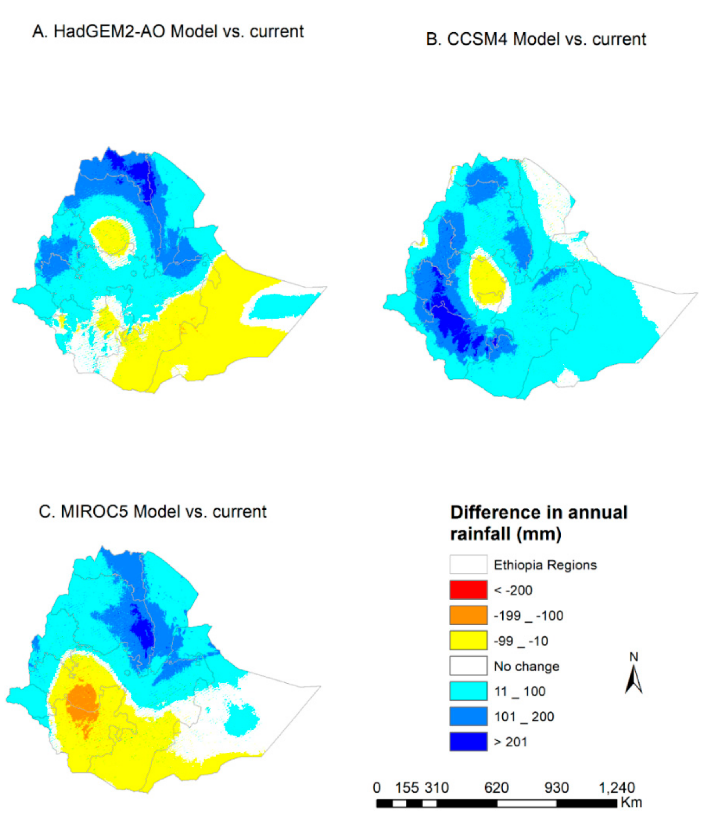
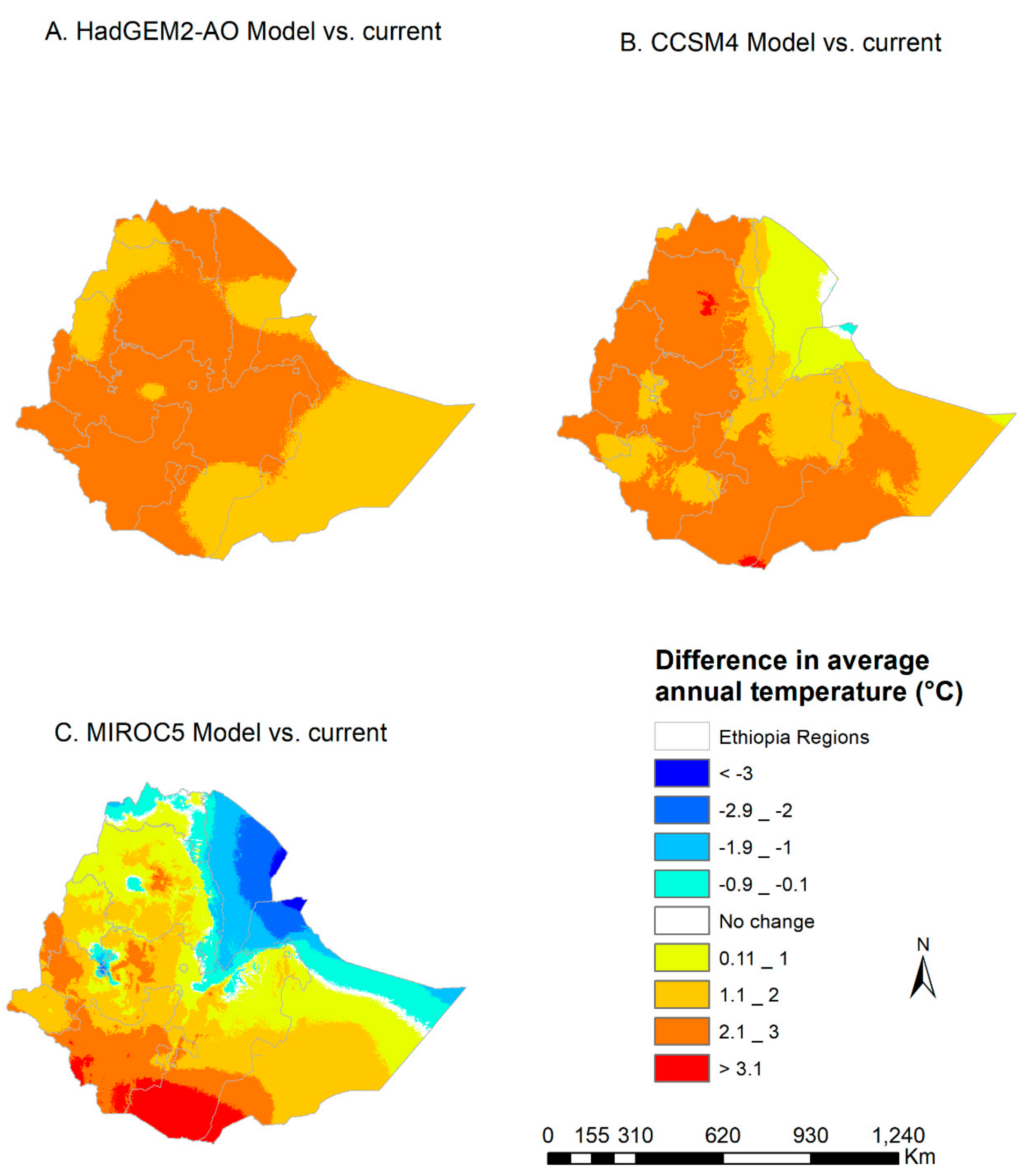
3.2. Projected Climate Change

Given that precipitation and temperature are the dominant weighting factors in classifying suitable areas, changes in rainfall and temperature were assessed by comparing future (2041–2060) and current climate. The results of rainfall and temperature differences between the current and future climate for all regions of Ethiopia are discussed below.
The HadGEM2-AO model projected the highest annual increase in annual rainfall (>200 mm) in the northern part of the country, whereas the maximum decline in annual rainfall (<−100 mm) is expected to occur in the central northern highlands, and in the southeastern regions of the country (Figure 5A).
On the other hand, the CCSM4 model projected the highest increases in annual rainfall (>200 mm) in the southwest part of Ethiopia, whereas the maximum decline in rainfall (<−100 mm) is projected in the central highlands (Figure 5B).
Similar to the HadGEM2-AO model, MIROC5 projected the highest increase in annual rainfall (>200 mm) in the northeastern part of the country. A maximum decline in precipitation (<−200 mm) is expected to occur in the central and southern part of the country (Figure 5C). The differences in rainfall between the baseline period and future time horizon for the different climate models (Figure 5A–C) were caused by the different assumptions of climate models on climate change driving factors and their key relationship.
The temperature projection for the 2050s (2041–2060) under the RCP4.5 scenario generally shows an increase in temperature in most parts of Ethiopia (Figure 6). The HadGEM2-AO model projected an increase in temperature by about 1.1 to 3 °C across much of Ethiopia (Figure 6A). Likewise, the CCSM4 model projected an increase in temperature over most parts of Ethiopia (Figure 6B), except a cooling by −0.1 °C in few pocket areas of northeastern Ethiopia. On the other hand, contrary to the two climate models, the MIROC5 model projected more areas of cooling, especially in the eastern lowlands, and central part of the country (which extends from north to south) by 0.9 to 3 °C. However, the MIROC5 model also expected an increase in temperature by more than 3 °C in the southern part of Ethiopia (Figure 6C).

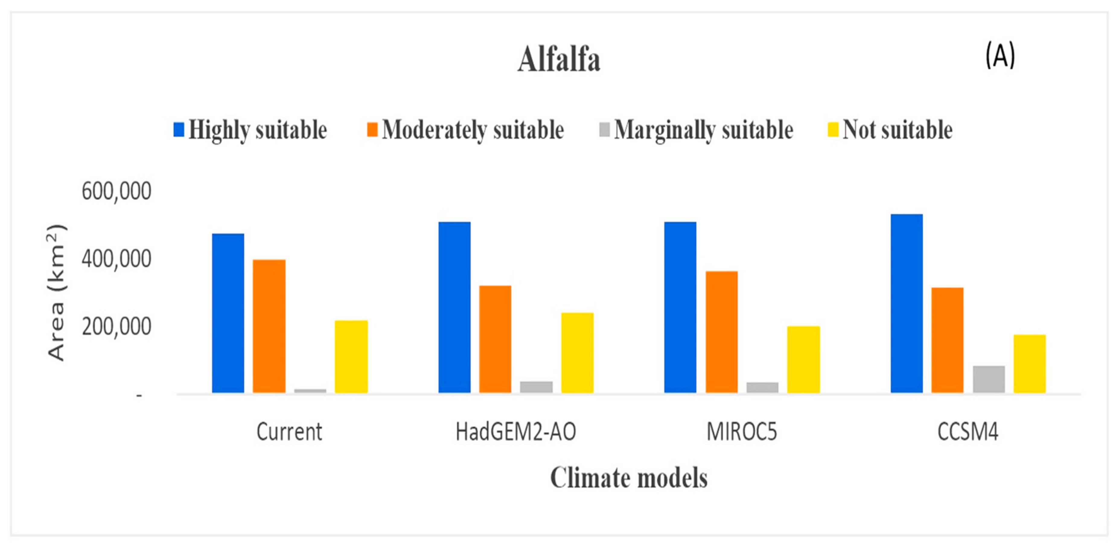
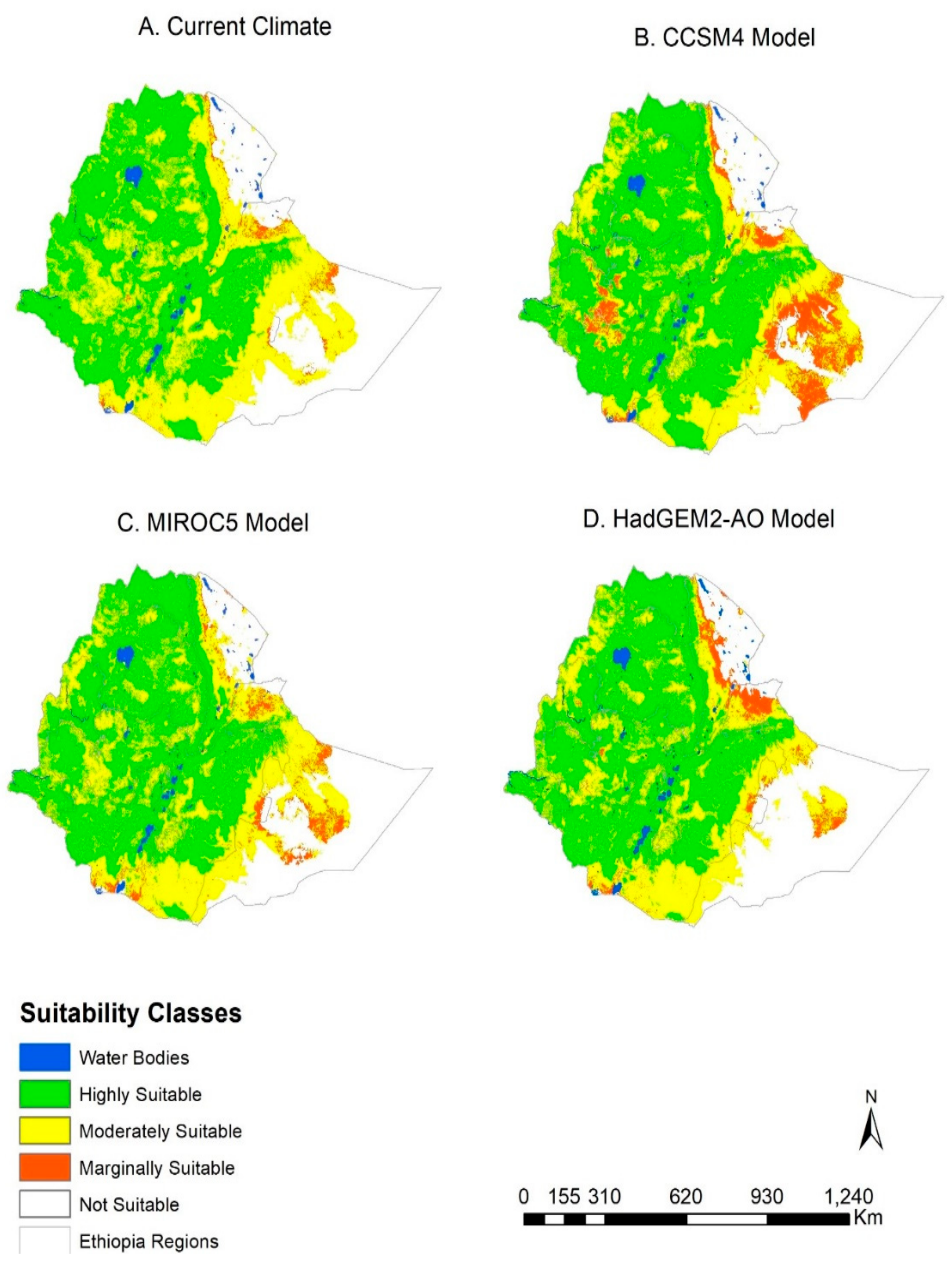
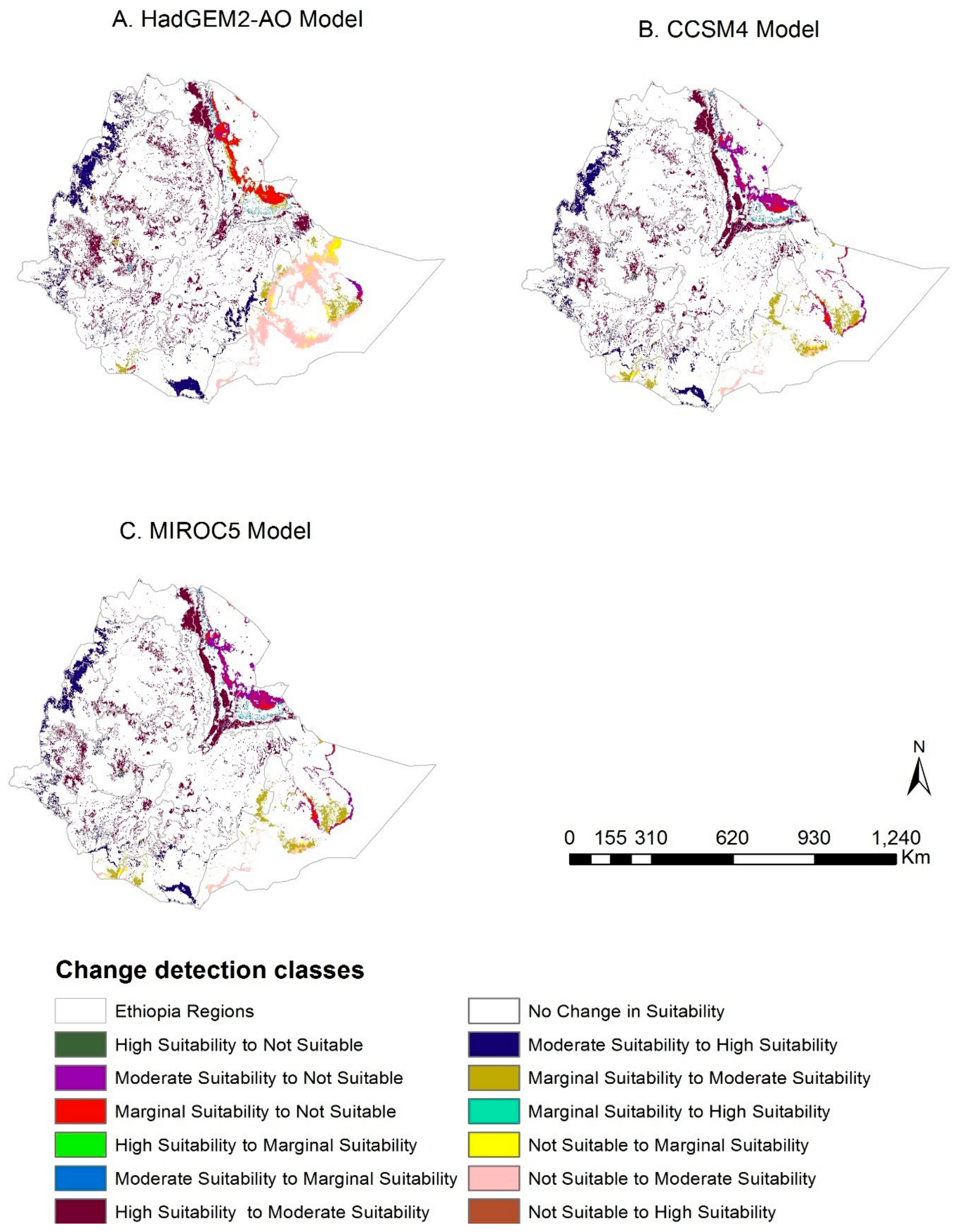
3.3. Potential Suitable Land for Current and Future Climate

The results of the MCE land suitability analysis under current and future climate are summarized in Figure 5. The projections from all the three climate models indicate that moderate and marginal suitable area for alfalfa are likely to increase in most parts of the country in the 2050s (2041–2060). A slight increase in highly suitable areas for alfalfa is also expected most parts of the country as compared to the base period (Figure 7). For example, the total area that was highly suitable for alfalfa under the current climate scenarios covered 472,153 km2 (43% of the total land in Ethiopia), whereas 397,133 km2 (36%) for moderately suitable and 16,165 km2 for marginally suitable land. Under the future climate conditions, the highly suitable area for alfalfa was 531,769 km2 (48%), 508,615 km2 (46%) and 507,218 km2 (46%) under CCSM4, HadGEM2-AO, MIROC5 climate models, respectively.
CCSM4 and HadGEM2-AO models predicted an increase in suitability, and as a result more land is expected to shift from not suitable to marginally suitable in the eastern part of Ethiopia (Figure 8). The highly suitable areas for alfalfa are predominantly located in the western and central highlands of Ethiopia where the annual rainfall amount is high. Rainfall was the primary factor driving the changes. According to Ecocrop [35], alfalfa requires more than 350 mm of annual rainfall to grow while 1500 mm annual rainfall is required for optimal growth. Based on the climate scenario analysis, alfalfa is predicted to get convenient environment due to climate change particularly in the highly suitable areas where rainfall is sufficient year-round.
The impacts of climate change on land suitability classification for alfalfa is analyzed by comparing the land suitability maps under current and future climate scenarios (Figure 9). A change detection for suitability classes showed a shift from moderate to high and marginal to highly suitable, respectively, under the CCSM4 model (Figure 9B). Similarly, an increase in suitability was predicted shifting from not suitable to moderately suitable under the HadGEM2-AO model (Figure 9A) while moderate to highly suitable shift was also predicted under MIROC5 (Figure 9C).

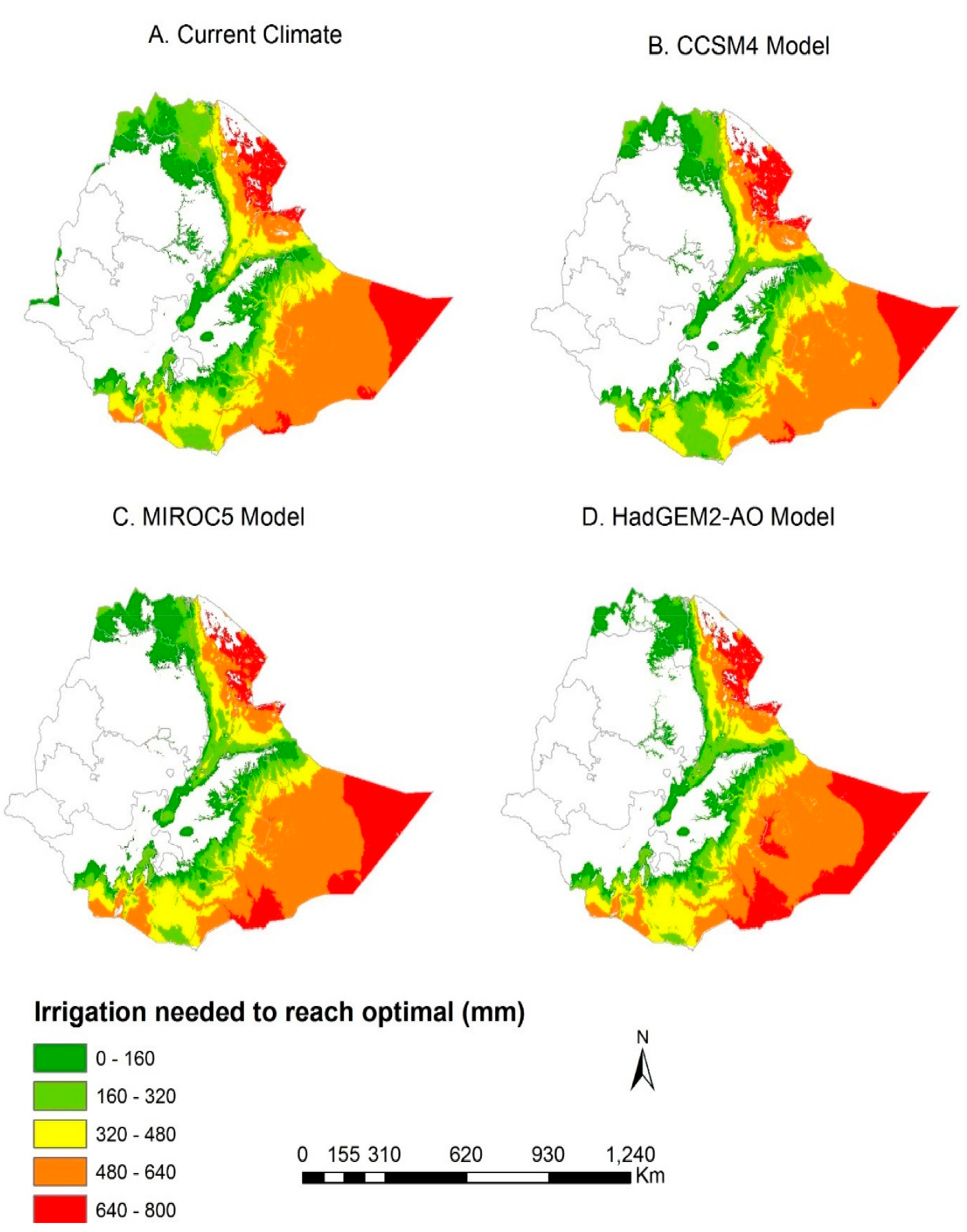
3.4. Precipitation Requirements to Meet Optimal Growth

Taking rainfall as a major determinate for fodder production, the impact of climate change on future rainfall availability was evaluated. The water deficit ranges were classified into five equal intervals (Figure 10), and the area that falls under a 20% water deficit for the respective climate models is also presented in Table 6. North central parts of the country can optimally produce alfalfa only using rainfall while the eastern part of the country may require an irrigation amount of up to 800 mm of water to produce optimal production of alfalfa (Figure 10). Under current and future climate scenarios, the 20% rainfall deficit areas vary across all the climate models (Table 6).

4. Discussion

There is a consensus within the scientific community that climate change may impact the livestock production system by reducing feed quality and quantity [11,12,45,46,47,48,49]. Despite this general consensus that grazing lands may deteriorate due to climate change [7,12,13,46,50], limited studies exist that examine the effects of climate change on fodder production or land suitability for fodder production, particularly in Ethiopia. This study, therefore, studied land suitability for alfalfa fodder production in Ethiopia under current and future climate change scenarios using three GCMs (CSMSM4, HadGEM2-AO, and MIROC5) models. The study also examined the shift in land suitability and supplemental irrigation needs for alfalfa production due to climate change.
The land suitability analysis showed that rainfall is the most influencing factor for alfalfa production in Ethiopia. This suggests the critical impact of climate change on the future fodder production and thereby the livelihoods of pastoralists and smallholder farmers (Figure 3 and Table 5). A significant part of the Ethiopian land (i.e., 472,153 km2, 43% of the total land) was identified as highly suitable for alfalfa production under the current climate conditions. Furthermore, the analysis for future climate conditions showed that the highly suitable land for alfalfa production may increase due to convenient climate for the fodder species. Likewise, more land will convert from not suitable to marginally suitable as a result of change in climate (Figure 7 and Figure 8). Since rainfall was the most influencing factor, the level of land suitability was improving in the future more likely due to an increase in rainfall in most parts of Ethiopia. Areas located in western, central and eastern parts of Ethiopia that receive annual rainfall of above 350 mm are identified as highly suitable areas for alfalfa production under the selected climate scenario. Areas that receive small amounts of rainfall (<350 mm) in the current and future climate change conditions such as the arid and semi-arid areas of northeast and southeast of Ethiopia were found to be unsuitable for alfalfa production. Moreover, most of the areas that showed a rainfall deficit in all the three climate models are located in the lowland or dryland areas of the country. Similarly, earlier studies [51] reported that the suitability for fodder production is lower in areas experiencing higher temperatures and lower rainfall. Other studies [45,48] highlighted that the drylands of Ethiopia experience frequent drought due to climate variability, which often hampers crop productivity in these areas due to the water shortage and temperature stress—Geerts and Raes [52].
Evaluation of the suitability study under plausible climate change scenarios indicated that there will be shifts in suitability classes as a result of climate change (Figure 9). For the years 2041–2060, all the three models (CCSM4, HadGEM2-AO and MIROC5) predicted an increase in rainfall and temperature, which created a suitable environment for alfalfa cultivation. The land suitability analysis using the climate change scenarios showed better land suitability conditions compared to the current suitability state. For example, a significant shift in suitability was observed from marginally suitable and not suitable conditions, to moderately suitable and marginally suitable, respectively (Figure 7 and Figure 8). Given alfalfa’s drought resistant nature [26,53], the expected increase in suitable areas for alfalfa due to a plausible climate change scenario suggests that the fodder crop is a valuable future feed for livestock to build resilience in the pastoralists and smallholder farmers in Ethiopia.
Since climate and agriculture are highly interlinked, climate change may threaten the fragile agricultural system in Africa [54]. There are some studies [55,56,57] which already indicate the climate variability and change may decrease agriculture productivity in large parts of Sub-Saharan Africa. And Ethiopia is one of the African countries where the economy is highly vulnerable to climate variability and climate change [58]. Conway and Schipper [59] corroborated that Ethiopia is one of the Sub-Saharan African countries where agricultural activity and food security are highly sensitive to climate-related risks. As such, food production and livelihoods of the Ethiopian population are directly impacted by the recurrent droughts and other climate related extremes. However, impacts of climate change, are likely to be variable in different regions and crops. Some regions and crops may benefit from a changed climate while others may be adversely affected [60]. Our findings showed that the impact of climate change on alfalfa crop production may be positive due to better temperature and rainfall situations for crop optimal growth. In fact, if appropriate crop management interventions will be employed, such as better nutrient management, there is a possibility to expand the production of these feedstock into areas which are not currently suitable to this crop. Therefore, there is a need to consider the regional impacts of climate change, as the variability of the climate within the season may lead to a different conclusion. Hence, our results should be interpreted with such considerations.

5. Conclusions

This study is one of the first to assess land suitability regions for fodder production at a national level using spatial analysis tools such as MCE and AHP over Ethiopia. The analysis used climate, soil, and elevation information to map land suitability for fodder production under both current and future climatic conditions.
The pairwise comparison of factors, based on expert rankings indicated that rainfall, temperature and elevation are the most important factors in determining the alfalfa land suitability. Additionally, out of the three, rainfall is ranked as the most important factor in determining the suitability for alfalfa fodder species. The land suitability analysis based on the three climate models (CSMSM4, HadGEM2-AO, and MIROC5) under RCP4.5 scenario showed that the land suitability for alfalfa is expected to increase in the 2050s. For example, currently unsuitable land may shift to suitable categories due to climate change providing an opportunity to grow alfalfa in areas that do not support such crop growth under the current environmental conditions. The expansion of highly suitable areas are generally observed in the highlands of Ethiopia where the climate models projected an increase in temperature and precipitation. On the other hand, areas in the lowland or dryland regions of the country may experience a rainfall deficit due to climate change. In such areas optimal production of alfalfa may not be achieved unless the rainfall deficit will be supplemented by irrigation.
The findings of this study provide evidence to development planners, livestock producers and policy makers for various current and future climate change scenario-based land suitability, climate change risk and supplemental irrigation need analyses for crop and feedstock productivity improvement in Ethiopia. Furthermore, the results provide guidance where to grow alfalfa considering ecological and climate variability, as well as informing a need for supplemental irrigation systems to grow this feed stock optimally and thereby support the livestock sector and resource-poor vulnerable communities that depend on it.
It has to be noted that this study uses global models that are relatively coarser to accurately represent regional and local surface heterogeneity such as complex topography of Ethiopia. The use of annual rainfall as an evaluation criterion also contributes to this uncertainty. Nevertheless, the inclusion of soil depth and elevation should address part of the uncertainty in that deeper soils provide more storage for moisture, and flatter elevation enables a lagged flow facilitating the filling of the soil reservoir. Future study with higher resolution regional climate models (such as from CORDEX data) might be useful for kind of regional application. Furthermore, this study uses a single emission scenario (RCP 4.5), further study might benefit from incorporating multiple representative concentration pathways that account for uncertainties in future emission scenarios.

Author Contributions

The contribution of the authors of the paper is as follows: S.A.: Developed the concept, Methodology, Performed the analysis, Investigation, Data curation, Writing—original draft, Writing—review & editing; E.K.A.: Investigation and supervised the finding, Data curation, Writing—review & editing; Y.T.D.: Investigation and supervised the finding, Data curation, Writing—review & editing; T.D.: Investigation, Data curation, Writing—review & editing; Y.Y.: Investigation, Data curation, Writing—review & editing; E.G.: Investigation and supervised the finding, Data curation, Writing—review & editing, funding acquisition; E.A.: Investigation, Data curation, Writing—review & editing; D.S.: Investigation, Data curation, Writing—review & editing; A.W.W.: Investigation, Data curation, Writing—review & editing. All authors have read and agreed to the published version of the manuscript.

Funding

This research received no external funding.

Acknowledgments

This publication was made possible through support provided by Feed the Future through the U.S. Agency for International Development, under the terms of Contract No.AID-OAA-A-13-0005, and Texas A&M University AgriLife Research. The opinions expressed herein are those of the authors and do not necessarily reflect the views of the U.S. Agency for International Development. The editor and the anonymous reviewers gratefully acknowledged for their valuable comments on our manuscript.

Conflicts of Interest

The authors declare no conflict of interest.

References

  1. CSA. Agricultural Sample Survey, 2016/17 (2009 E.C), Volume II: Report on Livestock and Livestock Characteristics (Private Peasant Holdings). Statistical Bulletin 585 ed. 2017, Addis Ababa, Ethiopia Central Statistical Agency (CSA), Federal Democratic Republic of Ethiopia. Available online: https://www.worldcat.org/title/agricultural-sample-survey-volume-ii-report-on-livestock-and-livestock-characteristics-private-peasant-holdings/oclc/58954342 (accessed on 6 July 2020).
  2. Leta, S.; Mesele, F. Spatial analysis of cattle and shoat population in Ethiopia: Growth trend, distribution and market access. SpringerPlus 2014, 3, 310. [Google Scholar] [CrossRef] [PubMed] [Green Version]
  3. Lemenih, M.; Abebe, T.; Olsson, M. Gum and resin resources from some Acacia, Boswellia and Commiphora species and their economic contributions in Liban, south-east Ethiopia. J. Arid. Environ. 2003, 55, 465–482. [Google Scholar] [CrossRef]
  4. Ngigi, S.N. What is the limit of up-scaling rainwater harvesting in a river basin? Phys. Chem. Earth 2003, 28, 943–956. [Google Scholar] [CrossRef]
  5. Coppock, D.L. The Borana Plateau of Southern Ethiopia: Synthesis of Pastoral Research. Dev. Chang. 1980, 91, 393. [Google Scholar]
  6. Thornton, P.; Van De Steeg, J.; Notenbaert, A.; Herrero, M. The impacts of climate change on livestock and livestock systems in developing countries: A review of what we know and what we need to know. Agric. Syst. 2009, 101, 113–127. [Google Scholar] [CrossRef]
  7. Thornton, P.K.; Gerber, P.J. Climate change and the growth of the livestock sector in developing countries. Mitig. Adapt. Strat. Glob. Chang. 2010, 15, 169–184. [Google Scholar] [CrossRef]
  8. Yayneshet, T.; Eik, L.; Moe, S.R. Feeding Acacia etbaica and Dichrostachys cinerea fruits to smallholder goats in northern Ethiopia improves their performance during the dry season. Livest. Sci. 2008, 119, 31–41. [Google Scholar] [CrossRef]
  9. Berhe, M.; Hoag, D.; Tesfay, G.; Tadesse, T.; Oniki, S.; Kagatsume, M.; Keske, C.M.H. The effects of adaptation to climate change on income of households in rural Ethiopia. Pastor. Res. Policy Pract. 2017, 7, 12. [Google Scholar] [CrossRef]
  10. Rojas-Downing, M.M.; Nejadhashemi, A.P.; Harrigan, T.; Woznicki, S.A. Climate change and livestock: Impacts, adaptation, and mitigation. Clim. Risk Manag. 2017, 16, 145–163. [Google Scholar] [CrossRef]
  11. Megersa, B.; Markemann, A.; Angassa, A.; Ogutu, J.O.; Piepho, H.-P.; Zárate, A.V. Impacts of climate change and variability on cattle production in southern Ethiopia: Perceptions and empirical evidence. Agric. Syst. 2014, 130, 23–34. [Google Scholar] [CrossRef]
  12. Kassahun, A. Pastoralism and the Need for Future Intervention in Pastoral Areas of Ethiopia; Annual Review on National Dry Land Agricultural Research Systems: Addis Ababa, Ethiopia, 2003. [Google Scholar]
  13. Desta, S.; Coppock, D.L. Cattle Population Dynamics in the Southern Ethiopian Rangelands, 1980-97. J. Range Manag. 2002, 55, 439. [Google Scholar] [CrossRef]
  14. Gebregziabher, G.; Haileslassie, A. Assessments of Key Small-Scale Irrigation Technologies, Agricultural Water Management Options and Integrated Irrigated Fodder in Ethiopia; USAID: Washington, DC, USA, 2014. [Google Scholar]
  15. Derseh, M.B.; Duncan, A.J.; Mekonnen, K.; Adie, A.; Khan, N.A.; Thorne, P. The role of irrigated fodder production to supplement the diet of fattening sheep by smallholders in southern Ethiopia. Trop. Subtrop. Agroecosystems 2016, 19, 263–275. [Google Scholar]
  16. FAO. A Framework for Land Evaluation. Soils Bulletin 32. Rome, Italy. 1976. Available online: http://www.fao.org/3/x5310e/x5310e00.htm (accessed on 6 July 2020).
  17. Ahamed, T.N.; Rao, K.G.; Murthy, J. GIS-based fuzzy membership model for crop-land suitability analysis. Agric. Syst. 2000, 63, 75–95. [Google Scholar] [CrossRef]
  18. Wang, F.; Hall, G.B.; Subaryono, G. Fuzzy information representation and processing in conventional GIS software: Database design and application. Int. J. Geogr. Inf. Syst. 1990, 4, 261–283. [Google Scholar] [CrossRef]
  19. Al-Mashreki, M.H.; Akhir, J.B.M.; Kadderi, D.M.; Lihan, T.; Haider, A. Land suitability evaluation for sorghum crop in the Ibb Governorate, Republic of Yemen using remote sensing and GIS techniques. Aust. J. Basic Appl. Sci. 2011, 5, 359–368. [Google Scholar]
  20. Kihoro, J.; Bosco, N.J.; Murage, H. Suitability analysis for rice growing sites using a multicriteria evaluation and GIS approach in great Mwea region, Kenya. SpringerPlus 2013, 2, 265. [Google Scholar] [CrossRef] [PubMed] [Green Version]
  21. Kazemi, H.; Sadeghi, S.; Akıncı, H.; Akinci, H.; Akinci, H. Developing a land evaluation model for faba bean cultivation using geographic information system and multi-criteria analysis (A case study: Gonbad-Kavous region, Iran). Ecol. Indic. 2016, 63, 37–47. [Google Scholar] [CrossRef]
  22. Elaalem, M.; Comber, A.; Fisher, P. A Comparison of Fuzzy AHP and Ideal Point Methods for Evaluating Land Suitability. Trans. GIS 2011, 15, 329–346. [Google Scholar] [CrossRef]
  23. Janssen, R.; Rietveld, P. Multicriteria analysis and geographical information systems: An application to agricultural land use in the Netherlands. In Geographical Information Systems for Urban and Regional Planning; Springer: Dordrecht, The Netherlands, 1990; pp. 129–139. [Google Scholar]
  24. Deng, F.; Li, X.; Wang, H.; Zhang, M.; Li, R.; Li, X. GIS-based assessment of land suitability for alfalfa cultivation: A case study in the dry continental steppes of northern China. Span. J. Agric. Res. 2014, 12, 364–375. [Google Scholar] [CrossRef] [Green Version]
  25. Worqlul, A.W.; Jeong, J.; Dile, Y.T.; Osorio, J.; Schmitter, P.; Gerik, T.; Srinivasan, R.; Clark, N. Assessing potential land suitable for surface irrigation using groundwater in Ethiopia. Appl. Geogr. 2017, 85, 1–13. [Google Scholar] [CrossRef]
  26. Gebrehiwot, S.G. Forests, water and food security in the northwestern highlands of Ethiopia: Knowledge synthesis. Environ. Sci. Policy 2015, 48, 128–136. [Google Scholar] [CrossRef]
  27. Hijmans, R.J.; Cameron, S.E.; Parra, J.L.; Jones, P.G.; Jarvis, A. Very high resolution interpolated climate surfaces for global land areas. Int. J. Clim. 2005, 25, 1965–1978. [Google Scholar] [CrossRef]
  28. Hengl, T.; Heuvelink, G.B.M.; Kempen, B.; Leenaars, J.G.B.; Walsh, M.G.; Shepherd, K.D.; Sila, A.; Macmillan, R.A.; De Jesus, J.M.; Tamene, L.; et al. Mapping Soil Properties of Africa at 250 m Resolution: Random Forests Significantly Improve Current Predictions. PLoS ONE 2015, 10, e0125814. [Google Scholar] [CrossRef] [PubMed]
  29. Gent, P.R.; Danabasoglu, G.; Donner, L.J.; Holland, M.M.; Hunke, E.C.; Jayne, S.R.; Lawrence, D.M.; Neale, R.B.; Rasch, P.J.; Vertenstein, M.; et al. The Community Climate System Model Version 4. J. Clim. 2011, 24, 4973–4991. [Google Scholar] [CrossRef]
  30. Collins, W.; Bellouin, N.; Doutriaux-Boucher, M.; Gedney, N.; Halloran, P.; Hinton, T.; Hughes, J.; Jones, C.D.; Joshi, M.; Liddicoat, S.; et al. Development and evaluation of an Earth-System model-HadGEM2. Geosci. Model Dev. Discuss. 2011, 4, 1051. [Google Scholar] [CrossRef] [Green Version]
  31. Watanabe, M.; Suzuki, T.; O’Ishi, R.; Komuro, Y.; Watanabe, S.; Emori, S.; Takemura, T.; Chikira, M.; Ogura, T.; Sekiguchi, M.; et al. Improved Climate Simulation by MIROC5: Mean States, Variability, and Climate Sensitivity. J. Clim. 2010, 23, 6312–6335. [Google Scholar] [CrossRef]
  32. Taylor, K.E.; Stouffer, R.J.; Meehl, G.A. An Overview of CMIP5 and the Experiment Design. Bull. Am. Meteorol. Soc. 2012, 93, 485–498. [Google Scholar] [CrossRef] [Green Version]
  33. Ecocrop, Ecocrop Database of the FAO. 2010. Available online: http://www.fao.org/land-water/land/land-governance/land-resources-planning-toolbox/category/details/en/c/1027491/ (accessed on 10 November 2019).
  34. Gorfu, D.; Ahmed, E. Crops and Agro-Ecological Zones of Ethiopia; Ethiopian Institute of Agricultural Research: Addis Ababa, Ethiopia, 2012. [Google Scholar]
  35. Vagen, T.; Shepherd, K.D.; Walsh, M.G.; Winowiecki, L.; Desta, L.T.; Tondoh, J.E. Afsis Technical Specifications: Soil Health Surveillance. Africa Soil Information Service (AfSIS); World Agroforestry Centre: Nairobi, Kenya, 2010. [Google Scholar]
  36. Mustafa, A.; Singh, M.; Sahoo, R.N.; Ahmed, N.; Khanna, M.; Sarangi, A.; Mishra, A.K. Land suitability analysis for different crops: A multi criteria decision making approach using remote sensing and GIS. Researcher 2011, 3, 61–84. [Google Scholar]
  37. Akıncı, H.; Özalp, A.Y.; Turgut, B. Agricultural land use suitability analysis using GIS and AHP technique. Comput. Electron. Agric. 2013, 97, 71–82. [Google Scholar] [CrossRef]
  38. Saaty, T.L. A scaling method for priorities in hierarchical structures. J. Math. Psychol. 1977, 15, 234–281. [Google Scholar] [CrossRef]
  39. Saaty, T.L. Decision making with the analytic hierarchy process. Int. J. Serv. Sci. 2008, 1, 83. [Google Scholar] [CrossRef] [Green Version]
  40. Forman, E.; Peniwati, K. Aggregating individual judgments and priorities with the analytic hierarchy process. Eur. J. Oper. Res. 1998, 108, 165–169. [Google Scholar] [CrossRef]
  41. Saaty, T.L. The Analytic Hierarchy Process; McGraw-Hill: New York, NY, USA, 1980. [Google Scholar]
  42. Koczkodaj, W.W.; Mikhailov, L.; Redlarski, G.; Soltys, M.; Szybowski, J.; Tamazian, G.; Wajch, E.; Yuen, K.K.F. Important Facts and Observations about Pairwise Comparisons (the special issue edition). Fundam. Inform. 2016, 144, 291–307. [Google Scholar] [CrossRef] [Green Version]
  43. Catley, A.; Admassu, B.; Bekele, G.; Abebe, D. Livestock mortality in pastoralist herds in Ethiopia and implications for drought response. Disasters 2014, 38, 500–516. [Google Scholar] [CrossRef] [Green Version]
  44. Giridhar, K.; Samireddypalle, A. Impact of climate change on forage availability for livestock. In Climate Change Impact on Livestock: Adaptation and Mitigation; Springer: New Delhi, India, 2015; pp. 97–112. [Google Scholar]
  45. Tuffa, S.; Treydte, A.C. Modeling Boran cattle populations under climate change and varying carrying capacity. Ecol. Model. 2017, 352, 113–127. [Google Scholar] [CrossRef]
  46. Wako, G.; Tadesse, M.; Angassa, A. Camel management as an adaptive strategy to climate change by pastoralists in southern Ethiopia. Ecol. Process. 2017, 6, 26. [Google Scholar] [CrossRef] [Green Version]
  47. Treydte, A.C.; Schmiedgen, A.; Berhane, G.; Tarekegn, K.D. Rangeland forage availability and management in times of drought—A case study of pastoralists in Afar, Ethiopia. J. Arid. Environ. 2017, 139, 67–75. [Google Scholar] [CrossRef]
  48. Rojas-Downing, M.M.; Nejadhashemi, A.P.; Abouali, M.; Daneshvar, F.; Al Masraf, S.A.D.; Herman, M.R.; Harrigan, T.; Zhang, Z. Pasture diversification to combat climate change impacts on grazing dairy production. Mitig. Adapt. Strat. Glob. Chang. 2017, 23, 405–431. [Google Scholar] [CrossRef]
  49. Hoffman, T.; Vogel, C. Climate Change Impacts on African Rangelands. Rangelands 2008, 30, 12–17. [Google Scholar] [CrossRef] [Green Version]
  50. Geerts, S.; Raes, D. Deficit irrigation as an on-farm strategy to maximize crop water productivity in dry areas. Agric. Water Manag. 2009, 96, 1275–1284. [Google Scholar] [CrossRef] [Green Version]
  51. Geleti, D.; Hailemariam, M.; Mengistu, A.; Tolera, A. Biomass yield potential and nutritive value of selected alfalfa (Medicago sativa L.) cultivars grown under tepid to cool sub-moist agro-ecology of Ethiopia. J. Agric. Res. Dev. 2014, 4, 7–14. [Google Scholar]
  52. Kajla, M.; Yadav, V.K.; Chhokar, R.S.; Sharma, R.K. Management practices to mitigate the impact of high temperature on wheat. J. Wheat Res. 2015, 7, 1–12. [Google Scholar]
  53. Melillo, J.M.; Richmond, T.; Yohe, G. Climate Change Impacts in the United States: Third National Climate Assessment; U.S. Global Change Research Program: Washington, DC, USA, 2014. [Google Scholar]
  54. Adhikari, U.; Nejadhashemi, A.P.; Woznicki, S.A. Climate change and eastern Africa: A review of impact on major crops. Food Energy Secur. 2015, 4, 110–132. [Google Scholar] [CrossRef]
  55. FAO. Climate-Smart Agriculture: Policies, Practises and Financing for Food Security, Adaptation and Mitigation; Paper Prepared for The Hague Conference on Agriculture, Food Security and Climate Change; FAO: Rome, Italy, 2010. [Google Scholar]
  56. World Bank. Ethiopia: Managing Water Resources to Maximize Sustainable Growth; A World Bank Water Resource Assistance Strategy for Ethiopia; World Bank: Washington, DC, USA, 2008. [Google Scholar]
  57. Conway, D.; Schipper, E.L.F. Adaptation to climate change in Africa: Challenges and opportunities identified from Ethiopia. Glob. Environ. Chang. 2011, 21, 227–237. [Google Scholar] [CrossRef]
  58. Yohannes, H. A review on relationship between climate change and agriculture. J. Earth Sci. Clim. Chang. 2015, 7, 335. [Google Scholar] [CrossRef]
  59. Jones, P.G.; Thornton, P.K. The potential impacts of climate change on maize production in Africa and Latin America in 2055. Glob. Environ. Chang. 2003, 13, 51–59. [Google Scholar] [CrossRef]
  60. Lobell, D.B.; Burke, M.B. Why are agricultural impacts of climate change so uncertain? The importance of temperature relative to precipitation. Environ. Res. Lett. 2008, 3, 034007. [Google Scholar] [CrossRef]
Figure 1. A map of the study area (Ethiopia and regions) depicting changes in elevation derived from a 30 m digital elevation model (DEM; Source http://www.worldclim.org/).
Atmosphere 11 01124 g001
Figure 2. General workflow of procedures for evaluating land areas suitable for alfalfa fodder production.
Atmosphere 11 01124 g002
Figure 3. Rank of factors subjected to an analytical hierarchy pairwise comparison procedure to evaluate land for fodder growth suitability.
Atmosphere 11 01124 g003
Figure 4. Land suitability maps for Alfalfa (Medicago sativa) based on soil texture (A), elevation (B), annual temperature (C), annual precipitation (D), soil pH (E) and soil depth (F). The factors were classified based on optimal and absolute growth parameters in Ecocrop (see Table 3).
Atmosphere 11 01124 g004
Figure 5. Differences in annual rainfall due to projected climate change between current climate (1970–2000) and three model scenarios ((A) Hadley global environment model 2 (HadGEM2-AO), (B) community climate system model version 4 (CCSM4), and (C) model for interdisciplinary research on climate (MIROC5)) representing the 4.5 representative concentration pathway (RCP) for the period of 2041–2060 in Ethiopia. The “no change” interval represents a rainfall difference of ±10 mm. This interval was considered as “no change” to accommodate different uncertainties in the climate data and approximations during the analysis.
Atmosphere 11 01124 g005
Figure 6. Differences in annual temperatures due to projected climate change between current climate (1970–2000) and three models ((A) HadGEM2-AO, (B) CCSM4, and (C) MIROC5) representing the 4.5 representative concentration pathway (RCP) for the period of 2041–2060 in Ethiopia.
Atmosphere 11 01124 g006
Figure 7. Results of the land area (km2) classified as highly, moderately, and marginally suitable using multi-criteria evaluation (MCE) and analytical hierarchy process (AHP) methods. The specie evaluated under current climate (1970–2000) and three global circulation models (HadGEM2-AO, MIROC5, and CCSM4,) representing the 4.5 representative concentration pathway (RCP) for the period of 2041–2060 in Ethiopia.
Atmosphere 11 01124 g007
Figure 8. Alfalfa suitability classes (i.e., highly, moderately and marginally) under (A) current climate (1970–2000) and three global circulation models ((B) CCSM4, (C) MIROC5, and (D) HadGEM2-AO) representing the 4.5 representative concentration pathway for the period of 2041–2060 in Ethiopia.
Atmosphere 11 01124 g008
Figure 9. Land area change in suitability classes for alfalfa between current climate (1970–2000) and three model scenarios ((A) HadGEM2-AO, (B) CCSM4, and (C) MIROC5) representing the 4.5 representative concentration pathway (RCP) for the period of 2041–2060.
Atmosphere 11 01124 g009
Figure 10. The spatial distribution of the rainfall deficit arears (mm) for alfalfa under current climate (1970–2000) and three global circulation models/scenarios (CCSM4, HadGEM2-AO and MIROC5) representing 4.5 representative concentration pathway (RCP) for the period of 2041–2060 in Ethiopia. The water deficit indicates the amount of irrigation needed to reach optimal crop water requirement.
Atmosphere 11 01124 g010
Table 1. Data used for the land suitability analysis.
CriteriaSourceResolution
Temperature—Average Annual Minimum and maximumWorldClim Dataset http://www.worldclim.org/tiles.php?Zone=27
Hijmans, R.J., S.E. Cameron, J.L. Parra, P.G. Jones and A. Jarvis, 2005. Very high-resolution interpolated climate surfaces for global land areas. International Journal of Climatology 25: 1965–1978.
30 arc seconds (~1-km2)
Precipitation—Annual precipitation (mm)WorldClim Datasethttp://www.worldclim.org/tiles.php?Zone=27
Hijmans, R.J., S.E. Cameron, J.L. Parra, P.G. Jones and A. Jarvis, 2005. Very high-resolution interpolated climate surfaces for global land areas. International Journal of Climatology 25: 1965–1978.
30 arc seconds (~1-km2)
ElevationUnited States Geological Survey (USGS) Shuttle Rader Topographic Mission (STRM)
https://glovis.usgs.gov/
30 arc seconds (~1-km2)
Soil pH
depth
texture
African Soil Information Services (AFSIS) http://africasoils.net/ [30]250 m grid resolution for 6 soil layers to 2.5 m deep
Table 2. The Food and Agriculture Organization (FAO) land suitability classification and descriptions [18] and numerical scale used to standardize the data into these suitability classes.
ClassesSuitabilityDescriptionNumerical
Scale
S1Highly suitableLand without significant limitations. Include the best 20–30% of suitable land as S1. This land is not perfect but is the best that can be obtained.1
S2Moderately suitableLand that is clearly suitable but has limitations that either reduce productivity or increase the inputs needed to sustain productivity compared with those needed on S1 land2
S3Marginally suitableLand with limitations so severe that benefits are reduced, and/or the inputs needed to sustain production are increased so that this cost is only marginally justified3
NNot suitableLand that cannot support the land use on a sustained basis, or land on which benefits do not justify necessary inputs4
Table 3. Land Suitability classification factors for alfalfa. Suitability classes were derived from climate, soil, and elevation requirements for optimal and absolute growth conditions for the specie and defined by ecocrop [35].
Suitability Classification Factors for Alfalfa
Suitability ClassesTemperature (°C)Rainfall (mm)Soil pHSoil TextureSoil Depth (cm)Elevation
(m)
Highly suitable21–27600–12006.5–7.5Heavy and Medium150–2000–4000
Moderately suitable13–21& 27–36475–600& 1200–19507.5–8.1Medium50–150
Marginally suitable5–13& 36–45350–475& 1950–27008.1–8.7Low1–50
Not suitable<5% >45<350& >2700>8.7
Table 4. Importance values, used in the analytic hierarchy process (AHP) rankings based on [40].
Intensity of Values/ImportanceDefinitionExplanation
1Equal importanceTwo components contribute equally to the objective.
3Moderately importantExperience and judgment moderately favor one factor over another.
5Strongly importantExperience and judgment strongly favor one factor over another
7Very strongly importantOne factor is favored very strongly over another; Its importance is demonstrated in practice.
9Extremely importantThe evidence favoring one factor over another is of the highest possible validity.
2, 4, 6, 8Intermediate valuesWhen compromise is needed
Table 5. Pairwise comparison matrix in the analytical hierarchy process (AHP) based on expert opinions.
FactorRainfallTemperatureElevationSoil PHSoil DepthSoil TextureWeightsRanking
Rainfall13 2/54 1/54 1/22 8/93 8/90.4051
Temperature2/712 2/53 1/21 8/92 2/70.2032
Elevation1/43/7121 1/51 3/40.1193
Soil PH2/92/71/214/51 1/30.0796
Soil depth1/31/25/61 1/411/20.0945
Soil texture1/43/74/73/4210.0994
Table 6. Areas (km2) of less than 20% water deficit under current climate (1970–2000) and projected under three global circulation models (CCSM4, HadGEM2-AO and MIROC5) representing the 4.5 representative concentration pathway (RCP) for the period of 2041–2060 in Ethiopia.
SpeciesAmount (mm)CurrentCSMSM4HadGEM2-AOMIROC5
Alfalfa0–16010567710139696558102523
160–3201208901142498134996761
320–480126328110146106096109346
480–640228967213338204543217640
640–8008182475837122701100689
Publisher’s Note: MDPI stays neutral with regard to jurisdictional claims in published maps and institutional affiliations.

