Article

Study on the Forming Mechanism of the High-Density Spot of Locust Coupled with Habitat Dynamic Changes and Meteorological Conditions Based on Time-Series Remote Sensing Images

1
Key Laboratory of Digital Earth Science, Aerospace Information Research Institute, Chinese Academy of Sciences, Beijing 100094, China
2
International Research Center of Big Data for Sustainable Development Goals, Beijing 100094, China
3
University of Chinese Academy of Sciences, Beijing 100049, China
4
Shenzhen Institute of Advanced Technology, Chinese Academy of Sciences, Shenzhen 518055, China
*
Authors to whom correspondence should be addressed.
Agronomy 2022, 12(7), 1610; https://doi.org/10.3390/agronomy12071610
Submission received: 19 May 2022 / Revised: 30 June 2022 / Accepted: 1 July 2022 / Published: 4 July 2022

Abstract

:
The outbreak of the Asian migratory locust (Locusta migratoria migratoria) (AML) can deal a great blow to agriculture and grassland farming. The emergence of high-density locusts facilitates the outbreak of locusts. Understanding the forming mechanism of the high-density spot of locust (HDSL) is very important for locust monitoring and control. To achieve this goal, this paper took Nong’an County, which used to form an HDSL in 2017, as the study area. Firstly, based on the habitat classification system, support vector machine (SVM), random forest (RF), and maximum likelihood (ML) methods were employed to explore the best classification method for locust habitats. Then, the optimal method was applied to monitor habitat dynamic changes from 2014 to 2017 in the HDSL in Nong’an. Finally, the HDSL forming mechanism was clarified coupled with habitat dynamic changes and meteorological data. The results showed that the SVM method was the optimal method, with an accuracy of 95.28%, which is higher than the RF and ML methods by 0.25% and 8.52%, respectively. The annual increased barren land and sufficient reeds provided adequate suitable habitats for the breeding of AML. From 2014 to 2016, the temperatures during the overwintering and hatching periods were higher than the 2010–2018 average, and the precipitation during the spawning period was lower than the 2010–2018 average. The precipitation during the growing period in 2017 was 30.8 mm less than the average from 2010 to 2018. All these characteristics were conducive to the reproduction of locusts. We concluded that the suitable habitat and meteorological conditions increased the locust quantity yearly, resulting in the formation of HDSL. These results are instrumental for monitoring potential high-risk outbreak areas, which is important to improve locust control and ensure food security.

1. Introduction

Asian migratory locust (Locusta migratoria migratoria) (Linnaeus, 1758) (AML) is a threat to agriculture and grassland farming in northeast China due to its strong capacity for migration and aggregation [1,2]. Under optimal conditions, an AML can lay 200–300 eggs. Without external intervention, the number of locusts will increase exponentially after a new generation of breeding, which can destroy a large number of crops in a short time, resulting in reduced food production. Since the outbreak of the AML in Xinjiang in the 1940s, China has invested a great deal of effort in controlling it, and the AML basically did not break out by 2010 [3]. However, in recent years, with the impact of human activities and climate change, new suitable habitats for AML were constantly formed and could not be monitored by the plant protection departments in time, resulting in sudden locust plagues in unexpected locations, thus causing continuous threats [4,5]. The formation of the high-density spot of AML in Nong’an of Jilin Province in 2017 is a good example, with the highest density of more than 1000 adults/m2 [6], which made it difficult for plant protection departments to control. Therefore, clarifying the formation mechanism of the high-density spot of locusts (HDSL) is of great importance for locust monitoring and early warning.
The formation of the HDSL is a consequence of a continuous accumulation of locusts in quantity and density, which is affected by both habitat changes and meteorological conditions [7,8]. Habitats are the ecological environment for locust breeding [9], which provide food and places for locust growth, development, and reproduction [10,11]. Meteorological conditions are the key factors that are related to high-density locust forming. Temperature and precipitation can influence the whole locust cycle, including hatching, spawning, and growing periods [12,13,14]. Therefore, the analysis of high-density locust forming mechanisms should consider both habitat dynamic changes and meteorological conditions.
Previous studies have conducted considerable research on locust habitat monitoring and meteorological conditions needed for locust growth, respectively. For locust habitat monitoring, remote sensing has been widely used because of its advantages of real-time and large-scale observations [15,16,17,18]. The researchers mainly focused on mapping and dynamic change monitoring of locust habitat, detection of potential breeding areas, or dynamic changes of vegetation in locust habitat [13,19,20,21]. In the aspect of meteorological conditions analysis, studies are mainly focused on how the precipitation and temperature in different growth periods affect the activities of locusts, as well as the meteorological anomalies of locust plague years [22,23,24]. At the same time, some scholars have analyzed locust outbreak mechanisms combined with habitat dynamic changes and meteorological factors [25,26,27], but these studies are usually only qualitative analyses, which cannot meet the need for precise control of locusts. Though Propastin et al. [28] coupled habitat dynamic changes with meteorological conditions to define reasons for high-risk AML outbreak areas forming in the Balkesh Lake Basin, the study did not analyze locust quantity and density dynamic changes under the effect of both habitat changes and meteorological conditions, which limits locust warning efficiency.
Given the above research status and the current demand for locust prevention and control, this paper regarded Nong’an County, a high-density spot for AML, as the research area and applied the support vector machine (SVM), random forest (RF), and maximum likelihood (ML) methods in AML habitat classification based on Landsat 8 remote sensing images. Then, the method with the highest accuracy was used to monitor habitat changes of the HDSL from 2014 to 2017. Furthermore, the AML forming mechanism was analyzed by coupling habitat changes with meteorological conditions. This study could provide theoretical support for the early identification of potential high-risk areas of AML, which is important for the improvement of locust prevention ability and assurance of food security.

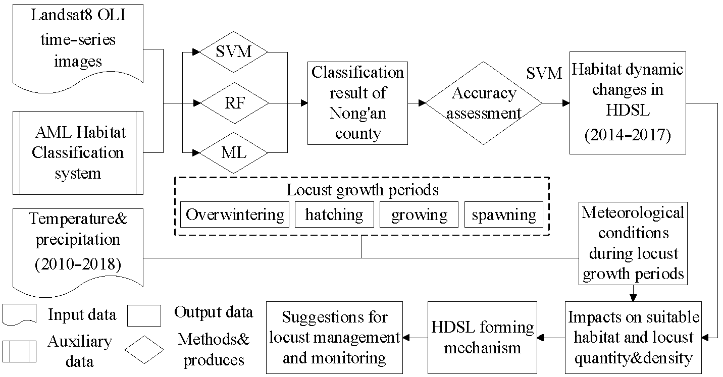
2. Materials and Methods
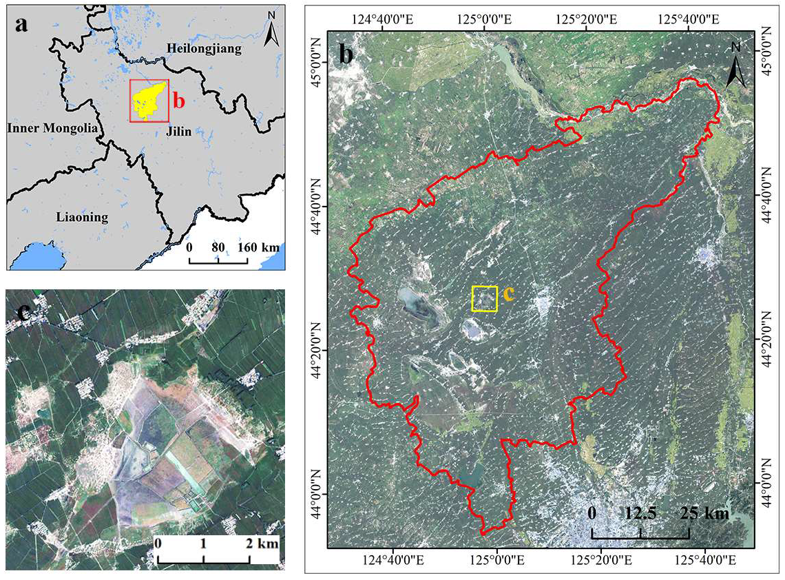
2.1. Study Area

The study area is located in Nong’an County of Jilin Province (Figure 1a), 124°31′ E~125°45′ E, 43°55′ N~44°55′ N, which lies in the Northern Hemisphere with a monsoon climate of medium latitudes and has four distinctive seasons. The average annual temperature is 4.7 °C, and the annual precipitation is 507.7 mm [29], with less rainfall in January and more in July. Meadow soil, swamp soil, alluvial soil, saline-alkali soil, and aeolian sand soil are distributed in the study area, of which swamp soil, alkaline soil, and meadow soil are suitable for the oviposition of AML. Furthermore, lakes, bubble ponds, reservoirs, and other water are scattered in the study area (Figure 1b). Sufficient water provides a suitable growth environment for the reed, which is the main habitat and food source of the AML. Based on the above analysis, the study area has a suitable environment for AML breeding. In addition, Nong’an County has a large area of cropland. A locust outbreak will cause serious damage to agriculture.
In 2017, a high-density AML outbreak occurred in the Yuanbao pool of Nong’an County (Figure 1c). The total area of locust plague is 2333.33 hm2, of which the high-density spot is 773.33 hm2. The average locust density is 100–200/m2, with densities that can reach up to 1000/m2. This paper selected an area of 41,409 hm2 around the Yuanbao pool as the HDSL (Figure 1c). There is a large area of reed in the Yuanbao pool, and the biomass can meet the demand for AML propagation. In addition, the soil is mainly alkali, while livestock, poultry, and aquaculture are scattered in the area. In summary, the Yuanbao pool has a suitable environment for locust spawning and living, and it is difficult for plant protection departments to determine when locust outbreaks occur.

2.2. Data Source and Preprocessing

Considering cloud cover, time, and coverage, Landsat 8 OLI data were selected as the basic image. According to the growing and developing period of the AML in northeast China, the images during the locust hatching or growing period (May to June) from 2014 to 2017 were selected. Finally, the images (path: 118, row: 29) of 4 June 2014, 16 June 2015, 17 May 2016, and 11 May 2017 were used in the classification. To explore the feasibility of the three methods in monitoring locust habitat, the image on 11 May 2017, which is nearest to the high-density locust occurrence time, was applied to classify the whole study area habitat. The other images were used to monitor the habitat in the HDSL. Images were preprocessed by radiometric correction, atmospheric correction, and masking before habitat classification.
Tropical Rainfall Measuring Mission satellite (TRMM) data were used to obtain monthly precipitation in the study area from 2000 to 2018. Simultaneously, ERA5_LAND data produced by the European Centre for Medium-Range Weather Forecasts were applied to obtain the monthly temperature from 2000 to 2018 in the study area. In addition, high-resolution Google Earth images were used to assist with selecting samples.

2.3. Methods

The flowchart in Figure 2 demonstrates our methodology. It shows our analytical method and the data used during each process. First, the habitat classification system of AML was established, and then SVM, RF, and ML methods were applied to explore the most suitable habitat classification method. Then, habitat dynamic changes in the HDSL from 2014 to 2017 were monitored by the most suitable method. Finally, combining the temperature and precipitation data from 2010 to 2018, this paper analyzed the HDSL forming mechanism.

2.3.1. Establishment of the Habitat Classification System

The largest proportion of habitat in Nong’an County is cropland, where rice, corn, potato, and soybean are mainly grown. AML rarely breeds in farmland affected by years of regular farming, but it is also necessary to prevent locusts from migrating to farmland and eating crops. In this study, lakes, ponds, and reservoirs are scattered and surrounded by large areas of reed, the annual vegetation of Gramineae, the main food source for AML, of which sparse reed is most suitable for locust breeding [30]. In addition, under the combined influence of surface water, groundwater, and climatic conditions, the most distributed soil type in the study area is alkali, which contains high salinity with little vegetation or some weeds. Some of them were developed for cropland, but they were regarded as abandoned cropland due to the low yield [31]. This paper classified them as barren land. Meanwhile, roads, towns, villages, and farms are considered artificial surface.
The AML habitat classification system established in this study includes five habitat categories: reed, barren land, cropland, water, and artificial surface, of which reed and barren land are the most suitable habitat, cropland is occasionally suitable habitat, and the others are non-suitable habitat. The classification system is reasonably constructed, including the frequent, occasional, and non-occurrence areas of AML (Table 1).

2.3.2. Habitat Classification Methods

To explore the most suitable method for AML classification, the SVM [32], the RF [33], and the classical ML method were applied to classify locust habitats. First, to reduce the band redundancy and improve the classification accuracy, this study took the optimal index factor (OIF) and correlation coefficient [34] as the discrimination index of data redundancy and selected the band with the minimum correlation and the maximum OIF index to participate in classification. Through calculation, this paper found that the red band (band 4), the near-infrared band (band 5), and shortwave infrared band 1 (band 6) were most suitable for simultaneous classification. Furthermore, vegetation is the main food source and suitable living environment for locusts [35,36,37], and NDVI is the best factor to reflect the vegetation health situation [38], so this study took NDVI as a band to be a part of the classification. In summary, the final features involved in the classification were red, near-red, shortwave infrared band 1, and NDVI. Then, based on the AML habitat classification system established in Section 2.3.1, ENVI was used to select samples of each habitat. The samples selected for each habitat are shown in Table 2, for a total of 2635 samples. Among them, 30% were used as test data, and 70% were used as training data. Finally, the SVM and RF methods were implemented in Python 3.8, and the ML method was classified in ENVI.
In this paper, the error matrix on sample method was applied to verify the accuracy of the three classification methods, while producer accuracy (PA), user accuracy (UA), and kappa coefficient were selected as indices to evaluate the classification results.

2.3.3. Analysis of Meteorological Conditions

Locust plagues share a close relationship with meteorological conditions, among which temperature and precipitation are the two main factors that affect AML oviposition and propagation. To further analyze the HDSL forming mechanism in Nong’an, the monthly average temperature and precipitation data from 2010 to 2018 were selected to determine their influence on the growth of AML. According to AML growth and reproduction characteristics in northeast China, the relationship between temperature and precipitation and each growth period, including the overwintering period (December to February), the hatching period (March to May), the growing period (June to July), and the spawning period (August to September), was analyzed, providing meteorological support for analyzing the HDSL forming mechanism.

3. Results

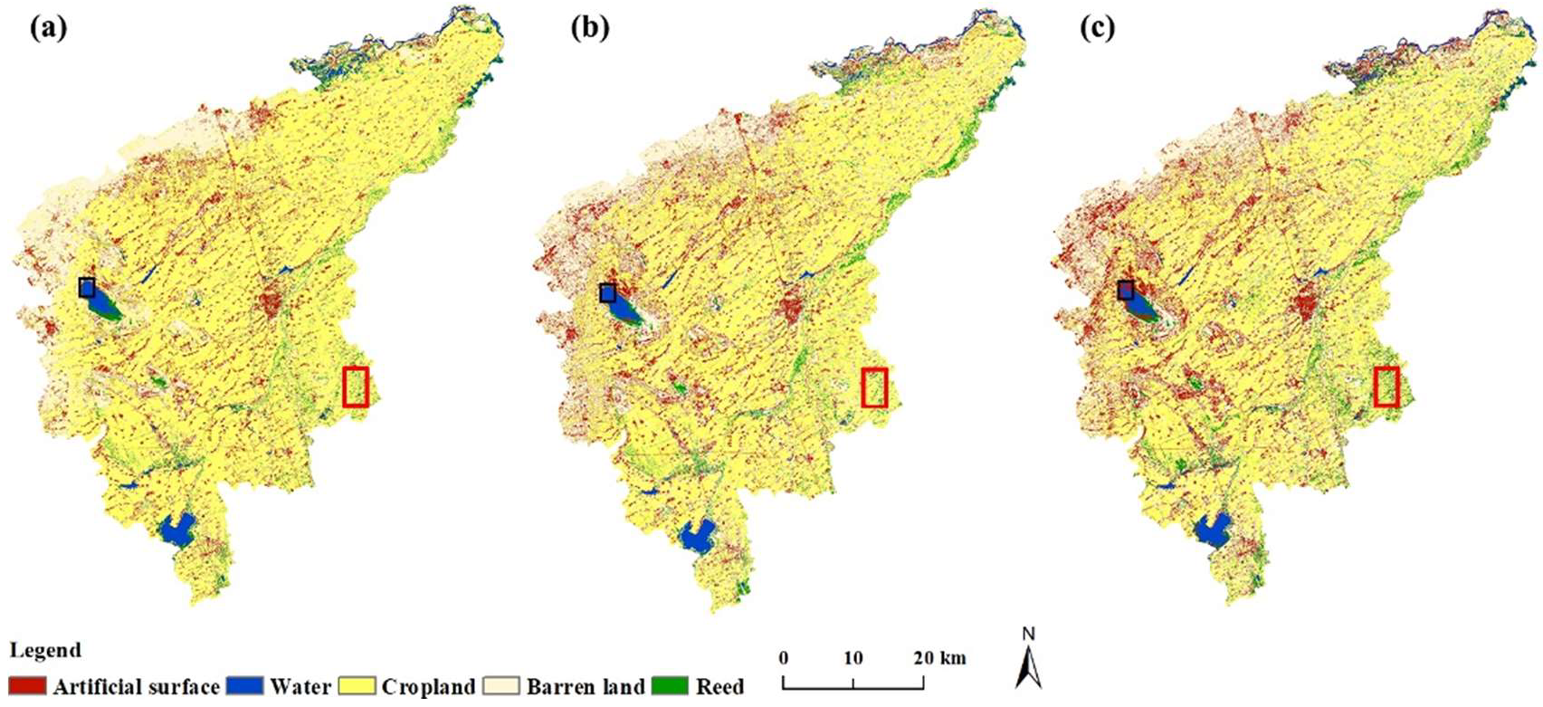
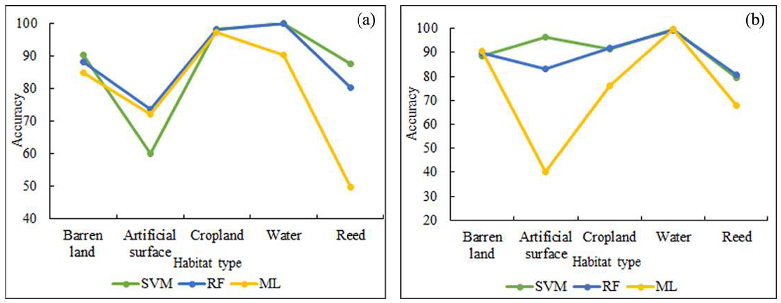
3.1. Habitat Classification Results of Nong’an County

The classification results are shown in Figure 3. According to the verification accuracy results (Table 3), this paper found that the SVM method performed best, with an overall accuracy of 95.28% and a kappa coefficient of 0.93. The RF had an accuracy of 95.03%, and the kappa coefficient was 0.92. The ML method performed worst, with an accuracy of 86.76% and a kappa coefficient of 0.80. The classification accuracy might be higher due to the lack of field survey data, but the test and training data of the three methods were the same. Therefore, the difference between the three methods could represent each method’s advantages and disadvantages.
The overall accuracy can only reflect the overall performance but cannot represent single habitat accuracy among all methods. Therefore, this research calculated the PA and the UA of a single habitat (Figure 4). For water, the ML method performed worse than the RF and SVM methods. For example, as shown in the black rectangle in Figure 3, the water was classified as the artificial surface in the ML method. For barren land and reed, the main suitable habitat for AML, the SVM method had obvious advantages over the RF and ML methods. Using the example of the cropland classification result, the ML and SVM methods misclassified cropland into reed (red rectangle in Figure 3). For the artificial surface, the accuracy of the RF method was higher than that of the other methods, but the artificial surface is not suitable for locust breeding. In summary, the SVM method performed best, either for the overall accuracy or single habitat accuracy of the AML suitable habitat.
Furthermore, the SVM is classified from low- to high-dimension, which is suitable for small samples, making it applicable for this research. The RF method classified each type based on the principle of establishing multi-independent decision trees, and the classification results were generated by the voting of each decision tree [39,40], which can reduce the error and result in better classification. Therefore, it can better distinguish habitats with similar features. The SVM method would appear to be an overfitting phoneme if the habitat had similar band characteristics, resulting in worse performance. In this study, the artificial surface had a similar band spectrum to part of the barren land, which caused lower accuracy in the SVM method. The ML method classified habitat according to the grey value. As a consequence, it could not distinguish objects with the same grey value.
In summary, the SVM method performed best both overall and on the classification of the most suitable single habitats, reed, and barren land. Therefore, it is being applied in further habitat dynamic monitoring.

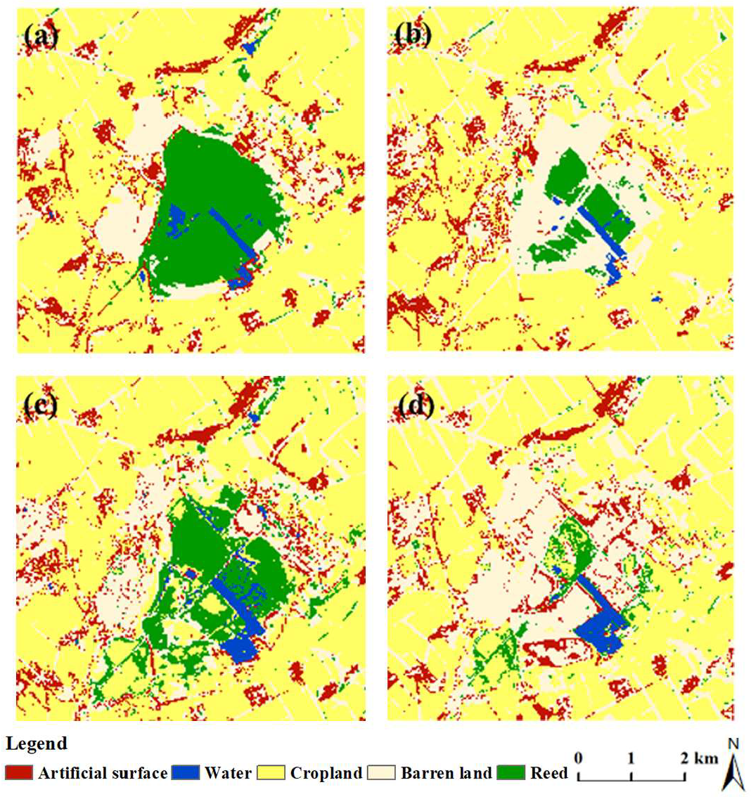
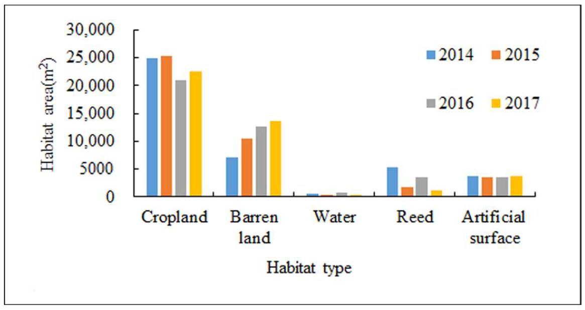
3.2. Time-Series Habitat Classification Results of HDSL

Based on the SVM method, this paper monitored dynamic locust habitat changes during the hatching or growing period from 2014 to 2017 in HDSL (Figure 5). The accuracy is shown in Table 4. The monitor results all had an accuracy of over 90%. Meanwhile, this paper calculated each habitat area from 2014 to 2017 according to the results (Figure 6).
Figure 5 shows that the habitat in HDSL was complex and was surrounded by large areas of cropland. Subsequently, some water was scattered in the central Yuanbaowa pool, which was surrounded by an amount of reed, demonstrating a trend of fluctuation due to climate change, outside which some barren land was distributed. Figure 5a–d show the dynamic habitat changes. From Figure 5a, we can see that in HDSL, there was a large area of reed surrounded by barren land. Because of dense vegetation and lack of sufficient light, the reed was not suitable for locusts to oviposit. Under this condition, only a few areas were suitable for locust propagation. In 2015, the reed decreased significantly and turned into barren land. Compared with 2014, the barren land area increased by 8.24%, providing more spawning places for the AML. Meanwhile, a certain amount of reeds could provide sufficient food for locusts. Therefore, the habitat conditions were conducive to locust reproduction (Figure 5b). In 2016, the increase in water area resulted in reed regrowth. However, the cropland turned into the barren land, so the propagation area remained at a high level, which still provided sufficient place for locusts to breed (Figure 5c). In 2017, the reed area decreased significantly and turned into the barren land, further expanding the suitable living environment for locusts. As presented by the statistical data of each habitat area, from 2014 to 2017, the reed showed a fluctuating trend, from 12% in 2014 to 4% in 2015 and then to 8% in 2016. However, the total amount of reed could still meet the demand for locust growth. The barren land has increased yearly, accounting for 17.05% in 2014, which increased to 32.92% in 2017, so the expansion of barren land was responsible for the increment of AML. In 2017, the reed area decreased (accounting for 2.84%) and became barren land with low vegetation coverage. With the continuous expansion of suitable environments, the quantity of locusts increased further.
In summary, the expanding barren land allowed the area of the living environment for locusts to continuously increase, and enough reeds provided sufficient food for locusts, which provided suitable conditions for the growth of locust quantity and density.

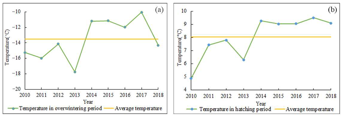
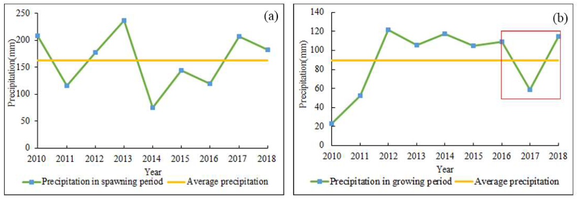
3.3. Meteorological Factor Analysis from 2010 to 2018

Temperature and precipitation are the key meteorological factors that affect AML growth and development. By analyzing temperature and precipitation data in the study area from 2010 to 2018, it was found that the meteorological conditions from 2014 to 2017 were suitable for AML development and growth.
AML has strong cold resistance [41]. Considering its insensitivity to low temperature, the average temperature in the overwintering period from 2010 to 2018, rather than the minimum temperature, was selected as the reference index. By analyzing the temperature data of key growth periods, the results showed that the temperature in the overwintering period from 2014 to 2017 was higher than the 2010–2018 average (Figure 7a). The higher temperature during the overwintering period accounted for the higher spawn survival rate. The result also demonstrated that the temperature in the hatching period (March to May) was also higher than the 2010–2018 average (Figure 7b), of which the temperature was the highest in 2017. During the hatching period, the higher temperature was conducive to the survival of locust spawns.
By analyzing the rainfall in each key growth period of the AML, it was found that the precipitation in the spawning period (August) from 2014 to 2016 was lower than the 2010–2018 average (Figure 8a). Locust spawn can become moldy and die under damp conditions, while drought conditions are conducive to the survival of locust spawn during the spawning period [41]. In 2017, the precipitation was 30.8 mm lower than the average from 2010 to 2018 during the growing period (Figure 8b). Drought conditions improved the survival rate of locust eggs. This paper also found that during the growing period, the rainfall before and after the locust plague showed a “3V”-shaped fluctuation (red rectangle in Figure 8b) [42]. The “3V”-shaped fluctuation means that the rainfall increased before the year of the locust plague and decreased sharply in the year of the plague, which was conducive to the forming of HDSL.

4. Discussion

4.1. Analysis of the HDSL Forming Mechanism

Analysis of the meteorological conditions and habitat changes showed that suitable habitat and meteorological conditions could promote the formation of the high-density spot of AML.
In 2014, a large area of reeds was distributed in the HDSL, but the dense vegetation inside the reeds lacked sufficient light, so it was not suitable for the activities of AML [43]. Therefore, the habitat conditions were not ideal for locust growth. However, compared with 2013, the temperature increased significantly during the overwintering and hatching periods, and the precipitation was lower than the average of the most recent 10 years during the spawning period. The higher temperature and lower precipitation could improve the spawn survival rate, leading to the reproduction of locusts. Kong et al. demonstrated that the warm winter is conducive to oriental migratory locust outbreaks in Henan province [44]. In fact, AML and oriental migratory locusts belong to one subspecies, so they have similar characteristics. Therefore, it can be indirectly proven that higher temperatures can improve the spawn survival rate results. In 2012, Zhang et al. clarified AML ecological characteristics in northeast China. The results also implied that less precipitation during the spawning period is conducive to AML spawning in northeast China [45]. The same locusts have similar characteristics in similar regions, so this can prove that the result that less precipitation during the spawning period is beneficial for AML growth is reasonable. Based on the above analysis, in 2014, few AMLs grew in the Yuanbaowa pool. In 2015, a large area of reed was transformed into the barren land, which provided sufficient space for AML to spawn. Additionally, the temperature was appropriate in the overwintering period and hatching period, while the precipitation in the spawning period was also suitable. At this time, the expanding suitable habitat and meteorological conditions worked together, resulting in the continuous expansion of the AML quantity. In 2016, more precipitation during the hatching period led to a rising water level. Sufficient water was conducive to the regrowth of reeds, which provided an adequate source of food for a large number of locusts. The suitable habitat, temperature during overwintering and hatching, and precipitation during spawning were beneficial for locusts. In 2016, the quantity and density of locusts increased further due to the influence of both habitat and meteorological conditions. In 2017, there was less precipitation during the growing period, during which the arid meteorological conditions could improve the hatching rate. Xiong et al. analyzed the AML outbreak reasons in northeast China and they also illustrated that the drought environment is the key factor that led to the AML outbreak [46]. Meanwhile, more areas of reed and water were morphed into the barren land, and appropriate meteorological conditions promoted the spawning rate and hatching rate. Affected by both meteorological conditions and expanded suitable habitat, the quantity and density of AML continuously increased.
In summary, due to the suitable conditions, complex habitats in the HDSL, and less human intervention, it was difficult for the plant protection departments to monitor AML in time, resulting in the continuous accumulation of locusts, leading to the forming of HDSL.

4.2. Suggestions for Locust Management and Monitoring

Analysis of the HDSL forming mechanism coupled with the dynamic changes in habitat types and meteorological conditions is of great significance for finding potential outbreak areas and ensuring food security. Compared with the traditional empirical locust survey method based on artificial point field surveys conducted by local plant protection staff, using remote sensing technology to dynamically monitor the AML habitat has the characteristics of a large area, high efficiency, and high accuracy. The habitat monitoring results can be used for finding locust infestation risk regions to guide field survey investigators in identifying locations of locust reproduction [4]. Chemical pesticide treatments could then be guided and optimized by concentrating on regions with a high risk of locust infestation.
In addition, analysis of meteorological conditions during the locust growth period could estimate the spawn rate. Plant protection departments should pay more attention to the meteorological conditions that suit locust growth, such as higher temperatures during the overwintering and hatching periods or less precipitation during the growing or spawning period. Furthermore, the combination of habitat changes and meteorological conditions can provide better theoretical guidance for the early prevention of locust plague, which is of great significance for indicating the key locust control areas, and detecting new locust-suitable habitats in time, accomplishing the precise control of AML, and ensuring food security.
Different measures should be implemented in different types of locust-suitable habitats. Reed, especially with 30–50% vegetation coverage, usually appears in low-lying and poorly drained regions and is a suitable breeding environment for locusts [47]. The high density of reeds is harmful to locust breeding, so enriching the sparse reed density is considered a functional measure. Barren land, which accounted for a large proportion of the study area, was the key area of prevention and control. It can be rectified according to the specific types: for the stacked wasteland, it should be ploughed again in a calculated way to eliminate the special environment; secondly, we should pay attention to developing water conservancy, improving farmland capital construction, and reducing damage; for severely saline-alkaline land, soil quality can be ameliorated by using soil improvement and remediation technology, such as applying alkaline soil improver, making full use of local livestock, poultry manure, and straw resources to accumulate organic fertilizer, and increasing soil fertility.

5. Conclusions

Locust habitat monitoring and forming mechanism analysis can identify potential locust breeding areas, which is of great significance for the early prevention of plague. This paper explored the ability of Landsat 8 data in locust habitat monitoring and forming mechanism analysis. SVM, RF, and ML classification methods were applied to the habitat classification of AML, and the most suitable method was used to monitor habitat dynamic changes in HDSL from 2014 to 2017. Furthermore, this research combined temperature and precipitation data to define forming mechanisms of HDSL. We draw the following conclusions: (1) The SVM method performed better for AML habitat classification than the ML method and the RF method, especially in locust main breeding habitats. (2) By monitoring habitat dynamics, this paper finds that the increase in the amount of reed and barren land is related to the forming of high-density locust outbreaks. (3) During the overwintering and hatching period, the temperatures were higher than the 2010–2018 average from 2014 to 2016, which improved the locust spawn survival rate. In addition, during the spawning period from 2014 to 2016, the precipitation was less than the 2010–2018 average, and in 2017, during the growing period, the precipitation was 30.8 mm less than the 2010–2018 average and had a “3V”-shaped fluctuation, which was latently responsible for the forming of HDSL. This study defined the HDSL forming mechanism in northeast China, which was instrumental for identifying locust potential areas and ensuring food security.

Author Contributions

Conceptualization, J.G. and L.Z.; methodology, L.Z. and W.H.; software, Y.G.; validation, J.G., L.Z., W.H., Y.D. and Y.G.; formal analysis, J.G.; investigation, J.G. and L.Z.; resources, L.Z.; data curation, W.H.; writing—original draft preparation, J.G.; writing—review and editing, J.G., L.Z. and Y.D.; visualization, W.H.; supervision, W.H.; project administration, L.Z. and W.H.; funding acquisition, W.H. All authors have read and agreed to the published version of the manuscript.

Funding

This research was funded by the Open Research Fund of Key Laboratory of Digital Earth Science, Chinese Academy of Sciences (Grant No. 2020LDE003), the National Natural Science Foundation of China (Grant No. 42171323), Chinese Academy of Sciences (Grant No. 183611KYSB20200080), Alliance of International Science Organizations (Grant No. ANSO-CR-KP-2021-06), Beijing Nova Program of Science and Technology (Grant No. Z191100001119089).

Data Availability Statement

All the data used in this study are available publicly. The Landsat 8 OLI data are available from https://earthexplorer.usgs.gov/ (accessed on 11 November 2020); the temperature data are available from European Centre for Medium-Range Weather Forecasts (https://www.ecmwf.int/en/forecasts/datasets) (accessed on 1 June 2021); the precipitation data are available from Tropical Rainfall Measuring Mission satellite (https://disc.gsfc.nasa.gov/datasets?page=1&project=TRMM) (accessed on 1 June 2021).

Acknowledgments

The authors would like to sincerely thank Huichun Ye, Ruiqi Sun, and Binxiang Qian for their help with the study. We also thank the academic editors and reviewers for their insightful comments which greatly helped us improve the quality of this manuscript.

Conflicts of Interest

The authors declare no conflict of interest.

References

  1. Zhang, Z.D.; Mei, S.G.; Wang, X.R.; Yuan, F.X.; Xu, Z.; Guo, X.F.; Zhang, L.Y. Occurring characteristics of Locusta migratoria and analyses on its causes in Jilin province in 2017. China Plant Prot. 2017, 37, 40–43. (In Chinese) [Google Scholar]
  2. Therville, C.; Anderies, J.M.; Lecoq, M.; Cease, A. Locusts and People: Integrating the Social Sciences in Sustainable Locust Management. Agronomy 2021, 11, 951. [Google Scholar] [CrossRef]
  3. Huang, C.; Liu, W. Characteristic analysis and Control suggestion of migratory locust in China in 10 years. China Plant Prot. 2016, 36, 49–53. (In Chinese) [Google Scholar]
  4. Zhang, L.; Lecoq, M.; Latchininsky, A.; Hunter, D. Locust and Grasshopper Management. Annu. Rev. Entomol. 2019, 64, 15–34. [Google Scholar] [CrossRef]
  5. Klein, I.; Oppelt, N.; Kuenzer, C. Application of Remote Sensing Data for Locust Research and Management—A Review. Insects 2021, 12, 233. [Google Scholar] [CrossRef] [PubMed]
  6. Yang, Q.P.; Liu, W.C.; Huang, C.; Zhu, J.Q.; Zhang, Z.D.; Zhu, J.S.; Xie, F.Z. Occurring analysis on high-density spot of Locusta migratoria and suggestions on its monitoring and controlling in China in 2017. China Plant Prot. 2018, 3, 37–47. (In Chinese) [Google Scholar]
  7. Yu, G.; Ke, X.; Shen, H.D.; Li, Y.F. An analysis of the contrasting fates of locust swarms on the plains of North America and East Asia. Biogeosciences 2013, 10, 1441–1449. [Google Scholar] [CrossRef] [Green Version]
  8. Waldner, F.; Ebbe, M.A.B.; Cressman, K.; Defourny, P. Operational Monitoring of the Desert Locust Habitat with Earth Observation: An Assessment. ISPRS. Int. J. Geo-Inf. 2015, 4, 2379–2400. [Google Scholar] [CrossRef] [Green Version]
  9. Han, J.W.M.; Hasibagan, X.Z.; Devision, T. Calibration and verification of remote sensing data for East Asia migratory plague locust reed habitat monitoring. In Proceedings of the IEEE International Geoscience and Remote Sensing Symposium (IGARSS 2002)/24th Canadian Symposium, Toronto, ON, Canada, 24–28 June 2002. [Google Scholar]
  10. Huang, W.J.; Dong, Y.Y.; Zhao, L.L.; Geng, Y.; Ruan, C.; Zhang, B.Y.; Sun, Z.X.; Zhang, H.S.; Ye, H.C.; Wang, K. Review of locust remote sensing monitoring and early warning. J. Remote Sens. 2020, 24, 1270–1279. (In Chinese) [Google Scholar] [CrossRef]
  11. Shao, Z.F.; Feng, X.X.; Bai, L.Z.; Jiao, H.M.; Zhang, Y.; Li, D.R.; Fan, H.S.; Huang, X.; Ding, Y.Q.; Altan, O.; et al. Monitoring and Predicting Desert Locust Plague Severity in Asia-Africa Using Multisource Remote Sensing Time-Series Data. IEEE J.-Stars 2021, 14, 8638–8652. [Google Scholar] [CrossRef]
  12. Tratalos, J.A.; Cheke, R.A.; Healey, R.G.; Stenseth, N.C. Desert locust populations, rainfall and climate change: Insights from phenomenological models using gridded monthly data. Clim. Res. 2010, 10, 229–239. [Google Scholar] [CrossRef]
  13. Nishide, Y.; Tanaka, S.; Saeki, S. Adaptive difference in daily timing of hatch in two locust species, Schistocerca gregaria and Locusta migratoria: The effects of thermocycles and phase polyphenism. J. Insect Physiol. 2015, 72, 79–87. [Google Scholar] [CrossRef] [PubMed]
  14. Woodman, J.D. Surviving a flood: Effects of inundation period, temperature and embryonic development stage in locust eggs. Bull Entomol. Res. 2015, 105, 441–447. [Google Scholar] [CrossRef] [PubMed] [Green Version]
  15. Jiang, J.J.; Ni, S.X.; Wei, Y.C. Knowledge Based Grasshopper Habitat Classification Approach Supported by GIS in Qinghai Lake Region. J. Remote Sens. 2002, 6, 387–392. [Google Scholar]
  16. Zheng, X.M.; Huang, J.F.; Li, H.M.; Mansaray, L.R.; Song, P.L.; Dou, Y.J. Mapping of oriental migratory locust habitat using Landsat OLI images in Dongying City, China. In Proceedings of the Name of the 7th International Conference on Agro-Geoinformatics (Agro-Geoinformatics), Hangzhou, China, 6–9 August 2018. [Google Scholar]
  17. Zhao, L.L.; Huang, W.J.; Chen, J.S.; Dong, Y.Y.; Ren, B.Y.; Geng, Y. Land use/cover changes in the Oriental migratory locust area of China: Implications for ecological control and monitoring of locust area. Agric. Ecosyst. Environ. 2020, 303, 107110. [Google Scholar] [CrossRef]
  18. Gomez, D.; Salvador, P.; Sanz, J.; Rodrigo, J.F.; Gil, J.; Casanova, J.L. Prediction of desert locust breeding areas using machine learning methods and SMOS (MIR_SMNRT2) Near Real Time product. J. Arid Environ. 2021, 194, 104599. [Google Scholar] [CrossRef]
  19. Sivanpillai, R.; Latchininsky, A.V. Mapping locust habitats in the Amudarya River Delta, Uzbekistan with multi-temporal MODIS imagery. Environ. Manag. 2007, 39, 876–886. [Google Scholar] [CrossRef]
  20. Navratil, P.; Wilps, H. Object-based locust habitat mapping using high-resolution multispectral satellite data in the southern Aral Sea basin. J. Appl. Remote Sens. 2013, 7, 075097. [Google Scholar] [CrossRef]
  21. Low, F.; Waldner, F.; Latchininsky, A.; Biradar, C.; Bolkart, M.; Colditz, R.R. Timely monitoring of Asian Migratory locust habitats in the Amudarya delta, Uzbekistan using time series of satellite remote sensing vegetation index. J. Environ. Manag. 2016, 183, 562–575. [Google Scholar] [CrossRef]
  22. Veran, S.; Simpson, S.J.; Sword, G.A.; Deveson, E.; Piry, S.; Hines, J.E.; Berthier, K. Modeling spatiotemporal dynamics of outbreaking species: Influence of environment and migration in a locust. Ecology 2015, 96, 737–748. [Google Scholar] [CrossRef] [PubMed] [Green Version]
  23. Wang, X.X.; Fan, J.L.; Zhou, M.; Gao, G.; Wei, L.Y.; Kang, L. Interactive effect of photoperiod and temperature on the induction and termination of embryonic diapause in the migratory locust. Pest Manag. Sci. 2021, 77, 2854–2862. [Google Scholar] [CrossRef]
  24. Sun, R.; Huang, W.; Dong, Y.; Zhao, L.; Zhang, B.; Ma, H.; Geng, Y.; Ruan, C.; Xing, N.; Chen, X.; et al. Dynamic Forecast of Desert Locust Presence Using Machine Learning with a Multivariate Time Lag Sliding Window Technique. Remote Sens. 2022, 14, 747. [Google Scholar] [CrossRef]
  25. Zhao, X.M. Preliminary Analysis on Occurrence and Causes of the Asian Migratory locust in Heilongjiang Province in 2009. Heilongjiang Agric. Sci. 2010, 12, 70–71. (In Chinese) [Google Scholar]
  26. Zheng, S.F.; Sun, Y.; Sun, Y.; Wang, S.X.; Wang, G.Q.; Xiao, Y. Factors of Locusta migratoria Outbreak in Songnen Plain. J. Northeast. For. Univ. 2011, 39, 98–100. [Google Scholar] [CrossRef]
  27. Kudureti. Analysis of Asian Migratory Locust occurrence and outbreak reasons in Turpan, Xinjiang province in 2019. Rural Sci. Technol. 2019, 5, 35–36. (In Chinese) [Google Scholar] [CrossRef]
  28. Propastin, P. Multisensor Monitoring System for Assessment of Locust Hazard Risk in the Lake Balkhash Drainage Basin. Environ. Manag. 2012, 50, 1234–1246. [Google Scholar] [CrossRef] [Green Version]
  29. Changes Below County-Level Administrative Divisions of the People’s Republic of China in 2016 (November). Available online: http://www.nong-an.gov.cn/info/1042/92883.htm (accessed on 9 June 2021).
  30. Scanlan, J.C.; Grant, W.E.; Hunter, D.M.; Milner, R.J. Habitat and environmental factors influencing the control of migratory locusts (Locusta migratoria) with an entomopathogenic fungus (Metarhizium anisopliae). Ecol. Model. 2001, 136, 223–236. [Google Scholar] [CrossRef]
  31. Hu, F. Research on the Renovation Planning of Saline or Alkali in the West of Jilin Based on Remote Sensing Techniques. Master’s Thesis, Jilin University, Changchun, China, 2013. (In Chinese). [Google Scholar]
  32. Gomez, D.; Salvador, P.; Sanz, J.; Casanova, C.; Taratiel, D.; Casanova, J.L. Machine learning approach to locate desert locust breeding areas based on ESA CCI soil moisture. J. Appl. Remote Sens. 2018, 12, 036011. [Google Scholar] [CrossRef] [Green Version]
  33. Geng, Y.; Zhao, L.L.; Dong, Y.Y.; Huang, W.J.; Shi, Y.; Ren, Y.; Ren, B.Y. Migratory Locust Habitat Analysis With PB-AHP Model Using Time-Series Satellite Images. IEEE Access 2020, 8, 166813–166823. [Google Scholar] [CrossRef]
  34. Zeng, Z.Y. Research on Computer Classification of Satellite Images and Application in Geoscience; Science Press: Beijing, China, 2004; p. 46. (In Chinese) [Google Scholar]
  35. Alvarez-Cobelas, M.; Cirujano, S. The vegetal benthos. In Limnologia de la Laguna de Somolinos (Guadalajara): Sintesis del Conocimiento Cientifico; SanchezCarrillo, S., Ed.; CSIC: Madrid, Spain, 2018; pp. 159–218. [Google Scholar]
  36. Dkhili, J.; Maeno, K.O.; Hassani, L.M.I.; Ghaout, S.; Piou, C. Effects of starvation and Vegetation Distribution on Locust Collective Motion. J. Insect Behav. 2019, 32, 207–217. [Google Scholar] [CrossRef]
  37. Mandjoubi, D.; Guendouz-Benrima, A.; Petit, D. Plant communities and solitary Desert Locust abundance in the Algerian Sahara, compared to other African countries. Phytocoenologia 2017, 47, 125–137. [Google Scholar] [CrossRef]
  38. Gonenc, A.; Ozerdem, M.S.; Acar, E. Comparison of NDVI and RVI Vegetation Indices Using Satellite Images. In Proceedings of the 2019 8th International Conference on Agro-Geoinformatics (Agro-Geoinformatics), Istanbul, Turkey, 16–19 July 2019. [Google Scholar]
  39. Khan, Z.; Gul, A.; Perperoglou, A.; Miftahuddin, M.; Mahmoud, O.; Adler, W.; Lausen, B. Ensemble of optimal trees, random forest and random projection ensemble classification. Adv. Data Anal. Classif. 2020, 14, 97–116. [Google Scholar] [CrossRef] [Green Version]
  40. Hatwell, J.; Gaber, M.M.; Azad, R.M.A. CHIRPS: Explaining random forest classification. Artif. Intell. Rev. 2020, 53, 5747–5788. [Google Scholar] [CrossRef]
  41. Li, M. The Biologicial Characteristics of Locusta migratoria Migratoria and Ecological-Environment Character of the Locust Plague Area in Jinlin Province. Master’s Thesis, Northeast Normal University, ‎Changchun, China, May 2012. [Google Scholar]
  42. Huang, W.J.; Huang, Q.L.; Li, C. Analysis of climatic factors of forming of Asiatic migratory locust firestorm in Xinjiang boteng lake. J. Catastophol. 2005, 20, 84–87. [Google Scholar]
  43. Zhu, E. The Management of the Oriental Migratory Locust in China; China Agriculture Press: Beijing, China, 1999; pp. 45–60. (In Chinese) [Google Scholar]
  44. Kong, H.; Lu, W.; Lu, G.; Wang, X.; Wang, J. Effect of Drought and Higher Temperature on the Outbreaks of the Oriental Migratory Locust in He’nan Province. J. Nanjing Inst. Meteorol. 2003, 26, 516–524. [Google Scholar]
  45. Zhang, X.; Miao, H.; Fu, Z.; Han, Y.; Wang, G.; Ren, B. The Ecological Environment Characters of Locusta migratoria migratoria Linnaeus Plague Area in Northeast China. J. Jilin Agric. Univ. 2012, 34, 522–526. (In Chinese) [Google Scholar]
  46. Xiong, Y.; Chen, J.; Gong, X.; Guo, R.; Wang, W. A Preliminary Study on the Causes of the 2009 Asian migratory locust Outbreak in Heilongjiang and Countermeasures for Prevention and Control. China Plant Prot. 2009, 3, 25–26. (In Chinese) [Google Scholar]
  47. Shi, Y.; Huang, W.J.; Dong, Y.Y.; Peng, D.L.; Zheng, Q.; Yang, P.Y. The influence of landscape’s dynamics on the Oriental Migratory Locust habitat change based on the time-series satellite data. J. Environ. Manag. 2018, 218, 280–290. [Google Scholar] [CrossRef]
Figure 1. (a) Location of the study area in Jilin Province; the yellow area represents Nong’an County; (b) true–color composite image of the study area based on Landsat OLI; the red line represents the boundary of Nong’an County; (c) the Yuanbao pool where a high-density locust outbreak occurred.
Agronomy 12 01610 g001
Figure 2. Flowchart of the forming mechanism of the high-density spot of locust. AML, Asian migratory locust; SVM, support vector machine; RF, random forest; ML, maximum likelihood; HDSL, high-density spot of locust.
Agronomy 12 01610 g002
Figure 3. Habitat classification results. (a) SVM; (b) RF; (c) ML.
Agronomy 12 01610 g003
Figure 4. Classification accuracy for the single habitat of the three methods. (a) PA; (b) UA.
Agronomy 12 01610 g004
Figure 5. Habitat dynamic changes in HDSL from 2014 to 2017: (a) 2014; (b) 2015; (c) 2016; (d) 2017.
Agronomy 12 01610 g005
Figure 6. Statistics of habitat area from 2014 to 2017 in HDSL.
Agronomy 12 01610 g006
Figure 7. (a) Overwintering period (December to February) temperature from 2010 to 2018; (b) hatching period (March to May) temperature from 2010 to 2018.
Agronomy 12 01610 g007
Figure 8. (a) Spawning period (August) precipitation from 2000 to 2018; (b) growing period (June) precipitation from 2010 to 2018.
Agronomy 12 01610 g008
Table 1. Habitat classification system of AML.
Habitat ClassDescription
ReedReed and other grass on wet or semi-dry soil, mostly Phragmites australis reed, and mixed with Cyperus rotundus and Digitaria Sanguinalis. The vegetation conditions provide abundant food for locusts. The low-density regions (vegetation coverage 35–55%) are optimal for nymph growth, and the middle-density regions (vegetation coverage 55–75%) are good for locust sustainability and growth. The high-density regions are not suitable for locust breeding.
Barren landMostly alkali soil, with less vegetation coverage or fewer weeds. Some of them were developed for cropland, but they were regarded as abandoned cropland due to the low yield. In this system, the barren land with less human intervention and vegetation coverage provides an ideal environment for locust oviposition.
CroplandMostly rice, corn, potato, and soybean. Owing to regular manual management, such as ploughing and irrigation, the field conditions are not suitable for locust breeding or oviposition, but the crops with exuberant growth provide an option for locust immigration.
WaterIncluding lakes, ponds, and reservoirs. The water resources are associated with soil moisture and temperature, which further influences the surrounding vegetation growth.
Artificial surfaceIncluding roads, towns, villages, and farms. It is not suitable for locust breeding.
Table 2. Sample number of each habitat.
Habitat ClassReedBarren LandCroplandArtificial SurfaceWater
Sample’s number152839930400314
Table 3. Overall accuracy and kappa coefficient of the three classification methods.
Evaluation IndexSVMRFML
Overall accuracy (%)95.2895.0386.76
Kappa coefficient (%)0.930.920.80
Table 4. Overall accuracy and kappa coefficient of HDSL from 2014 to 2017.
Evaluation Index2014201520162017
Overall accuracy (%)97.5490.8493.3895.28
Kappa coefficient (%)0.960.880.920.93
Publisher’s Note: MDPI stays neutral with regard to jurisdictional claims in published maps and institutional affiliations.

