1. Introduction
The term “weeds” refers to “plants suitable for habitats modified by man and that interfere with human activities” [
1]. It implies an anthropocentric rather than an ecological vision [
2], since the existence and the characteristic of the interference depend on men’s purposes.
Interference leads to a hazard with associated damage, and it is rarely related to a single species or individual, but to a “weed community”, defined as “a set of individuals found in a survey at a given instant and in a physically delimited space” [
3].
In agroecosystems, the main hazards related to the weeds are due to the competition with crops, mainly affected by the time of emergence, the density of plants, and the traits of the species [
4]. The resulting damages are precisely quantifiable because they concern the yield, which is a quantitative variable.
In non-agricultural areas, they involve general considerations, such as unsightliness, functional damage, and public health [
5].
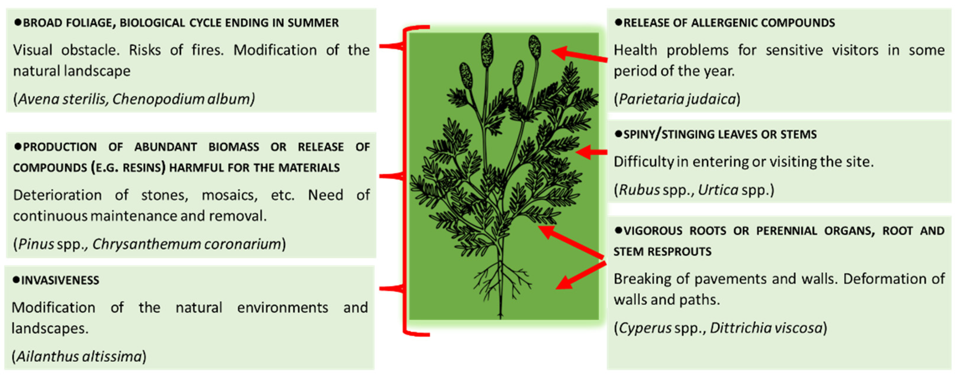
In the archaeological sites, areas managed and frequented by people, weeds pose hazards to the stability and conservation of the structures (see, for example, [
6,
7]) or they involve general impacts, such as those pertinent to the management and use of the site; in
Figure 1, we report an example scheme, although many other examples could be provided in relation to the specific characteristics of the site.
In order to understand the possible impact of weeds both on a crop and on any site of human interest, we must know both abundance and characteristics of the occurring species. The mere quantification of the plant abundance is insufficient to describe the hazard to which a given infested site is subjected. It is therefore necessary to have a greater degree of detail, combining the structure of the weed community with the characteristics of each detected species.
There are several methods to quantify the magnitude of the infestation [
8]. For example, it could be possible to count the number of individuals (plant density) growing in a sampling plot or estimate it according to density classes [
9]. In these cases, the information is not complete since the size of the plants is lacking; thus, it is possible also to weigh the biomass, although it is a time-consuming method. Another very commonly used measure is the estimation of plant cover, accounting for its quickness although it lacks information about the number of individuals.
The method proposed by Braun-Blanquet [
10] was developed to carry out phytosociological and ecological investigations; however, it is also widely used by weed scientists to describe the infestation in the fields or to compare the effectiveness of different management techniques (see below,
Section 2).
In addition to the extent of the infestation, the severity of the hazard is related to morphological and eco-physiological characteristics that vary according to the botanical species. For example, a single plant of
Fumaria capreolata L. does not exert the same damage as a single plant of
Dittrichia viscosa (L.) Greuther: indeed, the first species is gracile with tiny roots [
11], while the second is a perennial vigorous plant and can emit many sprouts [
12]. However, the denser the population, the greater the damage, up to the point that the effect of different species with different traits could be, in many cases, equaled. This effect has been described by many authors for several crops, taking yield as a parameter to indicate the extent of damage caused by weeds [
13].
Regarding the hazard for structures in archaeological sites, one of the indexes used for estimating the weed impact is the Hazard Index (HI) proposed by Signorini [
14] whose criteria are reported in
Table S1.
The method is limited to the evaluation of the potential or actual mechanical impact of the plant, related to the structural layout of the infested site or monument, while the other general negative impacts are not considered. Moreover, it has been argued [
15] that HI does not take into account the abundance of each species, therefore, it does not allow possible a quantitative hazard assessment of the flora. To remedy this lack, the authors suggest a new, more complete index (Deteriogenic Index) which, however, still considers only the structural damage.
Since weeds are always a potentially harmful component in any area of human interest (both agroecosystems and non-agricultural areas), there is a need to provide a tool capable of fully describing their impact, considering also other critical issues related to the general concept of “weed”, also referring to properly agronomic concepts. The present manuscript reports a case study on archaeological sites that are areas of cultural interest.
Research Aim
Based on our knowledge, the scientific bibliography contains scarce information regarding the complete and comparable assessment of the hazards and thus of the damages that a weed community can lead to in sites of historical and archaeological interest.
The aim of the present work was to try to identify and propose a method for weed community analysis in archaeological sites to:
Quantify the degree of the infestation, in terms of occurring species.
Quantify the related hazard based on some characteristics of the weed community.
Propose indexes capable of providing synthetic and comparable information on the hazard to which a site is exposed.
The proposed method was applied and tested in some sites of archaeological interest in the Apulia Region (southern Italy).
2. Materials and Methods
2.1. Archaeological Sites
Five sites located in the Apulia Region (Italy) were surveyed during the Spring 2016, that is, in the period of maximum vegetative growth (
Table 1). With concern to the general structural characteristics (useful for the purposes of this work), in all sites, the main finds consisted of dry stonewalls, that is, what remained of ancient buildings (houses, churches, theatres, etc.). In the case of EGN and CAB, there were also sepulchral areas, currently evident due to the presence of burial pits. The EGN site also presented the remains of the ancient Roman Via Traiana and its stone pavement.
The sites could be visited along roads paved with beaten earth or with gravel. Only in the SSI site, the main find consisted of an elliptical building built in dry stone.
In all sites, the presence of large surrounding unpaved spaces in which spontaneous vegetation could grow undisturbed was observed. These spaces also constituted a source of seed and propagule dispersal for the areas close to the finds.
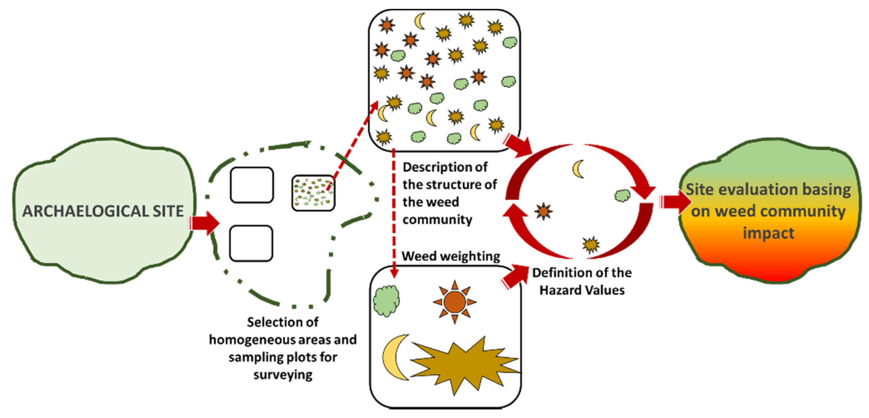
2.2. Procedure Followed
For each archaeological site, the following step-by-step procedure was tested in order to describe the weed community and its possible negative impact:
Homogeneous areas selection for surveying.
Description of the structure of the weed community.
Weed weighting.
Definition of Hazard Values.
Site evaluation based on weed community impact.
A schematic representation of the procedure is shown in
Figure 2, while a list of the abbreviations used and their explanation is shown in
Table 2.
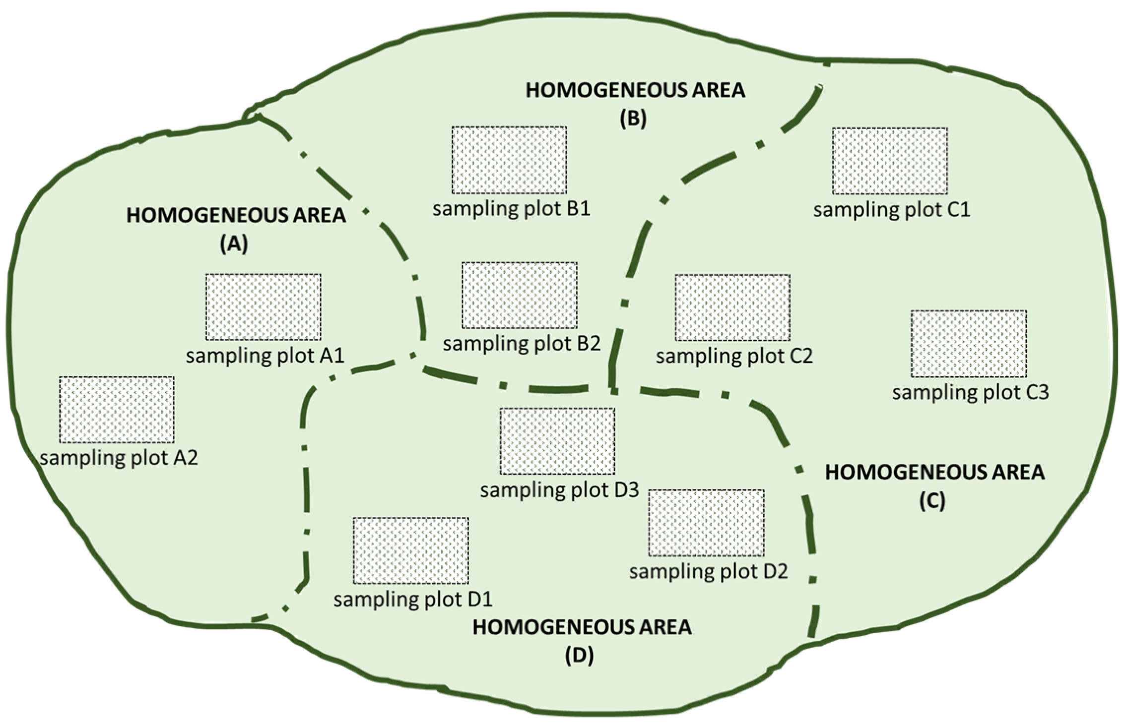
2.3. Homogeneous Areas Selection for Surveying
This first step had the purpose to cover all the different situations present in the surveyed site. Each site was divided into several homogeneous areas (HoA); the selection of the areas was made on the basis of a visual evaluation and according to variable characteristics for each site (e.g., type of structures present, exposure, use). For example, the presence of long walls, paving stones, or large open spaces were considered characteristics for the definition of different homogeneous areas.
In each of them, several sampling plots (SaP) were selected, before carrying out the floristic surveys. Each SaP was around 30 m
2, whereas its number per each HoA was defined according to its dimensions. In
Figure 3, an example of the choice of the HoA and SaS is shown.
In order to make the presentation of the procedure clearer, only the results obtained in one selected HoA for each site are reported. In these areas, we have found the most significant results and they best represent the objectives of the proposed procedure.
2.4. Description of the Structure of the Weed Community
The species occurring in each SaS were recorded and listed. An index of abundance-dominance was assigned to each detected species, according to the Braun-Blanquet method [
10].
The method assumes that a species can occupy the same space either with numerous small individuals or with fewer, but wider individuals. A different index is visually assigned to each species of the community according to their abundance and cover. In order to treat the data algebraically (sums and averages), it is very often necessary to transform this discrete scale into continuous values. Several methods are proposed [
16], although the most common is to use the midpoints of each cover interval [
17].
Table 3 summarizes the criteria for assigning the discrete indexes and the relative midpoints used for their transformation.
The numerical information provided is described below:
Total cover (Tc), as the sum of the covers of every single species (Sc) to have first information about how the site was infested. The value can exceed 100% as plants can grow on several layers.
Total cover of all species grouped according to Raunkiaer’s plant life form classification [
18], namely Therophytes, Hemicryptophytes, Chamaephytes, Phanerophytes, Geophytes. This procedure gave useful information about the type of vegetation occurring in the site; for example, if it was dominated by herbaceous plants, trees, or shrubs, or also by perennial or annual plants.
Species richness (Sr), that is, the total number of taxa found on the site. This value had to be evaluated together with the Shannon Index described below.
Shannon Diversity Index (Sh) was calculated to detect if the community was dominated by only a few species. In surveys conducted for several years, with the same number of species, a lower value of the index can be an indication of shifting toward a population dominated by only a few species.
In agroecosystems, this Index has been reported to be a reliable indicator of the effects of weed control practice on the structure of the flora community [
19]. Particularly, a weed community dominated by a few species may have been selected by continuous use of a single control technique and it could be very difficult or impossible to manage, due to the presence of species highly tolerant to that technique. The index was calculated following the formula: −∑(Sc
i/Tc) × ln(Sc
i/Tc). All data were calculated for each SaS and then mediated in order to obtain a single value per each HoA, except for richness which was calculated as the total number of taxa recorded in the whole HoA.
Botanical species were determined according to [
20] and the nomenclature reported according to the Portal to the flora of Italy [
21], reporting nomenclatural and distributional data from the recent checklists of the Italian native and alien vascular plants (and their subsequent updates).
2.5. Weed Weighting
This step “qualifies” the weeds, giving each species a different value (weight) based on its traits and the consequent hazards it can bring. Hazards were grouped in two categories:
Structural hazards.
General hazards.
2.5.1. Structural Hazards in the Strict Sense
We referred to structural hazards to which the artistic or architectural finds of the site may be exposed. A Hazard Index (S-HaI) was assigned to each botanical species and it was estimated according to the procedure proposed by Signorini [
14] (see
Table S1); it can range from 0 to 10.
2.5.2. General Hazards
We referred to the interference that weed flora can exert on the technical management and fruition of the site. Within this category, several hazards could be taken into account, in accordance with the specific geographical location, characteristics, and management needs of the sites. Some likely foreseeable could be the worsening of the aesthetic aspect, the greater damage caused to the structures during weeding operations (chemical, in case of herbicide use; physical, for mechanical interventions—uprooting, cutting, etc.), the increased risk of fire due to the dry biomass, the release of allergenic pollen, the impact on site fruition due to the presence of thorny or other plants that could make the site unattractive for the visitors, the release of compounds (from plant degradation or exudates) that could cause chemical deterioration of the structures, etc. In our study, we chose to evaluate two factors that, in the studied areas, are very common and highly explanatory of our methodological proposal:
The hazard of a fire occurring, a very common cause of damage under Mediterranean climate conditions. For this aspect, species were evaluated as potentially “undesirable” both if characterized by abundant production of biomass (under the conditions of the studied area), and if plants show dried burnable parts at the beginning of the dry season (end of spring–beginning of summer).
The hazard for the health of visitors due to the release of allergenic pollens. The list of allergenic species was referred to Ferrero et al. [
22]; in other geographical areas with different vegetation, it can be referred to as a pertinent source of information.
For this purpose, the Hazard Index (G-HaI) assigned to each species was 0 (irrelevant for the hazard considered) or 1 (undesirable).
2.6. Definition of Hazard Values
This step combines the Hazard Indexes of each species with their degree of abundance and dominance in the community.
2.6.1. Hazard Value on Structures
The index was calculated to evaluate the hazard magnitude to which the area is exposed, due to possible damage to the structures. It is called “Hazard Value on Structures (HV-S)” and it is calculated following the formula:
Its value is dependent both on the abundance and on the characteristics of the single species (S-HaIi); the denominator of the function (10) represents the maximum S-HaI attributable to the single species, as the Index proposed by Signorini [
14]. The result reaches 1 only if the maximum S-HaI is assigned to all the species; otherwise, each species contributes to the index according to its cover and its potential rate of hazard; consequently, the aggregate index assumes values proportionally lower than 1.
2.6.2. General Hazard Values
For the general hazards, we proposed the following Indexes:
We used the same formula as for HV-S. In this case, as written above, the maximum value attributable to the G-HaI is 1; it follows that the formula becomes:
Based on the formula, only the species considered undesirable in relation to each hazard increase the value of the Index; therefore, it assumes a value ranging from 1 (all the species detected are undesirable) to 0 (all the species detected are irrelevant for the considered hazards).
2.7. Site Evaluation Based on Weed Community Impact
The weed community of the sites is analytically described, with a set of indexes and values, calculated with the procedures illustrated above. For each archaeological site, we report only the most important and significant homogeneous areas.
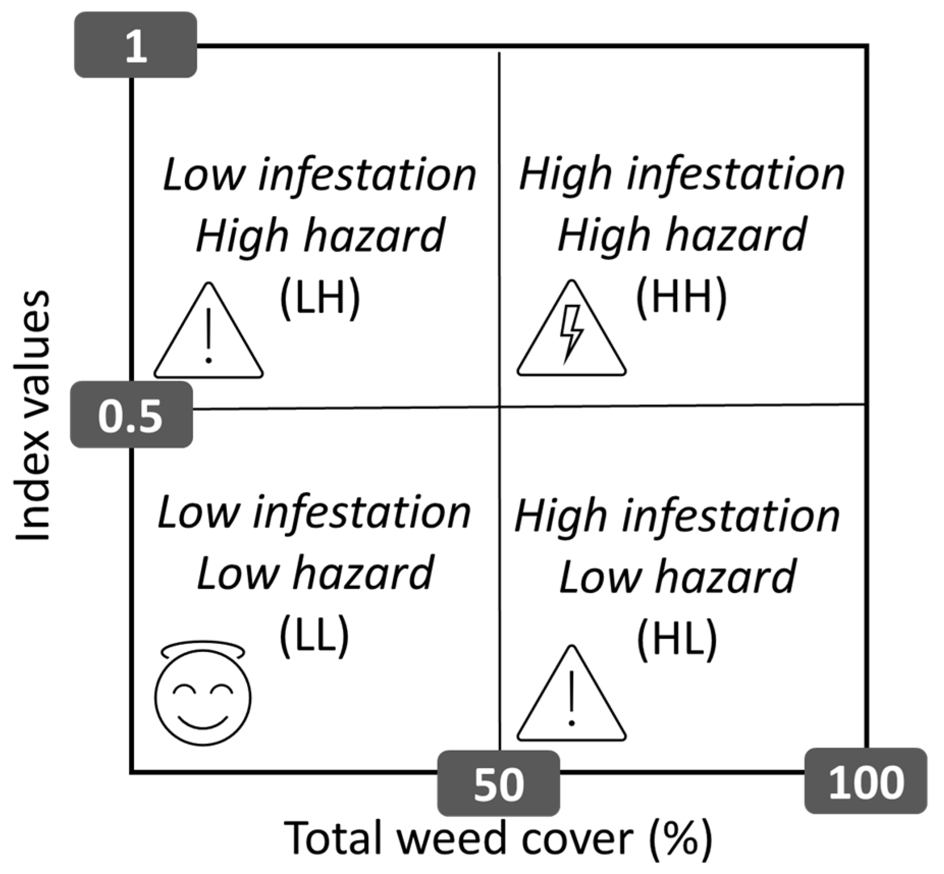
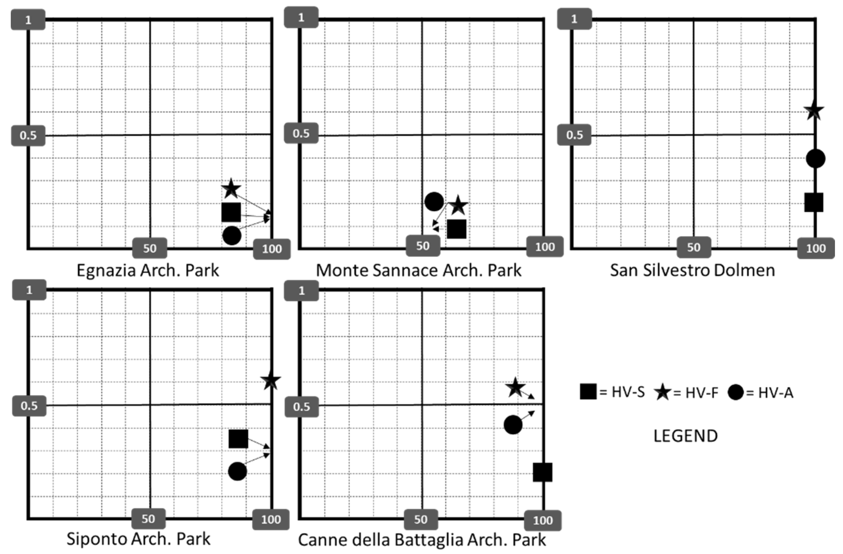
In order to show a possible way to use data and to provide an overall evaluation of the weed community impact, a diagram with 4 quadrants has been drawn that relates the total weed cover with its level of hazard, using the aggregate Indexes. In our study, we assumed as “not critical” a cover below 50% and an Index value below 0.5.
The possible meaning of each quadrant is described below (see also
Figure 4).
Quadrants with Low infestation and High hazard (LH) or High infestation and Low hazard (HL). They represent “conditions of attention”. In the first condition, although unwanted flora occurs, it has low levels of coverage; therefore, priority could be given to other sites for the execution of control operations. In the second case, although there is a high infestation, this does not present dangerous characteristics for the damages considered.
Quadrant with Low infestation and Low hazard (LL). It represents a “safe condition”, as there is a low infestation, and not even potentially harmful.
Quadrant with High infestation and High hazard. It represents a “condition of priority”, with high infestation and, in addition, potentially harmful. Sites in this condition must have priority in performing control operations.
3. Results
Considering the complexity of the surveys, in order to better explain the proposed procedure, only the results of the most homogeneous areas are shown and commented on. A complete list of the species found in each archaeological site is provided in
Table S2 with the information of the relevant Hazard Index (HaI).
With the exception of MSA, in all sites, coverage was greater than 100% (
Table 4). Weed flora was dominated mainly by Therophytes and Hemicryptophytes. The highest number of species (37) was found in SSI, while the lowest (23) in CAB. Although the number of species and the levels of infestation were quite different, the Shannon Index did not vary too much among sites (
Table 4).
Table 5 shows the Infestation Hazard Values calculated in each site. The Hazard Value on Structures (HV-S) did not differ too much among the sites, ranging from 0.1 (MSA) to 0.3 (SIP).
Concerning the general hazards (
Table 5), the highest risk of flammability indicated by the HV-F was calculated for the sites SSI and SIP (0.6), while the infestation in the sites EGN and MSA had low risk, with an Index of 0.2 and 0.1, respectively. As for the risk related to the presence of weeds with allergenic properties, the highest HV-A was found in the site CAB (0.5), followed by the site SSI (0.4).
Figure 5 allows comparing, at a glance, the weed impact on the sites. Although in all the sites the infestation was higher than 50 %, its Hazard Value differed according to the different aspects considered; it follows that icons indicating the Indexes are disposed of in different quadrants. Both in the Archaeological Park of Egnazia and Monte Sannace, all the Hazard Values were in the low hazard quadrant. At the San Silvestro Dolmen and Siponto Archaeological Park, HV-S and HV-A are in the low hazard quadrant, while HV-F is in the high hazard quadrant. As for the Canne della Battaglia Archaeological Park, HV-S is positioned in the low hazard quadrant, whereas the other two indexes are between the low and the high hazard quadrants.
4. Discussion
Although other indexes (e.g., that proposed by Signorini [
14]) offer a significant contribution to the quantification of the hazard for the structures related to each single species, they do not allow a broader assessment of the weed community impact on the site. Further years of observation of the same sites could lead to the definitive validation of the approach; however, even if developed in an initial stage, the present study expands the considerations about the danger due by weeds in sites of historical and cultural interest, which also concern their use and management.
It also shows that even the assignment of an index to each individual species would not be sufficient in the decision support for weed management planning. The abundance of infestation and its assortment are also necessary parameters to keep in consideration, as they are directly related to the magnitude of the impact. We proposed the use of aggregate indexes to obtain a synthetic evaluation that combines species traits, assortment, and abundance. All these aspects were taken into account within the proposed step-by-step procedure that, starting from the surveying of the species occurring on the site, results in an at-a-glance representation of the weed community impact.
A similar approach was used to evaluate the agronomic and ecological performance of the weed community in olive groves managed with various techniques [
23] or to evaluate the pastoral value of some grasslands, based on the palatability of the botanical species occurring in the sites [
24]. Even if conducted in areas with very different characteristics, these studies share a same assumption: the same cover of plants can generate different effects based on the traits and assortment of the single botanical species that compose it.
Each weed control technique can determine different effects on the floristic community [
25]; in case a same technique is continuously adopted, this selection pressure can eventually lead to a negative situation in which only some species difficult to control are present. In the procedure, the first evaluation of these possible effects was also proposed through the use of the Shannon index; together with the richness, it provides an indication of the simplification degree of the floristic community.
Specifically, the sites analyzed in this study showed a flora quite rich in species forming a very dense cover, being in the period of maximum vegetative expression and before the control operations. The Shannon Index calculated for each location is quite similar. This value can only be interpreted on the basis of multi-year data, which can highlight a shifting of the weed community. A decrease in value, with the same richness, could mean a shift towards a population in which only a few species dominate. Anyhow, just to give a rough indication of its synchronic/absolute meaning, we can refer to studies conducted in other areas. In particular, a study conducted in Apulian olive groves, i.e., in areas that are in any case disturbed, reported a mean value equal to 1.1 for chemically weeded orchards and a value equal to 1.9 for fields in which weeds were mowed [
26]. Furthermore, in other much less disturbed Apulian areas such as natural pastures [
24], average values ranged between 3.9 and 4.4. Based on the aforementioned literature, we can conclude that the flora structures in the sites that we studied seem in line with that of flora in a highly disturbed site, as expected.
Despite these common characteristics, the values of the Hazard Values revealed the presence of a flora that was variously assorted in terms of impact magnitude. The factors included in our proposed index were chosen according to the needs and characteristics of the visited areas. This does not exclude the possibility of identifying others that are closer to specific needs, although the evaluation procedure may remain the same. In addition, with regard to the choice of thresholds of the different dangerous situations, our work identifies the procedure rather than the values to be used in each situation. The choice must be made on the basis of specific considerations and needs concerning the archaeological site. The areas we visited were able to withstand an impact represented by the values we chose (0.5 and 50%); however, other areas may contain finds highly sensitive to the presence of weeds, and therefore, the thresholds must necessarily be lowered; the proposed procedure remains valid in any case.
From the data obtained, different suggestions could be drawn for planning management interventions. For example, although characterized by high abundance, the weed community in the Egnazia and Monte Sannace Archaeological Parks had low levels of hazard. It is therefore important to control the infestation avoiding techniques that exert selection pressure on less desirable species, such as those potentially harmful to structures (e.g., perennial species). For this purpose, the use of chemical herbicides should be limited, as they can exert selection on the weed community more easily than mechanical interventions [
27]. At the time of the survey, in addition to having a high level of infestation, the other sites were generally subject to a higher danger of fire. This is mainly due to the high abundance of species belonging to the Poaceae family. Given these conditions, chemical weeding would devitalize the vegetation, but it would not reduce the dry biomass which is easily inflammable. In this type of community, early chemical intervention is needed when coverage is lower; alternatively, it would be more convenient to mow the weeds. Concerning the occurring of allergenic plants (determined from the available literature, see
Table S2), in all sites, the index was different from 0; it follows that in all of them, there are potentially undesirable plants. It would be advisable to control the infestation before flowering, avoiding the release of pollen. The priority of the interventions must be given to the sites with the highest Hazard Index, such as San Silvestro Dolmen and Canne della Battaglia.
The study here presented and the procedures described can be considered an exercise and an example of how they can support decisions in managing the sites. Indeed, comparing hazard indexes with the total cover, weed infestation generates a different level of impact, depending on the type of interference considered. This confirms the importance of understanding the type of infestation, meant as the weed community, and not only its extent.
One question that remains to be explored is that our study considers all plants as “weeds”, thus potentially undesirable for site management and use. In historical sites, sometimes, also species or plant communities deserving conservation can be found. For example, this is the case of
Hieracium australe Fr. subsp.
australe on the walls of the Sforza Castle in Milan (Italy) where it is endemic [
28]. In our study, we propose a method to quantify the possible relationship between plants and historical heritage with the aim to make effective site management. Other considerations arising from a multidisciplinary approach would enrich the decision tools.


