A Legacy of Quantitative and Qualitative Data for the Irrigated Violada Area and Conterminous Lands in Aragon, Spain


Abstract
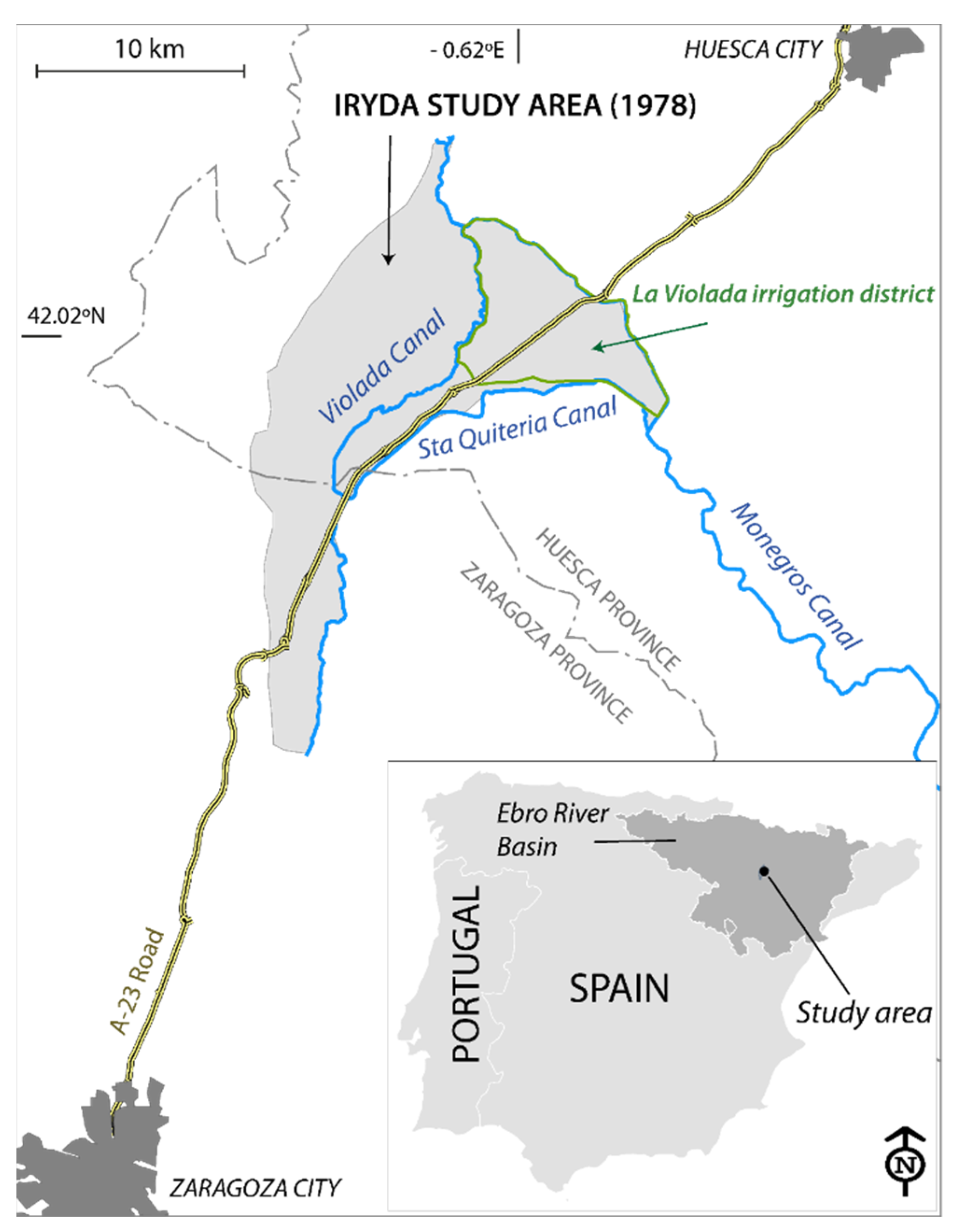
:1. Introduction
2. Temporal and Geographic Setting
3. Methods Used to Study Soil in 1978 and Resulting Information
- (a)
- Descriptions of 14 soil profiles and their classification according to the Soil Taxonomy System [17], as well as their suitability for irrigation according to USBR [18]. All the profiles were Xerochrepts, with five Calcixerollic, five Aquic, three Petrocalcic and one Typic. The classification of the profiles according to their irrigation suitability was: five Class 3sd, four Class1, three Class 3s and 2 Class 2s;
- (b)
- Laboratory determinations for four samples of irrigation water and five phreatic water samples: dry residue, electrical conductivity, pH and ions as well as derived indices. The average pH of the irrigation water was 7.95, compared to 7.45 for the phreatic water. The average SAR values were 0.5 and 2 for the irrigation water and phreatic water, respectively. Table 3 summarizes the salt content of the irrigation and phreatic waters;
- (c)
- Chemical analyses and particle size distributions for 50 soil samples from the 14 profiles and six auger holes. Calcium carbonate, with a mean content of 41.2%, was a prominent component of all the soils. This feature, together with the composition of the irrigation water (Table 3), prevented the sodification of the soils by irrigation.
4. Conclusions
Author Contributions
Funding
Acknowledgments
Conflicts of Interest
References
- IRYDA. Estudio de Los Suelos del Primer Tramo de la Zona Regable de Monegros I (Zaragoza-Huesca). Ministerio de Agricultura, Madrid, 46 Pages, 4 Annexes, 5 Planes. 1978. Available online: https://opacaraimagenes.aragon.es/69/61/AHPZ_A_040044_0007_01.pdf (accessed on 17 April 2021).
- Castañeda, C.; Herrero, J.; Latorre, B. The vanishing legacy of soil salinity data from irrigated districts: A case study from Spain and a call for action. Adv. Agron. 2020, 161, 325–355. [Google Scholar] [CrossRef]
- Nachshon, U. Soil degradation processes: It’s time to take our head out of the sand. Geosciences 2021, 11, 2. [Google Scholar] [CrossRef]
- Daliakopoulos, I.N.; Tsanis, I.K.; Koutroulis, A.; Kourgialas, N.N.; Varouchakis, A.E.; Karatzas, G.P.; Ritsema, J. The threat of soil salinity: A European scale review. Sci. Total Environ. 2016, 573, 727–739. [Google Scholar] [CrossRef] [PubMed]
- Ayers, A.D.; Vázquez, A.; de la Rubia, J.; Blasco, F.; Samplón, S. Saline and sodic soils of Spain. Soil Sci. 1960, 90, 133–138. [Google Scholar] [CrossRef]
- Cervera-Álvarez, R. Los suelos salinos de la Depresión del Ebro. Boletín de la Asoc. Nac. de Ing. Agrónomos 1966, 167, 193–199. [Google Scholar]
- Jordán de Urriés Azara, F.; de Haro Moreno, C.; Laguna Reñino, M. Dictamen Sobre Los Precios Máximos y Mínimos en Secano Aplicables a Las Clases de Tierra y Aprovechamientos de la Zona de La Violada; Dictamen Mecanografiado Elevado al Ministro de Agricultura, 1951; p. 39. Available online: http://hdl.handle.net/10261/169597 (accessed on 17 April 2021).
- De los Ríos Romero, F. El Riego por Aspersión en Los Nuevos Regadíos del Valle del Ebro; Condiciones Aconsejables Para su Instalación; Informe Mecanografiado; Ministerio de Agricultura, Instituto Nacional de Colonización: Zaragoza, España, 1967; p. 25. [Google Scholar]
- Serrano, J.; Bellot, F.; Golley, F. The role of natural vegetation in the biogeochemistry of an agricultural landscape. Acta Oecol. 1992, 13, 569–581. [Google Scholar]
- Isidoro, D.; Quílez, D.; Aragüés, R. Environmental impact of irrigation in La Violada District (Spain): I. Salt export patterns. J. Environ. Qual. 2006, 35, 766–775. [Google Scholar] [CrossRef] [PubMed]
- Barros, R.; Isidoro, D.; Aragüés, R. Three study decades on irrigation performance and salt concentrations and loads in the irrigation return flows of La Violada irrigation district. Agric. Ecosyst. Environ. 2012, 151, 44–52. [Google Scholar] [CrossRef] [Green Version]
- Herrero, J.; Castañeda, C. The success story of irrigation against salinity in Violada, NE Spain. Land Degrad. Dev. 2018, 29, 3039–3049. [Google Scholar] [CrossRef]
- Jiménez-Aguirre, M.T.; Isidoro, D. Hydrosaline balance in and nitrogen loads from an irrigation district before and after modernization. Agric. Water Manag. 2018, 208, 163–175. [Google Scholar] [CrossRef] [Green Version]
- Jiménez-Aguirre, M.T.; Isidoro, D.; Usón, A. Soil variability in La Violada Irrigation District (Spain): I Delineating soil units for irrigation. Geoderma 2018, 311, 78–90. [Google Scholar] [CrossRef] [Green Version]
- Jiménez-Aguirre, M.T.; Isidoro, D.; Usón, A. Soil variability in La Violada Irrigation District (Spain): II Characterizing hydrologic and salinity features. Geoderma 2018, 311, 67–77. [Google Scholar] [CrossRef]
- Mora, J.L.; Herrero, J.; Weindorf, D.C. Multivariate analysis of soil salination-desalination in a semi-arid irrigated district of Spain. Geoderma 2017, 291, 1–10. [Google Scholar] [CrossRef] [Green Version]
- Soil Survey Staff. Soil Taxonomy: A Basic System of Soil Classification for Making and Interpreting Soil Surveys; Agriculture Handbook; USDA: Washington, DC, USA, 1975; p. 436.
- USBR. United States Department of the Interior, Bureau of Reclamation Manual, Vol. V Irrigated Land Use. Part. 2 Land Classification; Estrada, A.J., Ed.; Ministerio de Obras Públicas de Venezuela: Caracas, Venezuela, 1963; p. 198.
- Sumner, M.E. Soil testing and plant analysis: Building a future on our legacy. Commun. Soil Sci. Plant Anal. 2006, 37, 2277–2287. [Google Scholar] [CrossRef]


| Field Tests | Number |
|---|---|
| Holes opened by hand auger | 97 |
| Pits opened by backhoe, with the soil profile described and sampled | 14 |
| Permeability tests by the auger hole method | 7 |
| Piezometers installed | 12 |
| Farmers’ surveys on farm economics and irrigation practices | 25 |
| Analyses Conducted at the IRYDA Laboratory in Madrid | |
| Soil samples | 50 |
| Phreatic water samples | 5 |
| Irrigation waters analyzed in 1975 | 4 |
| Kind of Data | Page |
|---|---|
| Expected maximum rainfall | 3 |
| Quality of irrigation water | 15 |
| Current crop yields | 17 |
| Soil units in each geomorphic unit | 18–24 |
| Soil characteristics: depth up to plant growth limiters, texture, surface stoniness, electrical conductivity (EC) of the phreatic and slope | 23b |
| Precipitation deficit | 25 |
| Leaching requirements | 27 |
| Irrigation requirements | 28 |
| Number of irrigations applied monthly to each crop | 29 |
| Soil characteristics affecting their potential under irrigation | 31b |
| Description of each land class; surface area of each class and subclass | 32–36 |
| EC | Cl− | HCO3− | SO42− | Ca2+ + Mg2+ | Na+ | K+ | Ca2+ | |
|---|---|---|---|---|---|---|---|---|
| Irrigation | 0.4 | 2.6 | 2.6 | 0.9 | 3.5 | 0.7 | 0.0 | 2.4 |
| Phreatic | 3.6 | 4.2 | 3.9 | 31.8 | 33.4 | 7.0 | 0.4 | 17.9 |
| Name, Scale | Main Information |
|---|---|
| 1. Location, 1:400,000 | Geographical location on an official topographic map. |
| 2. Current land use, 1:25,000 | Alternating rainfed cereal crop and fallow, irrigated herbaceous crops, irrigated fruit trees, pine trees, poplar trees, groves of the river banks, waterlogged areas. |
| 3. Geomorphology, 1:25,000 | Alluvial with coarse texture, alluvial with fine texture, alluvio-colluvial valley, recent terraces of the Gállego river with coarse, medium and fine texture or with colluvium, old terraces of the Gállego river, with petrocalcic horizon, dejection fans and colluviums, residual hills, erosion slopes, fine debris slopes, coarse debris slopes, main drainage network. |
| 4. Soils map, 1:25,000 | Texture: loam, sandy, clay, silty; stoniness; slopeRecommended crops; expected yield; soil depth to: marl or gypsum, phreatic water, petrocalcic horizon, gypsum accumulation, non-cemented gravel; electrical conductivity of the phreatic water. |
| 5. Land classes USBR, 1:25,000 | Irrigable lands; non-irrigable lands; land associations; limiting factors: soil, drainage, slope, only fruit trees, only sprinkling irrigation; recommended improvements: phreatic water control, salinity control, crack of the petrocalcic horizon, removal of stones; marked observation sites: augerings, analyzed augerings, augerings with permeability test, pits with soil analyses, plus permeability test and plus piezometer. |
Publisher’s Note: MDPI stays neutral with regard to jurisdictional claims in published maps and institutional affiliations. |
© 2021 by the authors. Licensee MDPI, Basel, Switzerland. This article is an open access article distributed under the terms and conditions of the Creative Commons Attribution (CC BY) license (https://creativecommons.org/licenses/by/4.0/).
Share and Cite
Herrero, J.; Castañeda, C. A Legacy of Quantitative and Qualitative Data for the Irrigated Violada Area and Conterminous Lands in Aragon, Spain. Agronomy 2021, 11, 799. https://doi.org/10.3390/agronomy11040799
Herrero J, Castañeda C. A Legacy of Quantitative and Qualitative Data for the Irrigated Violada Area and Conterminous Lands in Aragon, Spain. Agronomy. 2021; 11(4):799. https://doi.org/10.3390/agronomy11040799
Chicago/Turabian StyleHerrero, Juan, and Carmen Castañeda. 2021. "A Legacy of Quantitative and Qualitative Data for the Irrigated Violada Area and Conterminous Lands in Aragon, Spain" Agronomy 11, no. 4: 799. https://doi.org/10.3390/agronomy11040799