Review

Remotely Piloted Aircraft (RPA) in Agriculture: A Pursuit of Sustainability

1
Department of Plant Physiology, University of Granada, 18071 Granada, Spain
2
Department of Engineering Construction and Project Management, University of Granada, 18071 Granada, Spain
3
Department of Electronics, University of Granada, 18071 Granada, Spain
*
Author to whom correspondence should be addressed.
Agronomy 2021, 11(1), 7; https://doi.org/10.3390/agronomy11010007
Submission received: 24 November 2020 / Revised: 12 December 2020 / Accepted: 21 December 2020 / Published: 23 December 2020
(This article belongs to the Special Issue Remote Sensing in Agriculture)

Abstract

:
The current COVID-19 global pandemic has amplified the pressure on the agriculture sector, inciting the need for sustainable agriculture more than ever. Thus, in this review, a sustainable perspective of the use of remotely piloted aircraft (RPA) or drone technology in the agriculture sector is discussed. Similarly, the types of cameras (multispectral, thermal, and visible), sensors, software, and platforms frequently deployed for ensuring precision agriculture for crop monitoring, disease detection, or even yield estimation are briefly discoursed. In this regard, vegetation indices (VIs) embrace an imperative prominence as they provide vital information for crop monitoring and decision-making, thus a summary of most commonly used VIs is also furnished and serves as a guide while planning to collect specific crop data. Furthermore, the establishment of significant applications of RPAs in livestock, forestry, crop monitoring, disease surveillance, irrigation, soil analysis, fertilization, crop harvest, weed management, mechanical pollination, crop insurance and tree plantation are cited in the light of currently available literature in this domain. RPA technology efficiency, cost and limitations are also considered based on the previous studies that may help to devise policies, technology adoption, investment, and research activities in this sphere.

1. Introduction

The world is going through rapid technological shifts and innovations. The agriculture sector has also been benefiting from such technological advancements for many years. An indispensable way of accomplishing more by utilizing fewer resources and exerting little effort is considered as innovation [1]. It is very well argued that enriching raw material by innovation ensures production efficiency, contributes to economic growth, food safety and security [2].
In recent years, the use of technology in agriculture has gained momentum of which GIS (Geographic Information System), satellites, air vehicles, autonomous robots, GPS (Global Positioning System) and various other communication technologies have made their way into farming. With the innovation and implementation of such technologies, new terms like “precision agriculture”, “precision farming”, “precision approach”, “digital farming” and “agriculture 4.0” etc. have appeared on the horizon. The precision agriculture is defined as information and technology based agricultural production system that is used in order to analyze, determine, and manage field factors like spatial and temporal variability for obtaining maximum sustainability, profit, and environmental protection [3].
Precision agriculture that paves the way to make efficient plans for pest control, harvest, irrigation, disease control, and optimum fertilization etc. is an emerging technology and is related to the development of technology for obtaining and analysing data that in turn results in the implementation of adequate solutions [3,4]. Remote sensing (a technique of collecting information about objects without establishing any physical contact with them [5]) has proven itself an integral part of precision farming. Although, it was initially linked to photogrammetry with the usage of balloons for aerial observation as first ever aerial photographs captured thus date backs to 1858 aboard a hot-air balloon [6]. Various platforms are used for remote sensing and can be classified as aerial platforms (i.e., planes, helicopters, drones, balloons) and spatial platforms (i.e., satellites) that use sensors for measuring reflected or emitted electromagnetic radiations from the object under study. Consequently, they can be classified according to the radiations they register into passive (cameras, scanners, etc.) and active (radar and LIDAR) ones. The formers are limited to collecting the electromagnetic energy reflected or emitted by the surface, while the latter discharge radiations towards the observed surface and collect the energy reflected by it. A refined definition for remote sensing according to the scope of this article could thus be: a set of techniques that analyse the data obtained by sensors on aerial or spacial platforms, including the acquisition of data from earth’s surface as emitted or reflected radiations followed by its subsequent reception, correction and distribution, as well as its final treatment by experts for the extraction of useful information in which the end user can support their decision-making.
Satellites and drones are the most commonly used tools in precision farming. With the launch of Landsat-1 satellite in 1972 [7], a new era of remote sensing began. Nevertheless, given the recent technological advancements, the use of drones has become widespread and is gaining popularity due to the number of benefits they offer, explicitly integrated sensors and imagery system [2,8]. Remotely Piloted Aircraft (RPA), commonly known as drone, refers to a remotely controlled or autonomously flown, unpiloted, unmanned aircraft that is based on complex dynamic automation systems [3]. The incorporation of drones into precision farming is a growing agricultural trend with a potential of invoking novel agricultural and economical trails. Although, today’s research is slanted towards the employment of novel tools and sensors capable of remote surveillance of soil properties and crops in quasi-real-time [3].
To ensure global food security for the cumulating world population, there is an immense need for closing the gap between actual and potential crop yields. The most prominent factors contributing to this gap include interactions among the crop genotype, environment, and management: G × E × M [9]. For instance, a difference in soil affects fertilizer uptake even if the crop response to fertilizer application is known, thereby contributing to this yield gap. Similarly, on practical basis farmers usually apply excessive fertilizers than the desired amount, even for areas of high potential yield, resulting this excessive fertilizer to be accumulated in the ground and deteriorating water quality [10,11]. International controls on the use of fertilizers in agriculture not only ensure the safety of humans but also the environment. That’s why it is very important not to exceed these limits by over-fertilizing the land. For improved crop yield, as nitrogen (N) is the most limiting crop nutrient, so N based fertilizers are applied frequently [12]. However, this also augments the N losses to the environment via leaching or gaseous emissions. For example, fertilizer nitrate (NO3) leaching pollutes the surface and ground water [13]. Ultimately, these NO3 ends up in our diet. In human body NO3 is converted to NO2 and then eventually to nitrosamine compounds and NO in acidic environment (specifically in stomach). These compounds are responsible for methemoglobinemia that further provokes cancers, diabetes and thyroid disorders [14]. To nip the evil in the bud precision agriculture is the answer. Precision agriculture presents on site-specific information with optimized solutions for which drones are anticipated to play a key role thereby minimizing the yield gaps while widening up the room for scientific exploration and development [15]. RPAs are facilitating us in this domain too by furnishing the estimates of total N concentration in water, so that only the required amount of N fertilizer be applied avoiding the potential harmful impacts and saving the economic loss to farmers. One such practical example of using drone equipped with hyperspectral cameras to assess the N concentration in water has recently been reported [13]. Although the lower adoption rates of precision technologies than expected comprise of various factors including economical ones [15,16].
An overview of RPA technology with a prospective of sustainable agriculture is conveyed in this article. The current technology available for precision agricultural is discoursed along with examples. The promising feature of RPA technology with practical cases from the available literature and future perspectives are highlighted in this study. This study may help in better adoption of RPA technology, development of policy regulations, identifying the future research areas, and hinting towards the need for advancement of this mature technology given the challenging circumstances provoked by COVID-19 pandemic.

2. Remotely Piloted Aircraft (RPA)

Remotely Piloted Aircraft (RPA) or Unmanned Aerial Vehicle (UAV) refer to auto-piloted multipurpose aircraft. Although, the term UAV is considered obsolete because of the use of this term by aviation organizations and the operational complexity that they represent [17]. Whereas, the term RPA is acceptably used in Europe [18]. Other terminologies frequently used for referring to drones include: Dynamic Remotely Operated Navigation Equipment (DRONE), Remotely Piloted Vehicles (RPV), Remotely Piloted Aircraft Systems (RPAS), Remotely Operated Aircraft (ROA), and Unmanned Aircraft Systems (UAS) [17].
In 1930, RPAs or drones were known as “Queen Bees” [19] and were initially used by military followed by their disposition for civil use [20]. One of the earliest recorded use of RPAs was by the Austrians in July 1849, after around two hundred bomb-mounted, unmanned hot air balloons were launched in the city of Venice [21]. In agricultural context, use of RPAs for Montana’s forest fires monitoring was tested in 1986, followed by the documentation of enhanced image resolution captured using RPA named “Predator” in 1994 [20]. The first RPA model “Yamaha RMAX”, for pest control and crop monitoring applications, was developed by Yamaha [22]. By the year 2020, given the current uses of drones from hobbyists to industrialists, their market is anticipated to reach upto $200 billion [23]. Although, the pandemic caused by COVID-19 can certainly affect these estimates.
Currently, RPAs are gaining popularity as an integral part of precision agriculture and ensuring agricultural sustainability [24]. The agriculture sector is in demand of RPAs with diverse features to ensure better crop yields and for overcoming several challenges of farmers [23]. In forestry and agriculture, RPAs are increasingly becoming part of remote sensing and imaging applications with simultaneous analysis of data through mapping spatial variability in the field thereby paving the way for improved farm productivity [25]. For example, a quad-copter is reported to conduct crop scouting, map field tile drainage and monitor fertilizer trials [26]. Furthermore, the use of RPAs for biophysical variables’ (i.e., chlorophyll and biomass determination) control is also of particular interest [25].
The number of advantages of RPAs that they endow is the reason for their increasing demand in agriculture sector. The accessibility, flexibility and efficiency are their promising features. For example, RPAs are the cheapest means of land monitoring with high resolution images (up to 0.2 m) providing complete spatial coverage without worrying about the clouds interference compared to satellites and traditional aerial photography systems [4]. Similarly, the 3-D maps for soil and field analysis help farmers for their irrigation and nitrogen level management for better yield [23]. RPAs offer a prominent advantage over other aerial imagery means i.e., satellites and airplanes. The images taken by an RPA are 44 times better than satellite images and in terms of resolution, RPA camera offers over 40,000 times better resolution. Satellites and planes can equally suffer to bad weather and clouds. Furthermore, RPAs offer the freedom of flight scheduling and the flexibility to re-fly as per needs [27]. Additionally, low costs, agility, manoeuvrability, real-time data hunting for better yields, time saving by tremendously reducing inspection times, use of geographic information system (GIS) mapping for input cost management, high resolution imagery to overcome the pixel demixing problem, yield increase and resource management, the use of Infrared, normalized difference vegetation index (NVDI), and multispectral sensors for monitoring the crop health are few of the salient features of RPAs that make their use in agriculture attractive and sustainable [3,19,23].

2.1. Classification of RPAs

There are various RPAs in the commercial market to date including for military use but based on the use of RPAs in agriculture, they are largely categorized into rotary wing and fixed wing RPAs, Figure 1. Although both of these kinds have their own benefits and limitations. For example, structurally simple fixed wing RPAs lack hovering and require a runway for take-off and landing while offering high-speed flights for longer durations. Whereas, with structurally complex rotary wings RPAs exhibit low-speed flights for shorter duration, they are also capable of hovering, vertical takeoff, and landing with nimble maneuverability [22].
By the type of control, Pino [21] has classified the RPAs as:
(a)
Autonomous: An autonomous RPA doesn’t need a human pilot to control it from the ground. It is guided by its own integrated sensors and systems.
(b)
Monitored: In this case, a human technician is needed. The job of this person is to provide information and control the feedback of the RPA. The drone directs its own flight plan and the technician can decide what action to take. This system is common in precision agriculture and photogrammetry work.
(c)
Supervised: It is piloted by an operator, although it can perform some tasks autonomously.
(d)
Preprogrammed: It follows a previously designed flight plan and there is no way to modify it to accommodate possible changes.
(e)
Remotely controlled (R/C): It is piloted directly by a technician through a console.
However, Vroegindeweij, et al. [19] have categorized drones in the following types;
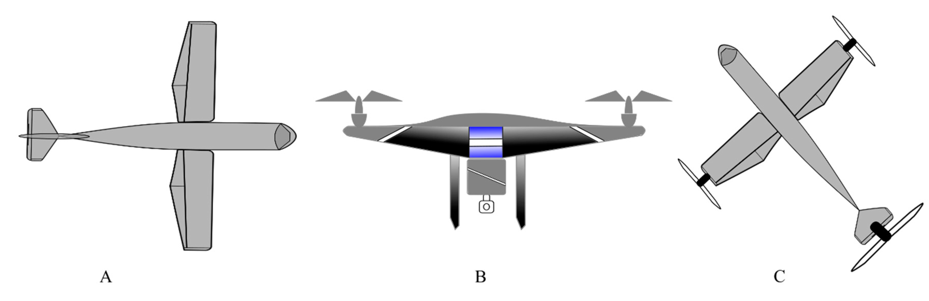
  • Fixed wings and flying wings RPAs (having limited maneuverability) that use a jet engine for thrust and wings for lift, Figure 1A.
  • Vertical take-off and landing (VTOL) RPAs (being very maneuverable) that use a rotor system for thrust and lift.
  • Micro RPAs, as their name indicate of very small sizes i.e., in the range of centimeters. They may use either rotors or flapping wings for thrust and lift.
  • Airships and parafoils (having lower maneuverability) that use balloons or parachutes for the flight.
  • Novel concepts and combinations that could be based on the previous principles to obtain the desired benefits, Figure 1C.
There is also a notable difference in the landing gears of fixed wings and rotary wings RPAs as the former ones may use wheels or magnetic levitation while the later ones have simple supporting structures. The rotary winged RPAs can further be of a helicopter, quadcopter, hexacopter, and octocopter, based on the number of rotors they have. The rotor movements are responsible for the lift of these copters as two of the four rotors, in a quadcopter specifically, move in clockwise direction and other two in the anticlockwise direction. Two configuration models plus (+) and cross (X) are used in quadcopters, of which the latter is more stable and common than former [22] (Figure 2).

2.2. Basic Architecture of an Agricultural RPA
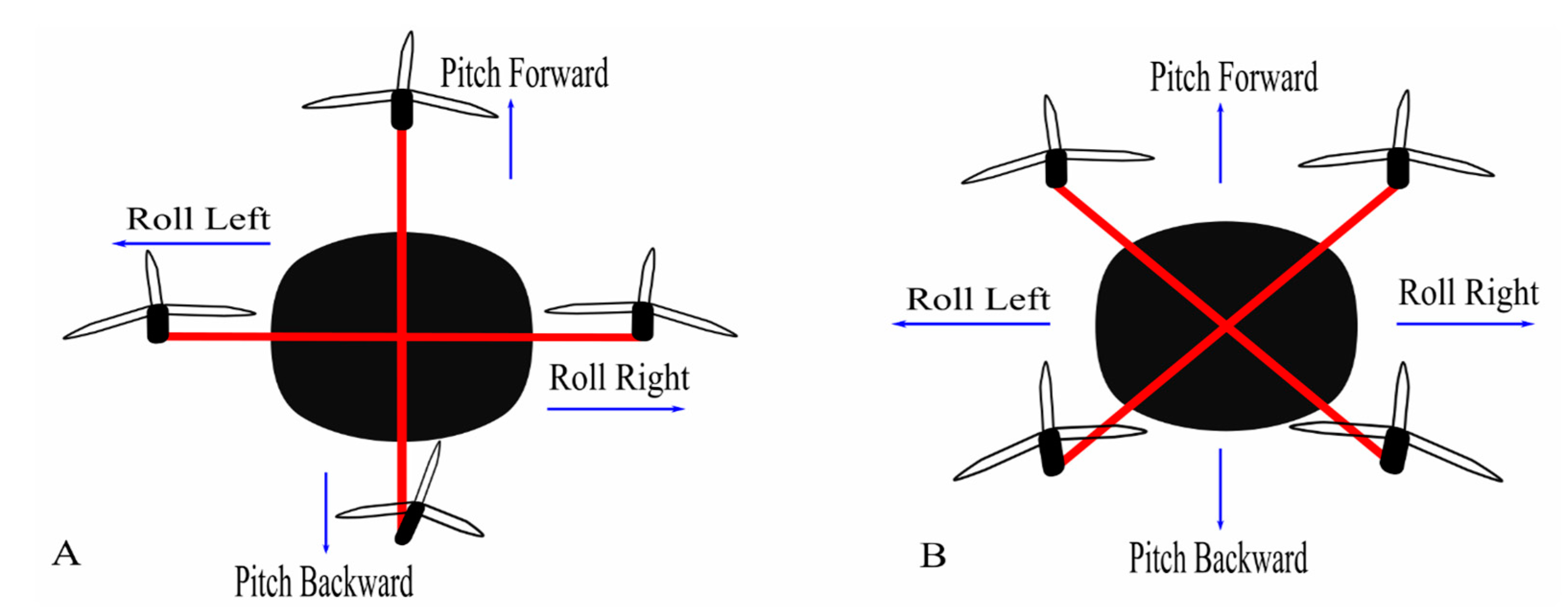
Usually following are the basic components of a RPA aimed for agricultural use [28].
  • Frame
  • Brush-less motors
  • Electronic Speed Control (ESC) modules
  • A control board
  • An Inertial Navigation System (INS) and Global Navigation Satellite System (GNSS)
  • Payload sensors (i.e., Light Detection and Ranging LiDAR systems, thermal camera, multispectral camera, RGB camera etc.) and altimeter (i.e., ultrasonic sensor, laser altimeter, barometer etc.)
  • Transmitter and receiver modules
All of these components are necessary not only for a steady flight but also for field monitoring and collecting various field data. The parameters like the normalized difference vegetation index (NDVI), leaf water content, ground cover, leaf area index (LAI) and chlorophyll content are quantified using multispectral cameras embedded on drones [28]. For example, a drone embedded with a thermal camera (thermovision A40M) and multispectral sensor (MCA-6 Tetracam) is a practical system for vegetation monitoring [29].
Similarly, the Digital Surface Model (DSM) or the Digital Terrain Model (DTM): digitization of the terrain surface of the monitored area is obtained using the components like LiDAR systems and RGB cameras. One such example of the enactment of these tools is previously reported [30,31].
Software programs intended for data processing and image analysis are not usually considered as a physical component of a drone but they play a crucial role in management, decision making and planning [32]. Various software, open-source solutions as well as marketable, are commercially available developed on the vendors’ policies. Some key features that such software programs should have include: data collection (imageries and videos assembly from drone and their storage in database), analysis and reports (production of valuable information after analysing the data like yield prediction etc.), map generation (creating 3D field models and high resolution maps), and flight planning and automation (real-time flight planning, scheduling and route optimization within the program) [32].

2.3. Choosing an Appropriate Drone

Given the market range, numerous drones with various features are available. As mentioned earlier, the simplest of the drone comes with a digital camera (e.g., Canon or GoPro) along with different filters. Although the choice of an appropriate drone for a farmer depends upon many factors. For example, an orchard growing farmer is more interested in the crop status than weed pressure while for a cash crop farmer it’s the opposite case [27].
With the intention of using a drone for PA, it should be capable of flying according to waypoints definition, of controlling its flight altitude, of landing automatically given the battery status, of sensing and avoiding the obstacles during its flight and of acquiring stabilized images. The Parrot Bluegrass has been reported to fulfil such requirements and is anticipated to be employed for PA practices [28]. A few of the commercially available drones for agricultural use are summarized in the Table 1.
Similarly, one is not restricted to solely rely on the commercially built drone packages (RPAs with cameras). RPAs can be modified as per needs by customizing the required cameras needed. For example, at various crop’s stages a farmer can be interested in different crop data (like crop’s irrigation need or crop health status) for which a thermal, multispectral, hyperspectral etc. camera might be required. Thus, a customized desired camera can be mounted on RPA. Most commonly used RPA cameras, as reported previously [6], with their fundamental characteristics are quoted in Table 2.

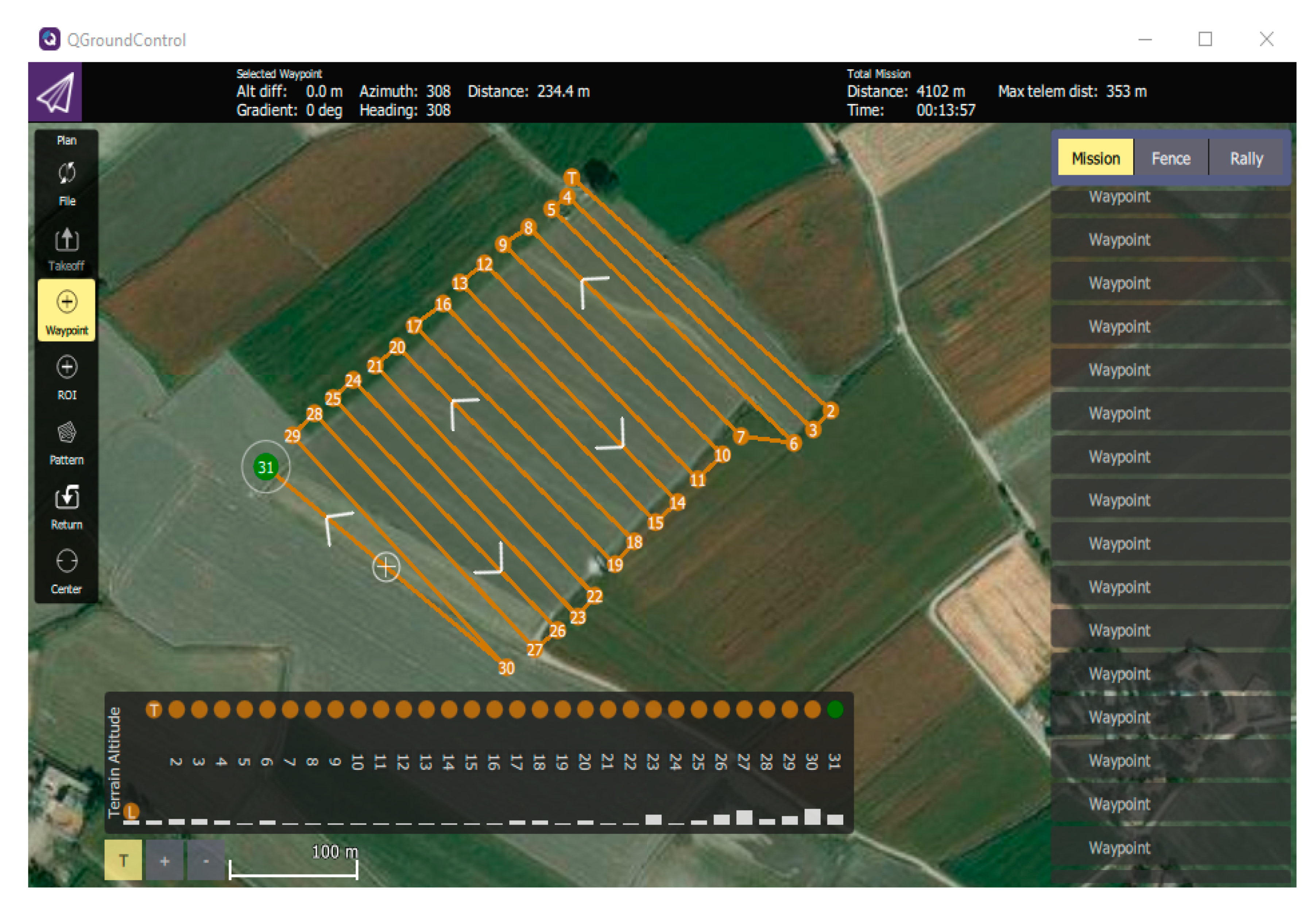
2.4. Flight Planning and Data Collection

Flight planning is an important and preliminary step for quality data acquisition. There are various ways to accomplish this. For example, software can be used to design and send the designed flight plan to the drone that is known as downlinking [17]. Similarly, applications can also be used on smartphones and tablets, for this purpose, facilitating the mission planning even minutes before the flight. These applications and software act as ground control station (GCS) for drones. Generally, the compatible software and application, to plan and execute missions, comes with the drone by the respective company. For example, in a study corresponding applications eMotion 2, the Mission Planner and DJI-Phantom were utilized for eBee, X8 and Phantom 2 drones [17]. On the other hand, there are plenty of free and open-source GCS available on the internet and one can choose according to his needs. A software interface of QGroundControl, an open source, and MAVLink enabled software, installed on windows, can be seen in Figure 3.
The other important factors for flight planning include estimation of flight area and surroundings, identification of potential hazards, preparation and configuration of equipment and weather conditions. The weather condition, as wind speed, can highly influence the drone flight. Similarly, presence of poles, trees, windmills, nearby roads, vehicles and populated areas are also considered before flying drones. Another important thing is to comply with the local and national laws regulating the drones’ flight.
Generally, to ensure the accuracy and quality of the data, image overlapping is performed. Although, few software do not facilitate the lateral and forward overlap. In this context, a study indorsed the greater overlap (lateral 50% and forward 80%) for orthomosaic preparation [17]. Nevertheless, higher overlays increase the image capturing time that further result in higher amounts of point cloud and therefore extended processing time. Siebert and Teizer [33] recommended at least 70 and 40% longitudinal and transverse coverage areas respectively. Anyhow, the need for a greater amount of overlap should be evaluated depending upon the respective drone used and its application. The flight plan, once completed, should be saved and by connecting a tablet or phone with the drone´s remote control, the desired mission can be executed.

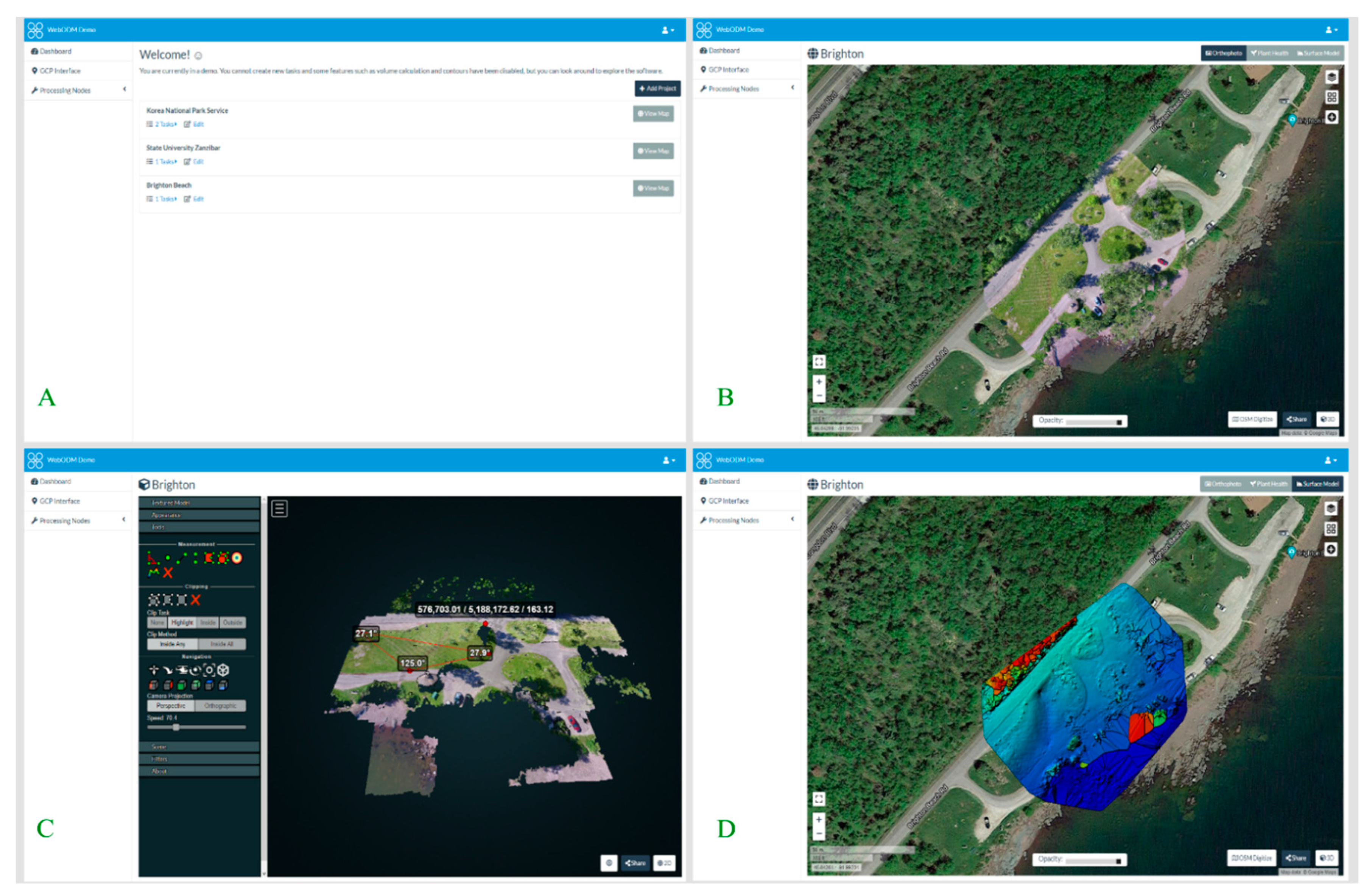
2.5. Image Processing and Software

Various open source and commercial software are in the market for pre-processing of images and automatic assembly of the orthomosaic and even facilitate a person with no prior expertise to extract meaningful information, in a shorter time as compared to conventional photogrammetry, of Digital Elevation Model (DEM), orthomosaic and DSM [17]. For example, Open Drone Map (ODM) is an open-source image processing software that allows to create and visualize orthomosaic, 3D models, point clouds, DEM, and other products (Figure 4).
According to a study the estimated time frame for flight plan and image acquisition, collecting GCPs, and photogrammetric processing are 25%, 15% and 60% respectively. This indicates the dire need of better, speedy and automatic software especially for processing tasks [6].
A semi-automatic workflow is used to process images acquired through drones. During this camera calibration, images alignment, cloud points generation is done ultimately producing the DEM and Digital Surface Model (DSM). These models are then used for 3D modelling, acquisition of metric information (i.e., heights, area calculation, volume etc.) and orthomosaics [17].
Supervised classification techniques can be applied on the obtained data to analyze the image and extract information e.g., soil use classification through object-oriented image analysis or by examination of the spectral bands of images [35,36]. Such studies of map generation using vegetation indexes have been reported [37,38].
Drones get an enhanced spatial resolution at low altitudes but remain unable to cover large extensions as orbital platforms. That’s why a large number of high-resolution images are recommended to cover larger fields. This extensive data to generate mosaic image of the field needs to be pre-processed. Interestingly, an automated method for the mosaic preparation was developed, to reduce the cumbersome and lengthy processing time, that implements the pre-processing of these images [17]. An overview of processed images of olive crop using multispectral camera (parrot sequoia) and thermal sensor mounted on Yuneec Typhoon H hexacopter drone, flown at a height of 40 m and 80 m respectively, are represented in Figure 5. Mission planner was used for flight planning followed by orthomosaic generation using Pix4D software and ultimately using QGIS for generating NDVI (image B), NDRE (image C), and thermal map (image D).
For various field operations (i.e., planting, spraying, nutrient application etc.) geo-referencing is used. A method of automatic geo-referencing, with 0.90 m accuracy, has been reported [11]. Since this margin of 0.90 m can prompt errors, hence further studies are suggested in this regard. Similarly, ground control points (GCPs), that are the representative points of the terrain like corners of a building and road crossings etc., pertain an indispensable importance with regard to enhancing maps accuracy and geometric correction of data acquired by the virtue of remote sensing. Use of global positioning system (GPS) receiver of Post-Processed Kinematic (PPK) or Real Time Kinematic (RTK) is recommended for taking coordinates. Using minimum GCPs for drones favors good results. As for example, a position error around ±0.20 m vertically and ±0.05 m horizontally was reported for 30 × 50 m area, when 24 GCPs were set with dual-frequency GPS RTK [39]. Similarly, when 23 GCPs were set with dual-frequency GPS RTK in another study for an area of 125 × 60 m, around 0.03–0.04 m vertically, and 0.04–0.05 m horizontally root mean square values for error were reported [40].

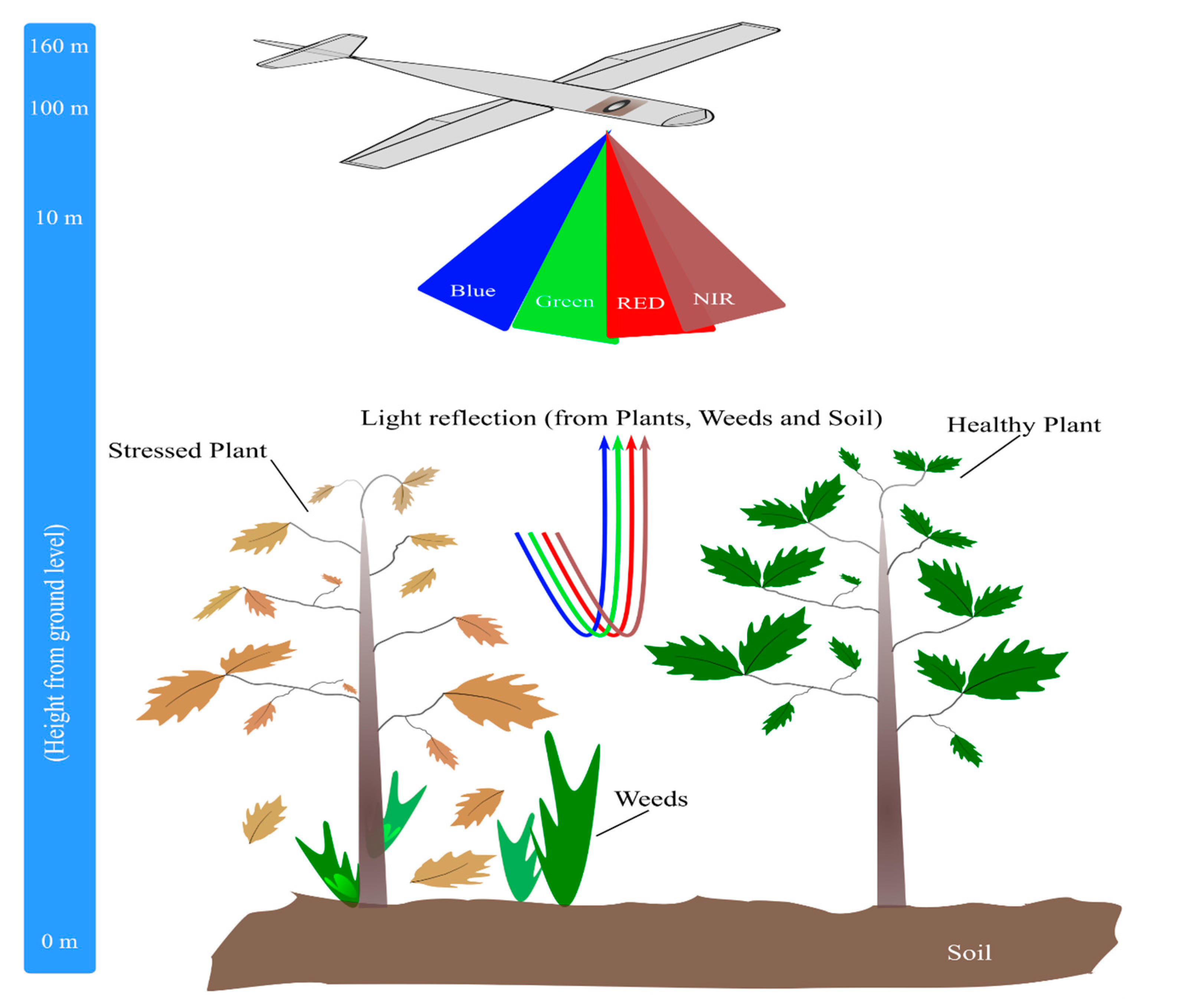
3. Implementation of Drone Technology in Agriculture

An increase in the application of drones in agriculture has been witnessed in recent times along with the development of novel strategies and modules for data acquisition and analysis. For example, a new Pulse Width Modulation (PWM) controller for RPA along with a software was developed by [41]. A wireless telemetry system was used to control commands of PWM controller between the ground control station and the RPA helicopter. LabVIEW 8.2 was used to test and validate the PWM controller and after several analyses, the researchers claimed a higher precision and efficiency in spray application of pesticide. Similarly, for total biomass and yield estimation of rice, an unmanned helicopter was used based on low-altitude remote sensing (LARS) platform [42]. The LARS platform was reported as a promising substitute for airborne remote sensing and satellite-based methods to estimate the rice crop biomass and yield as a function of its nutrient status. In this, they used a radio-controlled helicopter with a multispectral camera for image acquisition at a height of 20 m. Additionally, another RPA based on the octocopter platform was developed for Precision Viticulture (PV) capturing visible, multispectral and thermal imagery [43]. The visible imagery captured by a DSLR camera (Canon 550D) was processed to create Digital Surface Models (DSMs) using photogrammetric software. A Tetracam mini-MCA multispectral camera was also mounted on the same camera mount and vegetation indices were calculated based on the vegetation reflectance in critical wavelengths. They also attached a FLIR Thermal Infrared (TIR) camera to this mount for surface temperature measurements. Although the selection of cameras to be used in RPAs should be made keeping in mind its dynamic range that measures the shot noise (randomness of the photons acquisition) and the temporal dark noise (error in the discretization of the light in a pixel), and its signal to noise ratio (SNR) [25].
Furthermore, in another study the use of RPA for monitoring experimental plots by using a remote-controlled RPA and its additional advantage of lower costs in maintenance, operation and acquisition of aerial images was reported [44]. Likewise, scientists have also reported a remote sensing platform that works totally in an autonomous manner [45]. This study opened further doors for research and practical applications of drones in agriculture as the study was reported to assess the stress, irrigation and fertilization status of plants in real time using computational routines. Similarly, various research projects were undertaken after few initial reports on the use of RPA to investigate the data acquisition platforms and sensors in order to improve the technology for ensuring precision and sustainability in agriculture field. In 2013, a new Fabry Perot interferometer (FPI) based spectral camera was evaluated to be used in an RPA [46]. Researchers presented the assessment chain of this FPI spectral camera for DSM extraction, supervised biomass estimation, spectral data cube generation, radiometric correction and image orientation.
In the same way, to obtain the multispectral photographs of pasture enclosures, a Tetracam MCA (Multispectral Camera Array) and a consumer grade Canon PowerShot digital camera were used on a hexacopter and a quadcopter—two remotely controlled platforms, and were reported to be efficient in generating high quality (multispectral) image data which lead to better assessment of biomass and pasture quality cover [47]. Correspondingly, another study presented the configuration and specifications of an RPA (fitted with a six-band multispectral camera, two different sensors and a still visible camera) for remote sensing, for Early Season Site Specific Weed Management (ESSWM) [48]. Owing to the low flight altitude and flexibility, the RPA was shown to be capable of operating on demand according to the flight mission planned and capture ultra-high spatial resolution photographs. Currently, most of the applications of RPAs in agriculture are focused on maps generation for monitoring of crop stress, yield prediction, biomass estimation, weed infestations, and coverage. For example, execution of hyperspectral imagery for quantifying the chlorophyll per unit area, which directs towards plant’s photosynthetic capacity [25]. In a similar fashion, barley and wheat crops’ exhibit different vegetation densities based on the amount of fertilizer and seeds hinting towards the corresponding growth stage and health of crop [25].
Depending upon the purpose, sensors are selected for crop monitoring whereas; the most commonly used sensors in RPAs detect the following electromagnetic waves’ bands [24]:
(a)
Thermal Infra-Red band
(b)
Red, Green, and Blue (RGB) bands
(c)
Near Infra-Red (NIR) band
(d)
Red Edge band (RE)
Where, (a) is used for the yield forecasting, analyzing plant physiology and irrigation scheduling. (b) are implied for visual inspection of the crop field, modeling elevation and counting the number of plants. (c) is aimed at the assessment of crop health, water management, soil moisture analysis, plant counting and erosion analysis. (d) is used for crop health assessment, water management and plant counting purposes [24]. These are few commonly associated studies with regard to the bands of electromagnetic waves, although the use of these sensors is not limited to these bands and holds enormous prospect for further investigation.

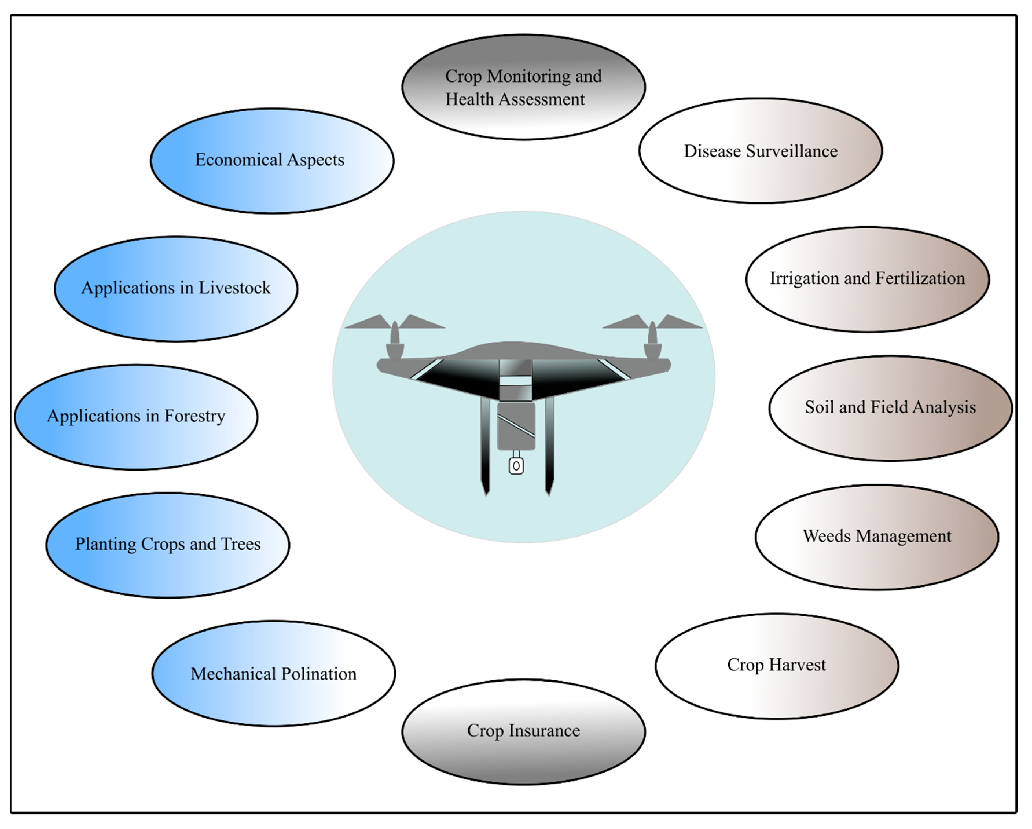
4. Applications of Drones in Farming

With the developing technologies and invention of novel sensors, drones are finding numerous application in agriculture field. The ease and autonomy that RPAs offer is their prominent feature. For example, they can either be flown manually or put on GPS programmed pre-determined paths where learning to pilot is not more than a few hours job with the possibility of one touch takeoff and ground steering. Self-leveling programs further facilitate their autonomy by helping in the acquisition of stabilized images while adjusting the drones to the wind [27]. Few of their most common applications along with novel areas of application are discussed below.

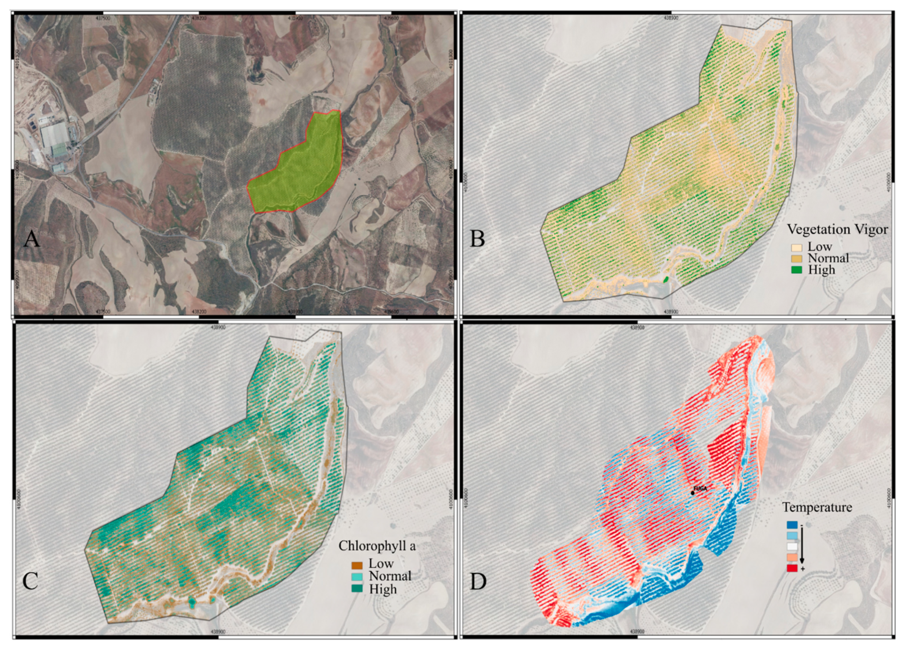
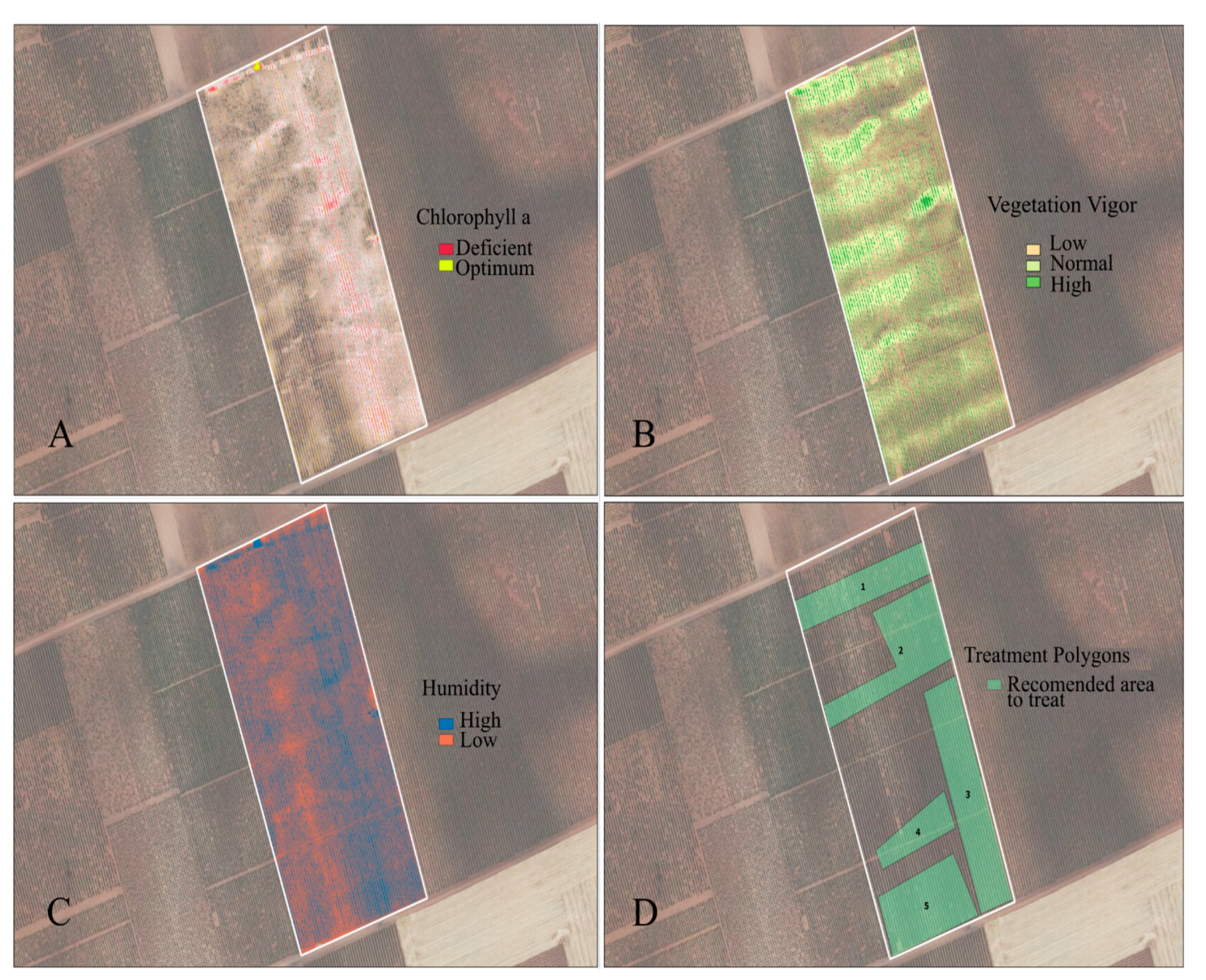
4.1. Crop Monitoring and Health Assessment

RPAs have been anticipated for counting plants, monitoring growth, phenology and chlorophyll measurement among other potential applications [21]. For this purpose, RPAs like SenseFly’s eBee Ag, having NDVI or near infrared (NIR) sensors, have replaced the conventional farm scouting by significantly minimizing the human error [49]. RPAs are also highly efficient sources of monitoring crops especially in hilly areas that are otherwise challenging for conventional scouting [24]. The most commonly used vegetation indices for crop monitoring and health assessment are summarized in Table 3.
Several vegetation indexes, for example NDVI, are in play to assess the disease, water deficiency or nutrient stress in crops and present useful information like even the presence of algae etc. [15]. Psirofonia, et al. [75] have also reported an effective way of pest or disease infestation detection and mapping in olive and palm plantations, using RPAs. Moreover, the use of drones in the early detection of disease or deficiency in crops has also been suggested to timely mitigate the stress [24].
Recently, Parrot RPA is proposed for effective crop assessment in terms of determination of the density of green on a patch of land. The RPA camera uses the light reflectance from plant (i.e., chlorophyll and leaves) for the determination of their spatial distribution. Following is proposed for calculating NDVI [25]:
N D V I = N I R R E D N I R + R E D
where, the spectral reflectance measurements acquired in near-infrared and red regions are indicated by NIR and RED respectively. Higher the value of NDVI, the denser and healthier will be the vegetation. Whereas the range of NDVI varies from −1 to +1. Although, different cameras provide different NDVI values for the same field and time of flight, which could mislead the user. Agricultural cameras, however, can provide a standard NDVI that is comparable to other agricultural cameras such as those on satellites. An illustration for a drone equipped with NIR and other sensors for taking data from soil, plant and weeds is presented in Figure 6.
The data collected by crop monitoring, if integrated with soil fertility and weather forecast data, can predict harvest time and yield of crop that in turn can be a vital source for bureaucrats and farmers to accordingly plan for storage and marketing [24].

4.1.1. Variable-Rate Fertility

For refining variable-rate applications (VRA) like Potassium, Phosphorus and Nitrogen, satellite or ground-based images are considered more useful although RPAs do have their uses. For example, drone generated VRA maps are reported to be useful for in-season fertilizer applications on corn and other crops thereby adding up for increased yield [49]. Similarly, novel VIs are being investigated for remote detection of macronutrients. For example, hyperspectral remote sensing was used to monitor N, P and S in Oryza sativa L. reporting novel spectral algorithms especially for P (P_670_1092 and P_670_1260) and S (S_670_1090), as the previously reported VIs did not entail better accuracy for them [76]. Such advancements are really productive in precision agriculture favoring accuracy in real time monitoring. Figure 7 represents the practical example of the data taken for a field of olive plants, using multispectral camera (Parrot Sequoia) mounted on Yuneec Typhoon H hexacopter drone flown on a height of 40 m, and the recommended areas of treatment depending upon the generated maps.

4.1.2. Disease Surveillance

There is a possibility that crop withering and destroying pathogens evade detection due to the lack of careful inspection. Here comes the role of drones as they can easily distinguish the yellowing plants from the green ones [77]. In a study where drone was used to monitor the canola crop, the mapped region was reported to exhibit reductions in NDVI and leaf area index (LAI) hinting towards its inspection for nutrient deficiency, so that the subsequent pest and disease can be detected beforehand [17].

4.1.3. Airborne Pathogens Surveillance

Another captivating use of drones is monitoring airborne pathogens (e.g., Phytophthora or Fusarium). For this purpose, spore samples are collected using drones that later are grown in the laboratory and analyzed by the researchers. Virginia Tech University is undertaking this novel project [27].

4.1.4. Bird Pest Surveillance

An interesting use of drones is their potential in bird control strategies that is significant problem in agricultural community. Here too, drones have been demonstrated as an effective remedy to psychologically fight off the bird pests in vineyard, where ravens, silvereyes, and cockatoos were kept off [78].

4.2. Irrigation and Fertilization

RPAs are also serving to save water in agriculture. For substantial growers having various outstretched fields, management of multiple irrigation pivots is a quite a challenge. For example, in case of sorghum or jowar crops when they acquire certain heights, the watering system (the nozzles and sprinklers) observation becomes a critical task. Therefore, the use of RPA technology comes in handy for such situations by providing useful information for precise application of water quantities in the required area. For example, studies on apple crop with half of the field irrigated and the rest under water stress, resulted in establishment of substantial correlation between drone thermal images and radiometers’ measured field data, where the trees under stress demonstrated significantly higher temperatures [79]. Furthermore, farmers can efficiently opt for various rates of irrigation water instead of the same rate throughout the field thus avoiding water wastage, provided the right irrigation technology [49]. Furthermore, irrigation scheduling has also been proposed based on the data obtained through drones [24].
Drought and irrational water use are provoking water scarcity in California, thus requiring the formulation of modest irrigation management strategies [21]. In this respect, use of drones can do the job. As for instance, satellite-derived evapotranspiration (ET) maps and the ratio of real ET to reference (f RET) based on images of the Earth’s surface temperature (LST) from remote sensors have been reported very useful to control crop water use and stress in vineyards [80]. This suggests that using high-resolution images from drones, better evapotranspiration maps can be established thus favoring precision agriculture. Currently available evapotranspiration (ET) models that estimate ET with the use of drone technology require, in addition to the selected Red and NIR spectral filters, the incorporation of a temperature sensor along with information from the local weather station [21].
It is commonly found that the water absorption is uneven i.e., some parts may get missed while others may work faster. Thermographic and spectroscopic studies can disclose the dry point of crop wilting. Apart from these, imaging can also serve the purpose by the detection of leaks. To effectively assess the topography of the land, farmers can benefit from the laser scanning technology or software capable of stitching hundreds of high-quality aerial imageries into 3D maps. These 3D maps thus generated indicate the water flow direction at the bottom of each tree in the orchard along with the identification of other features [77].
The chemicals or pesticides used in agriculture usually get absorbed by the crops and natural resources including water and soil and ultimately become part of the food chain thereby inflicting severe health impacts and pollution risks for the environment. The excessive use of fertilizers is further responsible of soil degradation, loss of soil fertility and subsequent degradation of water-related ecosystems. Therefore, RPAs have the potential to minimize such dangers by helping in the administration of fertilizers and pesticides in the specifically needed area rather than throughout the field. Such smart and targeted irrigation and fertilization using RPAs is previously reported [15]. Employment of RPAs in spraying fertilizers also paves the way towards sustainable agriculture. Not only this, their operation rate is faster and cheaper as compared to other methods [24]. Psirofonia, et al. [75] reported a very sophisticated use of RPA (DJI Phantom 3) to spray pesticide in the nominated areas using electronic traps (E-Traps), which counts the insects and transmits the data to the server that in turn directs the RPAs. Similarly, an efficient use of drone was reported to control Spodoptera frugiperda, an invasive sugarcane crop pest, by spraying pesticides with the help of 3WWDZ-10A, XAG [81]. Considering these studies, it is evident that RPAs promise efficiency and low-cost in agriculture field.

4.3. Soil and Field Analysis

A variety of sensors can be mounted on RPAs that can help in the acquisition of soil related data i.e., fertility levels of the soil, terrain conditions, nutrients content and moisture content. This data further helps in management decision, planning, fertilizer application, irrigation scheduling etc. [24]. Soil moisture at the spatial surface can be an important indicator of crop conditions in cultivation lands, but its continuous estimation remains a challenge due to the approximate spatial and temporal resolution of existing remote sensing products [21]. However, environmental conditions, calibration, and terrain settings can affect the measurements from sensors. Similarly, a novel methodology, which can pave the way to minimize the erosion problem in agricultural fields, was proposed for the classification of the field’s plowing depths using an RGB-D sensor capable of easy integration into commercially available RPAs [82]. The other useful feature of RPA is that the problems of plough pan formation and subsoil compaction can be effectively avoided if RPAs are used for spraying and sowing purposes [24]. Thus, conserving the soil for better yield.
Likewise, the excessive crop residues are mostly set to fire, thereby degrading soil and adding up to environmental pollution. Using RPAs for spraying decomposing microbial formulations on crop residues is an effective and environmentally friendly way to manage the crop residues [24].

4.4. Weeds Management

It is a common problem that farmers do not have an idea of how critical the weed issue was until they harvest their crop. By the mercy of drones, this problem can efficiently be resolved by identifying the high-intensity weed growth regions and distinguishing them from healthy crops [49]. RPAs have also been proposed effective for timely removal of weeds to avoid resource depletion for the actual crop [24].
The use of drones for weed mapping encounters two major challenges: (a) distinction between vegetation and bare soil, (b) distinction between weeds and crops. To overcome these, three types of spectral values (i.e., weeds, crop and bare soil) are extracted from pre-defined sampling areas [25]. Similarly, herbicides resistant weeds can also be identified using data obtained by the mercy of agricultural RPAs [77]. This can effectively pave the way to precision agriculture. Furthermore, RPAs can also be used to direct field robots to remove weeds [19].

4.5. Crop Harvest

RPAs can effectively predict and indicate the optimum harvesting time of a crop or fruit by analyzing the data taken by crop monitoring [24]. Few scientists have also proposed their application for fruit picking and aerial transport [19] that need further research in this field. A practical example of this application is the prediction of maize yield using MiniMCA12 camera [83]. More and more studies are being undertaken in this domain, as yield prediction is an indispensable factor for both the farmer and the insurance companies.

4.6. Crop Insurance

In case of a natural disaster, it is very difficult to survey the large fields and obtain the accurate data for insurance companies. RPAs are highly efficient for insurance companies in aiding them to rank the percentage of field damage i.e., 70% or 90%, after a natural disaster [27]. They also serve in saving a lot of material resources, manpower and thus considerably reducing claim time limits [77]. The use of drones for survey purposes aimed for state governments and insurance companies is also reported [24]. It is evident that drone technology is being incorporated into the agriculture sector through the doors of insurance companies as it meets their economic ends.

4.7. Mechanical Pollination

Robots can serve as pollinators. Although bee robots may not be of that much help, they do have the potential of lending a hand to real bees. Recently, a pollen dump drone pollinating fruits (i.e., apples, cherries and almonds) was developed by a New York based startup that is optimistic about its future sales. Similarly, a few fruit growers are also hopeful of the possible application of RPAs in their orchards [77].

4.8. Crops and Trees Plantation

Global warming is a pressing issue now a days. One way to combat this problem is by planting new trees. RPAs are the best option here as they are labor cost effective and save humans from the drudgery. Not only for trees or forests, they can be implied for sowing crops thereby saving fuels and helping to reduce greenhouse gases emissions, as tractors will not be used. Biodegradable seedpods or seed bombs can also be delivered using RPAs for reforestation and for afforestation activities likewise [24].

4.9. Applications in Forestry

Initially, drones were employed for managing and monitoring forest fires. Even an RPA, capable of flying up to 24 hours, was presented by the US Forest Service and National Aeronautics and Space Administration (NASA). This shows the quick adoption of RPA technology in this field. Additionally, other areas of RPAs application in forestry includes research applications, mapping canopy gaps, quantifying spatial gaps, mapping forests and biodiversity, measuring forest canopy height and attributes, precision forestry and sustainable forest planning management, mapping diseases and estimating post-harvest soil displacement [84,85]. One such example is the high-throughput phenotyping approach that was implied to examine the phenology in the seedlings of conifer [86].

4.10. Applications in Livestock

By late-90s, cattle employment was added by many farmers to diversify their farms during the days of low commodity rate. Drones are equally serving this field of agriculture. Their uses include monitoring herds for their health and protection particularly during night [49]. For example, an automated activity tracking of goats was achieved using drone [87]. Similarly, drones also facilitate the ranchers to monitor the animals at a distant pasture [27]. Equally, drones equipped with night cameras and thermal imager also help to find the herd attacking and harassing animals. In the same way, human poachers can also be monitored by these drones. One such example is their practically employment in Kaziranga National Park India [77]. Another use of drones using thermal cameras is stipulated as geo-fencing [24].

5. Economical Aspects

At the beginning of the use of RPAs, it was projected that these technologies would be closely integrated into agricultural activities at an accelerated rate and would become a ubiquitous and low-cost tool for such operations [21]. However, several years later, it is widely recognized that this available technology has not yet been integrated into agriculture as expected despite the multiple offerings of the platform. Farmer’s lack of awareness, complexity of use and higher costs are few of the reasons for slower adoption of this technology in agriculture sector. Although their price start from as low as $10 but in the context of agricultural RPAs it is not the case. For a starter system, agricultural drones can range from $1000 and depending upon the cameras and other features can go up to $10,000 or $20,000 [27]. For smallholder farmers, such costs are an impeding step towards the adoption of this technology.
Nevertheless, drones are regarded as cost effective as they pay for themselves in few usages considering the larger land holdings. Usually there is a possibility to replace their parts in case of a crash. Similarly, they are fairly cost effective as compared to per hour price of a piloted airplane, and application of fertilizers and pesticides further adds up into the cost effectiveness [27]. One such example of cost effectiveness, of using drones, is reported by Psirofonia, et al. [75] where they used drones to spray pesticide. In another study, three RPAs models, eBee (fixed wing), Phantom 2 (rotary wing) and X8 (fixed wing), were tested to monitor palm cultivation for oil extraction. Infrared images were used to monitor punning and disease identifications. Of these eBee equipped with NIR was reported as an efficient model in monitoring pathologies e.g., analysis of chlorosis. Although eBee was reported expensive economically, with flight time of 45 min and coverage of 100 ha per flight at 150 m altitude. The Phantom 2 was regarded as cheapest economically, with flight time of 25 min and coverage of 12 ha per flight at 150 m altitude. The X8, having a flight time of 45 min and coverage of 100 ha per flight at 150 m altitude, was regarded in medium range economically [17].
Another excellent example where RPAs are efficiently aiding in the economy is weed management. A cost of 16–45 € per ha was saved by efficient use of herbicides in in maize field based on the RPA post-emergence image data [88]. This study also strengthens the efficiency of PA thereby not only reducing the input costs but also ensuring the uniformity of application. Similarly, the use of RPAs in forestry for recording the vegetation dynamics was regarded as highly economical given the possibility of their year-round use and providing high resolution images [89].

Integrated RPA Technology

RPAs do promise a high temporal and spatial resolution but considerably lower spectral resolution, as it depends upon the amount of spectral ranges or bands and the sensor detected wavelength. Sensors are usually costly and thus make a RPA expensive. A low spectral resolution sensor is cheaper, with red (0.62–0.70 μm), green (0.49–0.58 μm) and blue (0.45–0.49 μm) bands and taking images only in visible range, as compared to a multispectral sensor that also measures the infrared (IR; 0.78–10.0 μm) bands thus providing a better vegetation index, i.e., such as NDVI. Sensors measuring thermal radiations from mid-infrared (MIR) to the far-infrared (FIR) are also available based on their perspective use [17].
NIR cameras have been used in several studies [38,46,88,90,91,92], although these sensors are costly. For this reason, cameras with only visible bands are preferred [36,37,92,93] that are relatively cheaper. Consequently, a modified photochemical reflectance index (MPRI) using only red and green band was proposed. A study was undertaken in São Carlos to investigate the temporal and spatial variability of the MPRI vegetation index of grass, and demonstrated its potential for grass cultivation management and control [17].
In another study of wheat mapping, six spectral indices including VEG, CIVE, Woebbecke index, ExGR, ExG, and NGRDI were studied using a RPA carrying a conventional low-cost camera. Of these, VEG and ExG with values varying from 83.74% to 87.82% at 60 m flight altitude and from 87.73% to 91.99% at 30 m flight altitude were regarded as optimum [37]. Similarly, a study reported the use of conventional RGB camera but with its red filter removed. Thus, modifying the camera to capture green, blue and NIR bands that promise a useful tool for plant health, vegetation and phenology monitoring [17]. Such findings are further straightening up the way for making the technology more efficient and economically accessible for small farmers for real time inspections, monitoring and decision-making. With rapid progress of technological inventions, sensors, cameras, gimbles and basic RPA architecture are becoming more and more efficient, thus promising a greener and more sustainable agriculture. A summary of applications of drones in agriculture is presented in Figure 8.

6. Conclusions and Future Prospects

The use of RPAs in agriculture has seen several advancements in the last decade. Being a component of clean technology, it is an excellent contender for sustainable and precision agriculture. RPAs have the potential to actively to contribute to close the yield gap and to ensure food security. Similarly, the benefits like land and crop monitoring, high quality images, real time analysis, cost effectiveness etc. that RPA technology offers makes it fit for agricultural sustainability. Basically, fixed wings and rotary wings RPAs are used in agriculture equipped with multispectral cameras and sensors as per need of the farmers, of which rotary winged RPAs with better maneuverability, and vertical landing and takeoff abilities are preferred. They are effectively being employed in agriculture and their applications include crop monitoring, disease surveillance, irrigation and fertilization, soil analysis, weeds management, crop harvest, crop insurance, mechanical pollination, crops and trees plantation along with their numerous uses in forestry and livestock, thereby, ensuring the sustainability and economical gains.
With the novel technological and technical developments, adoption of RPAs is becoming easier; although there is further need of thorough investigation to help this transition economically feasible, sustainable and smooth. Likewise, novel algorithms, devised through artificial intelligence and machine learning can effectively contribute for application maps. There is a lack of simulation data and interpretation of the data and images taken by RPAs. Equally, sensors used in RPAs need to be effectively optimized and able to rectify the bogus inputs. This will not only make the RPAs more economical but will also render them more efficient. The interface used for RPA technology further needs to be simplified so as to facilitate the farmer in their use and understanding the data without any assistance of a pilot or a researcher. Similarly, applications and software are needed for the fast processing and real time data sharing. Studies on autonomous RPAs have also begun, thereby providing more autonomy to the farmer, but they still are in their nascent phase.

Author Contributions

A.A. and V.M. have written and edited the manuscript; J.O. and P.C. have critically revised the manuscript. All authors have read and agreed to the published version of the manuscript.

Funding

This study was supported by the European Project H2020-MSCA-RISE-2019. ref. 872181.48 and Project of excellence of the Junta de Andalucia 2020. ref. P18-H0-4700. The funders had no role in study design, data collection and analysis, decision to publish, or preparation of the manuscript.

Acknowledgments

The cooperation of MC Biofertilizantes, a biofertilizer company in Spain, is highly appreciated in terms of facilitating vegetation indices maps for olive crop.

Conflicts of Interest

The authors declare no conflict of interest.

References

  1. Avşar, D.; Avşar, G. Yeni Tarım Düzeninin Tarımsal Üretim Üzerindeki Etkileri ve Türkiye’deki Uygulamalar. Akad. Platf. 2014, 379–385. [Google Scholar]
  2. Ozdogan, B.; Gacar, A.; Aktas, H. Digital agriculture practices in the context of agriculture 4.0. J. Econ. Financ. Account. 2017, 4, 186–193. [Google Scholar] [CrossRef]
  3. Unal, I.; Topakci, M. A review on using drones for precision farming applications. In Proceedings of the 12th International Congress on Agricultural Mechanization and Energy, Nevsehir, Turkey, 3–6 September 2014; pp. 276–283. [Google Scholar]
  4. Urbahs, A.; Jonaite, I. Features of the use of unmanned aerial vehicles for agriculture applications. Aviation 2013, 17, 170–175. [Google Scholar] [CrossRef]
  5. Avery, T.E.; Berlin, G.L. Fundamentals of Remote Sensing and Airphoto Interpretation; Macmillan: Stuttgart, Germany, 1992. [Google Scholar]
  6. Colomina, I.; Molina, P. Unmanned aerial systems for photogrammetry and remote sensing: A review. ISPRS J. Photogramm. Remote Sens. 2014, 92, 79–97. [Google Scholar] [CrossRef] [Green Version]
  7. Toth, C.; Jóźków, G. Remote sensing platforms and sensors: A survey. ISPRS J. Photogramm. Remote Sens. 2016, 115, 22–36. [Google Scholar] [CrossRef]
  8. Aerocamaras Company. Available online: https://aerocamaras.es/ (accessed on 29 October 2020).
  9. Hunt, E.R., Jr.; Daughtry, C.S. What good are unmanned aircraft systems for agricultural remote sensing and precision agriculture? Int. J. Remote Sens. 2018, 39, 5345–5376. [Google Scholar] [CrossRef] [Green Version]
  10. Oliver, M.; Bishop, T.; Marchant, B. An Overview of Precision Agriculture; Routledge: London, UK, 2013. [Google Scholar]
  11. Banger, K.; Yuan, M.; Wang, J.; Nafziger, E.D.; Pittelkow, C.M. A vision for incorporating environmental effects into nitrogen management decision support tools for US maize production. Front. Plant Sci. 2017, 8, 1270. [Google Scholar] [CrossRef] [Green Version]
  12. Rigby, H.; Clarke, B.O.; Pritchard, D.L.; Meehan, B.; Beshah, F.; Smith, S.R.; Porter, N.A. A critical review of nitrogen mineralization in biosolids-amended soil, the associated fertilizer value for crop production and potential for emissions to the environment. Sci. Total Environ. 2016, 541, 1310–1338. [Google Scholar] [CrossRef]
  13. Wang, J.; Shi, T.; Yu, D.; Teng, D.; Ge, X.; Zhang, Z.; Yang, X.; Wang, H.; Wu, G. Ensemble machine-learning-based framework for estimating total nitrogen concentration in water using drone-borne hyperspectral imagery of emergent plants: A case study in an arid oasis, NW China. Environ. Pollut. 2020, 266, 115412. [Google Scholar] [CrossRef]
  14. Moazeni, M.; Heidari, Z.; Golipour, S.; Ghaisari, L.; Sillanpää, M.; Ebrahimi, A. Dietary intake and health risk assessment of nitrate, nitrite, and nitrosamines: A Bayesian analysis and Monte Carlo simulation. Environ. Sci. Pollut. Res. 2020, 1–13. [Google Scholar]
  15. Daponte, P.; De Vito, L.; Glielmo, L.; Iannelli, L.; Liuzza, D.; Picariello, F.; Silano, G. A review on the use of drones for precision agriculture. In Proceedings of the IOP Conference Series: Earth and Environmental Science, Graz, Austria, 11–14 September 2019; p. 012022. [Google Scholar]
  16. Schimmelpfennig, D. Farm Profits and Adoption of Precision Agriculture; United States Department of Agriculture (USDA): Washington, DC, USA, 2016.
  17. Santos, L.M.D.; Barbosa, B.D.S.; Andrade, A.D. Use of remotely piloted aircraft in precision agriculture: A review. DYNA 2019, 86, 284–291. [Google Scholar]
  18. Gallardo-Saavedra, S.; Hernández-Callejo, L.; Duque-Perez, O. Technological review of the instrumentation used in aerial thermographic inspection of photovoltaic plants. Renew. Sustain. Energy Rev. 2018, 93, 566–579. [Google Scholar] [CrossRef]
  19. Vroegindeweij, B.A.; van Wijk, S.W.; van Henten, E. Autonomous unmanned aerial vehicles for agricultural applications. In Proceedings of the AgEng 2014, Zurich, Switzerland, 6 July 2014. [Google Scholar]
  20. Muchiri, N.; Kimathi, S. A review of applications and potential applications of UAV. In Proceedings of the Sustainable Research and Innovation Conference, London, UK, 24–26 April 2013; pp. 280–283. [Google Scholar]
  21. Pino, E. Los drones una herramienta para una agricultura eficiente: Un futuro de alta tecnología. Idesia (Arica) 2019, 37, 75–84. [Google Scholar] [CrossRef] [Green Version]
  22. Mogili, U.R.; Deepak, B. Review on application of drone systems in precision agriculture. Procedia Comput. Sci. 2018, 133, 502–509. [Google Scholar] [CrossRef]
  23. Puri, V.; Nayyar, A.; Raja, L. Agriculture drones: A modern breakthrough in precision agriculture. J. Stat. Manag. Syst. 2017, 20, 507–518. [Google Scholar] [CrossRef]
  24. Rani, A.; Chaudhary, A.; Sinha, N.; Mohanty, M.; Chaudhary, R. Drone: The green technology for future agriculture. Har. Dhara 2019, 2, 3–6. [Google Scholar]
  25. Negash, L.; Kim, H.-Y.; Choi, H.-L. Emerging UAV Applications in Agriculture. In Proceedings of the 2019 7th International Conference on Robot Intelligence Technology and Applications (RiTA), Daejeon, Korea, 1–3 November 2019; pp. 254–257. [Google Scholar]
  26. Zhang, W.; Wu, J.; Chen, S. Based on the UAV of land and resources of low level remote sensing applications research. In Proceedings of the 2014 International Conference on Artificial Intelligence and Software Engineering (AISE 2014), Phuket, Thailand, 11–12 January 2014; pp. 27–30. [Google Scholar]
  27. Stehr, N.J. Drones: The newest technology for precision agriculture. Nat. Sci. Educ. 2015, 44, 89–91. [Google Scholar] [CrossRef]
  28. Saha, A.K.; Saha, J.; Ray, R.; Sircar, S.; Dutta, S.; Chattopadhyay, S.P.; Saha, H.N. IOT-based drone for improvement of crop quality in agricultural field. In Proceedings of the 2018 IEEE 8th Annual Computing and Communication Workshop and Conference (CCWC), Las Vegas, NV, USA, 8–10 January 2018; pp. 612–615. [Google Scholar]
  29. Reinecke, M.; Prinsloo, T. The influence of drone monitoring on crop health and harvest size. In Proceedings of the 2017 1st International Conference on Next Generation Computing Applications (NextComp), Mauritius, 19–21 July 2017; pp. 5–10. [Google Scholar]
  30. De Rango, F.; Palmieri, N.; Santamaria, A.F.; Potrino, G. A simulator for UAVs management in agriculture domain. In Proceedings of the 2017 International Symposium on Performance Evaluation of Computer and Telecommunication Systems (SPECTS), Seattle, WA, USA, 9–12 July 2017; pp. 1–8. [Google Scholar]
  31. Yallappa, D.; Veerangouda, M.; Maski, D.; Palled, V.; Bheemanna, M. Development and evaluation of drone mounted sprayer for pesticide applications to crops. In Proceedings of the 2017 IEEE Global Humanitarian Technology Conference (GHTC), San Jose, CA, USA, 19–22 October 2017; pp. 1–7. [Google Scholar]
  32. Kulbacki, M.; Segen, J.; Knieć, W.; Klempous, R.; Kluwak, K.; Nikodem, J.; Kulbacka, J.; Serester, A. Survey of drones for agriculture automation from planting to harvest. In Proceedings of the 2018 IEEE 22nd International Conference on Intelligent Engineering Systems (INES), Canaria, Spain, 21–23 June 2018; pp. 000353–000358. [Google Scholar]
  33. Siebert, S.; Teizer, J. Mobile 3D mapping for surveying earthwork projects using an Unmanned Aerial Vehicle (UAV) system. Autom. Constr. 2014, 41, 1–14. [Google Scholar] [CrossRef]
  34. WebODM. Available online: https://www.opendronemap.org/webodm/ (accessed on 30 September 2020).
  35. Rango, A.; Laliberte, A.; Steele, C.; Herrick, J.E.; Bestelmeyer, B.; Schmugge, T.; Roanhorse, A.; Jenkins, V. Using unmanned aerial vehicles for rangelands: Current applications and future potentials. Environ. Pract. 2006, 8, 159–168. [Google Scholar] [CrossRef] [Green Version]
  36. Laliberte, A.S.; Herrick, J.E.; Rango, A.; Winters, C. Acquisition, orthorectification, and object-based classification of unmanned aerial vehicle (UAV) imagery for rangeland monitoring. Photogramm. Eng. Remote Sens. 2010, 76, 661–672. [Google Scholar] [CrossRef]
  37. Torres-Sánchez, J.; Pena, J.M.; de Castro, A.I.; López-Granados, F. Multi-temporal mapping of the vegetation fraction in early-season wheat fields using images from UAV. Comput. Electron. Agric. 2014, 103, 104–113. [Google Scholar] [CrossRef]
  38. Primicerio, J.; Di Gennaro, S.F.; Fiorillo, E.; Genesio, L.; Lugato, E.; Matese, A.; Vaccari, F.P. A flexible unmanned aerial vehicle for precision agriculture. Precis. Agric. 2012, 13, 517–523. [Google Scholar] [CrossRef]
  39. Wallace, L.; Lucieer, A.; Malenovský, Z.; Turner, D.; Vopěnka, P. Assessment of forest structure using two UAV techniques: A comparison of airborne laser scanning and structure from motion (SfM) point clouds. Forests 2016, 7, 62. [Google Scholar] [CrossRef] [Green Version]
  40. Turner, D.; Lucieer, A.; De Jong, S.M. Time series analysis of landslide dynamics using an unmanned aerial vehicle (UAV). Remote Sens. 2015, 7, 1736–1757. [Google Scholar] [CrossRef] [Green Version]
  41. Zhu, H.; Lan, Y.; Wu, W.; Hoffmann, W.C.; Huang, Y.; Xue, X.; Liang, J.; Fritz, B. Development of a PWM precision spraying controller for unmanned aerial vehicles. J. Bionic Eng. 2010, 7, 276–283. [Google Scholar] [CrossRef]
  42. Swain, K.C.; Thomson, S.J.; Jayasuriya, H.P. Adoption of an unmanned helicopter for low-altitude remote sensing to estimate yield and total biomass of a rice crop. Trans. ASABE 2010, 53, 21–27. [Google Scholar] [CrossRef] [Green Version]
  43. Turner, D.; Lucieer, A.; Watson, C. Development of an Unmanned Aerial Vehicle (UAV) for hyper resolution vineyard mapping based on visible, multispectral, and thermal imagery. In Proceedings of the 34th International Symposium on Remote Sensing of Environment, Sydney, Australia, 10–15 April 2011; p. 4. [Google Scholar]
  44. Pudelko, R.; Stuczynski, T.; Borzecka-Walker, M. The suitability of an unmanned aerial vehicle (UAV) for the evaluation of experimental fields and crops. Agriculture 2012, 99, 431–436. [Google Scholar]
  45. Stefanakis, D.; Hatzopoulos, J.N.; Margaris, N.; Danalatos, N. Creation of a remote sensing unmanned aerial system (UAS) for precision agriculture and related mapping applications. In Proceedings of the 2013 ASPRS Annual Conference, Baltimore, MD, USA, 24–28 March 2013; pp. 13–59. [Google Scholar]
  46. Honkavaara, E.; Saari, H.; Kaivosoja, J.; Pölönen, I.; Hakala, T.; Litkey, P.; Mäkynen, J.; Pesonen, L. Processing and assessment of spectrometric, stereoscopic imagery collected using a lightweight UAV spectral camera for precision agriculture. Remote Sens. 2013, 5, 5006–5039. [Google Scholar] [CrossRef] [Green Version]
  47. Von Bueren, S.; Yule, I. Multispectral aerial imaging of pasture quality and biomass using unmanned aerial vehicles (UAV). Accurate Effic. Use Nutr. FarmsOccas. Rep. 2013, 26, 1–5. [Google Scholar]
  48. Torres-Sánchez, J.; López-Granados, F.; De Castro, A.I.; Peña-Barragán, J.M. Configuration and specifications of an unmanned aerial vehicle (UAV) for early site specific weed management. PLoS ONE 2013, 8, e58210. [Google Scholar] [CrossRef] [Green Version]
  49. Natu, A.S.; Kulkarni, S. Adoption and utilization of drones for advanced precision farming: A review. Int. J. Recent Innov. Trends Comput. Commun. 2016, 4, 563–565. [Google Scholar]
  50. Mulla, D.J. Twenty five years of remote sensing in precision agriculture: Key advances and remaining knowledge gaps. Biosyst. Eng. 2013, 114, 358–371. [Google Scholar] [CrossRef]
  51. Zhang, B.; Wu, D.; Zhang, L.; Jiao, Q.; Li, Q. Application of hyperspectral remote sensing for environment monitoring in mining areas. Environ. Earth Sci. 2012, 65, 649–658. [Google Scholar] [CrossRef]
  52. Rousel, J.; Haas, R.; Schell, J.; Deering, D. Monitoring vegetation systems in the great plains with ERTS. In Proceedings of the Third Earth Resources Technology Satellite—1 Symposium, NASA SP-351. Washington, DC, USA, 10–14 December 1973; pp. 309–317. [Google Scholar]
  53. Huete, A.; Huete, A.R. A soil-adjusted vegetation index (SAVI). Remote Sensing of Environment. Remote Sens. Environ. 1988, 25, 295–309. [Google Scholar] [CrossRef]
  54. Qi, J.; Chehbouni, A.; Huete, A.R.; Kerr, Y.H.; Sorooshian, S. A modified soil adjusted vegetation index. Remote Sens. Environ. 1994, 48, 119–126. [Google Scholar] [CrossRef]
  55. Rahim, H.R.B.A.; Lokman, M.Q.B.; Harun, S.W.; Hornyak, G.L.; Sterckx, K.; Mohammed, W.S.; Dutta, J. Applied light-side coupling with optimized spiral-patterned zinc oxide nanorod coatings for multiple optical channel alcohol vapor sensing. J. Nanophotonics 2016, 10, 036009. [Google Scholar] [CrossRef]
  56. Huete, A.; Didan, K.; Miura, T.; Rodriguez, E.P.; Gao, X.; Ferreira, L.G. Overview of the radiometric and biophysical performance of the MODIS vegetation indices. Remote Sens. Environ. 2002, 83, 195–213. [Google Scholar] [CrossRef]
  57. Broge, N.H.; Leblanc, E. Comparing prediction power and stability of broadband and hyperspectral vegetation indices for estimation of green leaf area index and canopy chlorophyll density. Remote Sens. Environ. 2001, 76, 156–172. [Google Scholar] [CrossRef]
  58. Haboudane, D.; Miller, J.R.; Pattey, E.; Zarco-Tejada, P.J.; Strachan, I.B. Hyperspectral vegetation indices and novel algorithms for predicting green LAI of crop canopies: Modeling and validation in the context of precision agriculture. Remote Sens. Environ. 2004, 90, 337–352. [Google Scholar] [CrossRef]
  59. Vincini, M.; Frazzi, E.; D’Alessio, P. A broad-band leaf chlorophyll vegetation index at the canopy scale. Precis. Agric. 2008, 9, 303–319. [Google Scholar] [CrossRef]
  60. Gitelson, A.A.; Kaufman, Y.J.; Merzlyak, M.N. Use of a green channel in remote sensing of global vegetation from EOS-MODIS. Remote Sens. Environ. 1996, 58, 289–298. [Google Scholar] [CrossRef]
  61. Gitelson, A.A.; Gritz, Y.; Merzlyak, M.N. Relationships between leaf chlorophyll content and spectral reflectance and algorithms for non-destructive chlorophyll assessment in higher plant leaves. J. Plant Physiol. 2003, 160, 271–282. [Google Scholar] [CrossRef] [PubMed]
  62. Tucker, C.J. Red and photographic infrared linear combinations for monitoring vegetation. Remote Sens. Environ. 1979, 8, 127–150. [Google Scholar] [CrossRef] [Green Version]
  63. Louhaichi, M.; Borman, M.M.; Johnson, D.E. Spatially located platform and aerial photography for documentation of grazing impacts on wheat. Geocarto Int. 2001, 16, 65–70. [Google Scholar] [CrossRef]
  64. Gitelson, A.A.; Kaufman, Y.J.; Stark, R.; Rundquist, D. Novel algorithms for remote estimation of vegetation fraction. Remote Sens. Environ. 2002, 80, 76–87. [Google Scholar] [CrossRef] [Green Version]
  65. Gitelson, A.; Merzlyak, M.N. Quantitative estimation of chlorophyll-ausing reflectance spectra: Experiments with autumn chestnut and maple leaves. J. Photochem. Photobiol. B Biol. 1994, 22, 247–252. [Google Scholar] [CrossRef]
  66. Dash, J.; Curran, P. The MERIS Terrestrial Chlorophyll Index; Taylor & Francis: Abingdon, UK, 2004. [Google Scholar]
  67. Daughtry, C.; Walthall, C.; Kim, M.; De Colstoun, E.B.; McMurtrey Iii, J. Estimating corn leaf chlorophyll concentration from leaf and canopy reflectance. Remote Sens. Environ. 2000, 74, 229–239. [Google Scholar] [CrossRef]
  68. Haboudane, D.; Miller, J.R.; Tremblay, N.; Zarco-Tejada, P.J.; Dextraze, L. Integrated narrow-band vegetation indices for prediction of crop chlorophyll content for application to precision agriculture. Remote Sens. Environ. 2002, 81, 416–426. [Google Scholar] [CrossRef]
  69. Haboudane, D.; Tremblay, N.; Miller, J.R.; Vigneault, P. Remote estimation of crop chlorophyll content using spectral indices derived from hyperspectral data. IEEE Trans. Geosci. Remote Sens. 2008, 46, 423–437. [Google Scholar] [CrossRef]
  70. Eitel, J.; Long, D.; Gessler, P.; Hunt, E. Combined spectral index to improve ground-based estimates of nitrogen status in dryland wheat. Agron. J. 2008, 100, 1694–1702. [Google Scholar] [CrossRef] [Green Version]
  71. Hunt Jr, E.R.; Daughtry, C.; Eitel, J.U.; Long, D.S. Remote sensing leaf chlorophyll content using a visible band index. Agron. J. 2011, 103, 1090–1099. [Google Scholar] [CrossRef] [Green Version]
  72. Hoffmann, H.; Nieto, H.; Jensen, R.; Guzinski, R.; Zarco-Tejada, P.; Friborg, T. Estimating evapotranspiration with thermal UAV data and two source energy balance models. Hydrol. Earth Syst. Sci. Discuss. 2015, 12. [Google Scholar] [CrossRef]
  73. Gitelson, A.A. Wide dynamic range vegetation index for remote quantification of biophysical characteristics of vegetation. J. Plant Physiol. 2004, 161, 165–173. [Google Scholar] [CrossRef] [PubMed] [Green Version]
  74. Idso, S.; Jackson, R.; Pinter, P., Jr.; Reginato, R.; Hatfield, J. Normalizing the stress-degree-day parameter for environmental variability. Agric. Meteorol. 1981, 24, 45–55. [Google Scholar] [CrossRef]
  75. Psirofonia, P.; Samaritakis, V.; Eliopoulos, P.; Potamitis, I. Use of unmanned aerial vehicles for agricultural applications with emphasis on crop protection: Three novel case-studies. Int. J. Agric. Sci. Technol. 2017, 5, 30–39. [Google Scholar] [CrossRef]
  76. Mahajan, G.; Pandey, R.; Sahoo, R.; Gupta, V.; Datta, S.; Kumar, D. Monitoring nitrogen, phosphorus and sulphur in hybrid rice (Oryza sativa L.) using hyperspectral remote sensing. Precis. Agric. 2017, 18, 736–761. [Google Scholar] [CrossRef]
  77. Ren, Q.; Zhang, R.; Cai, W.; Sun, X.; Cao, L. Application and Development of New Drones in Agriculture. In Conference Series: Earth and Environmental Science; IOP Publishing: Bristol, UK, 2020; p. 052041. [Google Scholar]
  78. Wang, W.; Paschalidis, K.; Feng, J.-C.; Song, J.; Liu, J.-H. Polyamine catabolism in plants: A universal process with diverse functions. Front. Plant Sci. 2019, 10, 561. [Google Scholar] [CrossRef] [Green Version]
  79. Gómez-Candón, D.; Virlet, N.; Labbé, S.; Jolivot, A.; Regnard, J.-L. Field phenotyping of water stress at tree scale by UAV-sensed imagery: New insights for thermal acquisition and calibration. Precis. Agric. 2016, 17, 786–800. [Google Scholar] [CrossRef]
  80. Knipper, K.R.; Kustas, W.P.; Anderson, M.C.; Alfieri, J.G.; Prueger, J.H.; Hain, C.R.; Gao, F.; Yang, Y.; McKee, L.G.; Nieto, H. Evapotranspiration estimates derived using thermal-based satellite remote sensing and data fusion for irrigation management in California vineyards. Irrig. Sci. 2019, 37, 431–449. [Google Scholar] [CrossRef]
  81. Song, X.-P.; Liang, Y.-J.; Zhang, X.-Q.; Qin, Z.-Q.; Wei, J.-J.; Li, Y.-R.; Wu, J.-M. Intrusion of fall armyworm (Spodoptera frugiperda) in sugarcane and its control by drone in China. Sugar Tech 2020, 1–4. [Google Scholar] [CrossRef]
  82. Tripicchio, P.; Satler, M.; Dabisias, G.; Ruffaldi, E.; Avizzano, C.A. Towards smart farming and sustainable agriculture with drones. In Proceedings of the 2015 International Conference on Intelligent Environments, Prague, Czech Republic, 15–17 July 2015; pp. 140–143. [Google Scholar]
  83. Herrmann, I.; Bdolach, E.; Montekyo, Y.; Rachmilevitch, S.; Townsend, P.A.; Karnieli, A. Assessment of maize yield and phenology by drone-mounted superspectral camera. Precis. Agric. 2020, 21, 51–76. [Google Scholar] [CrossRef]
  84. Banu, T.P.; Borlea, G.F.; Banu, C. The use of drones in forestry. J. Environ. Sci. Eng. B 2016, 5, 557–562. [Google Scholar]
  85. Torresan, C.; Berton, A.; Carotenuto, F.; Di Gennaro, S.F.; Gioli, B.; Matese, A.; Miglietta, F.; Vagnoli, C.; Zaldei, A.; Wallace, L. Forestry applications of UAVs in Europe: A review. Int. J. Remote Sens. 2017, 38, 2427–2447. [Google Scholar] [CrossRef]
  86. D’Odorico, P.; Besik, A.; Wong, C.Y.; Isabel, N.; Ensminger, I. High-throughput drone-based remote sensing reliably tracks phenology in thousands of conifer seedlings. New Phytol. 2020, 226, 1667–1681. [Google Scholar] [CrossRef] [PubMed]
  87. Vayssade, J.-A.; Arquet, R.; Bonneau, M. Automatic activity tracking of goats using drone camera. Comput. Electron. Agric. 2019, 162, 767–772. [Google Scholar] [CrossRef]
  88. Castaldi, F.; Pelosi, F.; Pascucci, S.; Casa, R. Assessing the potential of images from unmanned aerial vehicles (UAV) to support herbicide patch spraying in maize. Precis. Agric. 2017, 18, 76–94. [Google Scholar] [CrossRef]
  89. Getzin, S.; Wiegand, K.; Schöning, I. Assessing biodiversity in forests using very high-resolution images and unmanned aerial vehicles. Methods Ecol. Evol. 2012, 3, 397–404. [Google Scholar] [CrossRef]
  90. Hardin, P.J.; Jackson, M.W. An unmanned aerial vehicle for rangeland photography. Rangel. Ecol. Manag. 2005, 58, 439–442. [Google Scholar] [CrossRef]
  91. Hunt, E.; Hively, W.D.; Daughtry, C.S.; McCarty, G.W.; Fujikawa, S.J.; Ng, T.; Tranchitella, M.; Linden, D.S.; Yoel, D.W. Remote sensing of crop leaf area index using unmanned airborne vehicles. In Proceedings of the 17th William T. Pecora Memorial Remote Sensing Symposium, Denver, CO, USA, 16–20 November 2008; pp. 18–20. [Google Scholar]
  92. Romero, V.R.; Villareal, A.M.; León, J.L.T.; Hernández, A.H. Perspectivas de la tecnología VANT en el cultivo de palma de aceite: Monitorización del cultivo mediante imágenes aéreas de alta resolución. Rev. Palmas 2015, 36, 25–41. [Google Scholar]
  93. Laliberte, A.S.; Rango, A. Image processing and classification procedures for analysis of sub-decimeter imagery acquired with an unmanned aircraft over arid rangelands. GISci. Remote Sens. 2011, 48, 4–23. [Google Scholar] [CrossRef] [Green Version]
Figure 1. Illustration of basic RPA types (A) Fixed wing RPA (B) Rotary wing RPA (C) Combinational concepts.
Agronomy 11 00007 g001
Figure 2. Configuration models of quadcopter (A) Plus configuration (B) Cross configuration.
Agronomy 11 00007 g002
Figure 3. QGroundControl (an open source software) interface is represented, where the current window shows a setting of waypoints for flight planning.
Agronomy 11 00007 g003
Figure 4. Screenshots of interface of open source image processing software WebODM (demo version). (A) Represents the user interface (B) Orthophoto of a certain area of Brighten beach can be distinguished (C) Represents the 3D model of the terrain (D) Represents a DSM for a certain area of Brighten beach [34].
Agronomy 11 00007 g004
Figure 5. Images taken using multispectral (AC) and thermal (D) cameras for olive crop using Yuneec Typhoon H hexacopter drone. (Images facilitated by MC Biofertilizantes).
Agronomy 11 00007 g005
Figure 6. A basic illustration for a drone equipped with multispectral camera (with NIR and RGB bands) and other sensors that uses the light absorbance and reflection from vegetation and soil to generate data that on further analysis produce useful information about weeds, crops and soil.
Agronomy 11 00007 g006
Figure 7. Drone generated maps for olive crop using QGIS. (A) Map for ‘chlorophyll a’ representation generated based on GNDVI. (B) Map for vegetation status generated based on NDVI. (C) Map for humidity contents of the crop generated based on NDWI. (D) Representation of recommended treatment zones in the crop field. (Images facilitated by MC Biofertilizantes).
Agronomy 11 00007 g007
Figure 8. A schematic diagram of the applications of drones in agriculture.
Agronomy 11 00007 g008
Table 1. Characteristics of a few drones applied in agriculture field [23].
DroneParameterValue
Honeycomb AgDrone
Drone typeFixed wing
MaterialKevlar Exoskeleton
Wingspan and Battery1.2 m; 8 Ah Lipo
Coverage34,722,000 m2
Trigger MethodAutomatic Dual Camera Electrical Signal
Flight SpecificationsCruise Speed: 12.7 ms−1
Max Speed: 22.7 ms−1
DJI Matrice 100
Drone TypeFixed Wing Quadcopter
Battery5.7 Ah LiPo 6s
Video OutputUSB, HDMI-mini
Flight SpecificationsMax Speed: 5 ms−1 (Ascent)
Max Speed: 4 ms−1 (Descent)
Operating Temperature−10 ℃ to 4 ℃
OthersIntelligent Flight Battery, Advanced Flight Navigation System
DJI T600 Inspire
MaterialCarbon Fiber
Interface TypeDetachable
Battery4.5 Ah LiPo 6s
Camera FeaturesImage: 4000 × 3000
ISO Range” 100-3200 (Video)
Photography Modes: Single, Burst, Auto Exposure, Time-Lapse
Video Modes: UHD, FHD, HD
File Formats: JPEG, DNG, MP4, MOV
MEMORY Card: 64 GB (Max)
Flight OperationsMax Speed: 5 ms−1 (Ascent)
Max Speed: 4 ms−1 (Descent)
Flight Time18 min /40 min with additional battery
OthersEasy Navigation
Agras MG-1- DJI
Drone TypeOctocopter
MaterialHigh Performance Engineered Plastics
Coverage4000–6000 m2 in 10 min
Liquid Tank10 Kg (Payload), 10 L (Volume)
Nozzle4
BatteryMG-12000
Flight ParametersMax Take Off Weight: 42.5 Kg
Max Operating Speed: 8 ms−1
Max Flying Speed: 22 ms−1
Flight Modes: Smart, Manual Plus Mode and Manual
Operating Temperature0 to 40 ℃
OthersY-type Folding Structure
EBEE SQ- SenseFly
Drone TypeDetachable Wings with Low-Noise, Brushless and Electric Motor
Flight OperationsMax Flight Time: 55 min
Linear Landing with 5 m
Flight Planning Software: eMotion Ag
Sensors4 Spectral Sensors, GPS, IMU, Magnetometer, SD Card
Camera4–1.2 MP Spectral Camera
1 fps
16 MP RGB Camera
OthersAutomatic 3D Flight Planning, Problem Identification During Flight
Lancaster 5 Precision Hawk
CPU720 MHz Dual Core Linux
InterfaceAnalog, Digital, Wi-Fi, Ethernet, USB
WingFixed Wing with Single Electric Motor
Battery7 Ah
SensorsHumidity, Temperature, Pressure, Incident Light
Plug and Play sensors
Flight ParametersAltitude: 2500 m
Max Speed: 21.9 ms−1
Survey Span: 50–300 m
Operating Temperature40 ℃
OthersSmart Flight Controls, Open Source Technology
SOLO AGCO Edition
Flight ControllerPIXHAWK
MaterialSelf-Tightening Glass-Fortified Nylon Props
CPU1 GHz On-board Computer
VideoFull HD Streaming to Mobile Devices
Flight ParametersMax Speed: 24.5 ms−1
Flight Time: 25 min
Auto Take Off and Landing
Camera2 Cameras: GoPro 4 Hero4 Silver for RGB
NIR GoPro
OthersField Health Mapping (NDVI)
Management Zone Mapping
Table 2. Representative cameras for RPAs.
Visible Band Cameras
NamePixel Size (µm)Sensor Type and Resolution (MPx)Size (mm2)Weight (kg)Frame Rate (fps)Speed (s−1)
iXA 1805.2CCD 8053.7 × 40.41.700.74000 (fp), 1600 (ls)
IQ1805.2CCD 8053.7 × 40.41.50-1000 (ls)
H4D-606.0CCD 6053.7 × 40.21.800.7800 (ls)
NEX-73.9CMOS 24.323.5 × 15.60.352.34000 (fp)
GXR A164.8CMOS 16.223.6 × 15.70.3533200 (fp)
Multispectral Cameras
NamePixel Size (µm)Sensor Type and Resolution (MPx)Size (mm2)Weight (kg)Spectral Range (nm)
MiniMCA-65.2 × 5.2CMOS 1.36.66 × 5.320.7450–1050
Condor-5 UAV-2857.5 × 8.1CCD 1.410.2 × 8.30.8400–1000
Hyperspectral Cameras
NamePixel Size (µm)Sensor Type and Resolution (MPx)Size (mm2)Weight (kg)Spectral RangeSpectral Bands and Resolution
Hyperspectral Camera (Rikola Ltd.)5.5CMOS5.6 × 5.60.6500–9004010 nm
Micro-Hyperspec X-series NIR30InGaAs9.6 × 9.6 1.025900–17006212.9 nm
Thermal Cameras
NamePixel Size (µm)Resolution (MPx)Size (mm2)Weight (kg)Spectral RangeThermal Sensitivity
(mK)
FLIR TAU 2 64017640 × 51210.8 × 8.70.077.5–13.5≤50
Miricle 307K-2525640 × 480 16 × 12.80.1058–12≤50
Laser Scanners
NameScanning PatternAngular Res. (deg)FOV (deg)Weight (kg)Range (m)Laser Class and λ (nm)
IBEO LUX4 Scanning parallel lines(H) 0.125
(V) 0.8
(H) 110
(V) 3.2
1200Class A
905
HDL-32E32 Laser/detector Pairs(H) –
(V) 1.33
(H) 360
(V) 41
2100Class A
905
VQ-820-GU1 Scanning line(H) 0.01
(V) N/A
(H) 60
(V) N/A
-≥1000Class 3B
532
Table 3. Summary of commonly used Vegetation Indices (VIs).
NameAbbrev.RequiresFunctionEquationRef.
Ratio vegetation indexRVIRed–NIREstimation of green biomass
and monitoring
N I R R r e d [50]
Perpendicular Vegetation IndexPVIRed–NIRSimulation of GVI in Red, NIR 2D
data
( ρ soil ρ veg   ) R r e d 2 ( ρ soil ρ veg ) N I R ´ 2 [51]
Normalized difference vegetation
index
NDVIRed–NIRCrop monitoring and empirical studies N I R R r e d N I R + R r e d [52]
Soil-Adjusted Vegetation IndexSAVIRed-NIRImproving the sensitivity of NDVI to soil backgrounds ( 1 + 0.5 ) ( N I R R r e d ) N I R + R r e d + 0.5 [53]
Modified soil adjusted vegetation
index
MSAVIRed–NIRReduction of bare soil influence on SAVI 0.5 { 2 · N I R + 1 [ ( 2 · N I R + 1 ) 2 8   ( N I R R r e d ) ] } [54]
Optimized Soil-Adjusted Vegetation IndexOSAVIRed-NIRCalculation of the aboveground
biomass, leaf nitrogen content, and chlorophyll content
N I R     R r e d N I R + R r e d + X [55]
Enhanced vegetation indexEVIVis–NIRMonitoring of vegetation’s ecological environment 2.5 ( N I R R r e d ) N I R + 6 · R r e d 7.5 · R b l u e + 1 [56]
Triangular vegetation indexTVIVis–NIRPrediction of leaf N
status
0.5 [ 120 ( N I R R g r e e n ) 200 ( R r e d R g r e e n ) ] [57]
Second modified triangular
vegetation index
MTVI2Vis–NIRPrediction of leaf N
status
1.5 [ 2.5 ( N I R R g r e e n ) 2.5 ( R r e d R g r e e n ) ] / [ ( 2 * N I R + 1 ) 2 6 * N I R 5 * R r e d 0.5 ] [58]
Chlorophyll vegetation indexCVIVis–NIRRepresentation of the relative abundance of vegetation and soil N I R * R r e d R g r e e n 2   [59]
Green normalized difference
vegetation index
gNDVIGreen–NIREstimation of photo synthetic activity N I R R g r e e n N I R + R g r e e n [60]
Chlorophyll index – greenCI-GGreen–NIRDetermination of leaf chlorophyll content N I R R g r e e n 1 [61]
Normalized green red difference
index
NGRDIVisEstimation of nutrient status R g r e e n R r e d R g r e e n + R r e d [62]
Green leaf indexGLIVisEstimation of chlorophyll content 2 · R g r e e n R r e d R b l u e 2 · R g r e e n + R r e d + R b l u e [63]
Visible atmospherically resistant
index
VARIVisMitigation of illumination differences and atmospheric effects in visible spectrum R g r e e n     R r e d R g r e e n   +   R r e d     R b l u e
[64]
Normalized difference red edge
index
NDREIRE–NIRMonitoring crop health N I R R r e N I R + R r e [65]
Chlorophyll index – red edgeCI-RERE–NIREstimation of leaf chlorophyll content N I R r e d e d g e 1 [61]
MERIS total chlorophyll indexMTCIRE–NIREstimation of chlorophyll content R 750 R 710 R 710 R 680 [66]
Modified chlorophyll absorption
reflectance index
MCARIRed–REMeasurement of chlorophyll activity [ ( R 700     R 670 )   0.2 ( R 700     R 550 ) ] ( R 700 R 670 )
[67]
Transformed chlorophyll
absorption reflectance index
TCARIRed–REAssessment of chlorophyll content and related studies 3 [ ( R 700     R 670 )   0.2 ( R 700     R 550 ) ( R 700 R 670 ) ]
[68]
Triangular chlorophyll indexTCIRed–REQuantification of vegetation in an area 1.2 ( R 700 R 550 ) 1.5 ( R 670 R 550 ) · R 700 R 670 [69]
Combined index with TCARI-Red–RE–NIRAssessment of chlorophyll content and related studies T C A R I O S A V I [58]
Combined index with MCARI-Vis–RE–NIRAssessment of chlorophyll content and related studies M C A R I M T V I 2 [70]
Triangular greenness indexTGIVisPrediction of crop canopy 0.5 [ ( λ r e d     λ b l u e ) ( R r e d     R g r e e n ) (   [ ( λ r e d     λ g r e e n ) ( R r e d     R b l u e ) [71]
Atmospherically Resistant Vegetation IndexARVIRed-Blue-NIRReduction of atmospheric interference N I R     R b l u e N I R + R b l u e [72]
Wide Dynamic
Range Vegetation Index
WDRVIRed-NIREnhancement of the dynamic range of NDVI α ρ n i r     ρ r e d α ρ n i r + ρ r e d [73]
Crop Water Stress IndexCWSINIRMeasurement of canopy temperature changes and dynamics T c a n o p y     T n w s T d r y     T n w s [74]
Photochemical
Reflectance Index
PRINIRDetection of disease symptoms R 531     R 570 R 531     R 570 [51]
Where: NIR is the near infrared band reflectance, Rred is the red band reflectance; Rblue is the blue band reflectance; Rgreen is the green band reflectance; GVI refers to green vegetation index; ρsoil is the soil reflectance; ρveg is the vegetation reflectivity; Rx is the reflectance at the given (x) wavelength in nanometer (nm); Tcanopy is the temperature for the canopy of leaves under sunlight; Tnws is the temperature for the canopy of leaves under sunlight when the crop is well-irrigated; Tdry is the temperature for the canopy of leaves under sunlight when the crop is under drought stress.
Publisher’s Note: MDPI stays neutral with regard to jurisdictional claims in published maps and institutional affiliations.

