

Potential Assessment of PRISMA Hyperspectral Imagery for Remote Sensing Applications
Abstract
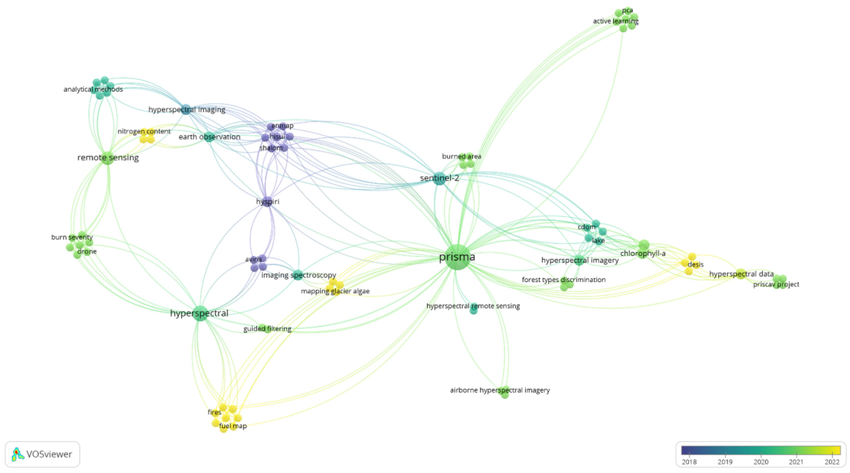
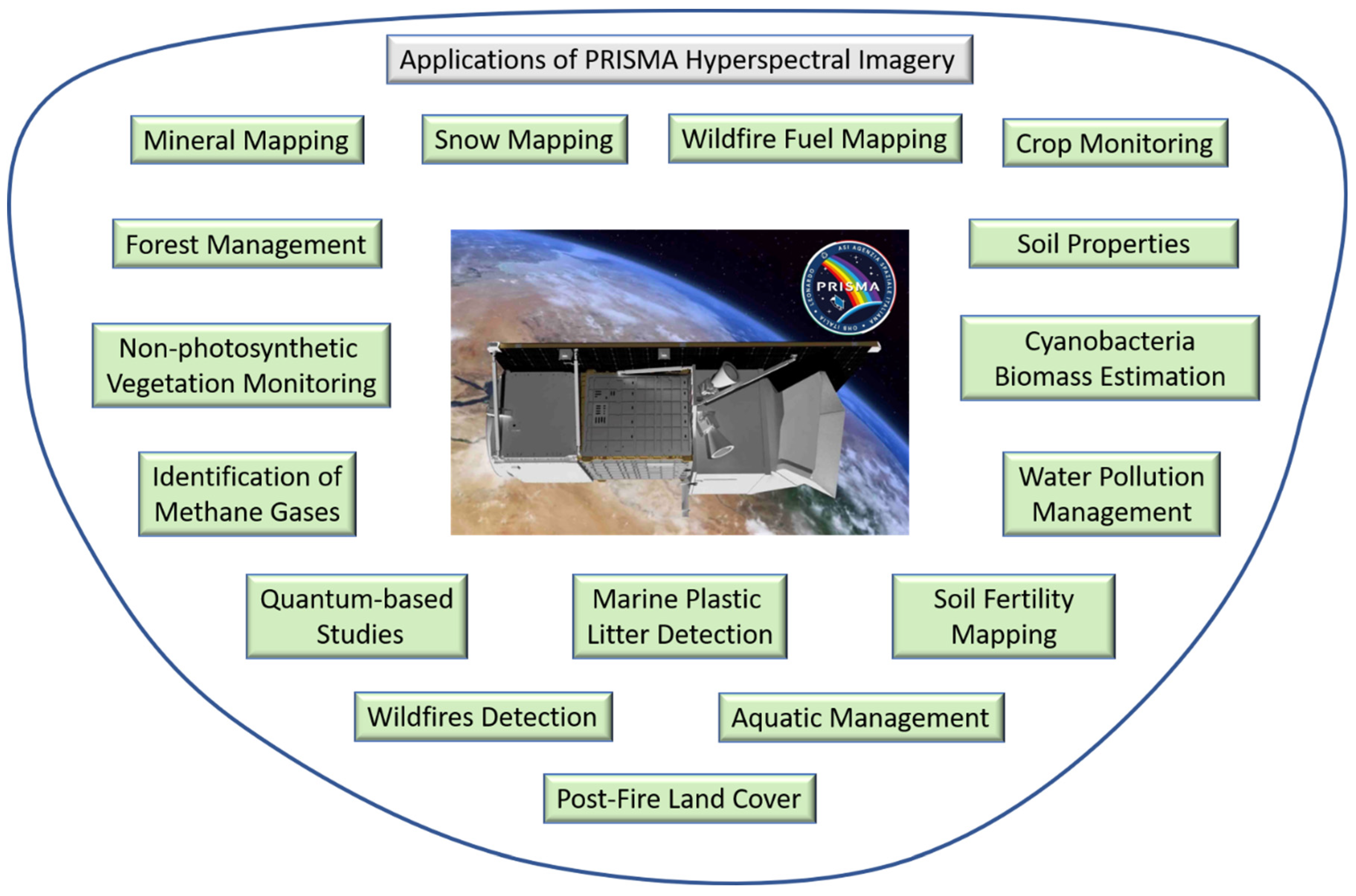
:1. Introduction
2. Materials
2.1. PRISMA Hyperspectral Products
2.2. Assessment of PRISMA
- Strengths
- Weaknesses
- ✓
- Lack of phenological data [6];
- ✓
- Atmospheric correction is not developed for aquatic applications [7];
- ✓
- ✓
- The PRISMA sensor cannot scan at the required angles because there is no scanning mechanism onboard [24];
- ✓
- As vegetation cover is dynamic and fast-changing, timely image acquisitions strongly influence the performance of the PRISMA application. The temporal resolution of PRISMA is an issue [12];
- ✓
- A contiguous spectral response might not detect aliasing between adjacent but different materials. If there is a time lag between scene acquisitions, varying atmospheric and illumination conditions might have a considerable impact on the acquired image [2];
- ✓
- More than 20 bands will contain greater than 50% noise [1];
- ✓
- Irregular noisy bands broaden temporal resolution [1];
- ✓
- Selected bands can have irregular noise values [28];
- ✓
- The spatial resolution of PRISMA data is insufficient for precision farming applications [5].
- Opportunities:
- ✓
- Future algorithms for the routine mapping of vegetation traits from operational spaceborne sensors will be defined [23];
- ✓
- The PRISMA-based retrievals agree well with those of Sentinel-2 (high consistency in top-of-atmosphere radiance), mainly the total suspended matter (TSM) maps [7];
- ✓
- The Coeff (a univariate quadratic function of wavelength), computed from average PRISMA spectra per land parcel, is a significant index for obtaining accurate results with the object-based classification of crops’ single parcels. The main advantage of object-based classification over per-pixel classification is faster computation [13];
- ✓
- PRISMA’s mission aims to demonstrate in-orbit qualification of a state-of-the-art hyperspectral imager, validate end-to-end data processing, and enable environmental monitoring and risk prevention [24];
- ✓
- The combined hyperspectral and panchromatic products enable the recognition of geometric features that provide detailed information about the chemical composition of substances on the Earth’s surface [31];
- ✓
- Unmanned aerial vehicles equipped with UAV platforms and a hyperspectral sensor, and used with PRISMA, can enable the acquisition of ground truth. The PRISMA image can be co-registered with a Sentinel-2 image [12];
- ✓
- PRISMA has better discrimination and a more complex nomenclature system than Sentinel-2; the two can be combined to study the physiochemical and geometric features of a target, contributing to forest analysis, precision agriculture, water quality assessment, and climate change research [2];
- ✓
- Automatic procedures can be applied to develop fuel maps of any part of Europe [1];
- ✓
- Procedures developed for PRISMA will be used globally [28];
- ✓
- Ongoing research will improve PRISMA images [5];
- ✓
- PRISMA data might be fused with data from a panchromatic camera or with satellite data from Landsat and ASTER (advanced spaceborne thermal emission and reflection) [35];
- ✓
- The standard nearest-neighbor method proved to be the most robust on the PRISMA scene [27].
- Threats:
- ✓
- Lack of reference data for model training leads to a decrease in PRISMA accuracy [23];
- ✓
- The one-day time gap between PRISMA and Sentinel-2 leads to differences in their atmospheric corrections [7];
- ✓
- PRISMA is not designed to quantify cellulose abundance or to evaluate species differences [13];
- ✓
- Hyperspectral images should be used with caution when evaluating burned areas after wildfires because of the elapsed time from event to image acquisition [12];
- ✓
- The presence of many shadow areas, where tall and short trees are mixed, can alter the results of separability analysis [2];
- ✓
- Unlike Sentinel-2 data, PRISMA images cannot be downloaded in a cloud platform [1];
- ✓
- Irregular noisy bands can lead to inaccuracies in PRISMA images [1];
- ✓
- The number of noisy bands, the georeferencing, and the levels of data are not yet standardized in PRISMA [28];
- ✓
- As the data and parameters that can be retrieved from PRISMA are often fed into physical models, it is crucial to ensure an extremely accurate radiometric accuracy during the mission lifetime. The COVID-19 pandemic affected the data measurement plan. Further analyses are necessary to confirm the results obtained using PRISMA extreme viewing geometries, including new land cover targets for the spring/summer period when agricultural soil is not plowed [32];
- ✓
- PRISMA-Sentinel-2 data fusion procedures are being tested to search for the best-performing procedure in the PRISMA-Sentinel-2 framework. Sentinel-2 and PRISMA images acquired with very low time differences might not be available [36].
2.3. SWOT Matrix
2.4. Discussion
- Strengths
- Weaknesses
- Opportunities
- Challenges
- Future Scope for PRISMA
3. Conclusions
Author Contributions
Funding
Data Availability Statement
Acknowledgments
Conflicts of Interest
References
- Shaik, R.U.; Laneve, G.; Fusilli, L. An Automatic Procedure for Forest Fire Fuel Mapping Using Hyperspectral (PRISMA) Imagery: A Semi-Supervised Classification Approach. Remote Sens. 2022, 14, 1264. [Google Scholar] [CrossRef]
- Vangi, E.; D’amico, G.; Francini, S.; Giannetti, F.; Lasserre, B.; Marchetti, M.; Chirici, G. The New Hyperspectral Satellite Prisma: Imagery for Forest Types Discrimination. Sensors 2021, 21, 1–19. [Google Scholar] [CrossRef] [PubMed]
- Seydi, S.T.; Hasanlou, M.; Chanussot, J. Dsmnn-Net: A Deep Siamese Morphological Neural Network Model for Burned Area Mapping Using Multispectral Sentinel-2 and Hyperspectral Prisma Images. Remote Sens. 2021, 13, 5138. [Google Scholar] [CrossRef]
- Nesme, N.; Marion, R.; Lezeaux, O.; Doz, S.; Camy-Peyret, C.; Foucher, P.Y. Joint Use of In-Scene Background Radiance Estimation and Optimal Estimation Methods for Quantifying Methane Emissions Using Prisma Hyperspectral Satellite Data: Application to the Korpezhe Industrial Site. Remote Sens. 2021, 13, 4992. [Google Scholar] [CrossRef]
- Lu, B.; Dao, P.D.; Liu, J.; He, Y.; Shang, J. Recent Advances of Hyperspectral Imaging Technology and Applications in Agriculture. Remote Sens. 2020, 12, 2659. [Google Scholar] [CrossRef]
- Salani, G.M.; Lissoni, M.; Natali, S.; Bianchini, G. Geochemical Investigations of 100 Superficial Soils Observed by Sentinel 2 and PRISMA. In Proceedings of the 24th EGU General Assembly, Vienna, Austria, 23–27 May 2022. [Google Scholar] [CrossRef]
- Niroumand-Jadidi, M.; Bovolo, F.; Bruzzone, L. Water Quality Retrieval from PRISMA Hyperspectral Images: First Experience in a Turbid Lake and Comparison with Sentinel-2. Remote Sens. 2020, 12, 1–21. [Google Scholar] [CrossRef]
- Tripathi, P.; Garg, R.D. Feature Extraction of Desis and Prisma Hyperspectral Remote Sensing Datasets for Geological Applications. In Proceedings of the International Archives of the Photogrammetry, Remote Sensing and Spatial Information Sciences—ISPRS Archives, Online, 5–6 October 2021; International Society for Photogrammetry and Remote Sensing: Bethesda, MD, USA, 2021; Volume 44, pp. 169–173. [Google Scholar]
- Lorenz, S.; Seidel, P.; Ghamisi, P.; Zimmermann, R.; Tusa, L.; Khodadadzadeh, M.; Contreras, I.C.; Gloaguen, R. Multi-Sensor Spectral Imaging of Geological Samples: A Data Fusion Approach Using Spatio-Spectral Feature Extraction. Sensors 2019, 19, 2787. [Google Scholar] [CrossRef] [Green Version]
- Shaik, R.U. Prevention and Management of Wildfires: Vulnerability Mapping and Machine Learning-Based Algorithm Development for Fuel Mapping Using Hyperspectral Imagery. Ph.D. Thesis, 2022. [Google Scholar]
- Veraverbeke, S.; Dennison, P.; Gitas, I.; Hulley, G.; Kalashnikova, O.; Katagis, T.; Kuai, L.; Meng, R.; Roberts, D.; Stavros, N. Hyperspectral Remote Sensing of Fire: State-of-the-Art and Future Perspectives. Remote Sens. Environ. 2018, 216, 105–121. [Google Scholar] [CrossRef]
- Lazzeri, G.; Frodella, W.; Rossi, G.; Moretti, S. Multitemporal Mapping of Post-Fire Land Cover Using Multiplatform Prisma Hyperspectral and Sentinel-Uav Multispectral Data: Insights from Case Studies in Portugal and Italy. Sensors 2021, 21, 3982. [Google Scholar] [CrossRef]
- Pepe, M.; Pompilio, L.; Gioli, B.; Busetto, L.; Boschetti, M. Detection and Classification of Non-Photosynthetic Vegetation from Prisma Hyperspectral Data in Croplands. Remote Sens. 2020, 12, 1–12. [Google Scholar] [CrossRef]
- Bohn, N.; di Mauro, B.; Colombo, R.; Thompson, D.R.; Susiluoto, J.; Carmon, N.; Turmon, M.J.; Guanter, L. Glacier Ice Surface Properties in South-West Greenland Ice Sheet: First Estimates from PRISMA Imaging Spectroscopy Data. J. Geophys. Res. Biogeosci. 2022, 127. [Google Scholar] [CrossRef]
- Bresciani, M.; Giardino, C.; Fabbretto, A.; Pellegrino, A.; Mangano, S.; Free, G.; Pinardi, M. Application of New Hyperspectral Sensors in the Remote Sensing of Aquatic Ecosystem Health: Exploiting PRISMA and DESIS for Four Italian Lakes. Resources 2022, 11, 8. [Google Scholar] [CrossRef]
- Kokal, A.T.; Ismailoglu, I.; Musaoglu, N. Comparison of Landsat-9 And Prisma Satellite Data for Land Use/Land Cover Classification. In Proceedings of the International Archives of the Photogrammetry, Remote Sensing and Spatial Information Sciences—ISPRS Archives, Nice, France, 6–11 June 2022; International Society for Photogrammetry and Remote Sensing: Bethesda, MD, USA, 2022; Volume 46, pp. 197–201. [Google Scholar]
- Hajizadeh, Y. Machine Learning in Oil and Gas; a SWOT Analysis Approach. J. Pet. Sci. Eng. 2019, 176, 661–663. [Google Scholar] [CrossRef]
- Benzaghta, M.A.; Elwalda, A.; Mousa, M.; Erkan, I.; Rahman, M. SWOT Analysis Applications: An Integrative Literature Review. J. Glob. Bus. Insights 2021, 6, 55–73. [Google Scholar] [CrossRef]
- Nezhad, M.M.; Shaik, R.U.; Heydari, A.; Razmjoo, A.; Arslan, N.; Garcia, D.A. A SWOT Analysis for Offshore Wind Energy Assessment Using Remote-Sensing Potential. Appl. Sci. 2020, 10, 6398. [Google Scholar] [CrossRef]
- Supriyasilp, T.; Pongput, K.; Boonyanupong, S.; Suwanlertcharoen, T. Enhanced Water Management for Muang Fai Irrigation Systems through Remote Sensing and SWOT Analysis. Water Resour. Manag. 2021, 35, 263–277. [Google Scholar] [CrossRef]
- Cogliati, S.; Sarti, F.; Chiarantini, L.; Cosi, M.; Lorusso, R.; Lopinto, E.; Miglietta, F.; Genesio, L.; Guanter, L.; Damm, A.; et al. The PRISMA Imaging Spectroscopy Mission: Overview and First Performance Analysis. Remote. Sens. Environ. 2021, 262. [Google Scholar] [CrossRef]
- Santini, F.; Palombo, A. Impact of Topographic Correction on PRISMA Sentinel 2 and Landsat 8 Images. Remote Sens. 2022, 14, 3903. [Google Scholar] [CrossRef]
- Tagliabue, G.; Boschetti, M.; Bramati, G.; Candiani, G.; Colombo, R.; Nutini, F.; Pompilio, L.; Rivera-Caicedo, J.P.; Rossi, M.; Rossini, M.; et al. Hybrid Retrieval of Crop Traits from Multi-Temporal PRISMA Hyperspectral Imagery. ISPRS J. Photogramm. Remote Sens. 2022, 187, 362–377. [Google Scholar] [CrossRef]
- Coppo, P.; Brandani, F.; Faraci, M.; Sarti, F.; Cosi, M. Leonardo Spaceborne Infrared Payloads for Earth Observation: SLSTRs for Copernicus Sentinel 3 and PRISMA Hyperspectral Camera for PRISMA Satellite. Appl. Opt. 2020, 59, 6888. [Google Scholar] [CrossRef]
- Kremezi, M.; Kristollari, V.; Karathanassi, V.; Topouzelis, K.; Kolokoussis, P.; Taggio, N.; Aiello, A.; Ceriola, G.; Barbone, E.; Corradi, P. Pansharpening PRISMA Data for Marine Plastic Litter Detection Using Plastic Indexes. IEEE Access 2021, 9, 61955–61971. [Google Scholar] [CrossRef]
- Giardino, C.; Bresciani, M.; Fabbretto, A.; Ghirardi, N.; Mangano, S.; Pellegrino, A.; Vaiciute, D.; Braga, F.; Brando, V.E.; Laanen, M.; et al. Hyperspectral Prisma Products of Aquatic Systems. In Proceedings of the International Geoscience and Remote Sensing Symposium (IGARSS), Brussels, Belgium, 11–16 July 2021; Institute of Electrical and Electronics Engineers Inc.: New York, NY, USA, 2021; pp. 1229–1232. [Google Scholar]
- Berger, K.; Hank, T.; Halabuk, A.; Rivera-Caicedo, J.P.; Wocher, M.; Mojses, M.; Gerhátová, K.; Tagliabue, G.; Dolz, M.M.; Venteo, A.B.P.; et al. Assessing Non-Photosynthetic Cropland Biomass from Spaceborne Hyperspectral Imagery. Remote Sens. 2021, 13, 4711. [Google Scholar] [CrossRef] [PubMed]
- Shaik, R.U.; Giovanni, L.; Fusilli, L. New Approach of Sample Generation And Classification for Wildfire Fuel Mapping on Hyperspectral (Prisma) Image. In Proceedings of the International Geoscience and Remote Sensing Symposium (IGARSS), Brussels, Belgium, 11–16 July 2021; Institute of Electrical and Electronics Engineers Inc.: New York, NY, USA, 2021; pp. 5417–5420. [Google Scholar]
- Pearlshtien, D.H.; Pignatti, S.; Ben-Dor, E. Vicarious. CAL/VAL Approach for Orbital Hyperspectral Sensors Using Multiple Sites. Remote Sens. 2023, 15, 771. [Google Scholar] [CrossRef]
- Hank, T.; Berger, K.; Wocher, M.; Danner, M.; Mauser, W. Introducing the Potential of The Enmap-Box for Agricultural Applications Using Desis And Prisma Data. In Proceedings of the International Geoscience and Remote Sensing Symposium (IGARSS), Waikoloa, HI, USA, 26 September–2 October 2020; Institute of Electrical and Electronics Engineers Inc.: New York, NY, USA, 2021; pp. 467–470. [Google Scholar]
- Guarini, R.; Loizzo, R.; Facchinetti, C.; Longo, F.; Ponticelli, B.; Faraci, M.; Dami, M.; Cosi, L.; Amoruso, V.; De Pasquale, N.; et al. PRISMA Hyperspectral Mission Products. In Proceedings of the IGARSS 2018-2018 IEEE International Geoscience and Remote Sensing Symposium, Valencia, Spain, 22–27 July 2018; IEEE: New York, NY, USA, 2018; pp. 179–182. [Google Scholar]
- Pignatti, S.; Amodeo, A.; Mona, L.; Palombo, A.; Pascucci, S.; Rosoldi, M.; Santini, F.; Casa, R.; Laneve, G. Evaluation of the Prisma Hyperspectral Radiance Data: The Priscav Project Activities in The Basilicata Region (Southern Italy). In Proceedings of the International Geoscience and Remote Sensing Symposium (IGARSS), Brussels, Belgium, 11–16 July 2021; Institute of Electrical and Electronics Engineers Inc.: New York, NY, USA, 2021; pp. 1390–1393. [Google Scholar]
- Transon, J.; d’Andrimont, R.; Maugnard, A.; Defourny, P. Survey of Hyperspectral Earth Observation Applications from Space in the Sentinel-2 Context. Remote Sens. 2018, 10, 157. [Google Scholar] [CrossRef] [Green Version]
- Spiller, D.; Ansalone, L.; Carotenuto, F.; Mathieu, P.P. Crop Type Mapping Using Prisma Hyperspectral Images and One-Dimensional Convolutional Neural Network. In Proceedings of the International Geoscience and Remote Sensing Symposium (IGARSS), Brussels, Belgium, 11–16 July 2021; Institute of Electrical and Electronics Engineers Inc.: New York, NY, USA, 2021; pp. 8166–8169. [Google Scholar]
- Buongiorno, M.F.; Musacchio, M.; Silvestri, M.; Romaniello, V.; Spinetti, C.; Rabuffi, F. Asi-Prisma Hyperspectral Mission for the Analysis of Geophysical Phenomena. In Proceedings of the International Geoscience and Remote Sensing Symposium (IGARSS), Brussels, Belgium, 11–16 July 2021; Institute of Electrical and Electronics Engineers Inc.: New York, NY, USA, 2021; pp. 8099–8102. [Google Scholar]
- Acito, N.; Diani, M.; Corsini, G. PRISMA Spatial Resolution Enhancement by Fusion with Sentinel-2 Data. IEEE J. Sel. Top. Appl. Earth. Obs. Remote Sens. 2022, 15, 62–79. [Google Scholar] [CrossRef]
- Mallinis, G.; Galidaki, G.; Gitas, I. A Comparative Analysis of EO-1 Hyperion, Quickbird and Landsat TM Imagery for Fuel Type Mapping of a Typical Mediterranean Landscape. Remote Sens. 2014, 6, 1684–1704. [Google Scholar] [CrossRef] [Green Version]
- Badola, A.; Panda, S.K.; Roberts, D.A.; Waigl, C.F.; Bhatt, U.S.; Smith, C.W.; Jandt, R.R. Hyperspectral Data Simulation (Sentinel-2 to Aviris-Ng) for Improved Wildfire Fuel Mapping, Boreal Alaska. Remote Sens. 2021, 13, 1693. [Google Scholar] [CrossRef]
- Stefanidou, A.; Gitas, I.Z.; Katagis, T. A National Fuel Type Mapping Method Improvement Using Sentinel-2 Satellite Data. Geocarto. Int. 2022, 37, 1022–1042. [Google Scholar] [CrossRef]
- Cavalli, R.M. The Weight of Hyperion and PRISMA Hyperspectral Sensor Characteristics on Image Capability to Retrieve Urban Surface Materials in the City of Venice. Sensors 2023, 23, 454. [Google Scholar] [CrossRef]
- Huang, S.; Crabtree, R.L.; Potter, C.; Gross, P. Estimating the Quantity and Quality of Coarse Woody Debris in Yellowstone Post-Fire Forest Ecosystem from Fusion of SAR and Optical Data. Remote Sens. Environ. 2009, 113, 1926–1938. [Google Scholar] [CrossRef]
- Pham, M.T.; Rajić, A.; Greig, J.D.; Sargeant, J.M.; Papadopoulos, A.; McEwen, S.A. A Scoping Review of Scoping Reviews: Advancing the Approach and Enhancing the Consistency. Res. Synth. Methods 2014, 5, 371–385. [Google Scholar] [CrossRef] [Green Version]
- Bruelheide, H.; Dengler, J.; Purschke, O.; Lenoir, J.; Jiménez-Alfaro, B.; Hennekens, S.M.; Botta-Dukát, Z.; Chytrý, M.; Field, R.; Jansen, F.; et al. Global Trait–Environment Relationships of Plant Communities. Nat. Ecol. Evol. 2018, 2, 1906–1917. [Google Scholar] [CrossRef]
- Ferster, C.J.; Coops, N.C. Integrating Volunteered Smartphone Data with Multispectral Remote Sensing to Estimate Forest Fuels. Int. J. Digit. Earth 2016, 9, 171–196. [Google Scholar] [CrossRef]
- Moran, C.J.; Kane, V.R.; Seielstad, C.A. Mapping Forest Canopy Fuels in Thewestern United States with LiDAR-Landsat Covariance. Remote Sens. 2020, 12, 1000. [Google Scholar] [CrossRef] [Green Version]
- Engelstad, P.S.; Falkowski, M.; Wolter, P.; Poznanovic, A.; Johnson, P. Estimating Canopy Fuel Attributes from Low-Density Lidar. Fire 2019, 2, 1–19. [Google Scholar] [CrossRef] [Green Version]
- Erdody, T.L.; Moskal, L.M. Fusion of LiDAR and Imagery for Estimating Forest Canopy Fuels. Remote Sens. Environ. 2010, 114, 725–737. [Google Scholar] [CrossRef]
- Stavros, E.N.; Coen, J.; Peterson, B.; Singh, H.; Kennedy, K.; Ramirez, C.; Schimel, D. Use of Imaging Spectroscopy and LIDAR to Characterize Fuels for Fire Behavior Prediction. Remote Sens. Appl. 2018, 11, 41–50. [Google Scholar] [CrossRef]
- Aneece, I.; Thenkabail, P.S. New Generation Hyperspectral Sensors DESIS and PRISMA Provide Improved Agricultural Crop Classifications. Photogramm. Eng. Remote Sens. 2022, 88, 715–729. [Google Scholar] [CrossRef]
- Vane, G.; Goetz, A.F.H.; Wellman, J.B. Airborne Imaging Spectrometer: A New Tool for Remote Sensing. IEEE Trans. Geosci. Remote Sens. 1984, GE-22, 546–549. [Google Scholar] [CrossRef]
- Sobrino, J.A.; Jiménez-Muñoz, J.C.; Zarco-Tejada, P.J.; Sepulcre-Cantó, G.; de Miguel, E. Land Surface Temperature Derived from Airborne Hyperspectral Scanner Thermal Infrared Data. Remote Sens. Environ. 2006, 102, 99–115. [Google Scholar] [CrossRef]
- Rogge, D.; Rivard, B.; Segl, K.; Grant, B.; Feng, J. Mapping of NiCu–PGE Ore Hosting Ultramafic Rocks Using Airborne and Simulated EnMAP Hyperspectral Imagery, Nunavik, Canada. Remote Sens. Environ. 2014, 152, 302–317. [Google Scholar] [CrossRef]
- Muller, A.; Richter, R.; Habermeyer, M.; Dech, S.; Segl, K.; Kaufmann, H. Spectroradiometric Requirements for the Reflective Module of the Airborne Spectrometer ARES. IEEE Geosci. Remote Sens. Lett. 2005, 2, 329–332. [Google Scholar] [CrossRef]
- Schaepman, M.E.; Jehle, M.; Hueni, A.; D’Odorico, P.; Damm, A.; Weyermann, J.; Schneider, F.D.; Laurent, V.; Popp, C.; Seidel, F.C.; et al. Advanced Radiometry Measurements and Earth Science Applications with the Airborne Prism Experiment (APEX). Remote Sens. Environ. 2015, 158, 207–219. [Google Scholar] [CrossRef] [Green Version]
- Gaddis, L.R.; Soderblom, L.A.; Kieffer, H.H.; Becker, K.J.; Torson, J.; Mullins, K. Decomposition of AVIRIS Spectra: Extraction of Surface-Reflectance, Atmospheric, and Instrumental Components. IEEE Trans. Geosci. Remote Sens. 1996, 34, 163–178. [Google Scholar] [CrossRef]
- Resmini, R.G.; Kappus, M.E.; Aldrich, W.S.; Harsanyi, J.C.; Anderson, M. Mineral Mapping with HYperspectral Digital Imagery Collection Experiment (HYDICE) Sensor Data at Cuprite, Nevada, U.S.A. Int. J. Remote Sens. 1997, 18, 1553–1570. [Google Scholar] [CrossRef]
- Plaza, A.; Martinez, P.; Plaza, J.; Perez, R. Dimensionality Reduction and Classification of Hyperspectral Image Data Using Sequences of Extended Morphological Transformations. IEEE Trans. Geosci. Remote Sens. 2005, 43, 466–479. [Google Scholar] [CrossRef] [Green Version]
- Hörig, B.; Kühn, F.; Oschütz, F.; Lehmann, F. HyMap Hyperspectral Remote Sensing to Detect Hydrocarbons. Int. J. Remote Sens. 2001, 22, 1413–1422. [Google Scholar] [CrossRef]
- DU, P.; TAN, K.; SU, H. Feature Extraction for Target Identification and Image Classification of OMIS Hyperspectral Image. Min. Sci. Technol. 2009, 19, 835–841. [Google Scholar] [CrossRef]
- Belluco, E.; Camuffo, M.; Ferrari, S.; Modenese, L.; Silvestri, S.; Marani, A.; Marani, M. Mapping Salt-Marsh Vegetation by Multispectral and Hyperspectral Remote Sensing. Remote Sens. Environ. 2006, 105, 54–67. [Google Scholar] [CrossRef]
- Alessia, T.; Avolio, C.; Casa, R.; Costantini, M.; Magliozzi, M.L.; Pascucci, S.; Pignatti, S.; Mzid, N.; Palandri, M.; Sacco, P.; et al. A Prototype Processor for Vegetation Traits Retrieval from PRISMA Hyperspectral Data. In Proceedings of the ASITA, Genoa, Italy, 20–24 June 2021; pp. 573–574. [Google Scholar]
- Magliozzi, M.L.; Avolio, C.; Braga, F.; Bresciani, M.; Costantini, M.; Fabbretto, A.; Giardino, C.; Palandri, M.; Pellegrino, A.; Scarpa, G.M.; et al. The Water Quality Prototype Exploiting PRISMA Hyperspectral Data for Aquatic Ecosystems Mapping. In Proceedings of the ASITA, Genoa, Italy, 20–24 June 2021; pp. 345–346. [Google Scholar]
- Romaniello, V.; Buongiorno, M.F.; Spinetti, C.; Silvestri, M. Analysis of Volcanic Carbon Dioxide Emissions by Means of Prisma Hyperspectral Data and in Situ Measurements. In Proceedings of the IGARSS 2022–2022 IEEE International Geoscience and Remote Sensing Symposium, Kuala Lumpur, Malaysia, 17–22 July 2022; IEEE: New York, NY, USA, 2022; pp. 7268–7271. [Google Scholar]
- Italian Space Agency. Available online: https://www.asi.it/en/earth-science/prisma/ (accessed on 16 January 2023).
- Laneve, G.; Shaik, R.U. Forest Fire Fuel Map from PRISMA Hyperspectral Data: Algorithms and First Results. In Proceedings of the Living Planet Symposium, Bonn, Germany, 23–27 May 2022. [Google Scholar]
- Ertürk, A.; Erten, E. Unmixing of pollution-associated sea-snot in the near-surface after its outbreak in the Sea of Marmara using hyperspectral PRISMA data. IEEE Geosci. Remote Sens. Lett. 2023, 20, 1–5. [Google Scholar] [CrossRef]
- Hamzeh, S.; Hajeb, M.; Alavipanah, S.K.; Verrelst, J. Retrieval of Sugarcane Leaf Area Index From Prisma Hyperspectral Data. ISPRS Ann. Photogramm. Remote Sens. Spatial Inf. Sci. 2023, X-4/W1-202, 271–277. [Google Scholar] [CrossRef]
- Thangavel, K.; Spiller, D.; Sabatini, R.; Amici, S.; Sasidharan, S.T.; Fayek, H.; Marzocca, P. Autonomous Satellite Wildfire Detection Using Hyperspectral Imagery and Neural Networks: A Case Study on Australian Wildfire. Remote Sens. 2023, 15, 720. [Google Scholar] [CrossRef]
- O'Shea, R.E.; Pahlevan, N.; Smith, B.; Bresciani, M.; Egerton, T.; Giardino, C.; Li, L.; Moore, T.; Ruiz-Verdu, A.; Ruberg, S.; et al. Advancing cyanobacteria biomass estimation from hyperspectral observations: Demonstrations with HICO and PRISMA imagery. Remote. Sens. Environ. 2021, 266, 112693. [Google Scholar] [CrossRef]
- Ranghetti, L.; Boschetti, M.; Nutini, F.; Busetto, L. “Sen2r”: An R Toolbox for Automatically Downloading and Preprocessing Sentinel-2 Satellite Data. Comput. Geosci. 2020, 139, 104473. [Google Scholar] [CrossRef]
- Mulero-Martinez, R.; Román-Cascón, C.; Mañanes, R.; Izquierdo, A.; Bruno, M.; Gómez-Enri, J. The Use of Sentinel-3 Altimetry Data to Assess Wind Speed from the Weather Research and Forecasting (WRF) Model: Application over the Gulf of Cadiz. Remote Sens. 2022, 14, 4036. [Google Scholar] [CrossRef]
- Shaik, R.U.; Unni, A.; Zeng, W. Quantum Based Pseudo-Labelling for Hyperspectral Imagery: A Simple and Efficient Semi-Supervised Learning Method for Machine Learning Classifiers. Remote Sens. 2022, 14, 5774. [Google Scholar] [CrossRef]
- Mutlu, M.; Popescu, S.C.; Zhao, K. Sensitivity Analysis of Fire Behavior Modeling with LIDAR-Derived Surface Fuel Maps. For. Ecol. Manag. 2008, 256, 289–294. [Google Scholar] [CrossRef]
- Mutlu, M.; Popescu, S.C.; Stripling, C.; Spencer, T. Mapping Surface Fuel Models Using Lidar and Multispectral Data Fusion for Fire Behavior. Remote Sens. Environ. 2008, 112, 274–285. [Google Scholar] [CrossRef]
- Gasmi, A.; Gomez, C.; Chehbouni, A.; Dhiba, D.; el Gharous, M. Using PRISMA Hyperspectral Satellite Imagery and GIS Approaches for Soil Fertility Mapping (FertiMap) in Northern Morocco. Remote Sens. 2022, 14, 4080. [Google Scholar] [CrossRef]
- Ghamisi, P.; Hofle, B.; Zhu, X.X. Hyperspectral and LiDAR Data Fusion Using Extinction Profiles and Deep Convolutional Neural Network. IEEE J. Sel. Top. Appl. Earth Obs. Remote. Sens. 2016, 10, 3011–3024. [Google Scholar] [CrossRef]
- Shaik, R.U.; Periasamy, S. Accuracy and Processing Speed Trade-Offs in Classical and Quantum SVM Classifier Exploiting PRISMA Hyperspectral Imagery. Int. J. Remote Sens. 2022, 43, 6176–6194. [Google Scholar] [CrossRef]
- Li, H.; Ghamisi, P.; Soergel, U.; Zhu, X.X. Hyperspectral and LiDAR Fusion Using Deep Three-Stream Convolutional Neural Networks. Remote Sens. 2018, 10, 1649. [Google Scholar] [CrossRef] [Green Version]


| Technology | Internal | External |
|---|---|---|
| Positives | Strengths:
| Opportunities:
|
| Negatives | Weaknesses:
| Threats:
|
Disclaimer/Publisher’s Note: The statements, opinions and data contained in all publications are solely those of the individual author(s) and contributor(s) and not of MDPI and/or the editor(s). MDPI and/or the editor(s) disclaim responsibility for any injury to people or property resulting from any ideas, methods, instructions or products referred to in the content. |
© 2023 by the authors. Licensee MDPI, Basel, Switzerland. This article is an open access article distributed under the terms and conditions of the Creative Commons Attribution (CC BY) license (https://creativecommons.org/licenses/by/4.0/).
Share and Cite
Shaik, R.U.; Periasamy, S.; Zeng, W. Potential Assessment of PRISMA Hyperspectral Imagery for Remote Sensing Applications. Remote Sens. 2023, 15, 1378. https://doi.org/10.3390/rs15051378
Shaik RU, Periasamy S, Zeng W. Potential Assessment of PRISMA Hyperspectral Imagery for Remote Sensing Applications. Remote Sensing. 2023; 15(5):1378. https://doi.org/10.3390/rs15051378
Chicago/Turabian StyleShaik, Riyaaz Uddien, Shoba Periasamy, and Weiping Zeng. 2023. "Potential Assessment of PRISMA Hyperspectral Imagery for Remote Sensing Applications" Remote Sensing 15, no. 5: 1378. https://doi.org/10.3390/rs15051378