
Water-Body Segmentation for SAR Images: Past, Current, and Future

 , and
, and
Abstract
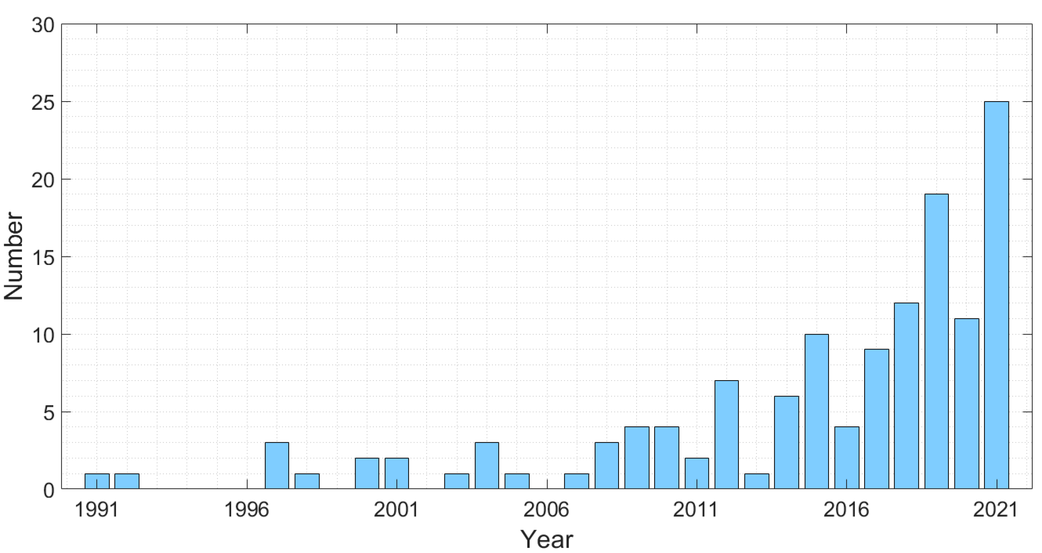
:1. Introduction
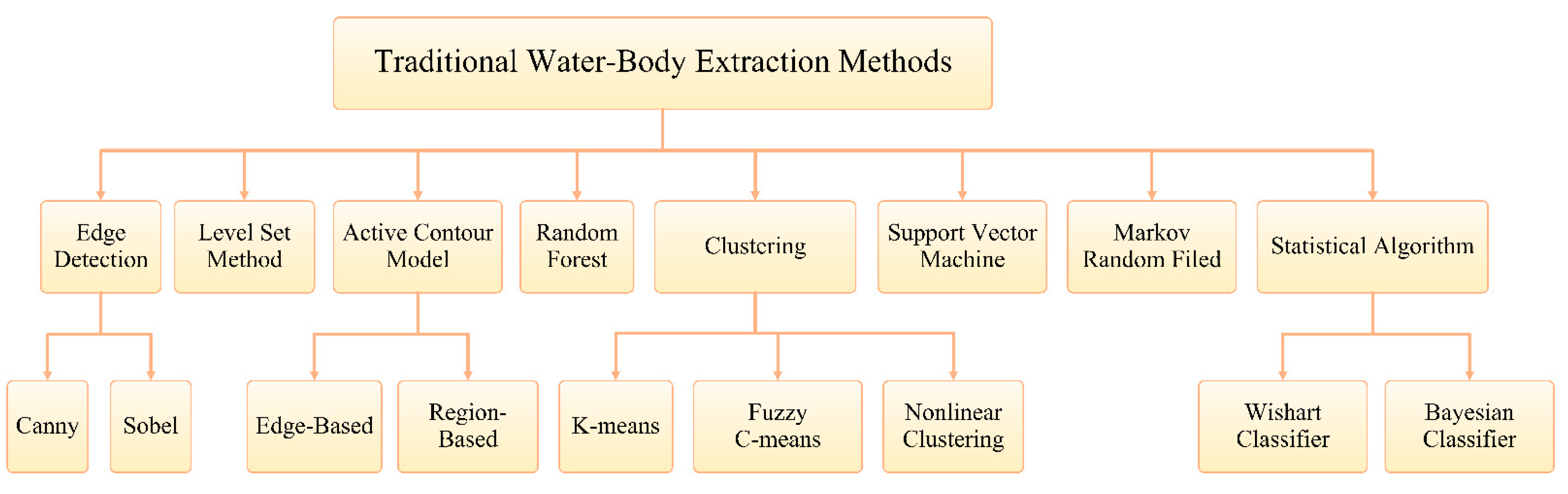
2. Traditional Water Body Extraction Methods for SAR Images
2.1. Edge Detection
2.1.1. Canny Edge Detection
2.1.2. Sobel Edge Detection
2.2. Level Set Method
2.3. Active Contour Model
2.3.1. Edge-Based Active Contour Model
2.3.2. Region-Based Active Contour Model
2.4. Clustering Methods
2.4.1. K-Means
2.4.2. Fuzzy C-Means
2.4.3. Nonlinear Clustering Method
2.5. Random Forest
2.6. Support Vector Machine
2.7. Markov Random Field
2.8. Mathematical Statistical Algorithm
2.8.1. Wishart Classifier
2.8.2. Bayesian Classifier
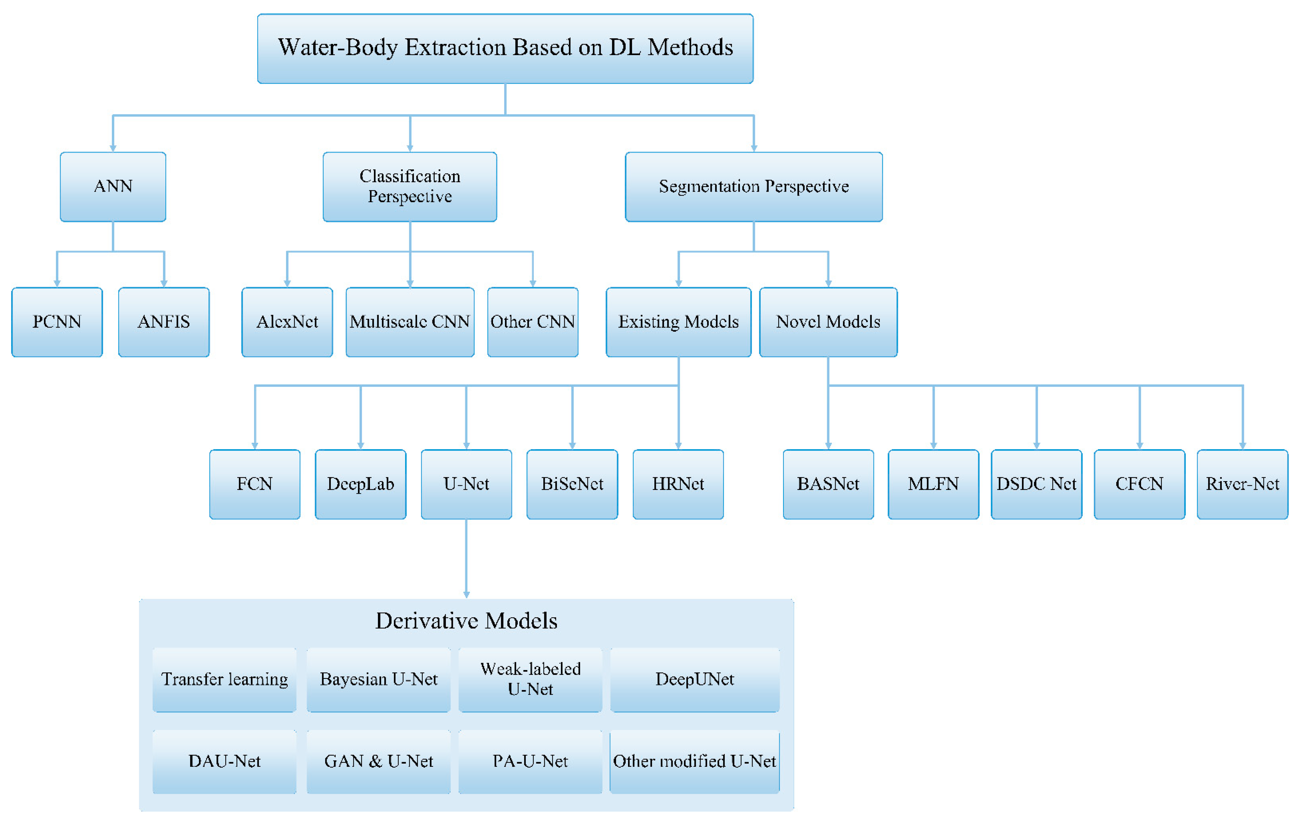
3. Water-Body Extraction from SAR Images Based on DL
3.1. Background of DL in Remote Sensing Field
3.2. Pixel Level Water Body Classification Based on CNN
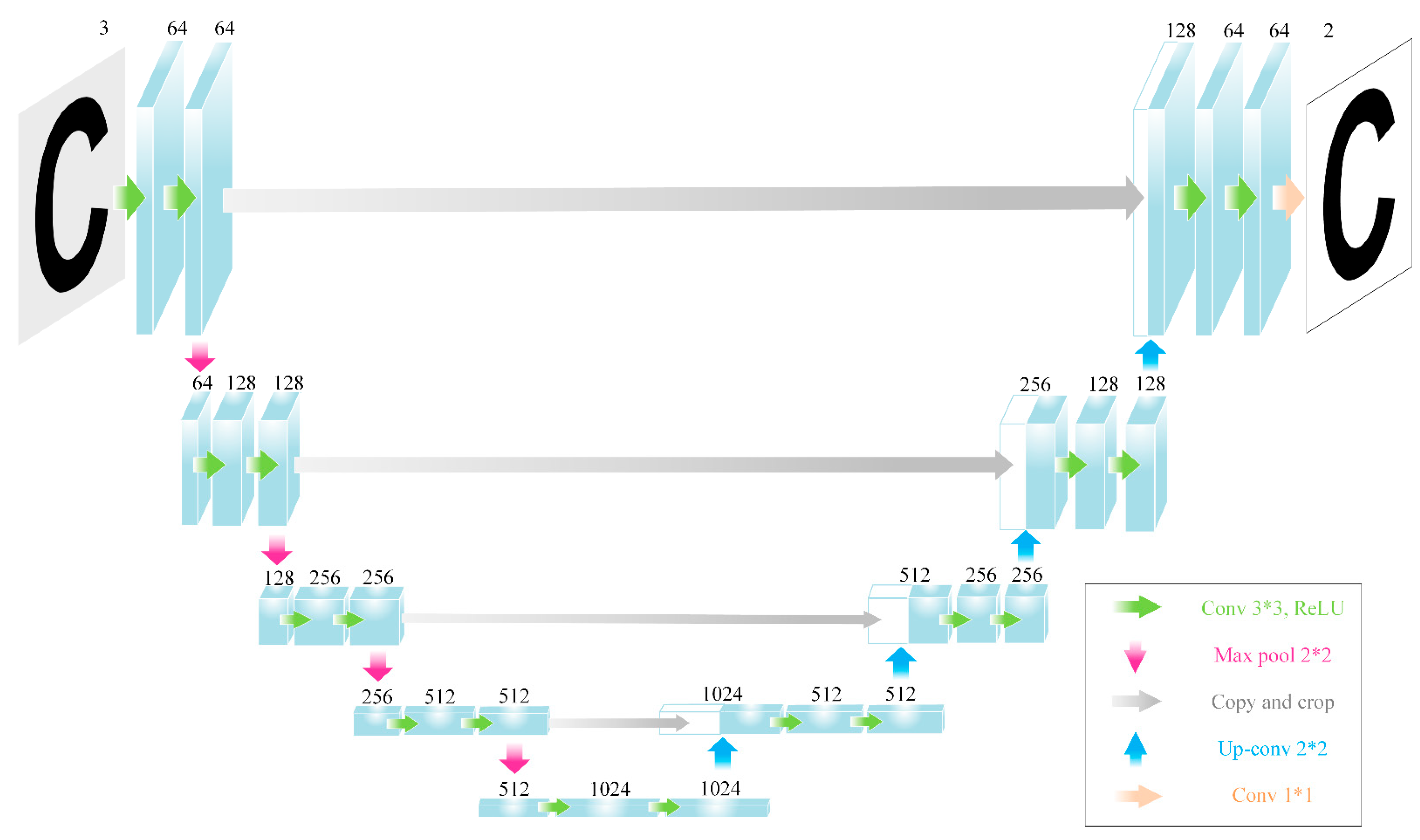
3.3. Image Level Water-Body Segmentation Based on CNN
3.3.1. Water-Body Segmentation Based on Existing Network Model
3.3.2. Water-Body Segmentation Based on Novel Network Models
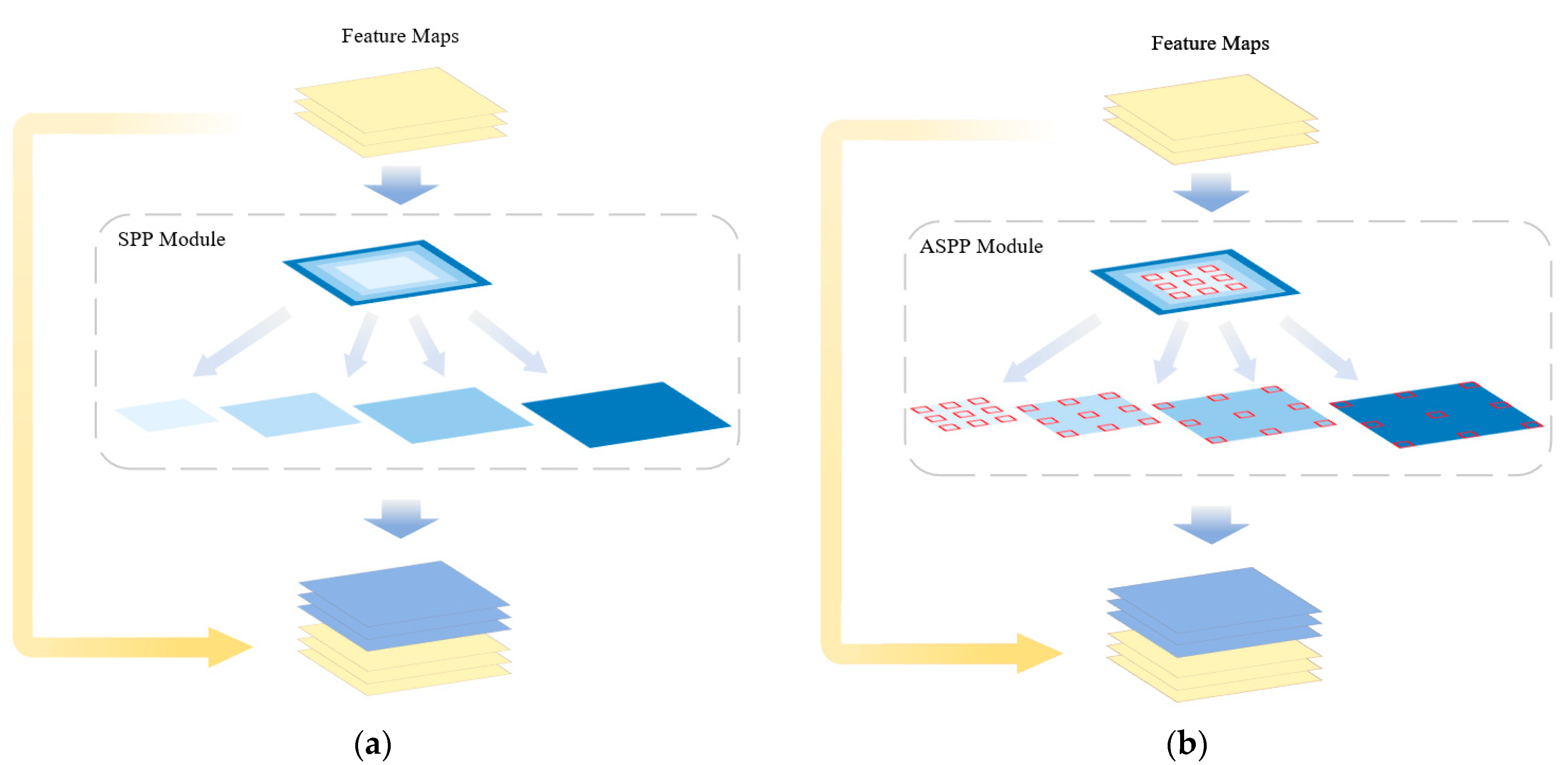
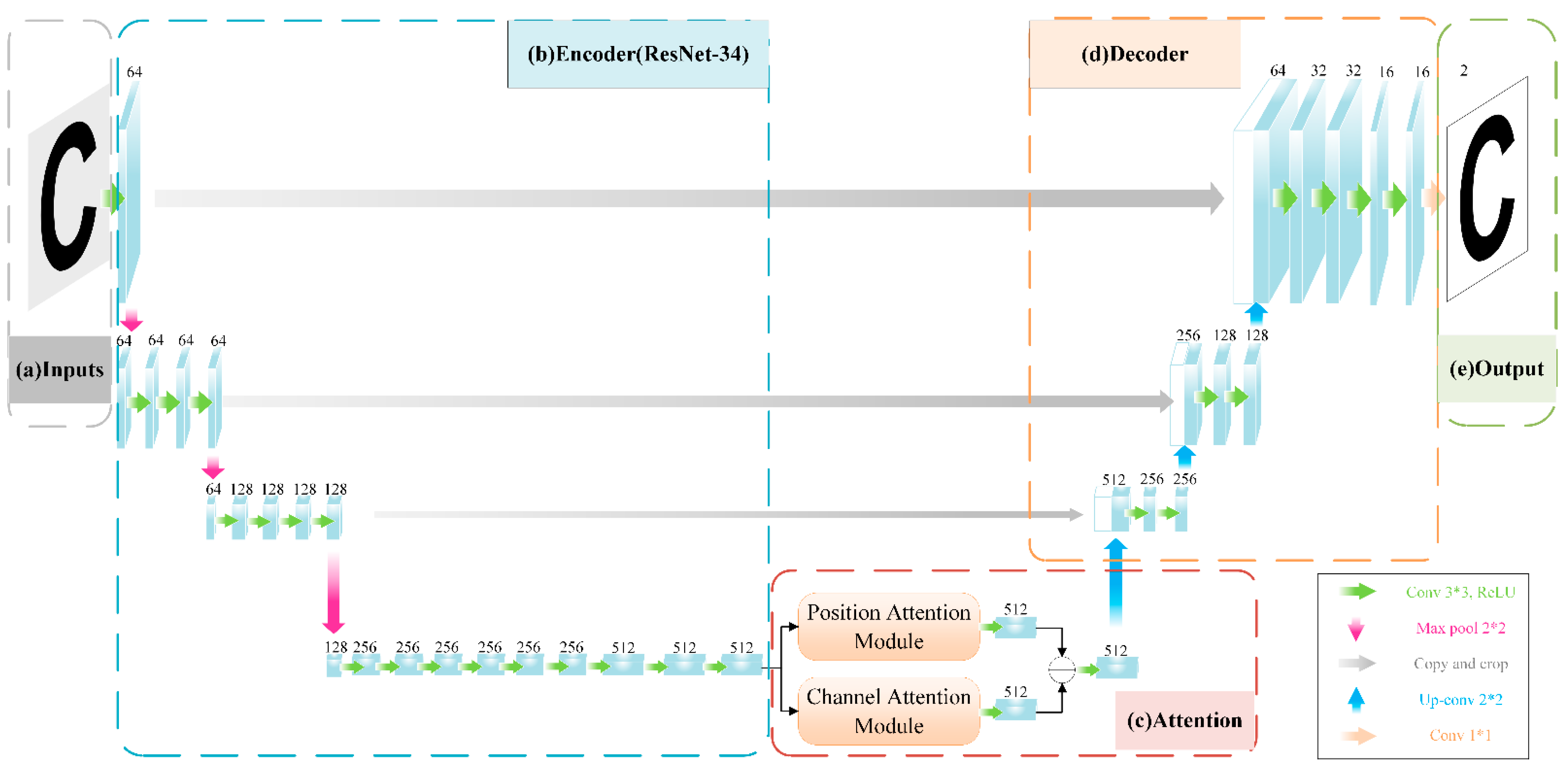
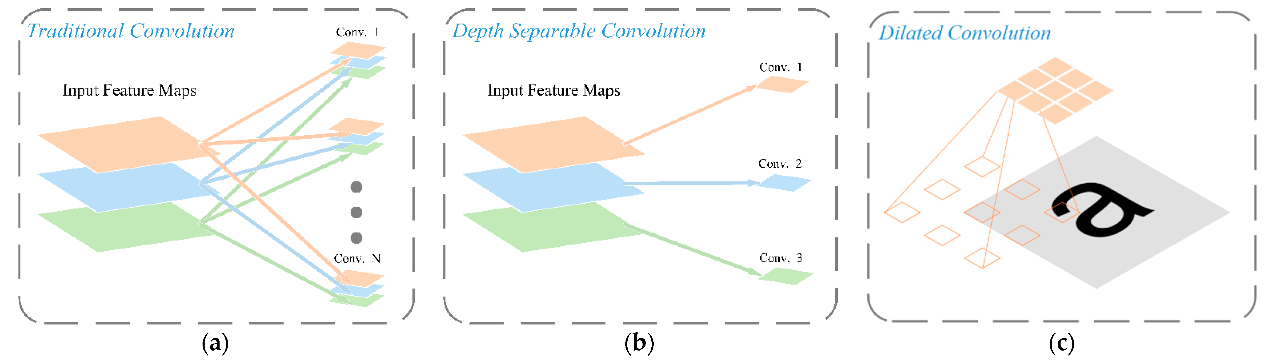
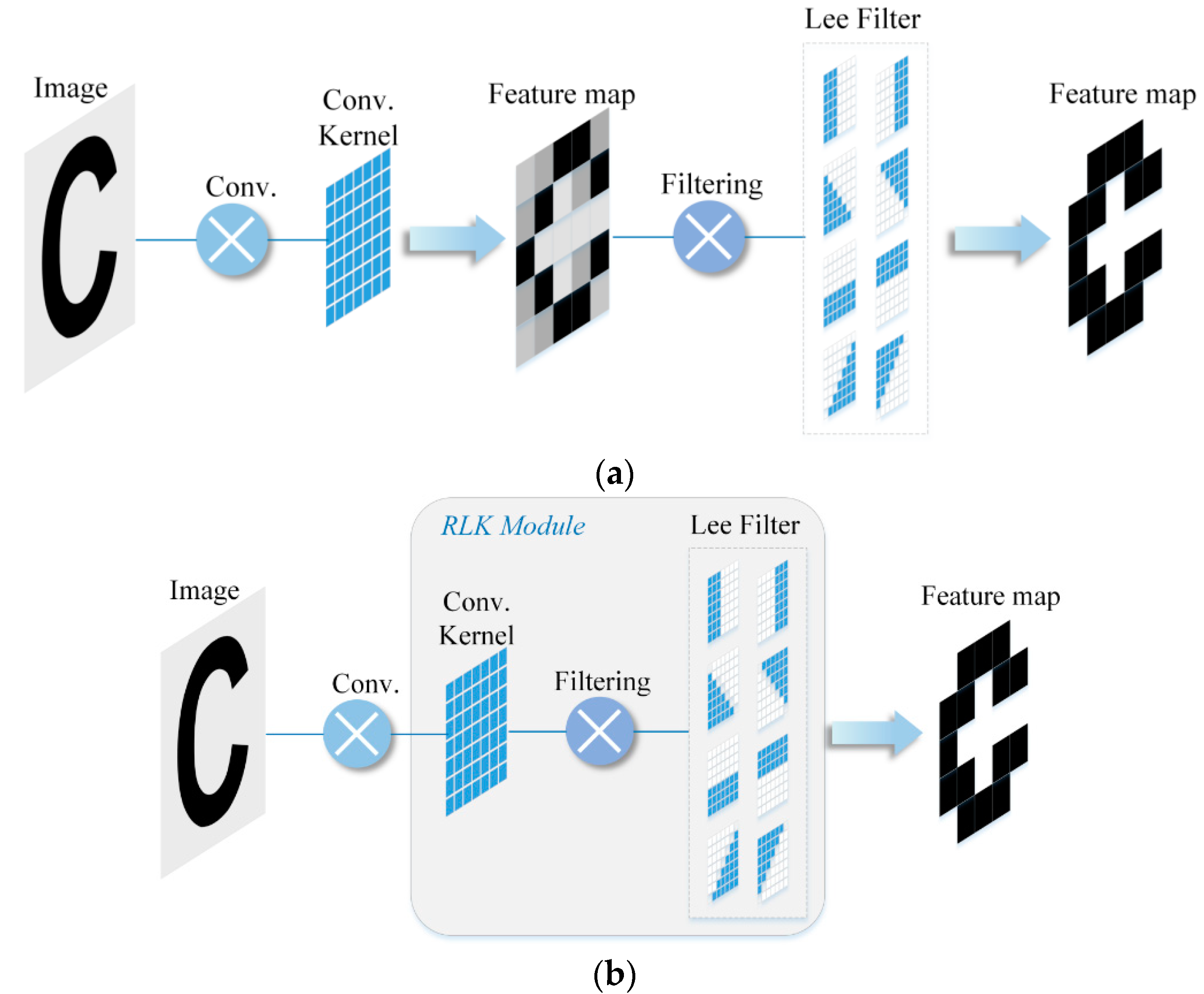
3.3.3. Portable Module in Neural Network for Water-Body Segmentation
4. Conclusions and Future Prospects
4.1. Conclusions
4.2. Future Prospects
- Exploit the characteristics of the SAR image itself, making full use of more amplitude, phase and complex information of SAR;
- Explore the solutions for small-scale SAR data to train network models, and data augmentation methods to weaken the imbalance of datasets;
- Develop novel modules suitable for water body extraction from SAR images and integrate existing excellent modules.
Author Contributions
Funding
Institutional Review Board Statement
Informed Consent Statement
Data Availability Statement
Conflicts of Interest
References
- Li, N.; Lv, Z.; Guo, Z. SAR image interference suppression method by integrating change detection and subband spectral cancellation technology. Syst. Eng. Electron. 2021, 43, 2484–2492. [Google Scholar]
- Chen, J.; Lv, J.; Li, N.; Qang, Q.; Wang, J. External groundwater alleviates the degradation of closed lakes in semi-arid regions of China. Remote Sens. 2020, 12, 45. [Google Scholar] [CrossRef] [Green Version]
- Pradhan, B.; Sameen, M.; Kalantar, B. Optimized Rule-Based Flood Mapping Technique Using Multitemporal RADARSAT-2 Images in the Tropical Region. IEEE J. Sel. Top. Appl. Earth Obs. Remote Sens. 2017, 10, 3190–3199. [Google Scholar] [CrossRef]
- Kim, M.; Oh, H.; Lee, S.; Choi, Y.; Han, S. A Large-Scale Dataset for Water Segmentation of SAR Satellite. In Proceedings of the 2021 IEEE/RSJ International Conference on Intelligent Robots and Systems (IROS), Prague, Czech Republic, 27 September–1 October 2021; pp. 9796–9801. [Google Scholar]
- Hahmann, T.; Martinis, S.; Twele, A.; Roth, A.; Buchroithner, M. Extraction of water and flood areas from SAR data. In Proceedings of the 7th European Conference on Synthetic Aperture Radar, Friedrichshafen, Germany, 2–5 June 2008; pp. 1–4. [Google Scholar]
- Chénier, R.; Omari, K.; Ahola, R.; Sagram, M. Charting Dynamic Areas in the Mackenzie River with RADARSAT-2, Simulated RADARSAT Constellation Mission and Optical Remote Sensing Data. Remote Sens. 2019, 11, 1523. [Google Scholar] [CrossRef] [Green Version]
- Kundu, S.; Lakshmi, V.; Torres, R. Flood Depth Estimation during Hurricane Harvey Using Sentinel-1 and UAVSAR Data. Remote Sens. 2022, 14, 1450. [Google Scholar] [CrossRef]
- Aristizabal, F.; Judge, J. Mapping Fluvial Inundation Extents with Graph Signal Filtering of River Depths Determined from Unsupervised Clustering of Synthetic Aperture Radar Imagery. In Proceedings of the 2021 IEEE International Geoscience and Remote Sensing Symposium IGARSS, Brussels, Belgium, 11–16 July 2021; pp. 6124–6127. [Google Scholar]
- Li, Z.; Chen, X.; Luo, P.; Tian, Y. Water area segmentation of the Yangcheng Lake with SAR data based on improved 2D maximum entropy and genetic algorithm. In Proceedings of the 2012 Second International Workshop on Earth Observation and Remote Sensing Applications, Shanghai, China, 8–11 June 2012; pp. 263–267. [Google Scholar]
- Ding, X.; Nunziata, F.; Li, X.; Migliaccio, M. Performance Analysis and Validation of Waterline Extraction Approaches Using Single- and Dual-Polarimetric SAR Data. IEEE J. Sel. Top. Appl. Earth Obs. Remote Sens. 2015, 8, 1019–1027. [Google Scholar] [CrossRef]
- Gasnier, N.; Denis, L.; Fjørtoft, R.; Liège, F.; Tupin, F. Narrow River Extraction from SAR Images Using Exogenous Information. IEEE J. Sel. Top. Appl. Earth Obs. Remote Sens. 2021, 14, 5720–5734. [Google Scholar] [CrossRef]
- Pulvirenti, L.; Pierdicca, N.; Squicciarino, G.; Boni, G.; Chini, M.; Benedetto, C. Polarimetric SAR data for improving flood mapping: An investigation over rice flooded fields. In Proceedings of the 2016 IEEE International Geoscience and Remote Sensing Symposium (IGARSS), Beijing, China, 10–15 July 2016; pp. 7589–7592. [Google Scholar]
- Mason, D.; Davenport, I.; Neal, J.; Schumann, G.; Bates, P. Near Real-Time Flood Detection in Urban and Rural Areas Using High-Resolution Synthetic Aperture Radar Images. IEEE Trans. Geosci. Remote Sens. 2012, 50, 3041–3052. [Google Scholar] [CrossRef] [Green Version]
- Liang, J.; Liu, D. A local thresholding approach to flood water delineation using Sentinel-1 SAR imagery. ISPRS J. Photogramm. Remote Sens. 2020, 159, 53–62. [Google Scholar] [CrossRef]
- Zhu, L.; Zhang, P.; Li, D.; Zhu, X.; Wang, C. A novel change detection method based on high-resolution SAR images for river course. Optik 2015, 126, 3659–3668. [Google Scholar] [CrossRef]
- Canny, J. A computational approach to edge detection. In Readings in Computer Vision; Fischler, M.A., Firschein, O.B., Eds.; Morgan Kaufmann: San Francisco, CA, USA, 1987; pp. 184–203. [Google Scholar]
- Liu, H.; Jezek, K. Automated extraction of coastline from satellite imagery by integrating Canny edge detection and locally adaptive thresholding methods. Int. J. Remote Sens. 2004, 25, 937–958. [Google Scholar] [CrossRef]
- Wang, Z.; Zhang, R.; Zhang, Q.; Zhu, Y.; Huang, B.; Lu, Z. An Automatic Thresholding Method for Water Body Detection From SAR Image. In Proceedings of the 2019 IEEE International Conference on Signal, Information and Data Processing (ICSIDP), Chongqing, China, 11–13 December 2019; pp. 1–4.
- Chen, F. Comparing Methods for Segmenting Supra-Glacial Lakes and Surface Features in the Mount Everest Region of the Himalayas Using Chinese GaoFen-3 SAR Images. Remote Sens. 2021, 13, 2429. [Google Scholar] [CrossRef]
- Zhao, L.; Lv, L. Realization for edge response algorithm with sobel arithmetic operators based on FPGA. Aero Weapon. 2007, 6, 32–35. [Google Scholar]
- Liu, Y.; Li, L.; Xie, Y.; Chen, L.; Deng, Y. An optimized water detection algorithm for SAR images utilizing SOPC technologies. In Proceedings of the IET International Radar Conference 2015, Hangzhou, China, 14–16 October 2015; pp. 1–4. [Google Scholar]
- Wang, B.; Wang, G. Instantaneous coastline automatic extraction algorithm for SAR images based on improved deep learning network. Syst. Eng. Electron. 2021, 43, 2108–2115. [Google Scholar]
- Osher, S.; Fedkiw, R.; Piechor, K. Level Set Methods and Dynamic Implicit Surfaces. Appl. Mech. Rev. 2004, 57, B15. [Google Scholar] [CrossRef] [Green Version]
- Silveira, M.; Heleno, S. Water/land segmentation in SAR images using level sets. In Proceedings of the 2008 15th IEEE International Conference on Image Processing, San Diego, CA, USA, 12–15 October 2008; pp. 1896–1899. [Google Scholar]
- Silveira, M.; Heleno, S. Classification of water regions in SAR images using level sets and non-parametric density estimation. In Proceedings of the 2009 16th IEEE International Conference on Image Processing (ICIP), Cairo, Egypt, 7–10 November 2009; pp. 1685–1688. [Google Scholar]
- Parzen, E. On estimation of a probability density function and mode. Ann. Math. Stat. 1962, 33, 1065–1076. [Google Scholar] [CrossRef]
- Silveira, M.; Heleno, S. Separation Between Water and Land in SAR Images Using Region-Based Level Sets. IEEE Geosci. Remote Sens. Lett. 2009, 6, 471–475. [Google Scholar] [CrossRef]
- Cafaro, B.; Canale, S.; Pirri, F. X-SAR SpotLigh images feature selection and water segmentation. In Proceedings of the 2012 IEEE International Conference on Imaging Systems and Techniques Proceedings, Manchester, UK, 16–17 July 2012; pp. 217–222. [Google Scholar]
- Kass, M.; Witkin, A.; Terzopoulos, D. Snakes: Active contour models. Int. J. Comput. Vis. 1988, 1, 321–331. [Google Scholar] [CrossRef]
- Meng, Q.; Wen, X.; Yuan, L.; Xu, H. Factorization-Based Active Contour for Water-Land SAR Image Segmentation via the Fusion of Features. IEEE Access 2019, 7, 40347–40358. [Google Scholar] [CrossRef]
- Cohen, L. On active contour models and balloons. CVGIP Image Underst. 1991, 53, 211–218. [Google Scholar] [CrossRef]
- Niedermeier, A.; Romaneessen, E.; Lehner, S. Detection of coastlines in SAR images using wavelet methods. IEEE Trans. Geosci. Remote Sens. 2000, 38, 2270–2281. [Google Scholar] [CrossRef]
- Chan, T.; Vese, L. Active contours without edges. IEEE Trans. Image Processing 2001, 10, 266–277. [Google Scholar] [CrossRef] [Green Version]
- Heremans, R.; Willekens, A.; Borghys, D.; Verbeeck, B.; Valckenborgh, J.; Acheroy, M.; Perneel, C. Automatic detection of flooded areas on ENVISAT/ASAR images using an object-oriented classification technique and an active contour algorithm. In Proceedings of the International Conference on Recent Advances in Space Technologies, Istanbul, Turkey, 20–22 November 2003; pp. 311–316. [Google Scholar]
- Hahmann, T.; Wessel, B. Surface Water Body Detection in High-Resolution TerraSAR-X Data using Active Contour Models. In Proceedings of the 8th European Conference on Synthetic Aperture Radar, Aachen, Germany, 7–10 June 2010; pp. 1–4. [Google Scholar]
- Kim, S.; Kim, Y.; Lee, D.; Park, S. Active contour segmentation using level set function with enhanced image from prior intensity. In Proceedings of the 2015 37th Annual International Conference of the IEEE Engineering in Medicine and Biology Society (EMBC), Milan, Italy, 25–29 August 2015; pp. 3069–3072. [Google Scholar]
- Hamarneh, G.; Chodorowski, A.; Gustavsson, T. Active contour models: Application to oral lesion detection in color images. In Proceedings of the SMC 2000 Conference Proceedings, 2000 IEEE International Conference on Systems, Man and Cybernetics. ‘Cybernetics Evolving to Systems, Humans, Organizations, and their Complex Interactions’, Nashville, TN, USA, 8–11 October 2000; pp. 2458–2463. [Google Scholar]
- Li, N.; Wang, R.; Deng, Y.; Chen, J.; Liu, Y.; Du, K.; Lu, P.; Zhang, Z.; Zhao, F. Waterline Mapping and Change Detection of Tangjiashan Dammed Lake After Wenchuan Earthquake from Multitemporal High-Resolution Airborne SAR Imagery. IEEE J. Sel. Top. Appl. Earth Obs. Remote Sens. 2014, 7, 3200–3209. [Google Scholar] [CrossRef]
- Wang, K.; Trinder, J. Applied Watershed Segmentation Algorithm for Water Body Extraction in Airborne SAR Image. In Proceedings of the 10th European Conference on Synthetic Aperture Radar, Berlin, Germany, 3–5 June 2014; pp. 1–4. [Google Scholar]
- Wang, W.; Wang, J.; Zhao, H.; Yuan, Y.; Sun, J. River detection from SAR images. In Proceedings of the 2015 IEEE 5th Asia-Pacific Conference on Synthetic Aperture Radar (APSAR), Singapore, 1–4 September 2015; pp. 680–683. [Google Scholar]
- Lv, J.; Chen, J.; Hu, J.; Zhang, Y.; Lu, P.; Lin, J. Area Change Detection of Luoma Lake Based on Sentinel-1A. In Proceedings of the 2018 International Conference on Microwave and Millimeter Wave Technology (ICMMT), Chengdu, China, 7–11 May 2018; pp. 1–3. [Google Scholar]
- Zhang, S.; Chen, J.; Liu, X.; Li, J. Change Detection of Huangqi Lake Based on Modified Active Contour Using Sentinel-1 SAR Image. In Proceedings of the 2018 Progress in Electromagnetics Research Symposium (PIERS-Toyama), Toyama, Japan, 1–4 August 2018; pp. 2291–2295. [Google Scholar]
- Hu, J.; Lu, L.; Xu, J.; Zhang, J. Multi scale C-V model level set method for fast coastline extraction with SAR imagery. In Proceedings of the 2017 IEEE International Geoscience and Remote Sensing Symposium (IGARSS), Fort Worth, TX, USA, 23–28 July 2017; pp. 2042–2045. [Google Scholar]
- Li, N.; Niu, S.; Guo, Z.; Wu, L.; Zhao, J.; Min, L.; Ge, D.; Chen, J. Dynamic Waterline Mapping of Inland Great Lakes Using Time-Series SAR Data From GF-3 and S-1A Satellites: A Case Study of DJK Reservoir, China. IEEE J. Sel. Top. Appl. Earth Obs. Remote Sens. 2019, 12, 4297–4314. [Google Scholar] [CrossRef]
- Zheng, Y.; Zhang, X.; Hou, B.; Liu, G. Using Combined Difference Image and k -Means Clustering for SAR Image Change Detection. IEEE Geosci. Remote Sens. Lett. 2014, 11, 691–695. [Google Scholar] [CrossRef]
- Bezdek, J. A Convergence Theorem for the Fuzzy ISODATA Clustering Algorithms. IEEE Trans. Pattern Anal. Mach. Intell. 1980, PAMI-2, 1–8. [Google Scholar] [CrossRef]
- Wang, M.; Zhou, S.; Bai, H.; Ma, N.; Ye, S. SAR Water Image Segmentation Based on GLCM and Wavelet Textures. In Proceedings of the 2010 6th International Conference on Wireless Communications Networking and Mobile Computing (WiCOM), Chengdu, China, 23–25 September 2010; pp. 1–4. [Google Scholar]
- Zhu, J.; Guo, H.; Fan, X.; Shao, Y. A wavelet transform method to detect boundaries between land and water in SAR image. In Proceedings of the IGARSS 2004. 2004 IEEE International Geoscience and Remote Sensing Symposium, Anchorage, AK, USA, 20–24 September 2004; pp. 4262–4264. [Google Scholar]
- Liu, Z.; Li, F.; Li, N.; Wang, R.; Zhang, H. A Novel Region-Merging Approach for Coastline Extraction from Sentinel-1A IW Mode SAR Imagery. IEEE Geosci. Remote Sens. Lett. 2016, 13, 324–328. [Google Scholar] [CrossRef]
- Zheng, X.; Chen, J.; Zhang, S.; Chen, J. Water extraction of SAR image based on region merging algorithm. In Proceedings of the 2017 International Applied Computational Electromagnetics Society Symposium (ACES), Suzhou, China, 1–4 August 2017; pp. 1–2. [Google Scholar]
- Wu, L.; Wang, L.; Min, L.; Hou, W.; Guo, Z.; Zhao, J.; Li, N. Discrimination of Algal-Bloom Using Spaceborne SAR Observations of Great Lakes in China. Remote Sens. 2018, 10, 767. [Google Scholar] [CrossRef] [Green Version]
- Obida, C.; Blackburn, G.; Whyatt, J.; Semple, K. River network delineation from Sentinel-1 SAR data. Int. J. Appl. Earth Obs. Geoinf. 2019, 83, 101910. [Google Scholar] [CrossRef]
- Melrose, R.; Kingsford, R.; Milne, A. Using radar to detect flooding in arid wetlands and rivers. In Proceedings of the 2012 IEEE International Geoscience and Remote Sensing Symposium, Munich, Germany, 22–27 July 2012; pp. 5242–5245. [Google Scholar]
- Landuyt, L.; Verhoest, N.E.C.; Van Coillie, F.M.B. Flood Mapping in Vegetated Areas Using an Unsupervised Clustering Approach on Sentinel-1 and -2 Imagery. Remote Sens. 2020, 12, 3611. [Google Scholar] [CrossRef]
- Hu, H.; Dai, G.; Wang, M.; Yi, P. Detection of river in SAR images. In Proceedings of the 2012 8th International Conference on Information Science and Digital Content Technology (ICIDT2012), Jeju, Korea, 26–28 June 2012; pp. 632–635. [Google Scholar]
- Leng, Y.; Li, N. Improved change detection method for flood monitoring. J. Radars 2017, 6, 204–212. [Google Scholar]
- Li, N.; Niu, S. High-precision water segmentation from synthetic aperture radar images based on local super-resolution restoration technology. J. Radars 2020, 9, 174–184. [Google Scholar]
- Morsier, F.; Rasamimalala, M.; Tuiaz, D.; Borgeaud, M.; Rakotoniaina, S.; Rakotondraompiana, S.; Thiran, J. Detection of floods in SAR images with non-linear kernel clustering and topographic prior. In Proceedings of the 21st European Signal Processing Conference (EUSIPCO), Marrakech, Morocco, 9–13 September 2013; pp. 1–5. [Google Scholar]
- Breiman, L. Random Forests. Mach. Learn. 2001, 45, 5–32. [Google Scholar] [CrossRef] [Green Version]
- Xie, L.; Zhang, H.; Wang, C. Water-body types classification using Radarsat-2 fully polarimetric SAR data. In Proceedings of the 2015 IEEE International Conference on Aerospace Electronics and Remote Sensing Technology (ICARES), Bali, Indonesia, 3–5 December 2015; pp. 1–5. [Google Scholar]
- Zhou, X.; Liu, X.; Zhang, Z. Automatic Extraction of Lakes on the Qinghai-Tibet Plateau from Sentinel-1 SAR Images. In Proceedings of the 2019 SAR in Big Data Era (BIGSARDATA), Beijing, China, 5–6 August 2019; pp. 1–4. [Google Scholar]
- Shen, G.; Fu, W. Water Body Extraction using GF-3 Polsar Data–A Case Study in Poyang Lake. In Proceedings of the IGARSS 2020–2020 IEEE International Geoscience and Remote Sensing Symposium, Waikoloa, HI, USA, 26 September–2 October 2020; pp. 4762–4765. [Google Scholar]
- Freeman, A.; Durden, S. A Three-Component Scattering Model for Polarimetric SAR Data. IEEE Trans. Geosci. Remote Sens. 1998, 36, 963–973. [Google Scholar] [CrossRef] [Green Version]
- Furtado, L.; Silva, T.; Novo, E. Dual-season and full-polarimetric C band SAR assessment for vegetation mapping in the Amazon várzea wetlands. Remote Sens. Environ. 2016, 174, 212–222. [Google Scholar] [CrossRef] [Green Version]
- Cloude, S.; Pottier, E. An entropy based classification scheme for land applications of polarimetric SAR. IEEE Trans. Geosci. Remote Sens. 1997, 35, 68–78. [Google Scholar] [CrossRef]
- Cherkassky, V. The Nature of Statistical Learning Theory. IEEE Trans. Neural Netw. 1997, 8, 1564. [Google Scholar] [CrossRef] [PubMed] [Green Version]
- Lv, W.; Yu, Q.; Yu, W. Water extraction in SAR images using GLCM and Support Vector Machine. In Proceedings of the IEEE 10th International Conference on Signal Processing Proceedings, Beijing, China, 24–28 October 2010; pp. 740–743. [Google Scholar]
- Wang, Y.; Yu, Q.; Lv, W.; Yu, W. Coastline detection in SAR images using multi-feature and SVM. In Proceedings of the 2011 4th International Congress on Image and Signal Processing, Shanghai, China, 15–17 October 2011; pp. 1227–1230. [Google Scholar]
- Wang, R.; Xu, H. A Smoothing Function for 1-norm Support Vector Machines. In Proceedings of the 2009 Fifth International Conference on Natural Computation, Tianjian, China, 14–16 August 2009; pp. 450–454. [Google Scholar]
- Klemenjak, S.; Waske, B.; Valero, S.; Chanussot, J. Automatic Detection of Rivers in High-Resolution SAR Data. IEEE J. Sel. Top. Appl. Earth Obs. Remote Sens. 2012, 5, 1364–1372. [Google Scholar] [CrossRef] [Green Version]
- Valero, S.; Chanussot, J.; Benediktsson, J.; Talbot, H.; Waske, B. Directional mathematical morphology for the detection of the road network in Very High Resolution remote sensing images. In Proceedings of the 2009 16th IEEE International Conference on Image Processing (ICIP), Cairo, Egypt, 7–10 November 2009; pp. 3725–3728. [Google Scholar]
- Kreiser, Z.; Killough, B.; Rizvi, S. Water Across Synthetic Aperture Radar Data (WASARD): SAR Water Body Classification for the Open Data Cube. In Proceedings of the IGARSS 2018–2018 IEEE International Geoscience and Remote Sensing Symposium, Valencia, Spain, 22–27 July 2018; pp. 437–440. [Google Scholar]
- Qin, X.; Yang, J.; Li, P.; Sun, W. Research on Water Body Extraction from Gaofen-3 Imagery Based on Polarimetric Decomposition and Machine Learning. In Proceedings of the IGARSS 2019—2019 IEEE International Geoscience and Remote Sensing Symposium, Yokohama, Japan, 28 July–2 August 2019; pp. 6903–6906. [Google Scholar]
- Yin, J.; Liu, X.; Yang, J.; Chu, C.; Chang, Y. PolSAR Image Classification Based on Statistical Distribution and MRF. Remote Sens. 2020, 12, 1027. [Google Scholar] [CrossRef] [Green Version]
- Deng, H.; Clausi, D. Unsupervised segmentation of synthetic aperture Radar sea ice imagery using a novel Markov random field model. IEEE Trans. Geosci. Remote Sens. 2005, 43, 528–538. [Google Scholar] [CrossRef]
- Martinis, S.; Twele, A. A Hierarchical Spatio-Temporal Markov Model for Improved Flood Mapping Using Multi-Temporal X-Band SAR Data. Remote Sens. 2010, 2, 2240–2258. [Google Scholar] [CrossRef] [Green Version]
- Cao, F.; Tupin, F.; Nicolas, J.; Fjørtoft, R.; Pourthié, N. Extraction of water surfaces in simulated Ka-band SAR images of KaRIn on swot. In Proceedings of the 2011 IEEE International Geoscience and Remote Sensing Symposium, Vancouver, BC, Canada, 24–29 July 2011; pp. 3562–3565. [Google Scholar]
- Cutler, P.; Schwartzkopf, W.; Koehler, F. Robust automated thresholding of SAR imagery for open-water detection. In Proceedings of the 2015 IEEE Radar Conference (RadarCon), Arlington, VA, USA, 10–15 May 2015; pp. 0310–0315. [Google Scholar]
- Lobry, S.; Denis, L.; Tupin, F.; Fjørtoft, R. Double MRF for water classification in SAR images by joint detection and reflectivity estimation. In Proceedings of the 2017 IEEE International Geoscience and Remote Sensing Symposium (IGARSS), Fort Worth, TX, USA, 23–28 July 2017; pp. 2283–2286. [Google Scholar]
- Asaro, F. A Novel Statistical-Based Scale-Independent Approach to Unsupervised Water Segmentation of SAR Images. In Proceedings of the IGARSS 2019–2019 IEEE International Geoscience and Remote Sensing Symposium, Yokohama, Japan, 28 July–2 August 2019; pp. 1057–1060. [Google Scholar]
- Lee, J.; Grunes, M. Classification of multi-look polarimetric SAR data based on complex Wishart distribution. In Proceedings of the NTC-92: National Telesystems Conference, Washington, DC, USA, 19–20 May 1992; pp. 7/21–7/24. [Google Scholar]
- Zhang, X.; Zhang, H.; Wang, C. Water-change detection with Chinese Gaofen-3 simulated compact polarimetric SAR images. In Proceedings of the 2017 SAR in Big Data Era: Models, Methods and Applications (BIGSARDATA), Beijing, China, 13–14 November 2017; pp. 1–4. [Google Scholar]
- Irwin, K.; Braun, A.; Fotopoulos, G.; Roth, A.; Wessel, B. Assessing Single-Polarization and Dual-Polarization TerraSAR-X Data for Surface Water Monitoring. Remote Sens. 2018, 10, 949. [Google Scholar] [CrossRef] [Green Version]
- D’Addabbo, A.; Refice, A.; Pasquariello, G.; Lovergine, F.; Capolongo, D.; Manfreda, S. A Bayesian Network for Flood Detection Combining SAR Imagery and Ancillary Data. IEEE Trans. Geosci. Remote Sens. 2016, 54, 3612–3625. [Google Scholar] [CrossRef]
- Li, N.; Guo, Z.; Zhao, J.; Wu, L.; Guo, Z. Characterizing Ancient Channel of the Yellow River from Spaceborne SAR: Case Study of Chinese Gaofen-3 Satellite. IEEE Geosci. Remote Sens. Lett. 2022, 19, 1–5. [Google Scholar] [CrossRef]
- Guo, Z.; Zhao, J.; Li, N.; Wu, L. An Adaptive Irregular Convolution U-Net for Reconstructing Ancient Channel of the Yellow River. In Proceedings of the 2021 IEEE Sensors, Sydney, Australia, 31 October–3 November 2021; pp. 1–4. [Google Scholar]
- Ai, J.; Tian, R.; Luo, Q.; Jin, J.; Tang, B. Multi-Scale Rotation-Invariant Haar-Like Feature Integrated CNN-Based Ship Detection Algorithm of Multiple-Target Environment in SAR Imagery. IEEE Trans. Geosci. Remote Sens. 2019, 57, 10070–10087. [Google Scholar] [CrossRef]
- Li, Y.; Peng, C.; Chen, Y.; Jiao, L.; Zhou, L.; Shang, R. A Deep Learning Method for Change Detection in Synthetic Aperture Radar Images. IEEE Trans. Geosci. Remote Sens. 2019, 57, 5751–5763. [Google Scholar] [CrossRef]
- Wu, L.; Sun, M.; Min, L.; Zhao, J.; Li, N.; Guo, Z. An improved method of algal-bloom discrimination in Taihu Lake using Sentinel-1A data. In Proceedings of the 2019 6th Asia-Pacific Conference on Synthetic Aperture Radar (APSAR), Xiamen, China, 26–29 November 2019; pp. 1–5. [Google Scholar]
- Latini, D.; Frate, F.; Palazzo, F.; Minchella, A. Coastline extraction from SAR COSMO-SkyMed data using a new neural network algorithm. In Proceedings of the 2012 IEEE International Geoscience and Remote Sensing Symposium, Munich, Germany, 22–27 July 2012; pp. 5975–5977. [Google Scholar]
- Dasgupta, A.; Grimaldi, S.; Ramsankaran, R.; Pauwels, V.; Walkerc, J. Towards operational SAR-based flood mapping using neuro-fuzzy texture-based approaches. Remote Sens. Environ. 2018, 215, 313–329. [Google Scholar] [CrossRef]
- Li, J.; Wang, C.; Wang, S.; Zhang, H.; Fu, Q.; Wang, Y. Gaofen-3 sea ice detection based on deep learning. In Proceedings of the 2017 Progress in Electromagnetics Research Symposium–Fall (PIERS–FALL), Singapore, Singapore, 19–22 November 2017; pp. 933–939. [Google Scholar]
- Ren, Y.; Xu, H.; Liu, B.; Li, X. Sea Ice and Open Water Classification of SAR Images Using a Deep Learning Model. In Proceedings of the IGARSS 2020–2020 IEEE International Geoscience and Remote Sensing Symposium, Waikoloa, HI, USA, 26 September–2 October 2020; pp. 3051–3054. [Google Scholar]
- Krizhevsky, A.; Sutskever, I.; Hinton, G. ImageNet classification with deep convolutional neural networks. Commun. ACM 2017, 60, 84–90. [Google Scholar] [CrossRef]
- Simonyan, K.; Zisserman, A. Very Deep Convolutional Networks for Large-Scale Image Recognition. arXiv 2015, arXiv:1409.1556v6. [Google Scholar]
- Wang, C.; Zhang, H.; Wang, Y.; Zhang, B. Sea Ice Classification with Convolutional Neural Networks Using Sentinel-L Scansar Images. In Proceedings of the IGARSS 2018–2018 IEEE International Geoscience and Remote Sensing Symposium, Valencia, Spain, 22–27 July 2018; pp. 7125–7128. [Google Scholar]
- Boulze, H.; Korosov, A.; Brajard, J. Classification of Sea Ice Types in Sentinel-1 SAR Data Using Convolutional Neural Networks. Remote Sens. 2020, 12, 2165. [Google Scholar] [CrossRef]
- Chen, K.; Hao, M.; Zhuang, L.; Xie, C. A method for water body extraction in SAR using CNN. Electron. Meas. Technol. 2021, 44, 125–131. [Google Scholar]
- Long, J.; Shelhamer, E.; Darrell, T. Fully convolutional networks for semantic segmentation. In Proceedings of the IEEE Conference on Computer Vision and Pattern Recognition, Boston, MA, USA, 7–12 June 2015; pp. 3431–3440. [Google Scholar]
- Ronneberger, O.; Fischer, P.; Brox, T. U-Net: Convolutional Networks for Biomedical Image Segmentation. In Lecture Notes in Computer Science; Springer International Publishing: Berlin/Heidelberg, Germany, 2015; pp. 234–241. [Google Scholar]
- Wang, J.; Wang, S.; Wang, F.; Zhou, Y.; Ji, J.; Xiong, Y. Flood Inundation Region Extraction Method Based on Sentinel-1 SAR Data. J. Catastrophology 2021, 36, 214–220. [Google Scholar]
- Zhang, Z.; Liu, Q.; Wang, Y. Road Extraction by Deep Residual U-Net. IEEE Geosci. Remote Sens. Lett. 2018, 15, 749–753. [Google Scholar] [CrossRef] [Green Version]
- Pai, M.; Mehrotra, V.; Aiyar, S.; Verma, U.; Pai, R. Automatic Segmentation of River and Land in SAR Images: A Deep Learning Approach. In Proceedings of the 2019 IEEE Second International Conference on Artificial Intelligence and Knowledge Engineering (AIKE), Sardinia, Italy, 3–5 June 2019; pp. 15–20. [Google Scholar]
- Goodfellow, I.; Pouget-Abadie, J.; Mirza, M.; Xu, B.; Warde-Farley, D.; Ozair, S.; Courville, A.; Bengio, Y. Generative adversarial nets. In Proceedings of the International Conference on Neural Information Processing Systems, Montreal, QC, Canada, 8–13 December 2014; pp. 2672–2680. [Google Scholar]
- Pai, M.; Mehrotra, V.; Verma, U.; Pai, R. Improved Semantic Segmentation of Water Bodies and Land in SAR Images Using Generative Adversarial Networks. Int. J. Semant. Comput. 2020, 14, 55–69. [Google Scholar]
- Dai, M.; Leng, X.; Xiong, B.; Ji, K. An Efficient Water Segmentation Method for SAR Images. In Proceedings of the IGARSS 2020–2020 IEEE International Geoscience and Remote Sensing Symposium, Waikoloa, HI, USA, 26 September–2 October 2020; pp. 1129–1132. [Google Scholar]
- Yu, C.; Wang, J.; Peng, C.; Gao, C.; Yu, G.; Sang, N. BiSeNet: Bilateral segmentation network for real-time semantic segmentation. In Proceedings of the European Conference on Computer Vision (ECCV 2018), Munich, Germany, 8–14 September 2018; pp. 334–349. [Google Scholar]
- Denbina, M.; Towfic, Z.; Thill, M.; Bue, B.; Kasraee, N.; Peacock, A.; Lou, Y. Flood Mapping Using UAVSAR and Convolutional Neural Networks. In Proceedings of the IGARSS 2020—2020 IEEE International Geoscience and Remote Sensing Symposium, Waikoloa, HI, USA, 26 September–2 October 2020; pp. 3247–3250. [Google Scholar]
- Zhang, L.; Xia, J. Flood Detection Using Multiple Chinese Satellite Datasets during 2020 China Summer Floods. Remote Sens. 2022, 14, 51. [Google Scholar]
- Katiyar, V.; Tamkuan, N.; Nagai, M. Near-Real-Time Flood Mapping Using Off-the-Shelf Models with SAR Imagery and Deep Learning. Remote Sens. 2021, 13, 2334. [Google Scholar]
- Lalchhanhima, R.; Saha, G.; Sur, S.; Kandar, D. Water body segmentation of Synthetic Aperture Radar image using Deep Convolutional Neural Networks. Microprocess. Microsyst. 2021, 87, 104360. [Google Scholar]
- Dong, Z.; Wang, G.; Amankwah, S.; Wei, X.; Hu, Y.; Feng, A. Monitoring the summer flooding in the Poyang Lake area of China in 2020 based on Sentinel-1 data and multiple convolutional neural networks. Int. J. Appl. Earth Obs. Geoinf. 2021, 102, 102400. [Google Scholar] [CrossRef]
- Konapala, G.; Kumar, S.; Ahmad, S. Exploring Sentinel-1 and Sentinel-2 diversity for flood inundation mapping using deep learning. ISPRS J. Photogramm. Remote Sens. 2021, 180, 163–173. [Google Scholar]
- Gasnier, N.; Dalsasso, E.; Denis, L.; Tupin, F. Despeckling Sentinel-1 GRD Images by Deep-Learning and Application to Narrow River Segmentation. In Proceedings of the 2021 IEEE International Geoscience and Remote Sensing Symposium IGARSS, Brussels, Belgium, 11–16 July 2021; pp. 2995–2998. [Google Scholar]
- Hartmann, A.; Davari, A.; Seehaus, T.; Braun, M.; Maier, A.; Christlein, V. Bayesian U-Net for Segmenting Glaciers in SAR Imagery. arXiv 2021, arXiv:2101.03249v2. [Google Scholar]
- Asaro, F.; Murdaca, G.; Prati, C. Learning Deep Models from Weak Labels for Water Surface Segmentation in Sar Images. In Proceedings of the 2021 IEEE International Geoscience and Remote Sensing Symposium IGARSS, Brussels, Belgium, 11–16 July 2021; pp. 6048–6051. [Google Scholar]
- Li, J.; Wang, C.; Xu, L.; Wu, F.; Zhang, H.; Zhang, B. Multitemporal Water Extraction of Dongting Lake and Poyang Lake Based on an Automatic Water Extraction and Dynamic Monitoring Framework. Remote Sens. 2021, 13, 865. [Google Scholar] [CrossRef]
- Mnih, V.; Heess, N.; Graves, A.; Kavukcuoglu, K. Recurrent models of visual attention. Adv. Neural Inf. Process. Syst. 2014, 3, 2204–2212. [Google Scholar]
- Zhao, H.; Shi, J.; Qi, X.; Wang, X.; Jia, J. Pyramid Scene Parsing Network. In Proceedings of the 2017 IEEE Conference on Computer Vision and Pattern Recognition (CVPR), Honolulu, HI, USA, 21–26 July 2017; pp. 6230–6239. [Google Scholar]
- Dirscherl, M.; Dietz, A.J.; Kneisel, C.; Kuenzer, C. A Novel Method for Automated Supraglacial Lake Mapping in Antarctica Using Sentinel-1 SAR Imagery and Deep Learning. Remote Sens. 2021, 13, 197. [Google Scholar] [CrossRef]
- Chen, L.; Zhu, Y.; Papandreou, G.; Schroff, F.; Adam, H. Encoder-decoder with atrous separable convolution for semantic image segmentation. In Proceedings of the Computer Vision–ECCV 2018, Munich, Germany, 6 October 2018; pp. 833–851. [Google Scholar]
- Cui, X.; Zheng, K.; Gao, L.; Zhang, B.; Ren, J. Multiscale Spatial-Spectral Convolutional Network with Image-Based Framework for Hyperspectral Imagery Classification. Remote Sens. 2019, 11, 2220. [Google Scholar] [CrossRef] [Green Version]
- Chen, L.; Papandreou, G.; Kokkinos, I.; Murphy, K.; Yuille, A. DeepLab: Semantic Image Segmentation with Deep Convolutional Nets, Atrous Convolution, and Fully Connected CRFs. IEEE Trans. Pattern Anal. Mach. Intell. 2018, 40, 834–848. [Google Scholar] [CrossRef] [PubMed] [Green Version]
- Ren, Y.; Li, X.; Yang, X.; Xu, H. Development of a Dual-Attention U-Net Model for Sea Ice and Open Water Classification on SAR Images. IEEE Geosci. Remote Sens. Lett. 2021, 19, 1–5. [Google Scholar] [CrossRef]
- Kim, M.; Oh, H.; Lee, S.; Choi, Y.; Han, S. Deep Learning Based Water Segmentation Using KOMPSAT-5 SAR Images. In Proceedings of the 2021 IEEE International Geoscience and Remote Sensing Symposium IGARSS, Brussels, Belgium, 11–16 July 2021; pp. 4055–4058. [Google Scholar]
- Verma, U.; Chauhan, A.; Pai, M.; Pai, R. DeepRivWidth: Deep learning based semantic segmentation approach for river identification and width measurement in SAR images of Coastal Karnataka. Comput. Geosci. 2021, 154, 104805. [Google Scholar] [CrossRef]
- Zhang, J.; Xing, M.; Sun, G. A water segmentation algorithm for SAR image based on dense depthwise separable convolution. J. Radars 2019, 8, 400–412. [Google Scholar]
- Zhang, P.; Wang, G. The Modified Encoder-decoder Network Based on Depthwise Separable Convolution for Water Segmentation of Real Sar Imagery. In Proceedings of the 2019 International Applied Computational Electromagnetics Society Symposium–China (ACES), Nanjing, China, 8–11 August 2019; pp. 1–2. [Google Scholar]
- Howard, A.; Zhu, M.; Chen, B.; Kalenichenko, D.; Wang, W.; Weyand, T.; Andreetto, M.; Adam, H. MobileNets: Efficient Convolutional Neural Networks for Mobile Vision Applications. arXiv 2017, arXiv:1704.04861. [Google Scholar]
- Gao, Y.; Gao, F.; Dong, J.; Wang, S. Transferred Deep Learning for Sea Ice Change Detection From Synthetic-Aperture Radar Images. IEEE Geosci. Remote Sens. Lett. 2019, 16, 1655–1659. [Google Scholar] [CrossRef]
- Bai, Y.; Wu, W.; Yang, Z.; Yu, J.; Zhao, B.; Liu, X.; Yang, H.; Mas, E.; Koshimura, S. Enhancement of Detecting Permanent Water and Temporary Water in Flood Disasters by Fusing Sentinel-1 and Sentinel-2 Imagery Using Deep Learning Algorithms: Demonstration of Sen1Floods11 Benchmark Datasets. Remote Sens. 2021, 13, 2220. [Google Scholar] [CrossRef]
- Qin, X.; Zhang, Z.; Huang, C.; Gao, C.; Dehghan, M.; Jagersand, M. Basnet: Boundary-aware salient object detection. In Proceedings of the IEEE Conference on Computer Vision and Pattern Recognition, Long Beach, CA, USA, 15–20 June 2019; pp. 7479–7489. [Google Scholar]
- Cheng, Q.; Li, H.; Wu, Q.; Ngan, K. Hybrid-loss supervision for deep neural network. Neurocomputing 2020, 388, 78–89. [Google Scholar] [CrossRef]
- Zhang, J.; Xing, M.; Sun, G.C.; Chen, J.; Li, M.; Hu, Y.; Bao, Z. Water Body Detection in High-Resolution SAR Images With Cascaded Fully-Convolutional Network and Variable Focal Loss. IEEE Trans. Geosci. Remote Sens. 2021, 59, 316–332. [Google Scholar] [CrossRef]
- Li, N.; Guo, Z.; Wu, L.; Zhao, J. River-Net: A Novel Neural Network Model for Extracting River Channel Based on Refined-Lee Kernel. J. Radars 2021, 10, 1–11. [Google Scholar]
- Lopez-Martinez, C.; Fabregas, X. Model-based Polarimetric SAR Speckle Filter. IEEE Trans. Geosci. Remote Sens. 2008, 46, 3894–3907. [Google Scholar] [CrossRef]


| Methods | Advantages | Disadvantages |
|---|---|---|
| Edge Detection [17,19,20,21,22] | Relatively simpler | Discontinuous edge, sensitive to speckle noise |
| Level Set Method [19,23,24,25,26,27,28] | Independent parametrization, automatic topology | Large calculation, inaccurate edge information |
| Active Contour Model [29,30,31,32,33,34,35,36,37,38,39,40,41,42,43,44] | Good fitting effect on straight lines and curve contours | Setting initial contour curves for each road |
| Clustering Methods [45,46,47,49,50,51,52,53,54,55,56,57] | High efficiency for big data | Easily disturbed by outliers |
| Random Forest [59,60,61,62,63,65] | Not easy to over-fit, anti-noise to a certain extent | Computing power and memory cost |
| Support Vector Machine [28,51,66,67,68,69,70,71,72,73] | Suitable for small sample, robustness | Large computing power and memory cost |
| Markov Random Field [74,75,76,77,79] | Utilizing image context information and prior knowledge | No real-time and slow iterative connection |
| Statistical Algorithms [60,62,73,75,81,82,83,84] | Suitable for high-heterogeneity | Precision highly dependent statistical model |
Publisher’s Note: MDPI stays neutral with regard to jurisdictional claims in published maps and institutional affiliations. |
© 2022 by the authors. Licensee MDPI, Basel, Switzerland. This article is an open access article distributed under the terms and conditions of the Creative Commons Attribution (CC BY) license (https://creativecommons.org/licenses/by/4.0/).
Share and Cite
Guo, Z.; Wu, L.; Huang, Y.; Guo, Z.; Zhao, J.; Li, N. Water-Body Segmentation for SAR Images: Past, Current, and Future. Remote Sens. 2022, 14, 1752. https://doi.org/10.3390/rs14071752
Guo Z, Wu L, Huang Y, Guo Z, Zhao J, Li N. Water-Body Segmentation for SAR Images: Past, Current, and Future. Remote Sensing. 2022; 14(7):1752. https://doi.org/10.3390/rs14071752
Chicago/Turabian StyleGuo, Zhishun, Lin Wu, Yabo Huang, Zhengwei Guo, Jianhui Zhao, and Ning Li. 2022. "Water-Body Segmentation for SAR Images: Past, Current, and Future" Remote Sensing 14, no. 7: 1752. https://doi.org/10.3390/rs14071752