
Spatio-Temporal Dynamics of Terminal Lakes in the Hexi Interior, China
 ,
, 
Abstract
:1. Introduction
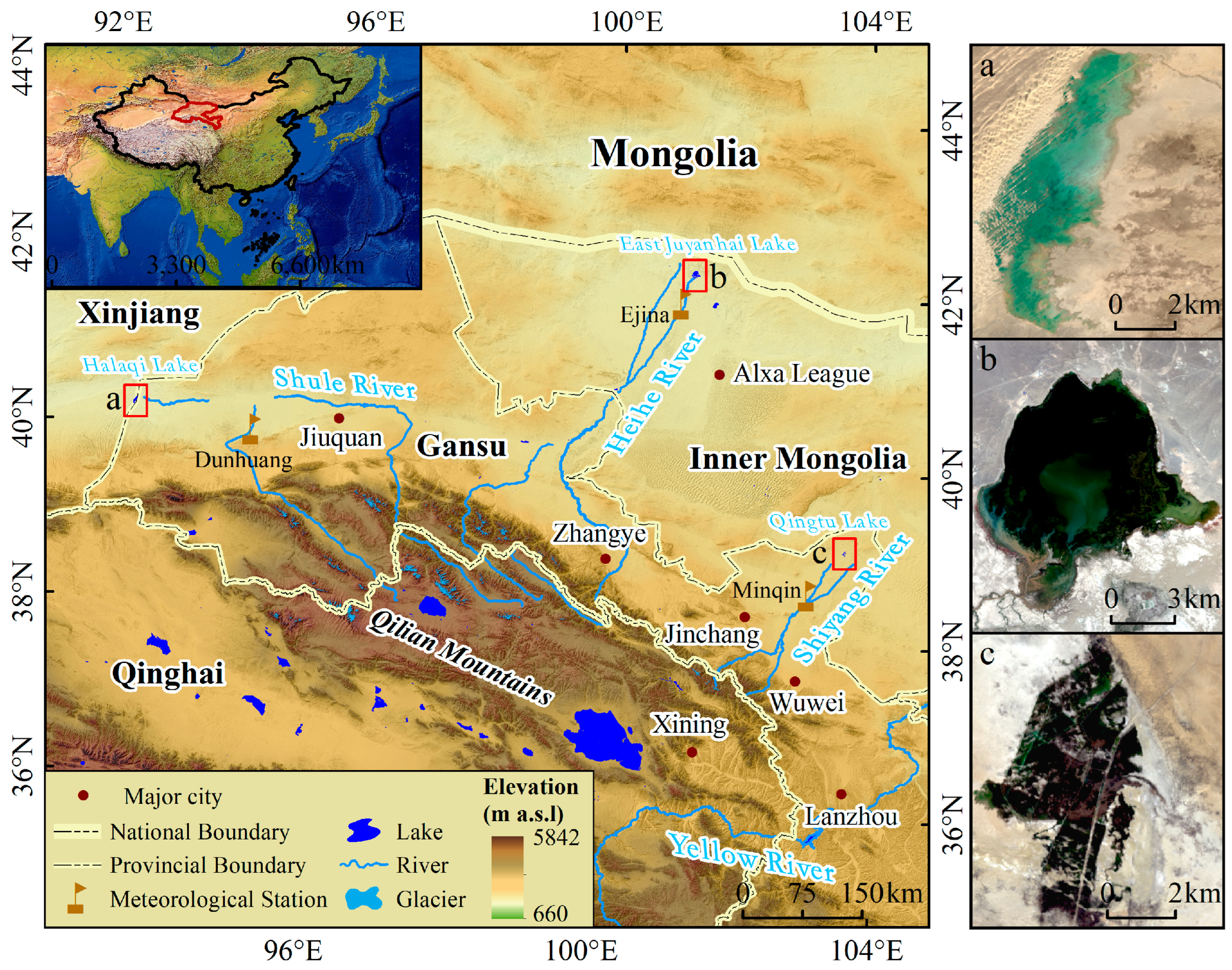
2. Study Area
3. Data and Methods
3.1. Data Sources
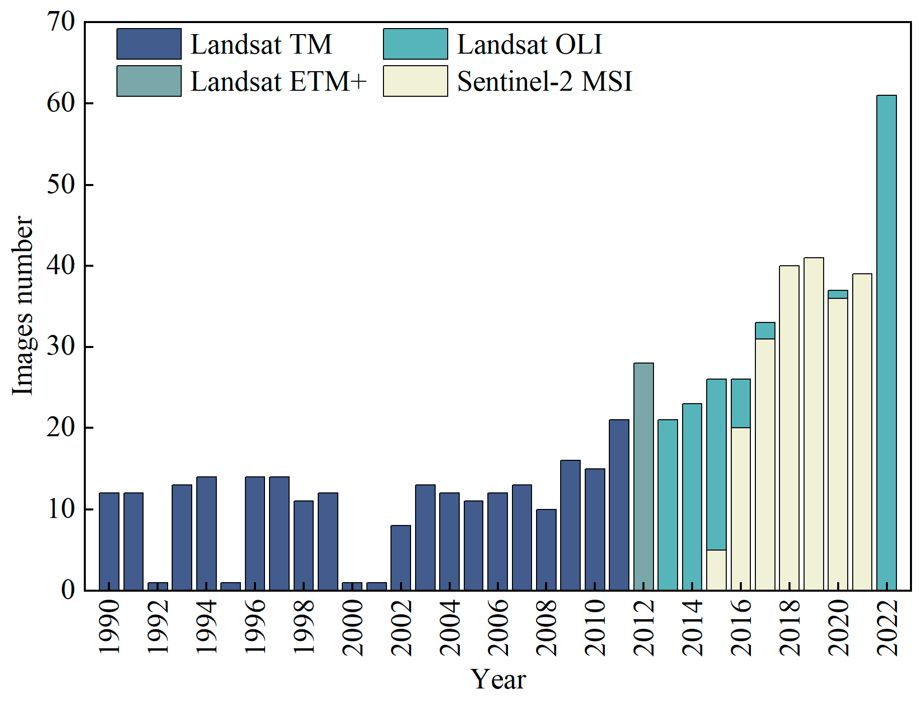
3.1.1. Landsat and Sentinel Series Images
3.1.2. Meteorological Data
3.1.3. Water Resource Consumption Data
3.2. Method
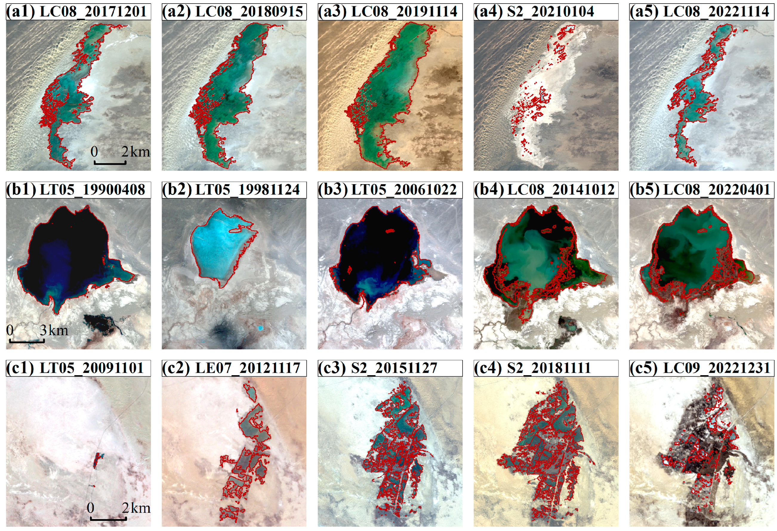
3.2.1. Extraction of Lake Information
3.2.2. Calculation of Potential Evapotranspiration
4. Results
4.1. Inter-Annual Change
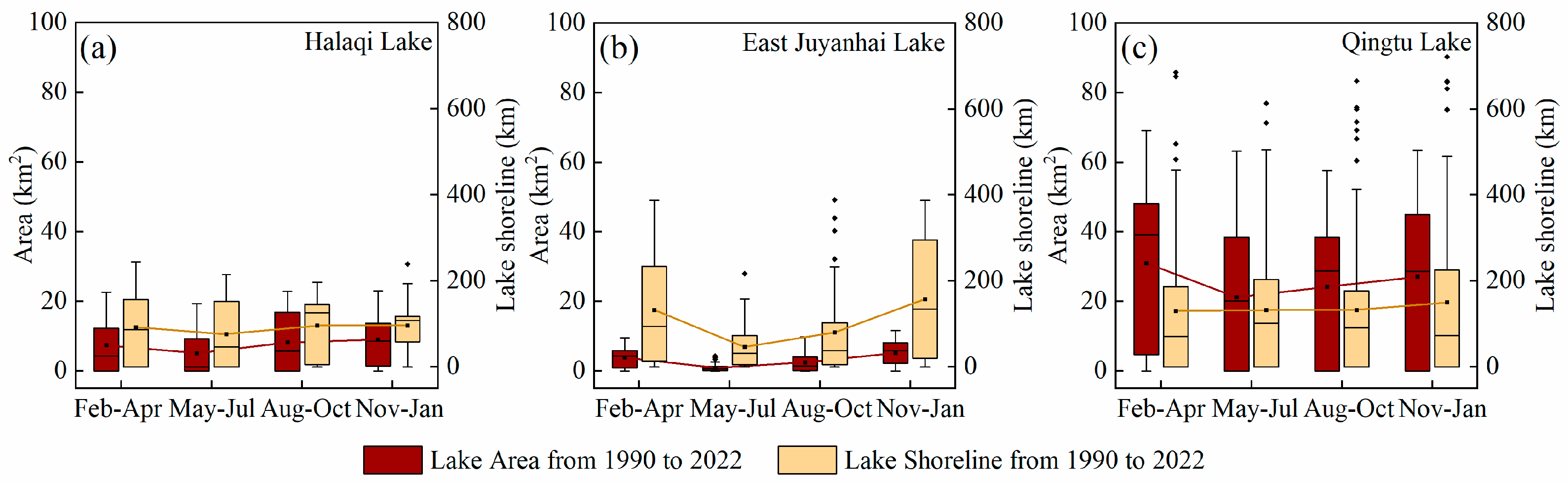
4.2. Intra-Annual Change
5. Discussion
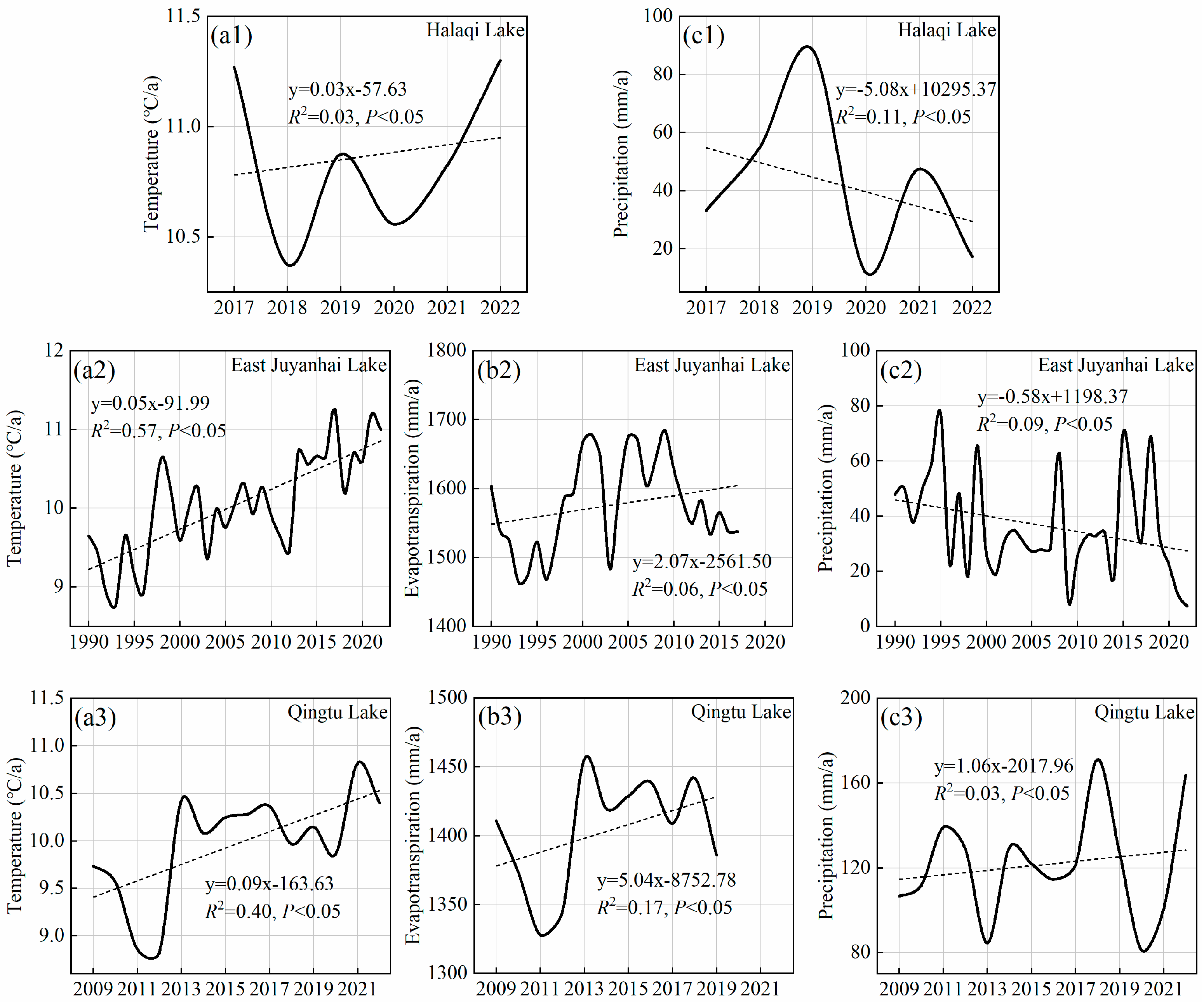
5.1. Response of Lakes to Climate Change
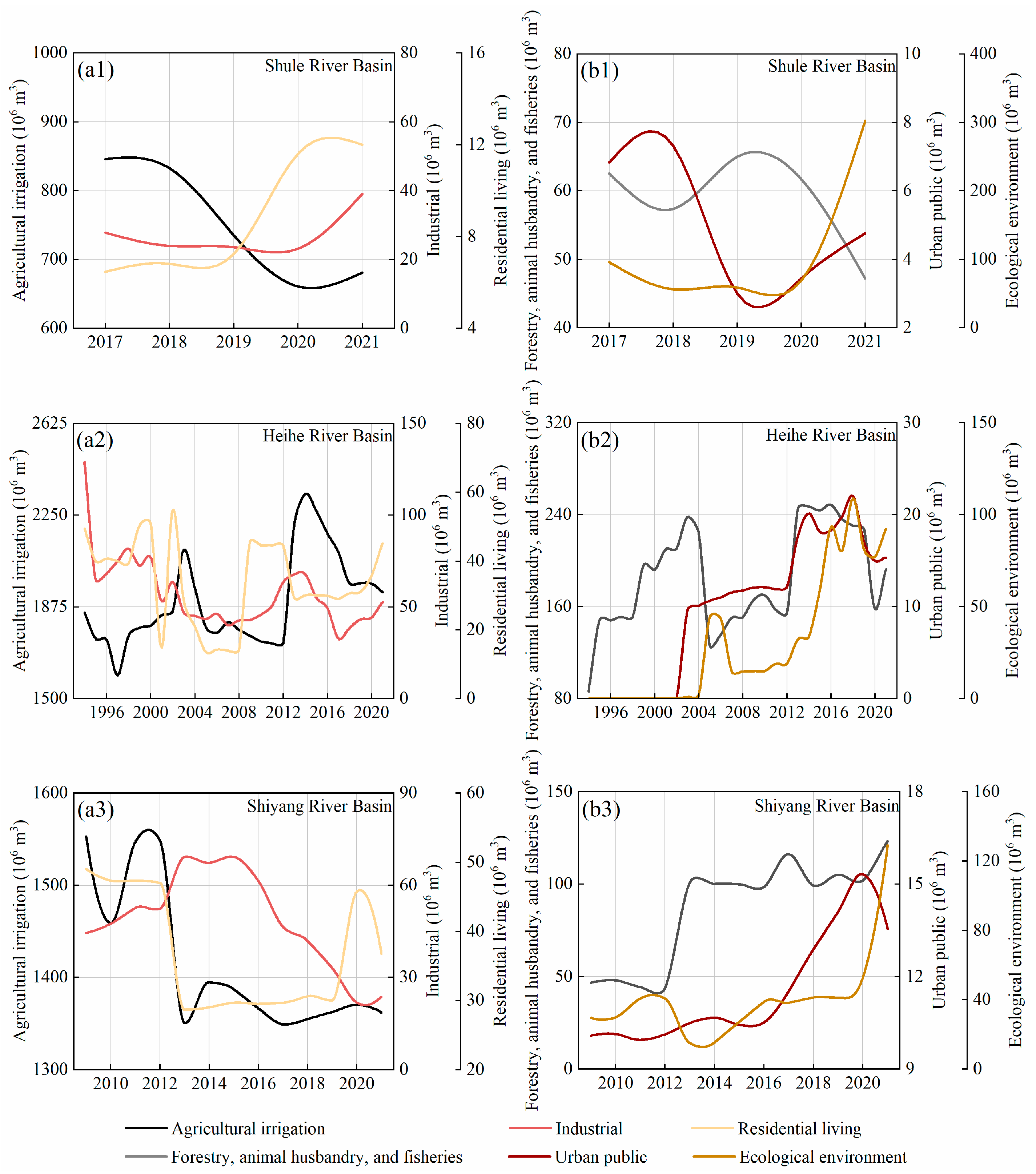
5.2. Impact of Human Activities on Lake Area
6. Conclusions
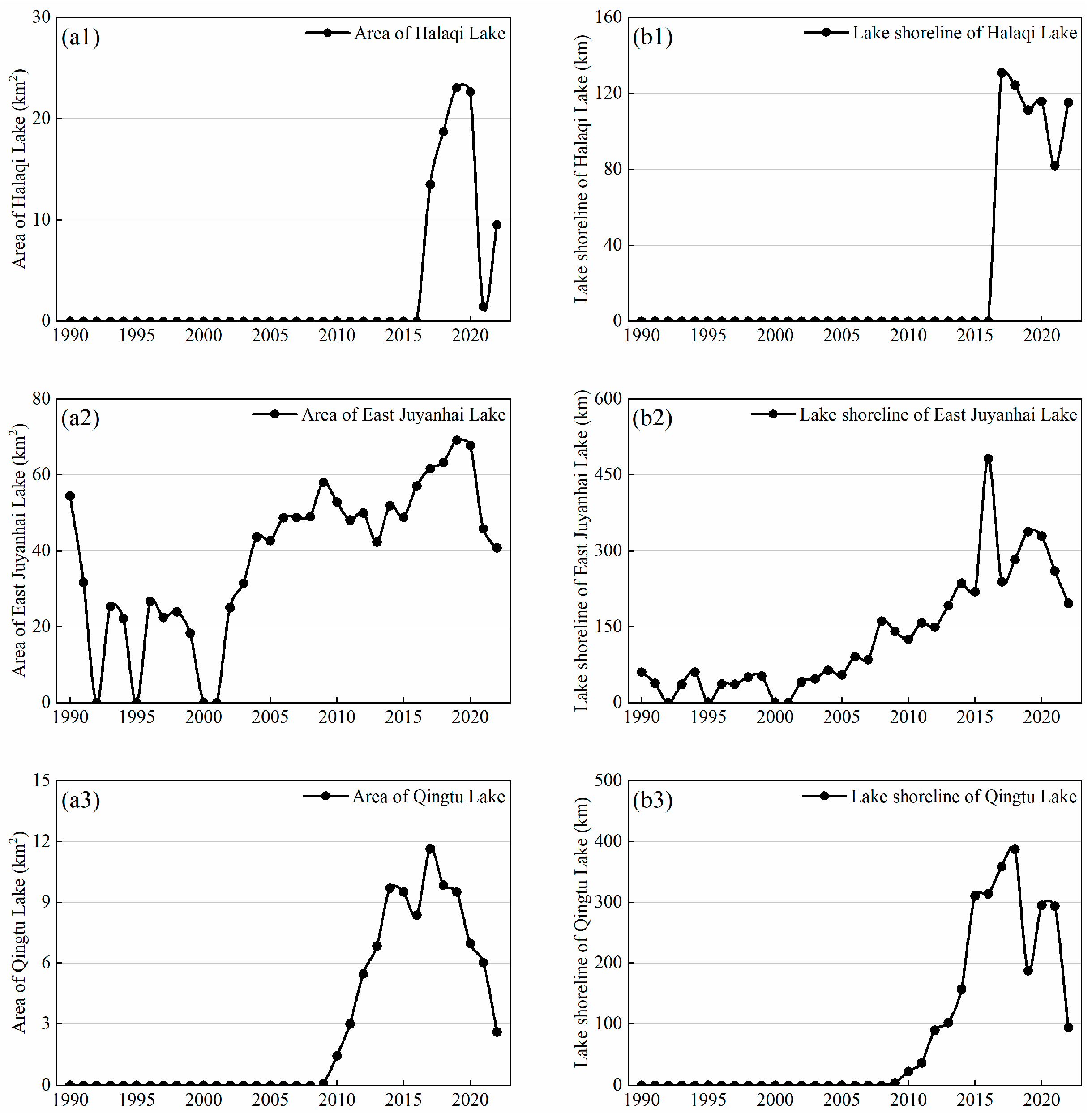
- Since 1990, the surface areas of Halaqi Lake, East Juyanhai Lake, and Qingtu Lake have experienced dynamic shifts such as drying, expansion, and contraction. Among them, Halaqi Lake formed a water surface area of 13.49 km2 in 2017, attained its peak extent of 23.03 km2 in 2019, and was subsequently reduced to 9.53 km2 by 2022. East Juyanhai Lake encountered dry conditions in the years 1992, 1995, 2001, and 2002. Subsequently, the lake underwent rapid expansion, achieving its peak area of 69.09 km2 in 2019. Nevertheless, by 2022, the lake’s area had declined to 40.84 km2. In 2009, Qingtu Lake’s area expanded from 0.00 km2 to 0.09 km2. It reached its maximum extent in 2017 (11.63 km2). However, from 2017 to 2022, the lake’s area steadily decreased, with Qingtu Lake’s water surface area diminishing to 2.60 km2 by 2022;
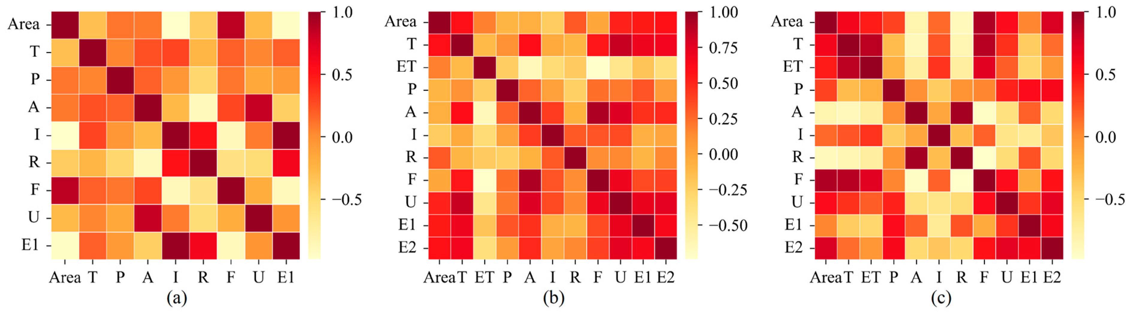
- The area of the lakes primarily results from the combined influences of climate change and human activities. East Juyanhai Lake’s area is notably more affected by climate change, while Halaqi Lake and Qingtu Lake are more impacted by human activities. Among these lakes, the most prominent factors influencing area changes are industrial water consumption (0.98) for Halaqi Lake, temperature (0.6) for East Juyanhai Lake, and water consumption for forestry, animal husbandry, and fisheries (0.91) for Qingtu Lake. The varying geographical locations led to significant disparities in the correlation between climate and human activities affecting the area of these three lakes. Nonetheless, it is essential to note that the management of water resources through human activities stands as the primary cause of sudden area changes in these lakes;
- Terminal lakes depend on residual water from upstream usage and often do not receive adequate priority. Therefore, the fundamental approach to the ecological restoration of terminal lakes is the release of ecological water. The amount of water released each year needs to be adjusted based on dynamic meteorological conditions and the lake’s water budget. Different lake management goals and related environmental water requirements should be established under three different meteorological conditions: wet years, normal years, and dry years. This also involves considering the evapotranspiration of natural vegetation, the evaporation from the basin, and the seepage from lakes and rivers. While these actions have been proven beneficial in the short term, further measures, such as improving the efficiency of agricultural irrigation, increasing the reuse of industrial water, and expanding wastewater treatment and reuse can help reduce upstream water withdrawals for production and domestic use. This will play a significant role in improving the local ecology.
Author Contributions
Funding
Institutional Review Board Statement
Informed Consent Statement
Data Availability Statement
Acknowledgments
Conflicts of Interest
References
- Hu, R.; Jiang, F.; Wang, Y.; Sun, Z.; Li, Y. On the importance of research on the lakes in arid land of China. Arid Zone Res. 2007, 24, 137–140. [Google Scholar]
- Cooper, J.J.; Koch, D.L. Limnology of a desertic terminal lake, Walker Lake, Nevada, USA. Hydrobiologia 1984, 118, 275–292. [Google Scholar] [CrossRef]
- Wang, S.; Dou, H. Lake Records of China; Science Press: Beijing, China, 1998. [Google Scholar]
- Niswonger, R.G.; Allander, K.K.; Jeton, A.E. Collaborative modelling and integrated decision support system analysis of a developed terminal lake basin. J. Hydrol. 2014, 517, 521–537. [Google Scholar] [CrossRef]
- Bai, J.; Chen, X.; Li, J.; Yang, L. Changes of inland lake area in arid Central Asia during 1975–2007: A remote-sensing analysis. J. Lake Sci. 2011, 23, 80–88. [Google Scholar]
- Liu, H.; Chen, Y.; Ye, Z.; Li, Y.; Zhang, Q. Recent Lake Area Changes in Central Asia. Sci. Rep. 2019, 9, 16277. [Google Scholar] [CrossRef] [PubMed]
- Cheng, G.; Li, X.; Zhao, W.; Xu, Z.; Feng, Q.; Xiao, S.; Xiao, H. Integrated study of the water-ecosystem-economy in the Heihe River Basin. Nat. Sci. Rev. 2014, 1, 413–428. [Google Scholar] [CrossRef]
- Wang, G.; Cheng, G.; Xu, Z. The utilization of water resource and its influence on eco-environment in the northwest arid area of China. J. Nat. Resour. 1999, 14, 109–116. [Google Scholar]
- Zhang, A.; Zheng, C.; Wang, S.; Yao, Y. Analysis of streamflow variations in the Heihe River Basin, northwest China: Trends, abrupt changes, driving factors and ecological influences. J. Hydrol. Reg. Stud. 2015, 3, 106–124. [Google Scholar] [CrossRef]
- Torabi Haghighi, A.; Kløve, B. Design of environmental flow regimes to maintain lakes and wetlands in regions with high seasonal irrigation demand. Ecol. Eng. 2017, 100, 120–129. [Google Scholar] [CrossRef]
- Fang, L.; Tao, S.; Zhu, J.; Liu, Y. Impacts of climate change and irrigation on lakes in arid northwest China. J. Arid Environ. 2018, 154, 34–39. [Google Scholar] [CrossRef]
- Tao, S.; Fang, J.; Zhao, X.; Zhao, S.; Shen, H.; Hu, H.; Tang, Z.; Wang, Z.; Guo, Q. Rapid loss of lakes on the Mongolian Plateau. Proc. Natl. Acad. Sci. USA 2015, 112, 2281–2286. [Google Scholar] [CrossRef] [PubMed]
- Torabi Haghighi, A.; Fazel, N.; Hekmatzadeh, A.A.; Klöve, B. Analysis of Effective Environmental Flow Release Strategies for Lake Urmia Restoration. Water Resour. Manag. 2018, 32, 3595–3609. [Google Scholar] [CrossRef]
- Zhang, L.; Nan, Z.; Xu, Y.; Li, S. Hydrological impacts of land use change and climate variability in the headwater region of the Heihe River Basin, Northwest China. PLoS ONE 2016, 11, e0158394. [Google Scholar] [CrossRef] [PubMed]
- Fang, C.; Bao, C.; Huang, J. Management Implications to Water Resources Constraint Force on Socio-economic System in Rapid Urbanization: A Case Study of the Hexi Corridor, NW China. Water Resour. Manag. 2006, 21, 1613–1633. [Google Scholar] [CrossRef]
- Vorosmarty, C.J.; Green, P.; Salisbury, J.; Lammers, R.B. Global water resources: Vulnerability from climate change and population growth. Science 2000, 289, 284–288. [Google Scholar] [CrossRef] [PubMed]
- He, X.; Zhang, B.; Sun, L.; Jin, S.; Zhao, Y.; An, M. Contribution rates of climate change and human activity on the runoff in upper and middle reaches of Heihe River Basin. Chin. J. Ecol. 2012, 31, 2884. [Google Scholar]
- Zhang, M.; Wang, S.; Fu, B.; Gao, G.; Shen, Q. Ecological effects and potential risks of the water diversion project in the Heihe River Basin. Sci. Total Environ. 2018, 619–620, 794–803. [Google Scholar] [CrossRef]
- Zhou, J.; Lei, L.; Shi, P.; Wang, L.; Wei, W.; Liu, H. Response of runoff to the climate and land use pattern changes in Shiyang River Basin. Acta Ecol. Sin. 2015, 35, 3788–3796. [Google Scholar]
- Chunyu, X.; Huang, F.; Xia, Z.; Zhang, D.; Chen, X.; Xie, Y. Assessing the Ecological Effects of Water Transport to a Lake in Arid Regions: A Case Study of Qingtu Lake in Shiyang River Basin, Northwest China. Int. J. Environ. Res. Public Health 2019, 16, 145. [Google Scholar] [CrossRef]
- Bao, C.; Fang, C. Water resources constraint force on urbanization in water deficient regions: A case study of the Hexi Corridor, arid area of NW China. Ecol. Econ. 2007, 62, 508–517. [Google Scholar] [CrossRef]
- Zhang, Y.; Fu, G.; Sun, B.; Zhang, S.; Men, B. Simulation and classification of the impacts of projected climate change on flow regimes in the arid Hexi Corridor of Northwest China. J. Geophys. Res. Atmos. 2015, 120, 7429–7453. [Google Scholar] [CrossRef]
- Guan, X.; Qi, X.; Wu, Z. Analysis on energy value of service function of East Juyan Lake Wetland ecosystem. Res. Soil Water Conserv. 2012, 19, 253–261. [Google Scholar]
- Zhang, Y. Effects of eco-water transfer on changes of vegetation in the lower Heihe River Basin. J. Hydraul. Eng. 2011, 42, 757–765. [Google Scholar]
- Zhao, Q.; Wang, N.; Cheng, H.; Kan, Y.; Guo, J. Grain-size characteristics of Qingtu Lake sediments and its paleaoenvironment explaination. Arid Land Geogr. 2003, 26, 1–5. [Google Scholar]
- Duan, Z.; Afzal, M.; Liu, X.; Chen, S.; Du, R.; Zhao, B.; Yuan, W.; Awais, M. Effects of climate change and human activities on environment and area variations of the Aral Sea in Central Asia. Int. J. Environ. Sci. Technol. 2023, 1–14. [Google Scholar] [CrossRef]
- Yıldırım, Ü.; Erdoğan, S.; Uysal, M. Changes in the coastline and water level of the Akşehir and Eber Lakes between 1975 and 2009. Water Resour. Manag. 2011, 25, 941–962. [Google Scholar] [CrossRef]
- Zhang, Y.; Wang, N.; Yang, X.; Mao, Z. The Dynamic Changes of Lake Issyk-Kul from 1958 to 2020 Based on Multi-Source Satellite Data. Remote Sens. 2022, 14, 1575. [Google Scholar] [CrossRef]
- Huang, F.; Chunyu, X.; Zhang, D.; Chen, X.; Ochoa, C.G. A framework to assess the impact of ecological water conveyance on groundwater-dependent terrestrial ecosystems in arid inland river basins. Sci. Total Environ. 2020, 709, 136155. [Google Scholar] [CrossRef]
- Zhou, Y.; Li, X.; Yang, K.; Zhou, J. Assessing the impacts of an ecological water diversion project on water consumption through high-resolution estimations of actual evapotranspiration in the downstream regions of the Heihe River Basin, China. Agric. For. Meteorol. 2018, 249, 210–227. [Google Scholar] [CrossRef]
- McFeeters, S.K. The use of the Normalized Difference Water Index (NDWI) in the delineation of open water features. Int. J. Remote Sens. 2007, 17, 1425–1432. [Google Scholar] [CrossRef]
- Zack, G.W.; Rogers, W.E.; Latt, S.A. Automatic measurement of sister chromatid exchange frequency. J. Histochem. Cytochem. 1977, 25, 741–753. [Google Scholar] [CrossRef] [PubMed]
- Penman, H. Evaporation: An introductory survey. Neth. J. Agric. Sci. 1956, 4, 9–29. [Google Scholar] [CrossRef]
- Huang, S.; Feng, Q.; Lu, Z.; Wen, X.; Deo, R. Trend Analysis of Water Poverty Index for Assessment of Water Stress and Water Management Polices: A Case Study in the Hexi Corridor, China. Sustainability 2017, 9, 756. [Google Scholar] [CrossRef]
- Zhang, G.; Yao, T.; Xie, H.; Wang, W.; Yang, W. An inventory of glacial lakes in the Third Pole region and their changes in response to global warming. Glob. Planet. Chang. 2015, 131, 148–157. [Google Scholar] [CrossRef]
- Gooseff, M.N.; McKnight, D.M.; Doran, P.T.; Fountain, A. Long-term stream hydrology and meteorology of a Polar Desert, the McMurdo Dry Valleys, Antarctica. Hydrol. Process. 2022, 36, e14623. [Google Scholar] [CrossRef]
- Gao, X.; Zhang, S.; Ye, B.; Gao, H. Recent changes of glacier runoff in the Hexi Inland river basin. Adv. Water Sci. 2011, 22, 344–350. [Google Scholar]
- Liu, S.; Shen, Y.; Sun, W.; Li, G. Glacier variation since the maximum of the Little Ice Age in the western Qilian Mountains, northwest China. J. Glaciol. Geocryol. 2002, 24, 227–233. [Google Scholar]
- Sun, M.; Liu, S.; Yao, X.; Guo, W.; Xu, J. Glacier changes in the Qilian Mountains in the past half-century: Based on the revised First and Second Chinese Glacier Inventory. J. Geogr. Sci. 2018, 28, 206–220. [Google Scholar] [CrossRef]
- Woolway, R.I.; Kraemer, B.M.; Lenters, J.D.; Merchant, C.J.; O’Reilly, C.M.; Sharma, S. Global lake responses to climate change. Nat. Rev. Earth Environ. 2020, 1, 388–403. [Google Scholar] [CrossRef]
- Wang, Y.; Qin, D. Influence of climate change and human activity on water resources in arid region of Northwest China: An overview. Adv. Clim. Chang. Res. 2017, 8, 268–278. [Google Scholar] [CrossRef]
- Ji, X.; Kang, E.; Chen, R.; Zhao, W.; Zhang, Z.; Jin, B. The impact of the development of water resources on environment in arid inland river basins of Hexi region, Northwestern China. Environ. Geol. 2006, 50, 793–801. [Google Scholar] [CrossRef]
- Wang, X.; Ding, Y.; Wang, J.; Zhao, C. Spatio-temporal variation characteristics of precipitation in the Hexi region during 1960–2017. J. Glaciol. Geocryol. 2021, 43, 1179–1189. [Google Scholar]
- Schulz, S.; Darehshouri, S.; Hassanzadeh, E.; Tajrishy, M.; Schüth, C. Climate change or irrigated agriculture–what drives the water level decline of Lake Urmia. Sci. Rep. 2020, 10, 236. [Google Scholar] [CrossRef] [PubMed]
- Mozafari, M.; Hosseini, Z.; Fijani, E.; Eskandari, R.; Siahpoush, S.; Ghader, F. Effects of climate change and human activity on lake drying in Bakhtegan Basin, southwest Iran. Sustain. Water Resour. Manag. 2022, 8, 109. [Google Scholar] [CrossRef]
- Yuan, Y.; Zeng, G.; Liang, J.; Huang, L.; Hua, S.; Li, F.; Zhu, Y.; Wu, H.; Liu, J.; He, X. Variation of water level in Dongting Lake over a 50-year period: Implications for the impacts of anthropogenic and climatic factors. J. Hydrol. 2015, 525, 450–456. [Google Scholar] [CrossRef]
- Wada, Y.; Van Beek, L.P.; Wanders, N.; Bierkens, M.F. Human water consumption intensifies hydrological drought worldwide. Environ. Res. Lett. 2013, 8, 034036. [Google Scholar] [CrossRef]
- Yang, X.; Lu, X. Drastic change in China’s lakes and reservoirs over the past decades. Sci. Rep. 2014, 4, 6041. [Google Scholar] [CrossRef]
- Guo, Q.; Feng, Q.; Li, J. Environmental changes after ecological water conveyance in the lower reaches of Heihe River, northwest China. Environ. Geol. 2008, 58, 1387–1396. [Google Scholar] [CrossRef]
- Zhu, Y.; Chen, Y.; Ren, L.; Lü, H.; Zhao, W.; Yuan, F.; Xu, M. Ecosystem restoration and conservation in the arid inland river basins of Northwest China: Problems and strategies. Ecol. Eng. 2016, 94, 629–637. [Google Scholar] [CrossRef]
- Kang, E. Water resources relating to desertification in the Hexi area of Gansu Province, China. J. Glaciol. Geocryol. 2004, 26, 657–667. [Google Scholar]
- Hu, S.; Ma, R.; Sun, Z.; Ge, M.; Zeng, L.; Huang, F.; Bu, J.; Wang, Z. Determination of the optimal ecological water conveyance volume for vegetation restoration in an arid inland river basin, northwestern China. Sci. Total Environ. 2021, 788, 147775. [Google Scholar] [CrossRef] [PubMed]
- Xi, H.; Feng, Q.; Si, J.; Chang, Z.; Cao, S. Impacts of river recharge on groundwater level and hydrochemistry in the lower reaches of Heihe River Watershed, northwestern China. Hydrogeol. J. 2009, 18, 791–801. [Google Scholar] [CrossRef]
- Shi, Y.; Shen, Y.; Hu, R. Preliminary study on signal, impact and foreground of climatic shift from warm-dry to warm-humid in Northwest China. J. Glaciol. Geocryol. 2002, 24, 219–226. [Google Scholar]
- Dou, X.; Ma, X.; Huo, T.; Zhu, J.; Zhao, C. Assessment of the environmental effects of ecological water conveyance over 31 years for a terminal lake in Central Asia. Catena 2022, 208, 105725. [Google Scholar] [CrossRef]
- Dong, Z.; Xu, X.; Jin, H.; Liu, S.; Zhang, J.; Tang, W.; Chai, C.; Zhao, P.; Wang, X. The impact of eco-water transportation to the vegetation in tail lake of Shiyang River. J. Arid Land Resour. Environ. 2015, 7, 101–106. [Google Scholar]
- Ren, J.; Xiao, H.; Wang, Y.; Xiao, S. Valuation of ecosystem service values of Juyan Lake wetland. J. Desert Res. 2012, 32, 852–856. [Google Scholar]


Disclaimer/Publisher’s Note: The statements, opinions and data contained in all publications are solely those of the individual author(s) and contributor(s) and not of MDPI and/or the editor(s). MDPI and/or the editor(s) disclaim responsibility for any injury to people or property resulting from any ideas, methods, instructions or products referred to in the content. |
© 2023 by the authors. Licensee MDPI, Basel, Switzerland. This article is an open access article distributed under the terms and conditions of the Creative Commons Attribution (CC BY) license (https://creativecommons.org/licenses/by/4.0/).
Share and Cite
Ma, Q.; Yao, X.; Zhang, C.; Yang, C.; Yang, K.; Tian, Z.; Li, J. Spatio-Temporal Dynamics of Terminal Lakes in the Hexi Interior, China. Sustainability 2024, 16, 211. https://doi.org/10.3390/su16010211
Ma Q, Yao X, Zhang C, Yang C, Yang K, Tian Z, Li J. Spatio-Temporal Dynamics of Terminal Lakes in the Hexi Interior, China. Sustainability. 2024; 16(1):211. https://doi.org/10.3390/su16010211
Chicago/Turabian StyleMa, Qin, Xiaojun Yao, Cong Zhang, Chen Yang, Kang Yang, Zhijuan Tian, and Jiawei Li. 2024. "Spatio-Temporal Dynamics of Terminal Lakes in the Hexi Interior, China" Sustainability 16, no. 1: 211. https://doi.org/10.3390/su16010211