
Assessment of Environmentally Minimum Water Level in a Mediterranean Lake Using Morphological, Hydrological and Biological Factors

 , ,
, ,
Abstract
:1. Introduction
2. Materials and Methods
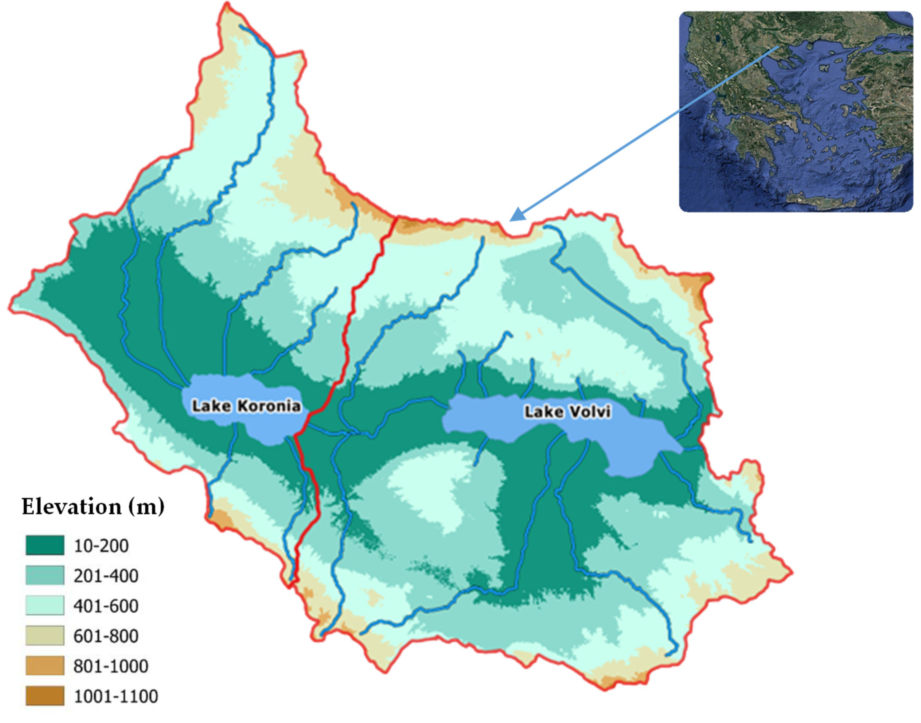
2.1. Study Area
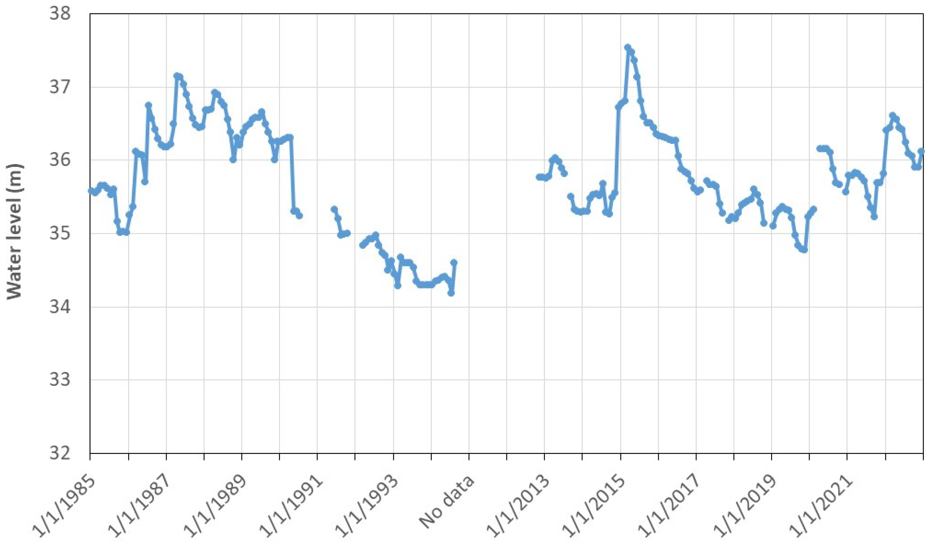
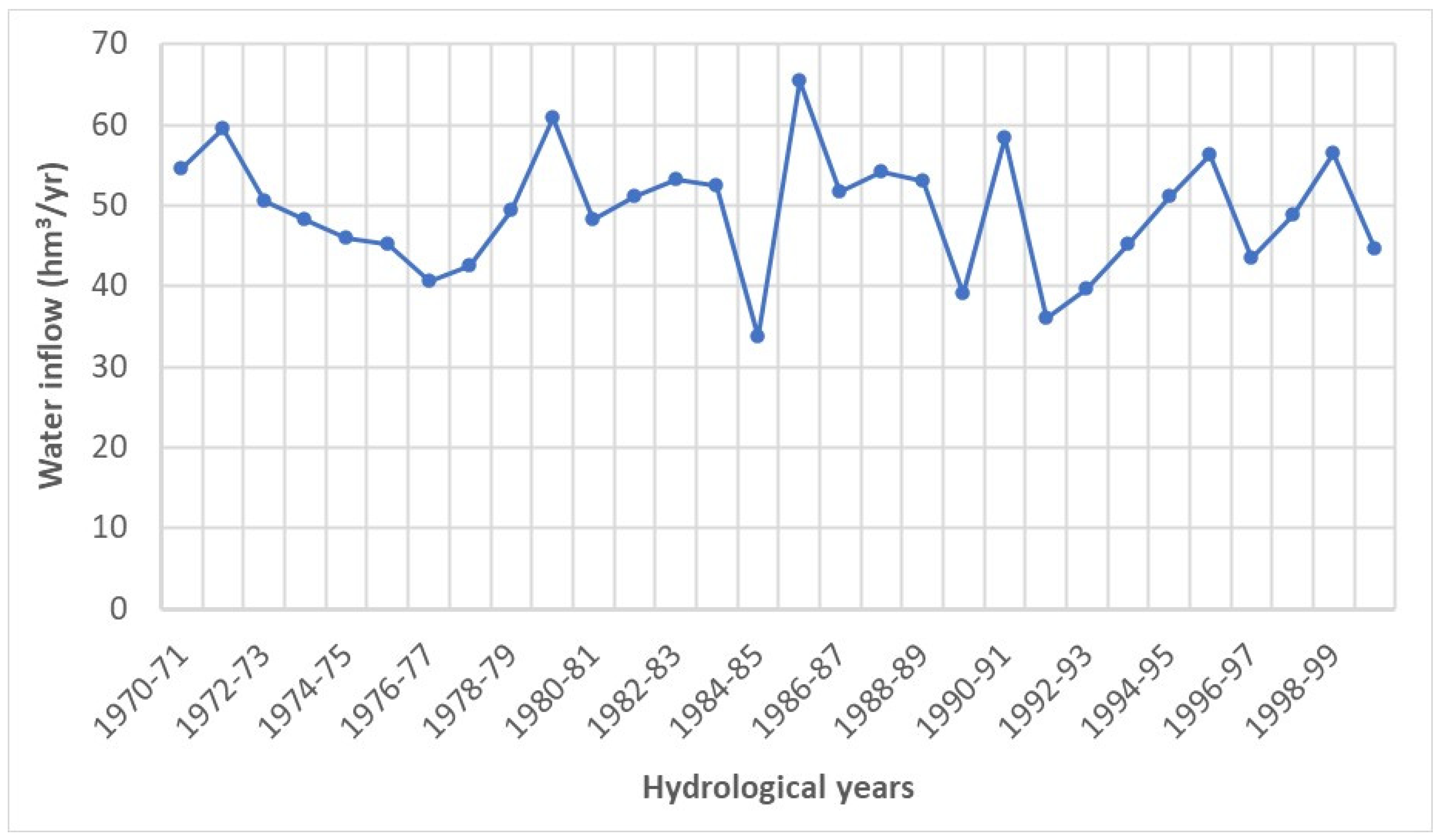
2.2. Datasets
2.3. Hydromorphological Analysis
2.3.1. Morphological Method
2.3.2. Hydromorphological Method
2.4. Habitat Types and Lake Bottom Granulometry
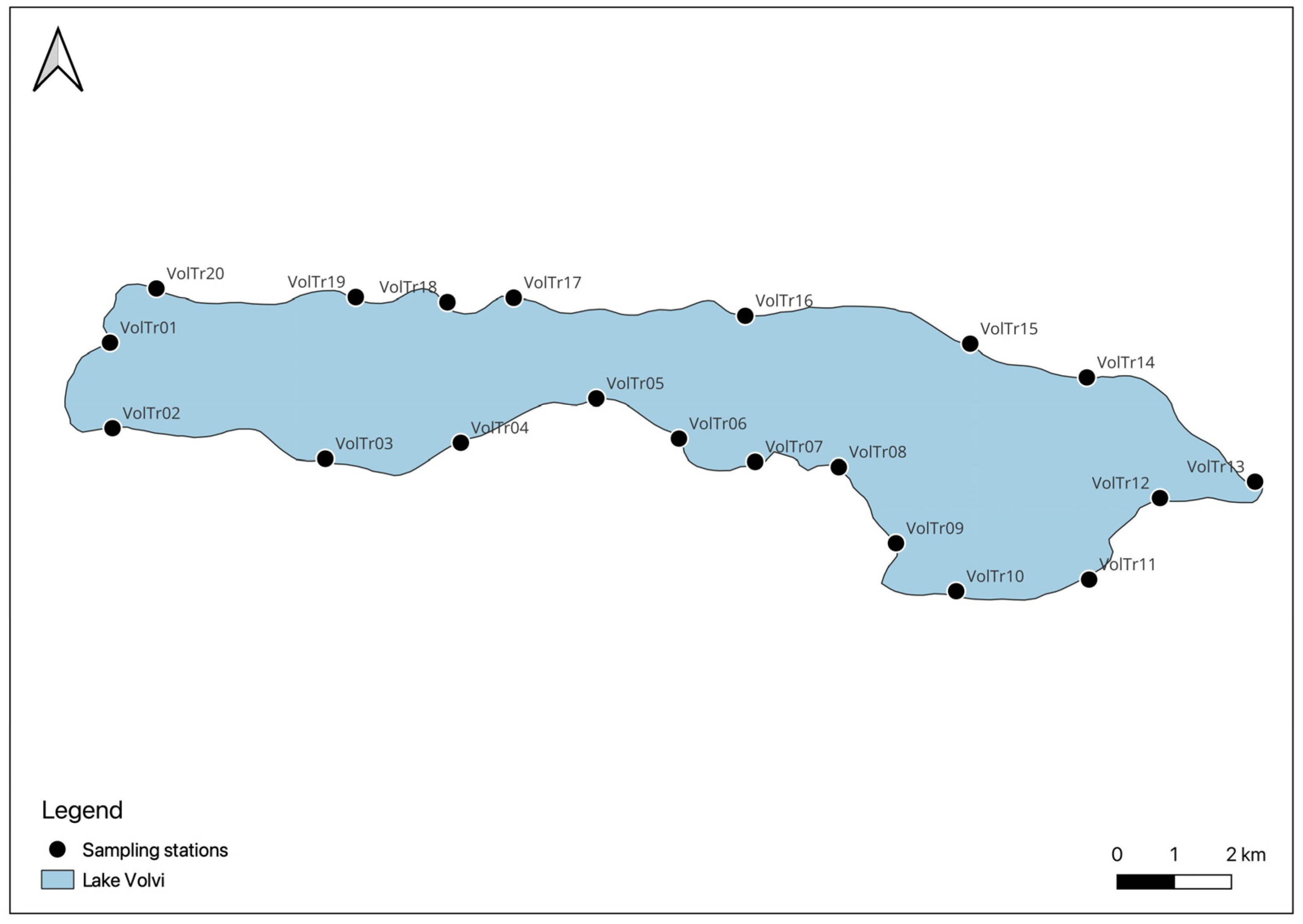
2.5. Biological Elements
2.5.1. Macrophytes
2.5.2. Benthic Macroinvertebrates
2.5.3. Fish Fauna
3. Results
3.1. Minimum Lake Level Based on Hydromorphological Analysis
3.2. Water Level Requirements of Biological Elements
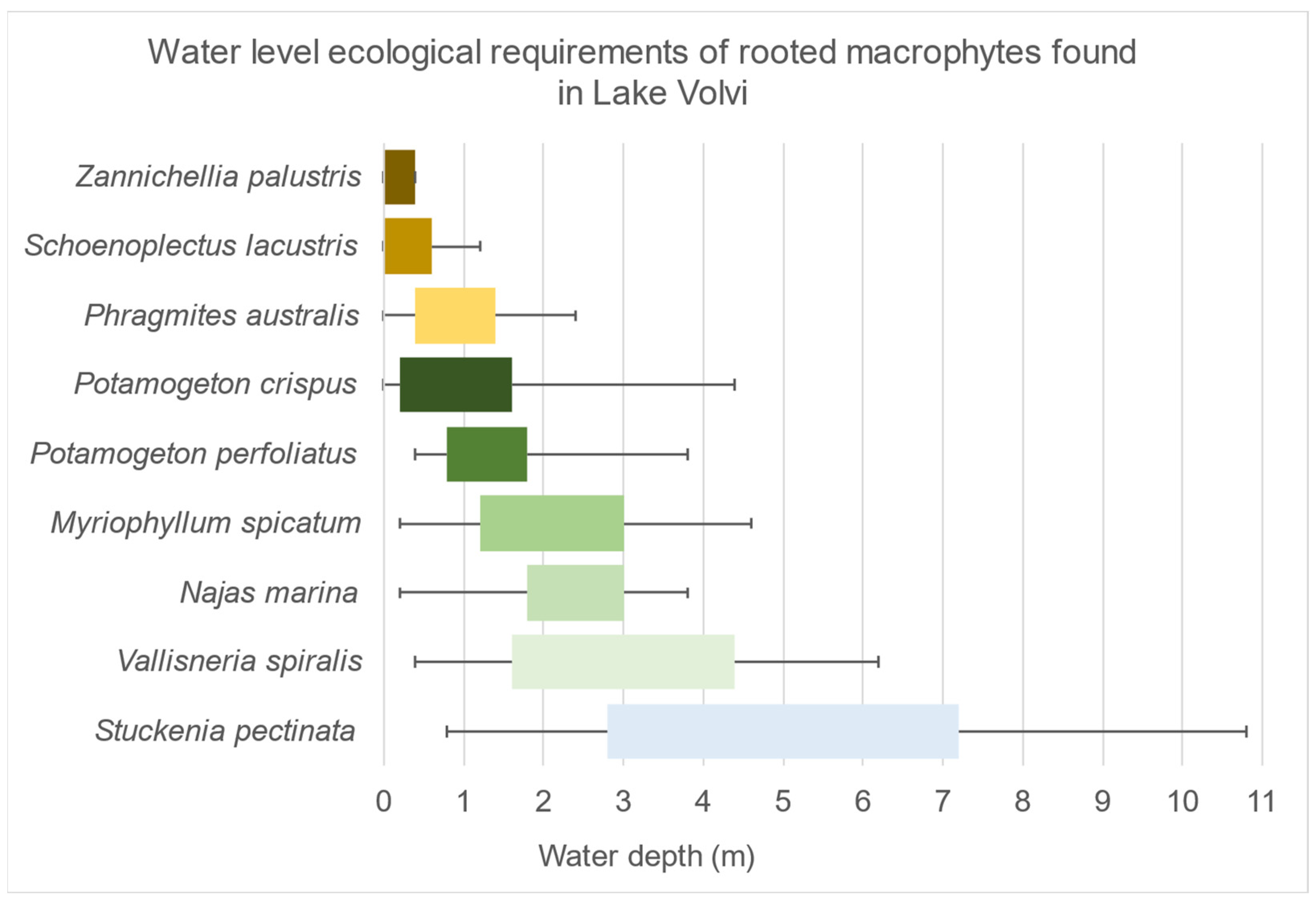
3.2.1. Macrophytes
3.2.2. Benthic Macroinvertebrates
3.2.3. Fish Fauna
4. Discussion
5. Conclusions
Supplementary Materials
Author Contributions
Funding
Institutional Review Board Statement
Informed Consent Statement
Data Availability Statement
Acknowledgments
Conflicts of Interest
References
- Shang, S. Lake Surface Area Method to Define Minimum Ecological Lake Level from Level-Area-Storage Curves. J. Arid Land 2013, 5, 133–142. [Google Scholar] [CrossRef]
- Li, X.; Song, Y.; Li, Y.; Xing, X.; Zhang, S. Calculation Methods of Lowest Ecological Water Level of Lake. Arid Land Geogr. 2007, 30, 526–530. [Google Scholar]
- Shang, S.; Shang, S. Simplified Lake Surface Area Method for the Minimum Ecological Water Level of Lakes and Wetlands. Water 2018, 10, 1056. [Google Scholar] [CrossRef]
- Xu, Z.; Chen, M.; Dong, Z. Researches on the Calculation Methods of the Lowest Ecological Water Level of Lake. Acta Ecol. Sin. 2004, 24, 2324–2328. [Google Scholar]
- Leeper, D.; Ellison, D. Proposed Minimum and Guidance Levels for Lake Hancock in Polk County, Florida; Southwest Florida Water Management District: Brooksville, FL, USA, 2015. [Google Scholar]
- Wen, D.; Jin, C.; Shixiang, G.; Gang, C.; Jinming, C.; Mi, Z. Hydrological Variability of Water Level of Dianchi Lake and Its Application. IOP Conf. Ser. Mater. Sci. Eng. 2020, 780, 062048. [Google Scholar] [CrossRef]
- Doulgeris, C.; Koukouli, P.; Georgiou, P.; Dalampakis, P.; Karpouzos, D. Assessment of Minimum Water Level in Lakes and Reservoirs Based on Their Morphological and Hydrological Features. Hydrology 2020, 7, 83. [Google Scholar] [CrossRef]
- Cui, B.; Tang, N.; Zhao, X.; Bai, J. A Management-Oriented Valuation Method to Determine Ecological Water Requirement for Wetlands in the Yellow River Delta of China. J. Nat. Conserv. 2009, 17, 129–141. [Google Scholar] [CrossRef]
- Abbaspour, M.; Nazaridoust, A. Determination of Environmental Water Requirements of Lake Urmia, Iran: An Ecological Approach. Int. J. Environ. Stud. 2007, 64, 161–169. [Google Scholar] [CrossRef]
- Mjelde, M.; Hellsten, S.; Ecke, F. A Water Level Drawdown Index for Aquatic Macrophytes in Nordic Lakes. Hydrobiologia 2013, 704, 141–151. [Google Scholar] [CrossRef]
- Yi, Y.; Xie, H.; Yang, Y.; Zhou, Y.; Yang, Z. Suitable Habitat Mathematical Model of Common Reed (Phragmites australis) in Shallow Lakes with Coupling Cellular Automaton and Modified Logistic Function. Ecol. Model. 2020, 419, 108938. [Google Scholar] [CrossRef]
- Yang, W.; Xu, M.; Li, R.; Zhang, L.; Deng, Q. Estimating the Ecological Water Levels of Shallow Lakes: A Case Study in Tangxun Lake, China. Sci. Rep. 2020, 10, 5637. [Google Scholar] [CrossRef]
- Wang, L.; Li, Z.; Liu, C.; Wang, S.; Li, B.; Liu, X.; Han, Z. Research on Ecological Water Level of Open Lakes: A Case Study of Poyang Lake. In Proceedings of the 2020 5th International Conference on Smart Grid and Electrical Automation (ICSGEA), Zhangjiajie, China, 13–14 June 2020; pp. 606–610. [Google Scholar]
- Bao, K.; Liu, J.; Meng, B.; Sun, B. The Effects of Hydrological Conditions on Eco-Exergy of Food Webs in Momoge National Nature Reserve, China. Wetlands 2019, 39, 601–617. [Google Scholar] [CrossRef]
- Robel, R.J. Changes in Submersed Vegetation Following a Change in Water Level. J. Wildl. Manag. 1962, 26, 221–224. [Google Scholar] [CrossRef]
- Keddy, P.A.; Reznicek, A.A. Vegetation Dynamics, Buried Seeds, and Water Level Fluctuations on the Shorelines of the Great Lakes. In Coastal Wetlands; Prince, H.H., D’Itri, F.M., Eds.; CRC Press: Boca Raton, FL, USA, 1985; pp. 33–58. ISBN 978-1-351-07072-0. [Google Scholar]
- Van Der Valk, A.G.; Squires, L.; Welling, C.H. Assessing the Impacts of an Increase in Water Level on Wetland Vegetation. Ecol. Appl. 1994, 4, 525–534. [Google Scholar] [CrossRef]
- Coops, H.; Vulink, J.T.; Van Nes, E.H. Managed Water Levels and the Expansion of Emergent Vegetation along a Lakeshore. Limnologica 2004, 34, 57–64. [Google Scholar] [CrossRef]
- Riis, T.; Hawes, I. Relationships between Water Level Fluctuations and Vegetation Diversity in Shallow Water of New Zealand Lakes. Aquat. Bot. 2002, 74, 133–148. [Google Scholar] [CrossRef]
- Van Geest, G.J.; Coops, H.; Roijackers, R.M.M.; Buijse, A.D.; Scheffer, M. Succession of Aquatic Vegetation Driven by Reduced Water-level Fluctuations in Floodplain Lakes. J. Appl. Ecol. 2005, 42, 251–260. [Google Scholar] [CrossRef]
- Beklioglu, M.; Altinayar, G.T. Water Level Control over Submerged Macrophyte Development in Five Shallow Lakes of Mediterranean Turkey. Arch. Hydrobiol. 2006, 166, 535–556. [Google Scholar] [CrossRef]
- Wilcox, D.A.; Nichols, S.J. The Effects of Water-Level Fluctuations on Vegetation in a Lake Huron Wetland. Wetlands 2008, 28, 487–501. [Google Scholar] [CrossRef]
- Dong, X.; Du, P.; Tong, Q.; Chen, J. Ecological Water Requirement Estimates for Typical Areas in the Huaihe Basin. Tinshhua Sci. Technol. 2008, 13, 243–248. [Google Scholar] [CrossRef]
- Lei, Z.; Wu, Y. Water Requirement and Sustainable Development of Lake Wetlands. In Proceedings of the 2009 International Conference on Energy and Environment Technology, Guilin, China, 16–18 October 2009; pp. 905–908. [Google Scholar]
- Hebb, A.J.; Mortsch, L.D.; Deadman, P.J.; Cabrera, A.R. Modeling Wetland Vegetation Community Response to Water-Level Change at Long Point, Ontario. J. Great Lakes Res. 2013, 39, 191–200. [Google Scholar] [CrossRef]
- Zhang, X.; Liu, X.; Wang, H. Developing Water Level Regulation Strategies for Macrophytes Restoration of a Large River-Disconnected Lake, China. Ecol. Eng. 2014, 68, 25–31. [Google Scholar] [CrossRef]
- Zhang, X.; Liu, X.; Wang, H. Effects of Water Level Fluctuations on Lakeshore Vegetation of Three Subtropical Floodplain Lakes, China. Hydrobiologia 2015, 747, 43–52. [Google Scholar] [CrossRef]
- Liu, Q.; Liu, J.; Liu, H.; Liang, L.; Cai, Y.; Wang, X.; Li, C. Vegetation Dynamics under Water-Level Fluctuations: Implications for Wetland Restoration. J. Hydrol. 2020, 581, 124418. [Google Scholar] [CrossRef]
- Heino, J. Patterns of Functional Biodiversity and Function-Environment Relationships in Lake Littoral Macroinvertebrates. Limnol. Oceanogr. 2008, 53, 1446–1455. [Google Scholar] [CrossRef]
- Tolonen, K.T.; Hämäläinen, H. Comparison of Sampling Methods and Habitat Types for Detecting Impacts on Lake Littoral Macroinvertebrate Assemblages along a Gradient of Human Disturbance. Fundam. Appl. Limnol. 2010, 176, 43–59. [Google Scholar] [CrossRef]
- Palomäki, R.; Koskenniemi, E. Effects of Bottom Freezing on Macrozoobenthos in the Regulated Lake Pyhäjärvi. Arch. Hydrobiol. 1993, 128, 73–90. [Google Scholar] [CrossRef]
- Devlin, S.P.; Vander Zanden, M.J.; Vadeboncoeur, Y. Depth-specific Variation in Carbon Isotopes Demonstrates Resource Partitioning among the Littoral Zoobenthos. Freshw. Biol. 2013, 58, 2389–2400. [Google Scholar] [CrossRef]
- Weatherhead, M.A.; James, M.R. Distribution of Macroinvertebrates in Relation to Physical and Biological Variables in the Littoral Zone of Nine New Zealand Lakes. Hydrobiologia 2001, 462, 115–129. [Google Scholar] [CrossRef]
- Brauns, M.; Garcia, X.-F.; Pusch, M.T. Potential Effects of Water-Level Fluctuations on Littoral Invertebrates in Lowland Lakes. In Ecological Effects of Water-Level Fluctuations in Lakes; Wantzen, K.M., Rothhaupt, K.-O., Mörtl, M., Cantonati, M., Tóth, L.G., Fischer, P., Eds.; Springer Netherlands: Dordrecht, The Netherlands, 2008; pp. 5–12. ISBN 978-1-4020-9191-9. [Google Scholar]
- Free, G.; Solimini, A.G.; Rossaro, B.; Marziali, L.; Giacchini, R.; Paracchini, B.; Ghiani, M.; Vaccaro, S.; Gawlik, B.M.; Fresner, R.; et al. Modelling Lake Macroinvertebrate Species in the Shallow Sublittoral: Relative Roles of Habitat, Lake Morphology, Aquatic Chemistry and Sediment Composition. Hydrobiologia 2009, 633, 123–136. [Google Scholar] [CrossRef]
- Scheifhacken, N.; Fiek, C.; Rothhaupt, K.-O. Complex Spatial and Temporal Patterns of Littoral Benthic Communities Interacting with Water Level Fluctuations and Wind Exposure in the Littoral Zone of a Large Lake. Fundam. Appl. Limnol. 2007, 169, 115–129. [Google Scholar] [CrossRef]
- White, M.S.; Xenopoulos, M.A.; Hogsden, K.; Metcalfe, R.A.; Dillon, P.J. Natural Lake Level Fluctuation and Associated Concordance with Water Quality and Aquatic Communities within Small Lakes of the Laurentian Great Lakes Region. Hydrobiologia 2008, 613, 21–31. [Google Scholar] [CrossRef]
- White, M.S.; Xenopoulos, M.A.; Metcalfe, R.A.; Somers, K.M. On the Role of Natural Water Level Fluctuation in Structuring Littoral Benthic Macroinvertebrate Community Composition in Lakes. Limnol. Oceanogr. 2010, 55, 2275–2284. [Google Scholar] [CrossRef]
- Evtimova, V.V.; Donohue, I. Quantifying Ecological Responses to Amplified Water Level Fluctuations in Standing Waters: An Experimental Approach. J. Appl. Ecol. 2014, 51, 1282–1291. [Google Scholar] [CrossRef]
- McEWEN, D.C.; Butler, M.G. The Effects of Water-Level Manipulation on the Benthic Invertebrates of a Managed Reservoir. Freshw. Biol. 2010, 55, 1086–1101. [Google Scholar] [CrossRef]
- Evtimova, V.V.; Donohue, I. Water-level Fluctuations Regulate the Structure and Functioning of Natural Lakes. Freshw. Biol. 2016, 61, 251–264. [Google Scholar] [CrossRef]
- King, A.J.; Ward, K.A.; O’Connor, P.; Green, D.; Tonkin, Z.; Mahoney, J. Adaptive Management of an Environmental Watering Event to Enhance Native Fish Spawning and Recruitment. Freshw. Biol. 2010, 55, 17–31. [Google Scholar] [CrossRef]
- Petriki, O.; Zervas, D.; Doulgeris, C.; Bobori, D. Assessing the Ecological Water Level: The Case of Four Mediterranean Lakes. Water 2020, 12, 2977. [Google Scholar] [CrossRef]
- Vadeboncoeur, Y.; McIntyre, P.B.; Vander Zanden, M.J. Borders of Biodiversity: Life at the Edge of the World’s Large Lakes. BioScience 2011, 61, 526–537. [Google Scholar] [CrossRef]
- Christophoridis, C.; Evgenakis, E.; Bourliva, A.; Papadopoulou, L.; Fytianos, K. Concentration, Fractionation, and Ecological Risk Assessment of Heavy Metals and Phosphorus in Surface Sediments from Lakes in N. Greece. Environ. Geochem. Health 2020, 42, 2747–2769. [Google Scholar] [CrossRef]
- Moustaka-Gouni, M. Phytoplankton Succession and Diversity in a Warm Monomictic, Relatively Shallow Lake: Lake Volvi, Macedonia, Greece. In Intermediate Disturbance Hypothesis in Phytoplankton Ecology; Padisák, J., Reynolds, C.S., Sommer, U., Eds.; Springer: Dordrecht, The Netherlands, 1993; pp. 33–42. ISBN 978-90-481-4233-0. [Google Scholar]
- Ramsar Sites Information Service. Available online: https://rsis.ramsar.org (accessed on 1 September 2022).
- Kaiserli, A.; Voutsa, D.; Samara, C. Phosphorus Fractionation in Lake Sediments—Lakes Volvi and Koronia, N. Greece. Chemosphere 2002, 46, 1147–1155. [Google Scholar] [CrossRef] [PubMed]
- Fytianos, K.; Lourantou, A. Speciation of Elements in Sediment Samples Collected at Lakes Volvi and Koronia, N. Greece. Environ. Int. 2004, 30, 11–17. [Google Scholar] [CrossRef] [PubMed]
- Gantidis, N.; Pervolarakis, M.; Fytianos, K. Assessment of the Quality Characteristics of Two Lakes (Koronia and Volvi) of N. Greece. Environ. Monit. Assess. 2007, 125, 175–181. [Google Scholar] [CrossRef] [PubMed]
- Tessin, A. Lake Sediment Geochemical Changes in Response to Land Use Variations in the Catchments of Lakes Volvi and Koronia, Northern Greece. Bachelor’s Thesis, University of Pittsburgh, Pittsburgh, PA, USA, 2010. [Google Scholar]
- Antonopoulos, V.Z.; Gianniou, S.K. Energy Budget, Water Quality Parameters and Primary Production Modeling in Lake Volvi in Northern Greece. Sustainability 2023, 15, 2505. [Google Scholar] [CrossRef]
- Malamataris, D. Integrated Water Resources Management and Sustainable Development Strategy in a Changing Climate: The Case Study of the Mygdonia Water Basin. Ph.D. Thesis, Aristotle University of Thessaloniki, Thessaloniki, Greece, 2019. [Google Scholar]
- Malamataris, D.; Kolokytha, E.; Loukas, A. Integrated Hydrological Modelling of Surface Water and Groundwater under Climate Change: The Case of the Mygdonia Basin in Greece. J. Water Clim. Chang. 2020, 11, 1429–1454. [Google Scholar] [CrossRef]
- Papastergiadou, E.; Babalonas, D. Aquatic Flora of N Greece I. Hydrophytes. Willdenowia 1993, 23, 137–142. [Google Scholar]
- Zervas, D.; Tsiripidis, I.; Bergmeier, E.; Tsiaoussi, V. A Phytosociological Survey of Aquatic Vegetation in the Main Freshwater Lakes of Greece. Veg. Classif. Surv. 2020, 1, 53–75. [Google Scholar] [CrossRef]
- Economidis, G. Bionomic Study of the Benthic Fauna of Lake Volvi. Ph.D. Thesis, Aristotle University of Thessaloniki, Thessaloniki, Greece, 1991. [Google Scholar]
- Ntislidou, C. Ecological Water Quality and Management at a River Basin Level. Master’s Thesis, Aristotle University of Thessaloniki, Thessaloniki, Greece, 2012. [Google Scholar]
- Tsouka, F. The Role of Coastal/Littoral Benthic Macroinvertebrates in the Assessment of Ecological Quality in Lake Ecosystems. Master’s Thesis, Aristotle University of Thessaloniki, Thessaloniki, Greece, 2017. [Google Scholar]
- Ntislidou, C. Assessment of the Ecological Quality of Lake Ecosystems Using Benthic Macroinvertebrates. Ph.D. Thesis, Aristotle University of Thessaloniki, Thessaloniki, Greece, 2019. [Google Scholar]
- Ntislidou, C.; Rossaro, B.; Lazaridou, M.; Bobori, D.C. What Drives Benthic Macroinvertebrate Dispersal in Different Lake Substrata? The Case of Three Mediterranean Lakes. Aquat. Ecol. 2021, 55, 1033–1050. [Google Scholar] [CrossRef]
- Browne, R.A. Lakes as Islands: Biogeographic Distribution, Turnover Rates, and Species Composition in the Lakes of Central New York. J. Biogeogr. 1981, 8, 75–83. [Google Scholar] [CrossRef]
- Doulgeris, C.; Georgiou, P.; Apostolakis, A.; Papadimos, D.; Zervas, D.; Petriki, O.; Bobori, D.; Papamichail, D.; Antonopoulos, V.; Farcas, C.; et al. Assessment of the Environmentally Minimum Lake Level Based on Hydromorphological Features. Eur. Water 2017, 58, 107–202. [Google Scholar]
- DHI. MIKE HYDRO BASIN User Guide; DHI: Hørsholm, Denmark, 2022. [Google Scholar]
- Kolada, A.; Hellsten, S.; Kanninen, A.; Søndergaard, M.; Dudley, B.; Nõges, P.; Ott, I.; Ecke, F.; Mjedle, M.; Bertrin, V.; et al. Overview and Comparison of Macrophyte Survey Methods Used in European Countries and a Proposal of Harmonized Common Sampling Protocol to Be Used for WISER Uncertainty Exercise Including a Relevant Common Species List. Wiser Deliv. 2009, D3.2-1, 31. [Google Scholar]
- Zervas, D.; Tsiaoussi, V.; Tsiripidis, I. HeLM: A Macrophyte-Based Method for Monitoring and Assessment of Greek Lakes. Environ. Monit. Assess. 2018, 190, 326. [Google Scholar] [CrossRef] [PubMed]
- Chytrý, M.; Tichý, L.; Holt, J.; Botta-Dukát, Z. Determination of Diagnostic Species with Statistical Fidelity Measures. J. Veg. Sci. 2002, 13, 79–90. [Google Scholar] [CrossRef]
- ISO. 10870 Water Quality. Guidelines for the Selection of Sampling Methods and Devices for Benthic Macroinvertebrates in Fresh Waters; International Organization for Standardization: Geneva, Switzerland, 2012. [Google Scholar]
- Armitage, P.D.; Hogger, J. Invertebrate Ecology and Survey. In The New Rivers and Wildlife Handbook; Sandy RSPB: Bedfordshire, UK, 1994; p. 426. [Google Scholar]
- Tachet, H.; Richoux, P.; Bournaud, M.; Usseglio-Polatera, P. Invertébrés d’eau Douce. Systématique, Biologie, Écologie; CNRS Editions: Paris, France, 2010. [Google Scholar]
- IBM Corp. IBM SPSS Statistics for Windows; IBM Corp: Armonk, NY, USA, 2021. [Google Scholar]
- Schweder, H. Neue Indices Für Die Bewertung Des Ökologischen Zustandes von Fließgewässern, Abgeleitet Aus Der Makroinvertebraten-Ernährungstypologie. Limnol. Aktuell 1992, 3, 353–377. [Google Scholar]
- Schmedtje, U.; Colling, M. Ökologische Typisierung Der Aquatischen Makrofauna; Informationsberichte des Bayerischen Landesamtes für Wasserwirtschaft: München, Germany, 1996. [Google Scholar]
- Aroviita, J.; Hämäläinen, H. The Impact of Water-Level Regulation on Littoral Macroinvertebrate Assemblages in Boreal Lakes. In Ecological Effects of Water-Level Fluctuations in Lakes; Wantzen, K.M., Rothhaupt, K.-O., Mörtl, M., Cantonati, M., Tóth, L.G., Fischer, P., Eds.; Springer: Dordrecht, The Netherlands, 2008; pp. 45–56. ISBN 978-1-4020-9191-9. [Google Scholar]
- Launois, L.; Veslot, J.; Irz, P.; Argillier, C. Development of a Fish-Based Index (FBI) of Biotic Integrity for French Lakes Using the Hindcasting Approach. Ecol. Indic. 2011, 11, 1572–1583. [Google Scholar] [CrossRef]
- Cook, C.D.K. Aquatic Plant Book; SPB Academic Publ: The Hague, The Netherlands, 1990; ISBN 978-90-5103-043-3. [Google Scholar]
- Shrestha, S.; Tachamo-Shah, R.D.; Doody, T.; Cuddy, S.; Shah, D.N. Establishing the Relationship between Benthic Macroinvertebrates and Water Level Fluctuation in Subtropical Shallow Wetlands. Environ. Monit. Assess. 2021, 193, 534. [Google Scholar] [CrossRef]
- Doulgeris, C.; Papadimos, D.; Kapsomenakis, J. Impacts of Climate Change on the Hydrology of Two Natura 2000 Sites in Northern Greece. Reg. Environ. Chang. 2016, 16, 1941–1950. [Google Scholar] [CrossRef]
- Doulgeris, C.; Pisinaras, V.; Argyroudi, A.; Tziritis, E.; Hatzigiannakis, E.; Panagopoulos, A. Impacts on Water Level Fluctuation in Lake Vegoritida: Insights for the Historical and Projected Climate Period. DWT 2020, 194, 358–368. [Google Scholar] [CrossRef]


| Morphological | Hydromorphological | |
|---|---|---|
| Minimum level, m a.s.l. | 32.5 | 35.3 |
| Annual water level drop, m | −3.5 | −0.7 |
Disclaimer/Publisher’s Note: The statements, opinions and data contained in all publications are solely those of the individual author(s) and contributor(s) and not of MDPI and/or the editor(s). MDPI and/or the editor(s) disclaim responsibility for any injury to people or property resulting from any ideas, methods, instructions or products referred to in the content. |
© 2024 by the authors. Licensee MDPI, Basel, Switzerland. This article is an open access article distributed under the terms and conditions of the Creative Commons Attribution (CC BY) license (https://creativecommons.org/licenses/by/4.0/).
Share and Cite
Doulgeris, C.; Ntislidou, C.; Petriki, O.; Zervas, D.; Nikolaidou, R.; Bobori, D.C. Assessment of Environmentally Minimum Water Level in a Mediterranean Lake Using Morphological, Hydrological and Biological Factors. Sustainability 2024, 16, 933. https://doi.org/10.3390/su16020933
Doulgeris C, Ntislidou C, Petriki O, Zervas D, Nikolaidou R, Bobori DC. Assessment of Environmentally Minimum Water Level in a Mediterranean Lake Using Morphological, Hydrological and Biological Factors. Sustainability. 2024; 16(2):933. https://doi.org/10.3390/su16020933
Chicago/Turabian StyleDoulgeris, Charalampos, Chrysoula Ntislidou, Olga Petriki, Dimitrios Zervas, Rafaela Nikolaidou, and Dimitra C. Bobori. 2024. "Assessment of Environmentally Minimum Water Level in a Mediterranean Lake Using Morphological, Hydrological and Biological Factors" Sustainability 16, no. 2: 933. https://doi.org/10.3390/su16020933