

Current Status and Development Trend of Soil Salinity Monitoring Research in China

Abstract
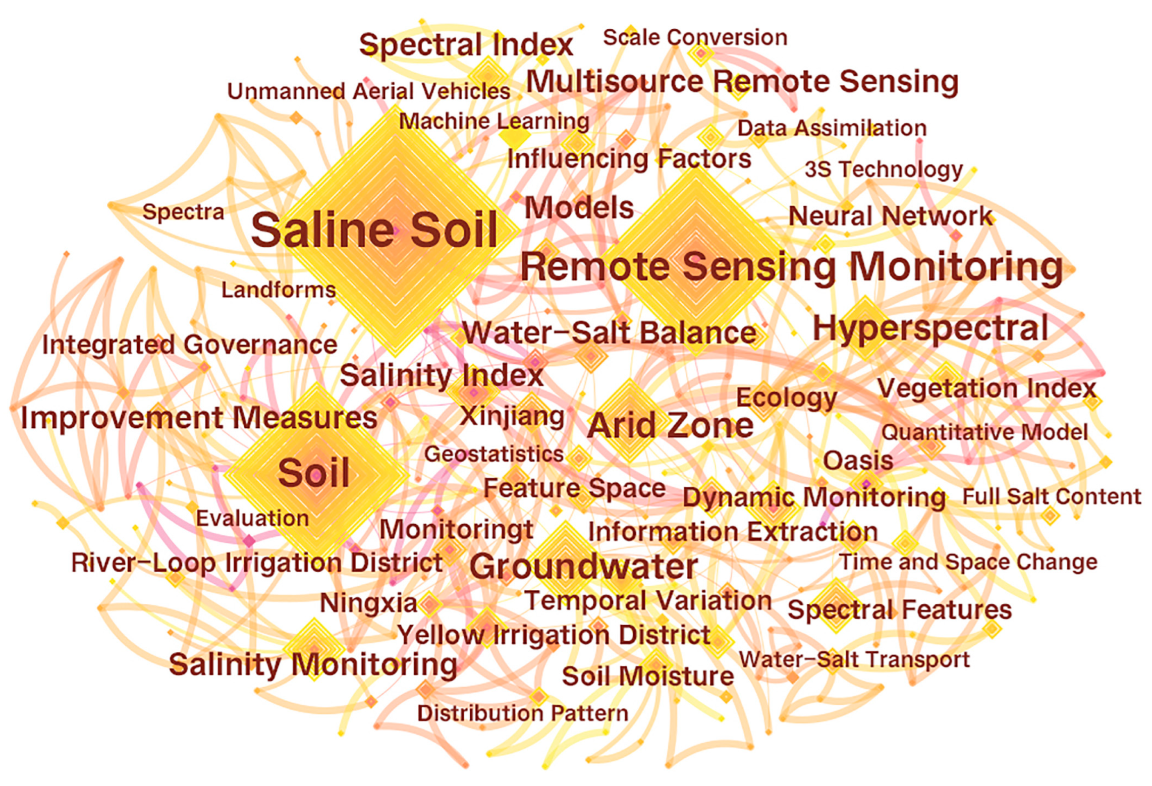
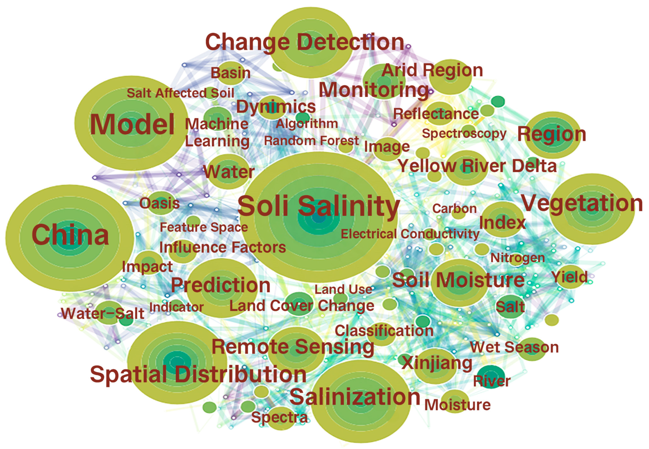
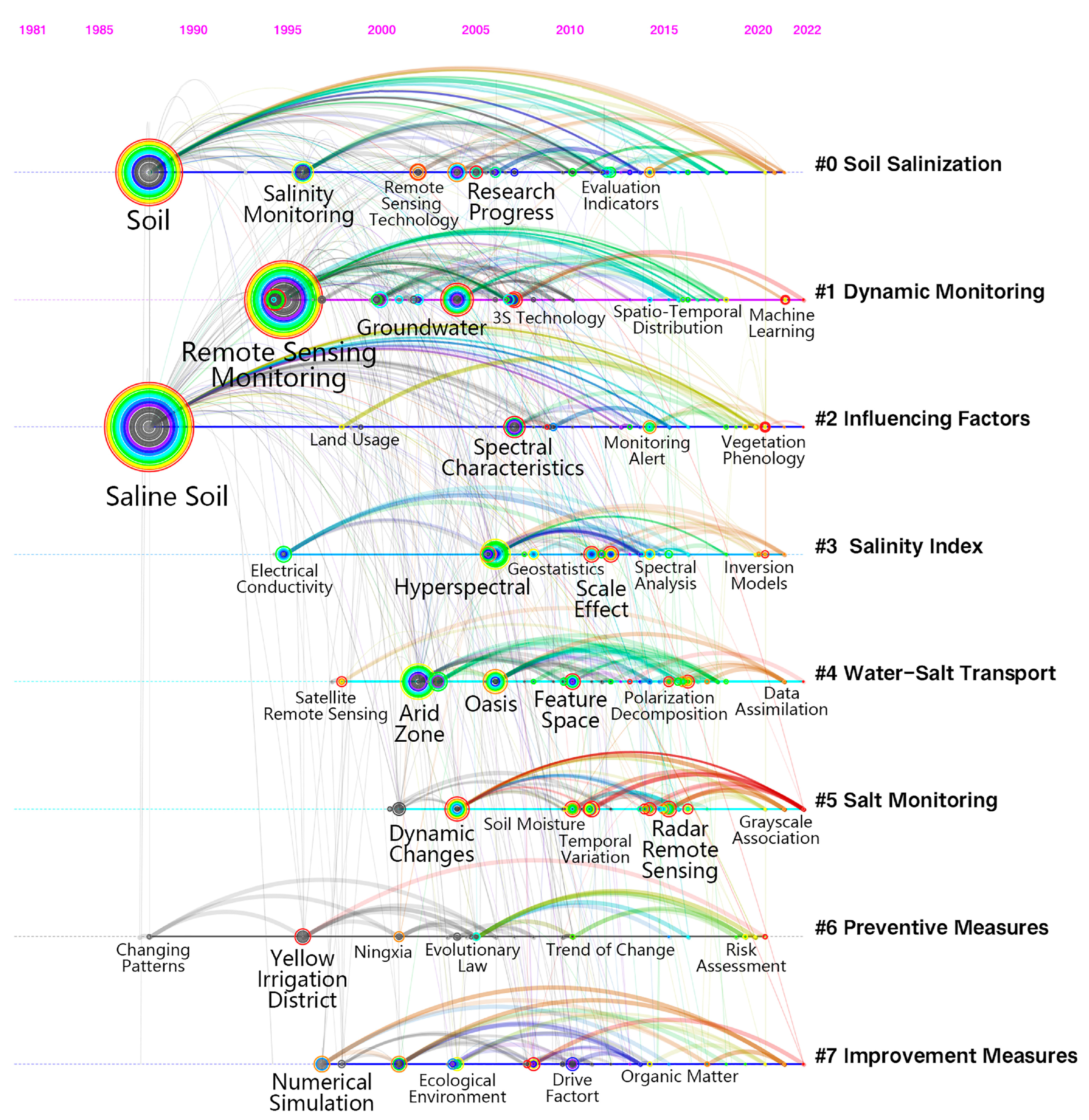
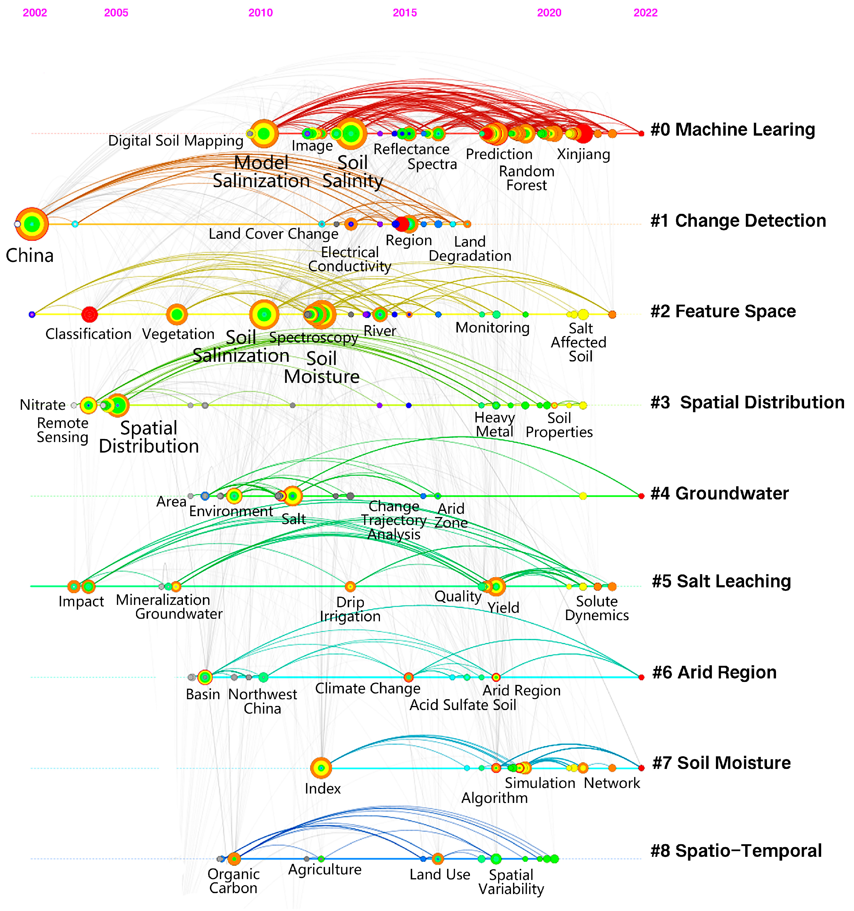
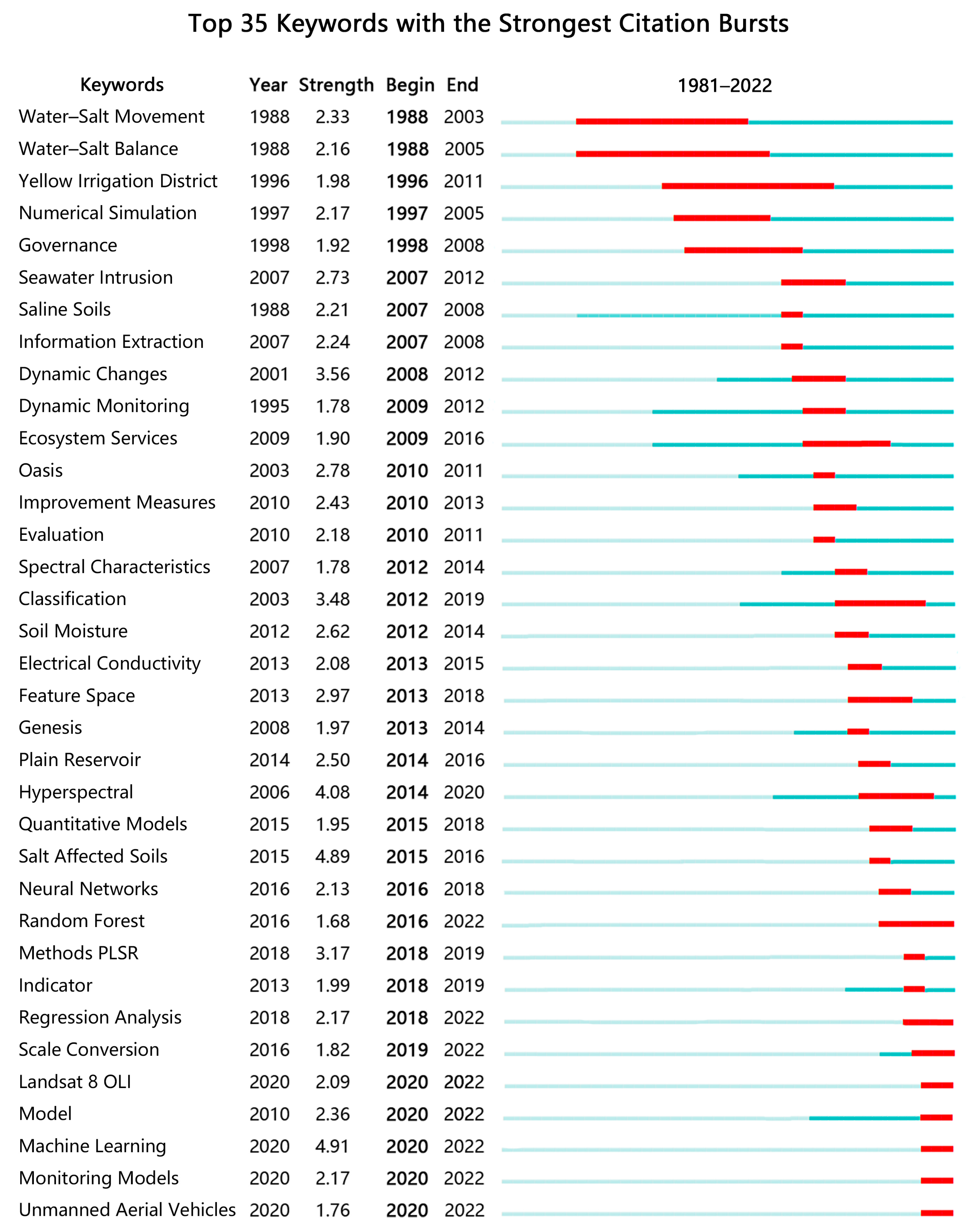
:1. Introduction
2. Research History and Importance of Saline Soil Management in China
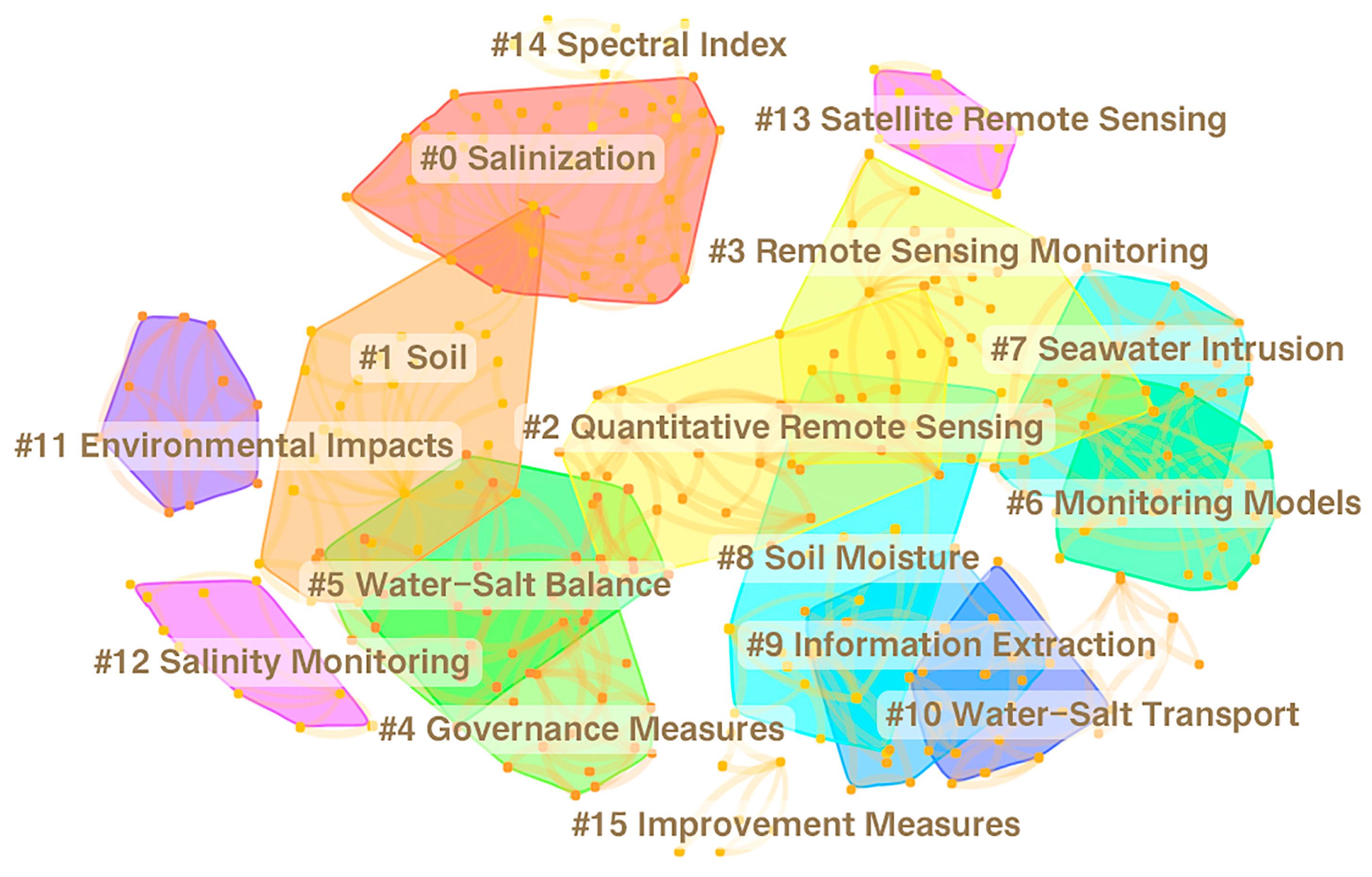
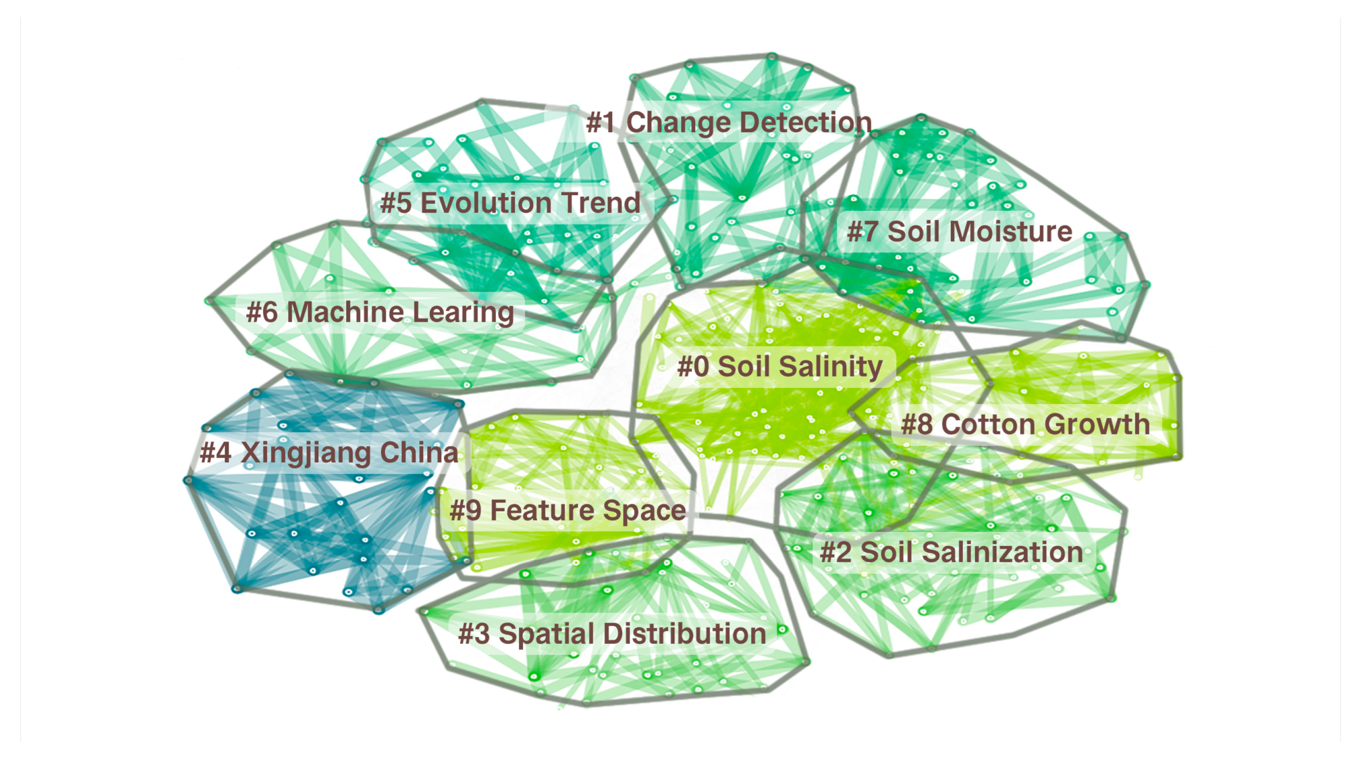
3. Advances in Soil Salinity Monitoring Research
3.1. Field Investigations and Experiments
3.2. Remote Sensing Information Technology Monitoring
4. Main Modeling Approaches for Soil Salinity Remote Sensing Monitoring
4.1. Partial Least Squares Regression
4.2. Support Vector Machines
4.3. BP Neural Network
4.4. Random Forest
4.5. Feature Space
5. Discussion
6. Research Perspectives on Soil Salinity Monitoring in China
7. Conclusions
Author Contributions
Funding
Institutional Review Board Statement
Informed Consent Statement
Data Availability Statement
Acknowledgments
Conflicts of Interest
References
- Guo, S.; Ruan, B.; Chen, H.; Guan, X.; Wang, S.; Xu, N.; Li, Y. Characterizing the spatiotemporal evolution of soil salinization in Hetao Irrigation District (China) using a remote sensing approach. Int. J. Remote Sens. 2018, 39, 6805–6825. [Google Scholar] [CrossRef]
- Ding, J.; Wu, M.; Tiyip, T. Study on soil salinization information in arid region using remote sensing technique. Agric. Sci. China 2011, 10, 404–411. [Google Scholar] [CrossRef]
- Wang, Z.; Zhang, F.; Zhang, X.; Chan, N.W.; Kung, H.-t.; Ariken, M.; Zhou, X.; Wang, Y. Regional suitability prediction of soil salinization based on remote-sensing derivatives and optimal spectral index. Sci. Total Environ. 2021, 775, 145807. [Google Scholar] [CrossRef] [PubMed]
- Wu, Y.; Liu, G.; Su, L.; Yang, J. Accurate evaluation of regional soil salinization using multi-source data. Spectrosc. Spectr. Anal. 2018, 38, 3528–3533. [Google Scholar]
- Li, J.; Pu, L.; Han, M.; Zhu, M.; Zhang, R.; Xiang, Y. Soil salinization research in China: Advances and prospects. J. Geogr. Sci. 2014, 24, 943–960. [Google Scholar] [CrossRef]
- Metternicht, G.I.; Zinck, J.A. Remote sensing of soil salinity: Potentials and constraints. Remote Sens. Environ. 2003, 85, 1–20. [Google Scholar] [CrossRef]
- Yang, J.; Yao, R.; Wang, X.; Xie, W.; Zhang, X.; Zhu, W.; Zhang, L.; Sun, R. Research on salt-affected soils in China: History, status quo and prospect. Acta Pedol. Sin. 2022, 59, 10–27. [Google Scholar] [CrossRef]
- Nawar, S.; Buddenbaum, H.; Hill, J.; Kozak, J. Modeling and mapping of soil salinity with reflectance spectroscopy and Landsat data using two quantitative methods (PLSR and MARS). Remote Sens. 2014, 6, 10813–10834. [Google Scholar] [CrossRef] [Green Version]
- Zhang, Y.; Hu, K.; Li, B.; Zhou, L.; Zhu, J. Spatial distribution pattern of soil salinity and saline soil in yinchuan plain of china. Trans. Chin. Soc. Agric. Eng. 2009, 25, 19–24. [Google Scholar] [CrossRef]
- Wen, W.; Timmermans, J.; Chen, Q.; van Bodegom, P.M. A review of remote sensing challenges for food security with respect to salinity and drought threats. Remote Sens. 2021, 13, 6. [Google Scholar] [CrossRef]
- Zhang, H. Analysis of the distribution and evolution characteristics of saline soils in China. Agric. Technol. 2022, 73, 104–107. [Google Scholar] [CrossRef]
- Zhang, J.L. Understanding of saline soil formation processes. Chin. J. Soil Sci. 1957, 49–51. [Google Scholar] [CrossRef]
- Kan, M.A.W.; Yadav, J.S.P.; Qiao, H.Q. Characteristics of saline land and afforestation problems. For. Sci. Technol. 1962, 22, 2–4. [Google Scholar] [CrossRef]
- Zen, X.X. Overview of soil salinization in Henan Province and experience in its improvement and utilization. Chin. J. Soil Sci. 1961, 1, 28–35. [Google Scholar] [CrossRef]
- Yang, J.S.; Zhu, S.Q. International Symposium on Saline Soil Dynamics held in Nanjing. Soils 1990, 1, 57. [Google Scholar]
- Xu, Y.Z.; Shi, T.K. Study on the saline soil foundation treatments. Ind. Constr. 1991, 3, 7–12+61. [Google Scholar]
- Guo, S.L.; Zhu, X.Y.; Li, F.R. A brief discussion on saline soils and their improvement in the inland saline zone of Hexi. Soil Fertil. Sci. China 1990, 1, 4–7. [Google Scholar]
- Ding, G.W.; Zhao, C.X. The prevention and amelioration of salt-affected land on the loess plateau. J. Arid Land Resour. Environ. 1991, 4, 49–60. [Google Scholar] [CrossRef]
- Zhang, Y.H.; Fen, H.C.; Yi, Z.R.; Li, Y.Y.; Gui, L.G.; Wang, T.N.; Wang, P.; Huang, J.C. Research and demonstration of highly efficient utilization technology model for saline land agriculture in Ningxia Irrigation Area. Inst. Agric. Resour. Environ. Ningxia Acad. Agric. For. Sci. 2013, 11, 28. [Google Scholar]
- Liang, X.; Gy, A.; Lf, B.; Db, B.; Jing, W. Soil properties and the growth of wheat (Triticum aestivum L.) and maize (Zea mays L.) in response to reed (phragmites communis) biochar use in a salt-affected soil in the Yellow River Delta. Agric. Ecosyst. Environ. 2020, 303, 107124. [Google Scholar] [CrossRef]
- National Development and Reform Commission. Development and reform of agricultural economics. No. [2014]594. Guidance on strengthening saline land management. Xinjiang Water Resour. 2014, 3, 28–29. [Google Scholar]
- Xiao, K.B. Experimental Study on Mechanism of Halophyteremediation in Alkali-Saline Soil in the North Region of Yin Chuan City Ningxia Province. Ph.D. Thesis, Northwest Agriculture and Forestry University, Xianyang, China, 2013. [Google Scholar]
- Li, H.Y. Study on the Effect of Biological Measures on the Improvement of Saline Degraded Grassland in Songnen Plain. Ph.D. thesis, Northeast Agricultural University, Harbin, China, 2014. [Google Scholar]
- Yang, J.S.; Yao, R.J. Management and efficient agricultural utilization of salt-affected soil in China. Bull. Chin. Sci. 2015, 30, 162–170. [Google Scholar]
- Wen, K.J.; Liu, J.; Wu, L.P. Evaluation of sustainability for ecological restoration of saline soil using planting hole control body. Environ. Sci. Technol. 2013, 36, 200–205. [Google Scholar]
- Ma, X.L.; Meng, J.S.; Fu, D.P. Study on environmental geological problems and prevention countermeasures of typical ecologically vulnerable areas, Take the Bashang area in Hebei as an example. Ground Water 2020, 42, 122–126. [Google Scholar] [CrossRef]
- Du, X.J.; Hu, S.W. Research progress of saline-alkali land at home and abroad over the past 30 years based on biliometric analysis. J. Anhui Agric. Sci. 2021, 49, 236–239. [Google Scholar]
- Yang, G.S.; Wang, X.P.; Yao, R.J. Halt soil salinization, Boost soil productivity. Science 2021, 73, 30–34+2+4. [Google Scholar]
- Zhang, Y.; Xiao, H.; Nie, X.; Zhongwu, L.I.; Deng, C.; Zhou, M. Evolution of research on soil erosion at home and abroad in the past 30 years-based on bibliometric analysis. Acta Pedol. Sin. 2020, 57, 797–810. [Google Scholar] [CrossRef]
- Park, S.; Lee, B.; Lee, J.; Kim, T. S nutrition alleviates salt stress by maintaining the assemblage of photosynthetic organelles in Kentucky bluegrass (Poa pratensis L.). Plant Growth Regul. 2016, 79, 367–375. [Google Scholar] [CrossRef]
- Corwin, D.L.; Lesch, S.M. Apparent soil electrical conductivity measurements in agriculture. Comput. Electron. Agric. 2005, 46, 11–43. [Google Scholar] [CrossRef]
- Gong, L.; Han, L.; Ren, M.; Gui, D. Spatial variability of soil water-salt in a typical oasis on the upper reaches of the Tarim River. J. Soil Water Conserv. 2012, 26, 251–255. [Google Scholar] [CrossRef]
- Wang, D.L.; Shu, Y.G.; University, G.J. Research progress in determination methods for soil water content. J. Mt. Agric. Biol. 2017, 36, 061–065. [Google Scholar] [CrossRef]
- Al-Ali, Z.M.; Bannari, A.; Rhinane, H.; El-Battay, A.; Shahid, S.A.; Hameid, N. Validation and comparison of physical models for soil salinity mapping over an arid landscape using spectral reflectance measurements and Landsat-OLI data. Remote Sens. 2021, 13, 494. [Google Scholar] [CrossRef]
- Liu, H.; Chu, G.; Zhao, F.; Huang, Q.; Wang, F. Study on the variation and trend analysis of soil secondary salinization of cotton field under long-term drip irrigation condition in northern Xinjiang. Soil Fertil. Sci. China 2010, 4, 12–17. [Google Scholar] [CrossRef]
- Deng, K.; Ding, J.; Yang, A.; Wang, S. Modeling of the spatial distribution of soil profile salinity based on the electromagnetic induction technique. Acta Ecol. Sin. 2016, 36, 6387–6396. [Google Scholar] [CrossRef]
- Xie, W.; Yang, J.; Yao, R.; Wang, X. Spatial and temporal variability of soil salinity in the Yangtze River estuary using electromagnetic induction. Remote Sens. 2021, 13, 1875. [Google Scholar] [CrossRef]
- Yasenjiang, K.; Yang, S.; Nigara, T.; Zhang, F. Hyperspectral estimation of soil electrical conductivity based on fractional order differentially optimised spectral indices. Acta Ecol. Sin. 2019, 39, 7237–7248. [Google Scholar] [CrossRef]
- Li, Y.; Zhao, G.; Chang, C.; Wang, Z.; Wang, L.; Zheng, J. Soil salinity retrieval model based on OLI and HSI image fusion. Trans. Chin. Soc. Agric. Eng. 2017, 33, 173–180. [Google Scholar] [CrossRef]
- Ivushkin, K.; Bartholomeus, H.; Bregt, A.K.; Pulatov, A. Satellite thermography for soil salinity assessment of cropped areas in Uzbekistan. Land Degrad. Dev. 2017, 28, 870–877. [Google Scholar] [CrossRef] [Green Version]
- Alqasemi, A.S.; Ibrahim, M.; Al-Quraishi, A.M.F.; Saibi, H.; Al-Fugara, A.k.; Kaplan, G. Detection and modeling of soil salinity variations in arid lands using remote sensing data. Open Geosci. 2021, 13, 443–453. [Google Scholar] [CrossRef]
- Perri, S.; Suweis, S.; Holmes, A.; Marpu, P.R.; Entekhabi, D.; Molini, A. River basin salinization as a form of aridity. Proc. Natl. Acad. Sci. USA 2020, 117, 17635–17642. [Google Scholar] [CrossRef]
- Aldabaa, A.A.A.; Weindorf, D.C.; Chakraborty, S.; Sharma, A.; Li, B. Combination of proximal and remote sensing methods for rapid soil salinity quantification. Geoderma 2015, 239, 34–46. [Google Scholar] [CrossRef] [Green Version]
- Zhang, F. The Study on the Saline Soil Spectrum, Spatial Characteristic and Composition in the Arid Regions: A Case Study in the Delta Oasis of Weigan and Kuqa Rivers. Master’s Thesis, Xinjiang University, Ürümqi, China, 2007. [Google Scholar]
- Zhang, S. Application and Improvement of electrical conductivity measurements in soil salinity. Chin. J. Soil Sci. 2014, 45, 754–759. [Google Scholar] [CrossRef]
- Zarai, B.; Walter, C.; Michot, D.; Pmontoroi, J.; Hachicha, M. Integrating multiple electromagnetic data to map spatiotemporal variability of soil salinity in Kairouan region, Central Tunisia. J. Arid Land 2022, 14, 186–202. [Google Scholar] [CrossRef]
- Sun, G.; Zhu, Y.; Gao, Z. Spatiotemporal Patterns and key driving factors of soil salinity in dry and wet years in an arid agricultural area with shallow groundwater table. Agriculture 2022, 12, 1243. [Google Scholar] [CrossRef]
- Du, X.J.; Yan, B.W.; Xu, K.; Wang, S.Y. Research progress on water-salt transport theories and models in saline-alkali soil. Chin. J. Soil Sci. 2021, 52, 713–721. [Google Scholar] [CrossRef]
- Xiu, X.F.; Pu, L.J. Evolution and prospects in modeling of water and salt transport in soils. Sci. Geogr. Sin. 2016, 36, 1565–1572. [Google Scholar] [CrossRef]
- Guo, J.Y. Pollution assessment and hyperspectral monitoring of heavy metal farmland soils in Ebinur Lake Basin. Xinjiang Univ. 2022, 3, 1–84. [Google Scholar] [CrossRef]
- Tang, R.; Zhang, X.H.; Wang, W.Y.; Shi, X.Y.; Li, P. Determination and analysis of heavy metals Cd-Zn-Cu in salinized soils of Heilonggang watershed. J. Xingtai Univ. 2020, 35, 182–185. [Google Scholar]
- Zhang, X.; Huang, B.; Liu, F. Information extraction and dynamic evaluation of soil salinization with a remote sensing method in a typical county on the Huang-Huai-Hai Plain of China. Pedosphere 2020, 30, 496–507. [Google Scholar] [CrossRef]
- Qi, G.; Chang, C.; Yang, W.; Gao, P.; Zhao, G. Soil salinity inversion in coastal corn planting areas by the satellite-UAV-ground integration approach. Remote Sens. 2021, 13, 3100. [Google Scholar] [CrossRef]
- Zhou, X.; Zhang, F.; Liu, C.; Kung, H.-t.; Johnson, V.C. Soil salinity inversion based on novel spectral index. Environ. Earth Sci. 2021, 80, 501. [Google Scholar] [CrossRef]
- Li, Y.; Ding, J.; Sun, Y.; Wang, G.; Wang, L. Remote sensing monitoring models of soil salinization based on the three dimensional feature space of MSAVI-WI-SI. Res. Soil Water Conserv. 2015, 22, 113–117+121. [Google Scholar] [CrossRef]
- Wang, M.; Mo, H.; Chen, H. Study on model method of inversion of soil salt based on multispectral image. Chin. J. Soil Sci. 2016, 47, 1036–1041. [Google Scholar] [CrossRef]
- Umut, H.; Mamat, S.; Yiliyas, N.; Wang, J. Soil salinity inversion model based on WorldView-2 images. Trans. Chin. Soc. Agric. Eng. 2017, 33, 200–206. [Google Scholar] [CrossRef]
- Samiee, M.; Ghazavi, R.; Pakparvar, M.; Vali, A.A. Mapping spatial variability of soil salinity in a coastal area located in an arid environment using geostatistical and correlation methods based on the satellite data. Desert 2018, 23, 233–242. [Google Scholar] [CrossRef]
- Chen, J.; Wang, X.; Zhang, Z.; Han, J.; Yao, Z.; Wei, G.J. Soil salinization monitoring method based on UAV-satellite remote sensing scale-up. Trans. Chin. Soc. Agric. 2019, 53, 226–238. [Google Scholar] [CrossRef]
- Zaytungul, Y.; Mamat, S.; Abdusalam, A.; Zhang, D. Soil salinity inversion in Yutian Oasis based on PALSAR radar data. Resour. Sci. 2018, 40, 2110–2117. [Google Scholar] [CrossRef]
- Li, Y.; Guo, Q.; Wan, B.; Qing, H.; Wang, D.; Xu, K.; Song, S.; Sun, Q.; Zhao, X.; Yang, M.; et al. Current status and prospect of three-dimensional dynamic monitoring of natural resources based on LiDAR. Natl. Remote Sens. Bull. 2021, 25, 381–402. [Google Scholar] [CrossRef]
- An, D.; Xing, Q.; Zhao, G. Hyperspectral remote sensing of soil salinity for coastal saline soil in the Yellow River Delta based on HICO bands. Acta Oceanol. Sin. 2018, 40, 51–59. [Google Scholar] [CrossRef]
- Bian, J.; Zhang, Z.; Chen, J.; Chen, H.; Cui, C.; Li, X.; Chen, S.; Fu, Q. Simplified evaluation of cotton water stress using high resolution unmanned aerial vehicle thermal imagery. Remote Sens. 2019, 11, 267. [Google Scholar] [CrossRef] [Green Version]
- Zhang, Z.; Tan, C.; Xu, C.; Chen, S.; Han, W.; Li, Y. Retrieving soil moisture content in field maize root zone based on UAV multispectral remote sensing. Trans. Chin. Soc. Agric. Mach. 2019, 50, 246–257. [Google Scholar] [CrossRef]
- Chen, S.; Chen, Y.; Chen, J.; Zhang, Z.; Fu, Q.; Bian, J.; Cui, T.; Ma, Y. Retrieval of cotton plant water content by UAV-based vegetation supply water index (VSWI). Int. J. Remote Sens. 2020, 41, 4389–4407. [Google Scholar] [CrossRef]
- Zhang, Z.; Wei, G.; Yao, Z.; Tan, C.; Wang, X.; Han, J. Soil salt inversion model based on UAV multispectral remote sensing. Trans. Chin. Soc. Agric. Mach. 2019, 50, 151–160. [Google Scholar] [CrossRef]
- Ding, J.; Wang, F. Environmental modeling of large-scale soil salinity information in an arid region: A case study of the low and middle altitude alluvial plain north and south of the Tianshan Mountains, Xinjiang. Acta Geogr. Sin. 2017, 72, 64–78. [Google Scholar] [CrossRef]
- Li, X.; Zhang, F.; Wang, Z. Present situation and development trend of remote sensing monitoring model for soil salinization. Remote Sens. Nat. Resour. 2022, 34, 11–21. [Google Scholar] [CrossRef]
- Khan, N.M.; Rastoskuev, V.V.; Sato, Y.; Shiozawa, S. Assessment of hydrosaline land degradation by using a simple approach of remote sensing indicators. Agric. Water Manag. 2005, 77, 96–109. [Google Scholar] [CrossRef]
- Allbed, A.; Kumar, L.; Aldakheel, Y.Y. Assessing soil salinity using soil salinity and vegetation indices derived from IKONOS high-spatial resolution imageries: Applications in a date palm dominated region. Geoderma 2014, 230, 1–8. [Google Scholar] [CrossRef]
- Douaoui, A.E.K.; Nicolas, H.; Walter, C. Detecting salinity hazards within a semiarid context by means of combining soil and remote-sensing data. Geoderma 2006, 134, 217–230. [Google Scholar] [CrossRef]
- Wang, F.; Ding, J.; Wei, Y.; Zhou, Q.; Yang, X.; Wang, Q. Sensitivity analysis of soil salinity and vegetation indices to detect soil salinity variation by using Landsat series images: Applications in different oases in Xinjiang, China. Acta Ecol. Sin. 2017, 37, 5007–5022. [Google Scholar]
- Ar, H.; Batchily, K.; Vanleeuwen, W.; Liu, H.J. A comparison of vegetation indices global set of TM images for Eos-MODIS. Remote Sens. Environ. Interdiscip. J. 1997, 59, 440–451. [Google Scholar] [CrossRef]
- Abbas, A.; Khan, S.; Hussain, N.; Hanjra, M.A.; Akbar, S. Characterizing soil salinity in irrigated agriculture using a remote sensing approach. Phys. Chem. Earth 2013, 55–57, 43–52. [Google Scholar] [CrossRef]
- Taylor, G.R.; Mah, A.H.; Kruse, F.A.; Kierein-Young, K.S.; Hewson, R.D.; Bennett, B.A. Characterization of saline soils using airborne radar imagery. Remote Sens. Environ. 1996, 57, 127–142. [Google Scholar] [CrossRef]
- Khan, N.M.; Rastoskuev, V.V.; Shalina, E.V.; Sato, Y. Mapping salt-affected soils using remote sensing indicators—A simple approach with the use of GIS IDRISI. In Proceedings of the 22nd Asian Conference on Remote Sensing, Ulaanbaatar, Mongolia, 3–5 October 2022. [Google Scholar]
- Fourati, H.T.; Bouaziz, M.; Benzina, M.; Bouaziz, S.J. Modeling of soil salinity within a semi-arid region using spectral analysis. Arab. J. Geosci. 2015, 8, 11175–11182. [Google Scholar] [CrossRef]
- Birth, G.S.; Mcvey, G.R.J. Measuring the color of growing turf with a reflectance spectrophotometer. Agron. J. 1968, 60, 640–643. [Google Scholar] [CrossRef]
- Mcfeeters, S.K. The use of the Normalized Difference Water Index (NDWI) in the delineation of open water features. Int. J. Remote Sens. 2007, 17, 1425–1432. [Google Scholar] [CrossRef]
- Scudiero, E.; Skaggs, T.H.; Corwin, D.L. Regional scale soil salinity evaluation using Landsat 7, western San Joaquin Valley, California, USA. Geoderma Reg. 2014, 2–3, 82–90. [Google Scholar] [CrossRef]
- Taghizadeh-Mehrjardi, R.; Minasny, B.; Sarmadian, F.; Malone, B.P. Digital mapping of soil salinity in Ardakan region, central Iran. Geoderma 2014, 213, 15–28. [Google Scholar] [CrossRef]
- Alhammadi, M.S.; Glenn, E.P. Detecting date palm trees health and vegetation greenness change on the eastern coast of the United Arab Emirates using SAVI. Int. J. Remote Sens. 2008, 29, 1745–1765. [Google Scholar] [CrossRef]
- Fang, X.; Gao, J.; Xie, C.; Zhu, F.; Huang, L.; He, Y. Review of crop canopy spectral information detection technology and methods. Spectrosc. Spectr. Anal. 2015, 35, 1949–1955. [Google Scholar] [CrossRef]
- Huete, A.; Didan, K.; Miura, T.; Rodriguez, E.P.; Gao, X.; Ferreira, L.G. Overview of the radiometric and biophysical performance of the MODIS vegetation indices. Remote Sens. Environ. 2002, 83, 195–213. [Google Scholar] [CrossRef]
- Jordan, C.F. Derivation of leaf area index from light quality of the forest floor. Ecology 1969, 50, 663–666. [Google Scholar] [CrossRef]
- Tucker, C.J. Red and photographic infrared linear combinations for monitoring vegetation. Remote Sens. Environ. 1979, 8, 127–150. [Google Scholar] [CrossRef] [Green Version]
- Roujean, J.L.; Breon, F.M. Estimating PAR absorbed by vegetation from bidirectional reflectance measurements. Remote Sens. Environ. 1995, 51, 375–384. [Google Scholar] [CrossRef]
- Wu, W.; Ahmad, S.M.; Boubaker, D.; Eddy, D.P. Mapping soil salinity changes using remote sensing in Central Iraq. Geoderma Reg. 2014, 2–3, 21–31. [Google Scholar] [CrossRef]
- Bunkei, M.; Wei, Y.; Chen, J.; Yuyichi, O.; Qiu, G. Sensitivity of the enhanced vegetation index (evi) and normalized difference vegetation index (ndvi) to topographic effects: A case study in high-density cypress forest. Sensors 2007, 11, 2636. [Google Scholar] [CrossRef] [Green Version]
- Gitelson, A.A.; Kaufman, Y.J.; Merzlyak, M.N. Use of a green channel in remote sensing of global vegetation from EOS-MODIS. Remote Sens. Environ. 1996, 58, 289–298. [Google Scholar] [CrossRef]
- Gitelson, A.A.; Merzlyak, M.N. Remote sensing of chlorophyll concentration in higher plant leaves. Adv. Space Res. 1998, 22, 689–692. [Google Scholar] [CrossRef]
- Liu, H.Q.; Huete, A. A feedback based modification of the NDVI to minimize canopy background and atmospheric noise. IEEE Trans. Geosci. Remote Sens. 1995, 33, 457–465. [Google Scholar] [CrossRef]
- Jiang, Z.; Huete, A.R.; Didan, K.; Miura, T. Development of a two-band enhanced vegetation index without a blue band. Remote Sens. Environ. 2008, 112, 3833–3845. [Google Scholar] [CrossRef]
- Sishodia, R.P.; Ray, R.L.; Singh, S.K. Applications of remote sensing in precision agriculture: A review. Remote Sens. 2020, 12, 3136. [Google Scholar] [CrossRef]
- Brunner, P.; Li, H.T.; Kinzelbach, W.; Li, W.P. Generating soil electrical conductivity maps at regional level by integrating measurements on the ground and remote sensing data. Int. J. Remote Sens. 2007, 28, 3341–3361. [Google Scholar] [CrossRef]
- Peng, G.; Pu, R.; Biging, G.S.; Larrieu, M.R. Estimation of forest leaf area index using vegetation indices derived from Hyperion hyperspectral data. IEEE Trans. Geosci. Remote Sens. 2003, 41, 1355–1362. [Google Scholar] [CrossRef] [Green Version]
- Sims, D.A.; Gamon, J.A. Relationships between leaf pigment content and spectral reflectance across a wide range of species, leaf structures and developmental stages. Remote Sens. Environ. 2002, 81, 337–354. [Google Scholar] [CrossRef]
- Haboudane, D.; Miller, J.R.; Pattey, E.; Zarco-Tejada, P.J.; Strachan, I.B. Hyperspectral vegetation indices and novel algorithms for predicting green LAI of crop canopies: Modeling and validation in the context of precision agriculture. Remote Sens. Environ. 2004, 90, 337–352. [Google Scholar] [CrossRef]
- Gitelson, A.A.; Gritz, Y.; Merzlyak, M.N. Relationships between leaf chlorophyll content and spectral reflectance and algorithms for non-destructive chlorophyll assessment in higher plant leaves. J. Plant Physiol. 2003, 160, 271–282. [Google Scholar] [CrossRef]
- Huete, A.R. A soil-adjusted vegetation index (SAVI). Remote Sens. Environ. 1988, 25, 295–309. [Google Scholar] [CrossRef]
- Sripada, R.P.; Heiniger, R.W.; White, J.G.; Meijer, A.D. Aerial color infrared photography for determining early in-season nitrogen requirements in corn. Agron. J. 2006, 98, 968–977. [Google Scholar] [CrossRef]
- Baret, S.F. Optimization of soil-adjusted vegetation indices. Remote Sens. Environ. 1996, 55, 95–107. [Google Scholar] [CrossRef]
- Okin, G.S.; Clarke, K.D.; Lewis, M.M. Comparison of methods for estimation of absolute vegetation and soil fractional cover using MODIS normalized BRDF-adjusted reflectance data. Remote Sens. Environ. 2013, 130, 266–279. [Google Scholar] [CrossRef] [Green Version]
- Fernandez, B.N.; Siebe, C.; Cram, S.; Palacio, J.L. Mapping soil salinity using a combined spectral response index for bare soil and vegetation: A case study in the former lake Texcoco, Mexico. J. Arid Environ. 2006, 65, 644–667. [Google Scholar] [CrossRef]
- Gitelson, A.A.; Stark, R.; Grits, U.; Rundquist, D.; Kaufman, Y.; Derry, D. Vegetation and soil lines in visible spectral space: A concept and technique for remote estimation of vegetation fraction. Int. J. Remote Sens. 2002, 23, 2537–2562. [Google Scholar] [CrossRef]
- Wang, J.; Peng, J.; Li, H.; Yin, C.; Liu, W.; Wang, T.; Zhang, H. Soil salinity mapping using machine learning algorithms with the Sentinel-2 MSI in arid areas, China. Remote Sens. 2021, 13, 305. [Google Scholar] [CrossRef]
- Song, C.; Ren, H.; Huang, C.; Botany, I.O.; Sciences, C. Estimating soil salinity in the yellow river delta, eastern chin—An integrated approach using spectral and terrain indices with the generalized additive model. Pedosphere 2016, 26, 626–635. [Google Scholar] [CrossRef]
- Chen, H.; Xu, X.; Zou, C. Study of a gis-supported remote sensing method and a model for monitoring soil moisture at depth. In Ecosystems’ Dynamics, Agricultural Remote Sensing and Modeling, and Site-Specific Agriculture; SPIE: Bellingham, WA, USA, 2003; Volume 5153, pp. 147–152. [Google Scholar] [CrossRef]
- Jiang, H.; Shu, H. Optical remote-sensing data based research on detecting soil salinity at different depth in an arid-area oasis, Xinjiang, China. Earth Sci. Inform. 2019, 12, 43–56. [Google Scholar] [CrossRef]
- Ma, G.; Ding, J.; Han, L.; Zhang, Z. Digital mapping of soil salinization in arid area wetland based on variable optimized selection and machine learning. Trans. Chin. Soc. Agric. Eng. 2020, 36, 124–131. [Google Scholar] [CrossRef]
- Jiang, Y.; Wang, R.; Li, Y.; Li, C.; Peng, Q.; Wu, X. Hyper-spectral retrieval of soil nutrient content of various land-cover types in Ebinur Lake Basin. Chin. J. Eco-Agric. 2016, 24, 1555–1564. [Google Scholar] [CrossRef]
- Rossel, R.A.V.; Behrens, T. Using data mining to model and interpret soil diffuse reflectance spectra. Geoderma 2010, 158, 46–54. [Google Scholar] [CrossRef]
- Cui, S.; Zhou, K.; Ding, R. Extraction of plant abnormal information in mining area based on hyperspectral. Spectrosc. Spectr. Anal. 2019, 39, 241–249. [Google Scholar]
- Yumiti, M.; Wang, X. Hyperspectral estimation of soil organic matter content based on continuous wavelet transformation. Spectrosc. Spectr. Anal. 2022, 42, 1278–1284. [Google Scholar] [CrossRef]
- Guan, X.; Wang, S.; Gao, Z.; Lv, Y. Dynamic prediction of soil salinization in an irrigation district based on the support vector machine. Math. Comput. Model. 2013, 58, 719–724. [Google Scholar] [CrossRef]
- Tan, K.; Ye, Y.Y.; Du, P.; Zhang, Q. Estimation of heavy metal concentrations in reclaimed mining soils using reflectance spectroscopy. Spectrosc. Spectr. Anal. 2014, 34, 3317–3322. [Google Scholar] [CrossRef]
- Tan, K.J. Hyperspectral remote sensing image classification based on support vector machine. J. Infrared Millim. Waves 2008, 27, 123–128. [Google Scholar] [CrossRef]
- Fei, Z.; Tashpolat, T.; Jianli, D.; Yuan, T.; Ilyas, N.; Xueping, H.A. Extracting of soil salinization by SVM and accuracy evaluation based on texture characteristic. Arid Land Geogr. 2009, 32, 57–66. [Google Scholar] [CrossRef]
- Yiliyas, J. Remote Sensing Monitoring of Soil Salinization based on Fusion and Classification of Radar and TM Image. Ph.D. Thesis, Xinjiang University, Ürümqi, China, 2008. [Google Scholar]
- Wang, X.; Li, Y.H.; Wang, R.Y.; Shi, R.F.; Xu, S.T. Remote sensing inversion of surface soil organic matter at jointing stage of winter wheat based on unmanned aerial vehicle multispectral. Chin. J. Appl. Ecol. 2020, 31, 2399–2406. [Google Scholar] [CrossRef]
- Chen, S.; Gao, C.; Xu, B.; Jin, Y.; Li, J.; Ma, H.; Zhao, F.; Guo, J.; Yang, X. Quantitative inversion of soil salinity and analysis of its spatial pattern in agricultural area in Shihezi of Xinjiang. Geogr. Res. 2014, 33, 2135–2144. [Google Scholar]
- Feng, W.; Wang, X.; Han, J. Research on soil salinization monitoring based on scale conversion of satellite and UAV remote sensing data. J. Shandong Univ. Sci. Technol. (Nat. Sci.) 2020, 11, 87–93. [Google Scholar]
- Feng, X.; Liu, Q. Regional soil salinity monitoring based on multi-source collaborative remote sensing data. Trans. Chin. Soc. Agric. Mach. 2018, 49, 127–133. [Google Scholar] [CrossRef]
- Wang, F.; Yang, S.; Ding, J.; Wei, Y.; Ge, X.; Liang, J. Environmental sensitive variable optimization and machine learning algorithm using in soil salt prediction at oasis. Trans. Chin. Soc. Agric. Eng. 2018, 34, 102–110. [Google Scholar] [CrossRef]
- Mutanga, O.; Adam, E.; Cho, M.A. High density biomass estimation for wetland vegetation using WorldView-2 imagery and random forest regression algorithm. Int. J. Appl. Earth Obs. Geoinf. 2012, 18, 399–406. [Google Scholar] [CrossRef]
- Kennedy, W.; Dieu, T.; Bui, Y. A comparative assessment of support vector regression, artificial neural networks, and random forests for predicting and mapping soil organic carbon stocks across an Afromontane landscape. Ecol. Indic. 2015, 52, 394–403. [Google Scholar] [CrossRef]
- Hu, J. Estimation of Soil Salinity in Arid Area based on Multi-Source Remote Sensing. Ph.D. Thesis, Zhejiang University, Hangzhou, China, 2019. [Google Scholar]
- Meng, L.; Ding, J.; Wang, J.; Ge, X. Spatial distribution of soil salinity in Ugan-Kuqa River delta oasis based on environmental variables. Trans. Chin. Soc. Agric. Eng. 2020, 36, 175–181. [Google Scholar] [CrossRef]
- Ding, J.; Yao, Y.; Wang, F. Quantitative remote sensing of soil salinization in arid regions based on three dimensional spectrum eigen spaces. Acta Pedol. Sin. 2013, 50, 853–861. [Google Scholar] [CrossRef]
- Guo, B.; Yang, F.; Han, B.; Fan, Y.; Chen, S.; Yang, W.; Jiang, L. A model for the rapid monitoring of soil salinization in the Yellow River Delta using Landsat 8 OLI imagery based on VI-SI feature space. Remote Sens. Lett. 2019, 10, 796–805. [Google Scholar] [CrossRef]
- Ding, J.; Qu, J.; Sun, Y.; Zhang, Y. The retrieval model of soil salinization information in arid region based on MSAVI-WI feature space:A case study of the delta oasis in Weigan-Kuqa watershed. Geogr. Res. 2013, 32, 223–232. [Google Scholar]
- Wang, F.; Ding, J.; Wu, M. Remote sensing monitoring models of soil salinization based on NDVI-SI feature space. Trans. Chin. Soc. Agric. Eng. 2010, 26, 168–173. [Google Scholar] [CrossRef]
- Bian, L.; Wang, J.; Guo, B.; Cheng, K.; Wei, H. Remote sensing extraction of soil salinity in Yellow River Delta Kenli County based on Feature Space. Remote Sens. Technol. Appl. 2020, 35, 211–218. [Google Scholar]
- Feng, J.; Ding, J.L.; Wei, W.Y. A Study of Soil Salinization in Weigan and Kuqa Rivers Oasis Based on Albedo-MSAVI Feature Space. China Rural Water Hydropower 2018, 2, 147–152. [Google Scholar]
- Ha, X.; Ding, J.; Tashpolat, T.; Luo, J.; Zhang, F. SI-Albedo space-based extraction of salinization information in arid area. Acta Pedol. Sin. 2009, 46, 381–390. [Google Scholar] [CrossRef]
- Bi, D.; He, Q.; Li, J.L.; Lu, Z.; Zhou, C.; Meng, L.; Jiang, H. Study on a dust pollution process in Taklamakan Desert based on vertical observation by UAV. Acta Sci. Circumstantiae 2022, 42, 298–310. [Google Scholar]
- Shiga, Y.; Greene, R.; Scott, K.M. Recognising terrestrially-derived salt (NaCl) in SE australian dust. Aeolian Res. 2011, 2, 215–220. [Google Scholar] [CrossRef]
- Olaya-Abril, A.; Parras-Alcántara, L.; Lozano-García, B.; Obregón-Romero, R. Soil organic carbon distribution in Mediterranean areas under a climate change scenario via multiple linear regression analysis. Sci. Total Environ. 2017, 592, 134–143. [Google Scholar] [CrossRef] [PubMed]
- Wang, J.; Zhenhai, L.I.; Zhu, H.; Xingang, X.U.; Gan, P.; Wang, H.; Yang, G.J. Estimation of salt content in saline alkali soil based on field-derived spectra of salinized soils. J. Shandong Univ. Sci. 2017, 36, 17–24. [Google Scholar] [CrossRef]
- Kahaer, Y.; Tashpolat, N.; Shi, Q.; Liu, S. Possibility of Zhuhai-1 hyperspectral imagery for monitoring salinized soil moisture content using fractional order differentially optimized spectral indices. Water 2020, 12, 3360. [Google Scholar] [CrossRef]
- Wang, H.F.; Zhang, Z.T.; Qiu-Ping, F.U.; Chen, S.B.; Bian, J.; Cui, T. Inversion of soil moisture content based on multispectral remote sensing data of low altitude UAV. Water Sav. Irrig. 2018, 1, 90–94. [Google Scholar]
- Scudiero, E.; Skaggs, T.H.; Corwin, D.L. Comparative regional-scale soil salinity assessment with near-ground apparent electrical conductivity and remote sensing canopy reflectance. Ecol. Indic. 2016, 70, 276–284. [Google Scholar] [CrossRef] [Green Version]
- Peng, S.; Li, C.; Huang, J.; Wang, F.J. The prediction of soil moisture model based on partial least-squares regression. J. Agric. Mech. 2010, 32, 45–49. [Google Scholar] [CrossRef]
- Lombardo, L.; Saia, S.; Schillaci, C.; Mai, P.M.; Huser, R. Modeling soil organic carbon with quantile regression: Dissecting predictors’ effects on carbon stocks. Geoderma Int. J. Soil Sci. 2018, 318, 148–159. [Google Scholar] [CrossRef] [Green Version]
- Jia, P.; Shang, T.; Zhang, J.; Yuan, S. Inversion of soil pH during the dry and wet seasons in the Yinbei region of Ningxia, China, based on multi-source remote sensing data. Geoderma Reg. 2021, 25, e00399. [Google Scholar] [CrossRef]
- Anderson, R.H.; Basta, N.T. Application of ridge regression to quantify marginal effects of collinear soil properties on phytoaccumulation of arsenic, cadmium, lead, and zinc. Environ. Toxicol. Chem. 2009, 28, 619–628. [Google Scholar] [CrossRef]
- Fox, G.A.; Metla, R. Soil property analysis using principal components analysis, soil line, and regression models. Soil Sci. Soc. Am. J. 2005, 69, 1782–1788. [Google Scholar] [CrossRef] [Green Version]
- Shen, Y.; Zhang, X.P.; Liang, A.Z.; Shi, X.H.; Fan, R.Q.; Yang, X. Multiplicative scatter correction and stepwise regression to build NIRS model for analysis of soil organic carbon content in black soil. Syst. Sci. Compr. Stud. Agric. 2010, 26, 174–180. [Google Scholar] [CrossRef]
- Chen, H.; Wang, S.; Guan, X.; Gao, L. Hyperspectra based models for soil electrical conductivity estimation-A case study from sandy loam soil in Shahaoqu District of Hetao Irrigation Area. J. Arid Land Resour. Environ. 2014, 28, 172–177. [Google Scholar] [CrossRef]
- Sidike, A.; Zhao, S.; Wen, Y. Estimating soil salinity in Pingluo County of China using QuickBird data and soil reflectance spectra. Int. J. Appl. Earth Obs. Geoinf. 2014, 26, 156–175. [Google Scholar] [CrossRef]
- Erkin, N.; Zhu, L.; Gu, H.; Tusiyiti, A. Method for predicting soil salinity concentrations in croplands based on machine learning and remote sensing techniques. J. Appl. Remote Sens. 2019, 13, 034520. [Google Scholar] [CrossRef]
- Tripathi, A.; Tiwari, R.K. A simplified subsurface soil salinity estimation using synergy of SENTINEL-1 SAR and SENTINEL-2 multispectral satellite data, for early stages of wheat crop growth in Rupnagar, Punjab, India. Land Degrad. Dev. 2021, 32, 3905–3919. [Google Scholar] [CrossRef]
- Wang, Y.; Qi, Y.; Chen, Y.; Xie, F. Prediction of soil organic matter based on multi-resolution remote sensing data and random forest algorithm. Acta Pedol. Sin. 2016, 53, 342–354. [Google Scholar] [CrossRef]
- Wang, J.; Ding, J.; Zhang, Z.; Chen, W. SWAT model parameters correction based on multi-source remote sensing data in saline soil in Ebinur Lake Watershed. Trans. Chin. Soc. Agric. 2017, 33, 139–144. [Google Scholar] [CrossRef]
- Wang, X.; Zhang, F.; Kung, H.-t.; Johnson, V.C.; Latif, A. Extracting soil salinization information with a fractional-order filtering algorithm and grid-search support vector machine (GS-SVM) model. Int. J. Remote Sens. 2020, 41, 953–973. [Google Scholar] [CrossRef]
- Barman, U.; Choudhury, R.D. Soil texture classification using multi class support vector machine. Inf. Process. Agric. 2020, 7, 318–332. [Google Scholar] [CrossRef]
- Wang, Z.; Zhang, X.; Zhang, F.; Ngai Weng, C.; Kung, H.-t.; Liu, S.; Deng, L. Estimation of soil salt content using machine learning techniques based on remote-sensing fractional derivatives, a case study in the Ebinur Lake Wetland National Nature Reserve, Northwest China. Ecol. Indic. 2020, 119, 106869. [Google Scholar] [CrossRef]
- Zhong, Y.Q.; Chen, Y.X.; Shi, H.B.; Wei, Z.M. An artificial neural network forecast model for regional soil water-salt regime. Irrig. Drain. 2002, 04, 40–44. [Google Scholar] [CrossRef]
- Corbane, C.; Syrris, V.; Sabo, F.; Politis, P.; Melchiorri, M.; Pesaresi, M.; Soille, P.; Kemper, T. Convolutional neural networks for global human settlements mapping from Sentinel-2 satellite imagery. Neural Comput. Appl. 2021, 33, 6697–6720. [Google Scholar] [CrossRef]
- Sedaghat, A.; Bayat, H.; Sinegani, A.A.S. Estimation of soil saturated hydraulic conductivity by artificial neural networks ensemble in smectitic soils. Eurasian Soil Sci. 2016, 49, 347–357. [Google Scholar] [CrossRef]
- Dawei, H.U.; Xinming, B.; Shuyu, W.; Weiguo, F.U. Study on spatial distribution of farmland soil heavy metals in Nantong City based on BP- ANN modeling. J. Saf. Environ. 2007, 7, 91–95. [Google Scholar] [CrossRef]
- Wang, X.; Zhang, F.; Ding, J.; Kung, H.T.; Latif, A.; Johnson, V.C. Estimation of soil salt content (SSC) in the Ebinur Lake Wetland National Nature Reserve (ELWNNR), Northwest China, based on a Bootstrap-BP neural network model and optimal spectral indices. Sci. Total Environ. 2018, 615, 918. [Google Scholar] [CrossRef]
- Mahajan, G.R.; Das, B.; Gaikwad, B.; Murgaonkar, D.; Desai, A.; Morajkar, S.; Patel, K.P.; Kulkarni, R.M. Monitoring properties of the salt-affected soils by multivariate analysis of the visible and near-infrared hyperspectral data. Catena 2021, 198, 105041. [Google Scholar] [CrossRef]
- Zhang, J.; Li, X.; Yang, R.; Liu, Q.; Zhao, L.; Dou, B. An extended kriging method to interpolate near-surface soil moisture data measured by wireless sensor networks. Sensors 2017, 17, 1390. [Google Scholar] [CrossRef] [Green Version]
- Eldeiry, A.A.; Garcia, L.A. Detecting soil salinity in alfalfa fields using spatial modeling and remote sensing. Soil Sci. Soc. Am. J. 2008, 72, 201–211. [Google Scholar] [CrossRef]
- Wang, K.; Jiang, Z. Accuracy analysis of kriging with local regression residuals on soil cation exchange capacity. Acta Agric. Univ. Jiangxiensis 2013, 35, 195–203. [Google Scholar] [CrossRef]
- Ting, D.U.; Jiao, J.Z.; Xie, Y.W. Method exploration for quantitative evaluation of salinization using landsat satellite image: A case study of Guazhou-Dunhuang area. Hubei Agric. Sci. 2018, 57, 51–55. [Google Scholar] [CrossRef]
- Guo, B.; Zang, W.; Zhang, R. Soil salizanation information in the Yellow River Delta based on feature surface models using Landsat 8 OLI data. IEEE Access 2020, 8, 94394–94403. [Google Scholar] [CrossRef]
- Wu, Y.; Wang, W.; Zhao, S.; Liu, S. Dielectric properties of saline soils and an improved dielectric model in C-Band. IEEE Trans. Geosci. Remote Sens. 2015, 53, 440–452. [Google Scholar] [CrossRef]
- Liu, Y.; Pan, X.; Wang, C.; Li, Y.; Shi, R. Can subsurface soil salinity be predicted from surface spectral information?—From the perspective of structural equation modelling. Biosyst. Eng. 2016, 152, 138–147. [Google Scholar] [CrossRef]
- Purandara, B.K.; Sujitha, V.; Shivapur, A.V.; Tyagi, J.V. Modelling of soil moisture movement and solute transport in parts of malaprabha command. J. Geol. Soc. India 2021, 97, 293–296. [Google Scholar] [CrossRef]
- Suchithra, M.S.; Pai, M.L. Improving the prediction accuracy of soil nutrient classification by optimizing extreme learning machine parameters. Inf. Process. Agric. 2020, 7, 72–82. [Google Scholar] [CrossRef]
- Liu, Y.; Pan, X.; Wang, C.; Li, Y.; Shi, R.; Li, Z. Prediction of saline soil moisture content based on differential spectral index: A case study of coastal saline soil. Soils 2016, 48, 381–388. [Google Scholar] [CrossRef]
- Scudiero, E.; Skaggs, T.H.; Corwin, D.L. Regional-scale soil salinity assessment using Landsat ETM plus canopy reflectance. Remote Sens. Environ. 2015, 169, 335–343. [Google Scholar] [CrossRef] [Green Version]
- Li, Z.; Li, Y.; Xing, A.; Zhuo, Z.; Zhang, S.; Zhang, Y.; Huang, Y. Spatial prediction of soil salinity in a semiarid oasis: Environmental sensitive variable selection and model comparison. Chin. Geogr. Sci. 2019, 29, 784–797. [Google Scholar] [CrossRef] [Green Version]
- Yan, A.; Jiang, P.; Sheng, J.; Wang, X.; Wang, Z. Spatial variability of surface soil salinity in Manas River basin. Acta Pedol. Sin. 2014, 51, 410–414. [Google Scholar] [CrossRef]
- Yuan, G.; Chen, D.; Yangyang, X.U.; Meng, D.; Zhang, Y.; Wang, X. Summary of methods for extracting soil salinization information. J. North China Univ. Water Resour. Electr. Power (Nat. Sci. Ed.) 2022, 43, 95–101. [Google Scholar] [CrossRef]
- Shen, R.; Wang, C.; Sun, B. Soil related scientific and technological problems in implementing strategy of storing grain in land and technology. Bull. Chin. Acad. Sci. 2018, 33, 135–144. [Google Scholar] [CrossRef]
- Zhu, W.; Yang, J.; Yao, R.; Wang, X.; Xie, W.; Shi, Z. Buried layers change soil water flow and solute transport from the Yellow River Delta, China. J. Soils Sediments 2021, 21, 1598–1608. [Google Scholar] [CrossRef]
- Zheng, H.; Wang, X.; Chen, L.; Wang, Z.; Xia, Y.; Zhang, Y.; Wang, H.; Luo, X.; Xing, B. Enhanced growth of halophyte plants in biochar-amended coastal soil: Roles of nutrient availability and rhizosphere microbial modulation. Plant Cell Environ. 2018, 41, 517–532. [Google Scholar] [CrossRef] [PubMed]


| Salinity Index | Calculation Formula | Note | Reference |
|---|---|---|---|
| Salinity Index (SI) | B is the blue band R is the red band | [69] | |
| Salinity Index 1 (SI1) | G is the green band R is the red band | [70] | |
| Salinity Index 2 (SI2) | G is the green band R is the red band NIR is the near infrared band | [71] | |
| Salinity Index 7 (SI7) | NIR is the near infrared band R is the red band G is the green band | [72] | |
| Salinity Index-T (SI-T) | R is the red band NIR is the near infrared band | [73] | |
| Salinity Index (S) | R is the red band NIR is the near infrared band | [74] | |
| Salinity Index (S1) | B is the blue band R is the red band | [74] | |
| Salinity Index (S2) | B is the blue band R is the red band | [74] | |
| Salinity Index (S3) | G is the green band R is the red band B is the blue band | [74] | |
| Salinity Index (S5) | B is the blue band R is the red band G is the green band | [74] | |
| Brightness Index (BI) | R is the red band NIR is the near infrared band | [75] | |
| Brightness Index (BRI) | G is the green band R is the red band | [76] | |
| Intensity Index 1 (Int1) | G is the green band R is the red band | [77] | |
| Intensity Index 2 (Int2) | G is the green band R is the red band NIR is the near infrared band | [77] | |
| Salinity Ratio Index (SRI) | R is the red band NIR is the near infrared band G is the green band | [78] | |
| Normalized Difference Salinity Index (NDSI) | R is the red band NIR is the near infrared band | [79] | |
| Normalized Difference Water Index (NDWI) | G is the green band NIR is the near infrared band | [79] | |
| Canopy Response Salinity Index (CRSI) | NIR is the near infrared band R is the red band G is the green band B is the blue band | [80] | |
| Clay Index (CLEX) | SWIR1 and SWIR2 are the short-wave infrared bands | [81] | |
| Carbonate Index (CAEX) | R is the red band G is the green band | [82] |
| Vegetation Index | Calculation Formula | Note | Reference |
|---|---|---|---|
| Ratio Vegetation Index (RVI) | NIR is the near infrared band R is the red band | [83] | |
| Enhanced Ratio Vegetation Index (ERVI) | NIR is the near infrared band SWIR2 is the short-wave infrared band R is the red band | [83] | |
| Green Ratio Vegetation Index (GRVI) | NIR is the near infrared band G is the green band | [84] | |
| Difference Vegetation Index (DVI) | NIR is the near infrared band R is the red band | [85] | |
| Enhanced Difference Vegetation Index (EDVI) | NIR is the near infrared band SWIR1 is the short-wave infrared band R is the red band | [86] | |
| Renormalized Difference Vegetation Index (RDVI) | NIR is the near infrared band R is the red band | [87] | |
| Generalized Difference Vegetation Index (GDVI) | NIR is the near infrared band R is the red band | [88] | |
| Normalized Difference Vegetation Index (NDVI) | NIR is the near infrared band R is the red band | [89] | |
| Green Normalized Difference Vegetation Index (GNDVI) | NIR is the near infrared band G is the green band | [90] | |
| Extended Normalized Difference Vegetation Index (ENDVI) | NIR is the near infrared band SWIR2 is the short-wave infrared band R is the red band | [91] | |
| Enhanced Vegetation Index (EVI) | NIR is the near infrared band R is the red band B is the blue band | [92] | |
| Two Band Enhanced Vegetation Index (EVI2) | NIR is the near infrared band R is the red band | [93] | |
| Chlorophyll Index Green (CIgreen) | NIR is the near infrared band G is the green band | [94] | |
| Simple Ratio Index (SRI) | NIR is the near infrared band R is the red band | [95] | |
| Nonlinear Vegetation Index (NLI) | NIR is the near infrared band R is the red band | [96] | |
| Modified Nonlinear Vegetation Index (MNLI) | NIR is the near infrared band R is the red band | [96] | |
| Modified Simple Ratio (MSR) | NIR is the near infrared band B is the blue band R is the red band | [97] | |
| Triangular Vegetation Index (TVI) | NIR is the near infrared band G is the green band R is the red band | [98] | |
| Modified Triangular Vegetation Index (MTVI) | NIR is the near infrared band G is the green band R is the red band | [99] | |
| Soil-Adjusted Vegetation Index (SAVI) | L is the soil adjustment coefficient, which is generally close to 0.5 NIR is the near infrared band R is the red band | [100] | |
| Green Soil-Adjusted Vegetation Index (GSAVI) | NIR is the near infrared band G is the green band L is the soil adjustment coefficient, which is generally close to 0.5 | [101] | |
| Optimization Soil-Adjusted Vegetation Index (OSAVI) | NIR is the near infrared band R is the red band | [102] | |
| Green Optimization Soil-Adjusted Vegetation Index (GOSAVI) | NIR is the near infrared band G is the green band | [103] | |
| Composite Spectral Response Index (COSRI) | B is the blue band G is the green band NIR is the near infrared band R is the red band | [104] | |
| Visible Atmospherically Resistant Index (VARI) | G is the green band R is the red band B is the blue band | [105] | |
| Atmospherically Resistant Vegetation Index (ARVI) | NIR is the near infrared band R is the red band B is the blue band | [106] |
| Authors | Monitoring Model | Reference |
|---|---|---|
| Jie Wang et al. | Multiple Linear Regression (MLR) | [138] |
| Jianwen Wang et al. | Multiple Stepwise Linear Regression (MSLR) | [139] |
| Yasenjiang Kahaer et al. | Nonlinear Regression (NR) | [140] |
| Haifeng Wang et al. | Quadratic Polynomial Regression (QPR) | [141] |
| Elia Scudiero et al. | Ordinary Least Square (OLS) | [142] |
| Shengmin Peng et al. | Partial Least Squares Regression (PLSR) | [143] |
| Lornbardo et al. | Quantile Regression (QR) | [144] |
| Pingping Jia et al. | Poisson Regression (PR) | [145] |
| Richard H. Anderson et al. | Ridge Regression (RR) | [146] |
| Glen Fox et al. | Principal Component Regression (PCR) | [147] |
| Yan Shen et al. | Stepwise Regression (SR) | [148] |
| Haorui Chen et al. | Multiple Mixed Regression (MMR) | [149] |
| Ayetiguli Sidike et al. | Stepwise Multiple Regression (SMR) | [150] |
| Nurmemet Erkin et al. | Multiple Adaptive Regression Spline (MARS) | [151] |
| Akshar Tripathi et al. | Decision Tree Algorithm (DTA) | [152] |
| Yinyin Wang et al. | Random Forest (RF) | [153] |
| Jinjie Wang et al. | Classification and Regression Tree (CART) | [154] |
| Xiaoyan Guan et al. | Support Vector Machine (SVM) | [115] |
| Xiaoping Wang et al. | Grid Search Support Vector Machine (GSSVM) | [155] |
| Utpal Barman et al. | Differential Evolutionary Support Vector Machine (DESVM) | [156] |
| Zheng Wang et al. | Particle Swarm Optimization Support Vector Machine (PSOSVM) | [157] |
| Zhongyi Qu et al. | BP Neural Network (BPNN) | [158] |
| Christina Corbane et al. | Convolutional Neural Network (CNN) | [159] |
| Sedaghat A. et al. | Artificial Neural Network (ANN) | [160] |
| Dawei Hu et al. | BP Artificial Neural Network (BPANN) | [161] |
| Xiaoping Wang et al. | Bootstrap-BP Neural Network (Bootstrap-BPNN) | [162] |
| Gopal Ramdas Mahajan et al. | Ordinary Krieger (OK) | [163] |
| Jialin Zhang et al. | Universal Kriging (UK) | [164] |
| Eldeiry A. A. et al. | Modified Residual Kriging (MRK) | [165] |
| Ku Wang et al. | Residual Universal Kriging (RUK) | [166] |
| Ting Du et al. | Two-Dimensional Feature Space (2DFS) | [167] |
| Bing Guo et al. | Three-Dimensional Feature Space (3DFS) | [168] |
| Yueru Wu et al. | Dobson Model (DM) | [169] |
| Ya Liu et al. | Structural Equation Model (SEM) | [170] |
| Purandara B. K. et al. | Solute Transport Model (STM) | [171] |
| Suchithra M. S. et al. | Extreme Learning Machine (ELM) | [172] |
| Ya Liu et al. | Spectral Index Regression (SIR) | [173] |
| Elia Scudiero et al. | Spatial Autoregressive Model (SAM) | [174] |
| Zhen Li et al. | Geographically Weighted Regression (GWR) | [175] |
Disclaimer/Publisher’s Note: The statements, opinions and data contained in all publications are solely those of the individual author(s) and contributor(s) and not of MDPI and/or the editor(s). MDPI and/or the editor(s) disclaim responsibility for any injury to people or property resulting from any ideas, methods, instructions or products referred to in the content. |
© 2023 by the authors. Licensee MDPI, Basel, Switzerland. This article is an open access article distributed under the terms and conditions of the Creative Commons Attribution (CC BY) license (https://creativecommons.org/licenses/by/4.0/).
Share and Cite
Ma, Y.; Tashpolat, N. Current Status and Development Trend of Soil Salinity Monitoring Research in China. Sustainability 2023, 15, 5874. https://doi.org/10.3390/su15075874
Ma Y, Tashpolat N. Current Status and Development Trend of Soil Salinity Monitoring Research in China. Sustainability. 2023; 15(7):5874. https://doi.org/10.3390/su15075874
Chicago/Turabian StyleMa, Yingxuan, and Nigara Tashpolat. 2023. "Current Status and Development Trend of Soil Salinity Monitoring Research in China" Sustainability 15, no. 7: 5874. https://doi.org/10.3390/su15075874