Review

A Review of the Sediment Production and Transport Processes of Forest Road Erosion

by
Jinhai Yu
1,
Qinghe Zhao
1,2,*,
Zaihui Yu
1,
Yi Liu
1 and
Shengyan Ding
1,2,*
1
Key Laboratory of Geospatial Technology for the Middle and Lower Yellow River Regions of the Ministry of Education, Henan Dabieshan National Field Observation and Research Station of Forest Ecosystem, College of Geography and Environmental Science, Henan University, Kaifeng 475004, China
2
Xinyang Academy of Ecological Research, Xinyang 464000, China
*
Authors to whom correspondence should be addressed.
Forests 2024, 15(3), 454; https://doi.org/10.3390/f15030454
Submission received: 1 February 2024 / Revised: 21 February 2024 / Accepted: 27 February 2024 / Published: 28 February 2024
(This article belongs to the Special Issue Recent Advances in Forests Roads Research)

Abstract

:
Forest roads are a common land use feature with a significant impact on sediment yield and the water sediment transport processes within a watershed, seriously disrupting the safety and stability of the watershed. Previous studies have focused on the sediment production processes within the road prism. However, there has been limited attention given to the transport processes of road-eroded sediment at various scales, which is crucial for understanding the off-site effects of road erosion. This paper reviews research conducted on forest road erosion over the past two decades. It summarizes the mechanisms of sediment production from road erosion and provides a detailed analysis of the transport mechanisms of eroded sediments from roads to streams at the watershed scale. The paper also examines the ecological and hydrological effects, research methods, and control measures related to sediment transport caused by forest road erosion. It identifies current research limitations and outlines future research directions. The findings of this review highlight several key points: (1) Most research on forest road erosion tends to be specific and unilateral, often neglecting the broader interaction between roads and the watershed in terms of water–sediment dynamics. (2) Various research methods are employed in the study of forest road erosion, including field monitoring, artificial simulation experiments, and road erosion prediction models. Each method has its advantages and disadvantages, but the integration of emerging technologies like laser scanning and fingerprint recognition remains underutilized, hindering the simultaneous achievement of convenience and accuracy. (3) The transport processes of forest road-eroded sediment, particularly on road–stream slopes, are influenced by numerous factors, including terrain, soil, and vegetation. These processes exhibit significant spatial and temporal variability, and the precise quantification of sediment transport efficiency to the stream remains challenging due to a lack of long-term and stable investigation and monitoring methods. The establishment and operation of runoff plots and sedimentation basins may help offer a solution to this challenge. (4) Both biological and engineering measures have proven effective in reducing and limiting sediment erosion and transport. However, the costs and economic benefits associated with these regulation measures require further investigation. This review provides a comprehensive summary of relevant research on sediment erosion and transport processes on unpaved forest roads, enhancing our understanding of sediment yield in watersheds and offering valuable insights for reducing sediment production and transport to streams.

1. Introduction

As a distinctive form of land use, forest roads significantly disrupt sediment sources and ecological hydrological processes within watersheds [1,2]. Forest roads play a dual role in this context.
Firstly, they act as significant sources of eroded sediment within watersheds. During rainfall events, specific sections of the road prism, including cut slopes, fill slopes, and road surfaces, are particularly vulnerable to erosion caused by rainfall splash and runoff scouring. This results in the detachment of surface soil particles and, consequently, road erosion [3]. In comparison to natural slopes, road surfaces exhibit lower infiltration rates and higher surface runoff coefficients due to the removal of vegetation and compaction [4]. Previous research has demonstrated that compacted forest roads exhibit significantly higher average runoff coefficients (65%) than undisturbed forested areas (7%) [5]. This leads to extreme soil erosion rates ranging from 20 to 500 tons per hectare per year in the short term, markedly surpassing the rates observed in undisturbed mountainous forested watersheds (approximately 1 to 5 tons per hectare per year) [6].
Secondly, forest roads serve as conduits for the transport of runoff and sediment, fundamentally altering water sediment transport processes within watersheds by intensifying channelized flow and enhancing sediment transport efficiency [7]. The increased hydrological connectivity due to roads impacts the response time and intensity of runoff during rainfall events, resulting in an elevated frequency and intensity of flooding events [8]. Sediments stemming from road erosion are transported and deposited under the driving force of rainfall–runoff [9]. Consequently, they influence the sediment budget within the watershed [2,10] and expedite the transport of runoff, sediment, and pollutants into streams [11], ultimately causing the degradation of water quality [12], reservoir siltation [13], reduced biomass of aquatic organisms, and the deterioration of aquatic habitats [11]. As a result, forest road-induced soil erosion poses a substantial threat to the ecological functionality of watersheds, garnering significant attention on a global scale [14].
Road erosion encompasses various erosion processes occurring within the road prism, involving sediment detachment and deposition on cut slopes, road surfaces, side ditches, and fill slopes [15]. Substantial research efforts have been devoted to comprehending the mechanisms of sediment production through forest road erosion, the processes and mechanisms of sediment transport, and management measures for erosion control aimed at protecting soil resources and mitigating forest road erosion [16,17].
Within the road prism, studies on road erosion focus on the similarities, differences, and interactions of sediment production processes in different erosion units [18,19]. On a watershed scale, research on forest road erosion examines the alterations in sediment transport efficiency caused by changes in natural water–sediment processes due to road networks [11]. Additionally, some researchers have synthesized the progress and achievements of forest road erosion research at different stages from various perspectives. For instance, Seutloali and Reinhard Beckedahl [20], Croke and Hairsine [21], and Mahoney et al. [22] have reviewed sediment production and deposition processes in forest roads, along with the transport processes and pathways of eroded sediment. Fu et al. [15] provided an overview of models used to estimate sediment production from forest unpaved roads and sediment transport to streams under various scenarios. MacDonald and Coe [23] reviewed the threats of forest road erosion to forest and watershed health and proposed optimal management measures for erosion control. These reviews comprehensively summarized the main topics and methods of forest road erosion research, offering valuable references for a clearer understanding of the mechanisms and influencing factors of road erosion.
However, as road erosion research has progressed, there has been a shift in the research focus towards understanding the ecological effects of road erosion. This transition is gradually moving from investigating the erosion mechanisms of different erosion units within the road prism to studying the transport mechanisms of road-eroded sediment on-site and off-site of the road prism [24]. In comparison to the research on the erosion mechanisms of different erosion units within the road domain, there remains a lack of comprehensive summaries on the mechanisms and advancements of sediment transport associated with road erosion on- and off-site of the road prism. This limitation significantly impedes our understanding of the transport mechanisms of forest road-eroded sediment and its ecological and hydrological effects.
Therefore, to enhance our understanding of the mechanisms governing sediment production and transport in forest road erosion and its ecological and hydrological effects, this article provides a comprehensive review of relevant research conducted globally over the past two decades. Building upon the established knowledge of sediment production mechanisms in road erosion, this review systematically summarizes the sediment transport processes associated with road erosion at varying scales, explores its ecological and hydrological consequences, and evaluates the mitigation measures employed. Furthermore, the review highlights that, compared to road erosion research, there is insufficient attention paid to the transport of eroded sediment, but it is still on the rise. The focus of future research should shift from the on-site effects to the off-site effects of road erosion, which encompass the more serious and broader threats of road erosion. Our research establishes a foundational resource for the prevention and management of forest road erosion and the preservation of ecological and hydrological stability.

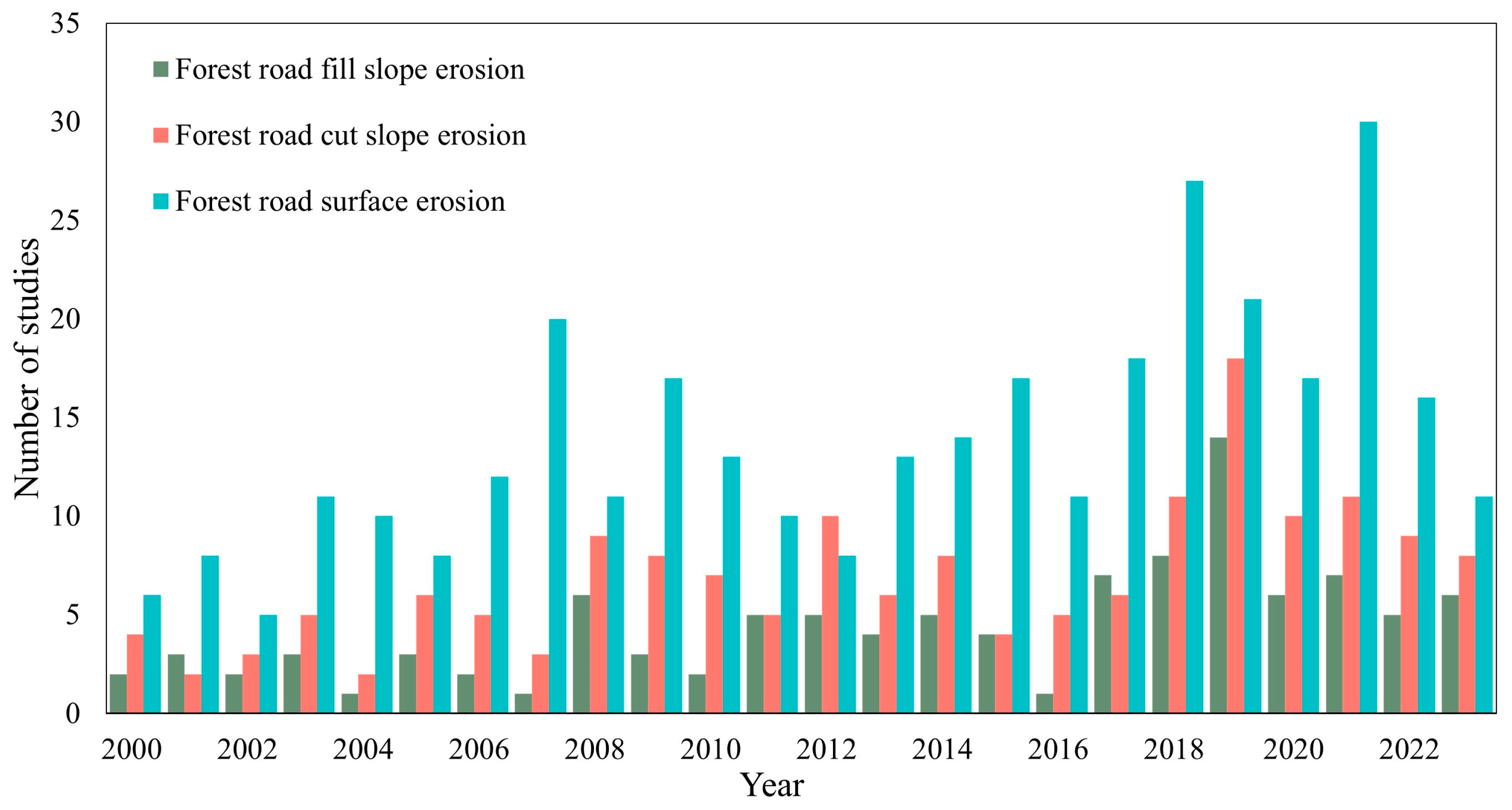
2. Mechanisms of Sediment Production from Forest Road Erosion

2.1. Road Erosion Units

Forest road prism refers to the cross-section of road structure, which typically consists of several key components, including cut slopes, road surfaces, fill slopes, side ditches, and culverts [14]. Among them, the road surface is a compacted area used to support traffic, the side ditch is a drainage structure along one side of the road, and the culvert is a conduit constructed under the road surface that delivers runoff from ditches on the upper hillslope side of a road [15,25].
Of these units, the road surface is a primary focus of forest road erosion research. Based on search results, there were 334 studies on ‘forest road surface erosion’ from 2000 to 2023 (Figure 1). Due to the compaction and fragmentation caused by pedestrian and vehicular traffic, the soil bulk density of road surfaces increases by 500–1000 kg m−3, while the porosity decreases by 10%–30%, especially with unpaved ones [26]. During rainfall, the road surface is susceptible to experiencing infiltration excess (Horton) runoff and generating concentrated runoff with high energy, which exacerbates the erosion of the road surface [27]. As a consequence, a significant amount of loose soil on road surfaces can be detached and transported by rapidly generated runoff, facilitated by extremely low infiltration rates (≤5 mm h−1) [28]. This can occur even under moderate rainfall intensities (2.5–7.6 mm h−1) [29]. In addition, a longer road surface can collect more rainfall and increase the likelihood of runoff production, while roads with larger slopes can increase the runoff hydrodynamic force, enabling runoff to erode and carry soil particles more effectively [30].
Road cut slopes are created through the excavation of slopes during road construction [31]. There were 165 studies on ‘forest road cut slope erosion’ from 2000 to 2023 (Figure 1). Researchers generally concur that cut slopes represent significant sources of sediment in road erosion [32,33]. Exposed to raindrops, runoff, and gravity, cut slopes undergo splash erosion, gully erosion, collapse, and landslides, resulting in substantial runoff and sediment erosion [31,32]. On the other hand, cut slopes notably augment surface runoff by intercepting overland flow and subsurface flow from the upper hillslope [34,35].
Road fill slopes are commonly constructed on the sides of road embankments with specific slopes to ensure roadbed stability [36]. However, the loose nature of the materials used in embankments makes them susceptible to soil erosion and landslides, which contribute significantly to sediment in road erosion [37]. As erosion progresses and gullies form, road fill slopes or the lower hillslopes may directly or indirectly connect to streams [38], intensifying the transport of eroded sediment from the road surface or cut slope to the stream [10,39].
Among the various units of the forest road prism, cut slopes consistently stand out as the major contributors to sediment yield [40,41], accounting for 70%–90% of total soil loss, followed by road surfaces, while fill slopes consistently exhibit the lowest sediment yield (as shown in Table 1 and Table 2). Consequently, current research on forest road erosion has displayed a distinct bias, predominantly emphasizing road surfaces and cut slopes while largely overlooking fill slopes and lower hillslopes. There were only 105 studies on ‘forest road fill slope erosion’ from 2000 to 2023, which is less than research on ‘forest road surface erosion’ (334) and ‘forest road cut slope erosion’ (165) (Figure 1). This imbalance can be attributed to two principal factors. Firstly, cut slopes consistently experience the most severe erosion intensity and soil degradation in comparison to other road erosion units [40]. Secondly, the sediments deposited on the fill slope mainly originate from the cut slope, road surface, and ditch, resulting in sediment that is predominantly heterogeneous [18]. Moreover, because fill slopes are connected to the lower hillslopes or the riparian zone, they are often considered part of the sediment transport pathways between roads and streams rather than being recognized as focal points for road erosion [18].
Additionally, as evident in Table 1 and Table 2, most existing studies tend to quantify erosion in specific sections or units of the road prism without considering the road erosion units as an integrated whole. For instance, Cerdà [31] found that there is a close relationship between cut slopes and road surfaces. The large amount of runoff intercepted by the cut slope will flow into the road surface, accelerating road erosion, and then the large amount of sediment generated by cut slope erosion will also deposit on the road surface. Based on element tracing, Muñoz-Arcos et al. [49] found that most of the eroded sediment on the fill slope after wildfires comes from the cut slope. In addition, Farias et al. [10] found that the concentrated high-speed runoff on the road surface can erode the fill slope, leading to an increase in the erosion intensity of the fill slope. Given the vital interplay among cut slopes, road surfaces, and fill slopes [37], it is essential to acknowledge that investigating each component in isolation falls short of providing a comprehensive understanding of road erosion mechanisms.

2.2. Factors Affecting Sediment Production of Forest Road Erosion

The process of forest road erosion is a complex spatiotemporal dynamic phenomenon. It is influenced by a combination of natural, road-related, and anthropogenic factors. Natural factors encompass rainfall and wildfires. Rainfall, in particular, is commonly regarded as a fundamental catalyst for road erosion [4,14]. Raindrops and the subsequent concentrated runoff provide the primary energy responsible for detaching and transporting soil particles [33]. It has been reported that as the rainfall intensity increased from 2.2 to 10.8 mm h−1, the average sediment concentration increased from 14.9 to 74.1 g L−1 [41]. Consequently, the sediment yield of road erosion tends to increase with higher rainfall intensity, although sediment concentration is typically highest at the onset of a rainfall event and gradually decreases thereafter [50]. Moreover, other natural elements such as wildfires have also been demonstrated to impact road erosion and sediment yield. Research has shown that road-eroded sediment yield increases by 2–15 times after wildfires [49,51]. The higher the severity of wildfires, the higher the eroded sediment yield.
Furthermore, when considering road-related factors, certain intrinsic characteristics are recognized for their influence on sediment yield across various erosion units of the road prism [52]. These factors encompass the length, slope, and surface area of roads, vegetation coverage, and soil texture. Among these factors, the catchment area defines the upper and lower bounds of runoff and sediment yield in each erosion unit, while slope and length govern the variability within these bounds [53]. Generally, the larger the catchment area or the greater the road slope, the higher the eroded sediment yield. For every 1 ha increase in the catchment area, the average eroded sediment yield increases by 40 kg ha−1 [28,36]. For every 1° increase in road slope, the eroded sediment yield increases by 0.28 kg m−2 [47]. Vegetation is expected to enhance surface soil roughness, intercept runoff, and reduce runoff energy, thereby augmenting soil cohesion and shear strength while mitigating the detachment and scouring of soil particles [31]. When the vegetation coverage is greater than 50%, the eroded sediment yield may decrease to 0 [54]. Soil texture determines the propensity for soil particles to be detached and transported, with sandy soils being more susceptible to detachment and clay soils more predisposed to transport following detachment [55,56].
Anthropogenic factors, such as traffic and production activities, tend to impede soil infiltration rates, facilitate runoff collection [30,47], and promote the development of rills and gullies [43]. However, routine road maintenance practices, including rut repair, gully clearance, gravel application, and vegetation planting, are deemed beneficial as they play a pivotal role in erosion control, effectively retarding or preventing road erosion occurrences [57].

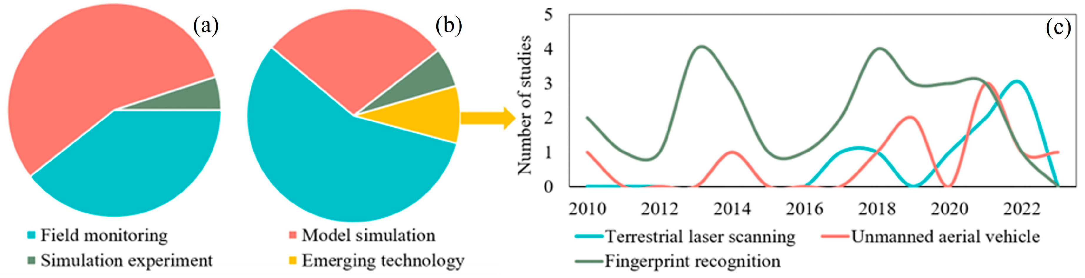
2.3. Assessing Sediment Production of Forest Road Erosion

Forest roads, being significant contributors of sediment in watersheds, exert substantial adverse effects on the eco-hydrological processes within the watershed. In order to evaluate these eco-hydrological impacts of road erosion and provide guidance for the adoption of erosion control measures, it is imperative to precisely assess and forecast sediment production resulting from road erosion [58,59]. Typically, established methods for quantifying road erosion encompass field monitoring, artificial simulation experiments, and model simulations [60].
Field monitoring is a common practice used to observe sediment yield from road surfaces, slopes, and outlets under natural rainfall conditions [20]. In the past 24 years, 354 studies have been conducted on the field monitoring of road-eroded sediment production (Figure 2). However, field monitoring is susceptible to the uncertainties of natural rainfall and road traffic, which makes it challenging to conduct on-site observations during rainfall events [61]. Artificial simulation experiments, including rainfall simulation experiments and erosion scour experiments, provide greater flexibility and efficiency in terms of experimental settings, rainfall conditions, and road characteristics [40,62]. According to search results, from 2000 to 2009, there were only five studies about artificial simulation experiments, while from 2010 to 2023, there were 33 studies. These experimental methods have experienced significant development in recent years and have gained popularity among researchers [61] (Figure 2). Nevertheless, the accuracy of results obtained through artificial simulation experiments often differs from field monitoring, and they are typically limited to small-scale studies, making their application at larger scales challenging.
The development of road erosion models has become a convenient and efficient method for quantifying road erosion [63]. There were 55 studies about model simulation from 2000 to 2009, while from 2010 to 2023, there were 158 studies (Figure 2). These models can generally be categorized into empirical models and physical models. Empirical models rely on statistical relationships between erosion quantity or intensity and contributing factors. Notable empirical models include the Washington Road Surface Erosion Model (WARSEM) [60], Revised Universal Soil Loss Equation (RUSLE) [22], Road Sediment Model (ROADMOD), Sediment Model (SEDMODL) [39], St. John’s Sediment Budget Model (STJ-EROS) [2], and Road Erosion and Delivery Index (READI) [64]. The above models can be used to evaluate and predict soil erosion and sediment yield. Among them, WARSEM, ROADMOD, and READI are mainly applied to road management and environmental protection, while RUSLE, SEDMODL, and STJ-EROS are applicable to a wider range of land management and soil and water conservation projects. In addition, different models have varying requirements for input data and model complexity. Some models (such as RUSLE) may be relatively simple, while others (such as SEDMODL and STJ-EROS) may require more input data and processing steps (as detailed in Table 3). Physical models are based on mass or energy conservation equations that describe erosion and sediment transport processes, derived from hydrological response models simulating infiltration and runoff pathways [65]. Prominent physical models include the Water Erosion Prediction Project model (WEPP) [57], the Kinematic Runoff and Erosion Model (KINEROS2) [66], and the Distributed Hydrology Soil Vegetation Model (DHSVM) [67]. These models have been widely applied to roads in various specific landscape contexts, particularly forest roads. WEPP and KINEROS2 are relatively simple and require less input data. In contrast, DHSVM requires more input data and processing steps, including terrain data, soil properties, and vegetation types. The model complexity is relatively high and requires strong technical support. Due to the emphasis on different structures, parameters, and applicability, these models exhibit significant differences [58] (as detailed in Table 3). When selecting a model for simulating forest road erosion and sediment transport, it is crucial to consider whether the model is suitable for the forest road erosion processes and characteristics in the study area, as well as whether the parameter values are appropriately applied in the modeling process [68].
In recent years, some emerging technologies like terrestrial laser scanning (TLS), unmanned aerial vehicle (UAV) imaging, and fingerprint recognition have found widespread use in both field monitoring and artificial simulation experiments [69]. There were 48 studies about emerging technologies from 2010 to 2023 (Figure 2). Among these technologies, TLS enables the rapid and precise acquisition of soil erosion information [35], UAV images aid in generating digital road surface models (DSM) [70], and fingerprint recognition can assess the relative importance and contribution of forest roads as a sediment source in a watershed [71]. These innovative approaches effectively enhance work efficiency and convenience, address the difficulties of traditional methods and tools in large-scale applications, and gradually become effective means of accurately describing erosion patterns and providing spatial representations [72]. In summary, despite being costly and time-consuming [61], field monitoring and simulation experiments represent effective approaches to understanding the mechanisms of road erosion, assessing erosion intensity, and optimizing model parameters and performance [73].

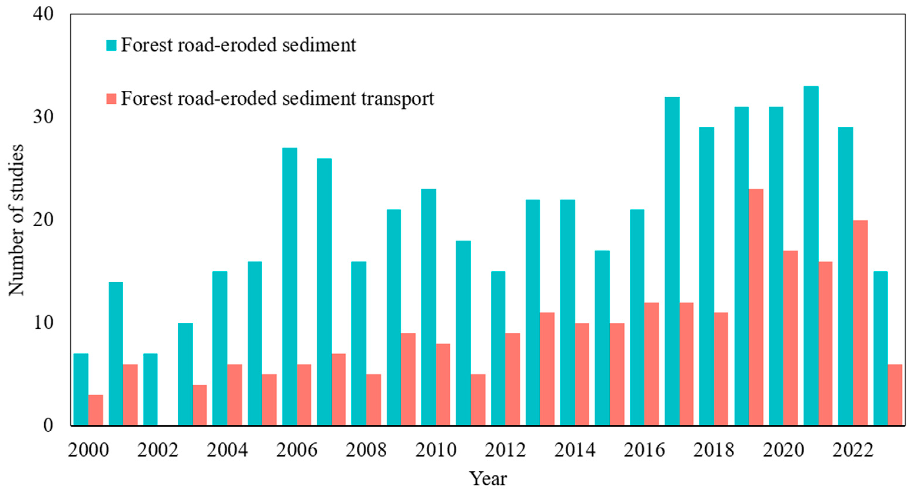
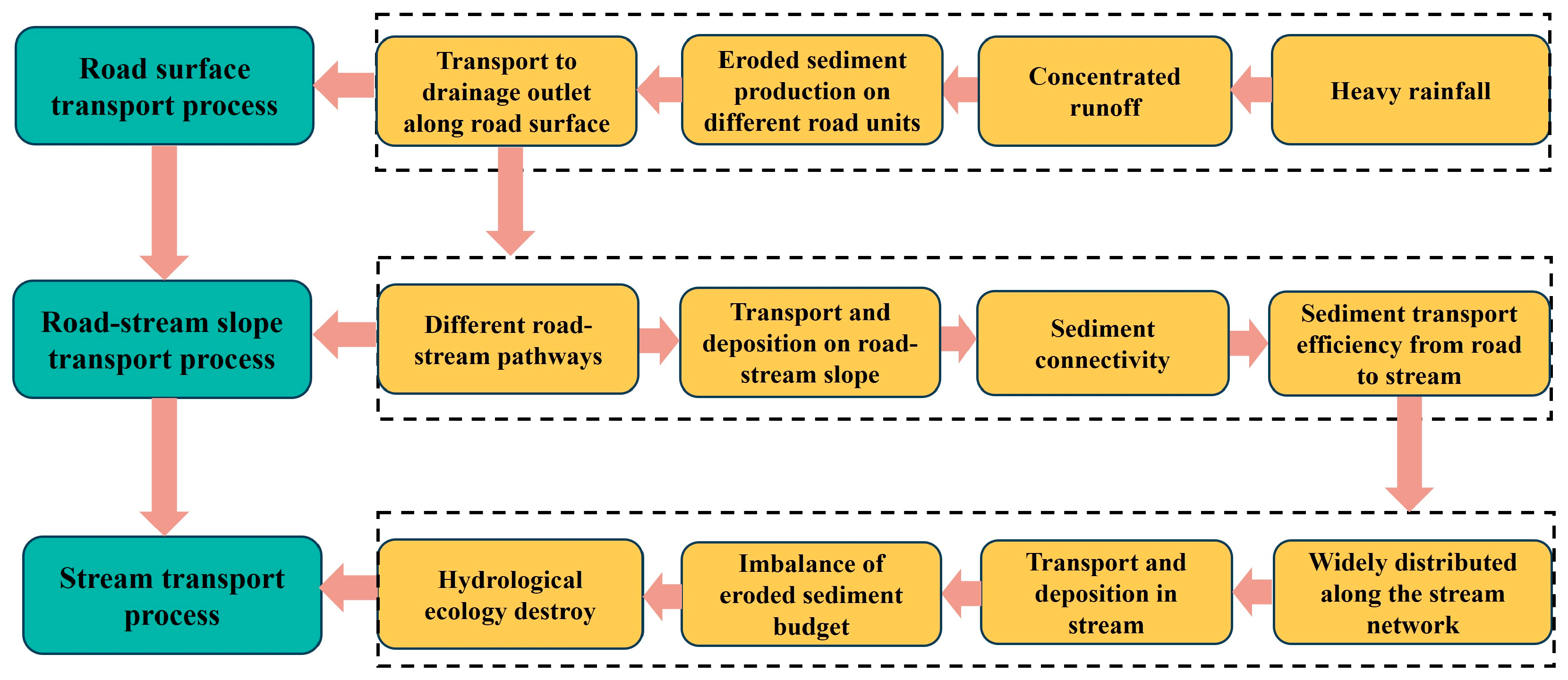
3. The Transport Mechanisms of Forest Road-Eroded Sediment

The occurrence of road erosion and the transport of eroded sediment are intimately connected processes. When runoff erodes the road surface and produces sediment, it invariably leads to the transportation of sediment via runoff [64]. The transport of eroded sediment is crucial for understanding the off-site effects of road erosion and is closely related to the aquatic ecological security of the watershed [24].
Current research on forest road erosion and sediment production is comprehensive and specific, while research on eroded sediment transport is relatively lagging and lacking. We found that there were 497 studies related to ‘forest road erosion sediment’ within 24 years, while there were only 221 studies related to ‘forest road-eroded sediment transport’ (Figure 3). The number of studies on forest road erosion is still increasing, which means that related research is still being further improved. It is worth noting that although the number of studies on forest road-eroded sediment transport is less than half of that on forest road erosion, it is increasing year by year. The number of studies conducted between 2012 and 2023 (157) is 2.45 times that between 2000 and 2011 (64), indicating that the transport of forest road-eroded sediment is receiving attention [7,14], but there is still a certain gap compared to research on forest road erosion. Therefore, it is necessary to explore the transport mechanism of road-eroded sediment.
Research indicates that the conveyance of road-eroded sediment predominantly relies on rainfall runoff as its carrier [8]. Driven by runoff forces, sediment enters the stream network through various transport pathways, consequently disrupting the balance of the sediment budget and impacting aquatic ecosystems [74]. It is worth noting that while nearly all unpaved road surfaces are susceptible to erosion, not all the eroded sediment finds its way into streams. This is because sediment and other materials may be deposited or intercepted in their original positions or between drainage ditches and streams [2].
Previous studies have made use of the sediment delivery ratio (SDR) related to the watershed area [74], which typically converts the estimated soil erosion quantities from the model directly into sediment transport quantities [75]. However, due to the spatiotemporal variability of factors governing sediment transport and storage, it is inaccurate to proportionally convert forest road-induced soil erosion into watershed sediment discharge [76]. Generally, the transport processes of forest road-eroded sediment can be decomposed into three distinct phases: the road surface transport process [77], the road–stream slope transport process [16], and the stream transport process upon entering the stream network [65]. Therefore, we delve into the specific mechanisms and inherent interconnections of these three transport processes (Figure 4).

3.1. Transport Process of Eroded Sediment on Forest Road Surfaces

The road surface serves not only as a source area for eroded sediment but also as a vital pathway for transporting sediment-laden runoff [48]. The road surface transport process generally involves the transportation of eroded sediment along the road surface to the drainage outlet, which includes both in situ sediment and sediment from the upper hillslope and cut slope [64]. Due to the high compaction of forest road surfaces, the infiltration rate is mostly less than 5 mm h−1 [34]. During rainfall, only 3 to 6 mm of rainfall can generate excessive surface runoff from forest roads [2,19]. In addition, the road surface intercepts runoff from the upper hillslope and accelerates the generation and accumulation of runoff to transport sediment [25,28]. An interesting study showed that runoff coefficients for gravel road surface at 1, 3, and 7% slopes were 0.60, 0.65, and 0.68, while runoff coefficients for cobblestone at 1, 3, and 7% slopes were 0.41, 0.45, and 0.47, respectively [78]. Consequently, the characteristics of the road surface and the road’s morphology play a pivotal role in the sediment transport process [79].
Concerning unpaved forest roads, studies have indicated that, under the influence of rainfall and traffic, bare road surfaces are more prone to forming rills or gullies in comparison to graveled road surfaces [56]. It has been reported that the sediment delivery rate on bare forest roads ranges from 34 to 287 t ha−1 yr−1, while that on graveled forest roads falls within the range of 10 to 16 t ha−1 yr−1 [42]. Furthermore, research has shown that concave road surfaces tend to concentrate runoff, thereby accelerating sediment transport to road drainage outlets [23]. In contrast, flat road surfaces typically disperse runoff, reducing the hydrodynamic force involved in sediment transport [50].

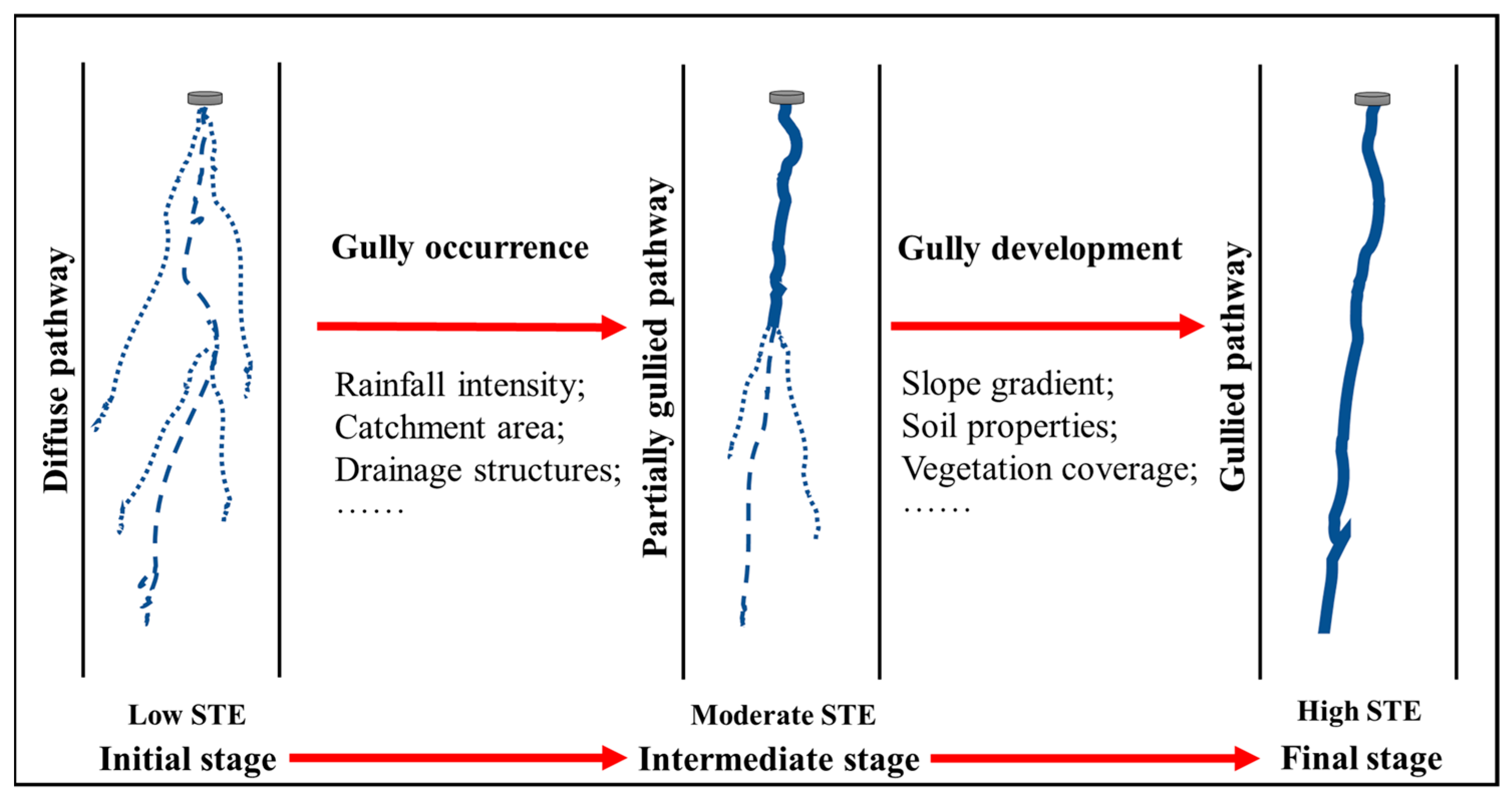
3.2. Transport Process of Eroded Sediments on Forest Road–Stream Slopes

3.2.1. Sediment Transport Mechanisms

Once discharged from the road surface, sediment-laden runoff proceeds downhill toward the stream, initiating slope erosion and the creation of sediment transport routes connecting the road to the stream [15]. Typically, these established sediment transport pathways can be classified into three main categories: diffuse pathways, gully pathways, and partially gullied pathways (Figure 5) [16].
The diffuse pathways are generally found on lower hillslopes that have not been significantly eroded by road runoff. They consist of a primary runoff plume and multiple dendritic plumes and lack well-defined channels or gullies, but some rills smaller than 5 cm can be observed [50]. Influenced by the interception and infiltration effects of surface soil, vegetation, and litter layers, sediment-laden runoff in the diffuse pathway is typically dispersed with weak hydrodynamic force and sediment-laden capacity [15,16]. As a result, the diffuse pathway is seldom observed to extend beyond 30 m on vegetated slopes [80] (Table 4), making it challenging for sediment-laden runoff discharged from road drains to reach streams when the distance from the road to the stream is considerable. Consequently, diffuse pathways have the lowest sediment transport efficiency among the three categories of pathways, and the transport process on diffuse pathways is deposition-dominated [81].
The gully pathway is defined as a channelized route formed due to gully erosion on the road–stream slopes, which is characterized by a depth greater than 30 cm or a cross-sectional area greater than 0.09 m2 [21]. It is reported that the formation of gully pathways is a threshold-controlled process influenced by various factors such as topography, rainfall, hydraulic conditions, soil lithology, and land use [70]. The concept of a threshold based on slope–area (S-A) has been widely used to explain the formation of gully pathways [82]. Research has shown that the critical topographic thresholds for the initiation of the gully pathways and the continued development of gullies from partial to complete gully pathways could be expressed as Ds = 0.35Eca−0.13 and Ds = 0.41Eca−0.17, respectively, where Ds represents the slope gradient of lower hillslope and Eca represents the effective contribution area [16]. Furthermore, changes in vegetation or land use can alter the formation threshold of gully pathways by modifying effective rainfall intensity and runoff characteristics [16], making gully pathways more likely to occur on slopes with roads [38]. According to MacDonald and Coe [23], 9% to 35% of roads are directly or indirectly connected to streams through gully pathways, with an average sediment transport distance of 86 m [73] (Table 4). This connection not only alters hydraulic gradients, drainage density, and flow pathways but also redistributes sediment-laden runoff, intensifying sediment transport [83]. Therefore, the gully pathway has the highest sediment transport efficiency among the three categories of pathways [84].
The partially gullied pathway represents the intermediate stage in the transformation from a diffuse pathway into a gully pathway. It is characterized by gullies that initially form with rill formation and further develop on the lower slope but do not reach the streams due to factors such as reduced hydrodynamic force or the influence of topography, soil, and vegetation [73]. Consequently, the partially gullied pathway exhibits characteristics of both gully pathways and diffuse pathways, which has an average sediment transport distance between gully pathways and diffuse pathways and a moderate capacity to connect roads and streams [15] (Table 4).
The formation of transport pathways on road–stream slopes is closely related to factors like rainfall intensity, road drainage structures, and slope hydrodynamic force [16], which interact in space and time, collectively determining the formation and transport efficiency of the three types of pathways mentioned above. Furthermore, the formation of gullies is typically irreversible, as they enhance connectivity between roads and stream networks, enabling more road-eroded sediment to enter stream networks along the transport pathways on slopes [85].

3.2.2. Sediment Connectivity between Roads and Streams

The sediment connectivity quantifies the sediment transport ratio from the erosion unit to the watershed outlet [86,87]. Currently, sediment connectivity has become a central focus in soil erosion research, particularly concerning the source–sink relationships of sediment within watersheds [88]. By employing the concept of sediment connectivity, researchers can diagnose and quantify sediment transport pathways and their spatiotemporal variations [89]. This understanding allows for the identification of key road segments as sediment sources and priority areas for soil and water conservation, facilitating the prevention and control of sediment transport from roads to streams and the maintenance of watershed ecological security [24]. Therefore, comprehending the mechanisms of sediment connectivity between roads and streams is pivotal for mitigating the off-site effects of road erosion [90,91].
The road–stream slope serves as the principal transport pathway for road-eroded sediment [34]. It is reported that over two-thirds of road-eroded sediment can be transported to streams via road–stream pathways [92]. These pathways exhibit varying degrees of sediment connectivity between roads and streams, influencing the transport efficiency of sediment-laden runoff [24]. Generally, the connectivity of gully pathways is significantly higher than that of partially gullied pathways and diffuse pathways [15]. This is primarily because the development of gullies provides direct channels for the convergence of slope runoff and sediment transport, directly connecting roads and streams [93,94].
Furthermore, research has shown that when sediment-laden runoff is transported along diffuse pathways through road drainage outlets, the runoff and sediment load are significantly reduced (Table 4). Compared with gully pathways, diffuse pathways disperse concentrated runoff, increase runoff infiltration, and promote sediment deposition [95]. This is largely attributed to the disturbance of vegetation along the diffuse pathways, which reduces road–stream connectivity [54]. A study in Thailand has proved that the natural vegetation distributed along the stream bank blocked the connection between the road and stream, and the sediment concentration decreased by 34%–87% during rainstorms [96].
It has been reported that rainfall intensity is the main controlling factor for road–river connectivity [34,97]. In general, an increase in rainfall intensity or road erosion intensity directly leads to a rise in sediment connectivity [85,87], inevitably resulting in increased sediment transport from roads to streams. For instance, in a study by Crokea et al. [73], it was found that the maximum travel distance of sediment-laden runoff in a diffuse pathway ranged from 16 to 25 m in a 10-year return rainfall event and extended to 28~42 m in a 100-year return rainfall event. Additionally, the development and expansion of road–stream pathways have shortened the length of runoff pathways, increased the cumulative amount of runoff, and increased the accessibility index and sediment connectivity [61], providing more opportunities and possibilities for sediment transport.
Accurate measurement of sediment connectivity is crucial [98]. Although there have been many studies on sediment connectivity, quantitative measurements and research methods of sediment connectivity for different pathways between roads and streams are still limited. In the past, the earliest indicator used to quantify the connectivity between roads and streams was the sediment delivery ratio (SDR) [74]. Subsequently, researchers like Burak [36] quantified the connectivity of road–stream pathways in forests using the density and discharge of road network drainage outlets. Cavalli et al. [99] modified the Index of Connectivity (IC) proposed by Borselli et al. [100] to assess the potential linkages between road sediment source areas, major stream networks, and watershed outlets. Thompson et al. [78] and Benda et al. [64] developed the Road Connectivity Assessment Tool (RoadCAT) and Road Erosion and Delivery Index (READI) model based on the concepts of volume breakthrough and connectivity between forest roads and streams to determine different types of transport pathways on hillslopes and estimate the sediment transport through these pathways, respectively.
To sum up, from the perspective of sediment connectivity, targeted management measures should be considered to reduce sediment connectivity, such as restricting gully development and adding buffer zones [21,85], to mitigate the off-site effects of road erosion, specifically sediment transport through road–stream pathways. However, there is still a significant research gap in this area at present.

3.3. Transport Process of Forest Road-Eroded Sediment in Streams and Its Ecological Effects

Generally, once road-eroded sediment enters the stream networks of a watershed, it undergoes transport and deposition with stream flow, which has a detrimental impact on the aquatic ecology of the watershed [65].
The transport of sediment in stream networks is significantly influenced by the hydrodynamic forces of the stream, such as the flow velocity [65]. It has been reported that higher flow velocity or discharge makes eroded sediment more likely to undergo long-distance transport [101], resulting in widespread distribution throughout the watershed. Furthermore, narrower channels facilitate the rapid transport of eroded sediment under high flow velocity and discharge conditions, while sedimentation is more likely to occur under conditions of low flow velocity and discharge [102].
In addition to the hydrodynamic forces of the stream, the deposition and transport of forest road-eroded sediment in the stream network are closely related to the size of sediment particles. Generally, coarse sediments (particle size > 2 mm) tend to deposit on the stream bed throughout the stream network [103]. This significantly raises the stream bed and alters the composition of sediment particles, negatively impacting the spawning environment of aquatic organisms. On the other hand, fine sediments (particle size < 2 mm) are typically suspended in stream flow [103], leading to increased water turbidity, which in turn inhibits the photosynthesis of aquatic plants, damages stream habitats and food web structures, and affects the migration, survival, and species richness of aquatic organisms [104]. Therefore, road-eroded fine sediments often pose greater harm over longer time scales compared to coarse sediments. It is important to emphasize that natural disasters such as floods, collapses, landslides, and debris flows often accompany road erosion [85]. These disasters further exacerbate the harm caused by road erosion to the watershed ecosystem. Hence, targeted control measures should be implemented to prevent such damages.
In reality, it is the complexity of the forest road–stream–watershed sediment transport system that makes the estimation of sediment transport and deposition in streams so challenging [105]. Due to the difficulty in accurately predicting the concentration of road-eroded sediment in streams over various time scales, we still lack a comprehensive understanding of how the different driving factors of erosion transport interact in space and time.

4. Regulation of Forest Road Erosion and Sediment Transport

Road-eroded sediment has been demonstrated to inflict significant harm on both terrestrial and aquatic ecosystems [73]. To tackle this issue, various measures designed to mitigate road erosion and sediment transport have been developed. According to best management practices (BMPs), these measures can be categorized into engineering measures and biological measures [57,106,107].
Engineering measures typically involve road structures and auxiliary facilities, including cut slope intercept trenches, drainage ditches on road surface, and silt fences for cut slope [106,107]. They also encompass gravel pavement [108], hardwood slash [107], check dams [109], detention ponds [110], and sedimentation basins [111]. It is evident that engineering measures can significantly reduce road-eroded sediment production and transport during rainfall events (Table 5). Among them, gravel pavements help to reduce sediment erosion, while sediment ponds are the most effective measure to reduce the transport of sediment from roads to streams, with an average reduction rate of 92.5%. On the other hand, biological measures involve biotechnical approaches, particularly vegetation restoration, to enhance runoff infiltration and impede the transport of sediment [112]. Some common biological measures currently employed include sowing grass seeds, planting shrubs [113], mulching erosion control mats [114], and geotextiles [115], all of which have been shown to have a significant impact on reducing sediment erosion and transport (Table 5). Among them, erosion control mats are the most effective measure, with an average sediment reduction rate of 91.67%, while vegetation planting can not only reduce sediment erosion but can also effectively intercept sediment and reduce its transport from roads to streams.
Both engineering measures and biological measures can effectively reduce sediment production, with an average sediment reduction rate of 75.96% and 80.22%, respectively (Table 5). Compared to engineering measures, biological measures are generally more effective [116]. Furthermore, biological measures are also characterized by simplicity, lower costs, higher landscape value, and sustainability over the long term. Therefore, when managing and regulating forest roads, priority should be given to biological measures. Additionally, studies have shown that a combination of engineering measures and biological measures can achieve better effectiveness in mitigating road erosion and the transport of road-eroded sediment [117], but the economic benefits are not yet clear.

5. Prospectives

It is evident that previous studies have made significant contributions to understanding the mechanisms of road-eroded sediment production, the transport process of eroded sediment, and the measures for preventing and controlling sediment transport. These studies have provided valuable insights into the understanding of sediment transport both on-site and off-site within the forest road prism. However, we believe that several aspects still require further research and investigation.
Firstly, with regard to the research focus on forest road erosion, most studies primarily concentrate on either the erosion characteristics of a specific unit of the road prism or are at the road section scale; they rarely consider the entire road prism as a whole to explore the mechanism of eroded sediment production. Moreover, sediment production and transport processes in road erosion are often studied and discussed separately, which limits the in-depth understanding of the off-site effects caused by road erosion within the watershed. Therefore, we suggest that future research should pay attention to the interrelationships between various road erosion units by exploring the sediment production characteristics of different erosion units on forest roads. At the same time, the road prism should be regarded as a whole system of eroded sediment production within the watershed, and further investigation should explore the water sediment transport from the linear road network to the watershed based on the eroded sediment production process.
Secondly, in terms of research methods for forest road erosion, most studies rely on artificial simulation experiments rather than field monitoring. However, simulation experiments are often based on overly idealized or hypothetical conditions, resulting in significant discrepancies in results compared to field monitoring. Additionally, the emergence and development of road erosion models have opened up new possibilities. While these models have demonstrated impressive performance at the watershed scale, variations in modeling parameters, empirical factors, research perspectives, and regions make different models regionally specific and challenging to apply universally. Therefore, we recommend that field monitoring should integrate new technologies such as fingerprint recognition and laser scanning to enhance work efficiency and accurately quantify sediment yield and transport in road erosion. Based on a substantial amount of field monitoring data, the setup conditions for artificial simulation experiments can be improved to better align with natural scenarios. On this foundation, the forest road erosion prediction models can be refined by adjusting model parameters to enhance their accuracy and applicability.
Furthermore, concerning the research on forest road-eroded sediment transport, almost all studies have concentrated on the transport of eroded sediment within the road prism, neglecting the sediment transport processes taking place on the road–stream slope, which include detachment and deposition. Nevertheless, the transport process of sediment on the road–stream slope is crucial for exploring the off-site effects of road erosion. This process directly influences how much road-eroded sediment can enter the stream and the associated ecological effects. Therefore, it is essential to address the gaps and shortcomings in the research on sediment transport at the slope scale, particularly from the perspective of connectivity. Sufficient exploration of sediment transport and hydrological processes between roads and streams is necessary. Specifically, field monitoring should be carried out at road drainage outlets, transport pathways, and stream entrances to obtain accurate and effective water sediment transport data on road–stream slopes. Additionally, the spatiotemporal dynamics of water sediment transport and the factors influencing connectivity between roads and streams should be identified through field investigations or artificial simulation experiments. On this foundation, connectivity indices, such as IC, can be introduced and improved to quantify the interaction between roads and streams. A comprehensive understanding of the inherent connections of sediment transport processes across various scales is also necessary and plays a crucial role in studying road-eroded sediment transport and understanding and applying sediment connectivity.
Finally, regarding the regulation of forest road erosion, two aspects should be considered: one is controlling the yield of eroded sediment from road erosion sources and the other is reducing sediment transport based on the principle of connectivity. Currently, regulation measures for road erosion are primarily proposed and implemented to reduce erosion and intercept sediment transport within the road prism, with limited emphasis on sediment connectivity between roads and streams. However, the road–stream slope serves as not only a necessary passage in the transport of eroded sediment but also the final link for road-eroded sediment to enter streams. Therefore, the focus on regulating forest road erosion should be adjusted, and it is essential to implement measures such as planting vegetation, constructing sedimentation basins, establishing buffer zones, and introducing other regulatory measures on road–stream slopes. Furthermore, integrating road erosion control concepts into road construction processes to proactively protect roads from erosion and adopting a combination of engineering and biological measures could help limit or reduce the production and transport of sediment. Moreover, the development of specific regulatory measures based on the unique conditions of the research area not only aids in fully utilizing road functions but also prevents soil erosion and protects the ecological security of the watershed. Simultaneously, it is essential to further explore the economic costs and ecological benefits of implementing these regulatory measures.

6. Conclusions

The severe environmental impact of forest road erosion is receiving increased recognition, leading to extensive research efforts in this field. Significant progress has been made in understanding the mechanisms behind eroded sediment production, with a comprehensive and specific grasp of the underlying processes. Furthermore, research methods continue to evolve and advance to meet new research objectives. In comparison, there is a need for enhanced research into the transport processes of forest road-eroded sediment. This aspect is pivotal in uncovering the off-site effects of forest road erosion and understanding the adverse consequences of eroded sediment transport on the ecological and hydrological balance of watersheds. Therefore, the research on road erosion sediment transport and regulation is the most promising. Driven by this demand, sediment transport processes have been subject to qualitative and quantitative analysis. Notably, the introduction and application of sediment connectivity have significantly contributed to the investigation of sediment transport processes, offering insights into strategies for reducing and mitigating road erosion and sediment transport. While engineering and biological regulatory measures for controlling forest road erosion and sediment transport have been proposed and implemented, there is room for further exploration of cost-effective and efficient solutions. The combination of engineering and biological measures is more effective in reducing the negative impact of road erosion. This research is summarized and discussed based on the aforementioned aspects, with the aim of providing essential knowledge for reducing the production and transport of forest road-eroded sediment to streams. Future research should still focus on the regulation of eroded sediment, as well as the interception of sediment before entering rivers, which can help improve the global environmental problem of road erosion.

Author Contributions

Conceptualization, Q.Z. and S.D.; methodology, J.Y. and Z.Y.; software, J.Y. and Y.L.; validation, J.Y., Y.L. and Z.Y.; formal analysis, J.Y.; investigation, J.Y.; resources, J.Y.; data curation, J.Y.; writing—original draft preparation, J.Y.; writing—review and editing, Q.Z.; visualization, J.Y.; supervision, Q.Z. and S.D.; project administration, Q.Z. and S.D.; funding acquisition, Q.Z. and S.D. All authors have read and agreed to the published version of the manuscript.

Funding

This research was funded by the National Natural Science Foundation of China (41971229), Natural Science Foundation of Henan Province (202300410050), Program for Science and Technology Innovation Talents in Universities of Henan Province (22HASTIT013), and Xinyang Academy of Ecological Research Open Foundation (2023DBS01, 2023XYZD03).

Data Availability Statement

Not applicable.

Acknowledgments

We would like to thank Daniel Petticord at the University of Cornell for his assistance with the English language and grammatical editing of the manuscript.

Conflicts of Interest

The authors declare no conflicts of interest.

References

  1. Sosa-Pérez, G.; MacDonald, L.H. Reductions in road sediment production and road-stream connectivity from two decommissioning treatments. For. Ecol. Manag. 2017, 398, 116–129. [Google Scholar] [CrossRef]
  2. Ramos-Scharron, C.E.; Macdonald, L.H. Runoff and suspended sediment yields from an unpaved road segment, St John, US Virgin Islands. Hydrol. Process. 2007, 21, 35–50. [Google Scholar] [CrossRef]
  3. Wang, C.M.; Liu, B.Y.; Yang, Q.K.; Pang, G.W.; Long, Y.Q.; Wang, L.; Cruse, R.M.; Dang, W.Q.; Liu, X.; Wang, E.H. Unpaved road erosion after heavy storms in mountain areas of northern China. Int. Soil Water Conserv. Res. 2022, 10, 29–37. [Google Scholar] [CrossRef]
  4. Cao, L.; Zhang, K.; Dai, H.; Liang, Y. Modeling interrill erosion on unpaved roads in the loess plateau of China. Land Degrad. Dev. 2015, 26, 825–832. [Google Scholar] [CrossRef]
  5. Rijsdijk, A.; Bruijnzeel, L.; Sutoto, C.K. Runoff and sediment yield from rural roads, trails and settlements in the upper Konto catchment, East Java, Indonesia. Geomorphology 2007, 87, 28–37. [Google Scholar] [CrossRef]
  6. Ramos-Scharrón, C.E. Land disturbance effects of roads in runoff and sediment production on dry-tropical settings. Geoderma 2018, 310, 107–119. [Google Scholar] [CrossRef]
  7. Sidle, R.C.; Ziegler, A.D. The dilemma of mountain roads. Nat. Geosci. 2012, 5, 437–438. [Google Scholar] [CrossRef]
  8. Eisenbies, M.H.; Aust, W.M.; Burger, J.A.; Adams, M.B. Forest operations, extreme flooding events, and considerations for hydrologic modeling in the Appalachians—A review. For. Ecol. Manag. 2007, 242, 77–98. [Google Scholar] [CrossRef]
  9. Labrière, N.; Locatelli, B.; Laumonier, Y.; Freycon, V.; Bernoux, M. Soil erosion in the humid tropics: A systematic quantitative review. Agric. Ecosyst. Environ. 2015, 203, 127–139. [Google Scholar] [CrossRef]
  10. Farias, T.R.L.; Medeiros, P.H.A.; Araújo, J.C.D.; Navarro-Hevia, J. The role of unpaved roads in the sediment budget of a semiarid mesoscale catchment. Land Degrad. Dev. 2021, 32, 5443–5454. [Google Scholar] [CrossRef]
  11. Bartley, R.; Bainbridge, Z.T.; Lewis, S.E.; Kroon, F.J.; Wilkinson, S.N.; Brodie, J.E.; Silburn, D.M. Relating sediment impacts on coral reefs to watershed sources, processes and management: A review. Sci. Total Environ. 2014, 468–469, 1138–1153. [Google Scholar] [CrossRef] [PubMed]
  12. Vanacker, V.; von Blanckenburg, F.; Govers, G.; Molina, A.; Poesen, J.; Deckers, J.; Kubik, P. Restoring dense vegetation can slow mountain erosion to near natural benchmark levels. Geology 2007, 35, 303–306. [Google Scholar] [CrossRef]
  13. Vrieling, A. Satellite remote sensing for water erosion assessment: A review. Catena 2006, 65, 2–18. [Google Scholar] [CrossRef]
  14. Yousefi, S.; Moradi, H.; Boll, J.; Schönbrodt-Stitt, S. Effects of road construction on soil degradation and nutrient transport in Caspian Hyrcanian mixed forests. Geoderma 2016, 284, 103–112. [Google Scholar] [CrossRef]
  15. Fu, B.; Newham, L.T.; Ramos-Scharron, C. A review of surface erosion and sediment delivery models for unsealed roads. Environ. Model. Softw. 2010, 25, 1–14. [Google Scholar] [CrossRef]
  16. Wang, A.; Zhao, Q.; Yu, Z.; Yu, J.; Liu, Y.; Wang, P.; Zhang, G.; Zhou, J.; Ding, S. Factors and thresholds determining sediment delivery pathways between forest road and stream in mountainous watershed. Catena 2023, 224, 106976. [Google Scholar] [CrossRef]
  17. Zhao, Q.; Wang, A.; Jing, Y.; Zhang, G.; Yu, Z.; Yu, J.; Liu, Y.; Ding, S. Optimizing management practices to reduce sediment connectivity between forest roads and streams in a mountainous watershed. Remote Sens. 2022, 14, 4897. [Google Scholar] [CrossRef]
  18. Scharrón, C.E.R.; Alicea, E.E.; Sánchez, Y.F.; LaFevor, M.C.; McLaughlin, P.; MacDonald, L.H.; Reale-Munroe, K.; Thomaz, E.L.; Ríos, R.V. Three decades of road and trail runoff and erosion work in the northeastern Caribbean—A research program perspective. J. ASABE 2023, 66, 35–45. [Google Scholar] [CrossRef]
  19. Macdonald, L.H.; Sampson, R.W.; Anderson, D.M. Runoff and road erosion at the plot and road segment scales, St John, US Virgin Islands. Earth Surf. Process. Landf. 2001, 26, 251–272. [Google Scholar] [CrossRef]
  20. Seutloali, K.E.; Reinhard Beckedahl, H. A review of road-related soil erosion: An assessment of causes, evaluation techniques and available control measures. Earth Sci. Res. J. 2015, 19, 73–80. [Google Scholar] [CrossRef]
  21. Croke, J.C.; Hairsine, P.B. Sediment delivery in managed forests: A review. Environ. Rev. 2006, 14, 59–87. [Google Scholar] [CrossRef]
  22. Mahoney, D.; Blandford, B.; Fox, J. Coupling the probability of connectivity and RUSLE reveals pathways of sediment transport and soil loss rates for forest and reclaimed mine landscapes. J. Hydrol. 2021, 594, 125963. [Google Scholar] [CrossRef]
  23. MacDonald, L.H.; Coe, D.B. Road sediment production and delivery: Processes and management. In Proceedings of the First World Landslide Forum, International Programme on Landslides and International Strategy for Disaster Reduction, Tokyo, Japan, 17–21 November 2008; United Nations University: Tokyo, Japan, 2008; pp. 381–384. [Google Scholar]
  24. Jing, Y.; Zhao, Q.; Lu, M.; Wang, A.; Yu, J.; Liu, Y.; Ding, S. Effects of road and river networks on sediment connectivity in mountainous watersheds. Sci. Total Environ. 2022, 826, 154189. [Google Scholar] [CrossRef] [PubMed]
  25. Orndorff, A.; Hochmuth, G.; Ogram, A. Evaluating the Effects of Sedimentation from Forest Roads: A Review; Soil and Water Science Department, University of Florida: Gainesville, FL, USA, 2017; Volume 38. [Google Scholar]
  26. Alvis, A.D.; Luce, C.H.; Istanbulluoglu, E. How does traffic affect erosion of unpaved forest roads? Environ. Rev. 2022, 13, 182–194. [Google Scholar] [CrossRef]
  27. Reid, L.M.; Dunne, T. Sediment production from forest road surfaces. Water Resour. Res. 1984, 20, 1753–1761. [Google Scholar] [CrossRef]
  28. Ramos-Scharrón, C.E.; Lafevor, M.C. The role of unpaved roads as active source areas of precipitation excess in small watersheds drained by ephemeral streams in the Northeastern Caribbean. J. Hydrol. 2016, 533, 168–179. [Google Scholar] [CrossRef]
  29. Zhao, Q.; Wang, A.; Yu, Z.; Yu, J.; Liu, Y.; Zhang, G.; Liu, G.; Wang, P.; Ding, S. Factors contributing to rill erosion of forest roads in a mountainous watershed. J. Environ. Manag. 2023, 326, 116829. [Google Scholar] [CrossRef] [PubMed]
  30. Zhang, Y.; Zhao, Y.; Liu, B.; Wang, Z.; Zhang, S. Rill and gully erosion on unpaved roads under heavy rainfall in agricultural watersheds on China’s Loess Plateau. Agric. Ecosyst. Environ. 2019, 284, 106580. [Google Scholar] [CrossRef]
  31. Cerdà, A. Soil water erosion on road embankments in eastern Spain. Sci. Total Environ. 2007, 378, 151–155. [Google Scholar] [CrossRef]
  32. Arnaez, J.; Larrea, V.; Ortigosa, L. Surface runoff and soil erosion on unpaved forest roads from rainfall simulation tests in northeastern Spain. Catena 2004, 57, 1–14. [Google Scholar] [CrossRef]
  33. Chehlafi, A.; Kchikach, A.; Derradji, A.; Mequedade, N. Highway cutting slopes with high rainfall erosion in Morocco: Evaluation of soil losses and erosion control using concrete arches. Eng. Geol. 2019, 260, 105200. [Google Scholar] [CrossRef]
  34. Kastridis, A. Impact of forest roads on hydrological processes. Forests 2020, 11, 1201. [Google Scholar] [CrossRef]
  35. Cao, L.; Wang, Y.; Liu, C. Study of unpaved road surface erosion based on terrestrial laser scanning. Catena 2021, 199, 105091. [Google Scholar] [CrossRef]
  36. Burak, A. Using remote sensing data to predict road fill areas and areas affected by fill erosion with planned forest road construction: A case study in Kastamonu Regional Forest Directorate (Turkey). Environ. Monit. Assess. 2015, 187, 1–10. [Google Scholar]
  37. Solgi, A.; Naghdi, R.; Zenner, E.K.; Hemmati, V.; Behjou, F.K.; Masumian, A. Evaluating the effectiveness of mulching for reducing soil erosion in cut slope and fill slope of forest roads in Hyrcanian forests. Croat. J. For. Eng. 2021, 42, 259–268. [Google Scholar] [CrossRef]
  38. Nyssen, J.; Poesen, J.; Moeyersons, J.; Luyten, E.; Veyret, M.; Deckers, J.; Haile, M.; Govers, G. Impact of road building on gully erosion risk: A case study from the northern Ethiopian highlands. Earth Surf. Process. Landf. 2002, 27, 1267–1283. [Google Scholar] [CrossRef]
  39. Naghdi, R.; Dalir, P.; Gholami, V.; Pourghasemi, H.R. Modeling of sediment generation from forest roads employing SEDMODL and its calibration for Hyrcanian forests in northern Iran. Environ. Earth Sci. 2017, 76, 414. [Google Scholar] [CrossRef]
  40. Jordan, A.; Martínez-Zavala, L. Soil loss and runoff rates on unpaved forest roads in southern Spain after simulated rainfall. For. Ecol. Manag. 2008, 255, 913–919. [Google Scholar] [CrossRef]
  41. Sisakht, S.R.; Majnounian, B.; Saravi, M.M.; Abdi, E.; Surfleet, C. Impact of rainfall intensity and cutslope material on sediment concentration from forest roads in northern Iran. iForest 2013, 7, 48–52. [Google Scholar] [CrossRef]
  42. Brown, K.R.; Aust, W.M.; Mcguire, K.J. Sediment delivery from bare and graveled forest road stream crossing approaches in the Virginia Piedmont. For. Ecol. Manag. 2013, 310, 836–846. [Google Scholar] [CrossRef]
  43. Sidle, R.C.; Sasaki, S.; Otsuki, M.; Noguchi, S.; Rahim Nik, A. Sediment pathways in a tropical forest: Effects of logging roads and skid trails. Hydrol. Process. 2004, 18, 703–720. [Google Scholar] [CrossRef]
  44. Bodoque, J.; Díez-Herrero, A.; Martín-Duque, J.; Rubiales, J.; Godfrey, A.; Pedraza, J.; Carrasco, R.; Sanz, M. Sheet erosion rates determined by using dendrogeomorphological analysis of exposed tree roots: Two examples from Central Spain. Catena 2005, 64, 81–102. [Google Scholar] [CrossRef]
  45. Sheridan, G.J.; Noske, P.J. A quantitative study of sediment delivery and stream pollution from different forest road types. Hydrol. Process. 2010, 21, 387–398. [Google Scholar] [CrossRef]
  46. Navarro-Hevia, J.; Farias, T.R.L.; Araújo, J.C.D. Soil erosion in steep road cut slopes in Palencia (Spain). Land Degrad. Dev. 2016, 27, 190–199. [Google Scholar] [CrossRef]
  47. De Oña, J.; Ferrer, A.; Osorio, F. Erosion and vegetation cover in road slopes hydroseeded with sewage sludge. Transport. Res. Part D Transport. Environ. 2011, 16, 465–468. [Google Scholar] [CrossRef]
  48. Jordánlópez, A.; Martínezzavala, L.; Bellinfante, N. Impact of different parts of unpaved forest roads on runoff and sediment yield in a Mediterranean area. Sci. Total Environ. 2009, 407, 937–944. [Google Scholar] [CrossRef] [PubMed]
  49. Muñoz-Arcos, E.; Castillo, A.; Cuevas-Aedo, A.; Ovando-Fuentealba, L.; Taylor, A.; Bustamante-Ortega, R.; Blake, W.H.; Bravo-Linares, C. Sediment source apportionment following wildfire in an upland commercial forest catchment. J. Soils Sediments 2021, 21, 2432–2449. [Google Scholar] [CrossRef]
  50. Van Meerveld, H.J.; Baird, E.J.; Floyd, W.C. Controls on sediment production from an unpaved resource road in a Pacific maritime watershed. Water Resour. Res. 2014, 50, 4803–4820. [Google Scholar] [CrossRef]
  51. Sosa-Pérez, G.; MacDonald, L. Wildfire effects on road surface erosion, deposition, and road-stream connectivity. Earth Surf. Process. Landf. 2016, 42, 735–748. [Google Scholar] [CrossRef]
  52. Olsen, W.H.; Wagenbrenner, J.W.; Robichaud, P.R. Factors affecting connectivity and sediment yields following wildfire and post-fire salvage logging in California’s Sierra Nevada. Hydrol. Process. 2021, 35, e13984. [Google Scholar] [CrossRef]
  53. Lin, H.Y.; Robinson, K.F.; Walter, L. Trade-offs among road-stream crossing upgrade prioritizations based on connectivity restoration and erosion risk control. River Res. Appl. 2020, 36, 371–382. [Google Scholar] [CrossRef]
  54. Liu, Y.J.; Hu, J.M.; Wang, T.W.; Cai, C.F.; Li, Z.X.; Zhang, Y. Effects of vegetation cover and road-concentrated flow on hillslope erosion in rainfall and scouring simulation tests in the Three Gorges Reservoir Area, China. Catena 2016, 136, 108–117. [Google Scholar] [CrossRef]
  55. Nasiri, M.; Hosseini, S.A. Effect of LS factor on soil loss rate from cut slopes after the construction of forest roads. J. Environ. Sci. Manag. 2012, 15, 13–18. [Google Scholar]
  56. Seutloali, K.E.; Beckedahl, H.R. Understanding the factors influencing rill erosion on roadcuts in the south eastern region of South Africa. Solid Earth 2015, 6, 633–641. [Google Scholar] [CrossRef]
  57. Efta, J.A.; Chung, W. Planning best management practices to reduce sediment delivery from forest roads using WEPP: Road erosion modeling and simulated annealing optimization. Croat. J. For. Eng. 2014, 35, 167–178. [Google Scholar]
  58. Doten, C.O.; Bowling, L.C.; Lanini, J.S.; Maurer, E.P.; Lettenmaier, D.P. A spatially distributed model for the dynamic prediction of sediment erosion and transport in mountainous forested watersheds. Water Resour. Res. 2006, 42, 15. [Google Scholar] [CrossRef]
  59. Aruga, K.; Sessions, J.; Miyata, E.S. Forest road design with soil sediment evaluation using a high-resolution DEM. J. For. Res. 2005, 10, 471–479. [Google Scholar] [CrossRef]
  60. Fu, B.; Newham, L.T.H.; Field, J.B. Modelling erosion and sediment delivery from unsealed roads in southeast Australia. Math. Comput. Simul. 2009, 79, 2679–2688. [Google Scholar] [CrossRef]
  61. Ramos-Scharrón, C.E. Impacts of off-road vehicle tracks on runoff, erosion and sediment delivery—A combined field and modeling approach. Environ. Model. Softw. 2021, 136, 104957. [Google Scholar] [CrossRef]
  62. Yu, W.; Zhao, L.; Fang, Q.; Hou, R. Contributions of runoff from paved farm roads to soil erosion in karst uplands under simulated rainfall conditions. Catena 2021, 196, 104887. [Google Scholar] [CrossRef]
  63. Akay, A.E.; Erdas, O.; Reis, M.; Yuksel, A. Estimating sediment yield from a forest road network by using a sediment prediction model and GIS techniques. Build. Environ. 2008, 43, 687–695. [Google Scholar] [CrossRef]
  64. Benda, L.; James, C.; Miller, D.; Andras, K. Road erosion and delivery index (readi): A model for evaluating unpaved road erosion and stream sediment delivery. J. Am. Water Resour. Assoc. 2019, 55, 459–484. [Google Scholar] [CrossRef]
  65. Vercruysse, K.; Grabowski, R.C.; Rickson, R.J. Suspended sediment transport dynamics in rivers: Multi-scale drivers of temporal variation. Earth Sci. Rev. 2017, 166, 38–52. [Google Scholar] [CrossRef]
  66. Ziegler, A.D.; Giambelluca, T.W.; Sutherland, R.A. Erosion prediction on unpaved mountain roads in northern Thailand: Validation of dynamic erodibility modelling using KINEROS2. Hydrol. Process. 2001, 15, 337–358. [Google Scholar] [CrossRef]
  67. Surfleet, C.G.; Marks, S.J. Hydrologic and suspended sediment effects of forest roads using field and DHSVM modelling studies. For. Ecol. Manag. 2021, 499, 119632. [Google Scholar] [CrossRef]
  68. Cao, L.X.; Elliot, W.; Long, J.W. Spatial simulation of forest road effects on hydrology and soil erosion after a wildfire. Hydrol. Process. 2021, 35, 26. [Google Scholar] [CrossRef]
  69. Buján, S.; Guerra-Hernández, J.; González-Ferreiro, E.; Miranda, D. Forest road detection using lidar data and hybrid classification. Remote Sens. 2021, 13, 393. [Google Scholar] [CrossRef]
  70. Zhao, Y.; Zhang, Y.; Yuan, M.; Yang, M.; Deng, J. Estimation of initiation thresholds and soil loss from gully erosion on unpaved roads on China’s Loess Plateau. Earth Surf. Process. Landf. 2021, 46, 1713–1724. [Google Scholar] [CrossRef]
  71. Nosrati, K.; Collins, A.L. Investigating the importance of recreational roads as a sediment source in a mountainous catchment using a fingerprinting procedure with different multivariate statistical techniques and a Bayesian un-mixing model. J. Hydrol. 2019, 569, 506–518. [Google Scholar] [CrossRef]
  72. Estrany, J.; Ruiz, M.; Calsamiglia, A.; Carriquí, M.; García-Comendador, J.; Nadal, M.; Fortesa, J.; López-Tarazón, J.A.; Medrano, H.; Gago, J. Sediment connectivity linked to vegetation using UAVs: High-resolution imagery for ecosystem management. Sci. Total Environ. 2019, 671, 1192–1205. [Google Scholar] [CrossRef]
  73. Jacky Crokea, S.M.; Peter, F.; Ingrid, T. Sediment concentration changes in runoff pathways from a forest road network and the resultant spatial pattern of catchment connectivity. Geomorphology 2005, 68, 257–268. [Google Scholar] [CrossRef]
  74. Aksoy, H.; Kavvas, M.L. A review of hillslope and watershed scale erosion and sediment transport models. Catena 2005, 64, 247–271. [Google Scholar] [CrossRef]
  75. Heckmann, T.; Vericat, D. Computing spatially distributed sediment delivery ratios: Inferring functional sediment connectivity from repeat high-resolution digital elevation models. Earth Surf. Process. Landf. 2018, 43, 1547–1554. [Google Scholar] [CrossRef]
  76. Church, M. Interpreting sediment yield scaling. Earth Surf. Process. Landf. 2017, 42, 1895–1898. [Google Scholar] [CrossRef]
  77. Ziegler, A.D.; Giambelluca, T.W.; Sutherland, R.A. Improved method for modelling sediment transport on unpaved roads using KINEROS2 and dynamic erodibility. Hydrol. Process. 2002, 16, 3079–3089. [Google Scholar] [CrossRef]
  78. Hagos, A.; Grum, B.; Gebru, F.; Yemane, S.; Berhane, S.; Berhe, M.; Tekleyohannes, S.; Abera, T.; Aregawi, A.; Abebe, B.A. Runoff response and sediment yield from urban road surfaces: An experimental study in semi-arid northern Ethiopia. Hydrol. Sci. J. 2023, 68, 719–730. [Google Scholar] [CrossRef]
  79. Thompson, C.; Hicks, A.; Sun, X. A GIS tool for the design and assessment of road drain spacing to minimize stream pollution: RoadCAT. In Proceedings of the 19th International Congress on Modelling and Simulation, Perth, Australia, 12–16 December 2011; pp. 1923–1929. [Google Scholar]
  80. Coe, D.B.R. Sediment Production and Delivery from Forest Roads in the Sierra Nevada, California; Colorado State University: Fort Collins, CO, USA, 2006; p. 111. [Google Scholar]
  81. Webb, A.A.; Hanson, I.L.; Sun, G.; Segura, C. Road to stream connectivity: Implications for forest water quality in a sub-tropical climate. Brit. J. Environ. Clim. Chang. 2013, 3, 197–214. [Google Scholar] [CrossRef]
  82. Torri, D.; Poesen, J. A review of topographic threshold conditions for gully head development in different environments. Earth-Sci. Rev. 2014, 130, 73–85. [Google Scholar] [CrossRef]
  83. Hancock, G.R.; Hugo, J.; Webb, A.A.; Turner, L. Sediment transport in steep forested catchments—An assessment of scale and disturbance. J. Hydrol. 2017, 547, 613–622. [Google Scholar] [CrossRef]
  84. Takken, I.; Croke, J.; Lane, P. A methodology to assess the delivery of road runoff in forestry environments. Hydrol. Process. 2008, 22, 254–264. [Google Scholar] [CrossRef]
  85. Kalantari, Z.; Cavalli, M.; Cantone, C.; Crema, S.; Destouni, G. Flood probability quantification for road infrastructure: Data-driven spatial-statistical approach and case study applications. Sci. Total Environ. 2017, 581–582, 386–398. [Google Scholar] [CrossRef] [PubMed]
  86. Katz, H.A.; Daniels, J.M.; Ryan, S. Slope-area thresholds of road-induced gully erosion and consequent hillslope–channel interactions. Earth Surf. Process. Landf. 2014, 39, 285–295. [Google Scholar] [CrossRef]
  87. Hao, R.; Huang, X.; Cai, Z.; Xiao, H.; Wang, J.; Shi, Z. Incorporating sediment connectivity index into MUSLE model to explore soil erosion and sediment yield relationships at event scale. J. Hydrol. 2022, 614, 128579. [Google Scholar] [CrossRef]
  88. Najafi, S.; Dragovich, D.; Heckmann, T.; Sadeghi, S.H. Sediment connectivity concepts and approaches. Catena 2021, 196, 104880. [Google Scholar] [CrossRef]
  89. Poeppl, R.E.; Keesstra, S.D.; Maroulis, J. A conceptual connectivity framework for understanding geomorphic change in human-impacted fluvial systems. Geomorphology 2016, 19, 237–250. [Google Scholar] [CrossRef]
  90. Croke, J.; Mockler, S. Gully initiation and road-to-stream linkage in a forested catchment, southeastern Australia. Earth Surf. Process. Landf. 2001, 26, 205–217. [Google Scholar] [CrossRef]
  91. Zhao, Q.; Jing, Y.; Wang, A.; Yu, Z.; Liu, Y.; Yu, J.; Liu, G.; Ding, S. Response of sediment connectivity to altered convergence processes induced by forest roads in mountainous watershed. Remote Sens. 2022, 14, 3603. [Google Scholar] [CrossRef]
  92. Phillips, J.D.; Marion, D.A.; Kilcoyne, K.G. Fine sediment storage in an eroding forest trail system. Phys. Geogr. 2021, 42, 50–72. [Google Scholar] [CrossRef]
  93. Bowling, L.C.; Lettenmaier, D.P. The effects of forest roads and harvest on catchment hydrology in a mountainous maritime environment. In Land Use and Watersheds: Human Influence on Hydrology and Geomorphology in Urban and Forest Areas; Water Science and Application; American Geophysical Union: Washington, DC, USA, 2001; Volume 2, pp. 145–164. [Google Scholar]
  94. Buchanan, B.P.; Falbo, K.; Schneider, R.L.; Easton, Z.M.; Walter, M.T. Hydrological impact of roadside ditches in an agricultural watershed in Central New York: Implications for non-point source pollutant transport. Hydrol. Process. 2013, 27, 2422–2437. [Google Scholar] [CrossRef]
  95. Lane, P.N.; Hairsine, P.B.; Croke, J.C.; Takken, I. Quantifying diffuse pathways for overland flow between the roads and streams of the Mountain Ash forests of central Victoria Australia. Hydrol. Process. 2006, 20, 1875–1884. [Google Scholar] [CrossRef]
  96. Ziegler, A.D.; Negishi, J.; Sidle, R.C.; Preechapanya, P.; Sutherland, R.A.; Giambelluca, T.W.; Jaiaree, S. Reduction of stream sediment concentration by a riparian buffer: Filtering of road runoff in disturbed headwater basins of montane mainland southeast Asia. J. Environ. Qual. 2006, 35, 151–162. [Google Scholar] [CrossRef] [PubMed]
  97. Ramos-Scharrón, C.E.; LaFevor, M.C. Effects of forest roads on runoff initiation in low-order ephemeral streams. Water Resour. Res. 2018, 54, 8613–8631. [Google Scholar] [CrossRef]
  98. Zanandrea, F.; Paul, L.R.; Michel, G.P.; Kobiyama, M.; Zanini, A.D.; Abatti, B.H. Sediment connectivity: Concepts, principles and applications. Rev. Bras. Geomorfol. 2020, 21, 435–459. [Google Scholar]
  99. Cavalli, M.; Trevisani, S.; Comiti, F.; Marchi, L. Geomorphometric assessment of spatial sediment connectivity in small Alpine catchments. Geomorphology 2013, 188, 31–41. [Google Scholar] [CrossRef]
  100. Borselli, L.; Cassi, P.; Torri, D. Prolegomena to sediment and flow connectivity in the landscape: A GIS and field numerical assessment. Catena 2008, 75, 268–277. [Google Scholar] [CrossRef]
  101. Prosser, I.P.; Rutherfurd, I.D.; Olley, J.M.; Young, W.J.; Wallbrink, P.J.; Moran, C.J. Large-scale patterns of erosion and sediment transport in river networks, with examples from Australia. Mar. Freshw. Res. 2001, 52, 81–99. [Google Scholar] [CrossRef]
  102. Mclaren, P.; Singer, J. Sediment transport and contaminant behavior in the Buffalo River, New York: Implications for river management. J. Coast. Res. 2008, 244, 954–968. [Google Scholar] [CrossRef]
  103. MacDonald, L.H.; Coe, D. Influence of headwaiter streams on downstream reaches in forested areas. For. Sci. 2007, 53, 148–168. [Google Scholar]
  104. Wemple, B.C.; Browning, T.; Ziegler, A.D.; Celi, J.; Chun, K.P.; Jaramillo, F.; Leite, N.K.; Ramchunder, S.J.; Negishi, J.N.; Palomeque, X.; et al. Ecohydrological disturbances associated with roads: Current knowledge, research needs, and management concerns with reference to the tropics. Ecohydrology 2018, 11, e1881. [Google Scholar] [CrossRef]
  105. Molinas, A.; Wu, B. Transport of sediment in large sand-bed rivers. J. Hydraul. Res. 2001, 39, 135–146. [Google Scholar] [CrossRef]
  106. Lang, A.J.; Aust, W.M.; Bolding, M.C.; McGuire, K.J.; Schilling, E.B. Best management practices influence sediment delivery from road stream crossings to mountain and piedmont streams. For. Sci. 2018, 64, 682–695. [Google Scholar] [CrossRef]
  107. Dangle, C.; Bolding, M.; Aust, W.; Barrett, S.; Schilling, E. Best management practices influence modeled erosion rates at forest haul road stream crossings in Virginia. J. Am. Water Resour. Assoc. 2019, 55, 1169–1182. [Google Scholar] [CrossRef]
  108. Brown, K.R.; Mcguire, K.J.; Aust, W.M.; Hession, W.C.; Dolloff, C.A. The effect of increasing gravel cover on forest roads for reduced sediment delivery to stream crossings. Hydrol. Process. 2015, 29, 1129–1140. [Google Scholar] [CrossRef]
  109. Grace, J.M. Control of sediment export from the forest road prism. Trans. ASAE 2002, 45, 1127–1132. [Google Scholar]
  110. Grace, J.M.; Elliot, W.J. Influence of Forest Roads and BMPs on Soil Erosion; American Society of Agricultural and Biological Engineers: St. Joseph, MI, USA, 2011; pp. 1–11. [Google Scholar]
  111. Kleinschroth, F.; Gourlet-Fleury, S.; Gond, V.; Sist, P.; Healey, J.R. Logging roads in tropical forests: Synthesis of literature written in French and English highlights environmental impact reduction through improved engineering. Bois For. Trop. 2016, 328, 13–26. [Google Scholar] [CrossRef]
  112. Sugden, B.D. Estimated sediment reduction with forestry best management practices implementation on a legacy forest road network in the northern Rocky Mountains. For. Sci. 2018, 64, 214–224. [Google Scholar] [CrossRef]
  113. Sawyers, B.C.; Bolding, M.C.; Aust, W.M.; Lakel, W.A. Effectiveness and implementation costs of overland skid trail closure techniques in the Virginia Piedmont. J. Soil Water Conserv. 2012, 67, 300–310. [Google Scholar] [CrossRef]
  114. Wade, C.R.; Bolding, M.C.; Aust, W.M.; Lakel, W.A. Comparison of Five Erosion Control Techniques for Bladed Skid Trails in Virginia (vol 36, pg 191, 2012). South. J. Appl. For. 2013, 37, 4. [Google Scholar]
  115. Lang, A.; Aust, W.; Bolding, M.; Barrett, S.; McGuire, K.; Lakel III, W. Streamside management zones compromised by stream crossings, legacy gullies, and over-harvest in the piedmont. J. Am. Water Resour. Assoc. 2015, 51, 1153–1164. [Google Scholar] [CrossRef]
  116. Megahan, W.F.; Wilson, M.; Monsen, S.B. Sediment production from granitic cutslopes on forest roads in Idaho, USA. Earth Surf. Process. Landf. 2001, 26, 153–163. [Google Scholar] [CrossRef]
  117. Parsakhoo, A.; Hosseini, S.A. Effect of bioengineering treatments on reduction of soil erosion from road cut slope and fill slope. J. For. Sci. 2023, 69, 367–376. [Google Scholar] [CrossRef]
Figure 1. Number of studies on ‘Forest road fill slope erosion’, ‘Forest road cut slope erosion’, and ‘Forest road surface erosion’ from 2000 to 2023.
Forests 15 00454 g001
Figure 2. Number of studies on ‘different methods for evaluating sediment production’ from 2000 to 2009 (a) and from 2010 to 2023 (b), and number of studies on ‘different emerging technologies’ from 2010 to 2023 (c).
Forests 15 00454 g002
Figure 3. Number of studies on ‘Forest road-eroded sediment’ and ‘Forest road-eroded sediment transport’ from 2000 to 2023.
Forests 15 00454 g003
Figure 4. The transport process of forest road-eroded sediment.
Forests 15 00454 g004
Figure 5. Formation and development of different transport pathways of lower hillslope, where STE represents the sediment transport efficiency.
Forests 15 00454 g005
Table 1. Annual erosion intensity of different erosion units in various types of roads.
Road TypeErosion UnitsAnnual Erosion Intensity
(t ha−1 yr−1)
Study Area and Data Sources
Forest logging roadGravel road surface10~16Piedmont, Virginia, USA [42]
Soil road surface34~87Piedmont, Virginia, USA [42]
Soil road surface272~275Peninsular Malaysia [43]
Forest pathwaySoil road surface204Southwest Puerto Rico [6]
Soil road surface170Central Spain [44]
Soil road surface54United States Virgin Islands [2]
Cut slope20~70United States Virgin Islands [2]
Forest unpaved roadSoil road surface + Cut slope5258Shandong, China [3]
Soil road surface + Cut slope2773Shandong, China [3]
Soil road surface + Cut slope670Shandong, China [3]
Cut slope + Ditch5290United States Virgin Islands [19]
Cut slope + Ditch2670Victoria, Australia [45]
Gravel road surface + Ditch513Victoria, Australia [45]
Cut slope220Palencia, Spain [46]
Road surface247South Africa [20]
Fill slope3~44Hahn Province, Spain [47]
Table 2. The erosion intensity of different erosion units of soil roads during rainfall events.
Erosion Units Erosion Intensity per Event (g m−2)Study Area
Cut slope160Northeast Spain [32]
Road surface14Northeast Spain [32]
Fill slope10Northeast Spain [32]
Cut slope486Mediterranean [48]
Road surface162Mediterranean [48]
Fill slope27Mediterranean [48]
Cut slope106Southern Spain [40]
Fill slope17Southern Spain [40]
Table 3. Advantages and disadvantages of different road erosion models.
Empirical ModelAdvantageDisadvantage
WARSEMConsiders various erosion units of road prism and is applicable to watershed scale.Overestimates the sediment yield of road segments.
RUSLEPredicts sediment yield and categorizes erosion risk. Applicable to farmland rather than road.
ROADMODIntegrates GIS and network algorithms.Only considers road surface.
SEDMODLIdentifies road segments with high sediment yield.Underestimates overall sediment yield.
STJ-EROSAdapts well to changes in sediment yield.Overestimates the overall sediment yield.
READIAssesses sediment yield and transport from road to stream.Requires relatively high accuracy DEM.
Physical ModelAdvantageDisadvantage
WEPPPredicts sediment yield at multi-time scales. Involves excessive submodels and parameters.
KINEROS2Predicts sediment yield and transportation of rainfall events. Lacks consideration of traffic conditions.
DHSVMEvaluates the interaction between hydrology, soil, and vegetation.Requires detailed input parameters.
Table 4. Average sediment transport distance (a) and average volume of runoff to reach streams (b) of different sediment transport pathways.
Gully PathwayPartially Gullied PathwayDiffuse PathwayData Sources
Average sediment transport distance (m)86.25 ± 6.4 a46.25 ± 7.2 b22.75 ± 5.6 c[15,73,80]
Average volume of runoff to reach streams (m3)11.50 ± 3.2 a7.23 ± 1.5 b2.83 ± 0.3 c[81,82,83]
Note: The letters “a”, “b”, and “c” represent significant differences (p < 0.05).
Table 5. The reduction rate of sediment production by different engineering measures and biological measures.
TypeMeasureReduction Rate of Sediment Production (%) Data Sources
Engineering measureGravel Pavement73.18 ± 9.6 b[108,109,110,111]
Dam and Ditch58.76 ± 10.9 b
Hardwood Slash90.65 ± 1.1 a
Sediment Pond92.50 ± 3.5 a
Biological measureSow Grass84.22 ± 8.5 a[112,113,114,115]
Cover Mulch83.93 ± 13.2 a
Erosion Control Mat91.67 ± 5.5 a
Plant Shrub59.65 ± 12.3 b
Note: The letters “a”, “b” represent significant differences (p < 0.05).
Disclaimer/Publisher’s Note: The statements, opinions and data contained in all publications are solely those of the individual author(s) and contributor(s) and not of MDPI and/or the editor(s). MDPI and/or the editor(s) disclaim responsibility for any injury to people or property resulting from any ideas, methods, instructions or products referred to in the content.

