
GIS-Based Geopedological Approach for Assessing Land Suitability for Chestnut (Castanea sativa Mill.) Groves for Fruit Production
 ,
,  and
and
Abstract
:1. Introduction
2. Materials and Methods
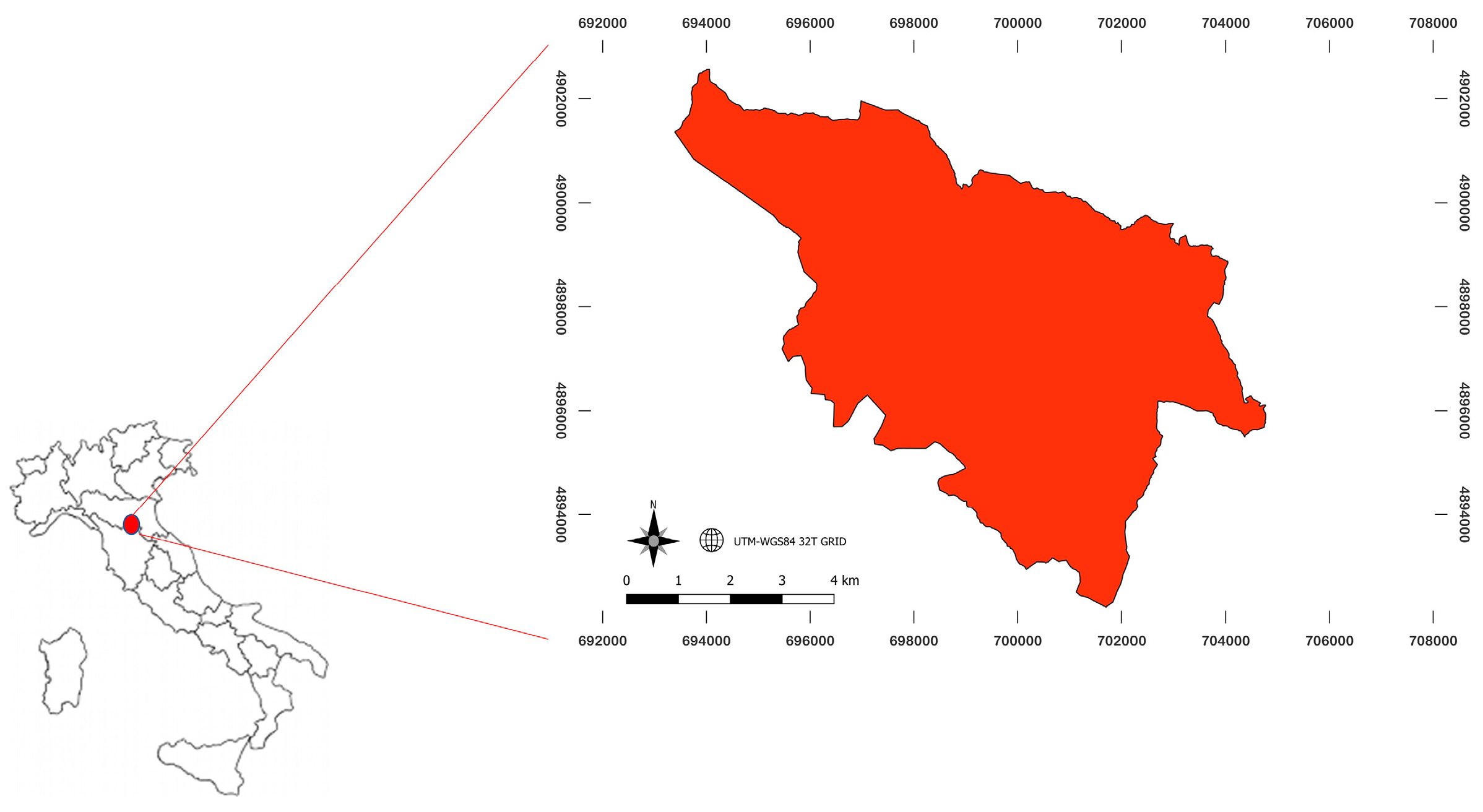
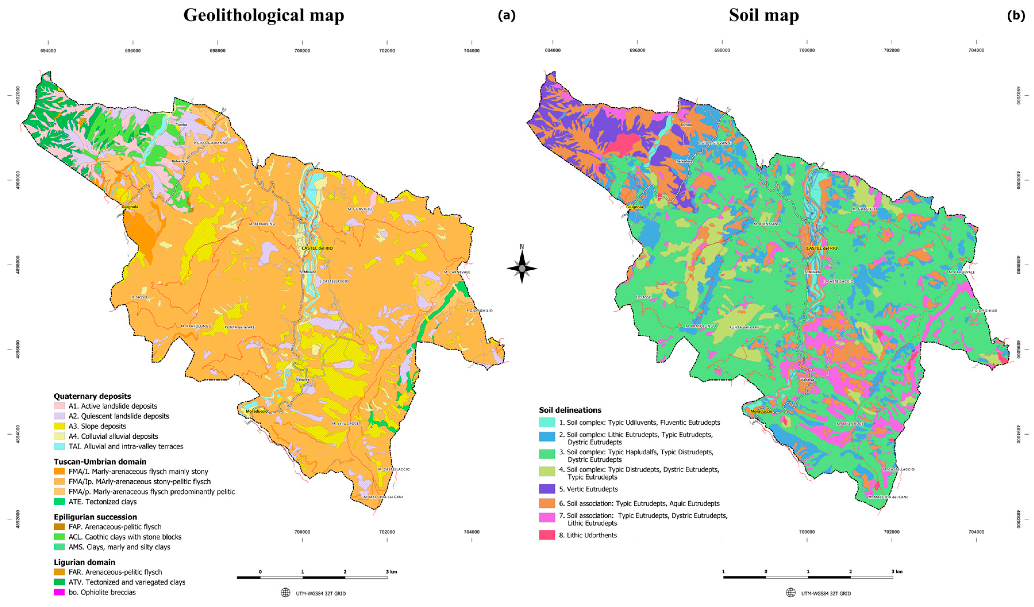
2.1. Study Area Framing
2.2. Indicators for the Assessment of Land Suitability for Chestnut Groves for Fruit Production
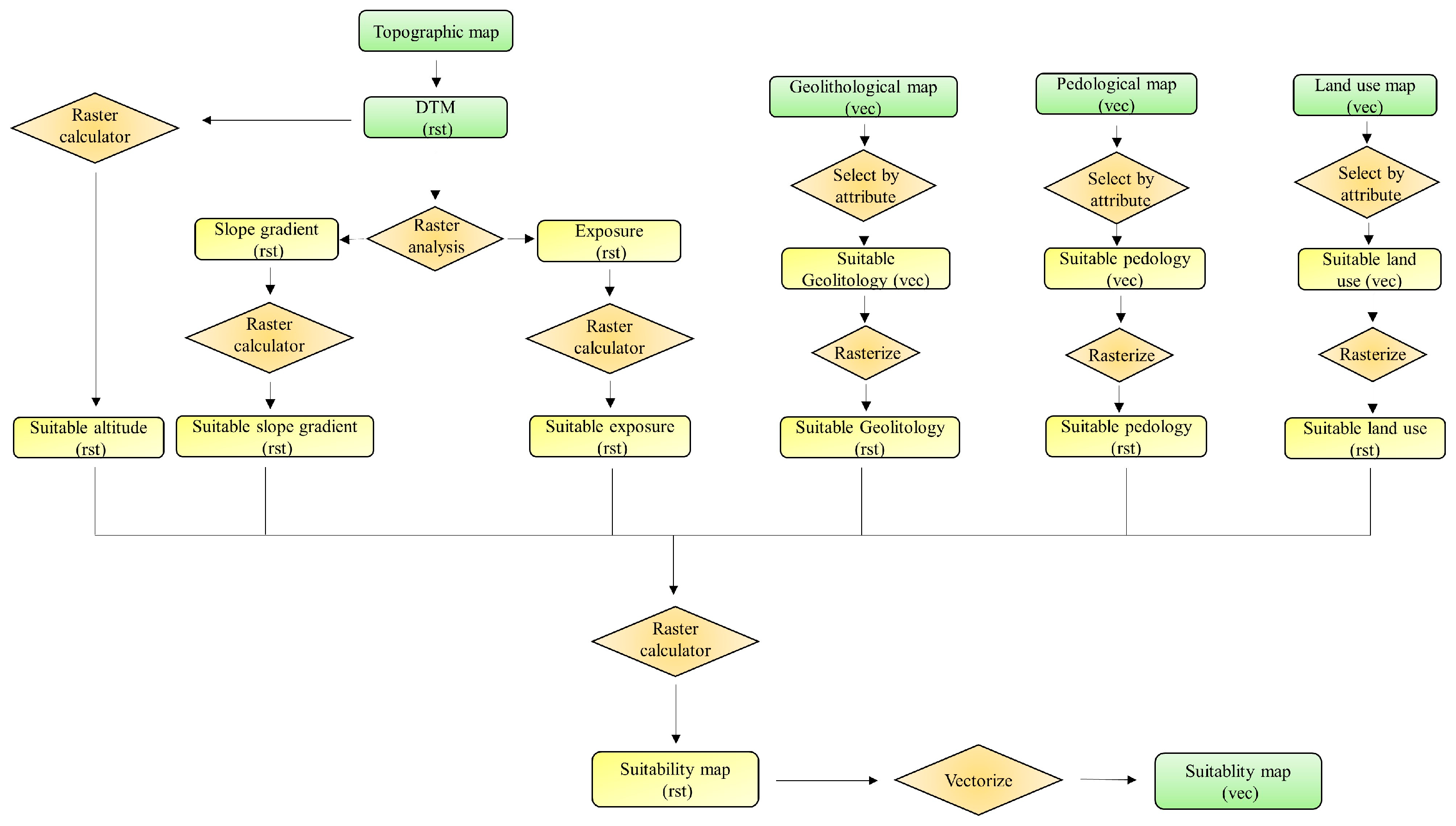
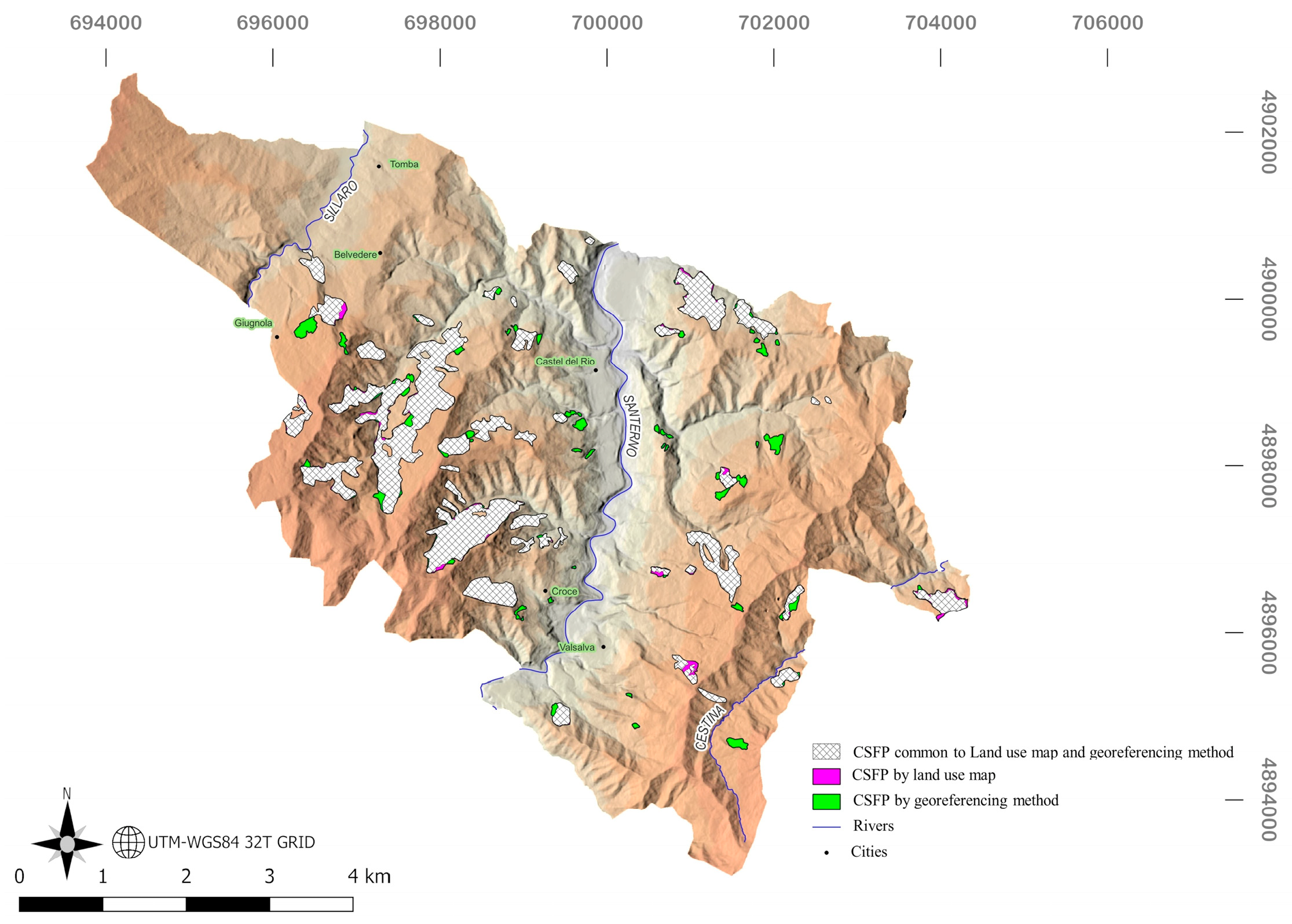
2.3. GIS-Based Approach for the Identification of Areas Currently under Chestnut Grove Cultivation for Fruit Production
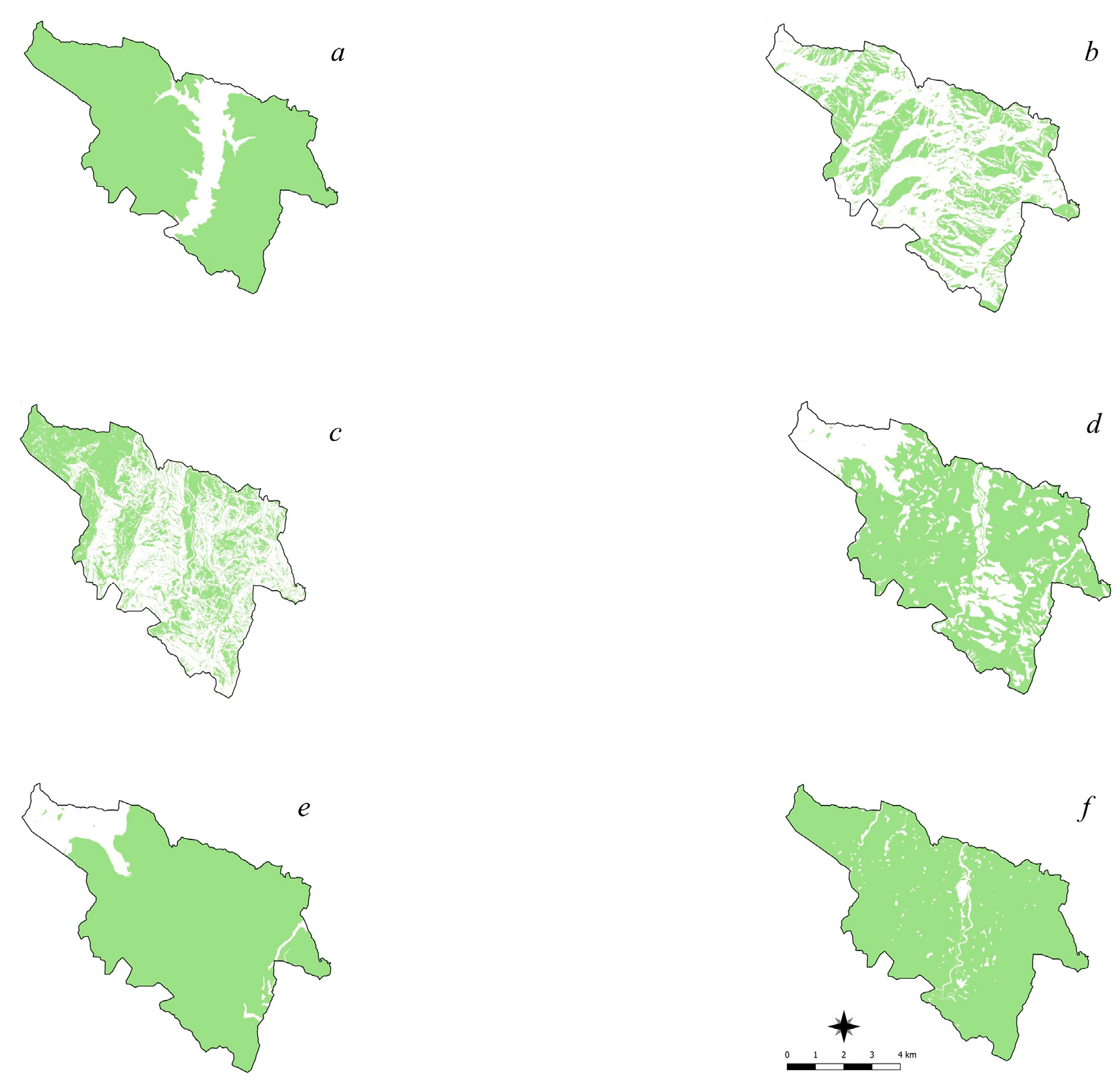
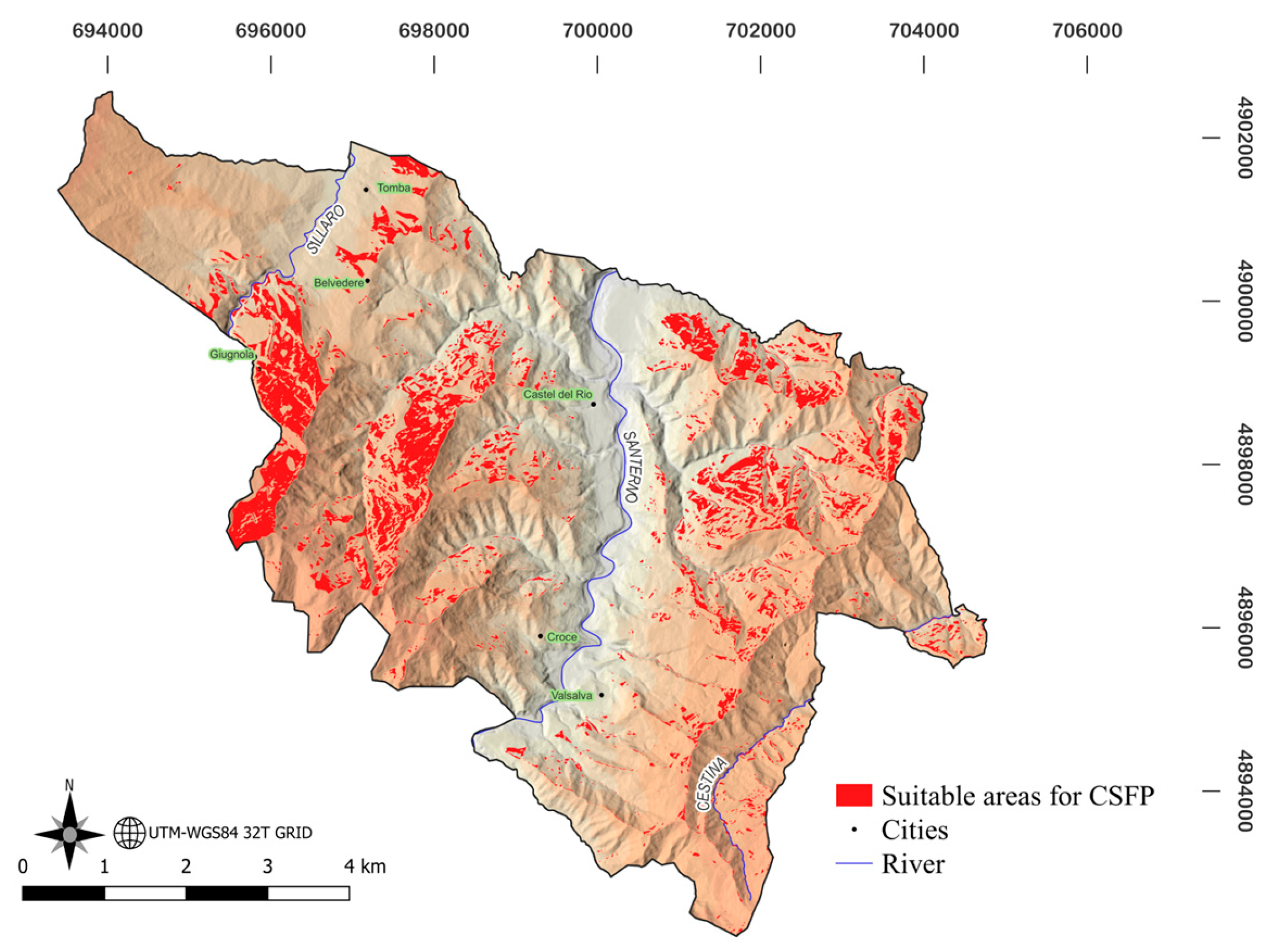
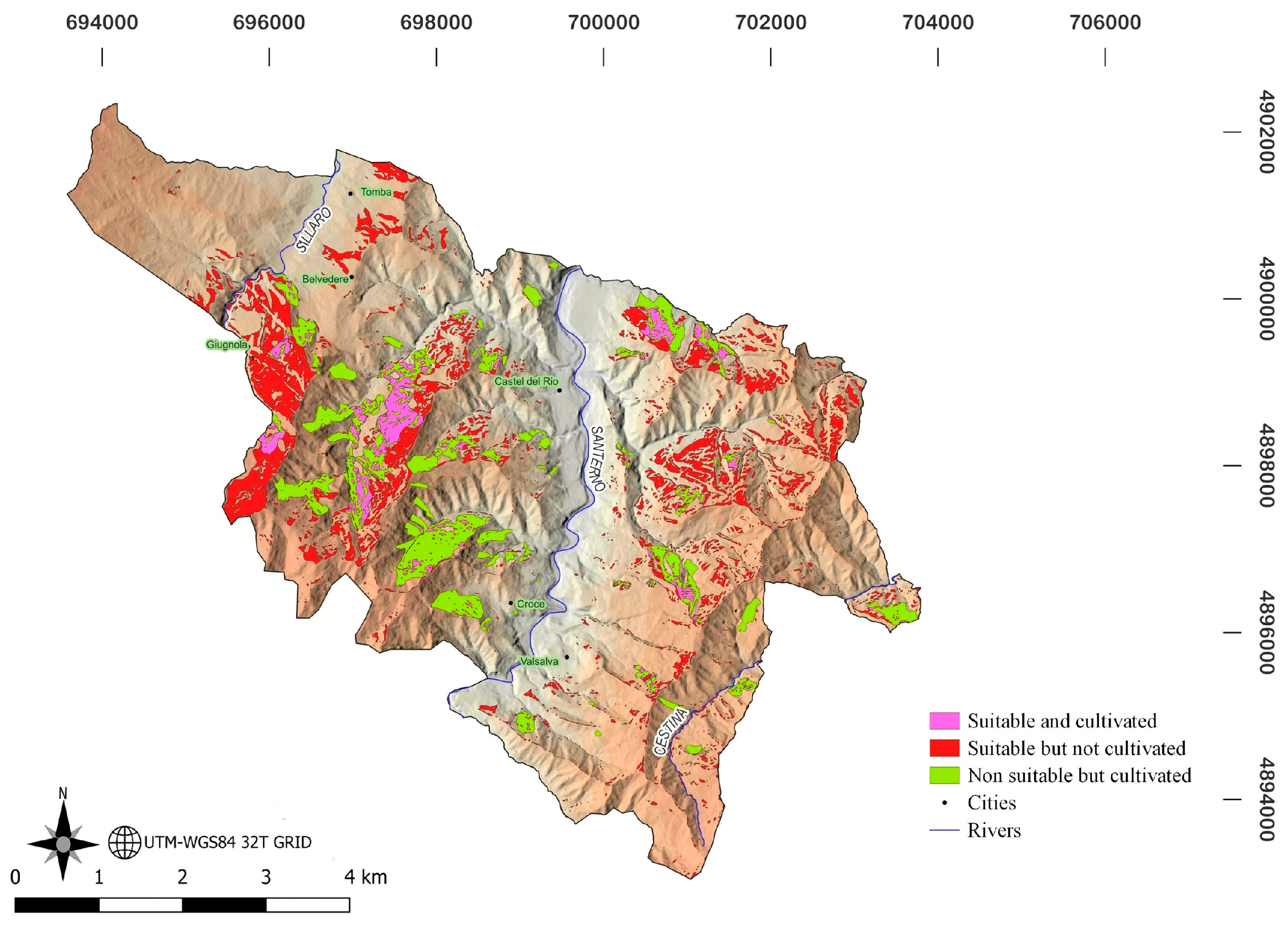
3. Results
4. Discussion
5. Conclusions
Author Contributions
Funding
Data Availability Statement
Conflicts of Interest
Appendix A

| Region | Geolithology | Municipality/Locality | Altitude m asl | Slope % | Sources |
|---|---|---|---|---|---|
| Piedmont | Mycascists, gneisses, gneiss glanders | Low Alpine slopes (Turin and Cuneo) | 400–900 | 30–60 | [94] |
| Detrital conoids referred to as gneisses | Low Alpine slopes (Turin and Cuneo) | 300–900 | 30–80 | [94] | |
| Siliceous matrix colluvium with gneiss predominance | Low mountain slopes (Verbano) | 200–700 | 30–60 | [94] | |
| Porphyries with mica-schists and quartzites included | Gentle mountain slopes (Vercellese, Novarese) | 400–700 | 15–40 | [94] | |
| Porphyries covered by ancient alluvial deposits | Transition between plain and pre-alpine reliefs | 200–400 | 10–20 | [94] | |
| Gneiss | Biella and Turin Pre-Alps | 400–700 | 15–40 | [94] | |
| Lombardy | Schistous and micaceous gneisses | Bacino torrente Bitto di Gerola (SO) | 820–850 | 50–60 | [95] |
| Slope debris gneisses and mica-schists | Val Grosina (SO) | 670–700 | 35–40 | [96] | |
| Marly limestones, dolomitic limestones, and dolomites | Bergamasque Hinterland | 270–670 | 35–40 | [97] | |
| Ferretised pebbles and sands in an advanced state of alteration | Pinewood of Appiano Gentile-Tradate | 320–375 | 5–40 | [98] | |
| Trentino | Hard limestones, porphyries, siliceous sandstones, and glacial siliceous deposits | Valle delle Chiese (Darzo, Lodrone, Daone) | 400–700 | 35–50 | [99] |
| Rhyolites, rhyodacites, phyllites, and mica-schists with widespread glacial overburden | Valsugana (RoncegnoT., Strigno, Castagnè, Caldonazzo) | 500–900 | 25–45 | [99] | |
| Limestones and marly limestones with possible glacial cover with mixed lithology | Brentonico Plateau (Castione) | 200–800 | 30–40 | [99] | |
| Hard limestones, marly limestones with glacial cover with mixed lithology | Upper Garda Trentino (Nago, Drena, Tenna) | 200–600 | 35–45 | [99] | |
| Rhyolites, rhyodacites, and dacites with glacial overburdens | Cembra Valley (Albiano) | 500–800 | 30–60 | [99] | |
| Friuli V.G. | Flysch with alternating arenites with calcareous-siliceous marls | Pre-Alpine reliefs Col Budoia | 100–150 | 20–30 | [100] |
| Conglomerate of predominantly calcareous nature with arenaceous and itic interlayers | Pre-Alpine reliefs Sequals Col Pallotta | 300–350 | 25–35 | [100] | |
| Veneto | White mica phyllites, corite, and albite | Venetian Pre-Alps | 450–650 | 10–30 | [101] |
| Calcareous conglomerates in karst morphologies | Montello and Berici Hills | 100–200 | 5–10 | [102] | |
| Acid volcanic rocks (rhyolites and trachytes) | Euganean Hills | 300–600 | 15–30 | [102] | |
| Emilia-Romagna | Sandstones and pelitic sandstones | Upper Frignano (MO) Upper Reno Valley | 900–1000 | 50–70 | [103] |
| Pelitic limestone flysch | High Apennines Reggiano-Parmense | 800–1000 | 40–60 | [104] | |
| Pelitic sandstones and marly limestones | Upper Santerno and Savena Valleys | 850–1000 | 30–50 | [105] | |
| Conglomeratic-pelitic sandstone deposits | Sillaro and Lavino Valleys | 450–600 | 10–38 | [106] | |
| Sandstones with arenaceous-pelitic intercalations | Upper Idice Valley | 250–500 | 30–45 | [107] | |
| Tuscany | Quartz-latitic volcanites and pyroclastic deposits | Monte Amiata (Arcidosso, Castel del Piano, Seggiano (GR)) | 950–1250 | 10–35 | [108] |
| Silty schists, marls, and sandstones | Londa (FI), Vernio (PO) | 500–700 | 35–60 | [108] | |
| Turbiditic flysch, marls, and marly clays | Camporgiano (LU) | 50-160 | 35-40 | [108] | |
| Quartzose-felspathic sandstones | Arezzo, Poppi (AR), Firenzuola (FI), Molazzano (LU) | 400-900 | 14-40 | [75] | |
| Pebbly sediments and polygenic conglomerates interbedded with clayey sands | Aulla, Nardi (MS) | 150–270 | 10–25 | [108] | |
| Calcareous polygenic conglomerates | Aulla (MS) | 100–400 | 15–30 | [108] | |
| Latium | Earthy tuffs with black and white pumice | Sabatini Mountains | 300–700 | 10–20 | [109] |
| Earthy tuffs | Montesanti | 980–1000 | 25–30 | [110] | |
| Abruzzo | Pelitic-arenaceous alternation with debris-colluvial belts at the base of slopes | Rocca S. Maria, Montorio del Vomano (TE) Montereale (AQ) | 800–1200 | 20–35 | [111] |
| Ancient terraces with fluvio lacustrine and clastic volcanic sediments | Oricola, Carsoli (AQ) | 500–800 | 0–13 | [111] | |
| Linear slopes on marly limestone substrates | Monreale, Monte Genzano, Pettorato sul Gizio (AQ) | 800–1200 | 20–35 | [111] | |
| Molise | Dolomitic limestone affected by pyroclastic cover | S. Massimo | 850–900 | 10–20 | [112] |
| Campania | Mesozoic carbonate rocks with pyroclastic overburden | Lattari and Picentini Mountains (Campania Region, 2004) | 300–1100 | 35–60 | [113] |
| Carbonate rocks with pyroclastic overburden | Upper Telesina Valley | 600–750 | 20–30 | [113] | |
| Mesozoic dolomite and limestone with pyroclastite cover | Caruso and Cuculo Mountains mountain system | 100–600 | 15–35 | [113] | |
| Sandstones, marly sandstones, and conglomerates | Pre-Apennine hills of basso Ufita and Conca Avellinese | 300–400 | 15–30 | [113] | |
| Conglomerates and sands | Pre-Apennine hills of Benevento | 300–400 | 25–40 | [113] | |
| Clay formations with pyroclastic coverings | Irpinia and Sannio hills | 250–450 | 20–30 | [113] | |
| Fluvio-lacustrine deposits | Upper Sele Valley | 300–500 | 15–25 | [113] | |
| Fluvio-lacustrine deposits | Lauro-Baianese Valley | 150–300 | 10–20 | [113] | |
| Basilicata | Vulture volcanic reliefs with pyroclastic coverings | Santa Maria | 700–800 | 10–15 | [114] |
| Calabria | Phylladic schists and granites | Coastal chain and Presila of Cosenza | 300–900 | 10–30 | [44] |
| Alteration sand of granites | Sila Greca, Upper Ionian Cosenza | 500–1000 | 20–30 | [44] | |
| Alteration granites | Presila of Crotone and Catanzaro | 800–100 | 15–25 | [44] | |
| Phyllites, leucoscists, biotic schists | Serre of Catanzaro and M.te Reventino | 600–900 | 10–25 | [44] | |
| Alteration sand of granites | Serre Vibonesi | 600–900 | 10–20 | [44] | |
| Heavily altered granite rocks and tertiary conglomerates | Western and Eastern Aspromonte | 300–1200 | 15–40 | [44] | |
| Sardinia | Palaeozoic granites and schists | Mandrolisai. Municipalities of Desulo, Tonara, Balvi, Aritzo | 600–700 | 20–30 | [115] |
| Metavolcanites and ignimbrites | Goceano, Monte Pisani | 700–900 | 20–25 | [115] | |
| Sicily | Heavily weathered sandstones | Erei Mountains, Rossomanno (EN) | 550–890 | 15–25 | [116] |
| Inert quartz-arenites to micaceous pelite | Forest of Ficuzza. Rocca Busambra (PA) | 600–1000 | 10–15 | [117] | |
| Altered calcarenites and limestones | Mount Peloritani, Musolino, Novara (ME) | 380–1050 | 10–15 | [116] | |
| Basic volcanic rocks | Mount Etna, Randazzo, Pirao (CT) | 600–1210 | 10–20 | [116] |
References
- Conedera, M.; Tinner, W.; Krebs, P.; de Rigo, D.; Caudullo, G. Castanea sativa in Europe: Distribution, habitat, usage and threats. In European Atlas of Forest Tree Species; San-Miguel-Ayanz, J., de Rigo, D., Caudullo, G., Houston Durrant, T., Mauri, A., Eds.; European Commision: Luxembourg, 2016; p. e0125e0. Available online: https://w3id.org/mtv/FISE-Comm/v01/e0125e0 (accessed on 20 November 2022).
- Conedera, M.; Krebs, P. History, present situation and perspective of chestnut cultivation in Europe. Acta Hort. 2007, 784, 23–28. [Google Scholar] [CrossRef]
- Conedera, M.; Manetti, M.C.; Giudici, F.; Amorini, E. Distribution and economic potential of the Sweet chestnut (Castanea sativa Mill.) in Europe. Ecol. Mediterr. 2004, 30, 179–193. [Google Scholar] [CrossRef]
- Tamantini, S.; Bergamasco, S.; Portoghesi, L.; Vettraino, A.M.; Zikeli, F.; Mugnozza, G.S.; Romagnoli, M. Detection, description, and technological properties of colour aberration in wood of standards and shoots from a chestnut (Castanea sativa Mill.) coppice stand. Eur. J. For. Res. 2022, 141, 683–698. [Google Scholar] [CrossRef]
- ISTAT. Coltivazioni: Coltivazioni Legnose Fruttifere. Available online: www.istat.it (accessed on 22 November 2022).
- Conedera, M.; Krebs, P.; Tinner, W.; Pradella, M.; Torriani, D. The cultivation of Castanea sativa (Mill.) in Europe, from its origin to its diffusion on a continental scale. Veg. Hist. Archaeobot 2004, 13, 161–179. [Google Scholar] [CrossRef] [Green Version]
- Zlatanov, T.; Schleppi, P.; Velichkov, I.; Hinkov, G.; Georgieva, M.; Eggertsson, O.; Zlatanova, M.; Vacik, H. Structural diversity of abandoned chestnut (Castanea sativa Mill.) dominated forests: Implications for forest management. For. Ecol. Manag. 2013, 291, 326–335. [Google Scholar] [CrossRef]
- Pezzi, G.; Maresi, G.; Conedera, M.; Ferrari, C. Woody species composition of chestnut stands in the Northern Apennines: The result of 200 years of changes in land use. Landsc. Ecol. 2011, 26, 1463–1476. [Google Scholar] [CrossRef]
- Conedera, M.; Krebs, P.; Gehring, E.; Wunder, J.; Hülsmann, L.; Abegg, M.; Maringer, J. How future-proof is Sweet chestnut (Castanea sativa) in a global change context? For. Ecol. Manag. 2021, 494, 119320. [Google Scholar] [CrossRef]
- FAOSTAT. Statistics Division of Food and Agriculture Organization of the United Nations, Roma. 2022. Available online: https://www.fao.org/faostat/en/#home (accessed on 25 November 2022).
- Massantini, R.; Moscetti, R.; Frangipane, M.T. Evaluating progress of chestnut quality: A review of recent developments. Trends Food Sci. Technol. 2021, 113, 245–254. [Google Scholar] [CrossRef]
- Nocetti, M.; Brunetti, M.; Bacher, M. Efficiency of the machine grading of chestnut structural timber: Prediction of strength classes by dry and wet measurements. Mater. Struct. 2016, 49, 4439–4450. [Google Scholar] [CrossRef]
- Siqueira, D.S.; Marques, J.; Pereira, G.T. The use of landforms to predict the variability of soil and orange attributes. Geoderma 2010, 156, 410. [Google Scholar] [CrossRef]
- Vasu, D.; Srivastava, R.; Patil, N.G.; Tiwary, P.; Chandran, P.; Singh, S.K. A comparative assessment of land suitability evaluation methods for agricultural land use planning at village level. Land Use Policy 2018, 79, 146–163. [Google Scholar] [CrossRef]
- Ray, P.; Chattaraj, S.; Bandyopadhyay, S.; Jena, R.K.; Singh, S.K.; Ray, S.K. Shifting cultivation, soil degradation, and agricultural land-use planning in the northeastern hill region of India using geo-spatial techniques. Land Degrad. Dev. 2021, 32, 3870–3892. [Google Scholar] [CrossRef]
- AbdelRahman, M.A.E.; Natarajan, A.; Hegde, R. Assessment of land suitability and capability by integrating remote sensing and GIS for agriculture in Chamarajanagar district, Karnataka, India. Egypt. J. Remote Sens. Space Sci. 2016, 19, 125–141. [Google Scholar] [CrossRef] [Green Version]
- Özşahin, E.; Ozdes, M. Agricultural land suitability assessment for agricultural productivity based on GIS modeling and multi-criteria decision analysis: The case of Tekirdağ province. Environ. Monit. Assess. 2022, 194, 41. [Google Scholar] [CrossRef] [PubMed]
- Alewell, C.; Meusburger, K.; Brodbeck, M.; Banninger, D. Methods to describe and predict soil erosion in mountain regions. Landsc. Urban Plan. 2008, 88, 46–53. [Google Scholar] [CrossRef]
- FAO. Understanding Mountain Soils: A Contribution from Mountain Areas to the International Year of Soils; Romeo, R., Vita, A., Manuelli, S., Zanini, E., Freppaz, M., Stanchi, S., Eds.; FAO: Rome, Italy, 2015. [Google Scholar]
- Bruzzese, S.; Blanc, S.; Brun, F. Strategies for the valorisation of chestnut resources in Italian mountainous areas from a sustainable development perspective. Resources 2020, 9, 60. [Google Scholar] [CrossRef]
- Arnous, M.O.; Hassan, M.A.A. Image processing and land information system for soil assessment of El-Maghara Area, North Sinai, Egypt. In Proceedings of the International Conference on Water Resources and Arid Environment, Riyadh, Saudi Arabia, 26–29 November 2006. [Google Scholar]
- De Feudis, M.; Gherardi, M.; Falsone, G.; Speranza, M.; Vianello, G.; Vittori Antisari, L. GIS-based soil maps as tools to evaluate land capability and suitability in a coastal reclaimed area (Ravenna, northern Italy). Int. Soil Water Conserv. Res. 2021, 9, 167–179. [Google Scholar] [CrossRef]
- Kurowska, K.; Marks-Bielska, R.; Bielski, S.; Aleknavicius, A.; Kowalczyk, C. Geographic information systems and the sustainable development of rural areas. Land 2020, 10, 6. [Google Scholar] [CrossRef]
- Mikoláš, M.; Ujházy, K.; Jasík, M.; Wiezik, M.; Gallay, I.; Polák, P.; Vysoký, J.; Čiliak, M.; Meigs, G.V.; Svoboda, M.; et al. Primary forest distribution and representation in a Central European landscape: Results of a large-scale field-based census. For. Ecol. Manag. 2019, 449, 117466. [Google Scholar] [CrossRef]
- Atay Kaya, İ.; Kut Görgün, E. Land use and land cover change monitoring in Bandırma (Turkey) using remote sensing and geographic information systems. Environ. Monit. Assess. 2020, 192, 430. [Google Scholar] [CrossRef]
- Cienciała, A.; Sobolewska-Mikulska, K.; Sobura, S. Credibility of the cadastral data on land use and the methodology for their verification and update. Land Use Policy 2021, 102, 105–204. [Google Scholar] [CrossRef]
- Lauteri, M.; Monteverdi, M.; Scarascia-Mugnozza, G. Preservation of chestnut (Castanea sativa Mill.) genetic resources and adaptive potentialin relation to environmental changes. Acta Hortic. 2009, 866, 677–682. [Google Scholar] [CrossRef]
- FAO. A Framework for Land Evaluation; UN Food and Agriculture Organization (FAO): Rome, Italy, 1981; Second printing; ISBN 92-5-100111-1. [Google Scholar]
- Sonneveld, M.P.W.; Hack-ten Broeke, M.J.D.; Van Diepen, C.A.; Boogaard, H.L. Thirty years of systematic land evaluation in the Netherlands. Geoderma 2010, 156, 84–92. [Google Scholar] [CrossRef]
- Triantafilis, J.; Ward, W.T.; McBratney, A.B. Land suitability assessment in the Namoi Valley of Australia, using a continuous model. Aust. J. Soil Res. 2001, 39, 273–290. [Google Scholar] [CrossRef]
- Joss, B.N.; Hall, R.J.; Sidders, D.M.; Keddy, T.J. Fuzzy-logic modelling of land suitability for hybrid poplar across the Prairie Provinces of Canada. Environ. Monit. Assess 2008, 141, 79–96. [Google Scholar] [CrossRef]
- Elsheikh, R.; Rashid, B.A.; Shariff, M.; Amiri, F.; Ahmad, N.B.; Balasundram, S.K.; MohdSoome, M.A. Agriculture Land Suitability Evaluator (ALSE): A decision and planning support tool for tropical and subtropical crops. Comput. Electron. Agric. 2013, 93, 98–110. [Google Scholar] [CrossRef] [Green Version]
- Aymen, A.T.; Al-husban, Y.; Farhan, I. Land suitability evaluation for agricultural use using GIS and remote sensing techniques: The case study of Ma’an Governorate, Jordan. Egypt. J. Remote Sens. Space Sci. 2021, 24, 109–117. [Google Scholar] [CrossRef]
- Yalew, S.G.; Van Griensven, A.; Mul, M.L.; van der Zaag, P. Land suitability analysis for agriculture in the Abbay basin using remote sensing, GIS and AHP techniques. Model. Earth Syst. Environ. 2016, 2, 101. [Google Scholar] [CrossRef] [Green Version]
- Saleh, A.M.; Belal, A.B.; Mohamed, E.S. Land resources assessment of El-Galaba basin, South Egypt for the potentiality of agriculture expansion using remote sensing and GIS techniques. Egypt. J. Remote Sens. Space Sci. 2015, 18, S19–S30. [Google Scholar] [CrossRef] [Green Version]
- Habibie, M.I.; Noguchi, R.; Shusuke, M.; Ahamed, T. Land suitability analysis for maize production in Indonesia using satellite remote sensing and GIS-based multicriteria decision support system. GeoJournal 2021, 86, 777–807. [Google Scholar] [CrossRef]
- Tercan, E.; Dereli, M.A. Development of a land suitability model for citrus cultivation using GIS and multi-criteria assessment techniques in Antalya province of Turkey. Ecol. Indic. 2020, 117, 106549. [Google Scholar] [CrossRef]
- Antolini, G.; Auteri, L.; Pavan, V.; Tomei, F.; Tomozeiu, R.; Marletto, V. A daily high-resolution gridded climatic data set for Emilia-Romagna, Italy, during 1961–2010. Int. J. Climatol. 2015, 36, 1970–1986. [Google Scholar] [CrossRef] [Green Version]
- Regione Emilia-Romagna. DTM 5×5—Geoportale Regione. 2009. Available online: https://geoportale.regione.emilia-romagna.it/catalogo/dati-cartografici/altimetria/layer-2 (accessed on 27 October 2022).
- Regione Emilia-Romagna. Carta Geologica 1:10000—Banca Dati Geologica, 1:10.000—Unità Geologiche—10k. 2006. Available online: https://geoportale.regione.emilia-romagna.it/catalogo/dati-cartografici/informazioni-geoscientifiche/geologia/banca-dati-geologica-1-10.000/layer-11 (accessed on 27 October 2022).
- Soil Survey Staff. Keys to Soil Taxonomy, 12th ed.; USDA–Natural Resources Conservation Service: Washington, DC, USA, 2014. [Google Scholar]
- De Philippis, A. Forest ecology and phytoclimatology. Unasylva 1951, 5, 1. [Google Scholar]
- Del Favero, R. (Ed.) I Tipi Forestali della Lombardia. Regione Lombardia; CIERRE: Sommacampagna, Italy, 2002. [Google Scholar]
- Arcidiaco, L.; Ciancio, O.; Garfì, V.; Iovino, F.; Menguzzato, G.; Nicolaci, A. Area di vegetazione e campo di idoneità ecologica del castagno in Calabria. L’Italia For. E Mont. 2006, 6, 489–506. Available online: https://hdl.handle.net/11695/319 (accessed on 2 November 2022). [CrossRef] [Green Version]
- Lolli, G.; Musolesi, M. Il Castagneto da Frutto: Manuale Pratico di Innesto, Potatura e Conduzione: Tecniche Di Recupero Dei Castagneti Abbandonati, Conversione Dei Cedui in Castagneti da Frutto: Indagini Svolte Nell’appennino Bolognese; Bononia University Press: Bologna, Italy, 2006; pp. 1–150. [Google Scholar]
- Bounous, G. Il Castagno; Edagricole: Milano, Italy, 2004; pp. 1–432. [Google Scholar]
- Comel, A. Basi Pedologiche per la Valutazione Dei Terreni; Edagricole: Milano, Italy, 1975; pp. 1–138. [Google Scholar]
- Diaz, J.V.R.; Varela, E.R.D.; Anta, M.B.; Álvarez, P.Á. Sweet chestnut agroforestry systems in North-western Spain: Classification, spatial distribution and an ecosystem services assessment. For. Syst. 2018, 27, 10. [Google Scholar]
- Mariotti, B.; Castellotti, T.; Conedera, M.; Corona, P.; Manetti, M.C.; Romano, R.; Tani, A.; Maltoni, A. Linee Guida per la Gestione Selvicolturale dei Castagneti da Frutto; CREA: Rome, Italy, 2019; ISBN 978-88-3385-017-7. [Google Scholar]
- Rodrigues, A.; Gonçalves, A.B.; Costa, R.L.; Gomes, A.A. GIS-based assessment of the chestnut expansion potential: A case-study on the Marvão productive area, Portugal. Agriculture 2021, 11, 1260. [Google Scholar] [CrossRef]
- Nicoletti, R.; Beccaro, G.L.; Sekara, A.; Cirillo, C.; Di Vaio, C. Endophytic Fungi and Ecological Fitness of Chestnuts. Plants 2021, 10, 542. [Google Scholar] [CrossRef]
- Schoeneberger, P.J.; Wysocki, D.A.; Benham, E.C. Field Book for Describing and Sampling Soils; Version 3.0; Natural Resources Conservation Service: Washington, DC, USA; National Soil Survey Center: Lincoln, NE, USA, 2012. [Google Scholar]
- Gee, G.W.; Bauder, J.W.; Klute, A. Methods of Soil Analysis, Part 1, Physical and Mineralogical Methods; Soil Science Society of America: Madison, WI, USA; American Society of Agronomy: Madison, WI, USA, 1986. [Google Scholar]
- Loeppert, R.H.; Suarez, D.L. Carbonate and Gypsun; USDA-ARS/UNL Faculty: Lincoln, CA, USA, 1996. [Google Scholar]
- Orsini, L.; Remy, J.C. The simultaneous determination of cation-exchange capacity and total exchangeable bases (BE) using cobaltihexammine chloride. Bull. Assoc. Fr. Pour L’etude Sol. Sci. Sol. 1976, 4, 269–275. [Google Scholar]
- Ciesielski, H.; Sterckeman, T. Determination of cation exchange capacity and exchangeable cations in soils by means of cobalt hexamine trichloride. Effects of experimental conditions. Agronomie 1997, 17, 1–7. [Google Scholar] [CrossRef] [Green Version]
- Chen, Z.; Huang, M.; Xiao, C.; Qi, S.; Du, W.; Zhu, D.; Altan, O. Integrating remote sensing and spatiotemporal analysis to characterize artificial vegetation restoration suitability in desert areas: A Case Study of Mu Us Sandy Land. Remote Sens. 2022, 14, 4736. [Google Scholar] [CrossRef]
- Zheng, C.; Wen, Z.; Liu, Y.; Guo, Q.; Jiang, Y.; Ren, H.; Yang, Y. Integrating habitat suitability and the near-nature restoration priorities into revegetation plans based on potential vegetation distribution. Forests 2021, 12, 218. [Google Scholar] [CrossRef]
- Regione Emilia-Romagna. Uso del suolo di dettaglio dell’anno 2017—Coperture vettoriali uso del suolo di dettaglio—Edizione 2020—Geoportale Regione. 2020. Available online: https://geoportale.regione.emilia-romagna.it/download/dati-e-prodotti-cartografici-preconfezionati/pianificazione-e-catasto/uso-del-suolo/2017-coperture-vettoriali-uso-del-suolo-di-dettaglio-edizione-2020 (accessed on 27 October 2022).
- Pérez-Girón, J.C.; Alvarez-Alvarez, P.; Díaz-Varela, E.R.; Lopes, D.M.M. Influence of climate variations on primary production indicators and on the resilience of forest ecosystems in a future scenario of climate change: Application to sweet chestnut agroforestry systems in the Iberian Peninsula. Ecol. Indic. 2020, 113, 106199. [Google Scholar] [CrossRef]
- Freitas, T.R.; Santos, J.A.; Silva, A.P.; Fraga, H. Influence of climate change on chestnut trees: A review. Plants 2021, 10, 1463. [Google Scholar] [CrossRef]
- Scott, A.I. Factors influencing soil moisture and plant community distribution on Niwot Ridge, Front Range, Colorado, USA. Arct. Alp. Res. 1986, 18, 83–96. [Google Scholar] [CrossRef]
- Sidari, M.; Ronzello, G.; Vecchio, G. Muscolo, Influence of slope aspects on soil chemical and biochemical properties in a Pinus laricio forest ecosystem of Aspromonte (Southern Italy). Eur. J. Soil Biol. 2008, 44, 364–372. [Google Scholar] [CrossRef]
- McVicar, T.R.; Van Niel, T.G.; Li, L.; Hutchinson, M.F.; Mu, X.; Liu, Z. Spatially distributing monthly reference evapotranspiration and pan evaporation considering topographic influences. J. Hydrol. 2007, 338, 196–220. [Google Scholar] [CrossRef]
- Garcia-Ruiz, J.M.; Beguería, S.; Nadal-Romero, E.; Gonzalez-Hidalgo, J.C.; Lana-Renault, N.; Sanjuán, Y. A meta-analysis of soil erosion rates across the world. Geomorphology 2015, 239, 160–173. [Google Scholar] [CrossRef] [Green Version]
- Carter, B.J.; Ciolkosz, E.J. Slope gradient and aspect effects on soils developed from sandstone in Pennsylvania. Geoderma 1991, 49, 199–213. [Google Scholar] [CrossRef]
- Fazlollahi Mohammadi, M.; Jalali, S.G.H.; Kooch, Y.; Said-Pullicino, D. Slope gradient and shape effects on soil profiles in the northern mountainous forests of Iran. Eurasian Soil Sci. 2016, 49, 1366–1374. [Google Scholar] [CrossRef] [Green Version]
- Di Iorio, A.; Lasserre, B.; Scippa, G.S.; Chiatante, D. Root system architecture of Quercus pubescens trees growing on different sloping conditions. Ann. Bot. 2005, 95, 351–361. [Google Scholar] [CrossRef] [Green Version]
- Akıncı, H.; Özalp, A.Y.; Turgut, B. Agricultural land use suitability analysis using GIS and AHP technique. Comput. Electron. Agric. 2013, 97, 71–82. [Google Scholar] [CrossRef]
- Tang, X.; Liu, S.; Liu, J.; Zhou, G. Effects of vegetation restoration and slope positions on soil aggregation and soil carbon accumulation on heavily eroded tropical land of Southern China. J. Soils Sediments 2010, 10, 505–513. [Google Scholar] [CrossRef]
- Ezzati, S.; Tavankar, F.; Ghaffariyan, M.R.; Venanzi, R.; Latterini, F.; Picchio, R. The impact of weather and slope conditions on the productivity, cost, and GHG emissions of a ground-based harvesting operation in mountain hardwoods. Forests 2021, 12, 1612. [Google Scholar] [CrossRef]
- Cavalli, R.; Amishev, D. Steep terrain forest operations–challenges, technology development, current implementation, and future opportunities. Int. J. For. Eng. 2019, 30, 175–181. [Google Scholar] [CrossRef]
- Liu, Q.; Liu, Y.; Peng, J.; Zhang, T.; Li, Y. Linking GRNN and neighborhood selection algorithm to assess land suitability in low-slope hilly areas. Ecol. Indic. 2018, 93, 581–590. [Google Scholar] [CrossRef]
- Sheng, T.C. Soil Conservation for Small Farmers in the Humid Tropics; Food & Agriculture Organization of the United Nations: Rome, Italy, 1989. [Google Scholar]
- Sanesi, G. I suoli del Bacino dei torrenti Diaterna e lineamenti pedologici del Mugello e dell’Alta Valle del Santerno (Firenze); Progetto Finalizzato Conservazione del suolo; Centro di studio per la genesi, classificazione e cartografia del suolo: Florence, Italy, 1977; Volume 12, p. 99. [Google Scholar]
- Antoniazzi, A. La carta dei suoli della media valle del Santerno. Centro di studio per la genesi, classificazione e cartografia del suolo: Florence, Italy, 1977; Volume 39. [Google Scholar]
- Ahmad, N.S.B.N.; Mustafa, F.B.; Didams, G. A systematic review of soil erosion control practices on the agricultural land in Asia. Int. Soil Water Conserv. Res. 2020, 8, 103–115. [Google Scholar] [CrossRef]
- Tarolli, P.; Straffelini, E. Agriculture in hilly and mountainous landscapes: Threats, monitoring and sustainable management. Geogr. Sustain. 2020, 1, 70–76. [Google Scholar] [CrossRef]
- Moreno-de-las-Heras, M.; Lindenberger, F.; Latron, J.; Lana-Renault, N.; Llorens, P.; Arnáez, J.; Gallart, F. Hydro-geomorphological consequences of the abandonment of agricultural terraces in the Mediterranean region: Key controlling factors and landscape stability patterns. Geomorphology 2019, 333, 73–91. [Google Scholar] [CrossRef]
- Dossche, R.; Rogge, E.; Van Eetvelde, V. Detecting people’s and landscape’s identity in a changing mountain landscape. An example from the northern Apennines. Landsc. Res. 2016, 41, 934–949. [Google Scholar] [CrossRef]
- Cevasco, R.; Moreno, D.; Balzaretti, R.; Watkins, C. Historical chestnut cultures, climate and rural landscapes in the Apennines. In The Future of Heritage as Climates Change: Loss, Adaptation and Creativity; Harvey, D., Perry, J., Eds.; Routledge: London, UK, 2015; pp. 130–147. [Google Scholar]
- Tarolli, P.; Preti, F.; Romano, N. Terraced landscapes: From an old best practice to a potential hazard for soil degradation due to land abandonment. Anthropocene 2014, 6, 10–25. [Google Scholar] [CrossRef]
- Antle, J.M.; Stoorvogel, J.J.; Valdivia, R.O. Assessing the economic impacts of agricultural carbon sequestration: Terraces and agroforestry in the Peruvian Andes. Agric. Ecosyst. Environ. 2007, 122, 435–445. [Google Scholar] [CrossRef]
- Arnaez, J.; Lasanta, T.; Errea, M.P.; Ortigosa, L. Land abandonment, landscape evolution and soil erosion in a Spanish Mediterranean mountain region: The case of Camero. Land Degrad 2011, 22, 537–550. [Google Scholar] [CrossRef]
- Emerton, L.; Snyder, K.A. Rethinking sustainable land management planning: Understanding the social and economic drivers of farmer decision-making in Africa. Land Use Policy 2008, 79, 684–694. [Google Scholar] [CrossRef]
- Gassman, P.W.; Osei, E.; Saleh, A.; Rodecap, J.; Norvell, S.; Williams, J. Alternative practices for sediment and nutrient loss control on livestock farms in northeast Iowa. Agric. Ecosyst. Environ. 2006, 117, 135–144. [Google Scholar] [CrossRef]
- De Feudis, M.; Falsone, G.; Vianello, G.; Vittori Antisari, L. The conversion of abandoned chestnut forests to managed ones does not affect the soil chemical properties and improves the soil microbial biomass activity. Forests 2020, 11, 786. [Google Scholar] [CrossRef]
- Corona, P.; Frangipane, M.T.; Moscetti, R.; Lo Feudo, G.; Castellotti, T.; Massantini, R. Chestnut cultivar identification through the data fusion of sensory quality and FT-NIR spectral data. Foods 2021, 10, 2575. [Google Scholar] [CrossRef]
- Vasconcelos, M.C.B.M.; Bennett, R.N.; Quideau, S.; Jacquet, R.; Rosa, E.A.; Ferreira-Cardoso, J.V. Evaluating the potential of chestnut (Castanea sativa Mill.) fruit pericarp and integument as a source of tocopherols, pigments and polyphenols. Ind. Crops Prod. 2010, 31, 301–311. [Google Scholar] [CrossRef]
- De la Rosa, D.; Mayol, F.; Díaz-Pereira, E.; Fernandez, M.; De la Rosa, D., Jr. A land evaluation decision support system (MicroLEIS DSS) for agricultural soil protection: With special reference to the Mediterranean region. Environ. Model. Softw. 2004, 19, 929–942. [Google Scholar] [CrossRef]
- Tempa, K.; Aryal, K.R. Semi-automatic classification for rapid delineation of the geohazard-prone areas using Sentinel-2 satellite imagery. SN Appl. Sci. 2022, 4, 141. [Google Scholar] [CrossRef]
- Wassie, Y.A.; Koeva, M.N.; Bennett, R.M.; Lemmen, C.H.J. A procedure for semi-automated cadastral boundary feature extraction from high-resolution satellite imagery. J. Spat. Sci. 2018, 63, 75–92. [Google Scholar] [CrossRef] [Green Version]
- Ntihinyurwa, P.D.; De Vries, W.T. Farmland fragmentation, farmland consolidation and food security: Relationships, research lapses and future perspectives. Land 2021, 10, 129. [Google Scholar] [CrossRef]
- IPLA—Regione Piemonte. Carta dei Suoli del Piemonte 1:250.000; Note Illustrative; SELCA: Firenze, Italy, 2007. [Google Scholar]
- ERSAL Regione Lombardia. Progetto Ricerca Integrata Sulla Degradazione dei Versanti in Territori Montani. I Suoli del Bacino del Torrente Bitto di Gerola; Arti Grafiche Vertemati: Vimercate, Italy, 1994. [Google Scholar]
- Assi, I.; Comolli, R.; Previtali, F. Prime osservazioni sui suoli della Val Grosina. Natura Bresciana. Nat. Brescia Ann. Mus. Civ. Sc. 1993, 29, 97–122. [Google Scholar]
- ERSAL Regione Lombardia. Progetto Carta Pedologica. In I Suoli Dell’Hinterland Bergamasco; Arti Grafiche Chiribella: Bozzolo, Italy, 1992. [Google Scholar]
- ERSAL Regione Lombardia. Progetto Carta Pedologica. In I suoli del Parco Pineta di Appiano Gentile—Tradate e Aree Limitrofe; Grafiche Boniardi: Milano, Italy, 1988. [Google Scholar]
- Sartori, G.; Mancabelli, A. Carta dei Suoli del Trentino Scala 1:250.000; Museo Tridentino di Scienze Naturali: Trento, Italy; Consiglio per la Ricerca e la Sperimentazione in Agricoltura: Roma, Italy, 2009. [Google Scholar]
- ERSA Agenzia Regionale per lo Sviluppo Rurale. Suoli e Paesaggi del Friuli Venezia Giulia; Pianura: Gorizia, Italy, 2006; Volume 1. [Google Scholar]
- Marcolin, E.; Manetti, M.C.; Pelleri, F.; Conedera, M.; Pezzatti, G.B.; Lingua, E.; Pividori, M. Seed regeneration of sweet chestnut (Castanea sativa Miller) under different coppicing approaches. For. Ecol. Manag. 2020, 472, 11827. [Google Scholar] [CrossRef]
- ARPAV Regione Veneto. Carta Dei Suoli del Veneto; Note Illustrative; APRAV: Padova, Italy, 2005; ISBN 88-7504-097-4. [Google Scholar]
- De Feudis, M.; Falsone, G.; Vianello, G.; Vittori Antisari, L. Stable organic carbon pool rises in soil under chestnut (Castanea sativa Mill.) forest for timber production after 15 years since grafting onto satin-cut stumps. EQA 2020, 40, 1–10. [Google Scholar] [CrossRef]
- Vittori Antisari, L.; Vianello, G.; Pontalti, F.; Lorito, S.; Gherardi, M. Land use effects on organic matter in brown soils of the Emilian Apennines. Adv. GeoEcol. 2008, 39, 311–328. [Google Scholar]
- Vittori Antisari, L.; Vianello, G.; Simoni, A.; Giovannini, C. Influenza dei fattori clima e tempo sull’evoluzione di suoli bruni acidi delle formazioni arenacee silicoclastiche alloctone dell’Appennino bolognese. Boll. Della Soc. Ital. Della Sci. Suolo 2005, 54, 279–286. [Google Scholar]
- Guidi, S.; Gulminelli, A.; Battaglia, D.P. I Patriarchi da Frutto Dell’EmiliaRomagna; Regione Emilia-Romagna: Bologna, Italy, 2007; Volume 1, pp. 1–155. [Google Scholar]
- Dell’Abate, M.T.; Giovannini, C.; Pontalti, F.; Vianello, G.; Vittori Antisari, L. Caratterizzazione quali-quantitativa della sostanza organica degli epipedon di suoli bruni acidi dell’appennino emiliano sotto bosco di latifoglie e di conifere. In Atti Convegno Nazionale Società Italiana di Scienze del Suolo “Suolo Ambiente Paesaggio”; Società Italiana della Scienza del SuolO: Imola, Italy, 2006; pp. 332–342. ISBN 978.88.90283116. [Google Scholar]
- Regione Toscana. Catalogo dei suoli della Carta dei suoli della Toscana in scala 1:250.000. Programma interregionale “Agricoltura e qualità”, misura5, Florence, Italy, 2020. Available online: https://www.regione.toscana.it/-/pedologia (accessed on 26 October 2022).
- Mattioli, W.; Mancini, L.D.; Portoghesi, L.; Corona, P. Biodiversity conservation and forest management: The case of the sweet chestnut coppice stands in Central Italy. Plant Biosyst. 2016, 150, 592–600. [Google Scholar] [CrossRef]
- Blom, J.M.; Vannini, A.; Vettraino, A.M.; Hale, M.D.; Godbold, D.L. Ectomycorrhizal community structure in a healthy and a Phytophthora-infected chestnut (Castanea sativa Mill.) stand in central Italy. Mycorrhiza 2009, 20, 25–38. [Google Scholar] [CrossRef]
- Chiuchiarelli, I.; Paolanti, M.; Rivieccio, R.; Santucci, S. Ambiente e Territorio. Carta dei Suoli della Regione Abruzzo Scala 1:250.000; ARSSA Regione Abruzzo: Scerni, Italy, 2006. [Google Scholar]
- Colombo, C. Itinerari Pedologici Italiani/1. In Guida Pedologica ai Suoli Forestali del Matese Molisano; ARACNE: Rome, Italy, 2010; ISBN 978-88-548-3343-2. [Google Scholar]
- Regione Campania. Progetto carta dei suoli della Campania. Assessorato all’Agricoltura, Settore SIRCA, Geoportale Regione Campania, Sistema Informativo Territoriale della Regione Campania, Naples, Italy. 2020; Available online: https://sit2.regione.campania.it/node (accessed on 26 October 2022).
- Cassi, F.; Viviano, L. I Suoli Della Basilicata—Carta Pedologica Della Regione Basilicata in Scala 1:250.000; Direzione Generale Regione Basilicata Dipartimento Agricoltura, Sviluppo Rurale: Potenza, Italy, 2006. [Google Scholar]
- Regione Autonona della Sardegna. Piano Forestale Particolareggiato del Complesso Forestale “Goceano, UGB Fiorentini, Monte Pisanu, Anela”. Analisi Multidisciplinari; DREAM: Pratovecchio, Italy, 2014. [Google Scholar]
- Fierotti, G.; Dazzi, C.; Raimondi, S. Carta dei Suoli della Sicilia-Soil Map of Sicily, Alla Scala 1:250.000 con Commenti; Regione Siciliana: Palermo, Italy, 1988. [Google Scholar]
- Costantini, A.C.; Dazzi, C. (Eds.) The Soils of Italy; Springer: London, UK, 2013. [Google Scholar] [CrossRef]


| Land Units | Area (ha) | Soil Types |
|---|---|---|
| 1. Recent sandy–gravelly alluvial deposits of river terraces. Land use characterised by arable land and orchards in flat areas and bushes, or with riparian woods in steep areas. | 84 | Typic Udiluvents with A–C horizons and moderately deep Fluventic Eutrudepts with A–Bw–C horizon sequence |
| 2. Sandstone–pelitic formation affected by sheet erosion. Land use characterised by arable land or uncultivated bushland. | 699 | Thin or moderately deep Lithic Eutrudepts and Typic Eutrudepts with A–Bw–C horizons, Dystric Eutrudepts with A–B–C horizon sequence |
| 3. Sandstone–pelitic formation with the prevalence of the sandstone component. Land use characterised by forest cover. | 2618 | Typic Hapludalfs with A–Bt–C horizons, Typic Dystrudepts and Dystric Eutrudepts with A–Bw–C horizon sequence |
| 4. Sandstone formations and sometimes on-slope debris. Land use characterised by chestnut cover. | 364 | Typic Dystrudepts with A–Bw–C horizon sequence, Dystric Dystrudepts, and rarely Typic Eutrudepts |
| 5. Clayey formations affected by erosion and cracks during the summer. Land use characterised by meadow–pasture or arable land. | 245 | Shallow to moderately deep Vertic Eutrudepts with A–Bw–C horizon sequence |
| 6. Areas affected by existing or dormant instability with sheet and channelled erosion phenomena. Land use characterised by grass or bush cover. | 725 | Moderately deep Typic Eutrudepts with A–Bw–C horizons sometimes affected by waterlogging (Aquic Eutrudepts) |
| 7. Areas affected by hydrogeological instability. Land use characterised by forest cover. | 470 | Typic Eutrudepts and Dystric Eutrudepts with A–Bw–C horizons, moderately deep, or more rarely shallow Lithic Udorthents with A–C horizon sequence |
| 8. Areas characterised mostly by outcrops of clayey rocks, affected by strong erosion with the formation of gullies morphologies. Land use characterised by uncultivated lands or shrublands. | 45 | Shallow Lithic Udothents with A–C horizon sequence |
| Geomorphological Characters | Restriction Rates | ||||
|---|---|---|---|---|---|
| Absent | Slight | Moderate | Severe | ||
| Altitude (a) | 300–1000 m asl | 150–300 m asl | 1000–1200 m asl or 50–150 m asl | >1200 m asl or <50 m asl | |
| Exposure (b) | NE-NW | E-W | SW-SE | S | |
| Slope gradient (c) | <20° | 20–30° | 30–35° | >35° | |
| Lithology (d) | Igneous rocks | Rhyolite Trachyte | Diorite Volcanic tuffs | Gabbro Andesite | Granite Basalt |
| Sedimentary rocks | Pyroclastic deposits Siliceous sandstones | Conglomerates Arenites Sandstones | Dolomitic limestones Calcarenites | Marls Marly clays Clays | |
| Metamorphic rocks | Greenschists | Schists | Marbles | Quartzite | |
| Land Unit and Soil Type | Horizon | Depth | pH | CaCO3 | Sand | Silt | Clay | CEC | Caex | Mgex | Kex | Naex | BS | SOC | SN |
|---|---|---|---|---|---|---|---|---|---|---|---|---|---|---|---|
| (cm) | g kg−1 | g kg−1 | cmol(+) kg−1 | % | % | % | |||||||||
| Land unit 2 Typic Eutrudepts | A1 | 0–5 | 7.6 | 29.3 | 330 | 535 | 135 | 22.6 | 11.6 | 0.1 | 1.5 | 0.2 | 59.0 | 4.9 | 0.3 |
| A2 | 5–16 | 7.5 | 70.0 | 346 | 517 | 137 | 20.0 | 9.2 | 0.1 | 1.0 | 0.2 | 52.5 | 2.2 | 0.2 | |
| Bw | 16–28 | 7.5 | 100.1 | 256 | 483 | 261 | 15.0 | 7.8 | 0.1 | 0.8 | 0.1 | 58.5 | 1.3 | 0.1 | |
| 2Bw | 28–41 | 7.6 | 0 | 168 | 530 | 302 | 27.3 | 12.4 | 0.1 | 1.3 | 0.1 | 51.0 | 0.7 | 0.1 | |
| 2BC | 41–60+ | 7.5 | 0 | 89 | 527 | 384 | 32.6 | 14.3 | 0.1 | 1.8 | 0.1 | 49.7 | 0.5 | 0.1 | |
| Land unit 3 Alfic Dystrudepts | Oe | 0–0.5 | 4.9 | ---- | ---- | ---- | 21.1 | 7.1 | 3.4 | 0.7 | 0.2 | 53.6 | 22.7 | 1.1 | |
| A1 | 0.5–4 | 4.8 | 0 | 387 | 403 | 210 | 7.3 | 0.8 | 0.7 | 0.2 | 0.1 | 24.5 | 4.5 | 0.2 | |
| A2 | 4–7/9 | 4.5 | 0 | 363 | 427 | 210 | 9.5 | 1.0 | 0.7 | 0.2 | 0.1 | 20.4 | 5.6 | 0.2 | |
| AB | 7/9–14 | 5.0 | 0 | 366 | 403 | 231 | 8.4 | 0.9 | 0.2 | 0.0 | 0.0 | 22.4 | 1.6 | 0.1 | |
| Bt | 14–20 | 4.9 | 0 | 336 | 398 | 266 | 7.4 | 0.3 | 0.3 | 0.0 | 0.1 | 8.3 | 1.1 | 0.1 | |
| BC1 | 20–35 | 5.4 | 0 | 355 | 461 | 184 | 8.5 | 0.4 | 0.6 | 0.0 | 0.1 | 12.0 | 0.8 | 0.1 | |
| BC2 | 35–46 | 4.9 | 0 | 362 | 432 | 206 | 8.9 | 0.4 | 0.8 | 0.0 | 0.1 | 14.7 | 1.1 | 0.1 | |
| C | 46–60+ | 5.6 | 0 | 450 | 392 | 158 | 6.5 | 0.5 | 0.9 | 0.0 | 0.1 | 22.9 | 0.2 | 0.0 | |
| Land unit 4 Dystric Eutrudepts | A1 | 0–3 | 6.9 | 0 | 350 | 454 | 196 | 20.3 | 8.3 | 1.4 | 0.3 | 0.1 | 49.8 | 5.3 | 0.3 |
| A2 | 3–10 | 7.2 | 0 | 328 | 490 | 182 | 14.7 | 6.4 | 1.0 | 0.1 | 0.1 | 52.1 | 2.4 | 0.2 | |
| AB | 10–23 | 6.9 | 0 | 327 | 487 | 186 | 9.3 | 5.1 | 0.9 | 0.1 | 0.1 | 67.0 | 1.2 | 0.1 | |
| Bw1 | 23–38 | 6.9 | 0 | 266 | 495 | 239 | 9.7 | 4.6 | 1.0 | 0.0 | 0.1 | 58.4 | 0.6 | 0.0 | |
| Bw2 | 38–50 | 6.9 | 0 | 264 | 441 | 295 | 9.3 | 4.1 | 1.0 | 0.0 | 0.1 | 57.0 | 0.6 | 0.0 | |
| BC | 50–60+ | 6.8 | 0 | 306 | 439 | 255 | 8.9 | 3.5 | 1.1 | 0.0 | 0.1 | 52.4 | 0.4 | 0.0 | |
Disclaimer/Publisher’s Note: The statements, opinions and data contained in all publications are solely those of the individual author(s) and contributor(s) and not of MDPI and/or the editor(s). MDPI and/or the editor(s) disclaim responsibility for any injury to people or property resulting from any ideas, methods, instructions or products referred to in the content. |
© 2023 by the authors. Licensee MDPI, Basel, Switzerland. This article is an open access article distributed under the terms and conditions of the Creative Commons Attribution (CC BY) license (https://creativecommons.org/licenses/by/4.0/).
Share and Cite
Rossi, M.; De Feudis, M.; Trenti, W.; Gherardi, M.; Vianello, G.; Vittori Antisari, L. GIS-Based Geopedological Approach for Assessing Land Suitability for Chestnut (Castanea sativa Mill.) Groves for Fruit Production. Forests 2023, 14, 224. https://doi.org/10.3390/f14020224
Rossi M, De Feudis M, Trenti W, Gherardi M, Vianello G, Vittori Antisari L. GIS-Based Geopedological Approach for Assessing Land Suitability for Chestnut (Castanea sativa Mill.) Groves for Fruit Production. Forests. 2023; 14(2):224. https://doi.org/10.3390/f14020224
Chicago/Turabian StyleRossi, Marco, Mauro De Feudis, William Trenti, Massimo Gherardi, Gilmo Vianello, and Livia Vittori Antisari. 2023. "GIS-Based Geopedological Approach for Assessing Land Suitability for Chestnut (Castanea sativa Mill.) Groves for Fruit Production" Forests 14, no. 2: 224. https://doi.org/10.3390/f14020224