
Paleoenvironmental Reconstruction for the Last 3500 Years in the Southern Pyrenees from a Peat Bog Core in Clots de Rialba

 , and
, and
Abstract
:1. Introduction
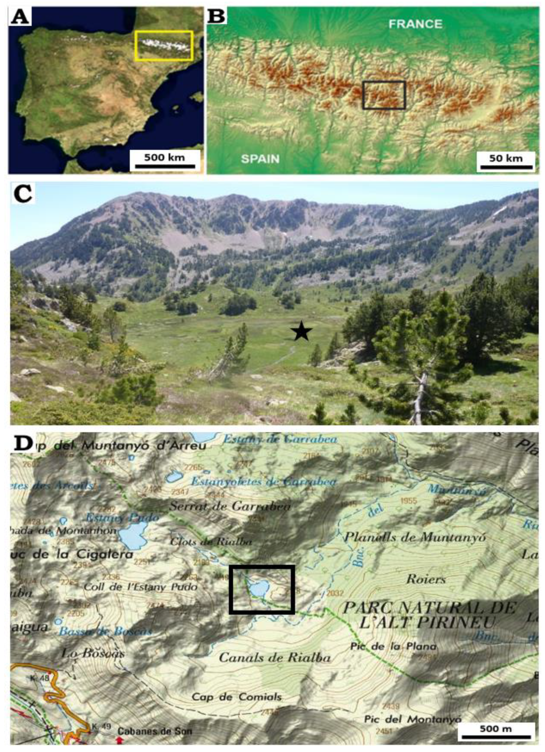
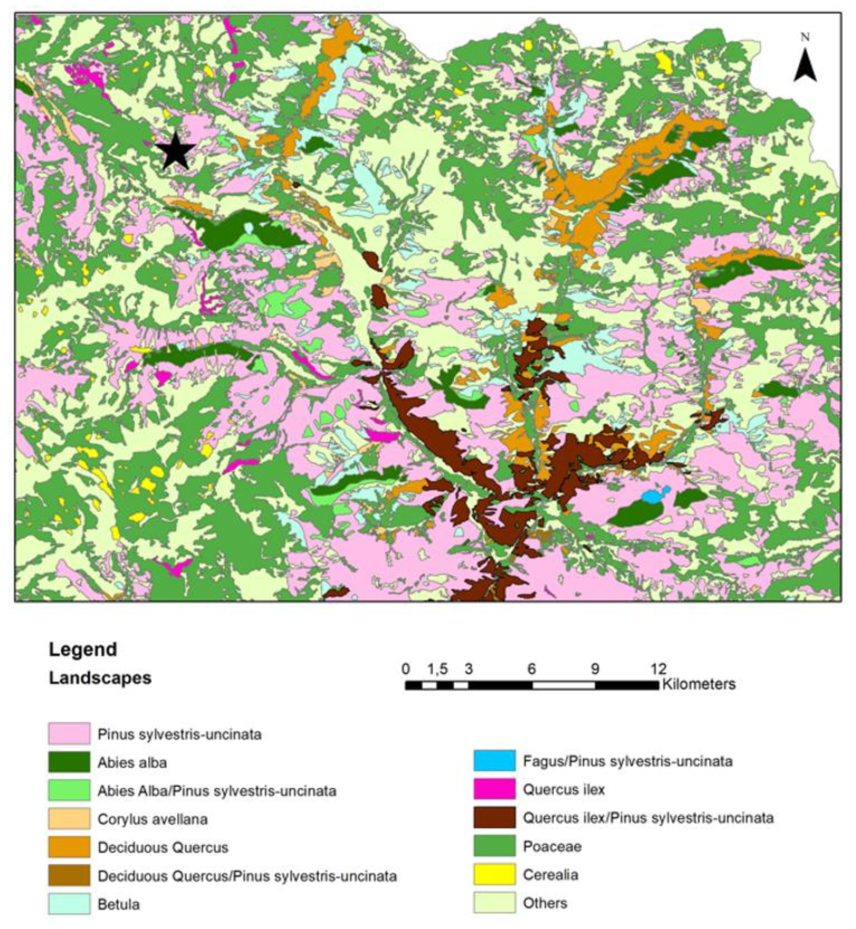
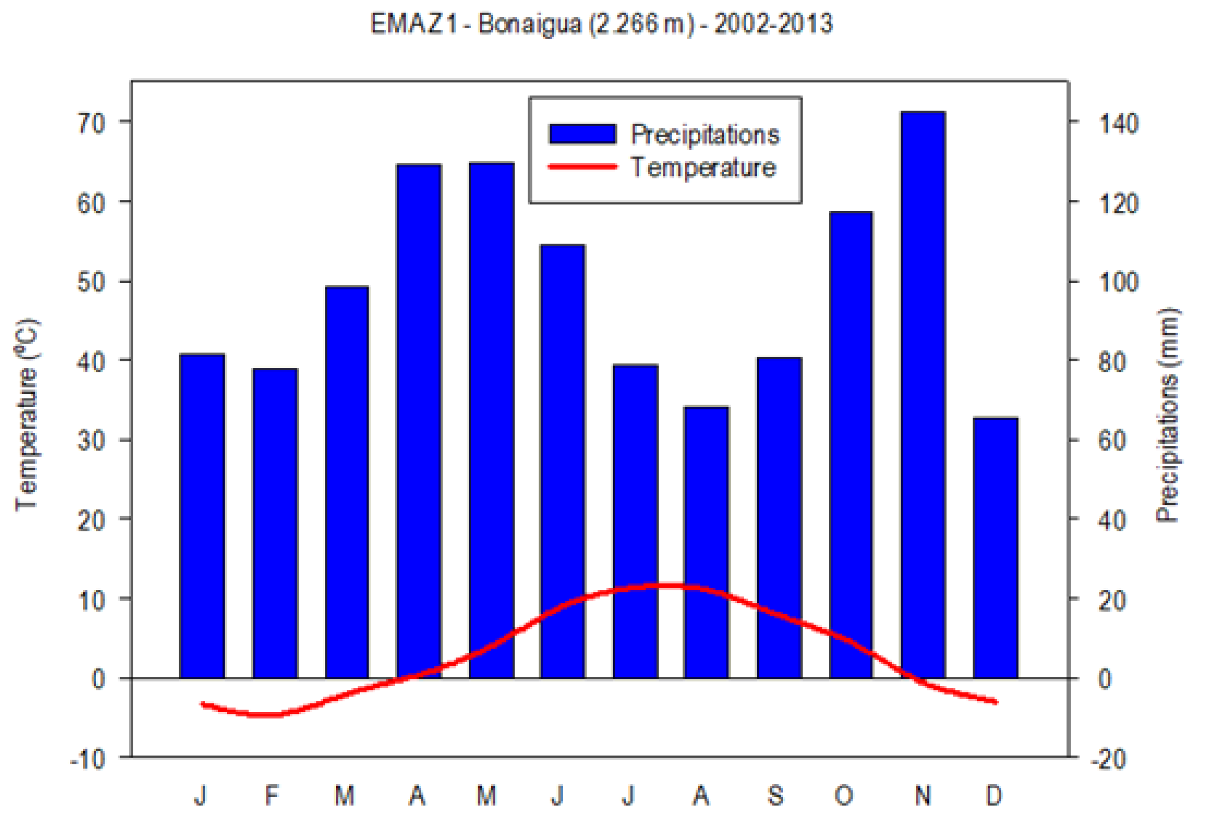
2. Study Area
3. Materials and Methods
3.1. Samples
3.2. Chronology
3.3. Organic Material
3.4. Palynology
3.5. Sedimentary Charcoals
4. Results
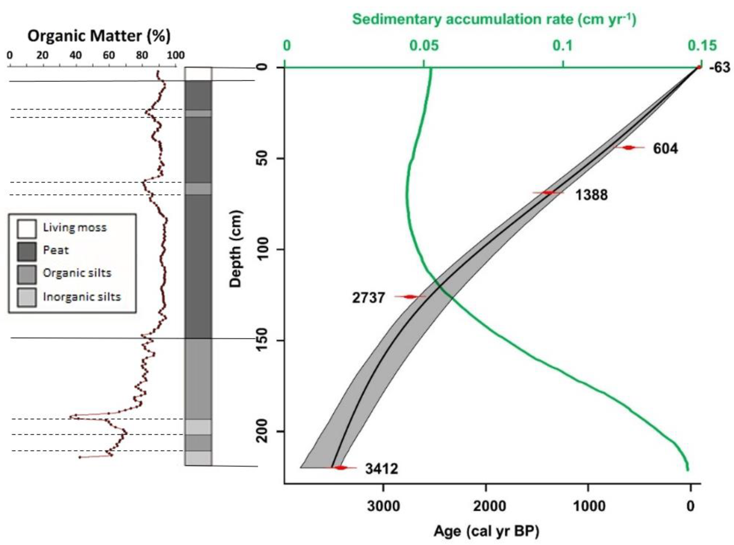
4.1. Sedimentary Description and Organic Matter
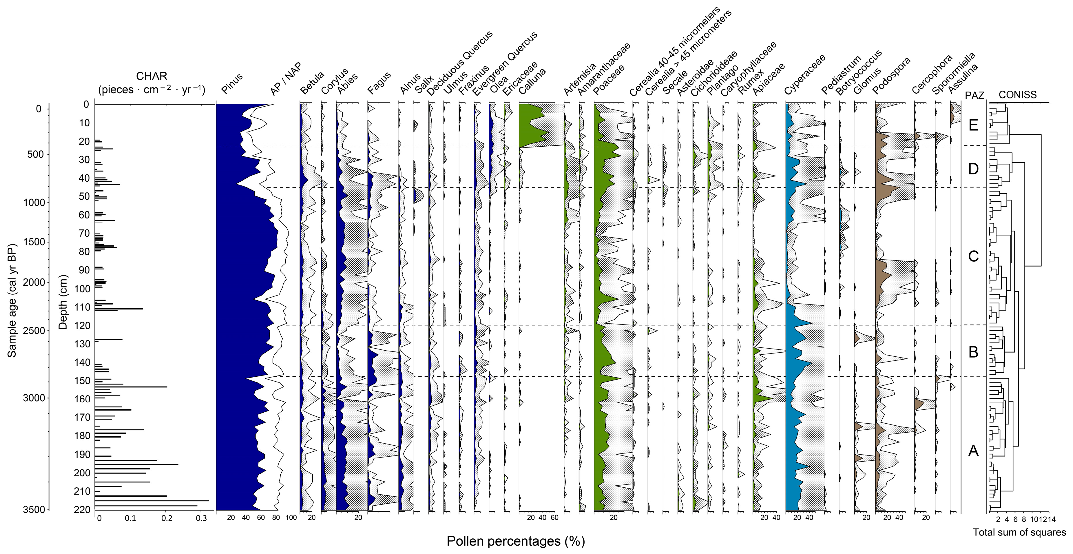
4.2. Pollen and Sedimentary Charcoals (>150 µm)
4.2.1. CdR1-APAZ. from c. 3500 to 2850 cal yr BP
4.2.2. CdR1-BPAZ. from c. 2850 to 2500 cal yr BP
4.2.3. CdR1-CPAZ. from c. 2500 to 800 cal yr BP
4.2.4. CdR1-DPAZ. from c. 800 to 450 cal yr BP
4.2.5. CdR1-EPAZ. from c. 450 cal yr BP to the Present Day
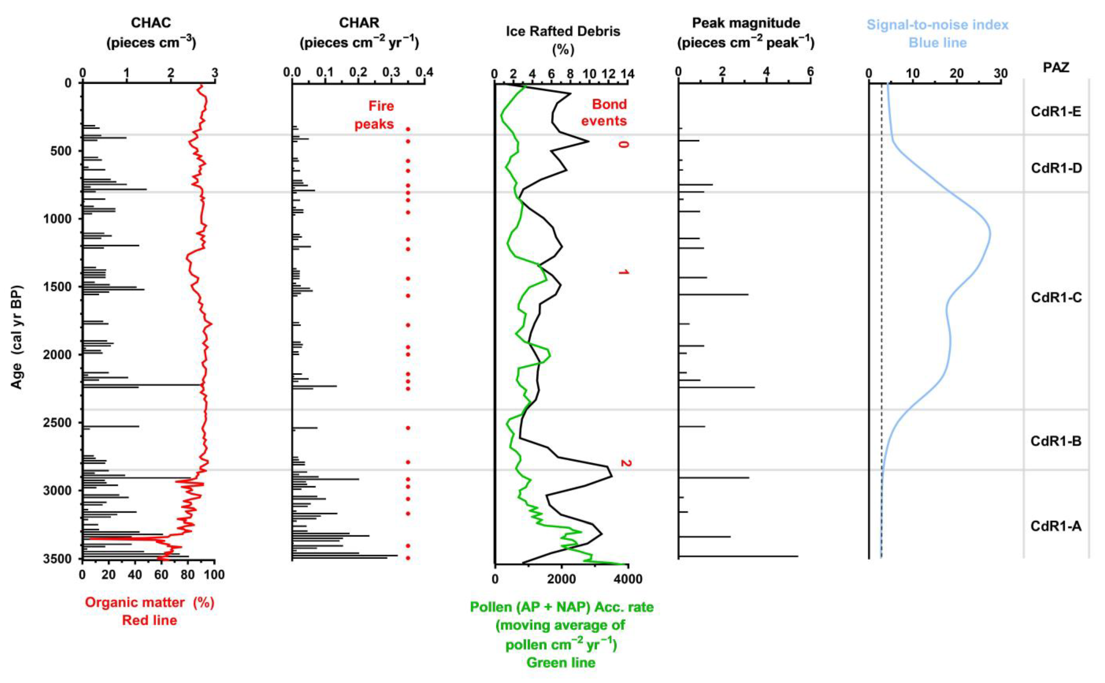
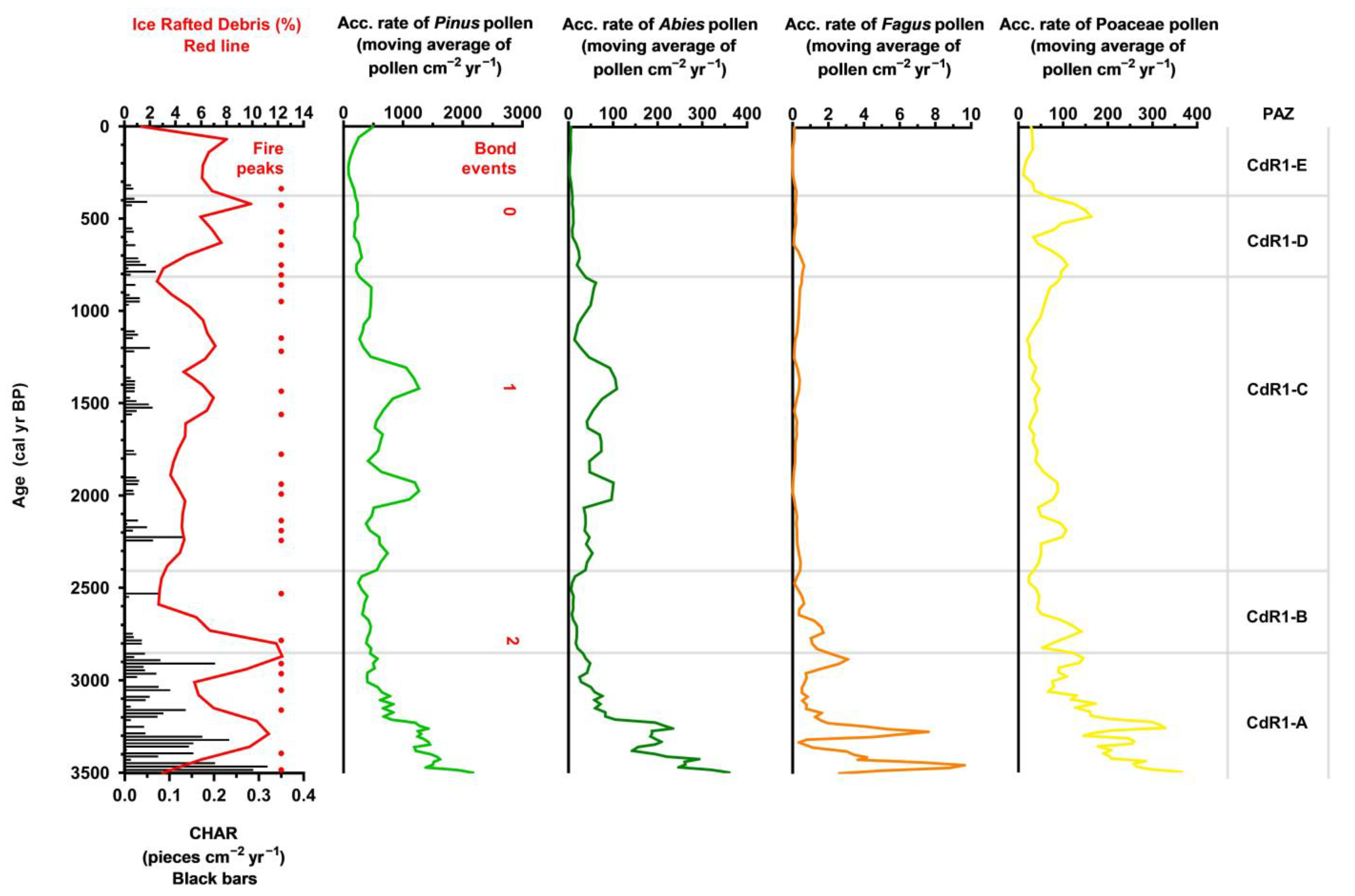
5. Discussion
5.1. Landscape Evolution from the Bronze Age to the Iron Age (from c. 3500 to 2200 cal yr BP)
5.2. Landscape Evolution during the Roman Period (from c. 2200 to 1500 cal yr BP)
5.3. Landscape Evolution during the Medieval Ages and the Little Ice Age (from c. 1500 cal yr BP to the Present)
6. Conclusions
Author Contributions
Funding
Institutional Review Board Statement
Informed Consent Statement
Data Availability Statement
Acknowledgments
Conflicts of Interest
References
- Pèlachs, A.; Soriano, J.M.; Nadal, J. Holocene environmental history and human impact in the Pyrenees. Contrib. Sci. 2007, 3, 421–429. [Google Scholar]
- Pèlachs, A.; Pérez-Obiol, R.; Ninyerola, M. Landscape dynamics of Abies and Fagus in the southern Pyrenees during the last 2200 years as a result of anthropogenic impacts. Rev. Palaeobot. Palynol. 2019, 156, 337–349. [Google Scholar] [CrossRef]
- Rodríguez-González, J.M.; Pérez-Obiol, R.; Pèlachs, A.; Cunill, R.; Soriano, J.M. Dinàmica del clima y del paisaje del Pirineo de Lleida durante la transición Tardiglaciar-Holoceno. La secuencia de Estanilles. In El Cuaternario en España y Áreas Afines. Avances en 2011; Turu, V., Constante, A., Eds.; Imprenta Envalira: Andorra la Vella, Andorra, 2011; pp. e287–e290. [Google Scholar]
- Catalan, J.; Pla, S.; García, J.; Camarero, L. Climate and CO2 saturation in an alpine lake throughout the Holocene. Limnol. Oceanogr. 2009, 54, 2542–2552. [Google Scholar] [CrossRef] [Green Version]
- Catalan, J.; Pèlachs, A.; Gassiot, E. Interacción entre clima y ocupación humana en la configuración del paisaje vegetal del Parque Nacional de Aigüestortes i Estany de Sant Maurici a lo largo de los últimos 15.000 años. In Proyectos de Investigación en Parques Nacionales; OPAN: Madrid, Spain, 2013; pp. 71–92. [Google Scholar]
- Rull, V.; González-Sampériz, P.; Corella, J.P. Vegetation changes in the southern Pyrenean flank during the last millennium in relation to climate and human activities: The Montcortès lacustrine record. J. Paleolimnol. 2011, 46, 387–404. [Google Scholar] [CrossRef] [Green Version]
- Rull, V.; Vegas-Vilarrúbia, T.; Corella, J.P. Bronze Age to Medieval vegetation dynamics and landscape anthropization in the central pre-Pyrenees. Res. Sq. Prepr. 2021, 571, 110392. [Google Scholar]
- Garces-Pastor, S.; Canellas-Bolta, N.; Clavaguera, A.; Calero, M.A.; Vegas-Vilarrubia, T. Vegetation shifts, human impact and peat bog development in Bassa Nera pond (Central Pyrenees) during the last millennium. Holocene 2017, 27, 553–565. [Google Scholar] [CrossRef]
- Gassiot, E.; Mazzucco, N.; Obea, L.; Tarifa Mateo, N.; Antolín i Tutusaus, F.; Clop García, X.; Navarrete, V.; Saña-Seguí, M. La Cova del Sardo de Boí i L’explotació de l’alta Muntanya als Pirineus Occidentals en Època Neolítica; UAB, Dipòsit Digital de Documents de la UAB, Cerdanyola del Vallès: Barcelona, Spain, 2015. [Google Scholar]
- Gil-Romera, G.; González-Sampériz, P.; Lasheras-Álvarez, L.; Sevilla-Callejo, M.; Moreno, A.; Valero-Garcés, B.; López-Merino, L.; Carrión, J.S.; Pérez Sanz, A. Biomass-modulated fire dynamics during the Last Glacial–Interglacial Transitionat the Central Pyrenees (Spain). Palaeogeogr. Palaeoclimatol. Palaeoecol. 2014, 402, 113–124. [Google Scholar] [CrossRef] [Green Version]
- Leunda, M.; González-Sampériz, P.; Gil-Romera, G.; Aranbarri, J.; Moreno, A.; Oliva-Urcia, B.; Sevilla-Callejo, M.; Valero-Garcés, B. The Late-Glacial and Holocene Marboré Lake sequence (2612 m a.s.l., Central Pyrenees, Spain): Testing high altitude sites sensitivity to millennial scale vegetation and climate variability. Glob. Planet. Change 2017, 157, 214–231. [Google Scholar] [CrossRef] [Green Version]
- Bond, G.; Showers, W.; Cheseby, M.; Lotti, R.; Almasi, P.; DeMenocal, P.; Priore, P.; Cullen, H.; Hajdas, I.; Bonani, G. A Pervasive Millennial-Scale Cycle in North Atlantic Holocene and Glacial Climates. Science 1997, 278, 1257–1266. [Google Scholar] [CrossRef]
- Bond, G.; Kromer, B.; Beer, J.; Muscheler, R.; Evans, M.N.; Showers, W.; Hoffmann, S.; Lotti-Bond, R.; Hajdas, I.; Bonani, G. Persistent solar influence on North Atlantic climate during the Holocene. Science 2001, 294, 2130–2136. [Google Scholar] [CrossRef] [Green Version]
- Baldini, L.M.; Baldini, J.U.; McDermott, F.; Arias, P.; Cueto, M.; Fairchild, I.J.; Hoffmann, D.L.; Mattey, D.P.; Müller, W.; Nita, D.C.; et al. North Iberian temperature and rainfall seasonality over the younger Dryas and Holocene. Quat. Sci. Rev. 2019, 226, 105998. [Google Scholar] [CrossRef]
- Mayewski, P.A.; Rohling, E.J.; Stager, J.C.; Karlén, W.; Maasch, K.; Meeker, L.D.; Meyerson, E.; Gasse, F.; Van Kreveld, S.; Holmgren, K.; et al. Holocene climate variability. Quat. Res. 2004, 62, 243–255. [Google Scholar] [CrossRef]
- Wanner, H.; Buetikofer, J. Holocene Bond cycles: Real or imaginary. Geografie 2008, 113, 338–349. [Google Scholar] [CrossRef]
- Isono, D.; Yamamoto, M.; Irino, T.; Oba, T.; Murayama, M.; Nakamura, T.; Kawahata, H. The 1500-year climate oscillation in the midlatitude North Pacific during the Holocene. Geology 2009, 37, 591–594. [Google Scholar] [CrossRef]
- Wanner, H.; Solomina, O.; Grosjean, M.; Ritz, S.P.; Jetel, M. Structure and origin of Holocene cold events. Quat. Sci. Rev. 2011, 30, 3109–3123. [Google Scholar] [CrossRef]
- Zielhofer, C.; Köhler, A.; Mischke, S.; Benkaddour, A.; Mikdad, A.; Fletcher, W.J. Western Mediterranean hydro-climatic consequences of Holocene ice-rafted debris (Bond) events. Clim. Past. 2019, 15, 463–475. [Google Scholar] [CrossRef] [Green Version]
- Sancho, C.; Belmonte, Á.; Bartolomé, M.; Moreno, A.; Leunda, M.; López-Martínez, J. Middle-to-late Holocene palaeoenvi-ronmental reconstruction from the A294 ice-cave record (Central Pyrenees, northern Spain). Earth Planet. Sci. Lett. 2018, 484, 135–144. [Google Scholar] [CrossRef] [Green Version]
- Pèlachs, A.; Julià, R.; Pérez-Obiol, R.; Soriano, J.M.; Bal, M.C.; Cunill, R.; Catalan, J. Potential influence of Bond events on mid-Holocene climate and vegetation in southern Pyrenees as assessed from Burg lake LOI and pollen records. Holocene 2011, 21, 95–104. [Google Scholar] [CrossRef]
- Pla, S.; Catalan, J. Chrysophyte cysts from lake sediments reveal the submillennial winter/spring climate variability in the northwestern Mediterranean region throughout the Holocene. Clim. Dyn. 2005, 24, 263–278. [Google Scholar] [CrossRef]
- Corella, J.P.; Amrani, A.; Sigró, J.; Morellón, M.; Rico, E.; Valero-Garcés, B. Recent evolution of Lake Arreo, northern Spain: Influences of land use change and climate. J. Paleolimnol. 2011, 46, 469–485. [Google Scholar] [CrossRef]
- Corella, J.P.; Valero-Garcés, B.; Moreno, A.; Morellón, M.; Rull, V.; Giralt, S.; Rico, M.T.; Pérez-Sanz, A. Climate and human impact on a meromictic lake during the last 6000 years (Montcortès Lake, Central Pyrenees, Spain). J. Paleolimnol. 2011, 46, 351–367. [Google Scholar] [CrossRef] [Green Version]
- Morellón, M.; Valero-Garcés, B.; González-Sampériz, P.; VegasVilarrúbia, T.; Rubio, E.; Rieradevall, M.; Delgado-Huertas, A.; Mata, P.; Romero, Ó.; Engstrom, D.R.; et al. Climate changes and human activities recorded in the sediments of Lake Estanya (NE Spain) during the Medieval Warm Period and Little Ice Age. J. Paleolimnol. 2011, 46, 423–452. [Google Scholar] [CrossRef]
- Moreno, A.; Valero-Garcés, B.L.; González-Sampériz, P.; Rico, M. Flood response to rainfall variability during the last 2000 years inferred from the Taravilla Lake record (Central Iberian Range, Spain). J. Paleolimnol. 2008, 40, 943–961. [Google Scholar] [CrossRef] [Green Version]
- Pérez Sanz, A.; González-Sampériz, P.; Valero-Garcés, B.; Moreno, A.; Morellón, M.; Sancho, C.; Belmonte, A.; Gil-Romera, G.; Sevilla, M.; Navas, A. Clima y actividades humanas en la dinámica de la vegetación durante los últimos 2000 años en el Pirineo Central: El registro palinológico de la Basa de la Mora (Macizo de Cotiella). Zubia 2011, 23, 17–38. [Google Scholar]
- Pla-Rabes, S.; Catalan, J. Deciphering chrysophyte responses to climate seasonality. J. Paleolimnol. 2011, 46, 139–150. [Google Scholar] [CrossRef]
- Büntgen, U.; Trouet, V.; Frank, D.; Leuschner, H.H.; Friedrichs, D.; Luterbacher, J.; Esper, J. Tree-ring indicators of German summer drought over the last millennium. Quat. Sci. Rev. 2008, 29, 1005–1016. [Google Scholar] [CrossRef]
- Morellón, M.; Pérez-Sanz, A.; Corella, J.P.; Büntgen, U.; Catalán, J.; González-Sampériz, P.; González-Trueba, J.J.; López-Sáez, J.A.; Moreno, A.; Pla-Rabes, S.; et al. A multi-proxy perspective on millennium-long climate variability in the Southern Pyrenees. Clim. Past 2012, 8, 683–700. [Google Scholar] [CrossRef] [Green Version]
- González Sampériz, P.; Montes, L.; Lasanta, T.; Aranbarri, J.; Sanjuán, Y.; Laborda, R.; Sanjuán, Y.; Gil-Romera, G.; Lasanta, T.; Leunda, M. Escenarios, tempo e indicadores paleoambientales para la identificación del Antropoceno en el paisaje vegetal del Pirineo Central (NE Iberia). Cuad. De Investig. Geográfica 2019, 45, 167–193. [Google Scholar] [CrossRef] [Green Version]
- Domínguez-Villar, D.; Wang, X.; Krklec, K.; Cheng, H.; Edwards, R.L. The control of the tropical North Atlantic on Holocene millennial climate oscillations. Geology 2017, 45, 303–306. [Google Scholar] [CrossRef]
- López-Sáez, J.A.; López-Merino, L.; Mateo, M.Á.; Serrano, Ó.; Pérez-Díaz, S.; Serrano, L. Palaeoecological potential of the marine organic deposits of Posidonia oceanica: A case study in the NE Iberian Peninsula. Palaeogeogr. Palaeoclimatol. Palaeoecol. 2009, 271, 215–224. [Google Scholar] [CrossRef]
- Mazzucco, N.; Clemente Conte, I.; Gassiot, E. Lost in the mountains? The Cova del Sardo and the Neolithisation of the Southern Central Pyrenees (fifth-third mill. cal BC). Archaeol. Anthropol. Sci. 2019, 11, 1461–1475. [Google Scholar] [CrossRef]
- Gassiot-Ballbè, E.; Díaz-Bonilla, S.; Salvador-Baiges, G.; Obea-Gómez, L.; Rodríguez-Antón, D.; Mazzucco, N. Des de la prehistòria fins a l’actualitat: Les ocupacions de l’Abric de les Obagues de Ratera, al Parc Nacional d’Aigüestortes i Estany de Sant Maurici (Espot). Segones Jornades D’arqueologia I Paleontol. Del Pirin. I Aran 2020, 90–97. Available online: https://ddd.uab.cat/record/239911 (accessed on 5 December 2022).
- Gassiot, E.; Rodríguez, D.; Pèlachs, A.; Pérez-Obiol, R.; Julià, R.; Bal, M.C.; Mazzucco, N. La alta montaña durante la Prehistoria: 10 años de investigación en el Pirineo catalán occidental. Trab. De Prehist. 2014, 71, 261–281. [Google Scholar] [CrossRef] [Green Version]
- Obea-Gómez, L.; Celma-Martinez, M.; Piqué-Huerta, R.; Gassiot-Ballbè, E.; MartinSeijo, M.; Salvador Baiges, G.; Rodríguez-Antón, D.; Quesada-Carrasco, M.; Mazzucco, N.; Garcia-Casas, D.; et al. Firewood-gathering strategies in high mountain areas of the Parc Nacional d’Aigüestortes i Estany de Sant Maurici (Central Pyrenees) during Prehistory. Quat. Int. 2021, 593–594, 129–143. [Google Scholar] [CrossRef]
- Bal, M.C.; Pelachs, A.; Perez-Obiol, R.; Julia, R.; Cunill, R. Fire history and human activities during the last 3300 cal yr BP in Spain’s Central Pyrenees: The case of the Estany de Burg. J. Palaeo 2011, 300, 179–190. [Google Scholar]
- Pérez-Obiol, R.; Bal, M.C.; Pèlachs, A.; Cunill, R.; Soriano, J.M. Vegetation dynamics and anthropogenically forced changes in the Estanilles peat bog (southern Pyrenees) during the last seven millennia. Veg. Hist. Archaeobotany 2012, 21, 385–396. [Google Scholar] [CrossRef]
- Blaauw, M. Methods and code for ‘classical’age-modelling of radiocarbon sequences. Quat. Geochronol. 2010, 5, 512–518. [Google Scholar] [CrossRef]
- Watkins, M.W. A Step-by-Step Guide to Exploratory Factor Analysis with R and RStudio; Routledge: New York, NY, USA, 2020. [Google Scholar]
- Reimer, P.J.; Austin, W.E.; Bard, E.; Bayliss, A.; Blackwell, P.G.; Ramsey, C.B.; Butzin, M.; Cheng, H.; Edwards, L.; Friedrich, M.; et al. The IntCal20 Northern Hemisphere radiocarbon age calibration curve (0–55 cal kBP). Radiocarbon 2020, 62, 725–757. [Google Scholar] [CrossRef]
- Dean, W.E. Determination of carbonate and organic matter in calcareous sediments and sedimentary rocks by loss on ignition; comparison with other methods. J. Sediment. Res. 1974, 44, 242–248. [Google Scholar]
- Heiri, O.; Lotter, A.F.; Lemcke, G. Loss on ignition as a method for estimating organic and carbonate content in sediments: Reproducibility and comparability of results. J. Paleolimnol. 2001, 25, 101–110. [Google Scholar] [CrossRef]
- Stockmarr, J. Tables with spores used in absolute pollen analysis. Pollen Spores 1971, 13, 615–621. [Google Scholar]
- Faegri, K.; Iversen, J.; Kaland, P.E.; Krzywinski, K. Textbook of Pollen Analysis; Blackburn Press: Caldwell, NJ, USA, 1989. [Google Scholar]
- Moore, P.D.; Webb, J.A.; Collison, M.E. Pollen Analysis, 2nd ed.; Blackwell Scientific Publications: Oxford, UK, 1991; pp. 1–216. [Google Scholar]
- Bennett, K.D.; Willis, K.J. Pollen. In Tracking Environmental Change Using Lake Sediments; Springer: Dordrecht, The Netherlands, 2002; pp. 5–32. [Google Scholar]
- Reille, M. Pollen et Spores d’europe et d’afrique du Nord; Laboratoire de Botanique historique et Palynologie: Marseille, France, 1992; 543p. [Google Scholar]
- Van Geel, B.; Aptroot, A. Fossil ascomycetes in Quaternary deposits. Nova Hedwig. 2006, 82, 313–330. [Google Scholar] [CrossRef]
- Grimm, E.C. Tilia and tiliagraph. Illinois State Museum; Research and Collections Center: Springfield, IL, USA, 1991; Volume 101.
- Grimm, E.C. TILIA 2.0.b.4 (Computer software). Illinois State Museum; Research and Collections Center: Springfield, IL, USA, 1993.
- Grimm, E.C. CONISS: A Fortran 77 program for stratigraphically constrained cluster analysis by the method of incremental sum of squares. Comput. Geosci. 1987, 13, 13–35. [Google Scholar] [CrossRef]
- Carcaillet, C.; Bouvier, M.; Fréchette, B.; Larouche, A.C.; Richard, P.J. Comparison of pollen-slide and sieving methods in lacustrine charcoal analyses for local and regional fire history. Holocene 2001, 11, 467–476. [Google Scholar] [CrossRef]
- Carcaillet, C.; Bergman, I.; Delorme, S.; Hornberg, G.; Zackrisson, O. Long-term fire frequency not linked to prehistoric occupations in northern Swedish boreal forest. Ecology 2007, 88, 465–477. [Google Scholar] [CrossRef] [PubMed]
- Finsinger, W.; Kelly, R.; Fevre, J.; Magyari, E.K. A guide to screening charcoal peaks in macrocharcoal-area records for fire-episode reconstructions. Holocene 2014, 24, 1002–1008. [Google Scholar] [CrossRef]
- Kelly, R.F.; Higuera, P.E.; Barrett, C.M.; Hu, F.S. Short paper: A signal-to-noise index to quantify the potential for peak detection in sediment–charcoal records. Quat. Res. 2011, 75, 11–17. [Google Scholar] [CrossRef]
- Higuera, P. CharAnalysis 0.9: Diagnostic and Analytical Tools for Sediment-Charcoal Analysis; User’s Guide, Montana State University: Bozeman, MT, USA, 2009. [Google Scholar]
- Fletcher, W.J.; Zielhofer, C. Fragility of Western Mediterranean landscapes during Holocene rapid climate changes. Catena 2013, 103, 16–29. [Google Scholar] [CrossRef]
- Garcés-Pastor, S.; Cañellas-Boltà, N.; Pèlachs, A.; Soriano, J.M.; Pérez-Obiol, R.; Pérez-Haase, A.; Vegas-Vilarrúbia, T. Environmental history and vegetation dynamics in response to climate variations and human pressure during the Holocene in Bassa Nera, Central Pyrenees. Palaeogeogr. Palaeoclimatol. Palaeoecol. 2017, 479, 48–60. [Google Scholar] [CrossRef]
- Pèlachs, A.; Rodríguez-González, J.M.; Pérez-Obiol, R.; Julià, R.; Burjachs, F.; Expósito, I.; Yll, E.I. Dinámica del clima y del paisaje vegetal del pirineo de Lleida durante la transicion Tardiglaciar-Holoceno. Cuatern. Y Geomorfol. 2012, 26, 0079–0096. [Google Scholar]
- Olesti Vila, O.; Mercadal i Fernández, O. L’explotació dels territoris pirinencs orientals en època antiga. Treb. D’arqueologia 2017, 21, 9–47. [Google Scholar] [CrossRef] [Green Version]
- Büntgen, U.; Tegel, W.; Nicolussi, K.; McCormick, M.; Frank, D.; Trouet, V.; Kaplan, J.O.; Herzig, F.; Heussner, K.-U.; Wanner, H.; et al. 2500 years of European climate variability and human susceptibility. Science 2011, 331, 578–582. [Google Scholar] [CrossRef] [PubMed] [Green Version]
- Miller, G.H.; Geirsdóttir, Á.; Zhong, Y.; Larsen, D.J.; Otto-Bliesner, B.L.; Holland, M.M.; Bailey, D.A.; Refsnider, K.A.; Lehman, S.J.; Southon, J.R.; et al. Abrupt onset of the Little Ice Age triggered by volcanism and sustained by sea-ice/ocean feedbacks. Geophys. Res. Lett. 2012, 39, 2708. [Google Scholar] [CrossRef] [Green Version]
- Miras, Y.; Ejarque, A.; Orengo, H.; Mora, S.R.; Palet, J.M.; Poiraud, A. Prehistoric impact on landscape and vegetation at high altitudes: An integrated palaeoecological and archaeological approach in the eastern Pyrenees (Perafita valley, Andorra). Plant Biosyst. 2010, 144, 924–939. [Google Scholar] [CrossRef]


| Sample Code and Material | Depth (cm) | Lab Code | Conventional Dating BP | 13C/12C (‰) | Calibrated Age (2σ) (cal yr BP) | Median Probability Age, Used for Chronological Model (cal yr BP) |
|---|---|---|---|---|---|---|
| CdR1_M42, Plant material | 44 | Beta-420098 | 600 ± 30 | −27.2 | 649–543 | 604 |
| CdR1_M65, Plant material | 69 | Beta-420097 | 1520 ± 30 | −25.5 | 1514–1313 | 1388 |
| CdR1_M117, Plant material | 126 | Beta-420096 | 2590 ± 30 | −24.8 | 2543–2761 | 2737 |
| CdR1_M205, Plant material | 220 | Beta-371857 | 3190 ± 30 | −26.1 | 3455–3364 | 3412 |
Disclaimer/Publisher’s Note: The statements, opinions and data contained in all publications are solely those of the individual author(s) and contributor(s) and not of MDPI and/or the editor(s). MDPI and/or the editor(s) disclaim responsibility for any injury to people or property resulting from any ideas, methods, instructions or products referred to in the content. |
© 2023 by the authors. Licensee MDPI, Basel, Switzerland. This article is an open access article distributed under the terms and conditions of the Creative Commons Attribution (CC BY) license (https://creativecommons.org/licenses/by/4.0/).
Share and Cite
Rodríguez-González, J.-M.; Sánchez-Morales, M.; Nadal-Tersa, J.; Pèlachs, A.; Pérez-Obiol, R. Paleoenvironmental Reconstruction for the Last 3500 Years in the Southern Pyrenees from a Peat Bog Core in Clots de Rialba. Diversity 2023, 15, 390. https://doi.org/10.3390/d15030390
Rodríguez-González J-M, Sánchez-Morales M, Nadal-Tersa J, Pèlachs A, Pérez-Obiol R. Paleoenvironmental Reconstruction for the Last 3500 Years in the Southern Pyrenees from a Peat Bog Core in Clots de Rialba. Diversity. 2023; 15(3):390. https://doi.org/10.3390/d15030390
Chicago/Turabian StyleRodríguez-González, Josep-Manel, Marc Sánchez-Morales, Jordi Nadal-Tersa, Albert Pèlachs, and Ramon Pérez-Obiol. 2023. "Paleoenvironmental Reconstruction for the Last 3500 Years in the Southern Pyrenees from a Peat Bog Core in Clots de Rialba" Diversity 15, no. 3: 390. https://doi.org/10.3390/d15030390