


Idealized Simulations of a Supercell Interacting with an Urban Area

Abstract
:1. Introduction
2. Methodology
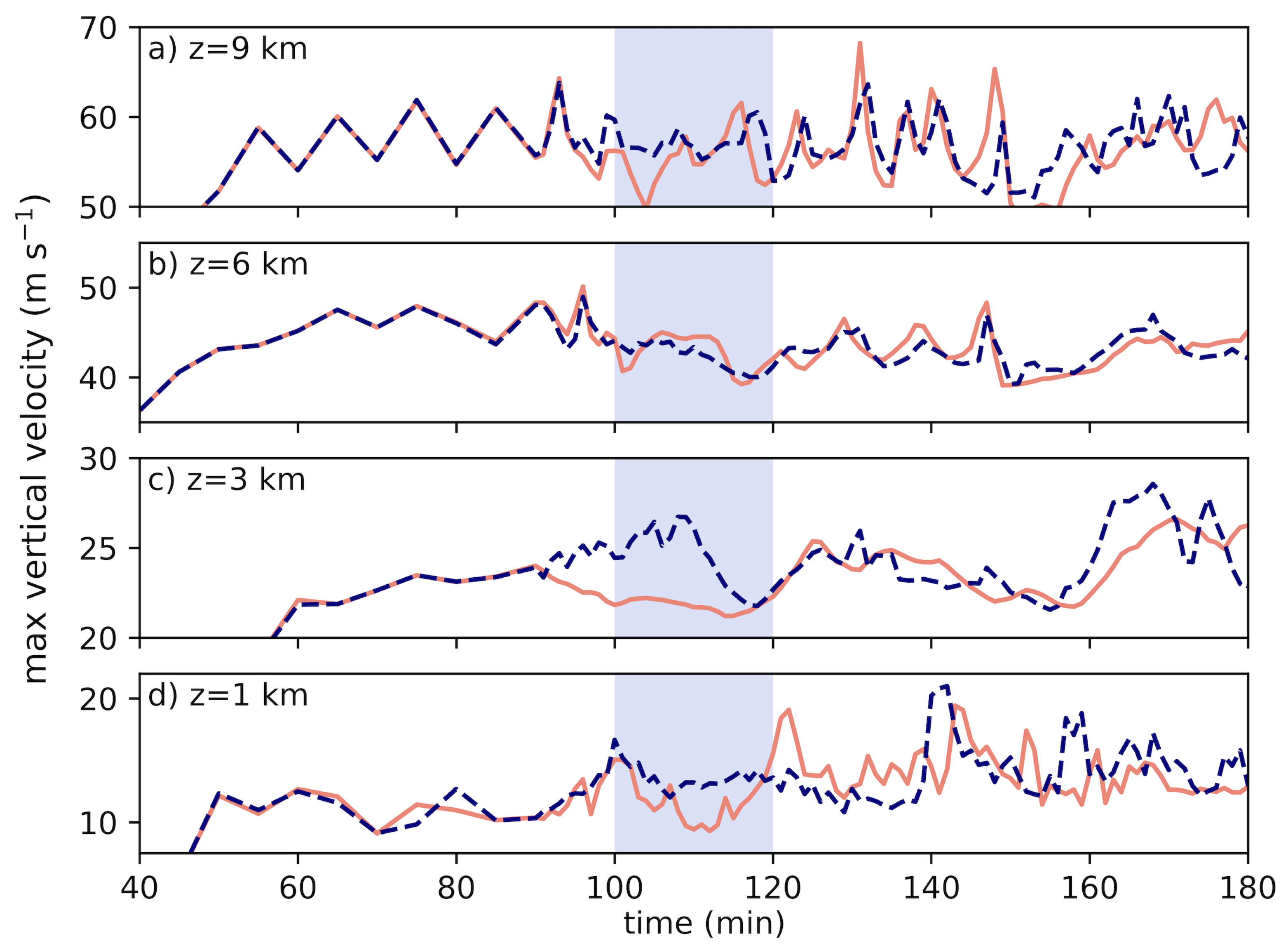
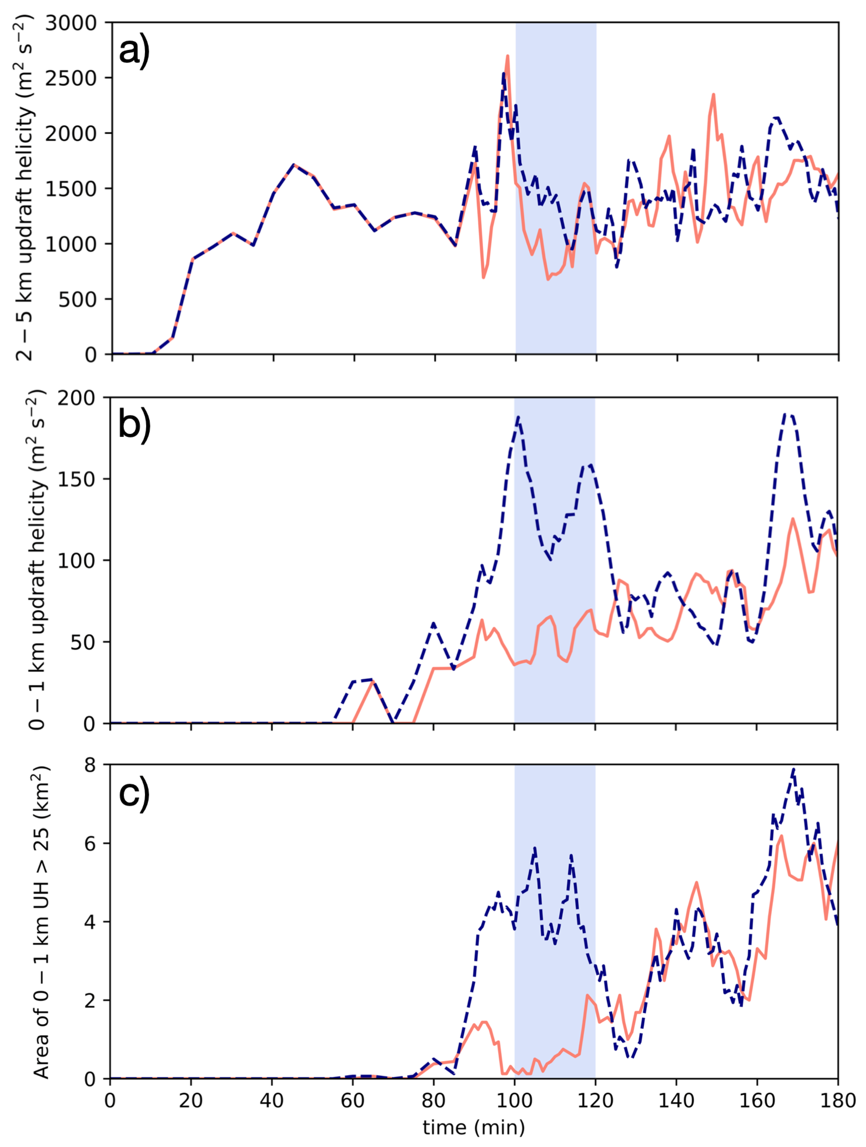
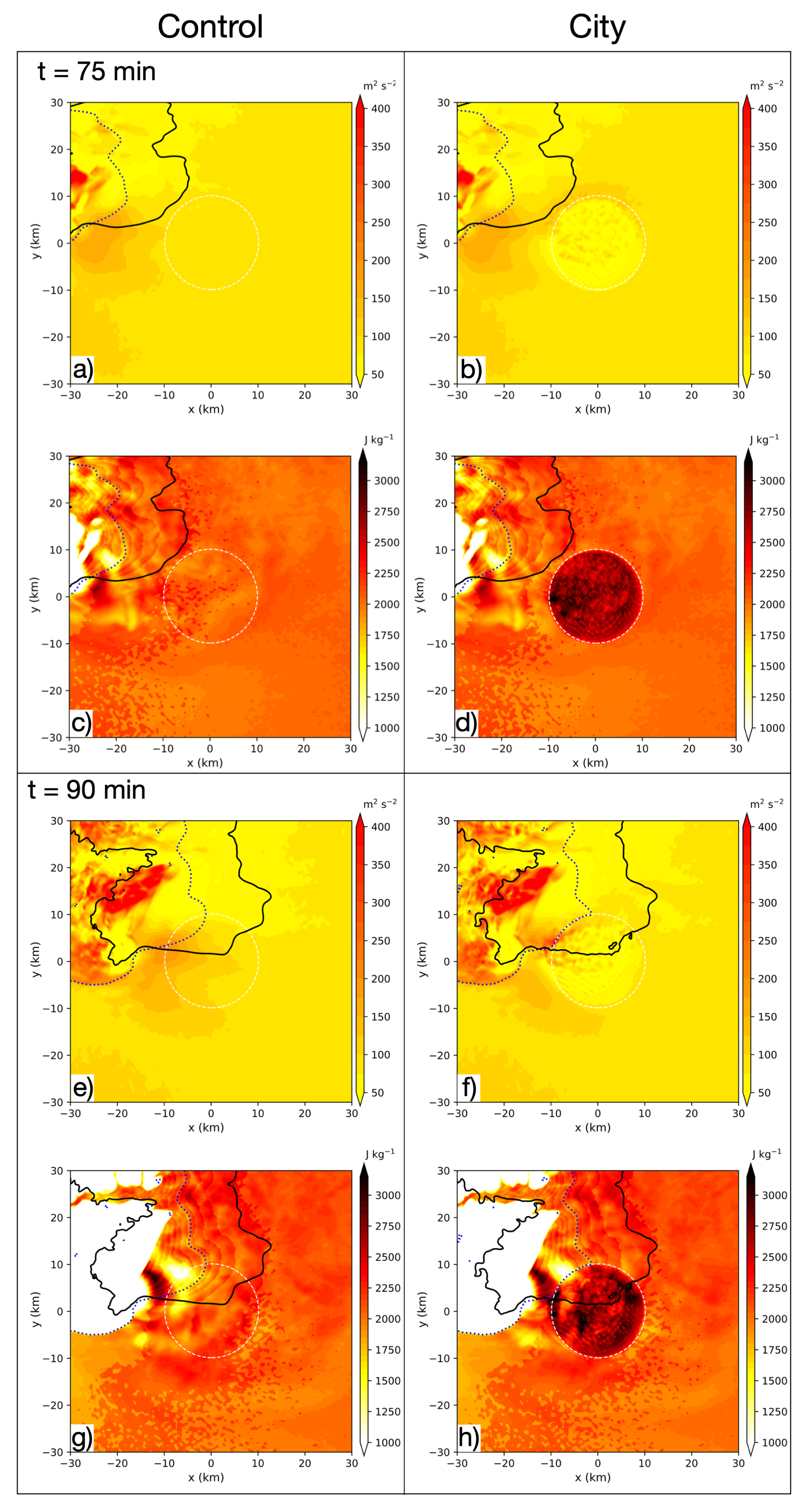
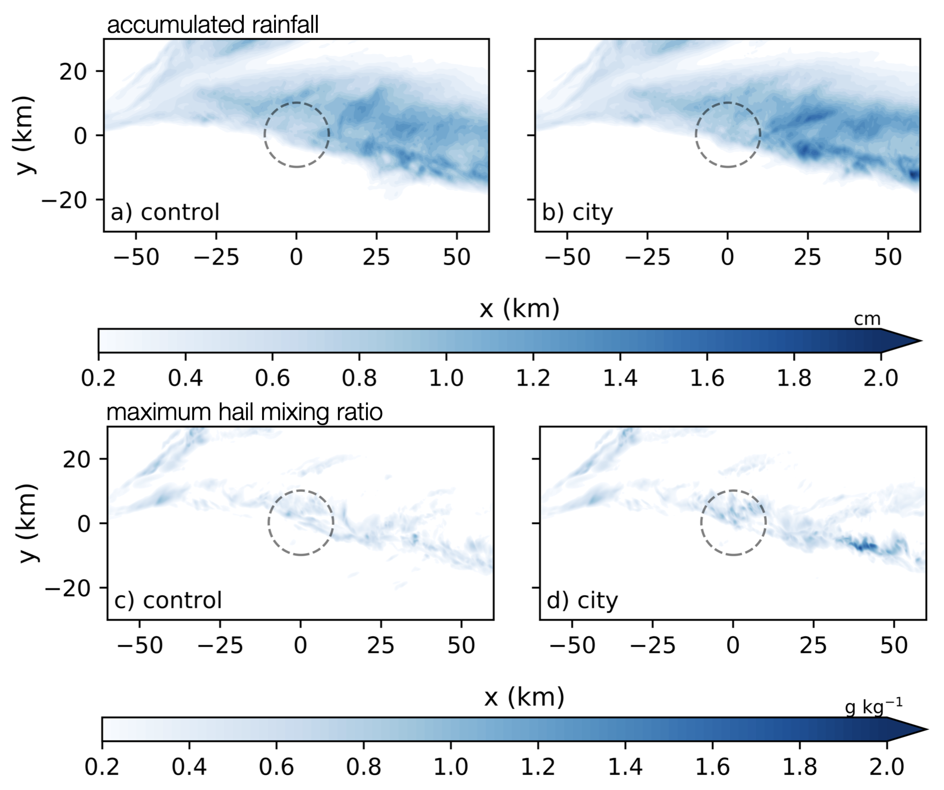
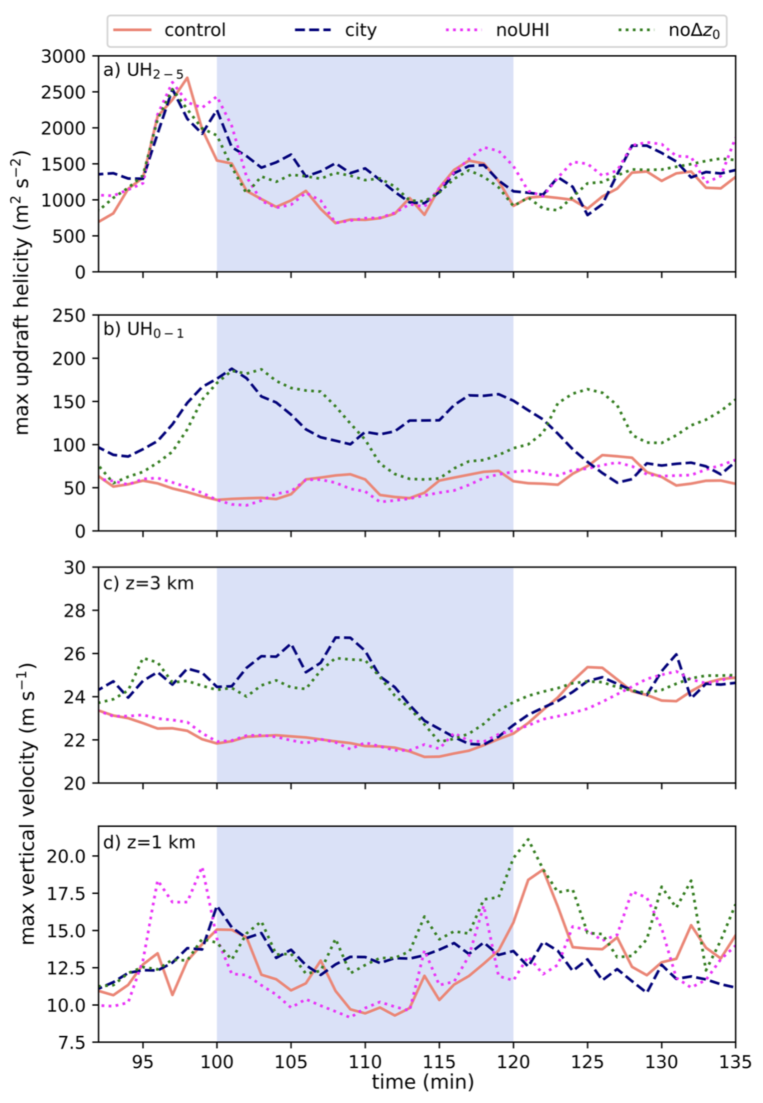
3. Results
4. Summary and Conclusions
Author Contributions
Funding
Data Availability Statement
Acknowledgments
Conflicts of Interest
References
- Smith, B.T.; Thompson, R.L.; Grams, J.S.; Broyles, C.; Brooks, H.E. Convective modes for significant severe thunderstorms in the contiguous United States. Part I: Storm classification and climatology. Weather Forecast 2012, 27, 1114–1135. [Google Scholar] [CrossRef]
- Weisman, M.L.; Klemp, J.B. The dependence of numerically simulated convective storms on vertical wind shear and buoyancy. Mon. Weather Rev. 1982, 110, 504–520. [Google Scholar] [CrossRef]
- Weisman, M.L.; Klemp, J.B. The structure and classification of numerically simulated convective storms in directionally varying wind shears. Mon. Weather Rev. 1984, 112, 2479–2498. [Google Scholar] [CrossRef]
- Rasmussen, E.N.; Blanchard, D.O. A baseline climatology of sounding-derived supercell and tornado forecast parameters. Weather Forecast 1998, 13, 1148–1164. [Google Scholar] [CrossRef]
- Thompson, R.L.; Edwards, R.; Hart, J.A.; Elmore, K.L.; Markowski, P. Close proximity soundings within supercell environments obtained from the Rapid Update Cycle. Weather Forecast 2003, 18, 1243–1261. [Google Scholar] [CrossRef]
- Atkins, N.T.; Weisman, M.L.; Wicker, L.J. The influence of preexisting boundaries on supercell evolution. Mon. Weather Rev. 1999, 127, 2910–2927. [Google Scholar] [CrossRef]
- Richardson, Y.P.; Droegemeier, K.K.; Davies-Jones, R.P. The influence of horizontal environmental variability on numerically simulated convective storms. Part I: Variations in vertical shear. Mon. Weather Rev. 2007, 135, 3429–3455. [Google Scholar] [CrossRef]
- Ziegler, C.L.; Mansell, E.R.; Straka, J.M.; Macgorman, D.R.; Burgess, D.W. The impact of spatial variations of low-level stability on the life cycle of a simulated supercell storm. Mon. Weather Rev. 2010, 138, 1738–1766. [Google Scholar] [CrossRef]
- Coffer, B.E.; Parker, M.D. Impacts of increasing low-level shear on supercells during the early evening transition. Mon. Weather Rev. 2015, 143, 1945–1969. [Google Scholar] [CrossRef]
- Davenport, C.E.; Parker, M.D. Impact of environmental heterogeneity on the dynamics of a dissipating supercell thunderstorm. Mon. Weather Rev. 2015, 143, 4244–4277. [Google Scholar] [CrossRef]
- Magee, K.M.; Davenport, C.E. An observational analysis quantifying the distance of supercell-boundary interactions in the great plains. J. Oper. Meteorol. 2020, 8, 15–38. [Google Scholar] [CrossRef]
- Davenport, C.E. Environmental evolution of long-lived supercell thunderstorms in the Great Plains. Weather Forecast 2021, 36, 2187–2209. [Google Scholar] [CrossRef]
- Fischer, J.; Dahl, J.M.L. Supercell-External Storms and Boundaries Acting as Catalysts for Tornadogenesis. Mon. Weather Rev. 2023, 151, 23–38. [Google Scholar] [CrossRef]
- Markowski, P.M.; Dotzek, N. A numerical study of the effects of orography on supercells. Atmos. Res. 2011, 100, 457–478. [Google Scholar] [CrossRef]
- Scheffknecht, P.; Serafin, S.; Grubišić, V. A long-lived supercell over mountainous terrain. Q. J. R. Meteorol. Soc. 2017, 143, 2973–2986. [Google Scholar] [CrossRef]
- Mulholland, J.P.; Nesbitt, S.W.; Trapp, R.J. A case study of terrain influences on upscale convective growth of a supercell. Mon. Weather Rev. 2019, 147, 4305–4324. [Google Scholar] [CrossRef]
- Mulholland, J.P.; Nesbitt, S.W.; Trapp, R.J.; Peters, J.M. The influence of terrain on the convective environment and associated convective morphology from an idealized modeling perspective. J. Atmos. Sci. 2020, 77, 3929–3949. [Google Scholar] [CrossRef]
- Tang, B.; Vaughan, M.; Lazear, R.; Corbosiero, K.; Bosart, L.; Wasula, T.; Lee, I.; Lipton, K. Topographic and boundary influences on the 22 May 2014 Duanesburg, New York, tornadic supercell. Weather Forecast 2016, 31, 107–127. [Google Scholar] [CrossRef]
- Elsner, J.B.; Fricker, T.; Widen, H.M.; Castillo, C.M.; Humphreys, J.; Jung, J.; Rahman, S.; Richard, A.; Jagger, T.H.; Bhatrasataponkul, T.; et al. The relationship between elevation roughness and tornado activity: A spatial statistical model fit to data from the central great plains. J. Appl. Meteorol. Climatol. 2016, 55, 849–859. [Google Scholar] [CrossRef]
- Lyza, A.W.; Knupp, K.R. A background investigation of tornado activity across the Southern Cumberland Plateau Terrain system of Northeastern Alabama. Mon. Weather Rev. 2018, 146, 4261–4278. [Google Scholar] [CrossRef]
- Hua, Z.; Chavas, D.R. The empirical dependence of tornadogenesis on elevation roughness: Historical record analysis using Bayes’s law in Arkansas. J. Appl. Meteorol. Climatol. 2019, 58, 401–411. [Google Scholar] [CrossRef]
- Houser, J.B.; McGinnis, N.; Butler, K.M.; Bluestein, H.B.; Snyder, J.C.; French, M.M. Statistical and empirical relationships between tornado intensity and both topography and land cover using rapid-scan radar observations and a GIS. Mon. Weather Rev. 2020, 148, 4313–4338. [Google Scholar] [CrossRef]
- Kellner, O.; Niyogi, D. Land surface heterogeneity signature in tornado climatology? An illustrative analysis over Indiana, 1950–2012. Earth Interact. 2014, 18, 1–32. [Google Scholar] [CrossRef]
- Markert, A.; Griffin, R.; Knupp, K.; Molthan, A.; Coleman, T. A spatial pattern analysis of land surface roughness heterogeneity and its relationship to the initiation of weak tornadoes. Earth Interact. 2019, 23, 1–28. [Google Scholar] [CrossRef]
- Schenkman, A.D.; Xue, M.; Hu, M. Tornadogenesis in a high-resolution simulation of the 8 May 2003 Oklahoma City supercell. J. Atmos. Sci. 2014, 71, 130–154. [Google Scholar] [CrossRef]
- Roberts, B.; Xue, M.; Schenkman, A.D.; Dawson, D.T. The role of surface drag in tornadogenesis within an idealized supercell simulation. J. Atmos. Sci. 2016, 73, 3371–3395. [Google Scholar] [CrossRef]
- Fiedler, B.H. Axisymmetric tornado simulations with a semi-slip boundary. Fluids 2017, 2, 68. [Google Scholar] [CrossRef]
- Huff, F.A.; Changnon, S.A. Climatological assessment of urban effects on precipitation at St. Louis. J. Appl. Meteorol. 1972, 11, 823–842. [Google Scholar] [CrossRef]
- Huff, F.A.; Changnon, S.A. Precipitation modification by major urban areas. Bull. Am. Meteorol. Soc. 1973, 54, 1220–1232. [Google Scholar] [CrossRef]
- Shepherd, J.M.; Pierce, H.; Negri, A.J. Rainfall modification by major urban areas: Observations from spaceborne rain radar on the TRMM satellite. J. Appl. Meteorol. 2002, 41, 689–701. [Google Scholar] [CrossRef]
- Niyogi, D.; Pyle, P.; Lei, M.; Arya, S.P.; Kishtawal, C.M.; Shepherd, M.; Chen, F.; Wolfe, B. Urban modification of thunderstorms: An observational storm climatology and model case study for the Indianapolis urban region. J. Appl. Meteorol. Climatol. 2011, 50, 1129–1144. [Google Scholar] [CrossRef]
- Naylor, J. Idealized simulations of city-storm interactions in a two-dimensional framework. Atmosphere 2020, 11, 707. [Google Scholar] [CrossRef]
- Naylor, J.; Mulholland, J.P. The Impact of Vertical Wind Shear on the Outcome of Interactions Between Squall Lines and Cities. J. Geophys. Res. Atmos. 2023, 128, e2022JD037237. [Google Scholar] [CrossRef]
- Reames, L.J.; Stensrud, D.J. Influence of a Great Plains urban environment on a simulated supercell. Mon. Weather Rev. 2018, 146, 1437–1462. [Google Scholar] [CrossRef]
- Lin, Y.; Fan, J.; Jeong, J.H.; Zhang, Y.; Homeyer, C.R.; Wang, J. Urbanization-induced land and aerosol impacts on storm propagation and hail characteristics. J. Atmos. Sci. 2021, 78, 925–947. [Google Scholar] [CrossRef]
- Bryan, G.H.; Fritsch, J.M. A benchmark simulation for moist nonhydrostatic numerical models. Mon. Weather Rev. 2002, 130, 2917–2928. [Google Scholar] [CrossRef]
- Dahl, J.M. Near-ground rotation in simulated supercells: On the robustness of the baroclinic mechanism. Mon. Weather Rev. 2015, 143, 4929–4942. [Google Scholar] [CrossRef]
- Dawson, D.T.; Xue, M.; Shapiro, A.; Milbrandt, J.A.; Schenkman, A.D. Sensitivity of real-data simulations of the 3 May 1999 Oklahoma City tornadic supercell and associated tornadoes to multimoment microphysics. Part II: Analysis of buoyancy and dynamic pressure forces in simulated tornado-like vortices. J. Atmos. Sci. 2016, 73, 1039–1061. [Google Scholar] [CrossRef]
- Boyer, C.H.; Dahl, J.M. The mechanisms responsible for large near-surface vertical vorticity within simulated supercells and quasi-linear storms. Mon. Weather Rev. 2020, 148, 4281–4297. [Google Scholar] [CrossRef]
- Morrison, H.; Curry, J.A.; Khvorostyanov, V.I. A new double-moment microphysics parameterization for application in cloud and climate models. Part I: Description. J. Atmos. Sci. 2005, 62, 1665–1677. [Google Scholar] [CrossRef]
- Morrison, H.; Thompson, G.; Tatarskii, V. Impact of cloud microphysics on the development of trailing stratiform precipitation in a simulated squall line: Comparison of one- and two-moment schemes. Mon. Weather Rev. 2009, 137, 991–1007. [Google Scholar] [CrossRef]
- Fairall, C.W.; Bradley, E.F.; Hare, J.E.; Grachev, A.A.; Edson, J.B. Bulk parameterization of air–sea fluxes: Updates and verification for the COARE algorithm. J. Clim. 2003, 16, 571–591. [Google Scholar] [CrossRef]
- Donelan, M.A.; Haus, B.K.; Reul, N.; Plant, W.J.; Stiassnie, M.; Graber, H.C.; Brown, O.B.; Saltzman, E.S. On the limiting aerodynamic roughness of the ocean in very strong winds. Geophys. Res. Lett. 2004, 31, 1–5. [Google Scholar] [CrossRef]
- Weisman, M.L.; Rotunno, R. The use of vertical wind shear versus helicity in interpreting supercell dynamics. J. Atmos. Sci. 2000, 57, 1452–1472. [Google Scholar] [CrossRef]
- Kain, J.S.; Weiss, S.J.; Bright, D.R.; Baldwin, M.E.; Levit, J.J.; Carbin, G.W.; Schwartz, C.S.; Weisman, M.L.; Droegemeier, K.K.; Weber, D.; et al. Some practical considerations regarding horizontal resolution in the first generation of operational convection-allowing NWP. Weather Forecast 2008, 23, 931–952. [Google Scholar] [CrossRef]
- Sobash, R.A.; Kain, J.S.; Bright, D.R.; Dean, A.R.; Coniglio, M.C.; Weiss, S.J. Probabilistic forecast guidance for severe thunderstorms based on the identification of extreme phenomena in convection-allowing model forecasts. Weather Forecast 2011, 26, 714–728. [Google Scholar] [CrossRef]
- Naylor, J.; Gilmore, M.S.; Thompson, R.L.; Edwards, R.; Wilhelmson, R.B. Comparison of objective supercell identification techniques using an idealized cloud model. Mon. Weather Rev. 2012, 140, 2090–2102. [Google Scholar] [CrossRef]
- Sobash, R.A.; Schwartz, C.S.; Romine, G.S.; Weisman, M.L. Next-day prediction of tornadoes using convection-allowing models with 1-km horizontal grid spacing. Weather Forecast 2019, 34, 1117–1135. [Google Scholar] [CrossRef]
- Liu, J.; Niyogi, D. Meta-analysis of urbanization impact on rainfall modification. Sci. Rep. 2019, 9, 7301. [Google Scholar] [CrossRef]
- Chou, M.D.; Suarez, M.J. A Solar Radiation Parameterization for Atmospheric Studies, NASA Tech Report; NASA Goddard Space Flight Center: Greenbelt, MD, USA, 1999. [Google Scholar]
- Chou, M.D.; Suarez, M.J.; Liang, X.Z.; Yan, M.M.H.; Cote, C. A Thermal Infrared Radiation Parameterization for Atmospheric Studies, NASA Tech Report; NASA Goddard Space Flight Center: Greenbelt, MD, USA, 2001. [Google Scholar]
- Mansell, E.R.; Ziegler, C.L.; Bruning, E.C. Simulated electrification of a small thunderstorm with two-moment bulk microphysics. J. Atmos. Sci. 2010, 67, 171–194. [Google Scholar] [CrossRef]


| Parameter | t = 30 min | t = 60 min | t = 90 min |
|---|---|---|---|
| 0–1 SRH (mm2 s−2) | 75 (75) | 81 (81) | 82 (82) |
| 0–3 SRH (m2 s−2) | 187 (187) | 192 (192) | 192 (192) |
| 0–6 shear (m s−1) | 32 (32) | 32 (32) | 32 (32) |
| sbCAPE (J kg−1) | 2165 (2165) | 2198 (2198) | 2087 (2081) |
| sbCIN (J kg−1) | −49 (−49) | −49 (−49) | −51 (−51) |
| LCL (mb) | 894 (894) | 894 (894) | 894 (894) |
| Name | Description |
|---|---|
| control_rad | Short-wave and long-wave radiation are parameterized using the NASA Goddard scheme [50,51]. |
| city_rad | |
| control_nssl | Microphysics are represented using the NSSL double-moment scheme [52]. |
| city_nssl | |
| control_west | Initial warm bubble perturbation is shifted 5 km to the west. |
| city_west | |
| city_pert | Skin temperature perturbation is set to 5.2 K and surface roughness length over the city is 2.1 m. |
Disclaimer/Publisher’s Note: The statements, opinions and data contained in all publications are solely those of the individual author(s) and contributor(s) and not of MDPI and/or the editor(s). MDPI and/or the editor(s) disclaim responsibility for any injury to people or property resulting from any ideas, methods, instructions or products referred to in the content. |
© 2024 by the authors. Licensee MDPI, Basel, Switzerland. This article is an open access article distributed under the terms and conditions of the Creative Commons Attribution (CC BY) license (https://creativecommons.org/licenses/by/4.0/).
Share and Cite
Naylor, J.; Berry, M.E.; Gosney, E.G. Idealized Simulations of a Supercell Interacting with an Urban Area. Meteorology 2024, 3, 97-113. https://doi.org/10.3390/meteorology3010005
Naylor J, Berry ME, Gosney EG. Idealized Simulations of a Supercell Interacting with an Urban Area. Meteorology. 2024; 3(1):97-113. https://doi.org/10.3390/meteorology3010005
Chicago/Turabian StyleNaylor, Jason, Megan E. Berry, and Emily G. Gosney. 2024. "Idealized Simulations of a Supercell Interacting with an Urban Area" Meteorology 3, no. 1: 97-113. https://doi.org/10.3390/meteorology3010005