1. Introduction
There are numerous effects that the scientific community has managed to associate with climate change, with those related to the problem of floods being some of the most dangerous. Among the areas of the planet where these changes are forcing administrations to rethink the methodologies to address this problem are the Spanish Mediterranean regions. There, the appearance of new cold-drop phenomena called DANA (Spanish acronym for upper-level isolated atmospheric depression) has replaced the traditional flash floods associated with historical fall storm events.
In these regions, a great process of territorial anthropization has developed in recent decades. The Mediterranean area is undoubtedly the region in which tourism, agriculture, infrastructure expansion, etc., has experienced the greatest degree of growth in recent decades. However, it is not easy to assess how this new phenomenon of anthropization directly affects the growing problem of flooding in a territory. Phenomena of a diffuse nature and with a rather indirect impact, such as the sealing effect of the soil due to urbanization processes of the land, orographic alterations produced by changes in land use and dam micro-effects that linear communication infrastructures can generate currently do not have specific methodological approaches in the traditional scientific literature. Several approaches for specific case studies can be found, but comprehensive large-scale evaluation methods from a territorial point of view are still lacking.
This study raises an innovative methodological approach based on the assessment of GIS indicators using geostatistics and nature-based solutions as a mitigation strategy. This new method assesses the spatial correlation between the territorial transformation derived from anthropic procedures with the growing risk of a territory to floods. To evaluate this new framework, the proposal is applied to the Campo de Cartagena area in south-eastern Spain, experiencing devastating floods in the last decade.
2. Area of Study and Methodology
2.1. Area of Study
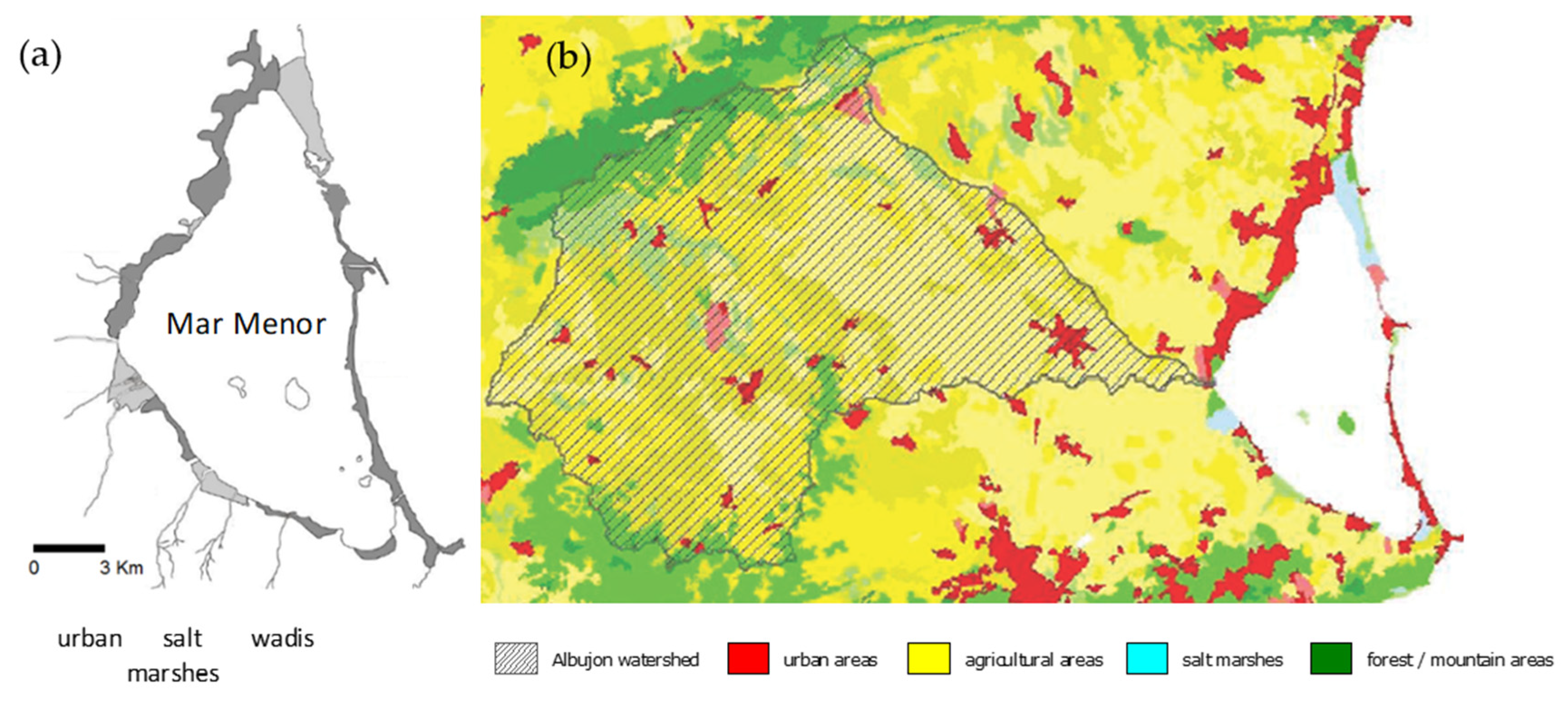
The area of study is located in the Region of Murcia, a semi-arid area in south-eastern Spain (
Figure 1). This region is distinguished by limited rainfall (<300 mm/year), which mainly occurs during storm events in autumn and winter. This watershed has been extensively transformed from a relatively traditional dryland agricultural area to one of intense human activity in the last 50 years despite having significant environmental value [
1].
Freshwater inputs into Mar Menor come mainly from six main ephemeral watercourses called ‘wadis’. These wadis can reach lengths of over 50 km. The watershed area that nourishes some of them, the Albujon, even exceeds that of the Mar Menor Lagoon itself. These wide and shallow channels are not usually active but are able to hold huge amounts of water and sediment during the usual flood periods of autumn and winter in the Mediterranean. The torrential nature of the water supply is now worsened by the impermeable soils and scarce vegetation cover of the watershed areas, going directly to the coastal lagoon. In recent decades, there has been a great transformation of the territory that has coincided with a sharp increase in the damage caused by the rains, being especially relevant those produced in the years 2016, 2018, and 2019 ([
2]).
2.2. Methodology
The framework used to analyze the impact of the phenomenon of diffuse territorial anthropization and its relationship with the increase in damage caused by floods is detailed below. A geostatistical assessment was developed to analyze the spatial correlation of the evolution of the selected indicators of territorial anthropization and the increase in damage derived from floods. This spatial statistical analysis was developed using the Local Indicators of Spatial Association (LISA). These statistical indicators evaluate the level of correlation between the behavior patterns of each of the spatial indicators of transformation of the territory generated and the distribution of the levels of damage detected in the last three DANAs. Once the numerical analysis is carried out, the level of two-dimensional correlation is analyzed from the graphic point of view through the Getis-Ord Gi* statistic indicator. We next detail the methodological process of these stages [
3].
A couple of GIS datasets were introduced in this model to develop the indices that acted as assessment parameters in the geostatistical evaluation:
- -
Georeferenced rates of the damage that happened during the three DANAs analyzed.
- -
Spatiotemporal behavior of the most relevant GIS land anthropization indices used.
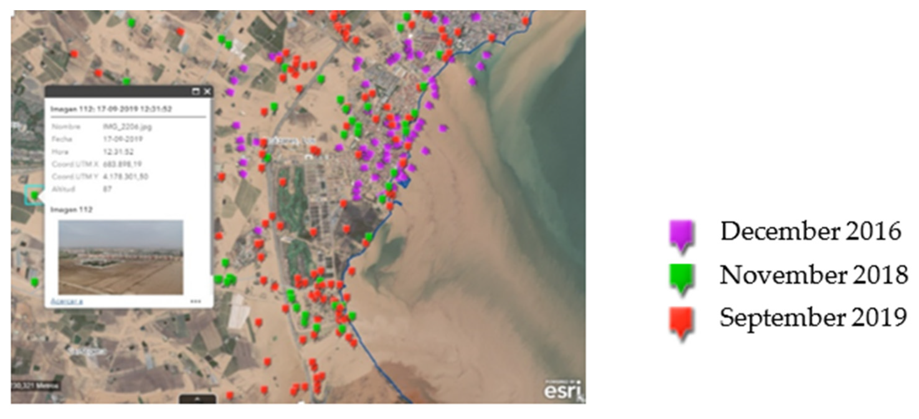
To examine the spatial distribution of damage produced by DANA, we generated an index called the Flood Damage Severity index (
). From the information provided by the emergency services from various local and regional authorities which oversee processing the damage files of those affected by the flooding events, we generated a spatial qualitative punctual database of damage (
Figure 2). These data were obtained on aggregate units such as tourist resorts, residential buildings, industrial estates, shopping centers, etc., to make georeferenced treatment possible while preserving the legal requirements of anonymity. To achieve a uniform structure of discrete values, the alphanumeric data were classified into three categories based on the level of significance of the damage following criteria, as in
Table 1: minor, relevant, and catastrophic damage.
On the other hand, the land transformation phenomena were assessed from a spatial point of view using GIS indicators of anthropization. This spatial transformation generates sub-phenomena such as the “dam effect” and “soil sealing” or alterations in the orography of the land that, according to the literature checked, may have important effects on the hazard of flooding of a territory. By using historic GIS cartographic datasets, the progress of various dimensionless indices linked with these sub-phenomena was calculated statistically over time. The indices used to evaluate the patterns of land transformation in the area of study can be found below:
Linear infrastructure density index (LID): weighted indicator of the level of territorial density of the linear communication infrastructures (these elements usually generate “dam micro-effects”).
Li = length of existing linear infrastructures (m)/hi = weighting coefficient (high-capacity motorway = 1, traditional road = 0.75, country path = 0.5)/Str = sector of the area of study (m²)
Index of soil artificialization (SA): weighted indicator of the level of artificial soil transformation associated with urbanization phenomena by applying the Corine Land Cover criteria (these processes usually generate “soil-sealing” effects) [
4].
Ai = Urbanized surface area (m2)/hi = weighting coefficient (highly artificial surface = 1, medium artificial surface = 0.75, low-waterproof artificial surface = 0.5)/Str = sector of the area of study (m2)
Index of alteration of the terrain orography (ATO): weighted indicator associated with orographic transformations or land-use changes in the territory [
5].
Ai = land-use-altered surface (m2)/hi = weighting coefficient (relevant orographic alterations = 1, medium alterations = 0.75, similar or partial land-use change = 0.5)/Str = sector of the area of study (m2)
3. Results
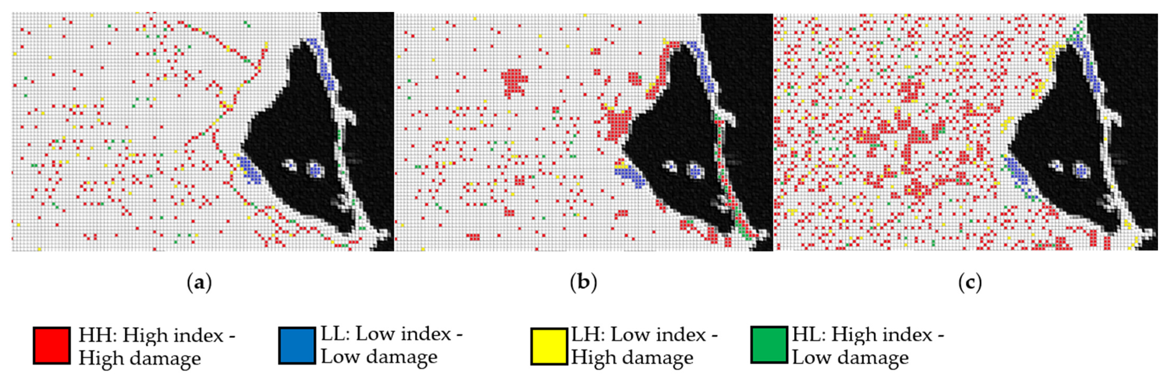
Based on the framework proposed in the methodology section, the following results were achieved. First, the existence of geostatistical significance in the distribution of the behavior patterns of the different indicators analyzed was verified. Subsequently, the levels of statistical correlation between each of the indicators of anthropic transformation and the spatial distribution of the damage detected in the last DANA were studied numerically. This evaluation was carried out considering an evolutionary approach in the 1956–2020 period to analyze the incidence of each of the indicators of territorial transformation in the global land transformation process. Then, the level of statistical correlation of each of those anthropic sub-phenomena with the intensity of damage caused by floods was assessed. To implement this analysis, the hot- and cold-spot indicators from LISA two-dimensional statistics were used.
If we parameterize the values reached to the numerical level in a bivariate Getis-Ord Gi* statistic of hot and cold spots from a spatial perspective, we can see clearly differentiated areas in the watershed, as displayed in
Figure 3.
As can be verified, diffuse territorial anthropization is a phenomenon whose effects are not easy to appreciate since it gradually accumulates over decades. However, once the impacts corresponding to this phenomenon surface, the consequences, as seen in the latest DANA in the area, can become catastrophic. In this sense, it is interesting to propose large-scale solutions that do not imply the development of aggressive infrastructures with nature to mitigate the effects of these phenomena.
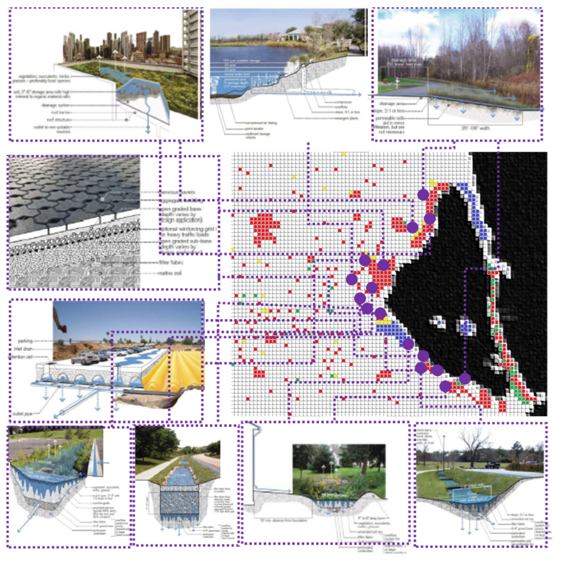
So-called nature-based solutions (NBS) are alternatives that are friendlier to the territory and whose ability to integrate into the natural environment makes them ideal alternatives to solve large-scale problems of this nature. They are tools traditionally used on an urban scale, such as the so-called sustainable urban drainage systems (SUDS). However, their combined approach by aggregating various actions on a large supra-municipal scale could be an innovative solution in this case from the point of view of integrated land management. In this context, it has been proposed, as a conceptual approach the assignment of different alternative solutions based on nature at a subregional scale as mitigation elements of the effects of this problem in the Mar Menor drainage basin. The LISA analysis of hot and cold spots carried out shows how the least-anthropized areas with the highest surface runoff retention and absorption capacity have been those that respond with the best capacity to extreme weather events.
Consequently, strategic planning is proposed at a subregional level, assigning the most appropriate alternatives to the local problems that have been observed based on the spatial statistical analysis carried out. Based on the levels of damage and the anthropic problems detected as their cause, the following NBSs have been proposed based on the results obtained for the three previously studied GIS indicators: vegetated roofs, permeable pavements, and rain gardens in urban areas, infiltration ditches, vegetated ditches, and floodable bioretention beds near linear infrastructures, and, finally, green filters, detention tanks, and retention ponds in large peri-urban areas. An initial allocation of proposals as a first approximation to this action can be seen in greater detail at a supra-municipal scale in
Figure 4.
4. Discussion and Conclusions
The work above establishes a new methodological approach which can be presented as a disruptive option in the assessment of the hazard of flooding. The analysis of the relationship between climate change, land transformation, and the increase in vulnerability to flooding is an unusual approach in the study of flood risk, which frequently tends to focus its assessment mostly on hydrological parameters rather than land-use parameters.
At the specific level, it has been possible to verify how the use of land management as a nature-based solution can be a very useful tool for mitigating this phenomenon. We have the atmospheric phenomenon of DANAs in coastal Mediterranean regions which, as highlighted by several studies [
6], are increasing in frequency and intensity because of climate change. This issue, although fitting rather to other scientific disciplines, forces us to be vigilant to this phenomenon from the point of view of land-use planning, since its effects on the local environment will also be growing.
Considering the findings achieved through the geostatistical analysis, the anthropization of the territory in the area during recent decades has had a substantial impact on the expanding risk of the Mar Menor watershed to flooding episodes. The loss of the natural hydrographic network of the basin has visibly boosted vulnerability to flooding with a distinct impact in the harm caused to people, economic activities, and highly valued ecological protected areas. Nevertheless, as in other parts of the Spanish Mediterranean façade [
7], this relationship of cause and effect does not seem to be homogeneous.


