1. Introduction
For sustainable forest management and low-cost forestry operations, appropriate road networks, including forest roads for trucks and strip roads for forwarders, must be developed in Japan. However, there are difficult conditions for promoting road network development in terms of weather, geology, topography, and soil quality [
1]. Japan belongs to the Asian monsoon zone and has a hot and rainy climate. Torrential rains occur due to the rainy season in June and the typhoon in the autumn. Geologically, it is located in the orogenic belt where the Pacific plate subducts toward the continental plate and not only has a complicated topography but also soil with unique properties derived from volcanic ejecta that is widely distributed. In addition to these conditions, road network development has not progressed sufficiently because efforts related to road network development became reluctant due to the slump in lumber prices and the fact that many forest stands have not reached the age of usefulness for planted forests. For this reason, road construction technology should be established and disseminated according to the weather conditions, geology, topography, and soil quality in Japan to improve the working environment for sustainable forest management and the forestry industry.
Iuchi et al. [
2] analyzed effect factors for the forest road disaster in southern Kyushu, Japan. As a result of analyzing the influence of various factors on the amount of collapsed soil by quantification type I, it was found that the influence is higher in the order of geology, catchment area, slope shape, vertical slope, and slope direction. Iuchi et al. [
3] also analyzed the cross-drainage ditch blockages in the Shirasu area of southern Kyushu, which contains pyroclastic flow deposits from the Aira caldera. The road networks in the Shirasu area have about three times more cross drainage ditches per 500 m than those outside the Shirasu area, but the average blockage rate was higher regardless of the number of years elapsed. In addition, the road networks in all areas were rapidly blocked by the second year after the installation of the cross-drainage ditch. After the fourth year, the average blockage rate is close to 100%, regardless of the area. As a result of factor analysis of the cross-drainage ditch blockage using quantification type I, it was found that the effect was in the order of the year after the installation, topographical gradient around the cross-drainage ditch, geology, and road surface classification. They pointed out that the maintenance period of the cross-drainage ditch is, as a guide, about 3 years after opening in the Shirasu area and about 5 years in other areas.
Muneoka et al. [
4] clarified the erosive power of forest road-surface flow depending on flow velocity. Muneoka et al. [
5] also suggested that there is no correlation between the roadside drainage area and locations that are subjected to intercepted subsurface flow and that such flow should be cared for near valleys with not only large drainage areas but also small drainage areas. Then, Muneoka et al. [
6] measured actual cross-drain spacing and compared it with an existing guideline. They indicated that appropriate cross-drain spacing can differ by dozens of meters even among segments with the same slope. Furthermore, Muneoka et al. [
7] estimated the expected value of the number of forest road collapses in a 1 km road segment caused by a rainfall event with various intensities. The estimated expected value was 10
−3 orders of magnitude with a rainfall event where the maximum rainfall per 24 hours was between 100 and 150 mm, while the value was 10
−1 orders of magnitude with a rainfall event between 300 and 350 mm. They implied that they could predict the number of forest road collapses in a given area over a certain period, taking into account the increase in density of forest roads and the frequency of intense rainfall events due to climate change.
The use of the tank model as well as the soil water index can be useful in hydrological studies and, consequently, in natural disasters, water resources management and basin management [
8,
9,
10]. Vasconcellos et al. [
11] determined the spatial behavior of the soil water index in the Araponga river basin in southern Brazil using a distributed version of the tank model and comparing it to soil moisture estimated using measured water-tension values and the water retention curve. The comparison between the spatially distributed values of the soil water index and soil moisture confirmed the high potential of the soil water index derived from the d-tank model to be applied for predictions related to hydrological and environmental sciences.
This study acquired governmental-subsidized recovery costs from forest road damages over the past 19 years, between 2001 and 2019, in Gunma Prefecture, Japan. Then, this study analyzed correlation coefficients between return periods on the soil water index as well as three-layer tank storages and recovery costs.
2. Materials and Methods
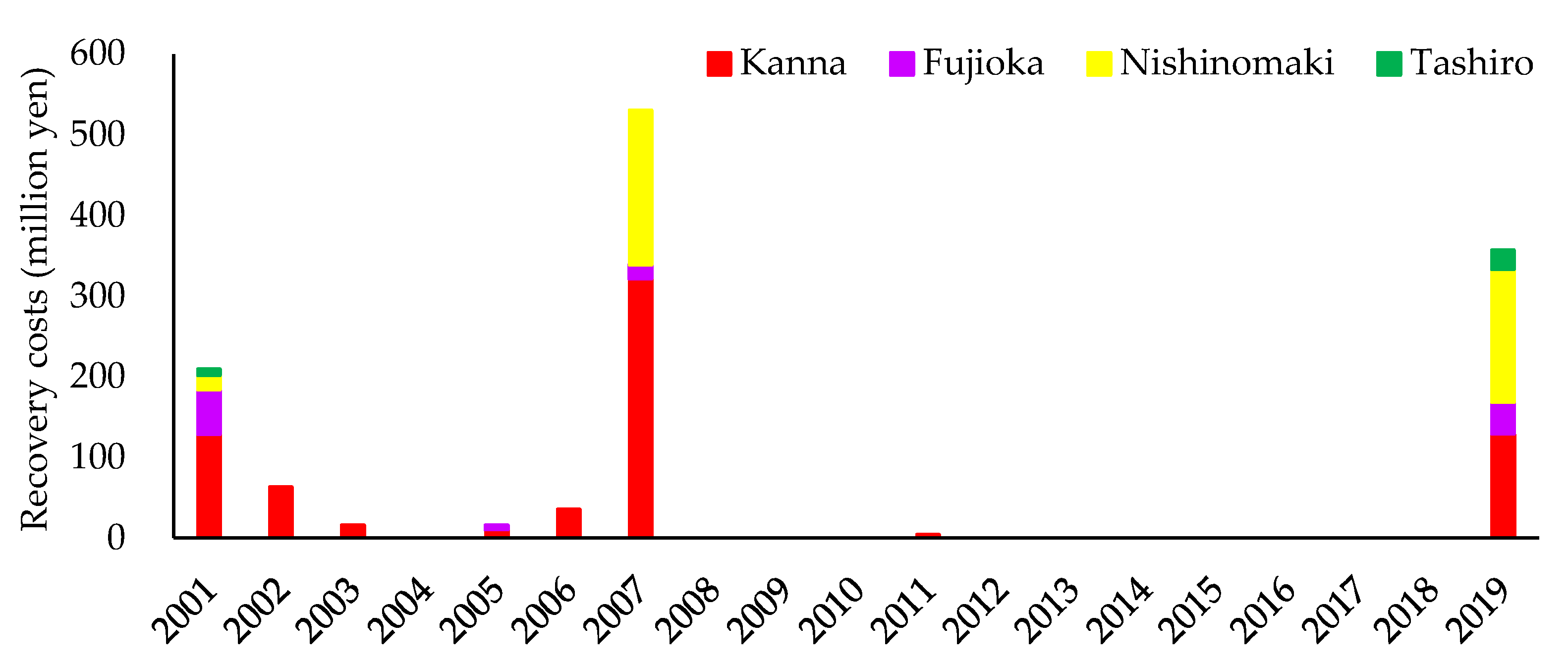
In Gunma Prefecture, relatively high governmental-subsidized recovery costs (EUR 1 = JPY 132.40 as of 24 June 2021) were incurred in 2001, 2007, and 2019 (
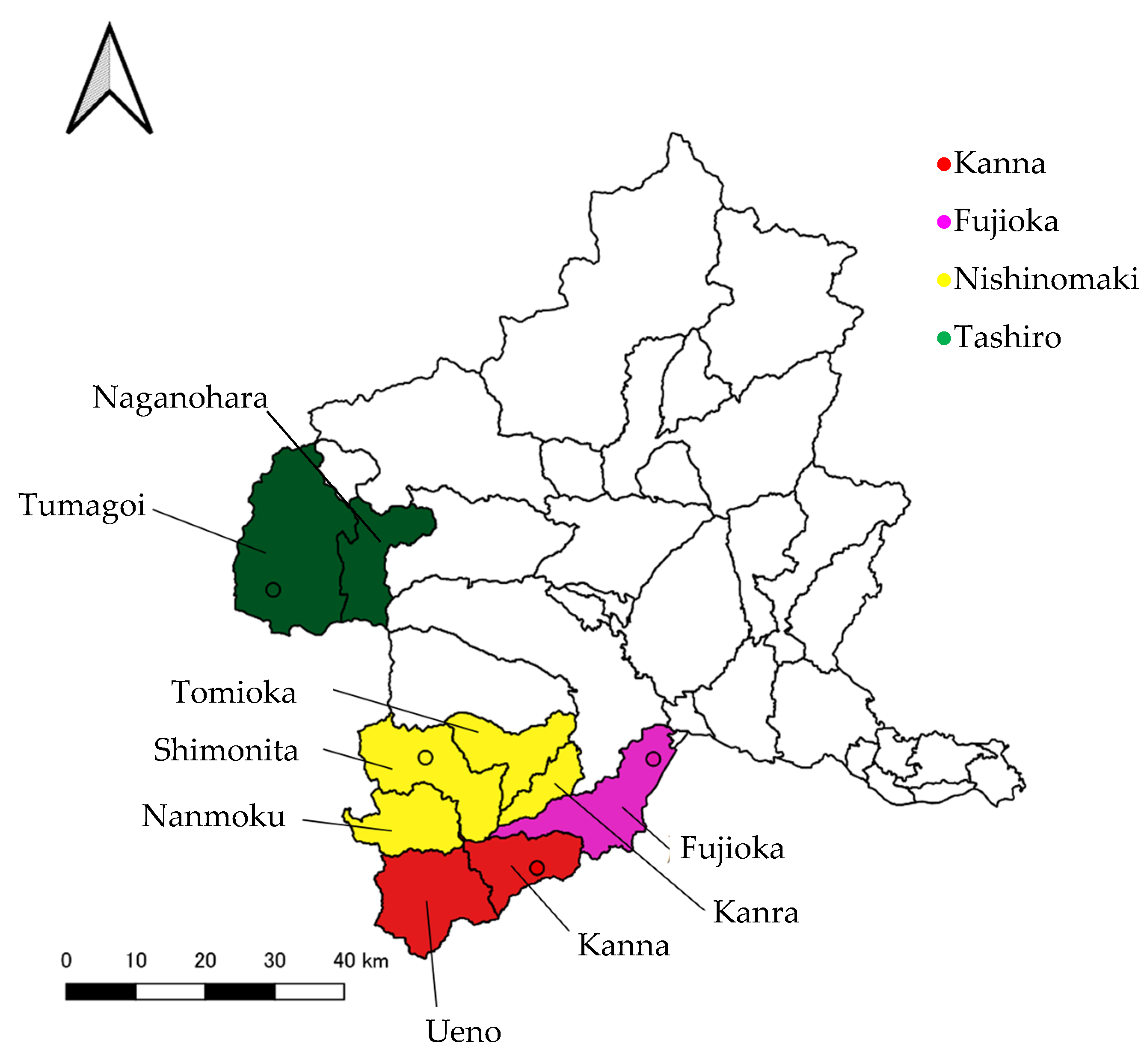
Figure 1), including the Kanna, Fujioka, Nishinomaki, and Tashiro AMeDAS stations in the prefecture’s western part (
Figure 2). Since the amounts of rainfall were heavy (
Table 1) and the governmentally subsidized recovery costs were high, this study analyzed these four stations. The Kanna AMeDAS station included Kanna town and Ueno village; the Fujioka AMeDAS station included Fujioka city; the Nishinomaki AMeDAS station included Tomioka city, Shimonita and Kanra towns, and Nammoku village; and the Tashiro AMeDAS station included Naganohara town and Tsumagoi village.
This study analyzed correlation coefficients between return periods of rainfall intensity in relation to the soil water index as well as each tank storage in an in-line 3-layer tank model with which the soil water index was calculated [
9] and recovery costs per forest road length or construction cost between 2001 and 2019.
3. Results and Discussion
The correlation coefficient between the return period of the third-layer water tank and recovery costs per forest road length was positive, with a 5% significance level for all data in these study sites (
Table 2). Although the significance was not shown, the recovery costs per forest road length tend to have a stronger positive correlation as the tank becomes deeper. Furthermore, correlation coefficients between return periods of rainfall intensity in relation to the soil water index, as well as all three-layer water tanks and recovery costs per forest road length, were positive, with 1 or 5% significance in Kanna stations, especially the third-layer water tank, which was the strongest. Therefore, the deep infiltration of rainwater from the first-layer water tank (surface runoff), the second-layer water tank (the infiltration into the surface layer), and the third-layer water tank (the infiltration into the groundwater) may have caused a large-scale disaster.
At the Fujioka AMeDAS station, there is little change in the correlation coefficient regardless of the depth of the tank. Therefore, not only rainfall but also other factors such as geology, topography, and soil quality, as well as the strength of the forest road structure, affected forest road damages. The third-layer water tank at the Nishinomaki AMeDAS station showed the highest correlation coefficient because two of the three samples had close values. The Tashiro AMeDAS station has not tested the correlation coefficient because the governmental-subsidized recovery costs were one for 2001 and one for 2019, for a total of only two samples. The Tashiro AMeDAS station was not in an area where forest road disasters occurred more frequently than at the other three AMeDAS stations during this period.
The correlation coefficients between return periods of rainfall intensity in relation to the soil water index as well as all three-layer water tanks and recovery costs per construction cost were similar to those for recovery costs per forest road length at the Kanna, Fujioka, and Nishinomaki AMeDAS stations (
Table 2). On the other hand, the correlation coefficients between the return period of rainfall intensity in relation to the soil water index as well as the first and second-layer water tanks and recovery costs per construction cost were positive with a 1% significance for all data in these study sites, although the significance of the correlation coefficient between the return period of the third-layer water tank and recovery costs per construction cost was not shown (
Table 2). This would be due to including only construction costs and not pavement and improvement costs during maintenance, which strengthened the forest road structure.
4. Conclusions
This study acquired governmental-subsidized recovery costs from forest road damages over the past 19 years, between 2001 and 2019, in Gunma Prefecture. Then, this study analyzed correlation coefficients between return periods of rainfall intensity in relation to the soil water index as well as three-layer water tanks and recovery costs. As a result, large forest road damages were implied as a result of deep rainwater penetration because correlation coefficients between water tanks and recovery costs per forest road length tended to increase with deeper tanks. Although the study sites were four AMeDAS stations, such as Kanna, Fujioka, Nishinomaki, and Tashiro, which had relatively large governmental-subsidized recovery costs in 2001, 2007, and 2019, located in the western part of the prefecture, future studies will include other parts of the prefecture as well as other prefectures to extend analyses with more data if available.


