1. Introduction
Up to 1% of the forested area is exposed to wildfires annually in Siberia [
1,
2], which accounts for a significant proportion of post-fire damage to the boreal forests of the world [
3,
4]. Considering the climate changes, a further increase in burned areas in Siberia is predicted [
5,
6,
7,
8]. In addition to the direct post-fire tree stands mortality [
9,
10], environmental consequences in post-fire plots have been manifest for decades [
11,
12,
13].
Spectral indices based on satellite information allow quantitative assessment of the degree of pyrogenic disturbance of forests [
14]. These data are very important characteristics of the forest state on the scale of Siberia. One such index is the Normalized Burn Ratio (NBR) and its pre- versus post-fire difference (dNBR) [
15,
16]. The dNBR characterizes the degree of forest damage depending on the type of wildfire and the intensity of burning [
17]. Preliminary classification of the fire impact within a post-fire plot [
16] allows for remote controlling and predicting the rate and success of vegetation recovery processes. As a rule, the vegetation index is widely used, which was proposed by Rouse et al. in 1973 [
18,
19]. The Normalized Difference Vegetation Index (NDVI) is the most well-known vegetation index [
20].
Post-fire damage and vegetation restoration can also be inspected in terms of reducing the surface reflectivity (albedo) and changing the thermal-insulating properties of the soil and vegetation cover, while post-fire plots are characterized by long-term surface thermal anomalies compared to the temperature of non-disturbed areas [
13,
21]. Such techniques of quantitative control of post-fire plots are effective for up to 20–40 years, depending on the initial fire impact [
22].
Although post-fire tree stands mortality in Siberia is discussed widely [
9,
10,
16], the issue of remote assessment of recovery processes (taking into account the characteristics of dominant tree stands of Siberia) remains not fully studied. Thus, the main aim of this study was to estimate the relation between the degree of fire impact and the dynamics of restoration processes, based on remote spectral indices and on data for dominant tree stands of Siberia.
We investigated the following issues: (a) the variation of the NBR/dNBR index on a series of post-fire sites in relation to the dominant tree stands; (b) the 5-year dynamics of surface temperature anomalies and the NDVI anomalies relative to background values which were restored to characterize post-fire restoration for various variants of the vegetation cover of Siberia.
2. Material and Methods
For the research, we used satellite data for Siberia (50–75° N, 60–150° E). Landsat–8/OLI/TIRS (Operational Ground Thermal Imager/Thermal Infrared Sensor) images of moderate spatial resolution were obtained from United States Geological Survey (USGS) free-access database (
https://earthexplorer.usgs.gov/, accessed on 25 August 2022). The spatial resolution of the survey is 30 m for OLI data, and 100 m for TIRS data. A 5-year time series of satellite data (42 images in total) was processed for eight post-fire plots (total area of 218 thousand hectares) in four variants of the dominant tree stands: Larch (
Larix sibirica) and Scots pine (
Pinus sylvestris) (light coniferous stands), as well as Spruce (
Abies sibirica) and Fir (
Picea obovata) (dark coniferous stands). Vegetation cover was controlled based on the materials of the “Vega-service” (Database of the Institute of Space Research of the Russian Academy of Sciences, IKI RAS, Moscow,
http://pro-vega.ru/maps/, accessed 27 July 2022) [
23].
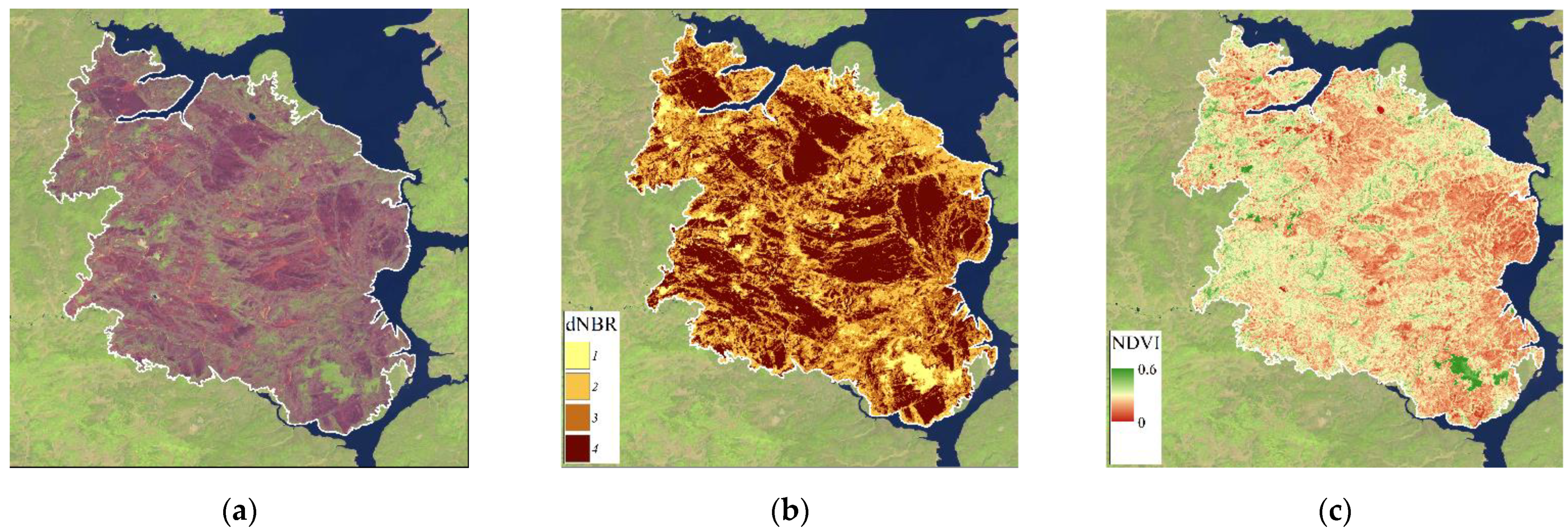
Firstly, we classified fire polygons based on the NBR/dNBR ranges to differentiate the initial fire impact. We used the QGIS program and the Semi-Automatic Classification Plugin (Quantum Geographic Information System, version 3.16.3,
https://www.qgis.org, accessed on 25 August 2022) to evaluate the NBR/dNBR using standard approaches [
15,
17,
20]. The threshold method was used to identify four classes (undamaged vegetation, low, moderate, and high fire impact) of initial damage to the vegetation cover, corresponding to the dNBR ranges (
Table 1) [
15,
20,
24].
Next, the long-term series of the NDVI and surface temperature was restored from >160 satellite images over a 5-year period after exposure to fire. We used data from the thermal channel B10 (TIR, λ = 10.30–11.30 µm) to calculate the brightness temperature of the surface. Preliminary atmospheric correction was performed for the initial standard product “Landsat Collection 1 Level 1”. Data from channels B4 (RED, λ = 0.63–0.68 µm) and B5 (NIR, λ = 0.85–0.89 µm) were used to calculate the NDVI.
Surface temperature data were averaged over the growing season for each post-fire plot. Temperature anomalies (ΔT/T
bg, %) were calculated as the ratio of the average values within the post-fire plot (ΔT) and background values (T
bg) of the non-disturbed area. Similarly, relative NDVI anomalies were determined (ΔNDVI/NDVI
bg, %). At least 20 measurements were carried out for each post-fire plot (
Figure 1). Averaging over the vegetation season was performed by 3–6 values per month.
Finally, we analyzed the 5-year post-fire trends of ΔT/Tbg and ΔNDVI/NDVIbg anomalies for each variant of the dominant tree stand. Trends were considered separately for low, medium, and high degrees of initial fire impact.
3. Results and Discussion
3.1. Fire Impact Ratio in Dominant Tree Stands
We evaluated the ratio of areas with different levels of post-fire impact in terms of dNBR (
Table 2). In general, the proportions of low, moderate, and high fire severity were 37%, 39%, and 24% of the total area burned, respectively, in dense tree stands. The proportions varied to 30%, 57%, and 13%, respectively, for sparse stands and tundra vegetation dominant in the north of Siberia.
Fires in Siberian Larch forests annually account for up to 65% of the total area of burnt forests [
1]. In larch forests, up to 80% of the total area of post-fire sites is attributed to moderate (>45% of the total area) and high levels (33%) of fire impact. Fires in pine forests on average account for up to 18% of the total area burned annually. Post-fire plots in Pine stands were attributed to low (~50%) and medium (36%) fire impact. A high level of post-fire damage was recorded only in 12.6% of territories (SD = 13.5 for α = 0.05). The ratio of wildfires in the dark coniferous stands (
Abies sibirica,
Picea obovata) of Siberia is about 5.6% [
1]. In this regard, we were able to consider a limited number of fires in these stands. We summarized the statistics for wildfires in Spruce and Fir in
Table 2. The area of fires were 39%, 34%, and 26% for low, medium, and high fire severity/initial impact, respectively. Significant SD was evaluated for high severity (SD = 20.1 for α = 0.05). These results correspond to the previously obtained data for a larger sample of fires in Siberia [
16].
3.2. Long-Term Temperature Anomalies
The fire impact reduces the reflectivity of the surface (albedo). The heat-insulating properties of the soil and vegetation cover are also changing. It was previously shown that long-term anomalies of the surface thermal regime in relation to the background are typical for post-fire areas [
13,
21,
22].
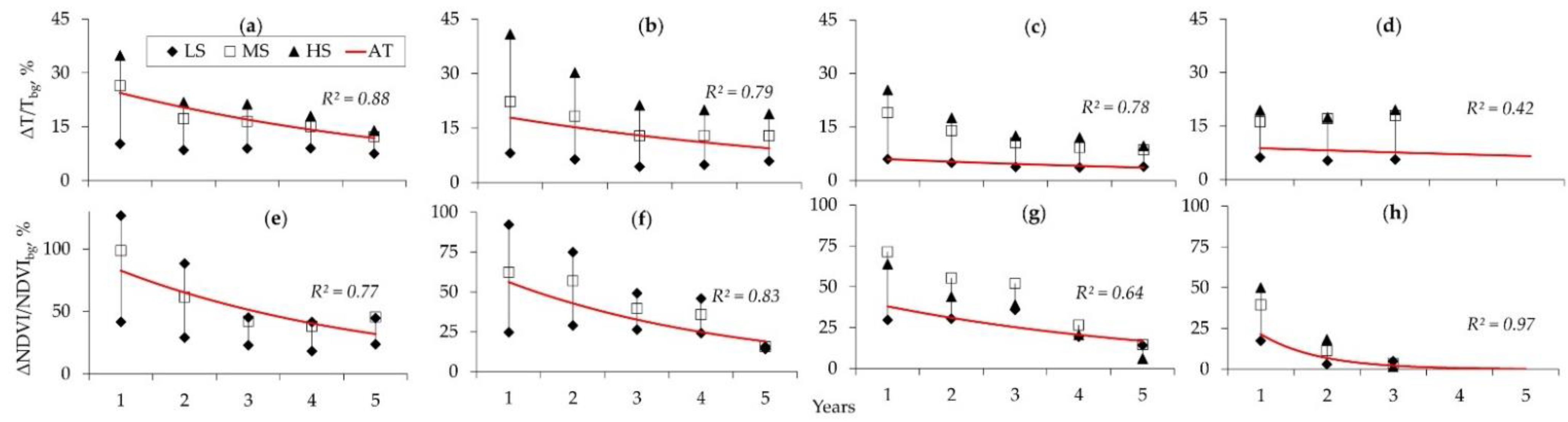
We found that the values of temperature anomalies (ΔT/T
bg, %) are determined by the initial level of fire impact and by the type of tree stand (
Figure 2a–d). Within 5 years after the fire, an exponential decrease in temperature anomalies is observed. The highest level of initial thermal anomaly in the first year after the fire is observed in Pine plantations (exceeding by 45% relative to the background) under the conditions of high initial fire impact in terms of dNBR (
Figure 2a). The initial level of ΔT/T
bg was ~35% for post-fire plots in Larch forests, and was 25% and 20%, respectively, for plots of Spruce and Fir.
The values of ΔT/T
bg are stabilized over a 5-year period. An exponential trend (R
2 = 0.42–0.88) describes the rate of decrease of the temperature anomaly for all variants of the initial fire severity (
Figure 2. AT), although the residual ΔT/T
bg still remains significantly high (~15%) in post-fire plots with a predominance of light conifers (Pine, Larch). In dark conifers stands, the residual ΔT/T
bg (~5–7%) are twice as low as in light conifers. At the same time, the rate of the recovery process (in terms of thermal anomalies) is significantly lower than in light coniferous forests (
Figure 2, AT for a, b versus c, d).
3.3. NDVI Anomalies
A relatively high recovery rate was recorded for the ΔNDVI/NDVI
bg anomalies during the first 3 years after fire impact. Furthermore, the values are stabilized at a level of at least 5–15% understatement of the background, depending on the dominant tree stands (
Figure 2e–h). We found high level of ΔNDVI/NDVI
bg anomaly (~40–45%) in Larch forests after 5 years of post-fire recovery, because of significant disturbance of the ground cover [
25]. Such consequences can stay significant, as a rule, no more than 7–10 years after fire impact [
12]. For other considered tree stands, the level of residual ΔNDVI/NDVI
bg anomaly does not exceed 5–15% of the background values after 5 years of restoration. Such ranges may be statistically insignificant for further assessment of recovery processes (5 years or more) according to satellite vegetation indices.
An exponential trend (R
2 = 0.64–0.97) describes the rate of decrease of ΔNDVI/NDVI
bg anomaly for all variants of the initial fire severity (
Figure 2. AT).
4. Conclusions
Spectral indices allow us to estimate both the degree of fire impact on tree stands and the rate of recovery processes in terms of ΔT/Tbg and ΔNDVI/NDVIbg.
We quantified the proportions of low (37%), moderate (39%), and high (24%) fire severity in dense tree stands. The proportions were varied to 30%, 57%, and 13%, respectively, for sparse stands and tundra vegetation dominant in the north of Siberia.
We evaluated the most significant level of ΔT/Tbg anomaly in Pine stands (~40%), next in Larch stands (~35%), and in dark coniferous spruce (~25%) and fir (~20%) forests. An exponential decrease in temperature anomalies is observed within 5 years after the fire impact. A high recovery rate was recorded for the ΔNDVI/NDVIbg anomalies during the first 3 years after fire impact, and finally the values stabilized at 5–15% understatement of the background.
Thus, for effective satellite monitoring of recovery process, it is necessary to consider both the initial level of fire damage and the differences caused by the dominant tree stands of Siberia. This is the least costly and most effective approach for Siberia, despite all the limitations.
Author Contributions
Conceptualization, E.I.P.; methodology, E.I.P.; software, E.I.P., N.D.Y.; validation, E.I.P., N.D.Y. and A.N.Z.; formal analysis, E.I.P.; investigation, E.I.P., N.D.Y. and A.N.Z.; resources, E.I.P., N.D.Y.; data curation, E.I.P.; writing—original draft preparation, E.I.P., N.D.Y. and A.N.Z.; writing—review and editing, E.I.P.; visualization, N.D.Y., A.N.Z.; supervision, E.I.P.; project administration, E.I.P.; funding acquisition, E.I.P. All authors have read and agreed to the published version of the manuscript.
Funding
This study was performed using the subject of project no. 0287-2021-0008 (IF SB RAS) and no. 0287-2021-0040 (KSC SB RAS). The study was supported by the Tomsk State University Development Programme («Priority-2030»).
Institutional Review Board Statement
Not applicable.
Informed Consent Statement
Not applicable.
Data Availability Statement
Acknowledgments
The satellite data-receiving equipment used was provided by the Center of Collective Usage of Federal Research Center “Krasnoyarsk Science Center, Siberian Branch of Russian Academy of Sciences”, Krasnoyarsk, Russia.
Conflicts of Interest
The authors declare no conflict of interest.
References
- Kharuk, V.I.; Ponomarev, E.I.; Ivanova, G.A.; Dvinskaya, M.L.; Coogan, S.C.P.; Flannigan, M.D. Wildfires in the Siberian taiga. Ambio 2021, 50, 1953–1974. [Google Scholar] [CrossRef] [PubMed]
- Ponomarev, E.I.; Skorobogatova, A.S.; Ponomareva, T.V. Wildfire Occurrence in Siberia and Seasonal Variations in Heat and Moisture Supply. Russ. Meteorol. Hydrol. 2018, 43, 456–463. [Google Scholar] [CrossRef]
- Flannigan, M.; Stocks, B.; Turetsky, M.; Wotton, M. Impacts of climate change on fire activity and fire management in the circumboreal forest. Glob. Chang. Biol. 2009, 15, 549–560. [Google Scholar] [CrossRef]
- McCarty, J.L.; Aalto, J.; Paunu, V.V.; Arnold, S.R.; Eckhardt, S.; Klimont, Z.; Fain, J.J.; Evangeliou, N.; Venäläinen, A.; Tchebakova, N.M.; et al. Reviews and syntheses: Arctic fire regimes and emissions in the 21st century. Biogeosciences 2021, 18, 5053–5083. [Google Scholar] [CrossRef]
- Leskinen, P.; Lindner, M.; Verkerk, P.J.; Nabuurs, G.J.; Van Brusselen, J.; Kulikova, E.; Hassegawa, M.; Lerink, B. (Eds.) Russian Forests and Climate Change. What Science Can Tell Us 11. 2020. Available online: https://efi.int/sites/default/files/files/publication-bank/2020/efi_wsctu_11_2020.pdf (accessed on 28 July 2022). [CrossRef]
- Zhang, Z.; Wang, L.; Xue, N.; Du, Z. Spatiotemporal Analysis of Active Fires in the Arctic Region during 2001–2019 and a Fire Risk Assessment Model. Fire 2021, 4, 57. [Google Scholar] [CrossRef]
- Ponomarev, E.; Yakimov, N.; Ponomareva, T.; Yakubailik, O.; Conard, S.G. Current Trend of Carbon Emissions from Wildfires in Siberia. Atmosphere 2021, 12, 559. [Google Scholar] [CrossRef]
- Hayasaka, H. Fire Weather Conditions in Boreal and Polar Regions in 2002–2021. Atmosphere 2022, 13, 1117. [Google Scholar] [CrossRef]
- Bartalev, S.A.; Stytsenko, F.V. Assessment of Forest Stands Destruction by Fires Based on Remote Sensing Data on the Seasonal Distribution of Burned Areas. Contemp. Probl. Ecol. 2021, 14, 711–716. [Google Scholar] [CrossRef]
- Loupian, E.A.; Lozin, D.V.; Balashov, I.V.; Bartalev, S.A.; Stytsenko, F.V. Study of the dependence of forest fire damage degree on burning intensity based on satellite monitoring data. Mod. Probl. Remote Sens. Earth Space 2022, 19, 217–232. (In Russian) [Google Scholar] [CrossRef]
- Kirdyanov, A.V.; Saurer, M.; Siegwolf, R.T.W.; Knorre, A.A.; Prokushkin, A.S.; Churakova, O.V.; Fonti, M.V.; Büntgen, U. Long-term ecological consequences of forest fires in the continuous permafrost zone of Siberia. Environ. Res. Lett. 2020, 15, 034061. [Google Scholar] [CrossRef]
- Ponomarev, E.I.; Masyagina, O.V.; Litvintsev, K.Y.; Ponomareva, T.V.; Shvetsov, E.G.; Finnikov, K.A. The effect of post-fire disturbances on a seasonally thawed layer in the permafrost larch forests of Central Siberia. Forests 2020, 11, 790. [Google Scholar] [CrossRef]
- Yakimov, N.D.; Ponomarev, E.I.; Ponomareva, T.V. Satellite monitoring of the state and dynamics of disturbed natural and technogenic landscapes in Siberia. CEUR Workshop Proc. 2021, 3006, 585–593. [Google Scholar] [CrossRef]
- Krylov, A.; McCarty, J.L.; Potapov, P.; Loboda, T.; Tyukavina, A.; Turubanova, S.; Hansen, M.C. Remote sensing estimates of stand-replacement fires in Russia, 2002–2011. Environ. Res. Lett. 2014, 9, 1–8. [Google Scholar] [CrossRef]
- Dos Santos, S.M.B.; Bento-Gonçalves, A.; Franca-Rocha, W.; Baptista, G. Assessment of Burned Forest Area Severity and Postfire Regrowth in Chapada Diamantina National Park (Bahia, Brazil) Using dNBR and RdNBR Spectral Indices. Geosciences 2020, 10, 106. [Google Scholar] [CrossRef]
- Ponomarev, E.I.; Zabrodin, A.N.; Ponomareva, T.V. Classification of Fire Damage to Boreal Forests of Siberia in 2021 Based on the dNBR Index. Fire 2022, 5, 19. [Google Scholar] [CrossRef]
- Chu, T.; Guo, X.; Takeda, K. Temporal dependence of burn severity assessment in Siberian larch (larix sibirica) forest of northern Mongolia using remotely sensed data. Int. J. Wildland Fire 2016, 25, 685–698. [Google Scholar] [CrossRef]
- Rouse, J.W., Jr.; Haas, R.H.; Schell, J.A.; Deering, D.W. Monitoring the Vernal Advancement and Retrogradation (Green Wave Effect) of Natural Vegetation; Progress Reports RSC 1978-1 93; Texas A & M University: College Station, TX, USA, 1973. [Google Scholar]
- Tucker, C.J. Red and Photographic Infrared Linear Combinations Monitoring Vegetation. J. Remote Sens. Environ. 1979, 8, 127–150. [Google Scholar] [CrossRef]
- Delcourt, C.J.F.; Combee, A.; Izbicki, B.; Mack, M.C.; Maximov, T.; Petrov, R.; Rogers, B.M.; Scholten, R.C.; Shestakova, T.A.; van Wees, D.; et al. Evaluating the Differenced Normalized Burn Ratio for Assessing Fire Severity Using Sentinel-2 Imagery in Northeast Siberian Larch Forests. Remote Sens 2021, 13, 2311. [Google Scholar] [CrossRef]
- Ponomarev, E.I.; Ponomareva, T.V. The Effect of Postfire Temperature Anomalies on Seasonal Soil Thawing in the Permafrost Zone of Central Siberia Evaluated Using Remote Data. Contemp. Probl. Ecol. 2018, 11, 420–427. [Google Scholar] [CrossRef]
- Ponomareva, T.V.; Litvintsev, K.Y.; Finnikov, K.A.; Yakimov, N.D.; Sentyabov, A.V.; Ponomarev, E.I. Soil Temperature in Disturbed Ecosystems of Central Siberia: Remote Sensing Data and Numerical Simulation. Forests 2021, 12, 994. [Google Scholar] [CrossRef]
- Loupian, E.A.; Bourtsev, M.A.; Proshin, A.A.; Kashnitskiy, A.V.; Balashov, I.V.; Bartalev, S.A.; Konstantinova, A.M.; Kobets, D.A.; Radchenko, M.V.; Tolpin, V.A.; et al. Usage Experience and Capabilities of the VEGA-Science System. Remote Sens. 2022, 14, 77. [Google Scholar] [CrossRef]
- Key, C.H.; Benson, N.C. Landscape Assessment: Sampling and Analysis Methods. In FIREMON: Fire Effects Monitoring and Inventory System; USDA Forest Service Gen. Tech. Rep. RMRS-GTR-164-CD; 2006. Available online: https://www.fs.usda.gov/treesearch/pubs/24066 (accessed on 27 July 2022).
- Shvetsov, E.G.; Ponomarev, E.I. Postfire Effects in Siberian Larch Stands on Multispectral Satellite Data. Contemp. Probl. Ecol. 2020, 1, 104–112. [Google Scholar] [CrossRef]
| Disclaimer/Publisher’s Note: The statements, opinions and data contained in all publications are solely those of the individual author(s) and contributor(s) and not of MDPI and/or the editor(s). MDPI and/or the editor(s) disclaim responsibility for any injury to people or property resulting from any ideas, methods, instructions or products referred to in the content. |
© 2022 by the authors. Licensee MDPI, Basel, Switzerland. This article is an open access article distributed under the terms and conditions of the Creative Commons Attribution (CC BY) license (https://creativecommons.org/licenses/by/4.0/).


