
Climatological Variations in the Intensity of Tropical Cyclones Formed over the North Atlantic Basin Using the Hurricane Maximum Potential Intensity (HuMPI) Model †


Abstract
:1. Introduction
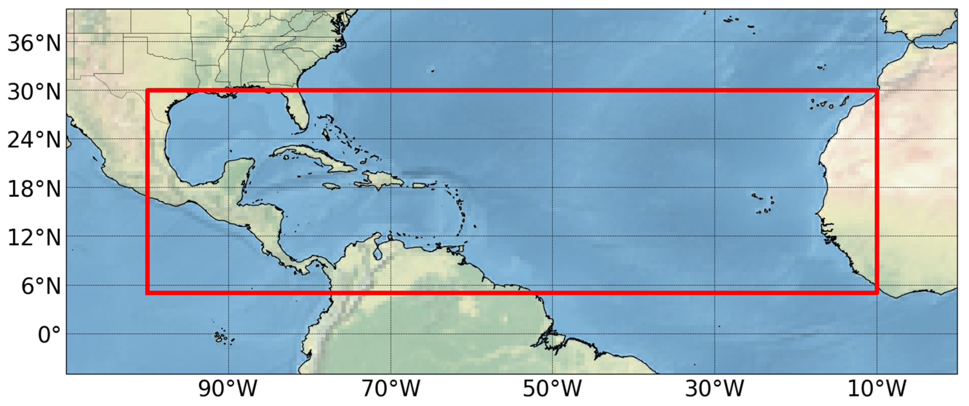
2. Data and Methods
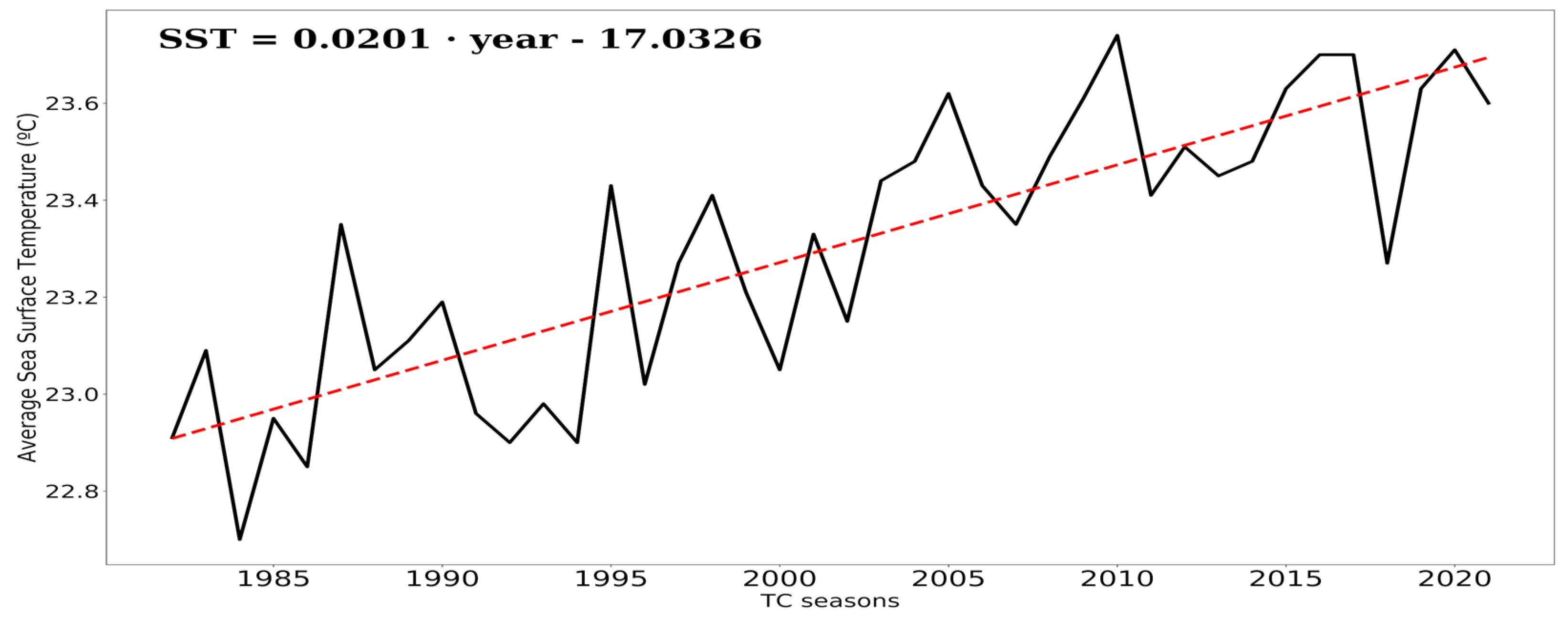
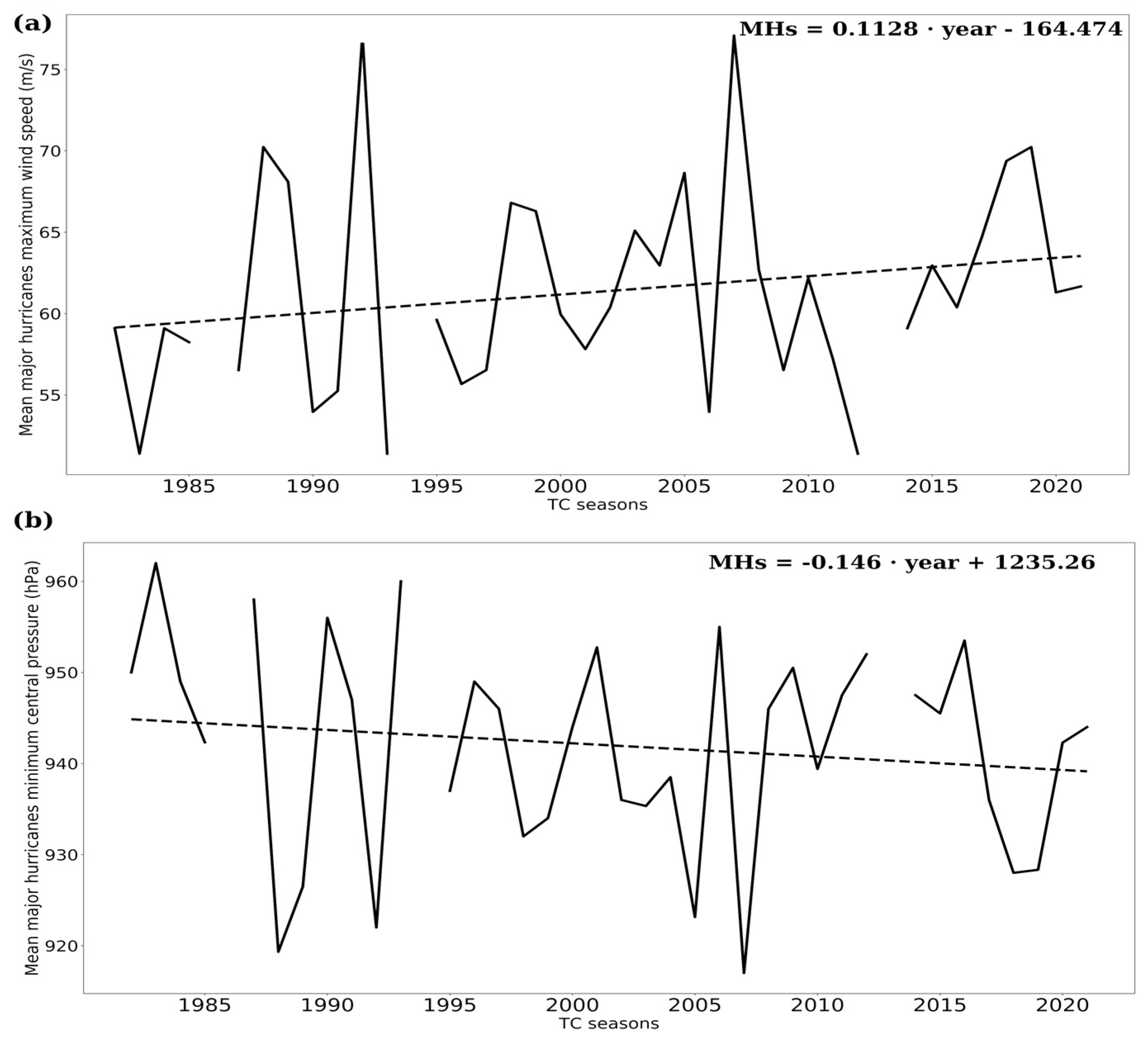
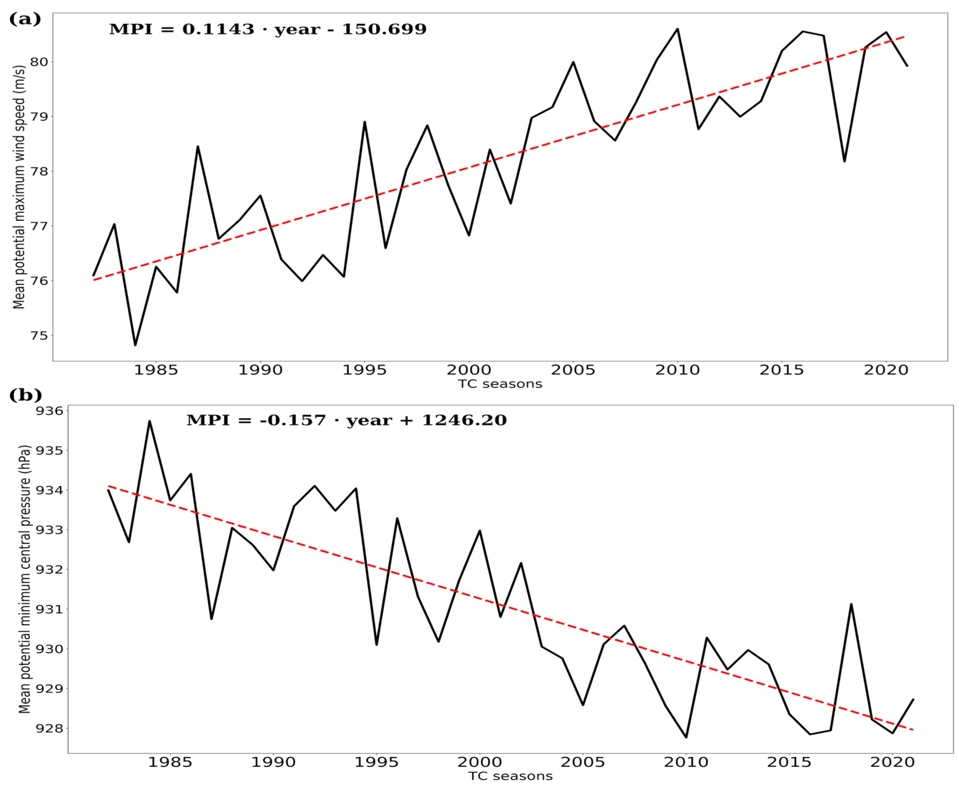
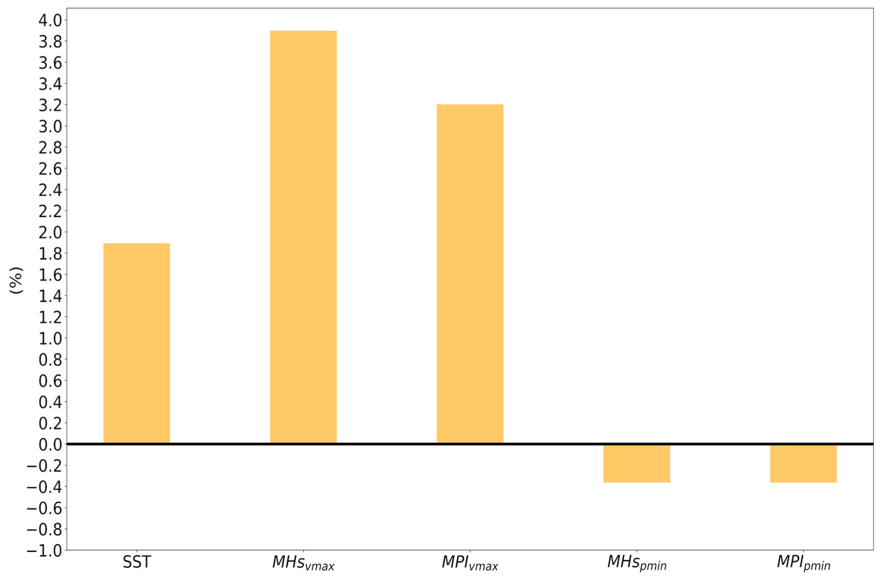
3. Results and Discussion
4. Conclusions
Author Contributions
Funding
Institutional Review Board Statement
Informed Consent Statement
Data Availability Statement
Acknowledgments
Conflicts of Interest
References
- Guha-Sapir, D.; Below, R.; Hoyois, P. EM-DAT: International Disaster Database; Université Catholique de Louvain: Brussels, Belgium, 2013; Available online: https://www.emdat.be/ (accessed on 5 April 2022).
- Peduzzi, P.; Chatenoux, B.; Dao, H.; De Bono, A.; Herold, C.; Kossin, J.; Mouton, F.; Nordbeck, O. Global trends in tropical cyclone risk. Nat. Clim. Chang. 2012, 2, 289–294. [Google Scholar] [CrossRef]
- Klotzbach, P.J.; Bowen, S.G.; Pielke, R., Jr.; Bell, M.M. Continental United States landfall frequency and associated damage: Observations and future risks. Bull. Am. Meteorol. Soc. 2018, 99, 13591376. [Google Scholar] [CrossRef]
- Mendelsohn, R.; Emanuel, K.; Chonabayashi, S.; Bakkensen, L. The impact of climate change on global tropical cyclone damage. Nat. Clim. Chang. 2012, 2, 205–209. [Google Scholar] [CrossRef]
- Petrova, L.I. Estimating the maximum potential intensity of tropical cyclones. Russ. Meteorol. Hydrol. 2010, 35, 371–377. [Google Scholar] [CrossRef]
- Knapp, K.R.; Kruk, M.C.; Levinson, D.H.; Diamond, H.J.; Neumann, C.J. The international best track archive for climate stewardship (IBTrACS): Unifying tropical cyclone data. Bull. Am. Meteorol. Soc. 2010, 91, 363–376. [Google Scholar] [CrossRef]
- Emanuel, K. Atlantic tropical cyclones downscaled from climate reanalyses show increasing activity over past 150 years. Nat. Commun. 2021, 12, 7027. [Google Scholar] [CrossRef] [PubMed]
- Webster, P.J.; Holland, G.J.; Curry, J.A.; Chang, H.-R. Changes in tropical cyclone number, duration and intensity in a warming environment. Nature 2005, 309, 1844–1846. [Google Scholar] [CrossRef] [PubMed]
- Klotzbach, P.J.; Landsea, C.W. Extremely intense hurricanes: Revisiting Webster et al. (2005) after 10 years. J. Clim. 2015, 28, 7621–7629. [Google Scholar] [CrossRef]
- Kossin, J.P.; Knapp, K.R.; Olander, T.L.; Velden, C.S. Global increases in major tropical cyclone exceedance probability over the past four decades. Proc. Natl. Acad. Sci. USA 2020, 117, 11975–11980. [Google Scholar] [CrossRef] [PubMed]
- Pérez-Alarcón, A.; Fernández-Alvarez, J.C.; Sorí, R.; Nieto, R.; Gimeno, L. The relationship of the sea surface temperature and climate variability modes with the North Atlantic tropical cyclones activity. Rev. Cub. Met. 2021, 27, 1–15. Available online: https://rcm.insmet.cu/index.php/rcm/article/view/575/1163 (accessed on 5 April 2022).
- Klotzbach, P.J.; Wood, K.M.; Schreck, C.J.; Bowen, S.G.; Patricola, C.M.; Bell, M.M. Trends in global tropical cyclone activity: 1990–2021. Geophys. Res. Lett. 2022, 49, e2021GL095774. [Google Scholar] [CrossRef]
- Pérez-Alarcón, A.; Fernández-Alvarez, J.C.; Díaz-Rodríguez, O. Hurricane Maximum Potential Intensity Model. Rev. Cub. Fís. 2021, 38, 85–93. Available online: https://www.revistacubanadefisica.org/index.php/rcf/article/view/2021v38p085 (accessed on 5 April 2022).
- Landsea, C.W.; Franklin, J.L. Atlantic hurricane database uncertainty and presentation of a new database format. Mon. Wea. Rev. 2013, 141, 3576–3592. [Google Scholar] [CrossRef]
- Pérez-Alarcón, A.; Fernández-Alvarez, J.C.; Díaz-Rodríguez, O. HuMPI: Hurricane Maximum Potential Intensity Model (V1.0); Zenodo: Geneva, Switzerland, 2022. [Google Scholar] [CrossRef]
- Banzon, V.; Smith, T.; Steele, M.; Huang, B.; Zhang, H.-M. Improved estimation of proxy sea surface temperature in the Arctic. J. Atmos. Ocean. Technol. 2020, 37, 341–349. [Google Scholar] [CrossRef]
- Taboada, F.G.; Anadón, R. Patterns of change in sea surface temperature in the North Atlantic during the last three decades: Beyond mean trends. Clim. Chang. 2012, 115, 419–431. [Google Scholar] [CrossRef]


Publisher’s Note: MDPI stays neutral with regard to jurisdictional claims in published maps and institutional affiliations. |
© 2022 by the authors. Licensee MDPI, Basel, Switzerland. This article is an open access article distributed under the terms and conditions of the Creative Commons Attribution (CC BY) license (https://creativecommons.org/licenses/by/4.0/).
Share and Cite
Pérez-Alarcón, A.; Fernández-Alvarez, J.C. Climatological Variations in the Intensity of Tropical Cyclones Formed over the North Atlantic Basin Using the Hurricane Maximum Potential Intensity (HuMPI) Model. Environ. Sci. Proc. 2022, 19, 34. https://doi.org/10.3390/ecas2022-12828
Pérez-Alarcón A, Fernández-Alvarez JC. Climatological Variations in the Intensity of Tropical Cyclones Formed over the North Atlantic Basin Using the Hurricane Maximum Potential Intensity (HuMPI) Model. Environmental Sciences Proceedings. 2022; 19(1):34. https://doi.org/10.3390/ecas2022-12828
Chicago/Turabian StylePérez-Alarcón, Albenis, and José C. Fernández-Alvarez. 2022. "Climatological Variations in the Intensity of Tropical Cyclones Formed over the North Atlantic Basin Using the Hurricane Maximum Potential Intensity (HuMPI) Model" Environmental Sciences Proceedings 19, no. 1: 34. https://doi.org/10.3390/ecas2022-12828