Proceeding Paper

Impact of the Assimilation of Non-Precipitating Echoes Reflectivity Data on the Short-Term Numerical Forecast of SisPI †

by
Adrian Luis Ferrer Hernández
*,
Pedro Manuel González Jardines
,
Maibys Sierra Lorenzo
and
Darielis de la Caridad Aguiar Figueroa
Center for Atmospheric Physics, Institute of Meteorology, La Habana 11700, Cuba
*
Author to whom correspondence should be addressed.
Presented at the 5th International Electronic Conference on Atmospheric Sciences, 16–31 July 2022; Available online: https://ecas2022.sciforum.net/.
Environ. Sci. Proc. 2022, 19(1), 13; https://doi.org/10.3390/ecas2022-12845
Published: 25 July 2022
(This article belongs to the Proceedings of The 5th International Electronic Conference on Atmospheric Sciences)

Abstract

:
The research carried out an evaluation of the 3DVAR method with different options for the assimilation of reflectivity data, which were applied to the SisPI system with the purpose of determining which scheme presents the best results in the short-term numerical weather prediction. For this, data from six meteorological radars with coverage over a domain with 3 km of spatial resolution were used, utilizing the indirect method with (3DVAR-NoRain) and without (3DVAR) activating an option to also consider null echoes of reflectivity without the presence of precipitation. As a test case, the cold front that affected Cuba on 10 December 2018 was taken.

1. Introduction

The short-term numerical weather prediction system (SisPI for its acronym in Spanish) [1,2,3] is one of the operational models that are implemented in the Institute of Meteorology of Cuba (INSMET). The SisPI uses the Weather Research & Forecast (WRF) [4] model as the atmospheric core. The design of this system [1] takes into account the development of a module for data assimilation of different types of meteorological observations. For this reason, this work approached the weather forecasts from the point of view of the data assimilation, explaining how the insertion of a new data source such as meteorological radars can improve the initial conditions and subsequently the result of the simulation.
The first steps in the assimilation of radar data in Cuba were through the work of [5] and [6], where the ARPS model was initialized with data from the Key West (KBYX) radar and INSMET meteorological stations. Subsequently, in the work of [1], the WRFDA module was used for the first time with eolic gradient towers and surface stations in the LittleR format in Cuba. Subsequently, Ref. [7] used the WRFDA with data from polar orbiting satellites and meteorological observations in the PrepBufr format from the NOAA GDAS system [8] implemented a converter from the Nexrad Level II radar data format to the FM-128 format required by the WRFDA module [4]. In this work, the authors carried out experiments with different types of covariance matrices with the options CV3, CV5, and CV7, with the best results obtained with the last option CV7.
Subsequently, Ref. [9] carried out experiments for the assimilation of radar data with the 3DVAR method and different window sizes in the construction of the covariance matrices. Other recently highlighted work is that of [10]. In this work, the authors evaluated for the first time in Cuba different methods such as 3DVAR, 3DEnVAR, and 4DEnVAR, sticking out their advantages and the best results obtained with hybrid schemes, with which the advantages can be appreciated over the 3DVAR method because the contribution of the members of the ensemble provided information about hydrometeor control variables even in areas where radar data are not available.
Finally, there is the work of [11], in which he evaluated different options implemented in the WRFDA for the assimilation of reflectivity data, highlighting the indirect method with the inclusion of hydrometeors. These last works have been limited only to the use of NOAA radar data; hence, in this work, it was decided to make efforts to use complete coverage throughout the maximum resolution domain of SisPI, with also data from the radar network of the INSMET. On the other hand, the main objective of this research was to evaluate the impact of assimilating reflectivity data of non-precipitating echoes (the radar_non_precip_opt parameter of WRFDA namelist [4]) in the short-term numerical weather forecast of SisPI. This is a recently available option in the WRFDA module implemented by [12], and, nowadays, its use in the country has not been evaluated. In turn, it is also intended to carry out an experiment in which a total coverage of reflectivity information can be available in the domain of maximum spatial resolution. A null echo is defined as a region with non-precipitation echoes within the radar observation range. The model removes excessive humidity and four types of hydrometeors (wet and dry snow, graupel, and rain) based on the radar reflectivity by using a three-dimensional variational (3D-Var) data assimilation technique within the WRFDA system [13].

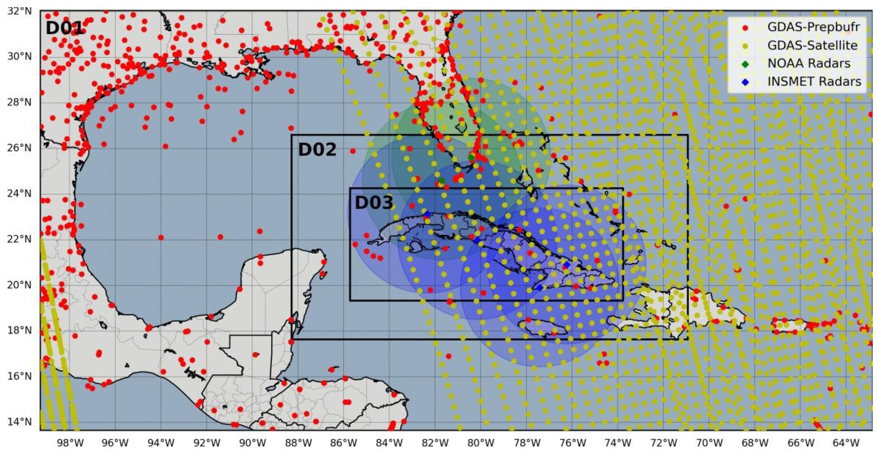
2. Materials and Methods

For the accomplishment of this work, the WRF-ARW model (version 4.1.2) and WRFDA module (version 4.3) were used [4]. The physical configurations taken into account in the model were defined by [1,2,3]. The WRFDA configuration was based on the studies of [10,11]. The assimilation of satellite and prepbufr data from the GDAS system was carried out for all domains (27, 9, and 3 km spatial resolution) (Figure 1). In the case of domain 3 (3 km), the data from the INSMET and NOAA radar network (KBYX and KAMX) were also assimilated, guaranteeing with this a total coverage of reflectivity information on the domain of the maximum spatial resolution.
The WRF model was initialized from GFS (Global Forecast System) forecast data with 0.5° horizontal resolution. A radar data conversion tool in the Nexrad Level II to FM-128 format implemented in Python by [8] was employed. The 3D-Var data assimilation method used in the WRF system [14] is capable of assimilating all types of conventional observations, as well as radar data. The 3D-Var system combines the observations with background information on the model state and uses a linearized forecast model to ensure that the observations are given a dynamically realistic and consistent analysis field [15]. The domain-dependent covariance matrix (BECs) used (CV7) was generated with the inclusion of hydrometeors and vertical velocity as control variables with a 1 month period of WRF (SisPI) outputs (initialization cycles of 0000 and 1200 UTC). Multiple outer loops (max_ext_its = 3) were utilized, where the multiplicative weight of its control variables was also modified (var_scaling = 1.0-0.5-0.25, len_scaling = 1.0-0.5-0.25). Table 1 describes the number of assimilated observations in each domain of the WRF model for the selected test case.
As a test case, the cold front that affected the western region of Cuba on 10 December 2018 was taken, which was preceded by a prefrontal squall line that caused heavy rains on the north coast of La Habana with significant accumulations in less than 3 h. The satellite image (Figure 2a) shows a frontal system that extends from a low- pressure center located on the east coast of the United States to Yucatan and the Gulf of Campeche. This cold front is preceded by low clouds that move over the Gulf of Mexico and the vicinity of the western region of Cuba. Ahead of this cold front, a line of storms can be seen, shown in the radar image (Figure 2b), which put on display reflectivity echoes from storm areas over La Habana.
Table 2 describes the experimental design to be carried out. Simulations without data assimilation (NoDA) were compared with simulations with (3DVAR noRain) and without (3DVAR) activating the radar_non_precip_opt option. For this, calculating metrics and obtaining maps from the simulated and observed meteorological variables were implemented in the Python programming language. For the evaluation of the experiments, 68 surface meteorological stations of the Institute of Meteorology, GOES-16 images, and Radar Observations were used. The radar data employed were acquired from https://www.ncdc.noaa.gov/nexradinv/index.jsp (accessed on 1 April 2022); GOES-16 data used were from https://home.chpc.utah.edu/~u0553130/Brian_Blaylock/cgi-bin/goes16_download.cgi (accessed on 1 April 2022), and the rest of the Bufr observation data and the GFS global model outputs were downloaded from https://rda.ucar.edu/ (accessed on 1 April 2022).

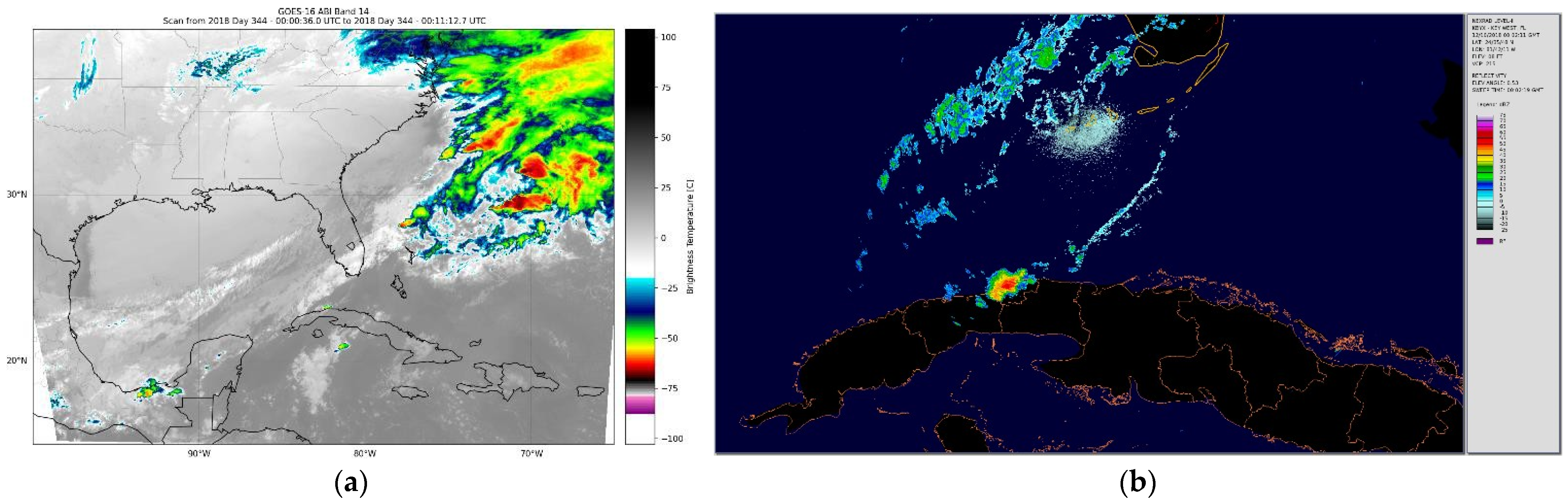
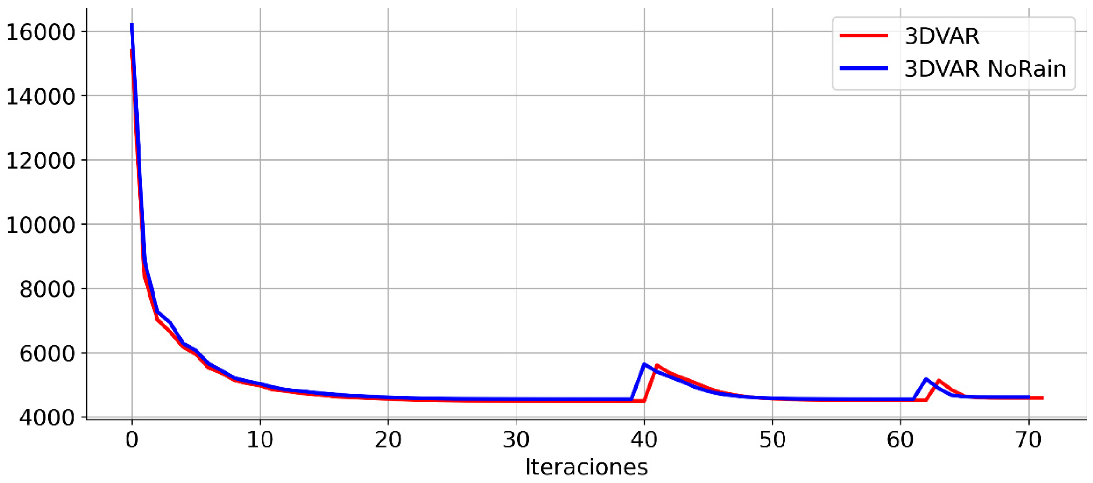
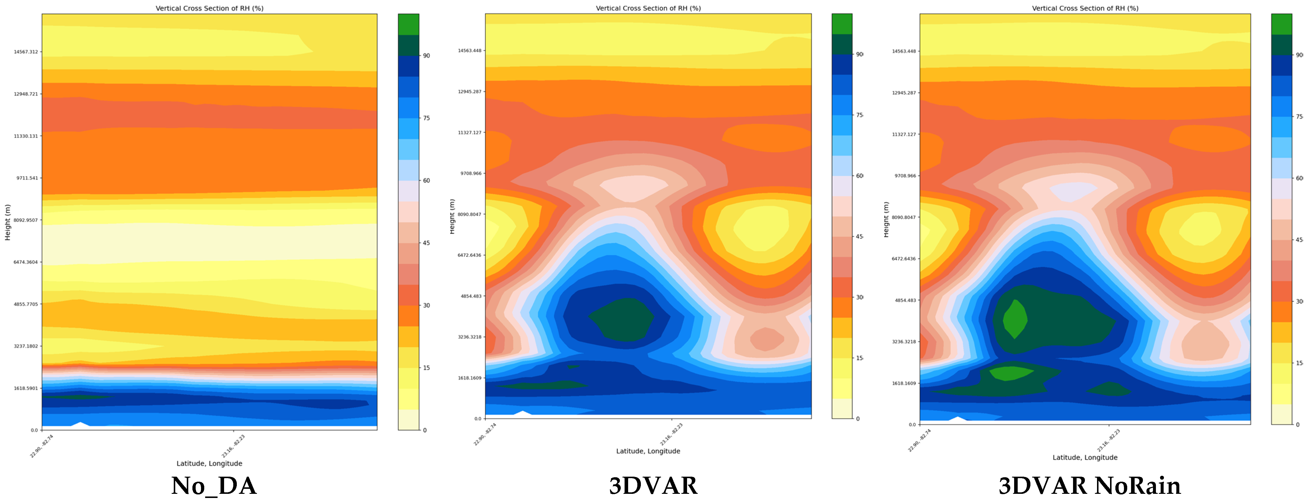
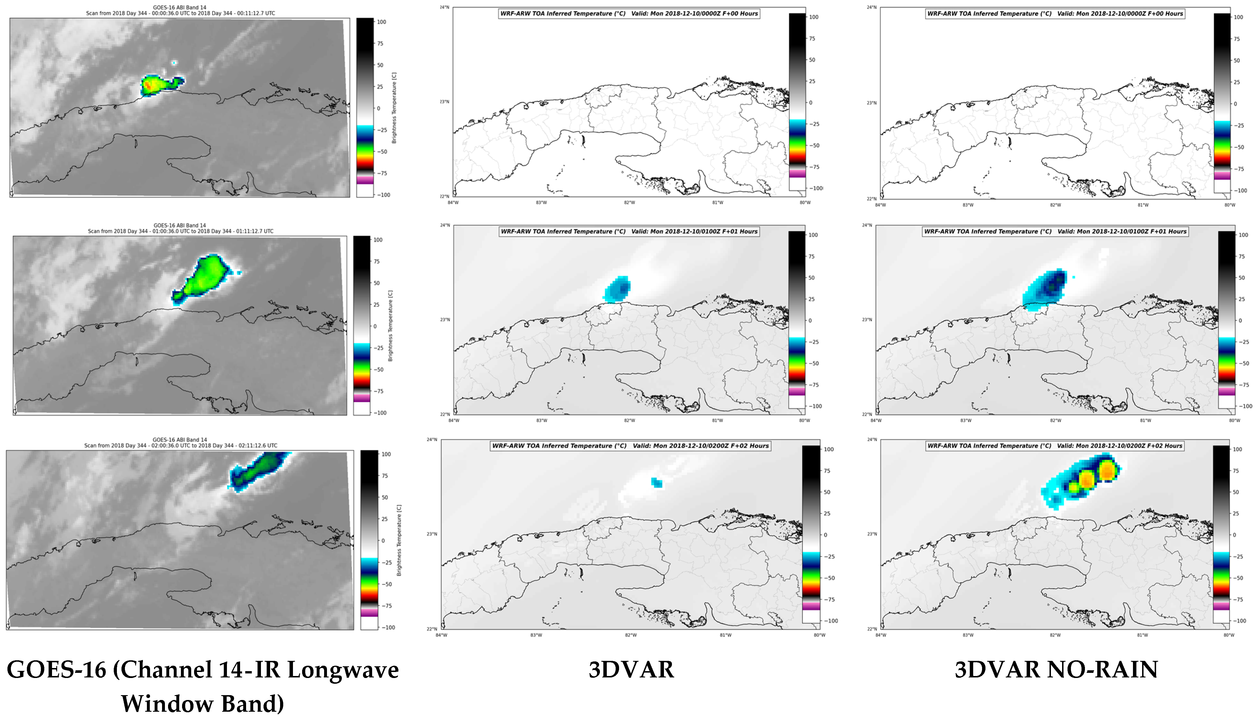
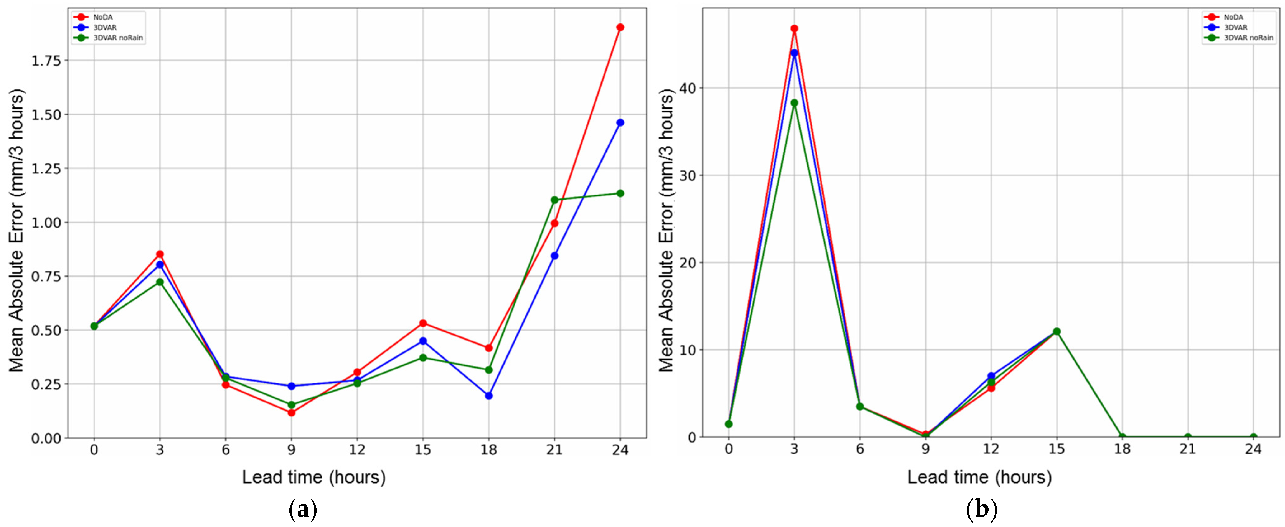
3. Results Discussion

Through the use of multiple outer loops, it is observed that the resulting cost functions show a great similarity, although the 3DVAR-NoRain configuration tends to minimize this function in fewer iterations (Figure 3).
Making vertical cross-sections in the relative humidity initialization fields for the different experiments, it could be seen over La Habana, in the case of simulations without data assimilation (No DA), how these did not take into account the influence on the vertical structure of the cloudy areas that are present in the study area. This is because they were the result of initializing only with low spatial resolution information from the GFS model, without inserting radar data or other observations types. On the other hand, both simulations with radar data assimilation inserted the influence of cloudy areas in the vertical structure of the relative humidity analysis fields obtained, which can be seen in Figure 4. When comparing the vertical cross-sections between the experiments with data assimilation, few differences were observed, although in the case of 3DVAR- noRain, an increase in the spatial distribution of relative humidity inside the cloud was observed, obtaining a more realistic structure of the convective storm present at the time of model initialization.
The comparison of the behavior of the brightness temperature values measured by the GOES-16 satellite corresponding to the first periods of the simulations (Figure 5) showed that the 3DVAR-noRain experiment obtained a greater ability to predict the areas of convective cloudiness associated with the prefrontal squall line, which maintained the activities of convective storm areas in the sea at the north of La Habana hours after the moment of initialization of the model. On the other hand, the 3DVAR experiment (without the radar_non_precip_opt option) attenuated the development of the convective process and did not adequately reflect the evolution of the cloud pattern associated with the squall line, which may be linked to differences in relative humidity analysis fields described in Figure 4.
In comparison with three-hourly precipitation observations of the INSMET station network (Figure 6a) and also specifically with the station of Casablanca (La Habana) (Figure 6b), which was affected by the rainfall associated with the prefrontal squall line, it was possible to determine that, despite the similar behavior of all the simulations, differences were observed in the first hours of the run, observing that the 3dvar-noRain experiment presented slightly lower mean absolute error values with respect to the rest of the simulations. These mean values during the simulation period ranged between 0.2 and 1.8 mm/3 h (Figure 6a) and between 0 and 48 mm/3 h (Figure 6b) for the case of accumulated precipitation measured at the Casablanca station.

4. Conclusions

The null-echo assimilation option proved to be an important option in the assimilation of radar data. It allows more realistic construction of moisture fields and its vertical structure in areas of observed reflectivity echoes. The use of this option contributes to improving the precipitation forecast and adequately reproduces the convective processes in the first time steps. The simulation with radar data assimilation but without the use of this option did not adequately represent the reflectivity echoes and the brightness temperatures of cloud tops in the first 2 h of simulation. The verification with synoptic station data showed that the use of the radar_non_precip_opt option made it possible to obtain lower mean absolute error values in the forecast of accumulated precipitation in the first 3 h of simulation.

Author Contributions

Conceptualization, M.S.L. and P.M.G.J.; methodology, P.M.G.J.; software, A.L.F.H.; validation, A.L.F.H.; formal analysis, A.L.F.H., D.d.l.C.A.F., M.S.L. and P.M.G.J.; investigation, D.d.l.C.A.F. and A.L.F.H.; resources, M.S.L.; data curation, A.L.F.H.; writing—original draft preparation, A.L.F.H.; writing—review and editing, A.L.F.H.; visualization, A.L.F.H.; supervision, M.S.L. and P.M.G.J.; project administration, M.S.L.; funding acquisition, M.S.L. All authors have read and agreed to the published version of the manuscript.

Funding

This research received no external funding.

Institutional Review Board Statement

Not applicable.

Informed Consent Statement

Not applicable.

Data Availability Statement

Not applicable.

Conflicts of Interest

The authors declare no conflict of interest.

References

  1. Sierra-Lorenzo, M.; Ferrer-Hernández, A.L.; Hernández-Valdés, R.; González-Mayor, Y.; Cruz-Rodríguez, R.C.; Borrajero-Montejo, I.; Rodríguez-Genó, C. Sistema Automático de Predicción a Mesoescala de Cuatro Ciclos Diarios; Technical Report; Instituto de Meteorología de Cuba: La Habana, Cuba, 2014. [Google Scholar] [CrossRef]
  2. Sierra-Lorenzo, M.; Borrajero-Montejo, I.; Ferrer-Hernández, A.L.; Hernández-Valdés, R.; Morfa-Ávalos, Y.; Morejón-Loyola, Y.; Hinojosa-Fernández, M. Estudios de Sensibilidad del Sispi a Cambios de la pbl, la Cantidad de Niveles Verticales y, las Parametrizaciones de Microfısica y Cúmulos, a muy alta Resolución; Technical Report; Instituto de Meteorología de Cuba: La Habana, Cuba, 2017. [Google Scholar]
  3. Alfonso Aguila, S.; Fuentes Barrios, A.; Sierra Lorenzo, M. Evaluation of the Nowcasting and very Short-Range Prediction System of the National Meteorological Service of Cuba. Environ. Sci. Proc. 2021, 8, 36. [Google Scholar] [CrossRef]
  4. Skamarock, W.C.; Klemp, J.B.; Dudhia, J.; Gill, D.O.; Liu, Z.; Berner, J.; Wang, W.; Powers, J.G.; Duda, M.G.; Barker, D.M.; et al. A Description of the Advanced Research WRF Version 4.1; OpenSky: Boulder, CO, USA, 2019; p. 145. [Google Scholar] [CrossRef]
  5. Hernández, R. Asimilación de Observaciones Meteorológicas con el Modelo Físico–Matemático ARPS; Trabajo Diploma; Instituto Superior de Tecnologías y Ciencias Aplicadas: La Habana, Cuba, 2013. [Google Scholar]
  6. Ferrer, A.L. Simulación Numérica de Tornados en Cuba; Trabajo Diploma; Instituto Superior de Tecnologíaas y Ciencias Aplicadas: La Habana, Cuba, 2013. [Google Scholar]
  7. Armas, E. Asimilación de Observaciones de Satélites Meteorológicos en el Modelo WRF; Trabajo Diploma; Instituto Superior de Tecnologías y Ciencias Aplicadas: La Habana, Cuba, 2015. [Google Scholar]
  8. Ferrer, A.L.; Borrajero, I. Estudio Preliminar Para La Implementación De La Asimilación De Datos De Radares Y Satélites Meteorológicos En Pronósticos Numéricos A Muy Alta Resolución Sobre La Región Occidental De Cuba. Informe de Resultado Científico Presentado en el Consejo Científico del Instituto de Meteorología de Cuba. 2019. Available online: http://repositorio.geotech.cu/jspui/bitstream/1234/4186/1/Estudio%20preliminar%20para%20la%20implementaci%C3%B3n%20de%20la20asimilaci%C3%B3n%20de%20datos%20de%20radares.pdf (accessed on 1 April 2022).
  9. Fernández, D. Corrección de Errores Sistemáticos en la Inicialización del Modelo WRF Utilizando Asimilación de Datos de Radar; Trabajo Diploma; Instituto Superior de Tecnologías y Ciencias Aplicadas: La Habana, Cuba, 2019. [Google Scholar]
  10. González, P.M.; Ferrer, A.L.; Aguiar, D.C.; Sierra, M. Determinación del Sistema de Asimilación de Datos a Utilizar, así Como de las Observaciones Meteorológicas que se Emplearán en SisPI; Consejo Científico del Instituto de Meteorología (INSMET): La Habana, Cuba, 2021. [Google Scholar]
  11. Aguiar, D. Comparación Entre los Métodos de Asimilación de Datos de Radar del WRFDA para su Implementación en SisPI; Trabajo Diploma; Instituto Superior de Tecnologías y Ciencias Aplicadas: La Habana, Cuba, 2021. [Google Scholar]
  12. Min, K.; Kim, Y. Assimilation of null-echo from radar data for QPF. In Proceedings of the 17th Annual WRF Users’ Workshop, Boulder, CO, USA, 27 June–1 July 2016; p. 78. [Google Scholar]
  13. Lee, J.-W.; Min, K.-H.; Lee, Y.-H.; Lee, G. X-Net-Based Radar Data Assimilation Study over the Seoul Metropolitan Area. Remote Sens. 2020, 12, 893. [Google Scholar] [CrossRef]
  14. Barker, D.M.; Huang, W.; Guo, Y.-R.; Bourgeois, A.J.; Xiao, Q.N. A Three-Dimensional (3DVAR) Data Assimilation System For Use With MM5: Implementation and Initial Results. Mon. Weather Rev. 2004, 132, 897–914. [Google Scholar] [CrossRef]
  15. Lee, Y.H.; Min, K.H. High-resolution modeling study of an isolated convective storm over Seoul Metropolitan area. Meteorol. Atmos. Phys. 2019, 131, 1549–1564. [Google Scholar] [CrossRef]
Figure 1. Domain configuration and meteorological observations used.
Environsciproc 19 00013 g001
Figure 2. Test case of 10 December 2018 at 0000 UTC: (a) GOES-16 (Channel 14) infrared image and (b) KBYX Radar reflectivity observation (Key West, Florida) at 0.5 elevation angle.
Environsciproc 19 00013 g002
Figure 3. Comparison of the cost functions of the experiments carried out.
Environsciproc 19 00013 g003
Figure 4. Vertical cross-sections of relative humidity of experiments with and without radar data assimilation.
Environsciproc 19 00013 g004
Figure 5. Comparison of the temperature of cloud tops observed by GOES-16 satellite with respect to outputs of WRF model assimilating radar data with (3DVAR noRain) and without (3DVAR) activating the null-echo option during the first 2 h of simulation.
Environsciproc 19 00013 g005
Figure 6. Mean absolute error (mm/3 h) of precipitation forecast: (a) verification with 68 synoptic stations of INSMET and (b) verification with Casablanca (La Habana) synoptic station (WMO 78325).
Environsciproc 19 00013 g006
Table 1. Number of assimilated observations in each simulation domain.
OBS TypesDomain 01Domain D02Domain D03
Airep8
Soundings154
Metar3253211
Ship43219
Synop76103
Buoy12311
Radiance1909438153
Radar2404
Total24995162580
Table 2. Experimental design.
Experiment NameDescription
NoDA No data assimilation
3DVARGFS + GDAS + Radar
3DVAR_noRainGFS + GDAS + Radar + Null echoes
Publisher’s Note: MDPI stays neutral with regard to jurisdictional claims in published maps and institutional affiliations.

