Proceeding Paper

A Quantitative Approach to Air Traffic Safety at Very Low Levels †

by
Xavier Olive
1,*,‡ and
Patrick Le Blaye
2,*,‡
1
ONERA DTIS, Université de Toulouse, 2, avenue Édouard Belin, 31055 Toulouse, France
2
ONERA DTIS, BA 701, Salon CEDEX Air, 13661 Salon-de-Provence, France
*
Authors to whom correspondence should be addressed.
Presented at the 10th OpenSky Symposium, Delft, The Netherlands, 10–11 November 2022.
These authors contributed equally to this work.
Eng. Proc. 2022, 28(1), 1; https://doi.org/10.3390/engproc2022028001
Published: 13 December 2022
(This article belongs to the Proceedings of The 10th OpenSky Symposium)

Abstract

:
A safe integration of drone operations at very low levels, especially for beyond visual line-of-sight operations, must come with proper modeling of the mid-air collision risk at lower altitudes. In this paper, we present a state-of-the-art quantitative model for the air risk assessment of unmanned aircraft system (UAS) operations and illustrate how cooperative technologies such ADS-B and FLARM, together with networks of compatible ground receivers, are crucial to provide the traffic data required to support this model. An application over an area of Southeastern France is presented. The results suggest that the collected traffic data allow accurate analyses of the spatial and temporal variation of traffic types and density at lower altitudes, and can thus support an objective assessment of the risk of collision of UAS with manned traffic.

1. Introduction

Collision risk modeling at lower altitudes is a key topic to keep the skies safe for all actors of General Aviation, including private jets, ultralights, gliders, and helicopters. Low altitude activities also include those of armed forces, firefighters, or search and rescue operations. The matter is also of particular interest to define subsets of airspace and time intervals when unmanned aircraft systems (UAS), also known as drones, can safely operate.
The European Commission issued Regulation 1207/2011 mandating the Single European Sky [1]. As part of this, ADS-B usage is mandated on an aircraft built after 8 January 2015, and for all aircraft by 7 December 2017. Regulation 1028/2014 later modified this, pushing the deadline to June 2020 [2]. Later, the deadline was pushed back again by Regulation 2020/587 [3], adding a transitional period and exemptions for older aircraft, up to 2023 and 2025, respectively. The European Commission’s mandate applies to most commercial aviation (with maximal take-off mass exceeding 5700 kg or maximal cruise speed greater than 250 knots) but many light or slow aircraft remain unequipped. From a surveillance point of view, the common practice is to distinguish two types of traffic: cooperative aircraft are equipped with electronic means of signaling and identification (Mode A/C or Mode S transponders, ADS-B, FLARM or equivalent, Wi-Fi for drones) and non-cooperative traffic, unequipped or stealth, only visible with a primary radar, camera or directly.
The recent development of beyond visual line-of-sight (BVLOS) drone operations poses a new risk to the legacy users operating at low altitudes. These drones typically operate at very low levels (VLL), e.g., below 120 m above ground level, where manned aircraft may also occasionally fly (e.g., for take-off and landing, training exercises, medical evacuation, or aerial work). Electronic conspicuity has been mandated for drones primarily for security reasons (police control) and will be mandated for manned aircraft willing to operate within a U-space airspace [4].
In this paper, we address the topic of safety at lower altitudes with the aim to characterize the traffic and to assess the collision risk. Section 2 describes a state-of-the-art model for collision risk applicable to UAS operations and illustrates how cooperative technologies are crucial to ensure proper detection of surrounding traffic without delay. Section 3 attempts to give an overview of all that can be visible with cooperative traffic in Western Europe with data collected through the OpenSky Network [5], including ADS-B and FLARM. Section 4 focuses on a case study over an area of Southeastern France covering a wide variety of landscapes (plains and foothills) and aircraft activities (Marseille–Provence airport, military air bases, firefighting activities, and local flight clubs) and using ground receivers of ADS-B and FLARM signals, before a conclusion in Section 5.

2. Collision Risk Assessment

2.1. Qualitative Risk Assessment with SORA Methodology

Drone BVLOS operations at VLL most often present a moderate level of risk and thus belong to the “Specific” category under the European regulation [6]. These operations are subject to approval by the authority based on a risk analysis performed by the operator using the Specific Operation Risk Assessment (SORA) methodology [7]. This methodology consists of a step-by-step parallel assessment of ground and air risks, the latter being related to the collision with a manned aircraft or another UA. The SORA was initially developed by JARUS based on an air risk collision model which has been submitted to consultation in 2018 [8] but remains unpublished at this time.
The air risk collision model of SORA is primarily qualitative and relies on an initial risk classification using a decision tree (Annex C in [7]), depending on the environment (airport/heliport), the altitude (e.g., VLL), the airspace class (controlled/uncontrolled), and the type of area (urban/rural). The classification is based on a ponderation of three variables (proximity/density, geometry/structure, and dynamics) and results in 12 airspace encounter categories (AEC) with associated air risk class (ARC) ranging from no risk to high risk. The operator may claim for a lower ARC by demonstrating that the actual traffic density is lower than assumed. The final air risk is determined in the next steps after consideration of strategic and tactical mitigation measures.
This qualitative approach aims to facilitate the risk assessment by the operator, as its only input is the concept of operation, with no consideration of the actual traffic within the operational volume. It relies to a large extent on subjective assessments, and studies are needed to assess whether it correctly captures the actual level of risk [9,10,11]. However, SORA leaves to the competent authority the possibility to “directly map the airspace collision risks using airspace characterization studies”, which indeed requires an extensive collection of actual traffic data over the foreseen operational volume and its surroundings.
Moreover, the recent European regulatory framework for the U-space [12] specifies that the designation of U-space airspace shall be supported by an airspace risk assessment, taking into account “the type, complexity, and density of the traffic, the location, altitudes, or heights and the airspace classification”. Capabilities and performance requirements for the UAS shall also be determined based on this assessment. This regulation is complemented by requirements for the manned aircraft willing to operate in such airspace to be electronically conspicuous to the U-space service providers [4]. Acceptable means of compliance and guidance have been proposed regarding the assessment process [13], recognizing the value of both qualitative and quantitative analysis and the need for iteration considering the achieved and perceived risks, including hazard mitigation.

2.2. Quantitative Risk Modeling

Hereafter, we focus on collision risk between unmanned and manned aircraft, which is actually the prominent issue for UAS air traffic integration. Collisions between UA can be considered of a differing nature, as they involve risk of fatalities or damage on the ground.
The objective of the air risk assessment is to ensure that the risk of mid-air collision (MAC) for a particular operation is below a target level of safety (TLS), which for General Aviation is generally determined as 10 7 per flight hour. We adopt the approach of SORA, where the overall risk depends on the initial “ambient”, unmitigated, collision risk rate and on strategic or tactical mitigations when required to reach the TLS.
The collision risk rate is typically decomposed as follows [14,15]:
MAC rate = p MAC | NMAC · p NMAC | Enc · Enc rate
  • MAC rate is the number of MAC per flight hour, expected to be lower than the TLS;
  • p MAC | NMAC is the probability of MAC given that a near mid-air collision (NMAC) occurred. NMAC refers to a situation when two aircraft come closer than 500 feet horizontally and 100 feet vertically. p MAC | NMAC reflects the role of (lack of) providence in collision avoidance. It is estimated at 10 2 , taking into account the small dimension of the UA compared to the typical dimensions of manned aircraft [16].
  • p NMAC | Enc is the probability of an NMAC provided an encounter has occurred;
  • Enc rate is the number of encounters per flight hour.
The two former parameters depend on the encounter definition. An encounter can be described as a situation where two aircraft come as close as to potentially pose a collision risk, such as the case where a manned aircraft flies into the vicinity of the drone operational volume and can be considered as an intruder, requiring attention from the remote pilot.
For the purpose of risk modeling and traffic data collection, we consider an encounter as the situation where surrounding traffic enters a surveillance volume spatially defined as a cylinder. The larger this volume, the higher is the encounter rate and correlatively, the lower is the probability p NMAC | Enc . The definition results from a compromise, i.e., the choice of an adequate granularity for traffic data collection. If it is chosen too large, the encounter rate may not adequately represent situations particular to the intended operation, and if it is too small, some relevant traffic patterns (e.g., high speed) may not be captured.
For a given surveillance volume, p NMAC | Enc can be estimated through geometric calculation and further refined by means of numerical simulations [14], while Enc rate depends on the traffic density which can be derived from actual observations of the traffic, as described in the next sections. Note that an alternative form of Equation (1) can be used considering well clear violations (WCV) instead of encounters. In particular, the SORA refers to work by MIT [16] regarding the well clear definition for small UAS, weighting less than 55 pounds and operating below 1200 feet AGL at a maximum speed of 60 knots, which recommended a well clear volume of 2000 feet horizontally and 250 feet vertically, providing a value of p NMAC | WCV equal to 10 1 .
When it comes to collecting traffic data relevant to UA operations below 500 feet AGL, the following assumptions have been made based on experience reported by UAS operators and observation of flight profiles of General Aviation aircraft:
  • Maximum ground speeds are assumed to be 60 knots for the UA and 250 knots for the manned aircraft (maximum allowed speed below FL 100), with 95% below 170 knots.
  • A minimal look-ahead time of 30 s before loss of separation is considered necessary for the UA to detect and avoid a possible loss of separation with an incoming manned aircraft, considering the need to not scare the pilot of the manned aircraft. As a reference, the maximum time for the first level of alert of a FLARM device is around 25 s before collision [17] and TCAS alerting time is 25 s below 2350 feet AGL and 20 s below 1000 feet AGL [18]. Note that the trajectory prediction of GA aircraft is complicated by the uncertainties due to lack of inertia and the possibly high turn and vertical rates, so that predictions with a look-ahead time higher than 30 s are considered unreliable.
  • In the worst case of a head-on conflict, the relative closing speed is thus 310 knots (or 230 knots at 95%). Adding the resulting distance flown in 30 s and the recommended separation of 2000 feet, the required horizontal distance for considering surrounding traffic as an intruder is about 5000 m.
The vertical dimension is particularly determining for VLL operations, as the manned traffic density increases rapidly with altitude (see Figure 6 in Section 4). Manned traffic usually only transits through the low altitude levels, with moderate vertical rates. Considering a continuous climb or descent at a gradient of 5% over the horizontal distance of 5000 m, the possible altitude variation is 250 m (820 feet). Adding the recommended separation of 250 feet gives a relative vertical distance for the surveillance volume around 1100 feet. When it comes to collect traffic data for VLL operations limited to 500 feet AGL, the manned traffic may thus be considered relevant when it flies below 1600 feet AGL.

3. Cooperative Aircraft Detection at Very Low Levels

3.1. ADS-B

ADS-B (Automatic Dependent Surveillance—Broadcast) is a technology based on transceivers, electronic on-board devices which help to identify aircraft on air traffic control (ATC) radars. Alike to transponders, transceivers produce signals on the 1090 MHz frequency but do not require interrogations. The FAA and the European Commission issued regulations to mandate aircraft to be ADS-B compliant, but these mostly apply to large aircraft flying in designated airspaces.
ADS-B data collection for en route commercial aircraft is usually rather easy to achieve with proper receivers, which are at best limited by the radio horizon and yield a coverage range of about 400 km. Coverage usually decreases with altitude and is affected by surrounding buildings and mountain relief. Figure 1 shows a correlation between low altitude coverage, receivers’ locations and mountains over Western Europe. Low altitude coverage in France is therefore limited to densely populated (more chances to get a potential feeder there), lower altitude or flat areas (fewer chances to be affected by surrounding mountains). Low altitude ADS-B coverage is also affected by the very low equipage rate for General Aviation aircraft, as we documented in [19]: as a result, even a decent receiver with a good low altitude coverage will not provide any trajectory information for a significant part of General Aviation aircraft.

3.2. FLARM

FLARM is, with TCAS [20], one of the most widespread technologies for traffic awareness and collision avoidance, initially designed for gliders, light aircraft, rotorcraft, and drones. FLARM obtains its position and altitude readings from a GPS antenna and an internal barometric sensor, then broadcasts these together with forecast data about the future 3D flight track. At the same time, its receiver listens for other FLARM devices within range and processes the information received.
The wireless nature of FLARM allows for the reception of signals in a crowdsourced fashion. Although the FLARM radio protocol features message encryption in order to ensure integrity and confidentiality, implementation and encryption keys are available: the Open Glider Network (OGN) maintains a tracking platform with the help of many receivers, mostly collocated with flying clubs operating light aircraft at local airfields. The OpenSky Network (OSN) also collects FLARM raw messages, with data accessible to institutional researchers. Despite fewer receivers currently feed OSN, access to historical data is possible, allowing for proper analyses. Figure 2 plots the low-altitude coverage for the OpenSky Network and the Open Glider Network in Western Europe: it is similarly affected by surrounding relief and receivers’ location.

3.3. Mode A/C and Mode S Transponders, Multilateration
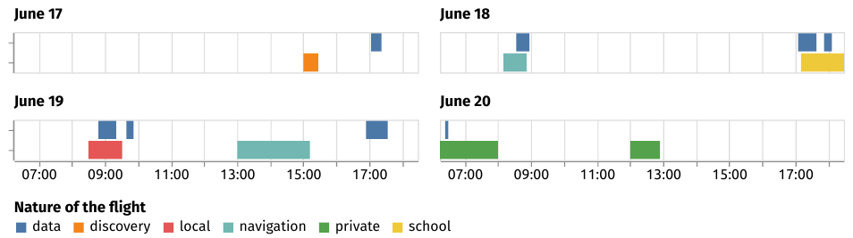
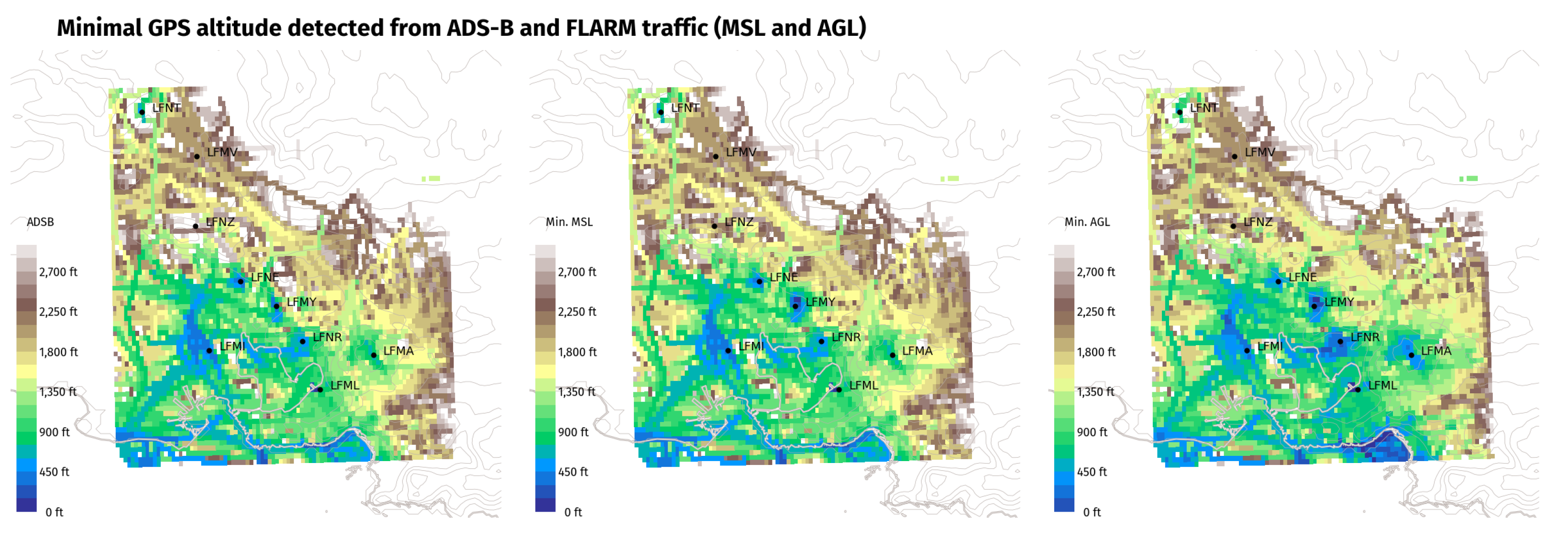
The transponders equipping most General Aviation aircraft are Mode A/C transponders only: they reply to Secondary Surveillance Radars (SSR) with squawk (Mode 3/A) and altitude information (Mode 3/C), by increments of 100 ft. Mode S is a further extension of Mode A/C where queries are addressed to specific aircraft (S stands for selective).
All ADS-B receivers, including those feeding the OpenSky Network decode and record the raw messages associated with squawk and altitude information which can further be related to the flight logs of any airborne aircraft within range (cf. Section 4). Even without any precise localization information, receivers receiving squawk and altitude messages from any aircraft equipped with a transponder can relate that piece of information with probable activity in the neighborhood and around the air field where the aircraft is based.
When an aircraft is within coverage of at least four synchronized receivers, multilateration is a technique designed to estimate the localization of the aircraft. Multilateration is based on the optimization of a quadratic problem relating the differences between times of arrival of messages to the differences between distances between the aircraft and all receivers within range. Provided that clock drift is properly estimated, clocks with a nanosecond precision (GPS clocks) may reduce the uncertainty to the order of magnitude of a meter in the estimation of the aircraft’s localization.

4. Case Study

In this section, we focus on data collected between 15th and 30th June 2022 by our ground receiver located on the Salon-de-Provence Air Base (BA 701), collecting ADS-B and FLARM data and feeding the OpenSky Network. This area in Southeastern France, near Marseille, is of particular interest for this study as it hosts a wide variety of landscapes (plains and foothills) and aircraft activities are displayed in Table 1.
Table 2 decomposes all the detected traffic with ADS-B and FLARM data: most ADS-B traffic comes from commercial activity at Marseille–Provence (LFML or MRS); most FLARM data stem from gliders operating at LFMY (military school) or LFNZ (local civil gliding club). Visible military activity comes mostly from air tankers taking off from the LFMI air base and heading for in-flight refueling training in designated areas. Remaining trajectories are mostly helicopters commuting with hospitals heliports, performing firefighting activities or manufacturers tests (Airbus Helicopters).
We found that even local flight clubs showing good will in investing for safety may lack technical background and mistakenly think their aircraft is ADS-B-compliant after they equipped it with a transponder. Even though Mode A/C transponders do not send positional information (other than barometric altitude and callsign), detecting a signal from a known aircraft from a local flight club is precious information about traffic density in the neighborhood. Figure 3 compares the data detected for one aircraft with the flight logs kept by a local flight club at Eyguières LFNE: apart from UTC vs. local time (UTC+2) confusion in the keeping of the flight logs by different people, our receiver detects and correctly logs local activity (discovery flight, local flight, school flight) of the aircraft.
Figure 4 reflects the difference in philosophy between ADS-B and FLARM technologies: ADS-B is a surveillance technology where aircraft broadcast their current position; FLARM is a collision avoidance technology where aircraft estimate their future position. Reported GPS altitudes (FLARM only reports GPS altitude, using the metric system) may not match, as they do not represent the same estimation.
Figure 5 shows that on a relatively short time period and despite the lack of an extended network for FLARM data collection, traffic is very likely to operate at low altitudes (i.e., below 1200 feet AGL) over a large share of the covered area. The possibility of interference with VLL UAS operations cannot be ignored. The resolution of traffic data visualization is high enough (the grid creates 100 points per latitude and longitude degrees) to reveal local traffic patterns and to allow for a precise analysis of possible encounters along the planned UAS trajectory. The figure also confirms the complementarity of FLARM and ADS-B data: both technologies cover different types of traffic and different regions. Moreover, aircraft equipped with FLARM constitute a significant part of traffic at lower altitudes.
Figure 6 highlights the variation of traffic density with AGL altitude layers over the same day of two consecutive weeks. As expected, coverage below 500 feet is limited to the immediate surroundings of the receiver located at LFMY and only local traffic for take-off and landing is visible, together with some glider activity over the hills between LFNE and LFNZ. On the intermediate altitude layer (500 to 1200 feet), particularly relevant with regard to UAS operations, patterns of VFR traffic are visible even far from the receiver. More IFR traffic appears on the third layer. Discrepancies between the two days suggest that traffic density should be considered over time, rather than through a maximal or mean value.
In contrast with the SORA qualitative approach, data reveal that local variations of traffic density at low altitudes have to be accounted for air risk assessment. A drone inspection mission of the TGV fast train line, in double lines on the figure, is a very realistic use case: between LFMA and LFMV, the area close to LFMY will be most critical, crossing an area of possible low-altitude flights. Moving the surveillance volume along the line, the number of aircraft which may be encountered can be calculated along the UAS flight trajectory leading to the encounter and NMAC rates, as described in Section 2.

5. Conclusions

This paper describes a possible path for air risk assessment using traffic data at lower altitudes. The feasibility of the approach is shown at a regional scale. Some gaps are also identified before the approach can be further extended and formalized. In particular, the number of receivers feeding the existing networks with FLARM data is still small and, as a consequence, low-altitude traffic data are not available over large portions of the European territory. Hopefully, the coverage will expand in the future in relationship with the development of surveillance technologies and services associated to the U-space.

Author Contributions

Conceptualization, X.O. and P.L.B.; methodology, X.O. and P.L.B.; software, X.O.; validation, X.O. and P.L.B.; formal analysis, X.O. and P.L.B.; investigation, X.O. and P.L.B.; resources, X.O. and P.L.B.; data curation, X.O.; writing—original draft preparation, X.O. and P.L.B.; writing—review and editing, X.O. and P.L.B.; visualization, X.O. All authors have read and agreed to the published version of the manuscript.

Funding

This research was funded by the French Directorate General for Civil Aviation (DGAC) in the context of the research partnership PHYDIAS for safety improvement of UAS.

Institutional Review Board Statement

Not applicable.

Informed Consent Statement

Not applicable.

Data Availability Statement

Data used to support this research and the visualizations are for the most part available from the OpenSky Network historical database.

Acknowledgments

The authors would like to thank the aero clubs of LFNE for providing information on their activity and the flight logs used to build Figure 3. Giorgio Tresoldi also provided great assistance in processing and understanding collected FLARM data on the OpenSky Network database.

Conflicts of Interest

The authors declare no conflict of interest.

References

  1. The European Commission. Commission Regulation No. 1207/2011 of 22 November 2011 Laying Down Requirements for the Performance and the Interoperability of Surveillance for the Single European Sky; The European Commission: Brussels, Belgium, 2011. [Google Scholar]
  2. The European Commission. Implementing Regulation (EU) No. 1028/2014 Amending Implementing Regulation (EU) No. 1207/2011; The European Commission: Brussels, Belgium, 2014. [Google Scholar]
  3. The European Commission. Implementing Regulation (EU) No. 2020/587 Amending Implementing Regulation (EU) No. 1206/2011 Laying Down Requirements on Aircraft Identification for Surveillance for the Single European Sky and Implementing Regulation (EU) No. 1207/2011 Laying Down Requirements for the Performance and the Interoperability of Surveillance for the Single European Sky; The European Commission: Brussels, Belgium, 2020. [Google Scholar]
  4. The European Commission. Commission Implementing Regulation (EU) 2021/666 of 22 April 2021 Amending Regulation (EU) No. 923/2012 as Regards Requirements for Manned Aviation Operating in U-Space Airspace; The European Commission: Brussels, Belgium, 2021. [Google Scholar]
  5. Schäfer, M.; Strohmeier, M.; Lenders, V.; Martinovic, I.; Wilhelm, M. Bringing Up OpenSky: A Large-scale ADS-B Sensor Network for Research. In Proceedings of the 13th IEEE/ACM International Symposium on Information Processing in Sensor Networks (IPSN), Berlin, Germany, 15–17 April 2014. [Google Scholar]
  6. The European Commission. Commission Implementing Regulation (EU) 2019/947 of 24 May 2019 on the Rules and Procedures for the Operation of Unmanned Aircraft; The European Commission: Brussels, Belgium, 2019. [Google Scholar]
  7. EASA. AMC and GM to Commission Implementing Regulation (EU) 2019/947—Issue 1; EASA: Cologne, Germany, 2019. [Google Scholar]
  8. Annex G Air Risk Collision Model (Draft for External Consultation, 2018-10-19); JARUS Guidelines on Specific Operations Risk Assessment (SORA); Joint Authorities for Rulemaking of Unmanned Systems, 2018.
  9. Martin, T.; Huang, Z.F.; McFadyen, A. Airspace Risk Management for UAVs—A Framework for Optimising Detector Performance Standards and Airspace Traffic using JARUS SORA. In Proceedings of the IEEE/AIAA 37th Digital Avionics Systems Conference (DASC), London, UK, 23–27 September 2018; pp. 1516–1525. [Google Scholar] [CrossRef]
  10. la Cour-Harbo, A. The Value of Step-by-Step Risk Assessment for Unmanned Aircraft. In Proceedings of the International Conference on Unmanned Aircraft Systems (ICUAS), Dallas, TX, USA, 12–15 June 2018; pp. 149–157. [Google Scholar] [CrossRef] [Green Version]
  11. Sedov, L.; Polishchuk, V.; Maury, T.; Ulloa, M.; Lykova, D. Qualitative and quantitative risk assessment of urban airspace operations. In Proceedings of the 11th SESAR Innovation Days, Online, 7–9 December 2021. [Google Scholar]
  12. The European Commission. Commission Implementing Regulation (EU) 2021/664 of 22 April 2021 on a Regulatory Framework for the U-Space; The European Commission: Brussels, Belgium, 2021. [Google Scholar]
  13. EASA. NPA 2021-14—Development of Acceptable Means of Compliance and Guidance Material to Support the U-Space Regulation; EASA: Cologne, Germany, 2021. [Google Scholar]
  14. Kochenderfer, M.; Kuchar, J.; Espindle, L.; Griffith, J. Uncorrelated Encounter Model of the National Airspace System, Version 1.0; Technical Report, MIT/LL Project Report ATC-345; Lincoln Laboratory, Massachusetts Institute of Technology: Lexington, MA, USA, 2008. [Google Scholar]
  15. Kochenderfer, M.; Griffith, D.; Olszta, J. On Estimating Mid-Air Collision Risk. In Proceedings of the 10th AIAA Aviation Technology, Integration, and Operations (ATIO) Conference, Fort Worth, TX, USA, 13–15 September 2010. [Google Scholar] [CrossRef]
  16. Weinert, A.; Campbell, S.; Vela, A.; Schuldt, D.; Kurucar, J. Well-Clear Recommendation for Small Unmanned Aircraft Systems Based on Unmitigated Collision Risk. J. Air Transp. 2018, 26, 113–122. [Google Scholar] [CrossRef] [Green Version]
  17. FLARM Technology Ltd. Operating Manual FLARM Collision Avoidance System, version 242; FLARM Technology Ltd.: Zug, Switzerland, 2016. [Google Scholar]
  18. Eurocontrol. ACAS Guide—Airborne Collision Avoidance Systems, 4.1th ed.; Eurocontrol: Brussels, Belgium, 2022. [Google Scholar]
  19. Sun, J.; Olive, X.; Strohmeier, M.; Schafer, M.; Martinovic, I.; Lenders, V. OpenSky Report 2021: Insights on ADS-B Mandate and Fleet Deployment in Times of Crisis. In Proceedings of the 40th IEEE/AIAA Digital Avionics Systems Conference (DASC), San Antonio, TX, USA, 3–7 October 2021. [Google Scholar] [CrossRef]
  20. Schafer, M.; Olive, X.; Strohmeier, M.; Smith, M.; Martinovic, I.; Lenders, V. OpenSky Report 2019: Analysing TCAS in the Real World using Big Data. In Proceedings of the 38th IEEE/AIAA Digital Avionics Systems Conference (DASC), San Diego, CA, USA, 8–12 September 2019. [Google Scholar] [CrossRef]
Figure 1. ADS-B coverage (minimal altitude detected) below 10,000 ft for aircraft with a non-commercial callsign over Western Europe (left) with mountain relief (right). Red dots match the location of receivers actively feeding the OpenSky Network on the same day.
Engproc 28 00001 g001
Figure 2. FLARM coverage (minimal altitude detected) for equipped aircraft. Red dots match the location of receivers feeding the OpenSky Network (left) and the Open Glider Network (right).
Engproc 28 00001 g002
Figure 3. Comparison of detected activity based on Mode A/C data with flight logs for a private aircraft based at Eyguières airfield LFNE nearby our LFMY receiver. In spite of no ADS-B-compliant equipment, it is possible to detect a local activity of the aircraft.
Engproc 28 00001 g003
Figure 4. Aircraft F-JVZB (identifier 394f3c) is equipped with both ADS-B and FLARM. Different GPS altitude data are however emitted: ADS-B broadcasts the aircraft current position, while FLARM estimates the position of the aircraft two seconds in the future for collision avoidance purposes.
Engproc 28 00001 g004
Figure 5. This minimal GPS altitude coverage map shows the importance of FLARM receivers when detecting traffic at VLL, especially near General Aviation airfields. VLL traffic (ambulance, firefighting) is also highlighted along the littoral, near downtown Marseille in the southeast.
Engproc 28 00001 g005
Figure 6. Density maps on various days (or various hours of days) reflect different levels of activity, even on the same day of the week (Wednesday). Activity above 1200 ft may look similar on both days, but activity below 1200 ft looks denser on 29 June 2022.
Engproc 28 00001 g006
Table 1. The case study spans over many airfields and covers a wide range of aeronautical activities. Flights with ADS-B coverage and tagged as landing or taking-off from these airfields were counted in the appropriate column of the table.
FlightsAirport or Airfield
LFMA223Aix-Les MillesGeneral Aviation, Guimbal (helicopters)
LFMI263Istres Le Tubé (BA 125)Military activity, flight test center
LFML4120Marseille ProvenceCommercial hub, Airbus Helicopters
LFMV94Avignon CaumontLow-cost seasonal hub, General Aviation
LFMY39Salon-de-Provence (BA 701)Military, aerobatics, gliders (receiver location)
LFNEEyguièresGeneral Aviation, gliders, ultralights
LFNTAvignon PujautGeneral Aviation, parachute drop-out
LFNRBerre-la-FareGeneral Aviation
LFNZSaint-Rémy-de-ProvenceGliders
LFTWNîmes-GaronsLow-cost hub, Sécurité Civile (firefighters)
Table 2. The ADS-B and FLARM datasets cover a wide range of activities: commercial, military, test flights by manufacturers, ambulance (Life and Rescue), firefighting, General Aviation including ultralights and gliders. Four aircraft have been detected in both datasets.
FlightsAircraftCategory
57661111ADS-B dataset
4546866commercialmostly operating to/from LFML
16126militaryFAF callsign, air tankers, etc.
10613test flights (F-W*)Airbus and Guimbal helicopters
13410Sécurité Civile (fire)MILAN, DRAG, BENGA callsigns
724Life & RescueSAMU callsign helicopters
895247General Aviation
650128FLARM dataset
9919Aircraft
9315incl.also equipped with a transponder
404incl.also ADS-B compliant
418105Glider
11438incl.also equipped with a transponder
765Tow-plane
481Parachute Drop-Planearound LFNT in the north
95Helicopteralso equipped with a transponder
11Paraglider
Publisher’s Note: MDPI stays neutral with regard to jurisdictional claims in published maps and institutional affiliations.

