
Archeoseismic Study of Damage in Medieval Monuments around New Delhi, India: An Approach to Understanding Paleoseismicity in an Intraplate Region

 , , ,
, , ,
Abstract
:1. Introduction

| Earthquake Events | Epicentral Location | Magnitude | Intensity | Areas | Effects |
|---|---|---|---|---|---|
| 6 June 1505 | - | Mw = 8.2–8.9 | Felt around Delhi and Agra; no major damage to historical monuments | ||
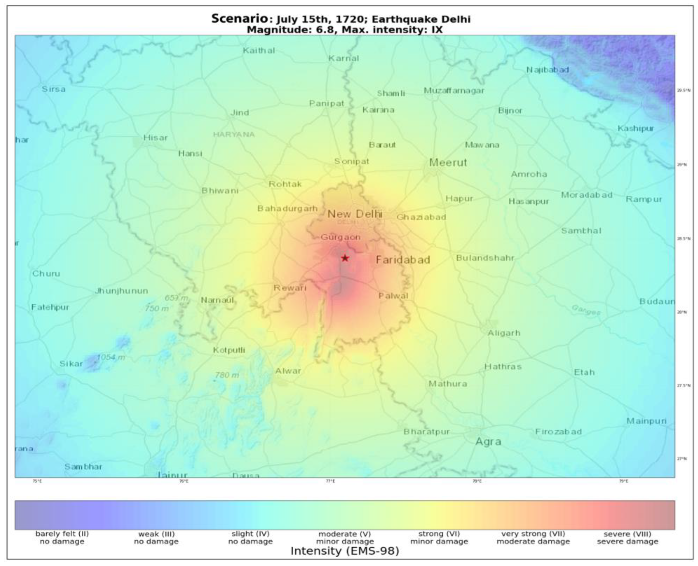
| 15 July 1720 | 28.37° N–77.10° E | Mw = 6.5 | IX | Delhi | Extensive damages observed in Old Delhi Damaged the old Delhi fortress and many buildings |
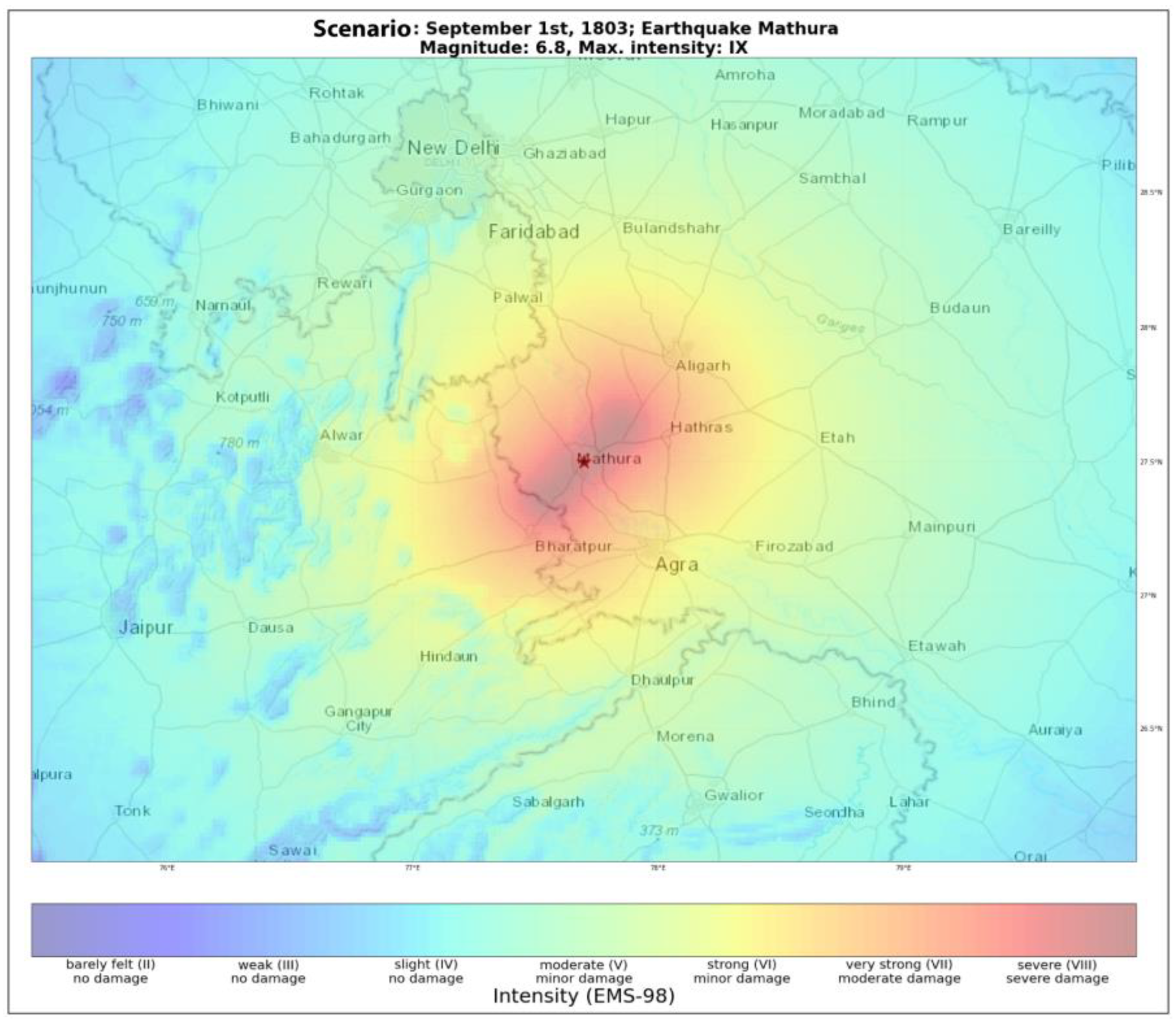
| 1 September 1803 | 27.50° N–77.70° E | Ms = 7.5/Mw = 6.8 | IX | Mathura/Kumaun | Felt severely in Delhi and caused extensive damage to buildings and also some loss of life |
| 10 October 1956 | 28.15° N–77.67° E | Mw = 6.7 | VII | Near Bulandshahar | Minor damage in Delhi |
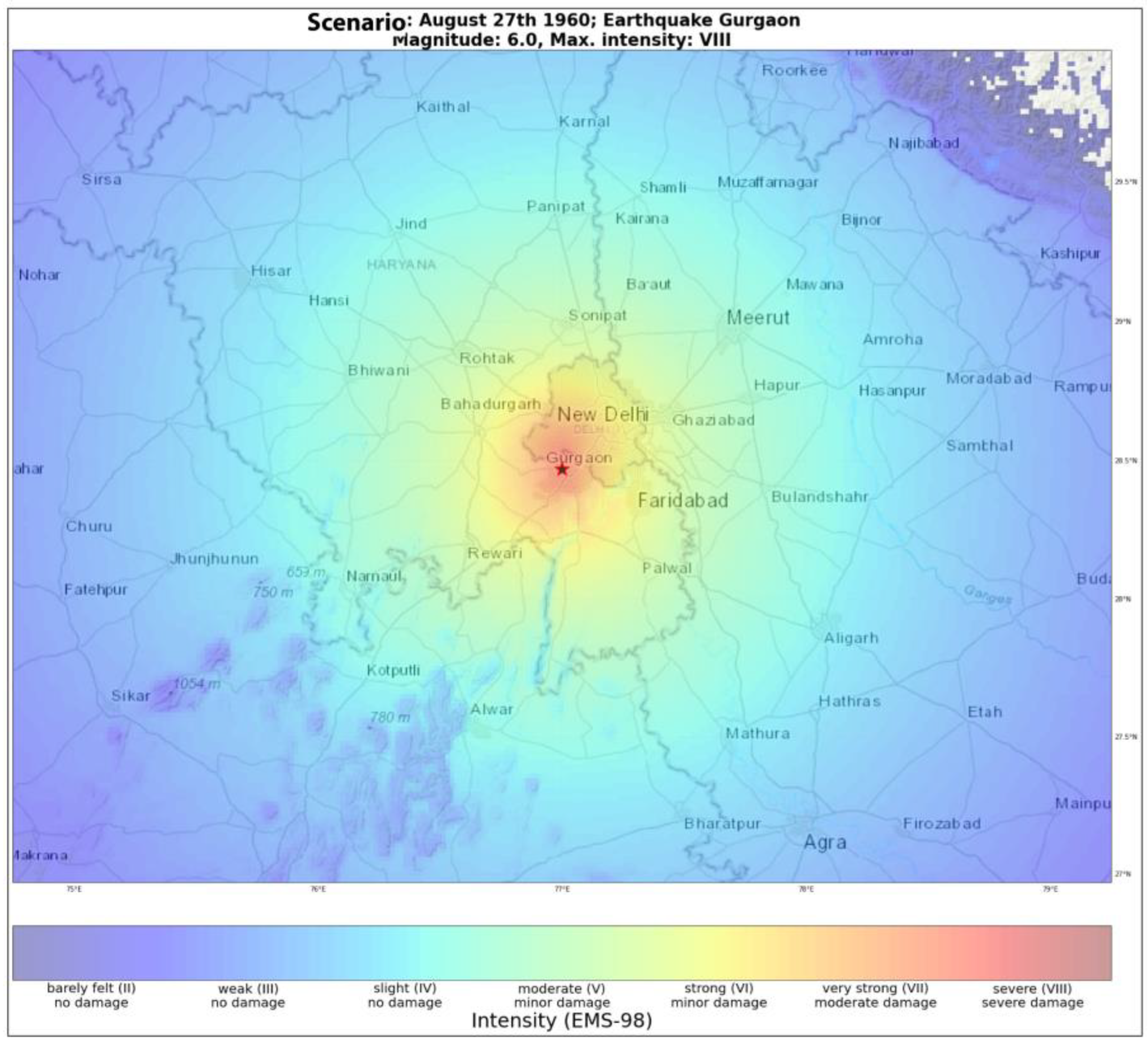
| 27 August 1960 | 28.20° N–77.40° E | Mw = 6.0 | VII | Near Faridabad | Cracks in buildings, old houses collapsed |
| 15 August 1966 | 28.67° N–78.93° E | Mw = 5.8 | V | Near Moradabad | Moderate shaking around Delhi |
| 5 March 2012 | 28.74° N–76.60° E | Mw = 5.0 | VI | Delhi | Cracks in buildings |
2. Geology and Tectonics of the Study Area
3. Methodology
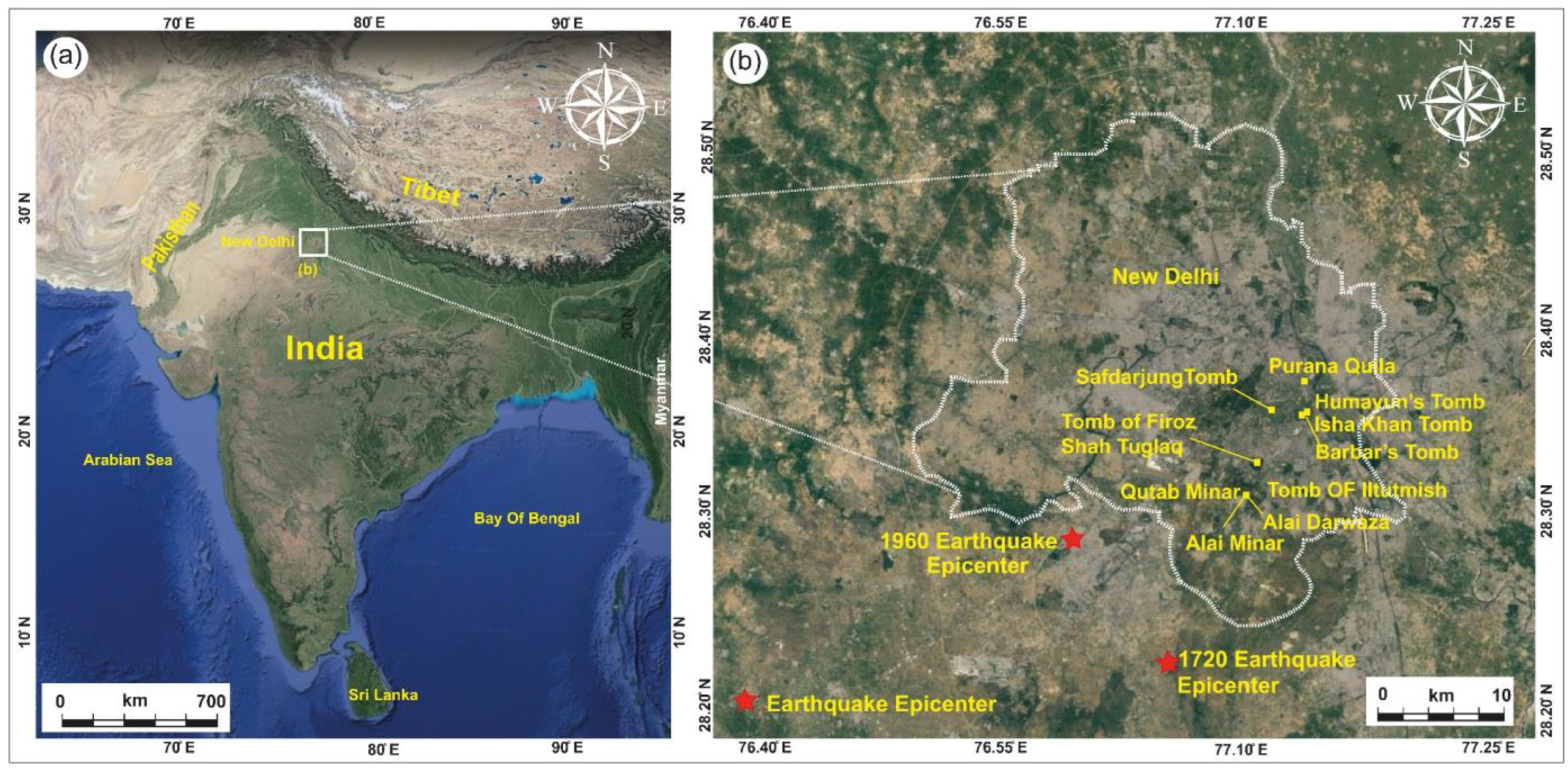
4. Past Damaging Earthquakes around Delhi
4.1. The 6 June 1505 CE Earthquake
4.2. The 26 July 1720 CE Earthquake
4.3. The 1 September 1803 CE Earthquake
4.4. Recent Earthquakes
5. Archeoseismological Evidence from Delhi
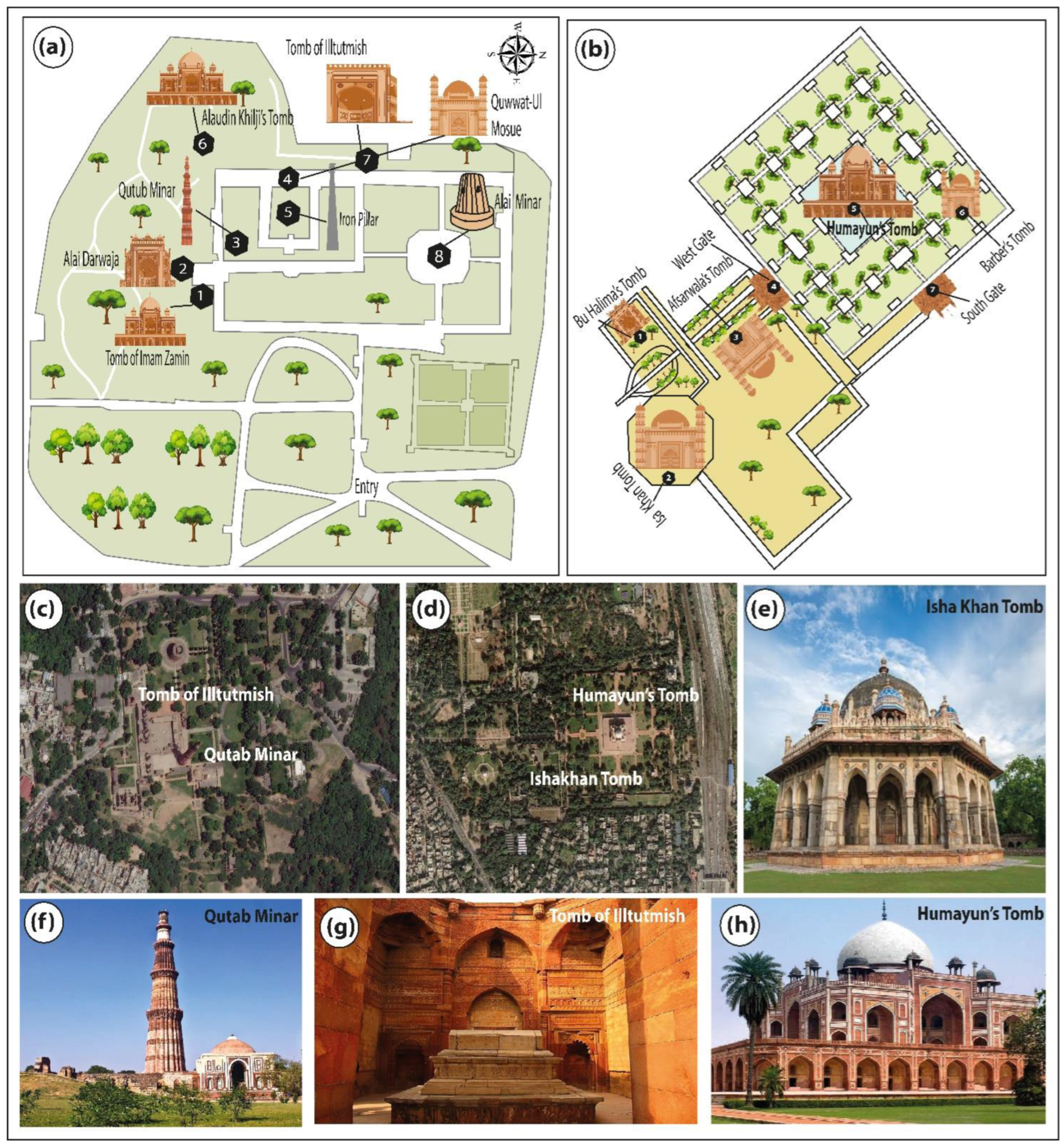
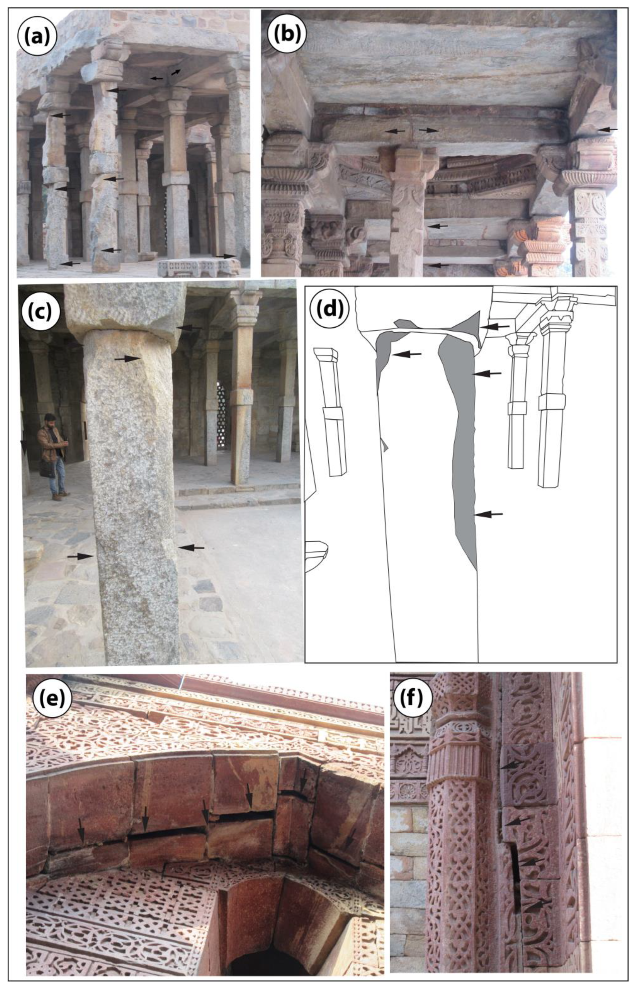
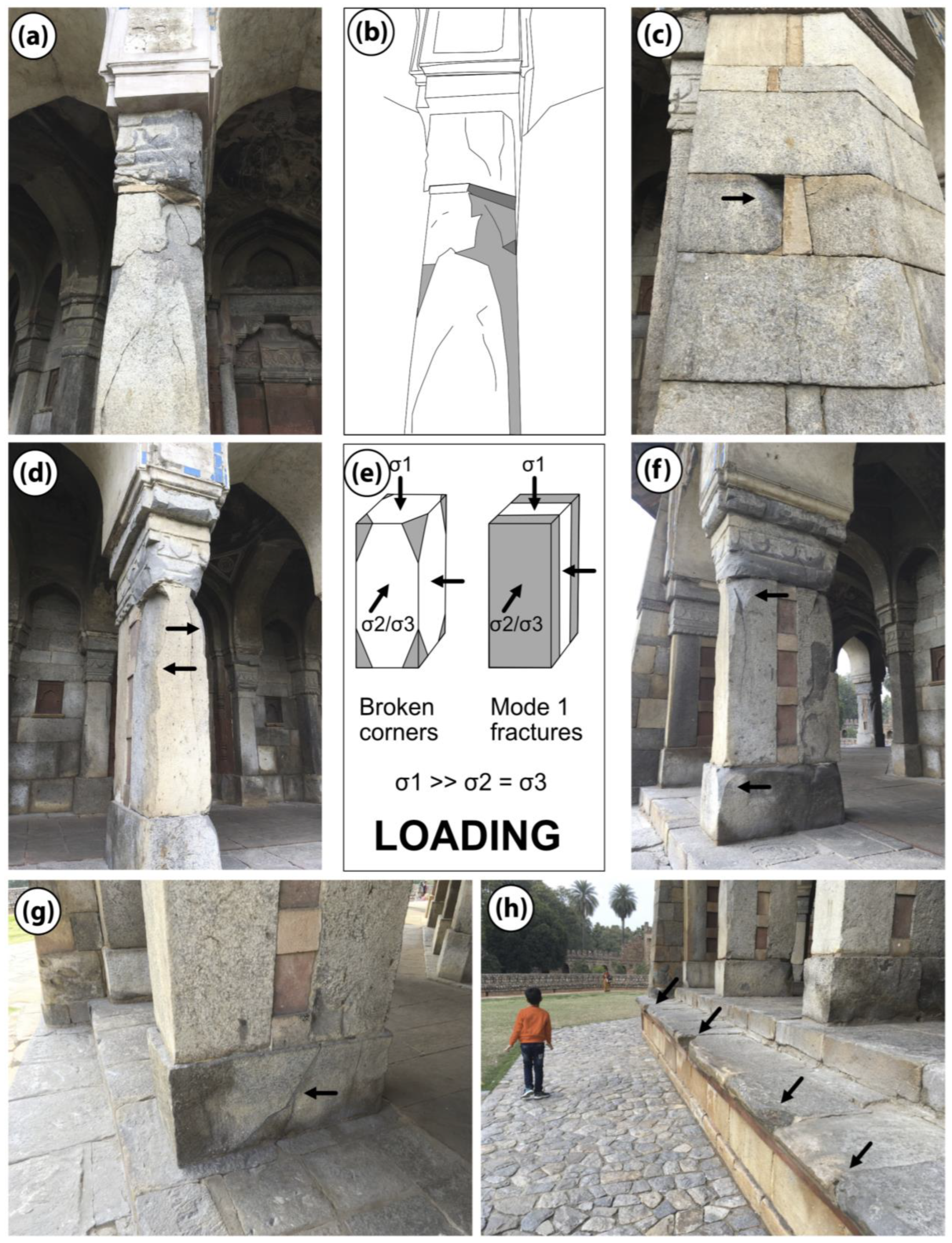
5.1. The Qutab Minar Complex
5.2. Iltutmish’s Tomb
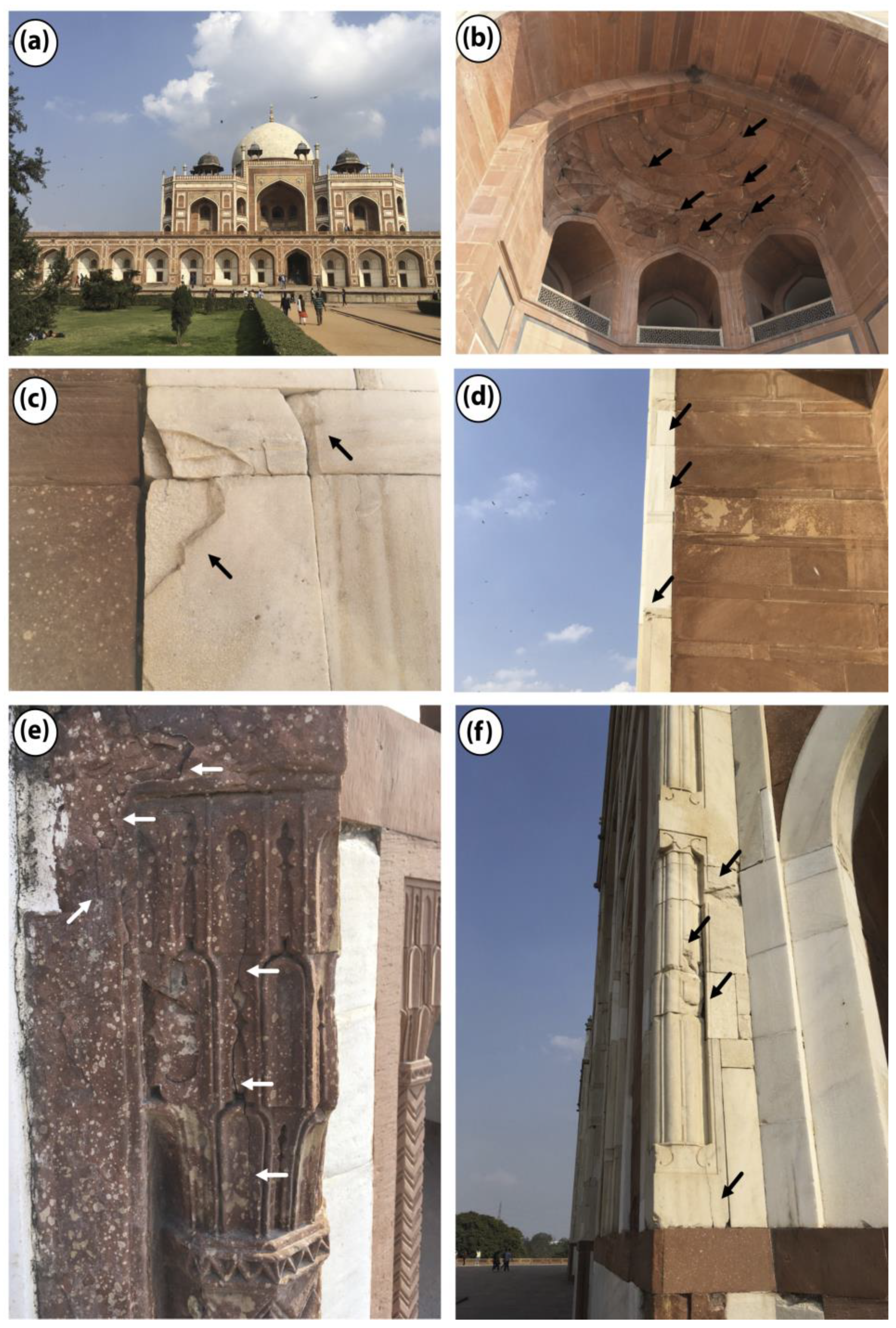
5.3. Humayun’s Tomb
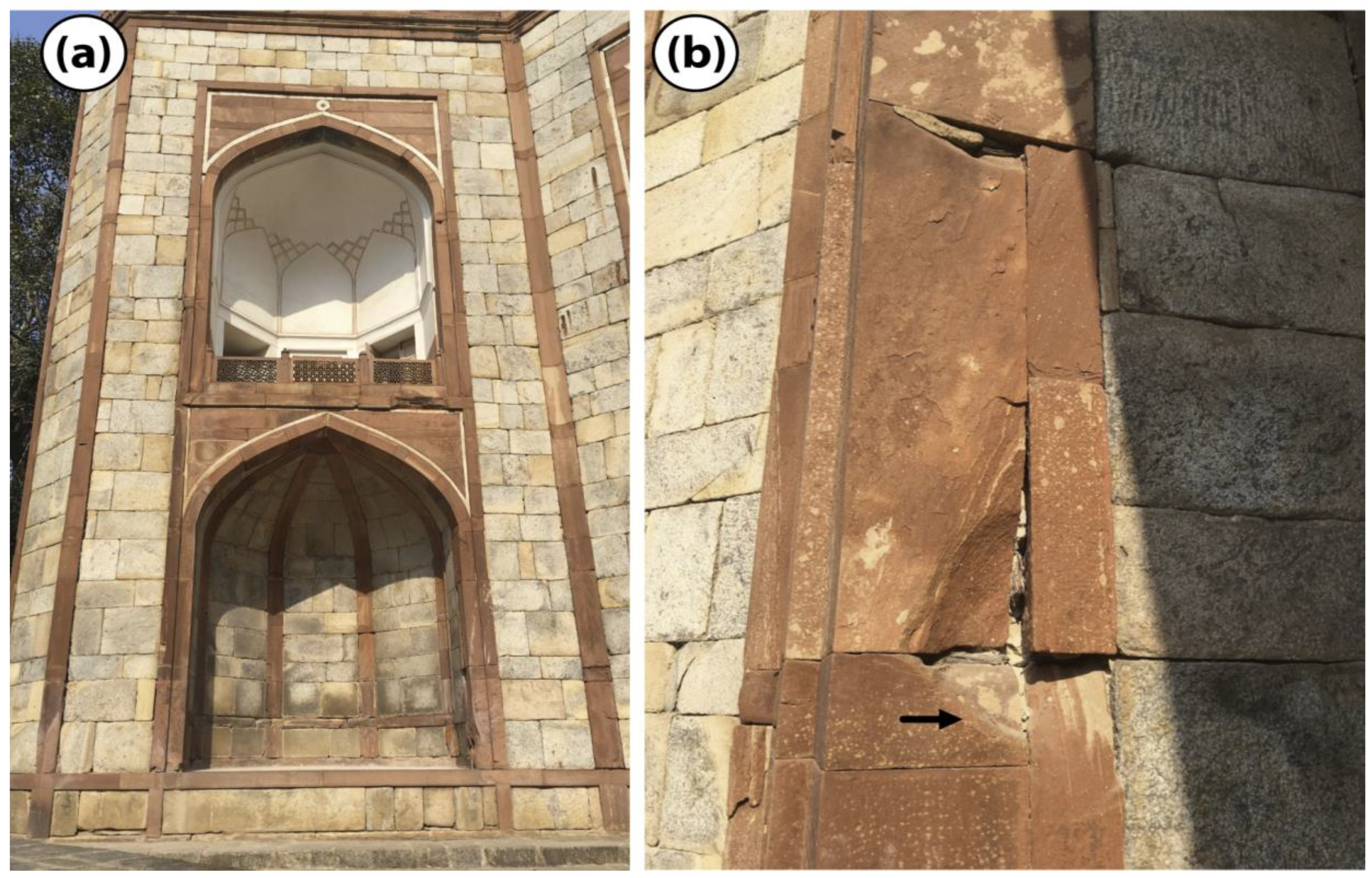
5.4. Isa Khan’s Tomb
6. Generation of Paleo ShakeMaps and Its Implication for the Archeoseismic Damage Observed
7. Discussion
8. Conclusions
Author Contributions
Funding
Data Availability Statement
Conflicts of Interest
References
- Guidoboni, E.; Stucchi, M. The contribution of historical records of earthquakes to the evaluation of seismic hazard. Ann. Geofi. 1993, 36, 201–215. [Google Scholar] [CrossRef]
- Bilham, R.; Gaur, V.K.; Molnar, P. Himalayan Seismic Hazard. Science 2001, 293, 1442–1444. [Google Scholar] [CrossRef] [PubMed]
- Galadini, F.; Hinzen, K.G.; Stiros, S. Archaeoseismology: Methodological issues and procedure. J. Seismol. 2006, 10, 395–414. [Google Scholar] [CrossRef]
- Silva, P.G.; Sintubin, M.; Reicherter, K. New advances in studies of earthquake archaeology and palaeoseismology. Quat. Int. 2011, 242, 1–3. [Google Scholar] [CrossRef]
- Sintubin, M. Archaeoseismology: Past, present and future. Quat. Int. 2011, 242, 4–10. [Google Scholar] [CrossRef]
- Jusseret, S. Earthquake archaeology. J. Contemp. Archaeol. 2014, 1, 277–296. [Google Scholar] [CrossRef]
- Benjelloun, Y.; de Sigoyer, J.; Dessales, H.; Baillet, L.; Guéguen, P.; Sahin, M. Historical earthquake scenarios for the middle strand of the North Anatolian Fault deduced from archeo-damage inventory and building deformation modeling. Seismol. Soc. Am. 2021, 92, 583–598. [Google Scholar] [CrossRef]
- Martín-González, F.; Crespo-Martín, C.; Cesca, S.; González-Muñoz, S. Understanding seismicity and seismotectonics in a stable continental region (NW Iberian Peninsula): Implications for the nature of intraplate seismicity. Global Planet. Change 2023, 227, 104177. [Google Scholar] [CrossRef]
- Stiros, S.C. Identification of earthquakes from archaeological data: Methodology, criteria and limitations. Archaeoseismology 1996, 7, 129–152. [Google Scholar]
- Ambraseys, N. The seismic activity of the Marmara Sea region over the last 2000 years. Bull. Seismol. Soc. Am. 2002, 92, 1–18. [Google Scholar] [CrossRef]
- Ambraseys, N.N. Earthquakes and archaeology. J. Archaeol. Sci. 2006, 33, 1008–1016. [Google Scholar] [CrossRef]
- McCalpin, J.P.; Nelson, A.R. Introduction to paleoseismology. Int. Geophy. 1996, 62, 1–32. [Google Scholar]
- Hinzen, K.G.; Fleischer, C.; Reamer, S.K.; Schreiber, S.; Schütte, S.; Yerli, B. Quantitative methods in archaeoseismology. Quat. Int. 2011, 242, 31–41. [Google Scholar] [CrossRef]
- Rodríguez-Pascua, M.A.; Pérez-López, R.; Giner-Robles, J.L.; Silva, P.G.; Garduño-Monroy, V.H.; Reicherter, K. A comprehensive classification of Earthquake Archaeological Effects (EAE) in archaeoseismo logy: Application to ancient remains of Roman and Mesoamerican cultures. Quat. Int. 2011, 242, 20–30. [Google Scholar]
- Martín-González, F. Earthquake damage orientation to infer seismic parameters in archaeological sites and historical earthquakes. Tectonophysics 2018, 724, 137–145. [Google Scholar] [CrossRef]
- Jusseret, S.; Langohr, C.; Sintubin, M. A new methodology for the critical assessment of earthquake-related damage in archaeological contexts/a proof of concept for the 13th century BC in Minoan Crete (Late Minoan IIIB). In Proceedings of the Seismic Hazard, Critical Facilities and Slow Active Faults, 4th International INQUA Meeting on Paleoseismology, Active Tectonics and Archeoseismology (PATA), Aachen, Germany, 9–14 October 2013; pp. 109–112. [Google Scholar]
- Kázmér, M.; Roy, A.B.; Prizomwala, S. Archaeoseismological potential of the Indian subcontinent. Cur. Sci. 2020, 119, 1767. [Google Scholar] [CrossRef]
- Combey, A.; Tricoche, A.; Audin, L.; Gandreau, D.; Escóbar, C.B.; Abuhadba, J.B.; Tavera, H.; Rodríguez-Pascua, M.Á. Monumental Inca remains and past seismic disasters: A relational database to support archaeoseismological investigations and cultural heritage preservation in the Andes. J. S. Am. Earth Sci. 2021, 111, 103447. [Google Scholar] [CrossRef]
- Noller, J.S. Archaeoseismology: Shaking out the history of humans and earthquakes. Earth Sci. Archaeol. 2001, 10, 143–170. [Google Scholar] [CrossRef]
- Satuluri, S.; Gadhavi, M.S.; Malik, J.N.; Vikrama, B. Quantifying seismic induced damage at ancient site Manjal located in Kachchh Mainland region of Gujarat, India. J. Archaeol. Sci. Rep. 2020, 33, 102486. [Google Scholar] [CrossRef]
- Bansal, B.K.; Mohan, K.; Ul Haq, A.; Verma, M.; Prajapati, S.K.; Bhat, G.M. Delineation of the causative fault of recent earthquakes (April–May 2020) in Delhi from seismological and morphometric analysis. J. Geol. Soc. India 2021, 97, 451–456. [Google Scholar] [CrossRef]
- Gupta, H.; Narain, H.; Rastogi, B.K.; Mohan, I. A study of the Koyna earthquake of December 10, 1967. Bull. Seismol. Soc. Am. 1969, 59, 1149–1162. [Google Scholar] [CrossRef]
- Schweig, E.; Gomberg, J.; Petersen, M.; Ellis, M.; Bodin, P.; Mayrose, L.; Rastogi, B.K. The Mw 7.7 Bhuj earthquake: Global lessons for earthquake hazard in intra-plate regions. Geol. Soc. India 2003, 61, 277–282. [Google Scholar]
- Gupta, H.K. Reservoir-Induced Earthquakes; Elsevier: Amsterdam, The Netherlands, 1992; ISBN 9780444597359. [Google Scholar]
- Jain, S.K. Implications of 2001 Bhuj earthquake for seismic risk reduction in India. In Proceedings of the 13th World Conference on Earthquake Engineering (13WCEE), Vancouver, BC, Canada, 1–6 August 2004. Paper No. 3244. [Google Scholar]
- Choudhury, P.; Chopra, S.; Kumar, M.R. A review of seismic hazard assessment of Gujarat: A highly active intra-plate region. Earth Sci. Rev. 2018, 187, 205–218. [Google Scholar] [CrossRef]
- Booth, E.; Vasavada, R. Effect of the Bhuj, India Earthquake of 26 January 2001 on Heritage Buildings. Architecture 2001. Available online: www.booth-seismic.co.uk/Gujarat%20Intach%20report.pdf (accessed on 1 December 2023).
- Gupta, H.; Gahalaut, V.K. Seismotectonics and large earthquake generation in the Himalayan region. Gondwana Res. 2014, 25, 204–213. [Google Scholar] [CrossRef]
- Bilham, R. Himalayan earthquakes: A review of historical seismicity and early 21st century slip potential. Geol. Soc. Lond. Spec. Pub. 2019, 483, 423–482. [Google Scholar] [CrossRef]
- Oldham, T. A catalog of Indian earthquakes. Mem. Geolog. Sur. India 1883, 19, 163–215. [Google Scholar]
- Tandon, A.N.; Srivastava, H.N. Focal mechanisms of some recent Himalayan earthquakes and regional plate tectonics. Bull. Seismol. Soc. Am. 1975, 65, 963–969. [Google Scholar] [CrossRef]
- Iyengar, R.N.; Sharma, D.; Siddiqui, J.M. Earthquake history of India in medieval times. India J. Hist. Sci. 1999, 34, 181–238. [Google Scholar]
- Sharma, V.D. Delhi and Its Neighbourhood; Archaeological Survey of India: New Delhi, India, 2001; p. 161. [Google Scholar]
- Rajendran, C.P.; Rajendran, K. The status of central seismic gap: A perspective based on the spatial and temporal aspects of the large Himalayan earthquakes. Tectonophysics 2005, 395, 19–39. [Google Scholar] [CrossRef]
- Martin, S.; Szeliga, W. A catalog of felt intensity data for 570 earthquakes in India from 1636 to 2009. Bull. Seismol. Soc. Am. 2010, 100, 562–569. [Google Scholar] [CrossRef]
- Prakash, R.; Shrivastava, J.P. A review of the seismicity and seismotectonics of Delhi and adjoining areas. J. Geolog. Soc. India 2012, 79, 603–617. [Google Scholar] [CrossRef]
- Malik, J.N.; Naik, S.P.; Sahoo, S.; Okumura, K.; Mohanty, A. Paleoseismic evidence of the CE 1505 (?) and CE 1803 earthquakes from the foothill zone of the Kumaon Himalaya along the Himalayan Frontal Thrust (HFT), India. Tectonophysics 2017, 714, 133–145. [Google Scholar] [CrossRef]
- Tandon, A.N. The very great earthquake of August 15 1950. In A Compilation of Papers on the Assam Earthquake of August 15, 1950; Rao, M.B.R., Ed.; Pub. 1; Central Board of Geophysics, Government of India: New Delhi, India, 1953; pp. 80–89. [Google Scholar]
- Srivastava, L.S.; Somayajulu, J.G. The seismicity of area around Delhi. In Proceedings of the III Symposium on Earthquake Engineering, University of Roorkee, Roorkee, India, 4–6 November 1966; pp. 417–422. [Google Scholar]
- Srivastava, A.K.; Jalote, P.M. Seismicity and tectonic set up of the area around Delhi. In Proceedings of the Sixth World Conference on Earthquake Engineering, New Delhi, India, 10–14 January 1977; pp. 791–798. [Google Scholar]
- Srivastava, V.K.; Roy, A.K. Proceedings of the IV Congress. Int. Assoc. Eng. Geol. 1982, VIII, 77–78. [Google Scholar]
- Iyengar, R.N. Seismic status of Delhi megacity. Cur. Sci. 2000, 78, 568–574. [Google Scholar]
- Iyengar, R.N.; Ghosh, S. Microzonation of earthquake hazard in greater Delhi area. Cur. Sci. 2004, 87, 1193–1202. [Google Scholar]
- Bansal, B.K.; Verma, M. The M 4.9 Delhi earthquake of 5 march 2012. Cur. Sci. 2012, 102, 1704–1708. [Google Scholar]
- Sharma, M.L.; Wason, H.R. Estimation of seismic hazard and seismic zonation at bed rock level for Delhi region, India. In Proceedings of the 13th World Conference on Earthquake Engineering, Vancouver, BC, Canada, 1–6 August 2004. [Google Scholar]
- Mittal, H.; Sharma, B.; Ammani, A. Characteristics of earthquake ground motions governing the damage potential for Delhi and the surrounding region of India. Quat. Sci. Adv. 2023, 2, 100098. [Google Scholar] [CrossRef]
- Yadav, R.K.; Martin, S.S.; Gahalaut, V.K. Intraplate seismicity and earthquake hazard in the Aravalli–Delhi Fold Belt, India. J. Earth Syst. Sci. 2022, 131, 204. [Google Scholar] [CrossRef]
- Singh, S.K.; Suresh, G.; Dattatrayam, R.S.; Shukla, H.P.; Martin, S.; Havskov, J.; Perez-Campos, X.; Iglesias, A. The Delhi 1960 earthquake: Epicentre, depth and magnitude. Curr. Sci. 2013, 105, 1155–1165. [Google Scholar]
- Michetti, A.M.; Marco, S. Future trends in paleoseismology: Integrated study of the seismic landscape as a vital tool in seismic hazard analyses. Tectonophysics 2005, 408, 3–21. [Google Scholar] [CrossRef]
- Karakhanian, A.S.; Trifonov, V.G.; Ivanova, T.P.; Avagyan, A.; Rukieh, M.; Minini, H.; Dodonov, A.E.; Bachma-nov, D.M. Seismic deformation in the St. Simeon Monasteries (Qal’at Sim’an), Northwestern Syria. Tectonophysics 2008, 453, 122–147. [Google Scholar] [CrossRef]
- Berberian, M.; Shahmirzādi, S.M.; Djamali, M. Archeoseismicity and environmental crises at the Sialk mounds, Central Iranian plateau, since the Early Neolithic. J. Archaeol. Sci. 2012, 39, 2845–2858. [Google Scholar] [CrossRef]
- Udías, A. Historical earthquakes (before 1755) of the Iberian Peninsula in early catalogs. Seismol. Res. Let. 2015, 86, 999–1005. [Google Scholar] [CrossRef]
- Marco, S. Recognition of earthquake-related damage in archaeological sites: Examples from the Dead Sea fault zone. Tectonophysics 2008, 453, 148–156. [Google Scholar] [CrossRef]
- Martín-González, F.; Antón, L.; Insua Arévalo, M.; Vicente, G.D.; Martínez-Díaz, J.J.; Muñoz-Martín, A.; Heredia, N.; Olaiz, A. Seismicity and potentially active faults in the Northwest and Central-West Iberian Peninsula. J. Iberian Geol. 2012, 38, 52–69. [Google Scholar]
- Mackey, B.H.; Quigley, M.C. Strong proximal earthquakes revealed by cosmogenic 3He dating of prehistoric rockfalls, Christchurch, New Zealand. Geology 2014, 42, 975–978. [Google Scholar] [CrossRef]
- Jin, K.; Lee, M.; Kim, Y.S.; Choi, J.H. Archaeoseismological studies on historical heritage sites in the Gyeongju area, SE Korea. Quat. Int. 2011, 242, 158–170. [Google Scholar] [CrossRef]
- Reicherter, K.; Michetti, A.M.; Barroso, P.S. Paleoseismology: Historical and prehistorical records of earthquake ground effects for seismic hazard assessment. Geol. Soc. Lond. Spec. Publ. 2009, 316, 1–10. [Google Scholar] [CrossRef]
- Kázmér, M.; Major, B. Sāfitā castle and rockfalls in the ‘dead villages’ of coastal Syria—An archaeoseismological study. Compt. Rend. Geosc. 2015, 347, 181–190. [Google Scholar] [CrossRef]
- Forlin, P.; Valente, R.; Kázmér, M. Assessing earthquake effects on archaeological sites using photogrammetry and 3D model analysis. Dig. Appl. Archaeol. Cult. Herit. 2018, 9, e00073. [Google Scholar] [CrossRef]
- Sintubin, M.; Stewart, I.S. A logical methodology for archaeoseismology: A proof of concept at the archaeological site of Sagalassos, southwest Turkey. Bull. Seismol. Soc. Am. 2008, 98, 2209–2230. [Google Scholar] [CrossRef]
- Kázmér, M. An Unknown Destructive Earthquake in Transylvania in the 1660s–Archeoseismology of the Inlăceni Unitarian Church (Harghita County, Romania). Rom. J. Phy. 2021, 66, 804. [Google Scholar]
- Audin, L.; Avouac, J.P.; Flouzat, M.; Plantet, J.L. Fluid-driven seismicity in a stable tectonic context: The Remiremont fault zone, Vosges, France. Geophys. Res. Let. 2002, 29, 13-1–13-4. [Google Scholar] [CrossRef]
- Korjenkov, A.; Baipakov, K.; Chang, C.; Peshkov, Y.; Savelieva, T. Traces of ancient earthquakes in medieval cities along the Silk Road, northern Tien Shan and Dzhungaria. Turk. J. Earth Sci. 2003, 12, 241–261. [Google Scholar]
- Korjenkov, A.M.; Mazor, E. The features of the earthquake damage patterns of ancient city ruins in the Negev Desert, Israel. Geotect 2013, 47, 52–65. [Google Scholar] [CrossRef]
- Hinzen, K.G.; Schwellenbach, I.; Schweppe, G.; Marco, S. Quantifying earthquake effects on ancient arches, example: The Kalat Nimrod Fortress, Dead Sea fault zone. Seismol. Res. Let. 2016, 87, 751–764. [Google Scholar] [CrossRef]
- Martín-González, F. Review and proposed method to study the damage orientation of earthquake effects in pre-instrumental earthquakes. Izv. Phy. Sol. Earth 2021, 57, 980–993. [Google Scholar] [CrossRef]
- Kim, Y.S.; Naik, S.P.; Choi, J.H.; Jin, K.; Ho, G.R.; Kim, T.; Lee, J. Kinematic analysis and fault-dependence of building-wall fracture patterns during moderate earthquakes. Geosc. J. 2023, 27, 769–780. [Google Scholar] [CrossRef]
- Kázmér, M.; Major, B. Distinguishing damages of two earthquakes—Archeoseismology of a Crusader castle (Al-Marqab citadel, Syria). Geol. Soc. Am. 2010, 471, 186–199. [Google Scholar]
- Kovach, R.L.; Grijalva, K.; Nur, A. Earthquakes and civilizations of the Indus valley: A challenge for archaeoseismology. Geol. Soc. Am. 2010, 471, 119–127. [Google Scholar]
- Rajendran, C.P. Deformational features in the river bluffs at Ter, Osmanabad district, Maharashtra: Evidence for an ancient earthquake. Cur. Sci. 1997, 72, 750–755. [Google Scholar]
- Bilham, R.; Bali, B.S.; Bhat, M.I.; Hough, S. Historical earthquakes in Srinagar, Kashmir: Clues from the Shiva temple at Pandrethan. Geolog. Soc. Am. 2010, 471, 107–117. [Google Scholar]
- Sana, H.; Bhat, F.A.; Sana, S. The ancient temples of Kashmir turned from marvel to ruin by earthquakes? A case study of the Pattan twin temples (AD 883–902). Seismol. Res. Lett. 2019, 90, 358–365. [Google Scholar] [CrossRef]
- Joshi, M.; Thakur, V.C. Signatures of 1905 Kangra and 1555 Kashmir earthquakes in medieval period temples of Chamba region, northwest Himalaya. Seismol. Res. Lett. 2016, 87, 1150–1160. [Google Scholar] [CrossRef]
- Rajendran, C.P.; Rajendran, K.; Sanwal, J.; Sandiford, M. Archeological and historical database on the medieval earthquakes of the central Himalaya: Ambiguities and inferences. Seismol. Res. Let. 2013, 84, 1098–1108. [Google Scholar] [CrossRef]
- Anthony, W.; Howard, C. The Tughluqs: Master Builders of the Delhi Sultanate. Muqarnas 1983, 1, 123–166. [Google Scholar]
- Javeed, T. World Heritage Monuments and Related Edifices in India; Algora Publishing: New York, NY, USA, 2008; Volume 2, p. 10128. ISBN 0875864848/9780875864846. [Google Scholar]
- Dadlani, C. Histories of Ornament: From Global to Local; Bacci, M., Ed.; Princeton University Press: Princeton, NJ, USA, 2016; pp. 179–180. ISBN 9780691167282. [Google Scholar]
- Chouhan, R.K.S.; Srivastava, V.K. Focal mechanisms in northeastern India and their tectonic implications. Pur. Appl. Geophy. 1975, 113, 467–482. [Google Scholar] [CrossRef]
- Dasgupta, S.; Narula, P.L.; Acharyya, S.K.; Banerjee, J. Seismotectonic Atlas of India and Its Environs; Geological Survey of India: Kolkata, India, 2000; ISBN 02540436. [Google Scholar]
- Khan, P.K.; Mohanty, S.P.; Chakraborty, P.P.; Singh, R. Earthquake shocks around Delhi-NCR and the adjoining Himalayan front: A seismotectonic perspective. Front. Earth Sci. 2021, 9, 598784. [Google Scholar] [CrossRef]
- Heron, A.M. Geology of central and southern Rajputana. Mem. Geol. Sur. India 1953, 79, 389. [Google Scholar]
- Gupta, S.N.; Arora, Y.K.; Mathur, R.K.; Iqbaluddin, B.P.; Sahai, T.N.; Sharma, S.B.; Murthy, M.V.N. Lithostratigraphic Map of Aravalli Region, Southern Rajasthan and Northeastern Gujarat; Geological Survey of India: Hyderabad, India, 1980. [Google Scholar]
- Sugden, T.J.; Deb, M.; Windley, B.F. The tectonic setting of mineralisation in the Proterozoic Aravalli Delhi Orogenic belt, NW India. In Developments in Precambrian Geology; Elsevier: Amsterdam, The Netherlands, 1990; Volume 8, pp. 367–390. [Google Scholar]
- Sinha-Roy, S. Stratigraphic and tectonic controls of gold mineralization in the Aravalli fold belt, Banswara district, Rajasthan. In Proceedings of the Preworkshop Volume of National Workshop on Exploration and Exploitation of Gold Resources of India, Hyderabad, India, 2–4 December 1966; pp. 158–159. [Google Scholar]
- Rao, V.V.; Prasad, B.R.; Reddy, P.R.; Tewari, H.C. Evolution of Proterozoic Aravalli Delhi fold belt in the northwestern Indian shield from seismic studies. Tectonophysics 2000, 327, 109–130. [Google Scholar]
- Sengupta, S. Possible subsurface structures below the Himalayas and the Gangetic Plains. In Proceedings of the Section 11, Himalayan and Alpine Orogeny, 22nd International Geological Congress, New Delhi, India, 14–22 December 1964; pp. 334–352. [Google Scholar]
- Karunakaran, C.; Ranga Rao, A. Status of exploration for hydrocarbons in the Himalayan region—Contributions to stratigraphy and structure. Geol. Sur. Inia Mis. Pub. 1976, 41, 1–66. [Google Scholar]
- Patel, N.K.; Pati, P.; Verma, A.K.; Dash, C.; Gupta, A.; Sharma, V. Seismicity around the Mahendragarh–Dehradun basement fault in the western Ganga plain, India: A neotectonic perspective. Int. J. Earth Sci. 2020, 109, 689–706. [Google Scholar] [CrossRef]
- Bansal, B.K.; Mohan, K.; Verma, M.; Sutar, A.K. A holistic seismotectonic model of Delhi region. Sci. Rep. 2021, 11, 13818. [Google Scholar] [CrossRef] [PubMed]
- Dhali, M.; Gadhavi, M.S.; Mohan, K.; Narayana, P.P.; Malik, J.N. Active faults studies in Delhi and national capital region (NCR): Inferences from satellite data and field investigations. Front. Earth Sci. 2023, 11, 1092927. [Google Scholar] [CrossRef]
- Verma, M.; Singh, R.J.; Bansal, B.K. Soft sediments and damage pattern: A few case studies from large Indian earthquakes vis-a-vis seismic risk evaluation. Nat. Haz. 2014, 74, 1829–1851. [Google Scholar] [CrossRef]
- Sastri, V.V.; Bhandari, L.L.; Raju, A.T.R.; Datta, A.K. Tectonic framework and subsurface stratigraphy of the Ganga basin. Geolog. Soc. India 1971, 12, 222–233. [Google Scholar]
- Dubey, C.S.; Shukla, D.P.; Singh, R.P.; Sharma, M.; Ningthoujam, P.S.; Bhola, A.M. Present activity and seismogenic potential of Himalayan sub-parallel thrust faults in Delhi: Inferences from remote sensing, GPR, gravity data and seismicity. Near Surf. Geophys. 2012, 10, 369–380. [Google Scholar] [CrossRef]
- Jade, S.; Shrungeshwara, T.S.; Kumar, K.; Choudhury, P.; Dumka, R.K.; Bhu, H. India plate angular velocity and contemporary deformation rates from continuous GPS measurements from 1996 to 2015. Scientific Rep. 2017, 7, 11439. [Google Scholar] [CrossRef]
- Heidbach, O.; Rajabi, M.; Cui, X.; Fuchs, K.; Müller, B.; Reinecker, J.; Reiter, K.; Tingay, M.; Wenzel, F.; Xie, F.; et al. The World Stress Map database release 2016: Crustal stress pattern across scales. Tectonophysics 2018, 744, 484–498. [Google Scholar] [CrossRef]
- Wang, F.; Miyajima, M.; Dahal, R.; Timilsina, M.; Li, T.; Fujiu, M.; Kuwada, Y.; Zhao, Q. Effects of topographic and geological features on building damage caused by 2015.4. 25 Mw7. 8 Gorkha earthquake in Nepal: A preliminary investigation report. Geoenv. Disast. 2016, 3, 7. [Google Scholar] [CrossRef]
- Meghraoui, M.; Hinzen, K.G.; Malik, J. Paleoseismology, archeoseismology and paleotsunami studies. In Encyclopedia of Geology; Elsevier: Amsterdam, The Netherlands, 2021; pp. 636–655. [Google Scholar]
- Kázmér, M.; Gaidzik, K.; Al-Tawalbeh, M.; Steinritz, V.; Reicherter, K.; Hoffmann, G. Seismic catastrophes in historical times in Arabia–Destruction of the city of Qalhat (Oman) in the 16th century. Quat. Int. 2023, 664, 42–58. [Google Scholar] [CrossRef]
- Oliveti, I.; Faenza, L.; Michelini, A. New reversible relationships between ground motion parameters and macroseismic intensity for Italy and their application in ShakeMap. Geophys. J. Int. 2022, 231, 1117–1137. [Google Scholar] [CrossRef]
- Mittal, H.; Wu, Y.M.; Lin, T.L.; Legendre, C.P.; Gupta, S.; Yang, B.M. Time-dependent shake map for Uttarakhand Himalayas, India, using recorded earthquakes. Acta Geophys. 2019, 67, 753–763. [Google Scholar] [CrossRef]
- Worden, C.B.; Thompson, E.M.; Hearne, M.; Wald, D.J. ShakeMap Manual Online: Technical manual, user’s guide, and software guide. U.S. Geol. Survey. 2020. Available online: http://cbworden.github.io/shakemap/ (accessed on 1 December 2023).
- Wu, Y.M.; Mittal, H.; Huang, T.C.; Yang, B.M.; Jan, J.C.; Chen, S.K. Performance of a low-cost earthquake early warning system (P-Alert) and shake map production during the 2018 Mw 6.4 Hualien, Taiwan, earthquake. Seismol. Res. Lett. 2019, 90, 19–29. [Google Scholar] [CrossRef]
- Rizza, M.; Bollinger, L.; Sapkota, S.N.; Tapponnier, P.; Klinger, Y.; Karakaş, Ç.; Kali, E.; Etchebes, M.; Tiwari, D.R.; Siwakoti, I.; et al. Post-earthquake aggradation processes to hide surface ruptures in thrust systems: The M8. 3, 1934, Bihar-Nepal earthquake ruptures at Charnath Khola (Eastern Nepal). J. Geophys. Res. Solid Earth 2019, 124, 9182–9207. [Google Scholar] [CrossRef]
- Ambraseys, N.; Jackson, D. A note on early earthquakes in northern India and southern Tibet. Cur. Sci. 2003, 84, 570–582. [Google Scholar]
- Quittmeyer, R.C.; Jacob, K.H. Historical and modern seismicity of Pakistan, Afghanistan, northwestern India, and southeastern Iran. Bull. Seismol. Soc. Am. 1979, 69, 773–823. [Google Scholar]
- Munshi, R.N. The History of the Kutb Minar, Bombay; Asian Educational Services: New Delhi, India, 1911; p. 94. [Google Scholar]
- Bapat, A.; Kulkarni, R.C.; Guha, S.K. Catalog of Earthquakes in India and Neighborhoods from the Historical Period up to 1979; Indian Society of Earthquake Technology: Roorkee, India, 1983; p. 211. [Google Scholar]
- Ambraseys, N.N.; Douglas, J. Magnitude calibration of north Indian earthquakes. Geophys. J. Int. 2004, 159, 165–206. [Google Scholar] [CrossRef]
- Mugnier, J.L.; Gajurel, A.; Huyghe, P.; Jayangondaperumal, R.; Jouanne, F.; Upreti, B. Structural interpretation of the great earthquakes of the last millennium in the Central Himalayas. Earth Sci. Rev. 2013, 127, 30–47. [Google Scholar] [CrossRef]
- Dasgupta, S.; Mukhopadhyay, B. 1803 earthquake in Garhwal Himalaya–Archival materials with commentary. Ind. J. Hist. Sci. 2014, 49, 21–33. [Google Scholar]
- Freymueller, J.; Bilham, R.; Bürgmann, R.; Larson, K.M.; Paul, J.; Jade, S.; Gaur, V. Global positioning system measurements of Indian plate motion and convergence across the Lesser Himalaya. Geophys. Res. Let. 1996, 23, 3107–3110. [Google Scholar] [CrossRef]
- Gattulli, V.; Antonacci, E.; Vestroni, F. Field observations and failure analysis of the Basilica S. Maria di Collemaggio after the 2009 L’Aquila earthquake. Eng. Fail. Anal. 2013, 34, 715–734. [Google Scholar] [CrossRef]
- Kázmér, M. Repeated historical earthquakes in Sousse, Monastir and El-Jem (Tunisia)—An archaeoseismological study. Arab. J. Geosc. 2021, 14, 214. [Google Scholar] [CrossRef]
- Rideaud, A. Pathologies: Quelques reperes visuels. Eclats conchoides. In Archéosismicité Vulnérabilité. Patrimoine Bâti et Société; Levret, A., Ed.; Actes des VIe et VIIe Rencontres du Groupe APS; Groupe APS: Perpignan, France, 2008; p. 140. [Google Scholar]
- Rideaud, A.; Helly, B. Ancient buildings and seismic cultures: The cases in Armenia. In Proceedings of the 42nd International Commission on the History of Geological Sciences (INHIGEO) Symposium, Yerevan, Armenia, 12–18 September 2017; Abstracts and Guidebook, 2017; p. 139. [Google Scholar]
- Pampanin, S. Controversial aspects in seismic assessment and retrofit of structures in modern times: Understanding and implementing lessons from ancient heritage. Bull. N. Z. Soc. Earthq. Eng. 2006, 39, 120–133. [Google Scholar] [CrossRef]
- Al-Tawalbeh, M. Earthquake-Related Damage at Two Sites East of the Dead Sea Transform: An Archaeoseismological Study (Beit Ras and Umm el-Jimal, Jordan). Ph.D. Thesis, Eötvös University, Budapest, Hungary, 2022; p. 147. [Google Scholar]
- Fäh, D.; Gisler, M.; Jaggi, B.; Kästli, P.; Lutz, T.; Masciadri, V.; Matt, C.; Mayer-Rosa, D.; Rippmann, D.; Schwarz-Zanetti, G.; et al. The 1356 Basel earthquake: An interdisciplinary revision. Geophys. J. Int. 2009, 178, 351–374. [Google Scholar] [CrossRef]
- Giuliani, C.F. Provvedimenti antisismici nell’antichita. J. Anc. Topograph. 2011, 21, 25–52. [Google Scholar]
- Nath, R. History of Mughal Architecture, Vol. II (Akbar); Abhinav Publications: New Delhi, India, 1985. [Google Scholar]
- Lowry, G.D. Humayun’s Tomb: Form, Function, and Meaning in Early Mughal Architecture. Muqarnas 1987, 4, 133–148. [Google Scholar] [CrossRef]
- Tillotson, G.H.R. Painting and Understanding Mughal Architecture. In Paradigms of Indian Architecture; Routledge: Abingdon, UK, 2014; pp. 59–79. [Google Scholar]
- Wald, D.J.; Quitoriano, V.; Heaton, T.H.; Kanamori, H.; Scrivner, C.W.; Worden, C.B. TriNet “ShakeMaps”: Rapid generation of peak ground motion and intensity maps for earthquakes in southern California. Earthq. Spect. 1999, 15, 537–555. [Google Scholar] [CrossRef]
- Oswald, P.; Strasser, M.; Skapski, J.; Moernaut, J. Magnitude and source area estimations of severe prehistoric earthquakes in the western Austrian Alps. Nat. Hazards Earth Syst. Sci. 2022, 22, 2057–2079. [Google Scholar] [CrossRef]
- Caputo, R.; Helly, B. The use of distinct disciplines to investigate past earthquakes. Tectonophysics 2008, 453, 7–19. [Google Scholar] [CrossRef]
- Barreca, G.; Barbano, M.S.; Carbone, S.; Monaco, C.; Sintubin, M.; Stewart, I.S.; Niemi, T.M.; Altunel, E. Archaeological evidence for Roman-age faulting in central-northern Sicily: Possible effects of coseismic deformation. Geol. Soc. Am. Spec. Pap. 2010, 471, 223–232. [Google Scholar]
- Yerli, B.; Ten Veen, J.; Sintubin, M.; Karabacak, V.; Yalçıner, C.; Altunel, E.; Stewart, I.S.; Niemi, T.M. Assessment of seismically induced damage using LIDAR: The ancient city of Pınara (SW Turkey) as a case study. Geol. Soc. Am. Spec. Pap. 2010, 471, 157–170. [Google Scholar]
- Berberian, M.; Petrie, C.A.; Potts, D.T.; Chaverdi, A.A.; Dusting, A.; Zarchi, A.S.; Weeks, L.; Ghassemi, P.; Noruzi, R. Archaeoseismicity of the mounds and monuments along the Kazerun Fault (western Zagros, SW Iranian Plateau) since the Chalcolithic Period. Iran. Antiq. 2014, 49, 1–81. [Google Scholar]
- Rodríguez-Pascua, M.A.; Pérez-López, R.; Garduño-Monroy, V.H.; Perucha, M.A.; Israde-Alcántara, I. Estimation of the epicentral area of the 1912 Acambay earthquake (M 6.9, Mexico) determined from the earthquake archaeological effects (EAE) and the ESI07 macroseismic scale. Quat. Int. 2017, 451, 74–86. [Google Scholar] [CrossRef]
- Rodríguez-Pascua, M.Á.; Perucha, M.Á.; Silva, P.G.; Montejo Córdoba, A.J.; Giner-Robles, J.L.; Élez, J.; Bardají, T.; Roquero, E.; Sánchez-Sánchez, Y. Archaeoseismological Evidence of Seismic Damage at Medina Azahara (Córdoba, Spain) from the Early 11th Century. Appl. Sci. 2023, 13, 1601. [Google Scholar] [CrossRef]
- Bhagat, S.; Samith Buddika, H.C.E.; Kumar Adhikari, R.; Shrestha, A.; Bajracharya, S.; Joshi, R.; Singh, J.; Maharjan, R.; Wijeyewickrema, A.C. Damage to cultural heritage structures and buildings due to the 2015 Nepal Gorkha earthquake. J. Earthq. Eng. 2018, 22, 1861–1880. [Google Scholar] [CrossRef]
- Uberoi, C. Little ice age in mughal india: Solar minima linked to droughts? Eos Trans. Am. Geophy. Un. 2012, 93, 437–438. [Google Scholar] [CrossRef]
- Burland, J.B.; Jamiolkowski, M.; Viggiani, C. The stabilisation of the Leaning Tower of Pisa. Soil. Found. 2003, 43, 63–80. [Google Scholar] [CrossRef]


| Damage | Location | Age | Earthquake Date | Reference |
|---|---|---|---|---|
| Axial Fracture of Column | Basilica Santa Maria di Collemaggio, L’Aquila, Italy | 13th Century | 2009 | Figure 9a in Gattulli et al. [112] |
| Ribat entrance, Sousse, Tunisia | 8th Century | Probably 859 CE | Figure 3f in Kázmér [113] | |
| Ribat entrance, Monastir, Tunisia | 796 CE | Probably 859 CE | Figure 7c in Kázmér [113] | |
| Armenia | Medieval | Repeated | Figure B in Rideaud [114] | |
| Chipped Corners | Cusco, Peru | Pre-Spanish | ~1400–1533 CE | Figure 5b in Combey et al. [18] |
| Havuts Tar Monastery, Armenia | Medieval | Repeated | Figure 10 in Rideaud and Helly [115] | |
| Kal’at Nimrod | 13th Century | 1759 CE | Figure 2i in Marco [53] | |
| Propylaia, Akropolis, Athens, Greece | Antiquity | Repeated earthquakes | Figure 22 in Pampanin [116] | |
| Extensional Gaps | The Barracks, Umm al-Jimal, Jordan | Byzantine | Repeated | Figure 45a in Al-Tawalbeh [117] |
| Cusco, Peru | Pre-Spanish | ~1400–1533 CE | Figure 5d in Combey et al. [18] | |
| Basel Münster, Switzerland | 12th Century | 1356 CE | Figure 4. in Fäh et al. [118] | |
| Jerade, Anatolia, Turkey | Antiquity | Repeated | Figure 8 in Giuliani [119] |
Disclaimer/Publisher’s Note: The statements, opinions and data contained in all publications are solely those of the individual author(s) and contributor(s) and not of MDPI and/or the editor(s). MDPI and/or the editor(s) disclaim responsibility for any injury to people or property resulting from any ideas, methods, instructions or products referred to in the content. |
© 2024 by the authors. Licensee MDPI, Basel, Switzerland. This article is an open access article distributed under the terms and conditions of the Creative Commons Attribution (CC BY) license (https://creativecommons.org/licenses/by/4.0/).
Share and Cite
Naik, S.P.; Reicherter, K.; Kázmér, M.; Skapski, J.; Mohanty, A.; Kim, Y.-S. Archeoseismic Study of Damage in Medieval Monuments around New Delhi, India: An Approach to Understanding Paleoseismicity in an Intraplate Region. GeoHazards 2024, 5, 142-165. https://doi.org/10.3390/geohazards5010007
Naik SP, Reicherter K, Kázmér M, Skapski J, Mohanty A, Kim Y-S. Archeoseismic Study of Damage in Medieval Monuments around New Delhi, India: An Approach to Understanding Paleoseismicity in an Intraplate Region. GeoHazards. 2024; 5(1):142-165. https://doi.org/10.3390/geohazards5010007
Chicago/Turabian StyleNaik, Sambit Prasanajit, Klaus Reicherter, Miklos Kázmér, Jens Skapski, Asmita Mohanty, and Young-Seog Kim. 2024. "Archeoseismic Study of Damage in Medieval Monuments around New Delhi, India: An Approach to Understanding Paleoseismicity in an Intraplate Region" GeoHazards 5, no. 1: 142-165. https://doi.org/10.3390/geohazards5010007