Article

Smart Solutions for Municipal Flood Management: Overview of Literature, Trends, and Applications in German Cities

by
Neven Josipovic
1 and
Kathrin Viergutz
2,*
1
City of Braunschweig, Platz der Deutschen Einheit 1, 38100 Braunschweig, Germany
2
German Aerospace Center, Institute of Transportation Systems, Lilienthalplatz 7, 38108 Braunschweig, Germany
*
Author to whom correspondence should be addressed.
Smart Cities 2023, 6(2), 944-964; https://doi.org/10.3390/smartcities6020046
Submission received: 17 January 2023 / Revised: 5 February 2023 / Accepted: 8 March 2023 / Published: 13 March 2023

Abstract

:
The paper outlines the challenges municipalities face when it comes to dealing with flood disasters and identifies general concepts for smart solutions that address the challenges and help cities to improve their flood resilience. It follows a unique and novel transdisciplinary approach in that it condenses the scientific literature to the most salient concepts in the fields of big data, digital twins, and remote sensing and support. As for big data applications, their main improvement to conventional flood management stems from the integration of different data streams to improve situational awareness. Digital twins not only help to improve the speed and quality of management decisions by visualizing complex data in a simple and accessible way during a disaster; they can also simulate the evolution of a disaster while taking into account the unique characteristics and conditions of a city, thereby acting as a critical element of an early warning system. Remote sensing and support with UAV solve the problem of physical and informational access to a disaster zone. In conclusion, the paper shows that smart solutions can be of great benefit for flood management, and that cities should strive to enhance existing infrastructure and processes with digital technologies.

1. Introduction

Floods, heavy rainfall, heat and drought, storms—cities are facing major challenges. Between 2000 and 2021, extreme weather events caused an estimated cumulative damage of 145 billion euros in Germany [1]. The total sum over 22 years is equal to an average yearly damage of 6.6 billion euros [1]. Measures to adapt to climate change and to deal with natural disasters are becoming increasingly important. At the same time, there is rapid progress in digital technologies. Digital models, for example, can be used to simulate and analyze “what-if” scenarios and to detect hazards in an early stage of their formation. In large parts of Europe, especially in Germany, extreme rainfall and floods have already caused huge damages in material and losses in human lives since 2000 and are projected to increase in intensity and frequency until the end of the century. At the same time, cities face many other long-term problems that demand a lot of their attention. They need smart solutions that leverage the technological state of the art to help deal with climate impacts and the challenges of flood disasters in times of limited municipal resources.

2. Conceptualization of the Article

The paper aims to answer different research questions. Most importantly, it outlines the challenges municipalities face when it comes to dealing with flood disasters and identifies general concepts for smart solutions that address the challenges and help cities to improve their flood resilience.
The paper combines a literature review and overview of current trends with a discussion of the practical applicability of general concepts that are derived from the literature. Thereby, the paper follows a unique and novel transdisciplinary approach in the sense that it identifies relevant problems, i.e., the practical challenges in dealing with disasters on a municipal level, and condenses the scientific literature to the most salient concepts that are discussed with regard to their practical implantation. The paper also deals with the limits of smart flood management and develops a catalogue of simple recommendations that cities can consider when applying smart city solutions for dealing with floods. For the purpose of the article, smart flood management is defined as the use of information and communications technology and other technological means to improve the resiliency and preparedness of a city and to support and enhance activities during the phases of disaster management.
One goal of the article is to derive a general disaster management framework from the literature that integrates current technologies such as big data (including the Internet of things), digital twins, and remote sensing and support. It is important to note that the literature review is not exhaustive; rather, it focuses on literature that present general ways to combine smart technologies with a holistic management approach. When it comes to specific applications, the focus lies on literature that are exemplary of a technological concept or trend that is found to be a key element of a holistic disaster management framework.
Another aim of the article is to investigate if cities actually use the technologies and concepts that are presented in the literature. The focus lies on projects in Germany. Large parts of Germany are projected to have increased risks of flooding in the coming decades. The exposed cities and regions, therefore, have begun to conduct projects to test the feasibility of smart solutions. Insights as to the current limits of smart flood management are gained by comparing the research literature with projects that are actually used in practice. The question is if the approaches that are presented in the literature actually hold up to the demands and requirements in the field.
In summary, the article aims to bridge the knowledge gap between state-of-the-art research and technology and its practical application. Municipalities are usually not early adopters when it comes to new technologies. At the same time, even early applications can play a critical role when it comes to dealing with disasters. It is therefore important to present an article that condenses the relevant information in an accessible way so that it can act as a starting point for cities that want to take the first step in using smart technologies for flood management.

3. Increase in Flooding Risk Due to Climate Change

The German Environment Agency commissioned a Climate Impact and Risk Assessment [2]. The final report was released in 2021. It divides Germany into seven climate regions and assigns each region an expected average change of key climate indicators. The changes are estimated based on the IPCC RCP8.5 scenario until the middle and end of the 21st century relative to the timeframe from 1971 to 2000. In summary, key climate indicators are estimated to increase in most climate regions. The largest changes until the mid-century (absolute and relative) are projected across all climate regions for average winter rainfall, number of hot days, number of tropical nights, and frost days. Days with heavy rainfall until the mid-century are expected to increase by 17 to 30% in all regions except the mountains (8%). The estimations until the end of the century are overall similar to the mid-century projections. Days with heavy rainfall until the end of the century are expected to increase by 31 to 56 percent in all regions except the mountains (12%).
Another study conducted by the German Weather Agency in cooperation with other German agencies examined rainfall trends for all of Germany and yielded similar results. It projects an increase of the 99th percentile daily rainfall amounts in winter of 25–50% relative to the reference period 1961 to 2000 [3]. The highest increase is located in northern Germany, especially in coastal regions, with a possible doubling of such extreme rainfall events. Generally, annual average precipitation is projected to increase in northern Europe, putting the cities there at increasing risk of flooding [4].
Long-term climate impact data for single German cities is rare. One example is a 2013 study that assessed long-term rainfall expectations in the city of Cologne. The study found that precipitation events (expressed in hours per year) that are above the 99th percentile for the period 1961 to 2000 will occur about 10 to 40% more frequently by the mid-century [5]. High precipitation events that occurred on average once per year during 1961 to 2000 could occur 40 to 200% more frequently by mid-century.
Heavy rainfall is relevant to the article as it can lead to intensive floods. This causal connection has been observed many times in Germany. The country is particularly affected by flood disasters due to its central location in Europe and its varied landscape, which includes low-lying areas and large river systems. Floods are among the most frequent natural disasters in Germany [6].
On the information platform on extreme hydrological events (“Undine”) of the German Federal Ministry for the Environment, nature conservation, nuclear safety, and consumer protection floods are documented and evaluated [7]. According to Undine, Germany has experienced several severe flooding events in recent years, particularly in the eastern and southern regions, which have caused widespread damage and disruption. One of the most severe disasters of the last decade was the flood in 2013, in which extreme water flows caused widespread damage in the states of Saxony and Saxony-Anhalt [7]. The flood of the river Elbe of 2002 was one of the most impactful natural disasters in Germany since the beginning of the century. It began in August 2002 and mainly affected the federal states of Saxony, Saxony-Anhalt, and Lower Saxony. The cause was a combination of heavy rainfall and increased snowmelt in the Alps, which caused the river level of the Elbe to rise sharply. Lastly, record rainfalls led to severe floods in western Germany in 2021. Extreme water levels of local rivers such as the river Ahr and corresponding overflows caused over 120 casualties and substantial damage to infrastructure [8].
In summary, the evidence suggests that the likelihood of extreme rainfall increases due to the atmospheric effects of climate change and that, consequently, Germany is burdened with one of the highest flood risk levels among European countries. Insights from projects in Germany could serve as models for other flood-prone countries in Europe.

4. Challenges for Cities in Dealing with Flood Disasters

One goal of this article is to point out key challenges cities face when it comes to dealing with flood disasters and to show how smart solutions can address them. The main challenges can be summarized according to the four disaster phases that are commonly referred to in the literature (see, for example, [9]). They are preparation, response, recovery, and mitigation (Table 1).
The preparation phase is the phase before a flood occurs. Here, cities have to gather relevant weather information to predict rainfall amounts and water levels in rivers. As most cities have to carry out their administrative duties and do not have limitless resources at hand, they have to solve the tradeoff between using resources for maintaining ongoing operations and conducting preparation activities. Furthermore, cities have to develop emergency plans and implement the respective protocols and organizational structures. This includes adequate training of the involved parties as well as running an early warning system.
When a disaster such as a flood hits, time is generally of the essence. Often, cities and municipalities are responsible for responding to the disaster. Challenges are obtaining relevant up-to-date information and maintaining communications with response agents and citizens. Within a short time, cities have to coordinate response activities, often in co-operation with other entities, and establish logistics to ensure that necessary action in the disaster zone takes place.
After the flood ends the recovery phase begins. This phase is a continuation of the response phase. Some challenges, such as maintaining communications and conducting logistics, are therefore equally relevant. In addition, cities have to look after affected citizens and begin to restore the destroyed infrastructure.
As the recovery comes to an end, cities have to focus on mitigating future floods. They have to assess all the available information, identify weaknesses, and improve on them. Infrastructure has to be enhanced to withstand expected flood levels. Possibly, relevant regulations—for example, building or traffic codes—have to be adopted to reflect the new level of flooding risk. In general, the awareness for possible disasters has to be raised and co-cooperation with relevant entities tightened.
One goal of the article is to answer the question of how smart solutions can address the presented challenges cities face in dealing with flood disasters. In the following sections, the article will present trends and technologies as well as practical examples of their implementation. In the end, their contribution to dealing with the challenges will be discussed and summarized.

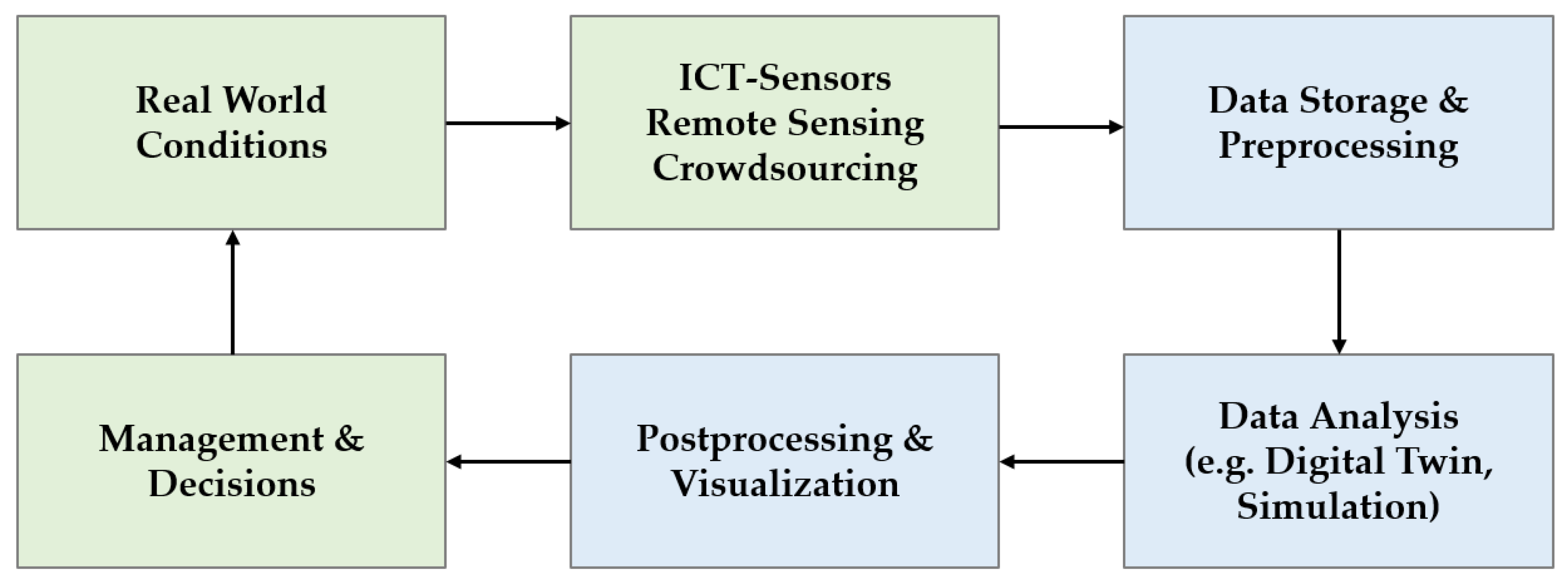
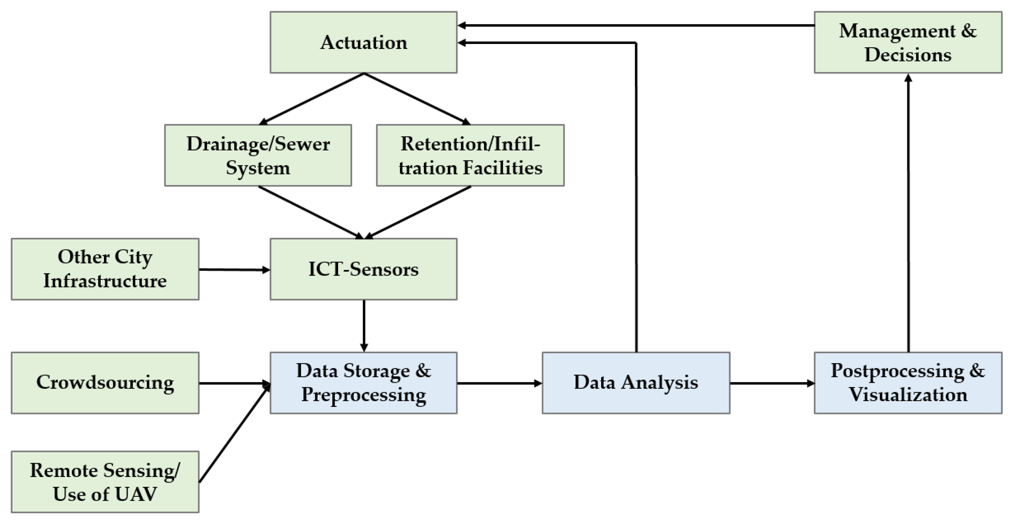
5. Trends in Smart City Solutions for Disaster Management

A smart city can be defined an innovative city that uses information and communications technology and other means to improve quality of life, efficiency of urban operation and services, and competitiveness, while ensuring that it meets the needs of present and future generations with respect to economic, social, environmental, and cultural aspects [10]. Similarly, smart disaster management can be defined as the use of information and communications technology and other technological means to improve the resiliency and preparedness of a city and to support and enhance disaster response and recovery activities. In most cases smart cities, solutions for disaster management fall under one of the following three categories, or a combination thereof:
  • Big data: The collection of data from different sources as well as its analysis and presentation for decision support purposes. This category includes technologies such as artificial intelligence, augmented reality, and crowdsourcing. It also includes the Internet of things, i.e., technologies that are interconnected to create smart object networks in which the objects communicate, exchange information, generate more consistent data, and provide support for strategic decisions and actions [11];
  • Digital twin: A virtual model of a city that dynamically represents all the elements that constitute the city and allows for real-time interaction and data exchange with physical reality [12];
  • Remote sensing and support: The use of aerial or space vehicles for monitoring, information gathering, communications, and logistics [13]. Furthermore, the gathering and fusion of different types of geo-data delivered by aerial and space surveying for monitoring long-term terrain changes and assessing their possible impacts [14].
The use of big data in disaster management generally depends on the disaster phase. Data from static and mobile sensors or crowdsourced internet data can be used for monitoring and assessing exposure and vulnerability to hazards [15]. During an ongoing disaster, social media, mobile phones, and remote sensing data can be gathered for an early assessment of damages and behavioral responses of the population [15]. Among the most popular big data sources are satellite data, social media, and crowdsourcing [16]. They are followed by sensor networks, simulations, mobile GPS, and call data [16].
An IoT-Network can play an important role in a big data approach to disaster management. It consists of connected objects that are fitted with microcontrollers and data transceivers and which communicate according to appropriate protocols [17]. Disasters require special consideration of the applied protocols because each type of disaster has its own notion of occurrence, time of the mishap, and damage ability [18]. As disasters can cut-off the affected region from outside-wired communication links such as overhead wires, antennas, and optic fiber channels, it is important to diversify protocols that depend on different and independent communication infrastructure [18]. Generally, the use of a large number of deployed physical objects, accessed through the Internet, can supply authorities with precise situational information [19]. The improved situational awareness can help to monitor the affected area and predict the occurrence of new disasters [19].
A digital twin brings together five main themes: data management, visualization, situational awareness, planning and prediction, and integration and collaboration [12]. Putting those five themes to use, a digital twin can support and enhance disaster management. Disaster management requires capabilities to anticipate the evolution of a disaster while taking into account the unique characteristics and conditions of a city [20]. A digital twin can integrate real-time and static data from different sources. The data can be analyzed and used for decision-support purposes through visualization and communication of the resulting information. A digital twin is especially effective when a feedback loop is applied in which the decisions and actions are fed back into the digital twin which synthesizes the data and then determines recommended next steps [20]. Typical data sources for a digital twin are sensors, mobile devices, radio-frequency identification (RFID), tag sensing, GPS, and surveillance cameras [21]. Current research is conducted on the integration of real-time object detection data via video analysis to assess collective interactive behavior [22].
Remote sensing data can be used for different purposes. Applications include land use planning, vegetation analysis, thermal condition assessment, hydrography analysis, and geohazard detection [14]. When remote sensing data is used as input for a dynamic model, changes of an urban area and their impact over time can be analyzed. For example, in one case, an increase in vegetation was shown to improve environmental conditions within a city area, while the growth of anthropogenic impacts led to a degradation of the environmental condition [14]. In another case, the analysis of long-term satellite data showed trends in land surface temperature in cities and the contribution of urban development and planning on the formation of urban heat islands [23]. Furthermore, remote sensing data can be combined with IoT applications to increase the spatial and temporal level of detail. Such an integrative approach was investigated with sensors for air temperature, atmospheric pressure, and relative humidity, as well as cloud cover and saturated water [24].
With regard to remote sensing and support, unmanned aerial vehicles (UAV) are an increasingly important element when dealing with a disaster. UAV can be put to action during all phases of disaster management. They can gather data from different sources such as cameras or sensors in areas that cannot be reached via the ground. Disaster information gathering is especially effective when UAV are connected to form a network [13]. Furthermore, UAV can act as communication hubs. They can (re-)establish communication lines that were damaged or destroyed during the disaster. Depending on the type of UAV used they can also serve as means of transport either into or out of the disaster zone [13].
The three categories cannot be strictly separated from each other. A network of connected objects can, for example, act as a data source for either big data or a digital twin. UAV can serve as part of an IoT network. On the other hand, an IoT network can be used as data source in combination with remote sensing. Still, each category has distinct goals, features, and requirements. The following sections will answer the question of if (and how) the smart city solutions in the different categories can—alone or in combination—support and enhance disaster management, specifically when dealing with floods.

6. Literature Overview of Smart Solutions for Flood Management

Due to long term changes in climate, many cities face an increase in the intensity of rainfall events and a higher probability for flooding. Flooding can cause damages to building infrastructure, cut off critical transportation pathways, and lead to other hazards through the resulting defects in electricity and fuel connections [25].

6.1. “Smart” Does Not Have to Be ICT/IoT-Based

There are three main factors that exacerbate flooding risk in cities: too much surface sealing, inadequate drainage systems, and increased land use in floodplains [4]. Cities can increase their resilience by improving these three areas without relying on “smart” (i.e., ICT-based) solutions. Indeed, exposed cities should consider flooding prevention and resilience, including the use of smart city solutions, as one element of the overall transition to a “water smart city”. The approach takes into account the urban water cycle in urban planning [26]. It integrates water management and water supply to cope with climate impacts, resource efficiency, and energy transition to minimize environmental degradation and to improve living conditions in a city [26]. Table 2 summarizes possible measures, as presented in [26] (see [27] for practical applications), that cities can implement to become a water smart city.
The measures shown in Table 2 range from the (single) building level to the district and city level. It is apparent that many of the measures do not rely on ICT or data-based technologies; rather, they help to increase the efficiency of water usage and to restore and support the water cycle in urban areas through means such as an increase in greenery as well as infiltration and retention provisions. Measures such as these can decrease flood risk and can improve the disaster resiliency of a city. Still, smart city solutions can enhance and support urban water management, especially when it comes to dealing with water-based disasters. The following paragraphs present and discuss some approaches for dealing with extreme rainfall and flooding within the above-described framework of the three categories big data, digital twin, and remote sensing and support.

6.2. Holistic Frameworks for Smart Flood Management

Generally, holistic approaches to smart disaster management can be summarized as shown in the flow diagram in Figure 1. The physical realm is depicted in green and consists of the actual real-world conditions as well as the management body and the sensing infrastructure. In the digital realm (blue), the data is stored (for example in a cloud) and preprocessed so that it can be transferred to a model for further analysis and simulation. The results are visualized and handed over to the respective management body, which influences the real-world conditions through its decisions.
Ford et al. present a disaster management model that is based on a digital twin [20]. It consists of three principal parts: (1) components that are not a part of the digital twin such as information on community decision-making and its effects; (2) ICT sensors and data processing modules; and (3) digital twin components that include simulation and visualization tools. The modules are arranged to constitute a feedback loop. The authors state that the loops improve the speed of the processes by removing the time necessary for humans to collect and process data. The model was tested under real-life conditions as a flood alert system (FAS) that informs decision-makers of rainfall events. The FAS integrated rainfall data with hydrologic modeling capabilities to predict the peak flow and height of a runoff hydrograph and the associated backwater effect in a catchment. Empirical results were shown to be accurate across a variety of events.
Ibrahim et al. developed a conceptual design for a smart disaster management system [28]. It describes a scenario for each stage of a disaster and develops model processes for disaster management. The processes specify technical requirements, people’s roles, and responsibilities. The authors find that the addition of ICT to a disaster management system significantly improves the performance of the system due to faster information transmission to the management staff and because ICT sensors can feed controllers installed in electronic gates to open them in order to drain larger amounts of water to reduce the impact of flooding.
Kumar et al. highlight the challenges in designing an informational framework that couples physical sensors and social sensors to collect, fuse, and analyze flooding data [29]. The core of the framework is an event processing engine. The engine converts all incoming data of interest to a common format with regard to three attributes (space, time, theme) so that it can be fed into a prediction model. The output of the framework can be analyzed, and personalized responses can be given back to human actuators. In an experiment, the authors observed a good agreement between the modeled and the observed water level changes during a tropical storm.
In summary, the literature presents different disaster management systems. They act as a framework that combines separate smart city solutions such as ICT sensors, digital twin, or remote sensing into an integrated system (Figure 2). One key attribute of the systems is its components act as a feedback loop in which the results of data analysis are meant to improve decision-making, thereby influencing real-world conditions that are again taken into account when gathering and analyzing new data. Furthermore, the aspect of decision-making and management can be abstracted from human entities so that the flow chart becomes a control loop in which an actuator influences real-world conditions automatically according to a specified threshold. The amount of automation in a smart disaster management system may depend on the availability and reliance of smart infrastructure in a city as well as its desired disaster management style and level of human involvement.

6.3. Smart City Solutions for Specific Aspects of Flood Management

With regard to smart city solutions for specific aspects of disaster management, three types stand out, which will be summarized in the following paragraphs:
  • Smart water storage, drainage, and sewerage;
  • Crowdsourcing flooding data;
  • Use of UAV.

6.3.1. Smart Water Infrastructure

As for smart water infrastructure, different approaches are presented in the literature. For example, Liang et al. address the problem that household rainwater tanks are often not utilized effectively during rainfall events [30]. They present a system of smart rainwater tanks that are controlled during storm events based on information on the temporal rainfall distribution to reduce the peak water discharge rate, thereby mitigating flooding at the level of allotments. Yamashita et al. show that bottom-up approaches at the single-household or district level, such as the increased use of rainwater tanks, rainwater-harvesting houses, or communal cisterns, can decrease the dependency on infrastructure-intensive public works to mitigate disaster risks [27]. At the same time, water monitoring data can encourage the public to become involved more in urban-runoff reduction.
At the city level, Keung et al. propose a real-time urban drainage monitoring system [31]. Water flow and level sensors are distributed in the drainage system. They collect data and transfer it over LAN, WAN, WiFi, and Internet to a cloud storage (see also [32]). There, the drainage situation is analyzed with an artificial neural network (ANN), which estimates the drains to be either absorbent, blocked, cloggy, or free. Ostojin et al. follow a similar approach [33]. They enhance the monitoring of the sewer system with a real-time utilization of in-network storage capacity to attenuate flow peaks, thereby reducing the risk of surface water flooding. The system controls flows and utilizes untapped water network capacity through local autonomous real-time control using AI routines which act on water level data.

6.3.2. Crowdsourcing Flooding Data

Crowdsourcing basically means collecting and analyzing data from dispersed sources to derive relevant disaster information. Examples include the analysis of video streams, social media, online news articles, and vehicle sensors.
Berliana et al. present a method to estimate rainfall conditions from CCTV video streams, converting a mainly qualitative format into quantitative data [34]. They use machine learning to develop a video interpretation model that references data from weather stations. Results indicate a high and increasing accuracy of the video analysis with a growing amount of reference data and an adequate K-value for the machine learning algorithm. The overall approach is especially interesting in countries with a high density of CCTV cameras, but could nevertheless be useful in other countries, as video surveillance (at least in important public areas) is common in many countries around the world.
Zarei et al. suggest a method for detecting water overflows in a city by extracting flood information such as dates and locations from online news articles [35]. The method consists in crawling flood-related newspaper articles, extracting and selecting features such as names and key phrases, and classifying the news into flood-related and non-flood-related news. They show that different classifiers lead to different precision and recall values with f-measures ranging from 0.77 to 0.82, indicating the usefulness of the method for practical application. The obtained flood information can be visualized in a map format to support local authorities.
Khatoon et al. present a cloud-based solution for disaster and emergency management using social media [36]. They authors integrate a disaster ontology, i.e., a semantic specification of the disaster domain, along with natural language processing and annotation tools into a cloud-enabled crowdsourcing platform. For practical applications, they develop a visual interface for incident monitoring by end-users. The authors show that the solution can automatically extract actionable disaster information from multiple internet sources.
Calafate et al. do not focus on social media and online-news [37] rather, they show that sensors on cars can be used to extract disaster information. The authors derive rainfall intensity information from windshield sensor data. Through simulations, they show that the quality of the results depends on the vehicle density in the observed area, though they state that the solution is effective even when the vehicle density is rather low (about 4 devices per square kilometer) and achieves a high accuracy when increased to about 20.
Lastly, Garcia et al. propose a flood alert system (FAS) that fuses data from wireless sensors with flood reports submitted by users through a smartphone app to calculate a flood index [38]. The app provides users with information about the local flood severity, as well as weather forecasts and emergency mobility routes that consider the flood-severity. The authors point out that the availability, validation, and quantification of user reports is a critical aspect of the system.

6.3.3. Use of UAV

With regard to their role in disaster management, a key advantage of UAV is their contribution to situational awareness during the assessment and response stage of a disaster, when ICT sensors become less effective [13]. Furthermore, they can enlarge or substitute a communication network to ensure an exchange of information between agents inside and outside the disaster region. Generally, UAV need stable weather conditions to operate effectively. Therefore, they are well suited for assessing and responding to hydrological disasters such as floods [13,39].
One challenge with the use of UAV is their limited battery capacity, which limits their time of operation. Kim et al. address the problem by introducing a concept that utilizes public transportation as a bridgehead [40]. In the model, UAV are continuously recharged on public buses, trams, or other vehicles, while others keep monitoring traffic conditions and collect data from neighboring ground stations. Other UAV-related works focus on UAV as signal relays [41]; for example, between ground-based LoRa-nodes and remote base stations [42].
Generally, UAV present a number of advantages and potentials for disaster management. Nevertheless, there are limits regarding their practical application. These include the resilience of relay networks consisting of UAV, how to guide UAV to critical areas most efficiently, ways to fuse data inside UAV-networks (e.g., including social media, video streams, text messages, etc.), managing trade-offs between power-use for data transmission and aerial movements, and choosing recharging strategies to ensure optimal service [41,43].

6.4. Summary

There are three main factors that exacerbate flooding risk in cities: too much surface sealing, inadequate drainage systems, and increased land use in floodplains [4]. Cities can increase their resilience by improving these aspects without relying on “smart” (i.e., ICT-based) solutions. Still, smart city solutions can enhance and support water management, especially when it comes to dealing with floods. The literature presents a large variety of smart solutions for flood management. Selected solutions for different areas of disaster management have been presented and discussed (Table 3).
They range from single applications on the operational level to frameworks that govern the interaction between technological sub-systems and take into account real-world management processes. One attribute of holistic management systems is that they act as a feedback loop in which the results of the data analysis are meant to improve decision-making, thereby influencing real-world conditions that are again taken into account when gathering and analyzing new data. Furthermore, the aspect of decision-making and management can be abstracted from human entities, leading to a control loop in which an actuator influences real-world conditions automatically according to specified goals.
With regard to solutions for specific aspects of disaster management, three salient concepts were highlighted: smart water storage, drainage, and sewerage; crowdsourcing flooding data; and use of UAV. Smart water infrastructure on the local level can encompass rainwater tanks, rainwater-harvesting houses, or communal cisterns, that are connected through ICT technologies for monitoring, sensing, and actuation purposes. The same principle holds for city-wide applications, with a focus on existing drainage and sewer systems. Crowdsourcing helps to diversify data sources, thereby potentially increasing the gain in relevant disaster information. Possible sources include video streams, social media, online news articles, and vehicle sensors. In this regard, UAV can act as further source of data. The nature of UAV as fragile airborne entities comes with its own challenges. Nevertheless, UAV can greatly enhance and support disaster management in its different phases. For example, they can improve situational awareness and communication during a disaster, when ground-based sensors and networks become less effective.

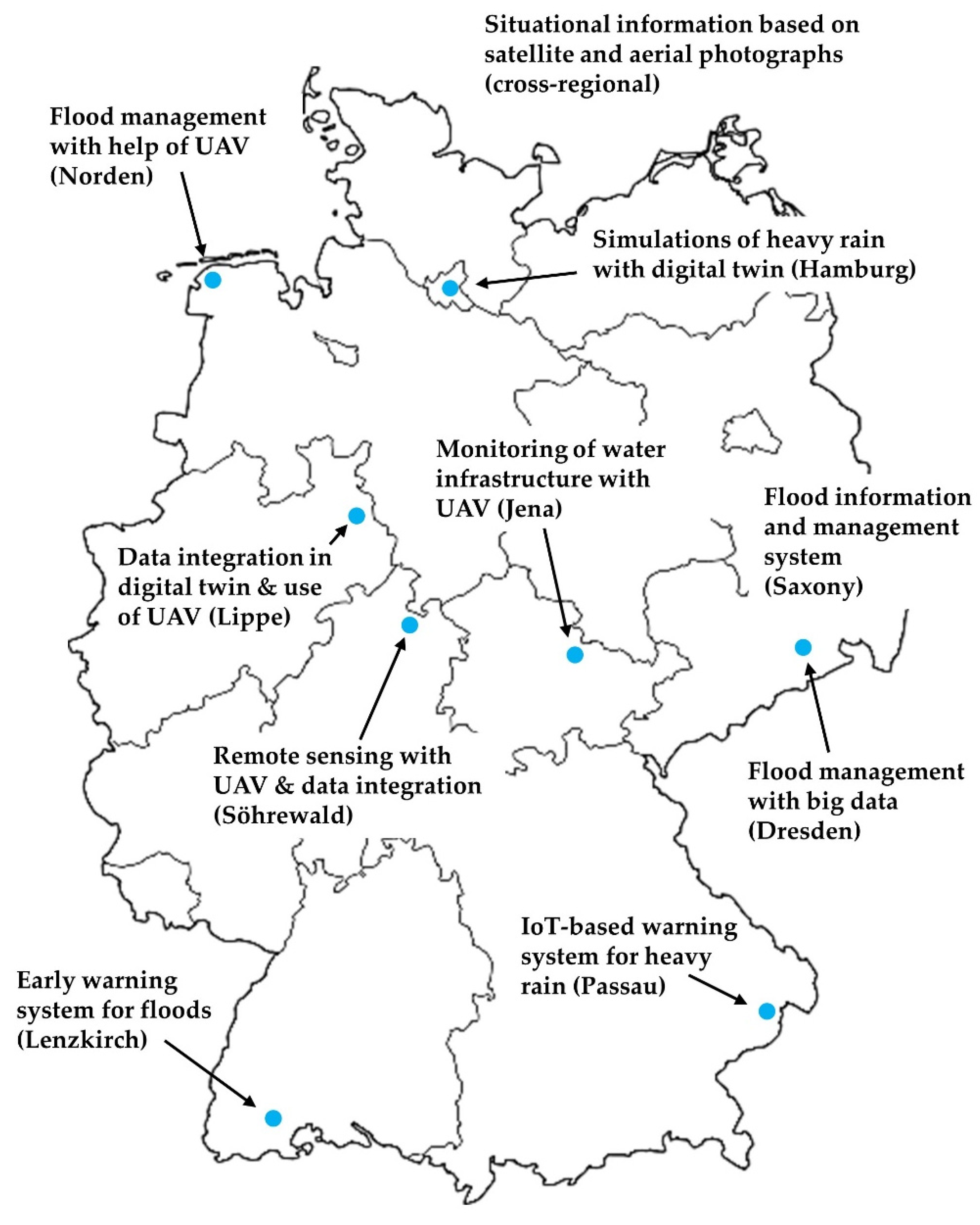
7. Smart Flood Management in Selected German Cities

Cities all over the world use different approaches to the development and the implementation of smart solutions for flood management. The following examples serve to give an impression of the current implementation status in Germany.

7.1. Insights into Smart Flood Management Activities in Germany

The examples of smart flood management activities in Germany are clustered according to the categories introduced in Section 5.

7.1.1. Big Data

The Flood Information and Management System of the Saxony State Flood Center has been in operation since 2018. It collects and analyzes water level data across the entire federal state [44]. Part of the system comprises sensor stations in nine river basins. They measure the amount of precipitation and the corresponding water levels. The system integrates warnings issued by the Federal Meteorological Service with other relevant hydrographic and meteorological information. The data is collected centrally, evaluated, and communicated automatically and in real time to more than 1000 recipients. The state administration, fire brigade, disaster control, and other authorities can initiate the appropriate protective measures depending on the warning level [44]. Furthermore, different perspectives are taken into account: flood warnings for river basins, early flood warnings for small catchment areas, and weather warnings.
A different approach to data-based flood management has been conducted in Dresden, the capital of Saxony, since 2016 [45]. Scientific institutions such as the Fraunhofer Institute for Transportation and Infrastructure Systems advised the city on the use of big data in dealing with flood disasters. The aim of the project is to integrate information shared publicly on social networks into the decision-making process for flood protection. Specifically, images from social media are used to assess the current situation and to develop adequate options for action [45].
The city of Lenzkirch in the state of Baden-Württemberg tested a local early warning system for detecting flood disasters at an early stage since 2020. The region has been affected by floods before. Hence, the city took preventive measures to deal with the increased flooding risk. A few years ago, the city installed radar sensors along the major river courses to communicate the current water level to the fire brigade [46]. In the meantime, smaller tributaries have also been equipped with measuring probes. Additionally, the data network combines weather and tide gauge data with soil moisture monitoring [47]. The system has recently been consolidated to bring together the different data streams in order to improve the accessibility of the data [46]. For example, firefighters now receive the measured values from the sensors directly on their mobile phones.
Since 2020, the Bavarian city of Passau has utilizes an IoT system for big data purposes that issues warnings of heavy rain [48]. The system calculates the amount of precipitation through weather sensors and water level gauges on the various rivers and streams and provides information or warnings within a few minutes. The IoT sensors generate data at essential points. With the data, the system calculates flood hotspots. It uses a combination of expert knowledge and computer models to assess critical areas and make predictions based on real-time data. When certain thresholds are met, the system alerts citizens to the dangerous situation [48].

7.1.2. Digital Twin

In 2021, Hamburg carried out a simulation of an extreme rain event. The goal was to better understand heavy rain events and to contribute to forward-looking urban planning [49]. The simulation is embedded in an environment of different projects pursued by the city administration. They examine possible ways to adapt to the consequences of climate change and, in particular, to manage flood risks. The simulations utilize computer-based water body models that take into account the water infrastructure. The results are used to pursue the goals of the city’s climate plan.
A different example, the Lippe-region in the state of North Rhine-Westphalia, has been developing a digital twin since 2021. In one application, topographical surface data is evaluated with regard to potential water flow paths [50]. The digital twin is able to integrate different data types such as data on property, terrain models, 3D-models of buildings, aerial images, floodplains, vegetation, soil erosion, and information on protected areas, as well as the development plans of cities and municipalities [50]. The project offers an interactive web-based map with hazard information on heavy rainfall for the entire federal state.

7.1.3. Remote Sensing and Support

In addition to the activities surrounding the development of a digital twin, the Lippe-region in North Rhine-Westphalia has been testing how drone data and 3D-models can improve the early warning of heavy rainfall events [51]. A variety of different services are combined for analysis and evaluation. These include, for example, information on vegetation and soil erosion, land-use planning, and building information. UAV help to determine the identified hazard zones in even greater detail and to compare them with historical damage events. Observations and video recordings by the population are also included. Discharge simulations that apply models of watersheds and catchment areas as well as flow paths determine possible flooding scenarios. As a practical example, the data can be utilized to create heavy rain hazard maps [51].
The district of Söhrewald, in the federal state of Hesse, used UAV to map and measure parts of the terrain. They generated an elevation profile with an accuracy of 2.5 cm. The profile was stored in a database together with existing data on the sewer network, buildings, and weather patterns [52]. Different simulation models access the database and thereby enable insights to be gained about the development of weather conditions and possible danger spots [52]. The aim of the simulations is to identify and implement preventive measures to protect against flooding.
Besides their use for prevention and ex-ante data creation, UAV can also gather information on ongoing or past flood disasters. Fire brigades and disaster control agencies in many cities in Germany are already equipped with drones and apply them as part of their operations. For example, the fire brigade of Bedekaspel city in Lower Saxony used drones during a flood in 2021 to create aerial images of the current situation in order to draw conclusions about the extent of the disaster and possible measures [53].
The Thuringian city of Jena carried out drone flights over the river Unstrut in 2022 to take stock of aging flood protection facilities [54]. The pictures and videos taken by the drones were used to record and document the condition of the water bodies, banks, and flood protection facilities. The aim is to detect dangerous spots or obstructions of the river by floating debris at an early stage. The images help prioritize infrastructure maintenance and plan the removal of illegally disposed rubbish [54].
The Center for Satellite based Crisis Information takes satellite and aerial photographs of disaster regions throughout Germany. In one application, the remote sensing data is used to create situational information during a flood and forward relevant information to management agencies such as the Joint Reporting and Situation Center of Federal and State Governments [55]. For example, during floods in 2013 and 2021, the data helped to assess the situation and contributed to dealing with the floods.

7.2. Learnings from Smart Flood Management Activities in Germany

Cities and regions throughout Germany already use a range of smart solutions for disaster management (Figure 3). They see the adaptation to the effects of climate change as a major issue. Many of them have identified disaster management as a key challenge and consider the use of digital and “smart” technologies an important part of the solution. While doing so, cities steer the respective activities in a goal-oriented way. They do not regard smart solutions and digital technologies as an end in themselves, but rather as an enhancement of existing procedures and methodologies for disaster management and urban planning.
Currently, the main applications of smart solutions for flood management comprise real-time information services for authorities, rescue teams, and citizens. Here, the field of big data seems to be prevalent. Cities aim to bring together already existing data horizontally (on city level) and vertically (from sources on state and federal level). In addition, they integrate new data sources such as IoT sensors and data collected by UAV. There are, however, not a lot of examples for the application of IoT-sensors that go further than what cities already do, as most cities have access to data about flows and levels of their main water bodies. UAV seem to be highly accepted by fire brigades and rescue teams. Furthermore, UAV are regularly applied for gathering geographical data that are used for strategic planning purposes. Moreover, in a strategic context, the digital twin shows potential to act as a central data hub that combines the different data streams and makes them available for different use cases.
All in all, smart solutions for flood management are in an early phase of adoption, albeit with a trajectory towards permanent implementation for specific use-cases concerning the management of floods. So, the following questions arise: what could and should cities do to further advance their flood management capabilities with digital technologies? At which points do the limitations of integrated urban flood management arise?

7.3. Limitations to Urban Flood Management

Urban flood management is a crucial aspect of protecting communities and infrastructure from the impacts of floods. It aims at assessing and reducing flood risk, as well as preparing for response and recovery with the purpose of minimizing disturbances, disruptions, and costs in relation to a city’s development plan [56]. Urban flood management is a complex and challenging undertaking for cities, as there are several limitations that can impact its effectiveness. Changes in land use, such as urbanization and deforestation, can impact the natural hydrology of an area, leading to increased runoff and increased risk of flooding [57]. Especially in times when climate change is leading to more frequent and intense rainfall and overall rising sea levels, flood management is challenging and presents several limitations [57].
One of the points at which flood management is likely to reach a limit is the simple fact that it can be expensive and there may be non-sufficient funding available. Partnership funding models can help, although they come with their own challenges like higher costs due to longer decision-making practices [56]. Flood management requires a comprehensive and integrated approach. This includes long-term planning, hazard assessment, and risk reduction measures. However, many communities, especially smaller ones, lack the necessary planning and coordination resources to prepare adequately for floods and manage them effectively. In urban areas, there is limited space for the construction of flood protection measures due to other pressures such as economic activity and food production [57]. Furthermore, in many areas, the infrastructure for managing floods, such as levees, dams, and drainage systems, is aging and in need of repair or replacement. Such transformation processes are lengthy and carry the risk that, over time, successively installed systems become obsolete and thus no longer compatible. Furthermore, cities have to make sure that water, transportation, energy, and other important infrastructure is protected during flood events [56]. A solution is an integrated planning approach, that includes data on infrastructure as well as models (and possibly simulations) of different rainfall and flooding scenarios.
Effective collaboration among stakeholders, such as local governments, emergency management agencies, and community organizations, is another critical component of urban flood management. It involves sharing data and information on past flood events, current conditions, and potential risks, as well as developing and using common tools and models for risk assessment and planning. A decentralized organization of urban flood management, in which individuals, households, and communities become involved, can promote co-operation, although decentralization can come with its own problems like higher cost and negative impacts on social equality [56]. Still, creating a system in which the local community is involved and implements projects that solve common goals of flood management comes with many advantages, one of which is the co-existence of different approaches and techniques [56].
Another limit for urban flood management is posed by the imbalance of social justice. In particular, people with little economic power are most exposed to the floods, as they have no choice but to settle in the most vulnerable areas [57]. This problem can only be solved by an integrated overall solution that takes into account the specific aspects of the social structure.
One of the most important prerequisites for flood management is raising awareness among citizens and decision-makers. In order to initiate and implement a transformation process to more resilient communities, it is necessary to convince authorities of the meaningfulness of long-term preventive measures, even if they seem to offer no short-term benefits. In this sense, political considerations, such as local opposition to proposed flood management measures in favor of other municipal projects, can pose a limit to flood management efforts. A lack of public awareness and participation in flood management leads to resistance to necessary changes and limited participation in flood preparation activities. This may be one of the most substantial limits for urban flood management.
Overall, the limitations require careful consideration and strategic planning to overcome and to ensure that communities and infrastructure are protected from the impacts of floods.

8. How Smart Solutions Address the Challenges of Flood Management

The limitations notwithstanding, smart solutions address many of the problems cities face in dealing with flood disasters. This section summarizes salient concepts among the presented solutions and technologies and outlines the challenges and problems they address (Table 4).
As for big data applications, their main improvement compared to conventional flood management stems from the integration of different data streams to improve situational awareness as well as the speed and quality of processes and management decisions. Big data helps cities to monitor and project heavy rainfall and corresponding water levels, implement data-driven early warning systems, and assess disasters after they occurred to prepare for and mitigate the impact of future disasters. Furthermore, big data can help to take the “human element” out of the management system, i.e., controlling capacity and flows of water infrastructure automatically based on strategic target values and thresholds. On the other side, humans can be a major contribution to a big data approach. They can provide valuable information about rain and water levels, thereby helping to coordinate response activities, localize danger zones, and stay in contact with affected citizens. Big data allows the integration of unusual data sources that are originally not intended for water management. Examples include CCTV streams, online news articles, rain sensors in cars, and social media. In summary, big data addresses key challenges of municipal flood management such as accessing relevant up-to-date data, allocating resources adequately, and implementing effective early warning systems.
Digital twins address the key problem of interpreting large amounts of complex and diverse data. In that regard, they show their biggest potential when combined with big data. Digital twins not only help to improve the speed and quality of management decisions by visualizing complex data in a simple and accessible way during a disaster; they can simulate the evolution of a disaster while taking into account the unique characteristics and conditions of a city, thereby acting as a critical element of an early warning system. Digitals twins solve major problems municipalities face when dealing with floods. Among them are monitoring and predicting heavy rainfall and water levels, implementing an early warning system, and identifying city-specific weaknesses and risk factors.
Lastly, remote sensing and support solves the problem of physical and informational accessibility of a disaster zone. For example, real-time aerial monitoring of a disaster zone helps to gather relevant up-to-date information and coordinate response activities. Therefore, UAV play an increasingly important role when it comes to dealing with floods. They can act as signal hubs, ensuring communications between management teams or between authorities and citizens, and help to transport needed goods to the zone quickly and, possibly, even automatically.

9. Recommendations for Cities

Cities that want to implement smart city solutions for the management of flood disaster can consider the following recommendations as guidance:
  • Review projections of expected rainfall and water flows that are (mostly) based on historical data; adjust projections with calculations that take into account established climate change models;
  • Set the goal to become a “water smart city” and evaluate current preventive measures (digital and analog/conventional) at the building, district, and city level;
  • Develop knowledge and skills in the key categories of smart solutions for disaster management, i.e., big data, Internet of things, digital twins, UAV, and remote sensing;
  • If possible, create a specialized unit in the organization in which the employees become experts in the fields of smart city and digitalization who help administrative units to implement innovative projects as part of their ongoing duties;
  • View investments in smart city solutions as part of an integrated risk management process, i.e., as a way to minimize opportunity cost in the long-term.

10. Conclusions

The disaster events of recent years indicate that the frequency and intensity of floods is increasing to an extent that stretches the disaster management abilities of cities to its limit. Cities are responsible for establishing adequate protection against disasters such as floods. However, in many regions across Germany, the existing water infrastructure is not designed to absorb the amounts of water that are expected in the years to come. Furthermore, many traditional preventive measures do not seem to be adequate anymore. Considerations on how to deal with floods on a city level are urgent.
This paper shows that digital technologies can be of great benefit for flood management in cities. On the one hand they can enhance existing infrastructure and management processes in city administrations. On the other hand, there are smart solutions such as digital twins that provide altogether new approaches to data management that can also improve flood management capabilities. Smart solutions not only help to deal with ongoing search and rescue activities, but also provide the means to consider flood management as one aspect in the broader scope of sustainable city planning. For example, based on a reliable flood and heavy rain analysis undertaken with smart solutions, cities can develop effective precautionary concepts and implement them together with different municipal stakeholders.
Climate change adaptation and disaster management are long-term challenges whose effectiveness will become apparent with a time lag. Disaster management is particularly visible when it is lacking. If environmental impacts cause comparatively little damage due to effective mitigation and risk reduction, the need for smart solutions is less apparent than if measures fail or are not existent. Therefore, cities should proactively examine the effectiveness of their respective disaster management and consider areas where smart solutions would have a high marginal benefit. At the same time, measures should not be considered individually but as part of an integrated concept working towards a common goal.

Author Contributions

Conceptualization, methodology, research, and writing: N.J. and K.V. All authors have read and agreed to the published version of the manuscript.

Funding

This research received no external funding.

Data Availability Statement

Not applicable.

Conflicts of Interest

The authors declare no conflict of interest.

References

  1. Prognos. Bezifferung von Klimafolgekosten in Deutschland [Quantification of Climate Impact Costs in Germany]. Available online: https://www.prognos.com/de/projekt/bezifferung-von-klimafolgekosten-deutschland (accessed on 15 December 2022).
  2. Kahlenborn, W.; Porst, L.; Voß, M.; Hölscher, L.; Undorf, S.; Wolf, M.; Schönthaler, K.; Crespi, A.; Renner, K.; Zebisch, M.; et al. Klimawirkungs- und Risikoanalyse 2021 für Deutschland—Teilbericht 6: Integrierte Auswertung—Klimarisiken, Handlungserfordernisse und Forschungsbedarfe. [Climate Impact and Risk Analysis 2021 for Germany—Substudy Report 6: Integrated Evaluation—Climate Risks, Action Requirements and Research Needs]. Report on behalf of the Federal Environment Agency. Climate Change No. 25/2021. Available online: https://www.umweltbundesamt.de/sites/default/files/medien/479/publikationen/kwra2021_teilbericht_6_integrierte_auswertung_bf_211027_0.pdf (accessed on 15 December 2022).
  3. Deutschländer, T.; Dalelane, S. Auswertung regionaler Klimaprojektionen für Deutschland hinsichtlich der Änderung des Extremverhaltens von Temperatur, Niederschlag und Windgeschwindigkeit. [Evaluation of Regional Climate Projections for Germany with Respect to Changes in the Extreme Behavior of Temperature, Precipitation, and Wind Speed]. Report by the German Weather Service. October 2012. Available online: https://www.dwd.de/DE/klimaumwelt/klimaforschung/klimaprojektionen/extremereignisse/abschlussbericht-2012.html (accessed on 15 December 2022).
  4. European Environment Agency. Urban ADAPTATION in Europe: How Cities and Towns Respond to Climate Change. EEA Report No 12/2020. Available online: https://www.eea.europa.eu/publications/urban-adaptation-in-europe (accessed on 15 December 2022).
  5. Grothues, E.; Köllner, B.; Ptak, D.; Dalelane, C.; Deutschländer, T.; Ertel, H.; Hafer, M.; Halbig, G.; Kesseler-Lauterkorn, T.; Koch, C.; et al. Klimawandelgerechte Metropole Köln. Climate Change Compatible Metropolis Cologne. Final Report. North Rhine-Westphalia State Agency for Nature, Environment and Consumer Protection. Technical Report No. 50. Recklinghausen 2013. Available online: https://www.lanuv.nrw.de/fileadmin/lanuvpubl/3_fachberichte/30050.pdf (accessed on 15 December 2022).
  6. Center for Disaster Management and Risk Reduction Technology. Risk Map Germany. Available online: https://www.cedim.kit.edu/english/166.php (accessed on 5 February 2023).
  7. Federal Ministry for the Environment, Nature Conservation, Nuclear Safety and Consumer Protection. Informationsplattform zu Hydrologischen Extremereignissen (Hochwasser, Niedrigwasser). Information Platform on Extreme Hydrological Events (Floods, Low Water). Available online: https://undine.bafg.de/index.html (accessed on 5 February 2023).
  8. BBC. Europe Floods: At Least 120 Dead and Hundreds Unaccounted for. Available online: https://www.bbc.com/news/world-europe-57858829 (accessed on 5 February 2023).
  9. Federal Emergency Management Agency. Phases of Emergency Management. Available online: https://www.hsdl.org/?view&did=488295 (accessed on 5 February 2023).
  10. UNECE. Sustainable Smart Cities. Available online: https://unece.org/housing/sustainable-smart-cities (accessed on 15 December 2022).
  11. de França Bail, R.; Kovaleski, J.L.; da Silva, V.L.; Pagani, R.N.; de Genaro Chiroli, D.M. Internet of things in disaster management: Technologies and uses. Environ. Hazards 2020, 20, 493–513. [Google Scholar] [CrossRef]
  12. Shahat, E.; Hyun, C.T.; Yeom, C. City Digital Twin Potentials: A Review and Research Agenda. Sustainability 2021, 13, 3386. [Google Scholar] [CrossRef]
  13. Erdelj, M.; Natalizio, E.; Chowdhury, K.; Akyildiz, I. Help from the Sky: Leveraging UAVs for Disaster Management. IEEE Pervasive Comput. 2017, 16, 24. [Google Scholar] [CrossRef]
  14. Popov, M.; Fedorovsky, O.; Stankevich, S.; Filipovych, V.; Khyzhniak, A.; Piestova, I.; Lubskyi, M.; Svideniuk, M. Remote Sensing Technologies and Geospatial Modelling Hierarchy for Smart City Support. In Proceedings of the ISPRS Annals of the Photogrammetry, Remote Sensing and Spatial Information Sciences, Kyiv, Ukraine, 4–6 December 2017; Volume IV-5/W1, pp. 51–56. [Google Scholar] [CrossRef] [Green Version]
  15. Anttila-Hughes, J.; Dumas, M.; Jones, L.; Pestre, G.; Qiu, Y.; Levy, M.; Letouzé, E.; Sala, S.; Schwarz, B.; Shoup, N.; et al. Big Data for Climate Change and Disaster Resilience: Realizing the Benefits for Developing Countries. Data-Pop Alliance Synthesis Report. September 2015. Available online: https://datapopalliance.org/wp-content/uploads/2015/11/Big-Data-for-Resilience-2015-Report.pdf (accessed on 15 December 2022).
  16. Yu, M.; Yang, C.; Li, Y. Big Data in Natural Disaster Management: A Review. Geosciences 2018, 8, 165. [Google Scholar] [CrossRef] [Green Version]
  17. Sharma, K.; Anand, D.; Sabharwal, M.; Tiwari, P.K.; Cheikhrouhou, O.; Frikha, T. A Disaster Management Framework Using Internet of Things-Based Interconnected Devices. Math. Probl. Eng. 2021, 2021, 9916440. [Google Scholar] [CrossRef]
  18. Ray, P.P.; Mukherjee, M.; Shu, L. Internet of Things for Disaster Management: State-of-the-Art and Prospects. IEEE Access 2017, 5, 18818–18835. [Google Scholar] [CrossRef] [Green Version]
  19. Boukerche, A.; Coutinho, R.W.L. Smart Disaster Detection and Response System for Smart Cities. In Proceedings of the 2018 IEEE Symposium on Computers and Communications (ISCC), Natal, Brazil, 25–28 June 2018; pp. 1102–1107. [Google Scholar] [CrossRef]
  20. Ford, D.N.; Wolf, C.M. Smart Cities with Digital Twin Systems for Disaster Management. J. Manag. Eng. 2020, 36, 04020027. [Google Scholar] [CrossRef] [Green Version]
  21. Elvas, L.B.; Mataloto, B.M.; Martins, A.L.; Ferreira, J.C. Disaster Management in Smart Cities. Smart Cities 2021, 4, 819–839. [Google Scholar] [CrossRef]
  22. Mavrokapnidis, D.; Mohammadi, N.; Taylor, J. Community Dynamics in Smart City Digital Twins: A Computer Vision-based Approach for Monitoring and Forecasting Collective Urban Hazard Exposure. In Proceedings of the 54th Hawaii International Conference on System Sciences, Kauai, HI, USA, 5 January 2021. [Google Scholar] [CrossRef]
  23. Polydoros, A.; Mavrakou, T.; Cartalis, C. Quantifying the Trends in Land Surface Temperature and Surface Urban Heat Island Intensity in Mediterranean Cities in View of Smart Urbanization. Urban Sci. 2018, 2, 16. [Google Scholar] [CrossRef] [Green Version]
  24. Kwon, Y.J.; Lee, D.K.; Lee, K. Determining Favourable and Unfavourable Thermal Areas in Seoul Using In-Situ Measurements: A Preliminary Step towards Developing a Smart City. Energies 2019, 12, 2320. [Google Scholar] [CrossRef] [Green Version]
  25. Kuttler, W.; Oßenbrügge, J.; Halbig, G. Städte [Cities]. In Klimawandel in Deutschland. Entwicklung, Folgen, Risiken und Perspektiven [Climate Change in Germany. Development, Consequences, Risks, and Prospects]; Brasseur, G.P., Jacob, D., Schuck-Zöller, S., Eds.; Springer: Berlin, Germany, 2017; pp. 226–233. [Google Scholar] [CrossRef] [Green Version]
  26. Hattum, T.; Blauw, M.; Jensen, M.B.; de Bruin, K. Towards Water Smart Cities: Climate Adaptation is a Huge Opportunity to Improve The Quality of Life in Cities. Wageningen Environmental Research Report 2016. Available online: https://edepot.wur.nl/407327 (accessed on 15 December 2022).
  27. Yamashita, S.; Watanabe, R.; Shimatani, Y. Smart Adaptation to Flooding in Urban Areas. Procedia Eng. 2015, 118, 1096–1103. [Google Scholar] [CrossRef] [Green Version]
  28. Ibrahim, T.; Mishra, A. A Conceptual Design of Smart Management System for Flooding Disaster. Int. J. Environ. Res. Public Health 2021, 18, 8632. [Google Scholar] [CrossRef] [PubMed]
  29. Kumar, S.A.P.; Bao, S.; Singh, V.; Hallstrom, J. Flooding disaster resilience information framework for smart and connected communities. J. Reliab. Intell. Environ. 2019, 5, 3–15. [Google Scholar] [CrossRef]
  30. Liang, R.; Di Matteo, M.; Maier, H.R.; Thyer, M.A. Real-Time, Smart Rainwater Storage Systems: Potential Solution to Mitigate Urban Flooding. Water 2019, 11, 2428. [Google Scholar] [CrossRef] [Green Version]
  31. Keung, K.L.; Lee, C.K.M.; Ng, K.K.H.; Yeung, C.K. Smart City Application and Analysis: Real-time Urban Drainage Monitoring by IoT Sensors: A Case Study of Hong Kong. In Proceedings of the 2018 IEEE International Conference on Industrial Engineering and Engineering Management (IEEM), Bangkok, Thailand, 16–19 December 2018; pp. 521–525. [Google Scholar] [CrossRef]
  32. Perumal, T.; Sulaiman, M.N.; Leong, C.Y. Internet of Things (IoT) enabled water monitoring system. In Proceedings of the 2015 IEEE 4th Global Conference on Consumer Electronics (GCCE), Osaka, Japan, 27–30 October 2015; pp. 86–87. [Google Scholar] [CrossRef]
  33. Ostojin, S.; Shepherd, W.; Williams, K.; Simões, N.; Steinhardt, J. CENTAUR: Smart Utilization of Wastewater storage capacity to prevent flooding. In Proceedings of the CIWEM UDG Autumn Conference & Exhibition 2017, Blackpool, UK, 8–10 November 2017. [Google Scholar] [CrossRef]
  34. Berliana, S.; Slamet, L.; Maryadi, E.; Susanti, I.; Nurlatifah, A. Evaluation of CCTV Data For Estimating Rainfall Condition. In Proceedings of the 2nd International Conference on Tropical Meteorology and Atmospheric Sciences, Jakarta, Indonesia, 23–25 March 2021. [Google Scholar] [CrossRef]
  35. Zarei, F.; Nik Bakht, M. Automated Detection of Urban Flooding from News. In Proceedings of the 36th International Symposium on Automation and Robotics in Construction (ISARC 2019), Banff, AB, Canada, 21–24 May 2019; pp. 515–520. [Google Scholar] [CrossRef] [Green Version]
  36. Khatoon, S.; Asif, A.; Hasan, M.M.; Alshamari, M. Social Media-Based Intelligence for Disaster Response and Management in Smart Cities. In Artificial Intelligence, Machine Learning, and Optimization Tools for Smart Cities; Pardalos, P.M., Rassia, S.T., Tsokas, A., Eds.; Springer International Publishing: Berlin/Heidelberg, Germany, 2022. [Google Scholar] [CrossRef]
  37. Calafate, C.T.; Cicenia, K.; Alvear, O.; Cano, J.C.; Manzoni, P. Estimating rainfall intensity by using vehicles as sensors. In 2017 Wireless Days; IEEE: Piscataway, NJ, USA, 2017; pp. 21–26. [Google Scholar] [CrossRef]
  38. Garcia, V.M.; Granados, R.P.; Medina, M.E.; Ochoa, L.; Mondragon, O.A.; Cheu, R.L.; Villanueva-Rosales, N.; Rosillo, V.M. Management of Real-Time Data for a Smart Flooding Alert System. In Proceedings of the 2020 IEEE International Smart Cities Conference (ISC2), Piscataway, NJ, USA, 28 September–1 October 2020; pp. 1–8. [Google Scholar] [CrossRef]
  39. Nikhil, N.; Shreyas, S.M.; Vyshnavi, G.; Yadav, S. Unmanned Aerial Vehicles (UAV) in Disaster Management Applications. In Proceedings of the 2020 Third International Conference on Smart Systems and Inventive Technology (ICSSIT), Tirunelveli, India, 20–22 August 2020; pp. 140–148. [Google Scholar] [CrossRef]
  40. Kim, H.; Mokdad, L.; Ben-Othman, J. Designing UAV Surveillance Frameworks for Smart City and Extensive Ocean with Differential Perspectives. IEEE Commun. Mag. 2018, 56, 98–104. [Google Scholar] [CrossRef]
  41. Erdelj, M.; Natalizio, E. UAV-assisted disaster management: Applications and open issues. In Proceedings of the 2016 International Conference on Computing, Networking and Communications (ICNC), Kauai, HI, USA, 15–18 February 2016; pp. 1–5. [Google Scholar] [CrossRef] [Green Version]
  42. Saraereh, O.A.; Alsaraira, A.; Khan, I.; Uthansakul, P. Performance Evaluation of UAV-Enabled LoRa Networks for Disaster Management Applications. Sensors 2020, 20, 2396. [Google Scholar] [CrossRef] [PubMed]
  43. Saif, A.; Dimyati, K.; Noordin, K.A.; Alsamhi, S.H.; Hawbani, A. Multi-UAV and SAR collaboration model for disaster management in B5G networks. Internet Technol. Lett. 2021, 310, e310. [Google Scholar] [CrossRef]
  44. Move-Online. Mit Big Data gegen Hochwasser [Using Big Data to Combat Flooding]. Available online: https://www.move-online.de/meldung_29034_Mit+Big+Data+gegen+Hochwasser.html (accessed on 15 December 2022).
  45. Quantic Digital. Big-Data Flutüberwachung in Dresden—Fraunhofer Institute IVI [Big-Data Flood Monitoring in Dresden—Fraunhofer Institute IVI]. Available online: https://www.quantic.de/news-blog/2017-big-data-flutberwachung (accessed on 15 December 2022).
  46. Basters, S.; Lehmann, J. Hochwasser-Frühwarnsystem Wird in Lenzkirch Getestet [Flood Early Warning System Tested in Lenzkirch]. Available online: https://www.swr.de/swraktuell/baden-wuerttemberg/suedbaden/hochwasser-fruewahrnsystem-in-lenzkirch-getestet-100.html (accessed on 15 December 2022).
  47. Mein, K.A. Katastrophenschutz: Modellprojekt Testet Hochwasser-Frühwarnsystem [Disaster Prevention: Model Project Tests Early Warning System for Floods]. Available online: https://meinka.de/katastrophenschutz-modellprojekt-testet-hochwasser-fruehwarnsystem (accessed on 15 December 2022).
  48. Passau City. Starkregen-Frühalarmsystem für das Gesamte Stadtgebiet Steht für Bürger Bereit [Heavy Rain Early Warning System for the Entire City Area Is Ready for Citizens]. Available online: https://www.passau.de/PASSAU.aspx?rssid=bf6066d9-fef5-4910-810b-240423507d02 (accessed on 15 December 2022).
  49. Hamburg City. Klimafolgenanpassung. Simulation Eines Extremen Regenereignisses in Hamburg. Hochwasserschutz und Starkregenvorsorge Bleiben Eine Gesamtgesellschaftliche Daueraufgabe [Climate Impact Adaptation. Simulation of an Extreme Rainfall Event in Hamburg. Flood Protection and Prevention of Heavy Rainfall Remain an Ongoing Task for Society as a Whole]. Available online: https://www.hamburg.de/pressearchiv-fhh/16344580/2022-07-14-bukea-simulation-extremregen (accessed on 15 December 2022).
  50. Lippe District. Starkregen und Hochwasser: Kreis Stellt Digitalen Zwilling zur Verfügung [Heavy Rain and Flooding: District Provides Digital Twin]. Available online: https://www.kreis-lippe.de/kreis-lippe/aktuelles/meldungen/fachbereich-geoinfo-kataster-immobilien/starkregen-und-hochwasser-kreis-stellt-digitalen-zwilling-zur-verfuegung.php (accessed on 15 December 2022).
  51. WhereNext. Starkregen: So Bereiten Sich Kommunen auf Sturzfluten vor [Heavy Rain: How Municipalities Prepare for Flash Floods]. Available online: https://wherenext.esri.de/starkregen-kommunen-massnahmen (accessed on 15 December 2022).
  52. Pflug, M. Drohnen Helfen in Söhrewald Beim Hochwasserschutz [Drones Help with Flood Protection in Söhrewald]. Available online: https://www.hna.de/lokales/kreis-kassel/soehrewald-ort73256/drohnen-helfen-in-soehrewald-beim-hochwasserschutz-91149805.html (accessed on 15 December 2022).
  53. Wiegboldsbur Fire Department. Hochwasser in Ostfriesland: Drohnen Helfen bei Flutkatastrophe. Unterstützung bei Hochwassereinsatz am Großen Meer. Premiere in der Halle der Deichacht Norden [Floods in East Frisia: Drones Help with Flood Disaster. Support during Flood Operation at the Great Sea. Premiere in the Hall of Deichacht Norden]. Available online: https://www.drohnen.de/39623/drohne-hochwasser-ostfriesland (accessed on 15 December 2022).
  54. Zeit-Online. Drohnenflüge über die Unstrut für Hochwasserschutz [Drone Flights over the Unstrut for Flood Protection]. Available online: https://www.zeit.de/news/2022-01/24/drohnenfluege-ueber-die-unstrut-fuer-hochwasserschutz (accessed on 15 December 2022).
  55. Earth System Knowledge Platform. Hochwasser in Deutschland: Unterstützung aus dem All. Das Hochwasser in Teilen Deutschlands im Juni des Letzten Jahres Hatte Gewaltige Ausmaße und Richtete große Schäden an. [Floods in Germany: Support from Space. The Floods in Parts of Germany in June Last Year Were of Enormous Proportions and Caused Great Damage]. Available online: https://www.eskp.de/naturgefahren/hochwasser-in-deutschland-unterstuetzung-aus-dem-all-935202 (accessed on 15 December 2022).
  56. University of Technology Hamburg-Harburg. The Challenges of Flood Management. Available online: http://daad.wb.tu-harburg.de/tutorial/integrated-flood-management-ifm-policy-and-planning-aspects/ifm-concept/challenges-of-flood-management (accessed on 3 January 2023).
  57. Sörensen, J.; Persson, A.; Sternudd, C.; Aspegren, H.; Nilsson, J.; Nordström, J.; Jönsson, K.; Mottaghi, M.; Becker, P.; Pilesjö, P.; et al. Re-Thinking Urban Flood Management—Time for a Regime Shift. Water 2016, 8, 332. [Google Scholar] [CrossRef] [Green Version]
Figure 1. Flow chart for smart disaster management (green: real world, blue: virtual realm).
Smartcities 06 00046 g001
Figure 2. Detailed flow chart for smart disaster management (green: real world, blue: virtual realm).
Smartcities 06 00046 g002
Figure 3. Selected examples for smart flood management applications in German cities.
Smartcities 06 00046 g003
Table 1. Challenges for cities when dealing with floods.
PreparationResponseRecoveryMitigation
Monitor and predict heavy rainfall and water levels; allocate precaution resources adequately; develop emergency plan; implement early warning system; train involved parties and citizensMaintain communications; gather relevant up-to-date information; access disaster zone; coordinate response activities; conduct logistics effectively; look after affected citizensMaintain communications; gather relevant up-to-date information; conduct logistics effectively; restore infrastructure; look after affected citizensCollect and assess disaster information; identify weaknesses and improve on them; enhance infrastructure; adopt relevant regulation; increase awareness and co-operation
Table 2. Summary of possible measures in a water smart city as presented in [26].
CategoryEfficiencyRetentionInfiltrationReuseTreatmentManagement
Building LevelRaise awareness to save water; improve efficiency of hardware such as water saving shower heads and water recycling showersRooftop retention by blue/green roofs; green facades and walls; raingardens; storing rainwater from rooftops in surface and/or underground tanksInfiltrate rainwater into ground; disconnect rain pipe; reduce paved surface; geocellular water storage systemsReuse of rainwater and grey waste water for toilet flushing, washing machines, and/or irrigation
District LevelRooftop retention by blue/green roofs; (collective) raingardensRainwater detention basins and detention ponds; water squares; underground water storageReduce paved surface; create more green spaces; infiltration trenches; expand infiltration sewers; permeable paving; bioswales; tree pits; geocellular water storageReuse of grey waste water for waste water effluent reuseFilter soil; bioretention; filter strips; dual porosity filtration; greywater treatment through gravel/sand/helophyte filtersAnticipating water level management to create maximum storage capacity
CategoryLarge scale implementation of measuresRobust design to prevent damage during floods
City LevelBlue/green corridors; green ventilation corridors; urban forests; green shores and river banks; wetland restorationWetproofing and water resistant construction; protect critical infrastructure (power plants, water supply, hospitals); floodable urban areas (boulevards/cycle path/roads); raising ground or floor levels; construction on piles; situate buildings (partly) in water; floating buildings; evacuation routes at elevated level
Table 3. Selected smart city solutions for management of water-based disasters.
SectionGoalApplicationSource
Section 5Prediction of flooding in urban areaFusion of hydrographical, satellite, and remote thermal data[14]
Section 6.2Improve flood response preparednessCoupling of physical and social sensors to collect and analyze flood data[29]
Section 6.2Prediction of flows and backwater effectsFlood alert system consisting of digital twin, sensors, and feedback loop[20]
Section 6.2Reduce overall impact of floodsConcept for enhancing a disaster management system with ICT[28]
Section 6.3.1Estimation of drainage system conditionsCloud-based real-time urban drainage monitoring[31]
Section 6.3.1Reduce outflow of retention provisionsSmart rainwater tank that empty based on impending rainfall events[30]
Section 6.3.1Reduce risk of surface water floodingSystem which utilizes free drainage capacity to attenuate flow peaks[33]
Section 6.3.1Water level monitoringCloud-based water level measurement with social media connection[32]
Section 6.3.2Estimation of rainfall conditionConversion of CCTV data into rainfall data[34]
Section 6.3.2Localization of overflows and floodsAutomated detection of urban flooding from online news articles[35]
Section 6.3.2Provide real-time flood dataMobile devices and wireless sensor network to crowdsource data[38]
Section 6.3.3Improve situational awarenessCombination of different UAV-types for real-time information gathering[40]
Section 6.3.3Improve reliability of small UAVUtilize buses/trams to recharge UAV and relay data in urban areas[40]
Section 6.3.3Ensuring communication during disasterMulti-UAV model to provide communication services in large area[43]
Section 6.3.3Rapidly survey large disaster areasCombination of camera-equipped UAV and visual image processing[39]
Section 6.3.3Ensure communications in remote areasUse UAV as LoRa data relays to remote base station[42]
Table 4. Smart solutions address specific challenges of flood management.
CategoryConceptAddressed ChallengesExamples
Big dataFusion of hydrographical, satellite, and remote thermal data; coupling of physical and social sensors to collect and analyze flood dataMonitor and predict rainfall and water levels
Implement early warning system
Assess disaster information
[14,20,29]
Implement processes for enhancing disaster management with ICT; specification of technical requirements, people’s roles, and responsibilities in smart disaster management systemAllocate precaution resources adequately
Develop emergency plan
Train involved parties and citizens
Coordinate response activities
Increase awareness and cooperation
[28]
Equipping conventional water infrastructure with IoT-sensors and centralizing data collectionMonitor and predict rainfall and water levels
Gather relevant up-to-date information
Assess disaster information
[31,32]
Automate flow and capacity control based on real-time dataIdentify weaknesses and improve on them
Assess disaster information
Enhance infrastructure
[30,33]
Tap into unusual data sources such as CCTV, online news articles to obtain relevant informationImplement early warning system
Gather relevant up-to-date information
[34,35,37]
Collect flood reports submitted by users through a smartphone appTrain involved parties and citizens
Gather relevant up-to-date information
Look after affected citizens
[38]
Digital twinCentralized platform for data management, visualization, situational awareness, planning and prediction, and integration and collaborationMonitor and predict rainfall and water levels
Implement early warning system
Assess disaster information
[12]
Simulate the evolution of a disaster while taking into account the unique characteristics and conditions of a cityMonitor and predict rainfall and water levels
Implement early warning system
Assess disaster information
Identify weaknesses and improve on them
[20]
Improve speed and quality of management decisions by visualizing complex data in a simple and accessible wayCoordinate response activities
Conduct logistics effectively
[20]
Remote sensing and supportReal-time aerial monitoring of disaster zoneGather relevant up-to-date information
Coordinate response activities
[13]
Enlarge or substitute a communication network to ensure exchange of information between agents inside and outside the disaster regionMaintain communication
Coordinate response activities
Look after affected citizens
[40,42,43]
UAV as signal relays or as provider of network connectivityMaintain communication
Coordinate response activities
Look after affected citizens
[40,41,42,43]
Disclaimer/Publisher’s Note: The statements, opinions and data contained in all publications are solely those of the individual author(s) and contributor(s) and not of MDPI and/or the editor(s). MDPI and/or the editor(s) disclaim responsibility for any injury to people or property resulting from any ideas, methods, instructions or products referred to in the content.

