Article

Documentation and Virtualisation of Vernacular Cultural Heritage: The Case of Underground Wine Cellars in Atauta (Soria)

by
Tomás Ramón Herrero-Tejedor
1,*,
Miguel Ángel Maté-González
2,
Enrique Pérez-Martín
1,
Serafín López-Cuervo
3,
Juan López de Herrera
1,
Luis Javier Sánchez-Aparicio
4 and
Paula Villanueva Llauradó
5
1
Departamento de Ingeniería Agroforestal, Universidad Politécnica de Madrid, Campus Ciudad Universitaria, Av. Puerta de Hierro, nº 2–4, 28040 Madrid, Spain
2
Departamento de Ingeniería Cartográfica y del Terreno, Escuela Politécnica Superior de Ávila, Universidad de Salamanca, Hornos Caleros 50, 05003 Ávila, Spain
3
Departamento de Ingeniería Topográfic y Cartografía, Universidad Politécnica de Madrid, Mercator 2, 28031 Madrid, Spain
4
Departamento de Construcción y Tecnologías Arquitectónicas, Universidad Politécnica de Madrid, Avda. Juan de Herrera 4, 28040 Madrid, Spain
5
Departamento de Estructuras y Física de la Edificación, Universidad Politécnica de Madrid, C/Profesor Aranguren s/n, 28040 Madrid, Spain
*
Author to whom correspondence should be addressed.
Heritage 2023, 6(7), 5130-5150; https://doi.org/10.3390/heritage6070273
Submission received: 26 May 2023 / Revised: 30 June 2023 / Accepted: 1 July 2023 / Published: 5 July 2023
(This article belongs to the Special Issue Landscapes as Cultural Heritage: Contemporary Perspectives)

Abstract

:
The cultural heritage associated with rural systems is extremely valuable and is a sign of identity for cultures that are disappearing or undergoing transformation. This paper explains and illustrates the series of procedures that have been carried out to document and subsequently virtualise the ethnological site of the “El Plantío” underground wine cellars in Atauta. The ensembles of underground wine cellars are located immediately outside the village of Atauta, from which they are separated by the stream of Arroyo de la Laguna or Golbán, thus giving rise to two environments that are characterised by the perfect interrelation between their natural and architectural heritage. The visual and scenic relations between both these elements make this area a prime example of a cultural heritage that is associated with wine production systems. This documentation was obtained through a combination of different geomatic techniques. The results are organised on a web platform to enable their digital visualisation (2D/3D). This platform provides a virtual environment such that users can understand these underground heritage assets in an integrated way together with the immaterial cultural heritage and the cultural landscape—all of which converge on this ethnological site. The project offers different types of audiences, both real and virtual, access to all of the documentation.

1. Introduction

Vernacular heritage is understood as the traditional way in which different peoples have built their own unique way of life. In recent years, there has been an increased awareness of the need to protect, manage, and conserve cultural heritage, which has led to the use of new non-invasive technologies and geo-information tools. The documentation and virtualisation of vernacular heritage has evolved and adapted to this rapid technological and digital development.
Digital advances in the documentation of heritage have been boosted by the rapid development of 3D digitalisation with instruments such as laser scanners, as well as virtual and augmented reality techniques. Digital files allow for documents, photographs, recordings, and other material to be conserved and accessed as well as for integration by means of GIS, which improves interoperability and minimises any possible loss of information [1]. The processes of documentation and general management are also being enhanced by the new generation of digital twins that can capture detailed information on heritage objects, buildings, and landscapes. Although most studies in this field only focus on manufacturing and propose explicit frameworks and architecture, the latest findings and advances point to a significant relationship between the capacities of digital twins as a service and as a platform for mass individualisation [2]. The digitalisation of heritage must be supported by an adequate methodology through which to document and explore the cultural values and physical condition of the structures and their surroundings. In addition to improving the image and knowledge of heritage, it allows for priorities to be established for the future [3].
Every group of people throughout history has built their own space, and the past is everywhere around us, although most of its traces deteriorate and ultimately disappear. It is essential to document vernacular cultural heritage in order to preserve and transmit it to future generations. Regardless of whether it is altered, appreciated, or overlooked, the past is omnipresent, and it has a role to play in the present in maintaining a socially cohesive and mentally healthy community. Today’s generation must reap the benefits of their cultural heritage unselfishly and for the good of the community. If we wish this heritage to have a future, it must be relevant to the present [4].
The connection between attachment to a physical place, a person’s sense of belonging, and the resultant meaning to life that can be evoked by heritage places makes them unique psychological anchors at a time of uncertainty. The ethical management and preservation of these places should not occur out of a sense of “stewardship” for future generations but out of a moral obligation to foster the well-being of contemporary society—in that vein, historic preservation is an essential part of social services and community health [5].
The field of heritage conservation today covers any action intended to maintain the cultural importance of a heritage object or place from the moment in which this object or place is attributed a cultural value and is considered worthy of protection. In this complex cultural environment, the protection of values and cultural significance is considered a unifying principle of the practice. These values are attributed rather than intrinsically changing, and they are not static. Furthermore, there are commonly multiple values, and they are often incommensurable or in conflict. They challenge the established principles of heritage. Their character has serious implications for the impact of preservation on the value of the place, the universality of the principles of preservation, and the protection of heritage for future generations [6].

1.1. The Heritage of Vernacular Underground Cellars and Other Significant Rural Buildings

Interest in vernacular underground heritage gained force in England as a response to the industrialisation process of the 19th century. In recent years, several authors have studied and documented a type of vernacular heritage associated with the evolution of each place [7,8,9,10]. Studies on rurality in architecture are generally particularly varied and cover productive activities, cattle herding, and modernising aspects of the social and physical world in which the architecture develops [11].
In the early 20th century, in his work entitled “Viticulture and brewing in the ancient Orient” [12], H. F. Lutz gave a general vision of viticulture in the ancient Orient, including Egypt. One important aspect of Lutz’s work that continues to be mentioned is that the Near East, primarily the Nile Basin, is the home of a notable wine and also beer culture. Wine was being produced there before 3000 BC, and this practice, duly evolved over time, has continued to the present day.
Rural cultural heritage deserves to be preserved by local communities and future generations. One important component of this heritage is historic rural buildings, which are the repository of ancient cultures, knowledge, and ways of life. However, in recent decades, many have been abandoned by their owners and are now in danger of disappearing completely [13].
Wine cellars and winemaking processes were developed over time as a result of this ancestral practice, and these constructions, which are often underground, have a long history. Primitive wine cellars were natural caves or carved out of compact solid soil, or they were special rooms built from highly inert materials such as rock or blocks of earth. With the use of new materials for building these cellars, the temperatures in the interior gradually changed [14,15].
In this context, it should be noted that there are caves in different parts of the world. Natural caves have been widely used by humans as places of refuge since prehistoric times; some have disappeared, while others have been transformed over time [16]. However, underground wine cellars built expressly for the practice of winemaking and for agricultural use are limited to the Mediterranean region, and in many cases, they tend to be examples of vernacular architecture. For example, the underground wine cellars in certain villages in Sicily (Italy) are historically important for their cultural and architectural value. These buildings present elements of historical, ethnic, and anthropological interest, and they are often the object of protection by the competent authorities [17]. Finally, the studies on the preservation of vernacular underground architecture by researchers such as Diogo are based on formal aspects, including the production, transformation, and storage of wine throughout history [18].

1.2. The Heritage of Vernacular Underground Cellars and Other Significant Rural Constructions in Spain

Small buildings and ancient underground wine cellars are present in various locations in the interior of Spain. In many cases, they form units in the landscape and unique ensembles that maintain the signs of identity of an ancient rural society, which is in the process of dying out. Administrative changes at all levels have contributed to this transformation in recent decades, leading to the abandonment of these constructions and the placing of many of them at risk of disappearance.
In recent years, rural and inland Spain has seen mass emigration towards urban centres [19], and one of the consequences has been the deterioration and/or disappearance of much of its heritage [20]. Numerous traditional agricultural buildings have ceased to perform their original function due to the sweeping changes in the European agricultural sector. The sensitive conversion of these structures to accommodate new activities will bring economic, socio-cultural, and scenic benefits for the promotors and for the rural community as the traditional wine cellars used for the production and storage of wine are particularly fine examples of redundant rural buildings that require viable new utilization [21].
Other parts of Spain, such as Catalonia, have only recently become aware of the importance of conserving their industrial heritage. Several policies have now been adopted to protect these buildings that are in keeping with their historic, artistic, and scientific values. Wine cellars are an important example of industrial heritage in Catalonia due to the area’s long winemaking tradition and due to the influence of Art Nouveau and the Catalan ‘Noucentisme’ in their construction and style [22].

1.3. The Case of Underground Wine Cellars in Atauta (Soria)

The underground wine cellars were declared a “Bien de Interés Cultural” by the Government of the Junta de Castilla y León in March 2017. A Bien de Interés Cultural (BIC), or Property of Cultural Interest, is a category in the register of heritage assets in Spain.
In this work, we present an experience designed to transform rural heritage into a factor for development [23]. The territory containing these singular constructions in the rural landscape is facing a challenge in terms of both the ordination and the effective management of vernacular cultural heritage [24].
The wine cellars in the village of Atauta (Soria) (see Figure 1) were declared a BIC in the category of Ethnological Site. They consist of a series of underground wine cellars immediately outside the village of Atauta, which are located at an altitude of 970 m and separated from the village by the Arroyo de la Laguna or Golbán stream, thus giving rise to two environments characterised by the interrelation between their natural and architectural heritage. The visual and scenic interrelation of these two elements makes this area a prime example of cultural heritage that is associated with wine production systems, and it is understood as a space that has been transformed by human action. This space is representative of a past and of a way of life that must be conserved and transmitted to future generations [25].

1.4. Background and Justification for the Documentation and Virtualisation of the Vernacular Cultural Heritage

In recent years, the value of heritage has been promoted and has gained in importance thanks to a variety of tools. The ultimate aim is to offer improved access to culture for all sectors of the population and to increase the level of knowledge in society. As a result of the advances in geoinformation technologies, i.e., technologies for the study of landscape as heritage and the new methodologies associated with them, there are now a range of initiatives that employ methods for the visualisation and virtualisation of cultural heritage for this purpose [26,27,28]. These applications offer an exceptional way through which to enable users to make virtual visits and to interact with the heritage asset through digital tools.
In order to contribute to a better understanding of cultural heritage, virtual architecture is openly considered as a scientific discipline, as stated in the London Charter (2009) [29] and the Seville Principles [30]. These tools are having a major impact on the development and practice of tourist activity in terms of both supply and demand. The last decade has seen a proliferation of digital resources and applications, and the general public’s familiarity with these digital tools has increased, particularly since the start of the COVID-19 pandemic in the first quarter of 2020 [31,32].
One of the primary aims of the policies for managing heritage is to promote measures that guarantee the conservation, safeguarding, restoration, and value enhancement of cultural and archaeological assets [33]. To guarantee this, the responsible institutions must promote initiatives for the dissemination and transfer of cultural heritage, and to support actions with the greatest possible rigour via the latest technological advances, as well as with scientific and technical studies through which to enhance and improve the methods used until now.
The study of cultural heritage requires certain documentation procedures where precision and scale are of great importance. Until now, a wide range of techniques have been used to obtain this documentation: maps, sections, narrative descriptions, aerial photographs, and videos. In recent years, these techniques have been expanded with the use of panoramic and 360° photographs and through the composition of images with clouds containing millions of points, which are coupled with interactive technologies such as augmented, immersive, and virtual realities (which are sometimes complex but extremely useful for analysing visual quality). The data capture requires intensive fieldwork and involves novel tasks for compiling information [34,35,36,37,38].

1.5. The Initial Hypothesis and the Subject of the Research

The initial hypothesis of this research is based on the idea that “if an accessible and open web platform is created from data obtained through geomatic techniques and tools, the knowledge and dissemination of underground wine cellars studied will be increased”. At present, there is no known web platform such as the one proposed and developed, i.e., one that is dedicated to the underground wine cellars of similar characteristics, which is a great challenge and—at the same time—an innovation in this context. The virtualisation of underground wine cellars will make it more accessible and more widely known.
The main objective of this research is therefore to create a computerised application in the form of a web platform that allows all types of users to visualise and interact digitally with the Property of Cultural Interest: the underground wine cellars in Atauta. The idea is to create a virtual environment to disseminate and encourage tourism to this underground (non-visible) heritage, along with its immaterial cultural heritage and the surrounding cultural landscape.
This web platform allows for fast and easy access to a large amount of information. The vast array of data on this platform are accessible and available to all types of users [39,40,41]. Conejo [42], López-Cuervo [43], and Herrero [44] carried out research at the same site using the geomatic tools and techniques that contributed to the foundation of the current study. The digital models obtained can be accessed on the web platform and offer a high degree of immersion in a context of mixed reality, which is becoming increasingly widespread in the context of preserving cultural heritage [45,46,47,48]. The results obtained allow for a virtual and metric exploration of the BIC: one that is based on its geospatial attributes [49,50,51,52]. The tool is expected to enable the use of advanced technologies for the identification, monitoring, and dissemination of the site and underground cellars.

2. Materials and Methods

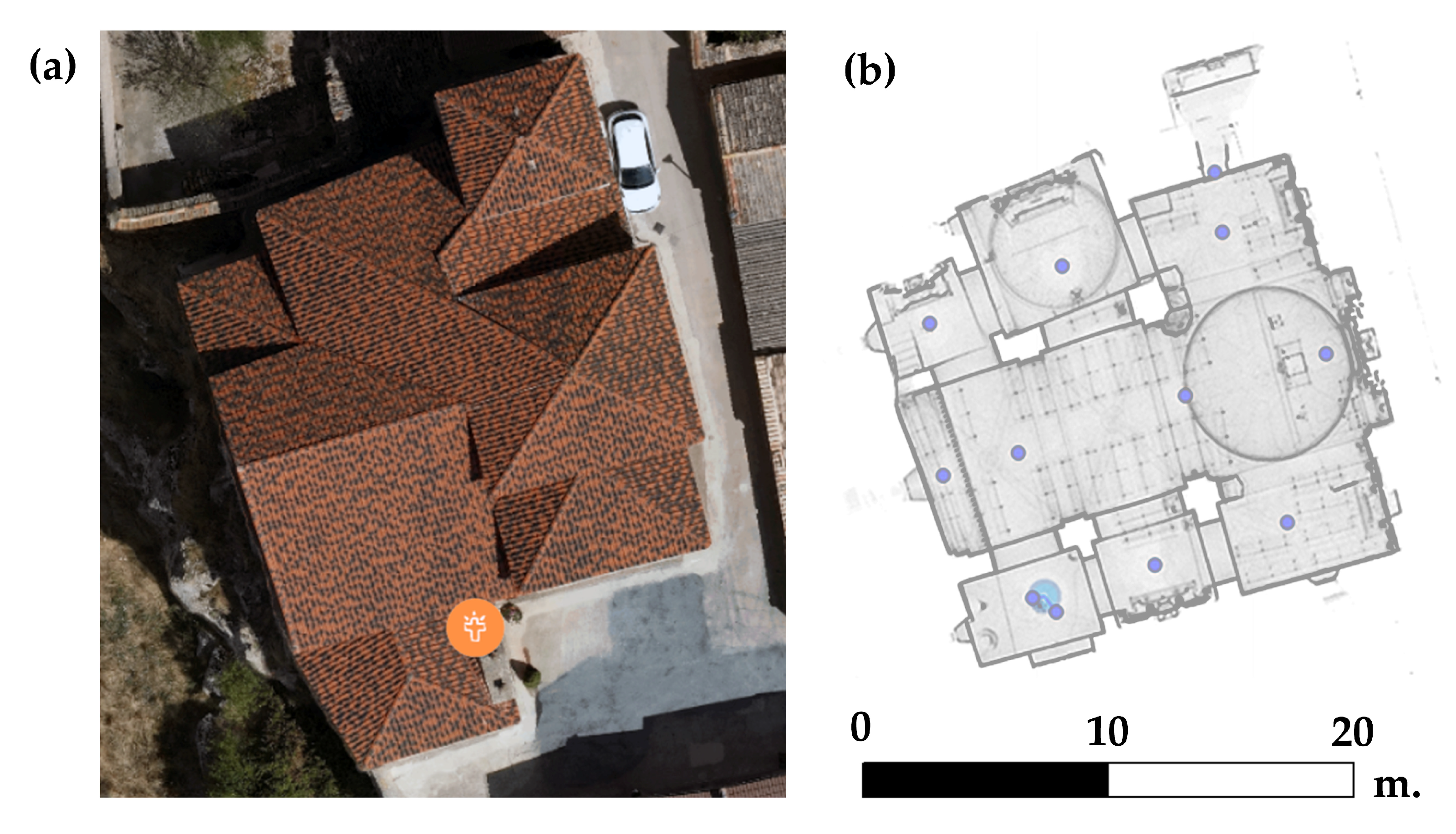
2.1. Areas and Buildings Documented in This Work

The property of cultural interest (BIC), the underground wine cellars in Atauta, comprises a total of 141 wine cellars in addition to the different types of local wine presses (“lagares” and “lagaretas”). There are also two pigeon lofts. All these elements occupy an area of 3 ha in the Paraje del Hondo. The BIC also includes singular sites and buildings such as the church, the rural school, and the house museum in the village centre, together with a forge and a municipal laundry, which are all located on the left side of the road connecting the upper part of the village with the main area of wine cellars. Table 1 shows a selection of the 63 buildings documented out of the existing 156, of which 36 have a virtual visit, 17 have a 3D model, and 48 have associated information. The Total column shows the buildings surveyed out of the total number of existing buildings.
Figure 2 shows an orthophoto with the location of each of the buildings studied in the ethnological complex of the underground cellars in Atauta, which were described in the previous section. A peculiarity of this complex is that it is surrounded by vineyards. Some of these vines are over 200 years old and therefore free from phylloxera (Daktulosphaira vitifoliae), which is a plague caused by an insect of American origin that feeds on the roots and leaves of the vines. This had devastating consequences between 1870 and 1930, and it caused the disappearance of thousands of hectares of vines in Europe [53].

2.2. Methodology Used for Documentation and Virtualisation

The methodology to obtain the documentation and virtualisation of underground wine cellars in Atauta (Soria), on both the exterior and interior of the buildings, allows for high-precision sub-metric digital visualisation (3D); this is in addition to the creation of the virtual environment described below (Figure 3).

2.3. Data Collection

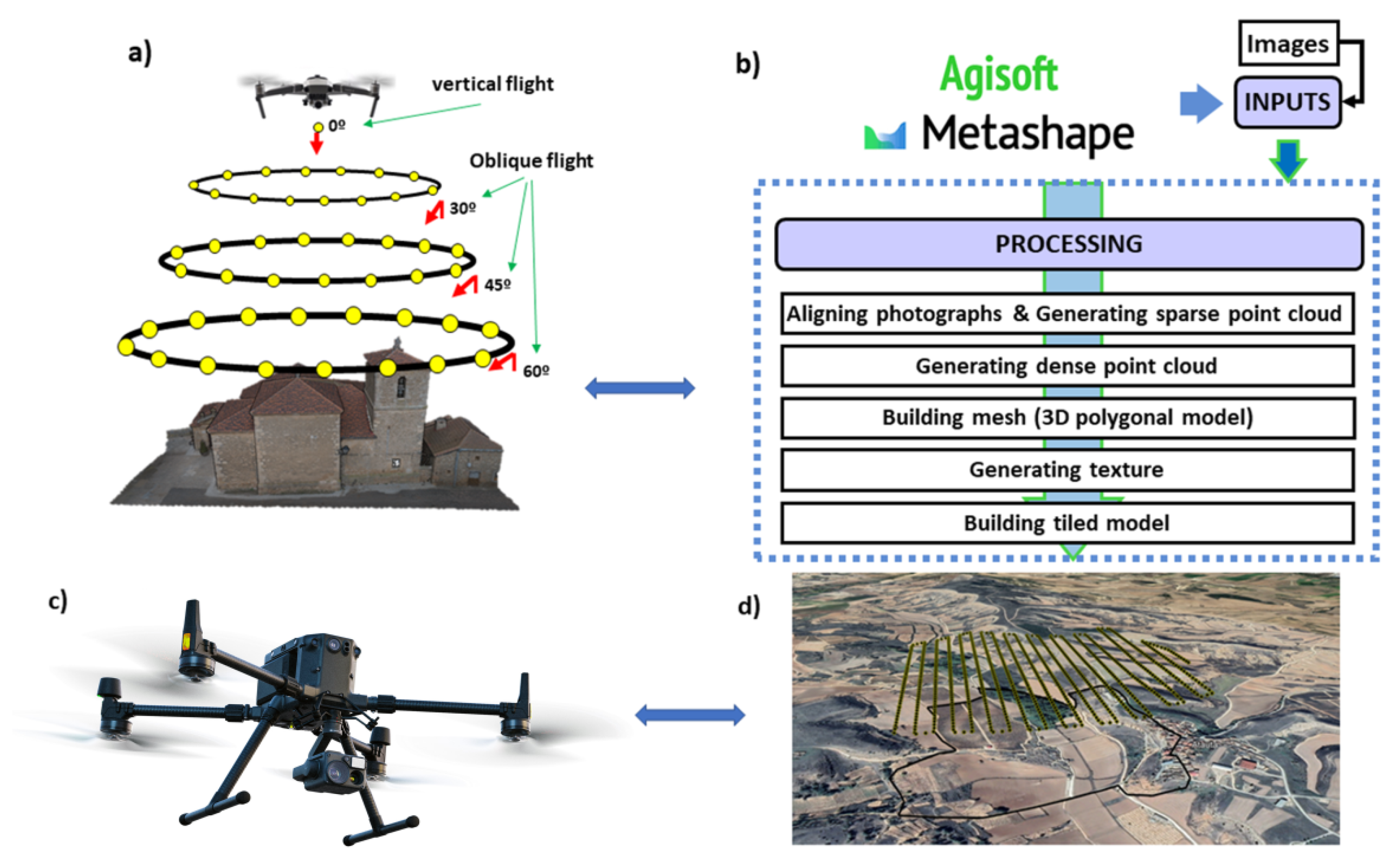
2.3.1. High-Precision Metric Documentation (in 3D)

Geometric techniques such as aerial and near-object photogrammetry with digital cameras mounted on unmanned aerial vehicles (UAVs) were used to document the exterior of underground wine cellars in Atauta. The cartography thus obtained represents the entire environment of the BIC. The final digital documentation includes the different 3D point clouds with sub-metric rigour and great detail.
Static and mobile terrestrial laser-scanning (TLS) techniques were used inside the wine cellars and other constructions to achieve the required level of detail, particularly in narrow unlit spaces. These techniques were tested previously through experimental work and prior studies [42,43,44]. Figure 4 schematically illustrates the process of geomatic data collection. Data were collected both outside and inside the ethnological site. Finally, in this phase, the data and point clouds obtained were integrated to generate high-resolution models and digital images.
  • Site exterior
Two types of UAV were used: a Matrice 300 RTK for the general mapping of the project and a Mavic 3 for capturing the details of the exterior of the constructions and spaces. The Matrice 300 RTK was connected to the National Geographic Institute’s (IGN) GNSS network in the Virtual Reference Station (VRS) solution, which provided ETRS89 UTM30N coordinates in real time with precisions of 1–2 cm in planimetry and 2–4 cm in altimetry. The orthophotograph produced with this UAV has a resolution of 2 cm and serves as a raster map for locating the most singular structures; it also contains the basic data for the global georeferencing of the project.
In addition to the previous equipment, a second Mavic 3 UAV was used with autonomous GNSS and a precision of 1–2 m in its positioning. This UAV was more manageable for flying close to the ground in order to capture the details of the walls, roofs, or under tiles, and it produced data in the form of point clouds that can be hybridised with the exterior point clouds of the TLS to obtain three-dimensional models of each construction. Table 2 shows the technical specifications of the DJI Matrice 300 RTK UAV, and Table 3 shows the technical specifications of the Mavic 3 UAV. These UAVs carry different sensors.
This way of working in the field was adapted to the type of building. In the case of the church, given its form and position, successive photographic captures were taken wherein the angle of incidence varied, as can be seen in Figure 5a. Figure 5b shows the photogrammetric processing of digital images with the Agisoft Metashape software (https://www.agisoft.com/ accessed on 8 May 2023).
The 3D documentation was produced following two approaches: on the one hand, basic geoinformation on the BIC was obtained with the Matrice 300 RTK UAV and the Zenmuse P1 camera. On the other hand, for the photogrammetric survey of the 45 ha of the BIC, 953 photographs were captured in two flights that were made following the heights of the digital terrain models and by maintaining the flight height over the steep terrain of the Atauta valley (Figure 5c,d). The processing and base orthophotograph were conducted with the DJI Terra software (https://www.dji.com/es/dji-terra accessed on 8 May 2023), and no support points were used given the high precision obtained when determining the flight photo centres with a VRS RTK solution connected to the IGN’s network of reference stations (https://www.ign.es/web/gds-gnss-estaciones-permanentes accessed on 8 May 2023).
  • Interior of the wine cellars and other buildings
The TLS used was a Faro Focus X330 (Table 4). Sweeps were made of the inside of the wine cellars and buildings and from a position on the door jamb of each element. In addition, several points on the exterior were swept in order to merge the TLS scans and the point clouds from the UAVs by processing the information from the Mavic 3 image.
The models of the wine cellars, wine tanks, and unique buildings—such as the church, laundry, etc.—were calculated with the Agisoft Metashape software until high-resolution point clouds were obtained for each element. In addition, they were registered with SCENE software (https://www.faro.com/en/Products/Software/SCENE-Software accessed on 8 May 2023), and the interior stations were represented in these same constructions (Figure 6). This hybridisation achieves a single point cloud that merges both the others and can be analysed, sectioned, and worked on with the open-source 3D cloud renderer Potree—a tool included in the GeoPortal for the analysis of 3D point clouds.

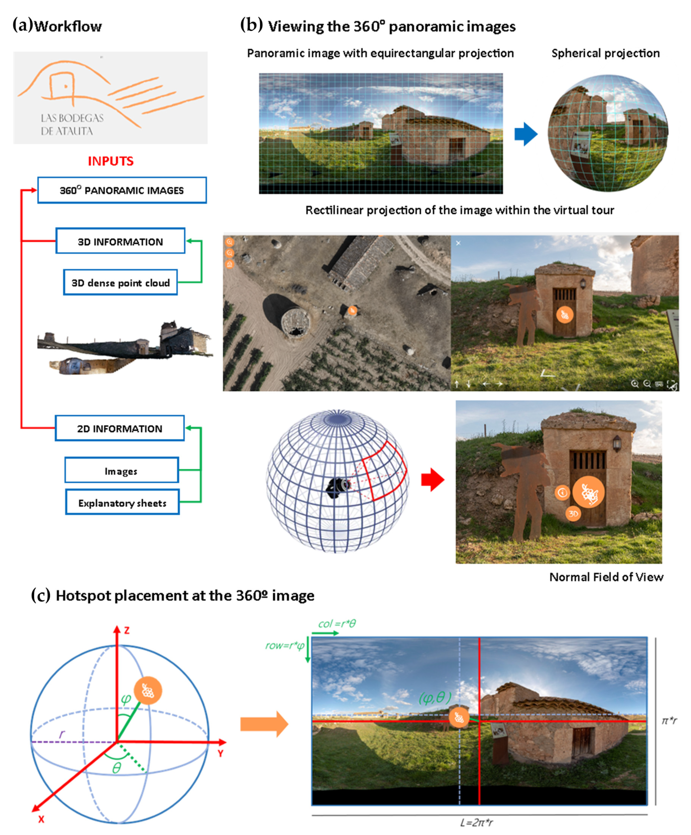
2.3.2. Taking the Panoramic Images

  • Workflow for the creation of the virtual tour
The virtual tour platform currently in use relies primarily on 360° images, which deliver a highly immersive experience at a reasonable cost. These images, shown on the platform in a spherical projection, have a unique system of coordinates in which buttons are placed at coordinates (known as hotspots) and are associated with a wide range of multi-source and multidisciplinary information at a particular position in a panorama, as determined by the angles θ and φ (Figure 7).
  • Panoramic images
After an in-depth analysis of the various methods for capturing panoramic images, it was determined that the most effective approach was to use a reflex camera and fisheye lens to take seven images (spaced at 60° intervals, including one overhead shot). One of the main benefits of using this equipment as opposed to a 360° camera (which automatically generates a panoramic image) is the enhanced quality and greater control over parameters such as ISO, exposure, and white balance. This methodology also enabled us to use the exposure bracketing option when capturing the images. Exposure variations of up to 2.0 EV can be specified when shooting with auto bracketing; thus, three images of the same scene with different exposures can be captured. This technique is particularly useful in situations where the correct exposure can be difficult to determine, such as in variable lighting conditions or high-contrast scenes. The different images can then be merged together to create a high dynamic range (HDR) photo that shows detail in both the darkest and lightest areas of the image.
A Nikon D5600 reflex camera equipped with a Nikkor 10.5 mm 1:2.8 G fisheye lens was used for this project in order to capture high-resolution (24 MPx) images. Additionally, a photographic tripod and a Manfrotto 303SPH panoramic head were required to ensure precise photographs in the angular positions of every 60° (see Figure 7). Prior to taking the photographs, it was necessary to calibrate the camera (along with the lens) on the anterior patella to align the entrance pupil with the axis of rotation of the panoramic patella and eliminate parallax. The camera’s internal settings, such as aperture, exposure time, as well as ISO and HDR mode, also needed to be configured before taking the photos.
After taking the photographs by following the shooting protocol explained in Figure 8, they were processed using Hugin open-source software (https://hugin.sourceforge.io/ accessed on 8 May 2023) as per the workflow depicted in Figure 7. The process involved extracting and matching key points between individual images using the SIFT algorithm (scale-invariant feature transform) and then registering them globally to minimise error accumulation and to optimise the camera’s distortion parameters, focal length, and angular positions [54]. Finally, the panorama was generated by projecting the images onto the spherical coordinate system via gain compensation and multi-band blending to fuse all the images correctly from a radiometric perspective [55]. A total of nine panoramas were created, and each were saved in .jpg format with a low compression ratio to avoid artifacts.
In addition, a total of 17 high-resolution panoramic images (in .tif format) were generated of the main monuments in the vernacular cultural heritage asset of the Atauta wine cellars.
Immersive digital tools that offer the experience of visiting various locations or spaces within a specific environment are commonly known as virtual tours. These tours are created by connecting a series of 360° panoramic images by means of specialised software, resulting in a complete visualisation of the space. Users can access this virtual space from any computer or mobile device with internet access, and they can enjoy a similar experience to being physically present at the location. Additional information can be incorporated into these virtual tools to enhance the user’s understanding of the environment in question [56]. The process involved in developing virtual tours is presented below.2.3.3. Information Required for Understanding the BIC
All the available information on the BIC was compiled. The existing bibliography was reviewed in order to identify and catalogue the elements of the heritage asset (building, contents, materials, landscape).
Information was collected by means of photographic registration and interviews with several local agents: residents, the priest of the church of San Pablo de Atauta, and the mayor of Atauta.
In order to disseminate the history, culture, and traditions of underground wine cellars in Atauta, a series of worksheets were created to supplement the information provided in the virtual environment. These worksheets describe the main construction characteristics, the materials used, and specific details such as the doors and their locks.

2.4. Architecture of the Virtual Platform: Platform Design, Interface, and Visualisation of Point Clouds with Potree

2.4.1. Architecture of the Virtual Platform: Platform Design and Interface

Through following the general schema (Figure 3) and the basic design of the web platform (Figure 9), the operation of the virtual platform is described below. This is a computer platform that stores data, such that it can be consulted by different users. It has a software that delivers the information requested by the visitors through a device connected to the web. Its function begins at the geoserver by launching a query in the search engines or by directly entering a web address (URL) or domain name. The server locates the content and sends it to the user’s device where it can be seen instantaneously. The server acts as a space for storing different types of information from a part of the geoserver that positions and links the HTML, CSS, and JavaScript files (including images, text, video, and audio). These routines must be located by the programs responsible for the functioning of the computer’s operating system. This is the case with PuTTY (https://www.putty.org/ accessed on 8 May 2023), which is a software used for accessing the server’s command console by means of a secure sockets layer (SSL) connection, which is also compatible with WinSCP (https://winscp.net/eng/download.php accessed on 8 May 2023) (a software for uploading files from the local computer to the server by means of FTP). The tree of these files therefore comprise all the data collected in the field, which are subsequently processed.
If a user wishes to access the website from their computer, the server launches a program to extract the information from the web page and send it to the client. The HTTP commands act as orders that allow the information to be sent from a physical server to the end user’s device, such that the information can be consulted anywhere with an internet connection without occupying the storage space of a personal computer.
In this project, we have chosen to use a type of virtual private server (VPS) managed by the Madrid Supercomputing and Visualisation Centre (CESVIMA) in the UPM, which—among its other computer resources—has the third version of the supercomputer Magerit. The advantage of VPS is that they allow the information to be managed within a specific group and can limit the access of certain users to the reserved content [48,49].
The platform has been designed such that the user can understand the underground heritage, the immaterial cultural heritage, and the cultural landscape that all converge in this ethnological site in an integrated way. This platform is programmed and designed in plain HTML, such that it can be incorporated into the reference heritage website. The URL Bodegas de Atauta can be accessed at https://www.gigesypupm.com (IP address/DNS address: 138.4.92.236/vps236.cesvima.upm.es accessed on 8 May 2023).
Access is easy and intuitive for any type of user, as they will find a base orthophotograph and a high-resolution image obtained by UAV, thereby showing a detailed view of each part of the BIC. This image is navigable and can be enlarged to examine specific details. It was previously adapted by generating the pyramids for different zoom levels from the original image and uploading these images to the server, thereby avoiding the need for a map server. The position data for the elements were integrated into coordinates, such that the exact locations of each element were included in the base maps.
Virtual visits are 360° interactive panoramic images that are placed on the orthophotograph in specific locations. The platform has an interface that allows users to select different locations from which to access the virtual visits. It also has navigation tools, such that the user can move around the study area. The platform includes additional information on each of the elements that are described in Table 1, and it offers the capacity to interact with each one (orthophotograph, 3D digital models, etc.) (Figure 9). In summary, users can launch an intuitive query of the data related with the tangible/intangible heritage of underground wine cellars in Atauta, which has evolved as a result of the practices and customs associated with the wine-producing tradition.

2.4.2. Visualisation of the Point Clouds with Potree

Potree is a free open-source WebGL-based point-cloud renderer for large point clouds.
  • Installation
A prior requirement for installing Potree is to have previously installed NodeJS10. Once this has been installed, it is downloaded from the GitHub page https://github.com/potree/potree (accessed on 8 May 2023) through git https://git-scm.com (accessed on 8 May 2023) with the clone command or by downloading the repository in .zip format. It is then introduced in the command console (Powershell or cmd in Windows). Go to the repository where the files are located and launch the command npm install to install the dependencies of package.json.
In addition to Potree, it is also necessary to install PotreeConverter to transform the point clouds into the LAS or LAZ format or into the formats that Potree requires to function. To do this, download the compressed file from the following link and extract it: https://github.com/potree/PotreeConverter/releases (accessed on 8 May 2023).
  • Visualisation of the point clouds
The first step before visualising the point cloud is to transform it into the Potree format. From the command console, access the directory where the zipped Potree Converter file was extracted. After reaching the directory containing PotreeConverter.exe, launch the following command: .\PotreeConverter.exe <Location of the las or laz file> – or <location of the output file> – p <name of the Potree page>. Then, with the command console, go to the directory containing the Potree viewer using the command npm start. Once the necessary processes in the command have been completed, go to the browser available at localhost:1234, which contains a navigation menu showing all the pages in the Potree format. If you wish to view the website of the project previously created, it is advisable to specify an output directory located within the directory at the address https://nodejs.org/es/download/25 (accessed on 8 May 2023), which contains the Potree viewer.
  • Modifications
Due to a series of requirements, the original Potree code was modified. These requirements are as follows: distribution of the Potree sidebar into two sections—advanced mode and scenes. The first mode groups all the tools and visualisation modes allowed by Potree, while the second can be used to navigate through the point clouds uploaded in the viewer. Arrange the points according to the device: depending on the device being used, the load of the points in the clouds displayed is adjusted. To fulfil the first requirement, the html code of the file src/viewer/sidebar.html was reformed. For the second requirement, a code was added to the Potree code in the src/viewer/sidebar.js file in the function innitAppearance(), which results in changes to the limits of the sldPointBudget slider depending on the device detected by the browser.

3. Results

In the development of the work of documentation and virtualisation of vernacular cultural heritage, a new web platform (Figure 10) was created that allows for the precise knowledge of each space and construction element. It is organised into sections and subsections: (a) about Atauta, the underground cellars, history of the ethnological complex, heritage values, and looking to the future; (b) virtual tour; (c) photo and video gallery; and (d) contact us. This resource is accessible to any user and allows for all types of the public to view and consult the different spaces and constructions both in person and virtually.
The web platform is designed such that any user can visualise four sections:
  • About Atauta (the Atauta wine cellars). This is a brief accompanying description as well as images of the ethnological site, heritage values, and a review of the future of this type of heritage;
  • A map base with content that is accessible by means of browser guides;
  • The possibility of taking a virtual tour. From this section, visitors can virtually visit each site by using QR codes and virtual reality (VR) glasses, or they can directly access and query/observe the different spaces in 3D or in 360° (Figure 11). This visit or query can be performed on both fixed devices (computers), mobile devices (smartphones or tablets), and on virtual reality devices. Access will be enabled by means of a keypad for intuitive browsing;
  • Collection of images and videos in a gallery. Possibility of viewing a series of images, videos, and compositions representing the BIC.
  • Other results and activities:
In addition to the fieldwork and the computer processing of the data, 11 panels have been designed, printed, and installed (DIN A1 size) as an explanatory guide to provide information on this virtual platform and on the BIC in particular. They will be displayed in the municipal laundry or in the “lagareta” adapted for this exhibition.
A QR code was designed and is being prepared for installation in each of the buildings on the Atauta site included in the project. This code is located in each of the most important spaces, such that visitors can consult the virtual information available on the website during their visit. All the QR codes are visible in a printed or virtual leaflet that visitors can use as a support guide.

4. Discussion

Both the hypothesis of this research and the integration of data from different sensors were demonstrated to be valid for generating the documentation and virtualisation of the ethnological site. As noted by [57], an accurate record of underground objects is required to ensure their presence in the property inventory. The property register should contain a record based on a detailed survey of the underground wine cellars. The inclusion of comprehensive documentation on the whole asset being linked with novel tools such as the web platform described here will enable more effective dissemination and thus will increase awareness of the importance of preserving cultural heritage.
Elbshbeshi [58] applied geomatic techniques to document heritage constructions; furthermore, TLS techniques have been employed in certain cases to establish the geometry of underground constructions [59,60,61]. This research not only uses TLS techniques but also integrates point clouds, digital models, orthophotographs, and panoramic photographs to document the different spaces and buildings in the BIC. It was decided that a reflex camera and a fisheye lens should be used for photos taken at intervals of 60°, including overhead shots. This decision was motivated by the spatial and lighting conditions in the sites represented, and it was based on several precedents that endorse the use of this methodology [62,63]. According to Barrile, a robust geometry based on oblique images from a UAV pointing at the buildings guarantees a large number of light beam intersections in the 3D space. Robust image configurations are required for projects in which precision may be a priority; this is conducted to ensure that users can enjoy an interactive, detailed, and up-to-date experience by means of immersive visualisations, thus creating the sensation of being at the site from a remote location. However, if the aim is to add more characteristics—for example, acoustic descriptors—than is provided by the tool itself, i.e., beyond graphic representation, then the usefulness of point clouds is clearly limited [64].
Other studies, such as that of Blaya [65], consider it interesting to apply modern computer tools to the management of cultural heritage. These tools enable a wider public to see sites that were previously inaccessible, and this new accessibility to the web platform will allow for the dissemination and promotion of tourism toward this less widely known vernacular heritage, which is potentially of great historical interest. In the same vein, Ducros (2017) indicates that certain rural zones have reinvigorated their territorial development through tourism, tapping into their vernacular heritage to safeguard their future. Fuentes (2010) also studies how traditional buildings in the rural environment can initiate new activities that bring benefits to the whole community.
It is advisable to assess the usability of this tool, as has been conducted in related research [66,67,68], in order to classify and quantify the possible strengths and weaknesses of this work. It would be interesting to know the specific user type, the task for which the system is designed, and the context of the interaction [69]. Budiu [70] contributes with experiences on how to design the best websites and apps for mobile devices, given that many users access this web platform from their smartphones and tablets. Finally, one method for conducting this assessment would be to create a survey containing questions on the main aspects of the BIC and to ask a sample of users to answer them.
It has been recommended to local and regional governments that they should create a centre for the interpretation of vernacular heritage. One that could accommodate the presence of different groups of people could provide an additional way in which to promote the dissemination and knowledge of the site and its traditions; rural heritage as an economic resource; the importance of cultural and architectural conservation; and the transmission of identity to future generations. Open access to the web platform will also give visibility and offer the possibility of making immersive visits to the various spaces and buildings in the BIC as well as by enabling people with limitations to benefit from and experience the sensation of being in this place from a remote location.
This methodology can be extrapolated to other projects and environments with similar characteristics. The methodology developed in this research is currently being used in the underground wine cellars in Baltanás (Palencia, Spain), which was declared an ethnological site (BIC) in 2016. The rapid development of artificial intelligence (AI) is opening up a new path through which to improve and optimise the procedures applied in this research.

5. Conclusions

The underground wine cellars in Atauta (Soria) represent a unique testimony of the life that is associated with work on the land as well as the traditional system of wine production. It is important to ensure they are not forgotten and destroyed, as they are a manifestation of Spain’s cultural identity—specifically, in this case, the heritage in the Duero basin.
Several generations of the people who conceived and built these sites are already gone, and their departure symbolises a profound loss of knowledge that is difficult to recover. These types of applications and technological resources can partially supplement this absence. Digital twins and digital models in general can respond to the challenges that will arise in the immediate future for the documentation and virtualisation of this type of vernacular heritage.
These models can generate different scenarios based on a spatial reconstruction in a virtual environment that is different from the real one. Artificial intelligence applications can generate a large response capacity and allow for the development and testing of hypotheses that can be revised at any time based on the data from subsequent research.
Managers, local communities, policymakers, and the general public must share in the common objectives for the defence and use of vernacular heritage.

Author Contributions

Conceptualisation, T.R.H.-T., M.Á.M.-G. and E.P.-M.; data curation, M.Á.M.-G., S.L.-C., J.L.d.H., L.J.S.-A., and P.V.L.; formal analysis, E.P.-M., S.L.-C., J.L.d.H. and P.V.L.; funding acquisition, T.R.H.-T. and M.Á.M.-G.; investigation, T.R.H.-T. and L.J.S.-A.; methodology, T.R.H.-T., M.Á.M.-G. and S.L.-C.; project administration, T.R.H.-T. and M.Á.M.-G.; resources, E.P.-M., S.L.-C., J.L.d.H., L.J.S.-A. and P.V.L.; software, M.Á.M.-G., E.P.-M., S.L.-C., L.J.S.-A. and P.V.L.; supervision, M.Á.M.-G. and S.L.-C.; validation, T.R.H.-T., E.P.-M., S.L.-C. and J.L.d.H.; visualisation, E.P.-M., J.L.d.H. and P.V.L.; writing—original draft, T.R.H.-T. and E.P.-M.; writing—review and editing, T.R.H.-T., M.Á.M.-G. and E.P.-M. All authors have read and agreed to the published version of the manuscript.

Funding

This research was funded from the Comunidad de Castilla y León (Spain). Reference: MID/2021-050. And by the project LABPA-CM: CONTEMPORARY CRITERIA, METHODS AND TECHNIQUES FOR LANDSCAPE KNOWLEDGE AND CONSERVATION (H2019/HUM5692), funded by the European Social Fund and the Madrid Regional Government.

Data Availability Statement

The data presented in this study are available on request from the corresponding author.

Acknowledgments

We would like to thank the Atauta Town Hall (San Esteban de Gormaz) and the companies FARO SPAIN S.L.U. and Grupo ACRE SPAIN for their help with the cultural landscape, including administrative and technical support (materials used for experiments). The grant RYC2021-034813-I funded by MCIN/AEI/10.13039/501100011033 and the European Union “NextGenerationEU”/PRTR has been awarded to M.Á.M.-G. We also wish to acknowledge Pru Brooke-Turner (M.A. Cantab.) for her English language and style review.

Conflicts of Interest

The authors declare no conflict of interest.

References

  1. Yang, F.; Wang, J.-B.; Zhang, H.; Lin, M.; Cheng, J. Multi-IRS-Assisted mmWave MIMO Communication Using Twin-Timescale Channel State Information. IEEE Trans. Commun. 2022, 70, 6370–6384. [Google Scholar] [CrossRef]
  2. Aheleroff, S.; Xu, X.; Zhong, R.Y.; Lu, Y. Digital Twin as a Service (DTaaS) in Industry 4.0: An Architecture Reference Model. Adv. Eng. Inform. 2021, 47, 101225. [Google Scholar] [CrossRef]
  3. Eppich, R.; Ramku, B.; Binakaj, N. The National Library of Kosovo “Pjeter Bogdani” Rapid Condition Assessment and Documentation. Int. Arch. Photogramm. Remote Sens. Spatial Inf. Sci. 2017, XLII-2/W5, 215–219. [Google Scholar] [CrossRef] [Green Version]
  4. Lowenthal, D. The Past Is a Foreign Country-Revisited; Cambridge University Press: Cambridge, UK, 2015. [Google Scholar]
  5. Spennemann, D.H. Beyond “Preserving the Past for the Future”: Contemporary Relevance and Historic Preservation. CRM J. Herit. Steward 2011, 8, 7–22. [Google Scholar]
  6. De la Torre, M. Values and heritage conservation. Herit. Soc. 2013, 6, 155–166. [Google Scholar] [CrossRef]
  7. Canizaro, V.B. Architectural Regionalism: Collected Writings on Place, Identity, Modernity, and Tradition; Princeton Architectural Press: Hudson, NY, USA, 2007. [Google Scholar]
  8. Zwerger, K. Vernacular Architecture: A Term Denoting and Transporting Diverse Content. Built Herit. 2019, 3, 14–25. [Google Scholar] [CrossRef]
  9. Asquith, L.; Vellinga, M. Vernacular Architecture in the 21st Century: Theory, Education and Practice; Taylor & Francis: Abingdon, UK, 2006. [Google Scholar]
  10. Pardo, J.M.F.; Guerrero, I.C. Subterranean wine cellars of Central-Spain (Ribera de Duero): An underground built heritage to preserve. Tunn. Undergr. Space Technol. 2006, 21, 475–484. [Google Scholar] [CrossRef]
  11. Ballantyne, A. Rural and Urban: Architecture between Two Cultures; Routledge: Abingdon, UK, 2009. [Google Scholar]
  12. Lutz, H.F. Viticulture and Brewing in the Ancient Orient; J.C. Hinrich: New York City, NY, USA, 1922. [Google Scholar]
  13. Sardaro, R.; La Sala, P.; De Pascale, G.; Faccilongo, N. The conservation of cultural heritage in rural areas: Stakeholder preferences regarding historical rural buildings in Apulia, southern Italy. Land Use Policy 2021, 109, 105662. [Google Scholar] [CrossRef]
  14. Ganem, C.; Coch Roura, H. An environmental review of wineries over the last centuries: From vernacular to high tech. In Proceedings of the PLEA2012-28th Conference, Opportunities, Limits & Needs towards an Environmentally Responsible Architecture, Lima, Perú, 7–9 November 2012. [Google Scholar]
  15. Barbero-Barrera, M.M.; Gil-Crespo, I.J.; Maldonado-Ramos, L. Historical development and environment adaptation of the traditional cave-dwellings in Tajuna’s valley, Madrid, Spain. Build. Environ. 2014, 82, 536–545. [Google Scholar] [CrossRef]
  16. Conejo Martín, M.Á.; Ezquerra Canalejo, A.; Herrero Tejedor, T.R. Propuesta Metodológica para el Estudio de Sistemas Topográficos Aplicados a la Representación Gráfica de Bodegas Subterráneas Tradicionales. Ph.D. Thesis, Tesis-Universidad Politécnica de Madrid E T S I Agrónomos, M.A. Conejo, Madrid, Spain, 2014. [Google Scholar]
  17. Nocera, F.; Caponetto, R.; Giuffrida, G.; Detommaso, M. Energetic Retrofit Strategies for Traditional Sicilian Wine Cellars: A Case Study. Energies 2020, 13, 3237. [Google Scholar] [CrossRef]
  18. Diogo, M.; Diogo, M.; Diogo, J.; a Diogo, P. The Underground Architecture. Int. J. Eng. Res. Technol. (IJERT) 2019, 8, 310–314. [Google Scholar] [CrossRef]
  19. Camarero, L. Por los senderos de la despoblación rural. Doc. Soc. 2017, 185, 19–35. [Google Scholar]
  20. Urrestarazu, E.R. Patrimonio rural y políticas europeas. Lurralde Investig. Y Espac. 2001, 24, 305–314. [Google Scholar]
  21. Fuentes, J.M.; Gallego, E.; Garcia, A.I.; Ayuga, F. New uses for old traditional farm buildings: The case of the underground wine cellars in Spain. Land Use Policy 2010, 27, 738–748. [Google Scholar] [CrossRef]
  22. Cuerva, E.; Urbano, J.; Cornado, C. Recovering Industrial Heritage: Restoration of the Wine Cellar Cooperative in Falset (Catalonia, Spain). Buildings 2019, 9, 243. [Google Scholar] [CrossRef] [Green Version]
  23. Pla, J.H.; García, E.I. El patrimonio rural como factor de desarrollo endógeno. Saitabi 2015, 54, 9–24. [Google Scholar]
  24. Vinuesa, M.Á.T. Territorio, patrimonio y paisaje: Desafíos de una ordenación y gestión inteligentes. Ciudad Y Territ. Estud. Territ. 2011, XLIII, 561–569. [Google Scholar]
  25. Mazaira, J. Valdeorras, tierra de vinos. In III Congreso internacional de Barrios Históricos de Bodegas; Actas: Tokyo, Japan, 2022; pp. 103–108. [Google Scholar]
  26. Rodriguez-Gonzalvez, P.; Mancera-Taboada, J.; Gonzalez-Aguilera, D.; Munoz-Nieto, A.; Armesto, J. A Hybrid Approach to Create an Archaeological Visualization System for a Palaeolithic Cave. Archaeometry 2012, 54, 565–580. [Google Scholar] [CrossRef]
  27. Alberto Torres, J.; Hernandez-Lopez, D.; Gonzalez-Aguilera, D.; Moreno Hidalgo, M.A. A hybrid measurement approach for archaeological site modelling and monitoring: The case study of Mas D’Is, Penaguila. J. Archaeol. Sci. 2014, 50, 475–483. [Google Scholar] [CrossRef]
  28. Escarcena, F.J.C.; de Castro, E.M.; García, J.L.P.; Calvache, A.M.; del Castillo, T.F.; García, J.D.; Cámara, M.A.U.; Armenteros, J.C.C. Técnicas fotogramétricas y de escáner láser terrestre aplicadas a la documentación y valoración del patrimonio histórico. In Catastro: Formación, Investigación y Empresa: Selección de Ponencias del I Congreso Internacional Sobre Catastro Unificado y Multipropósito; Universidad de Jaén: Jaén, Spain, 2010; pp. 459–470. [Google Scholar]
  29. Charter, L. For the Computer-Based Visualisation of Cultural Heritage; Routledge: London, UK, 2009; ISBN 9781315599366. [Google Scholar]
  30. Carrillo Gea, J.M.; Toval, A.; Fernández Alemán, J.L.; Nicolás, J.; Flores, M. The London Charter and the Seville Principles as sources of requirements for e-archaeology systems development purposes. Virtual Archaeol. Rev. 2013, 4, 205–211. [Google Scholar] [CrossRef] [Green Version]
  31. Vayanou, M.; Katifori, A.; Chrysanthi, A.; Antoniou, A. Cultural Heritage and Social Experiences in the Times of COVID 19. In Proceedings of the AVI²CH@ AVI, Ischia, Italy, 29 September 2020. [Google Scholar]
  32. López-Menchero Bendicho, V.M.; Flores Gutiérrez, M.; Vincent, M.L.; Grande León, A. Digital heritage and virtual archaeology: An approach through the framework of international recommendations. In Mixed Reality and Gamification for Cultural Heritage; Springer: Berlin/Heidelberg, Germany, 2017; pp. 3–26. [Google Scholar]
  33. Borin, E.; Donato, F. What is the legacy of the European Year of Cultural Heritage? A long way from cultural policies towards innovative cultural management models. Eur. J. Cult. Manag. Policy 2020, 10, 4–20. [Google Scholar] [CrossRef]
  34. Herrero Tejedor, T.R. Tecnologías geoespaciales aplicadas a la documentación de paisajes culturales. In Paisajes Culturales: Técnicas Contemporáneas de Documentación, Interpretación e Intervención; E.T.S. de Ingeniería Agronómica, Alimentaria y de Biosistemas (UPM): Madrid, Spain, 2019. [Google Scholar]
  35. Portalés, C.; Casas, S.; Alonso-Monasterio, P.; Viñals, M.J. Multi-dimensional acquisition, representation, and interaction of cultural heritage tangible assets: An insight on tourism applications. In Handbook of Research on Technological Developments for Cultural Heritage and eTourism Applications; IGI Global: Hershey, PA, USA, 2018; pp. 72–95. [Google Scholar]
  36. Bacca, J.; Baldiris, S.; Fabregat, R.; Graf, S.; Kinshuk, G. Augmented Reality Trends in Education: A Systematic Review of Research and Applications. Educ. Technol. Soc. 2014, 17, 133–149. [Google Scholar]
  37. Cipresso, P.; Giglioli, I.A.C.; Raya, M.A.; Riva, G. The past, present, and future of virtual and augmented reality research: A network and cluster analysis of the literature. Front. Psychol. 2018, 9, 2086. [Google Scholar] [CrossRef] [PubMed] [Green Version]
  38. Lo Cicero, G.; Seidita, V.; Vitella, M.; Alba, E.; Gaitan, M.; Sebastian, J.; Fernandez, M.; Portales, C. Recovering Sicilian Silk Heritage through Digital Technologies: The Case of Piraino’s Collection. Heritage 2022, 5, 4245–4266. [Google Scholar] [CrossRef]
  39. Akca, D.; Gruen, A. Generalized least squares multiple 3D surface matching. IAPRS 2007, 36, W52. [Google Scholar]
  40. Ahmadabadian, A.H.; Robson, S.; Boehm, J.; Shortis, M.; Wenzel, K.; Fritsch, D. A comparison of dense matching algorithms for scaled surface reconstruction using stereo camera rigs. ISPRS J. Photogramm. Remote Sens. 2013, 78, 157–167. [Google Scholar] [CrossRef]
  41. Bolognesi, M.; Furini, A.; Russo, V.; Pellegrinelli, A.; Russo, P. Accuracy of cultural heritage 3D models by RPAS and terrestrial photogrammetry. Int. Arch. Photogramm. Remote Sens. Spat. Inf. Sci. 2014, 40, 113. [Google Scholar] [CrossRef] [Green Version]
  42. Angel Conejo-Martin, M.; Ramon Herrero-Tejedor, T.; Perez-Martin, E.; Lapazaran-Izargain, J.; Otero-Garcia, J.; Francisco Prieto-Morin, J.; Velasco-Gomez, J.; PardoIguzquiza, E.; GuardiolaAlbert, C.; Heredia, J.; et al. Characterization of Underground Cellars in the Duero Basin by GNSS, LIDAR and GPR Techniques. In Mathematics of Planet Earth; Springer: Berlin/Heidelberg, Germany, 2014; pp. 277–280. [Google Scholar] [CrossRef] [Green Version]
  43. Lopez-Cuervo Medina, S.; Perez-Martin, E.; Herrero Tejedor, T.R.; Prieto, J.F.; Velasco, J.; Conejo Martin, M.A.; Ezquerra-Canalejo, A.; Aguirre de Mata, J. Assessment of DSMs Using Backpack-Mounted Systems and Drone Techniques to Characterise Ancient Underground Cellars in the Duero Basin (Spain). Sensors 2019, 19, 5352. [Google Scholar] [CrossRef] [Green Version]
  44. Herrero, T.; Perez-Martin, E.; Conejo-Martin, M.A.; de Herrera, J.L.; Ezquerra-Canalejo, A.; Velasco-Gomez, J. Assessment of underground wine cellars using geographic information technologies. Surv. Rev. 2015, 47, 202–210. [Google Scholar] [CrossRef] [Green Version]
  45. Heipke, C. Automation of interior, relative, and absolute orientation. ISPRS J. Photogramm. Remote Sens. 1997, 52, 1–19. [Google Scholar] [CrossRef]
  46. Khalloufi, H.; Azough, A.; Ennahnahi, N.; Kaghat, F.Z. Low-cost terrestrial photogrammetry for 3d modeling of historic sites: A case study of the Marinids’ Royal Necropolis city of Fez, Morocco. Mediterr. Archaeol. Archaeom. 2020, 20, 257–272. [Google Scholar]
  47. Remondino, F. Heritage Recording and 3D Modeling with Photogrammetry and 3D Scanning. Remote Sens. 2011, 3, 1104–1138. [Google Scholar] [CrossRef] [Green Version]
  48. Barrile, V.; Fotia, A.; Bernardo, E.; Candela, G. Geomatics techniques for submerged heritage: A mobile app for tourism. WSEAS Trans. Environ. Dev. 2020, 16, 586–597. [Google Scholar] [CrossRef]
  49. Barrile, V.; Bernardo, E.; Fotia, A.; Bilotta, G. Integration of Laser Scanner, Ground-Penetrating Radar, 3D Models and Mixed Reality for Artistic, Archaeological and Cultural Heritage Dissemination. Heritage 2022, 5, 1529–1550. [Google Scholar] [CrossRef]
  50. Mate-Gonzalez, M.A.; Rodriguez-Hernandez, J.; Saez Blazquez, C.; Troitino Torralba, L.; Sanchez-Aparicio, L.J.; Fernandez Hernandez, J.; Herrero Tejedor, T.R.; Fabian Garcia, J.F.; Piras, M.; Diaz-Sanchez, C.; et al. Challenges and Possibilities of Archaeological Sites Virtual Tours: The Ulaca Oppidum (Central Spain) as a Case Study. Remote Sens. 2022, 14, 524. [Google Scholar] [CrossRef]
  51. Napolitano, R.K.; Scherer, G.; Glisic, B. Virtual tours and informational modeling for conservation of cultural heritage sites. J. Cult. Herit. 2018, 29, 123–129. [Google Scholar] [CrossRef]
  52. Hua, L.; Chen, C.; Fang, H.; Wang, X. 3D documentation on Chinese Hakka Tulou and Internet-based virtual experience for cultural tourism: A case study of Yongding County, Fujian. J. Cult. Herit. 2018, 29, 173–179. [Google Scholar] [CrossRef]
  53. Agarwal, A.; Cunningham, J.; Valenzuela, I.; Bayat, F.; Bayat-Monfared, A.; Reza-Jahansooz, M.; Terol-Esparza, E.; Keshavarzi, A.; Giménez-Morera, A.; Pulido-Fernández, M. La Plaga que Cambió el Mapa del Viñedo en España; Museo Nacional de Ciencias Naturales: Madrid, Spain, 2018. [Google Scholar]
  54. Brown, M.; Lowe, D.G. Automatic panoramic image stitching using invariant features. Int. J. Comput. Vis. 2007, 74, 59–73. [Google Scholar] [CrossRef] [Green Version]
  55. Xiao, J.; Gerke, M.; Vosselman, G. Automatic Detection of Buildings with Rectangular Flat Roofs from Multi-View Oblique Imagery. In Proceedings of the ISPRS Technical Commission III Symposium: Photogrammetry Computer Vision and Image Analysis, Saint Mandé, France, 1–3 September 2010; Volume 38, pp. 251–256. [Google Scholar]
  56. Kyrlitsias, C.; Christofi, M.; Michael-Grigoriou, D.; Banakou, D.; Ioannou, A. A Virtual Tour of a Hardly Accessible Archaeological Site: The Effect of Immersive Virtual Reality on User Experience, Learning and Attitude Change. Front. Comput. Sci. 2020, 2, 23. [Google Scholar] [CrossRef]
  57. Bieda, A.; Bydlosz, J.; Warchol, A.; Balawejder, M. Historical Underground Structures as 3D Cadastral Objects. Remote Sens. 2020, 12, 1547. [Google Scholar] [CrossRef]
  58. Elbshbeshi, A.; Gomaa, A.; Mohamed, A.; Othman, A.; Ibraheem, I.M.; Ghazala, H. Applying Geomatics Techniques for Documenting Heritage Buildings in Aswan Region, Egypt: A Case Study of the Temple of Abu Simbel. Heritage 2023, 6, 742–761. [Google Scholar] [CrossRef]
  59. Porras-Amores, C.; Mazarron, F.R.; Canas, I.; Saez, P.V. Terrestial laser scanning digitalization in underground constructions. J. Cult. Herit. 2019, 38, 213–220. [Google Scholar] [CrossRef]
  60. Rodriguez-Gonzalvez, P.; Munoz-Nieto, A.; Gozalo-Sanz, I.; Mancera-Taboada, J.; Gonzalez-Aguilera, D.; Carrasco-Morillo, P. Geomatics and Geophysics Synergies to Evaluate Underground Wine Cellars. Int. J. Archit. Herit. 2014, 8, 537–555. [Google Scholar] [CrossRef]
  61. Gallay, M.; Kanuk, J.; Hochmuth, Z.; Meneely, J.D.; Hofierka, J.; Sedlak, V. Large-scale and high-resolution 3-D cave mapping by terrestrial laser scanning: A case study of the Domica Cave, Slovakia. Int. J. Speleol. 2015, 44, 277–291. [Google Scholar] [CrossRef] [Green Version]
  62. Cauwerts, C.; Jost, S.; Deroisy, B. Calibration of high dynamic range images for applied color and lighting research. J. Opt. Soc. Am. A-Opt. Image Sci. Vis. 2019, 36, C130–C142. [Google Scholar] [CrossRef] [PubMed]
  63. Nagle-McNaughton, T.; Cox, R. Measuring Change Using Quantitative Differencing of Repeat Structure-from-Motion Photogrammetry: The Effect of Storms on Coastal Boulder Deposits. Remote Sens. 2020, 12, 42. [Google Scholar] [CrossRef] [Green Version]
  64. Bergerot, L.; Blaise, J.-Y.; Dudek, I.; Pamart, A.; Aramaki, M.; Fargeot, S.; Kronland-Martinet, R.; Vidal, A.; Ystad, S. Combined Web-Based Visualisation of 3D Point Clouds and Acoustic Descriptors: An Interdisciplinary Challenge. Heritage 2022, 5, 3819–3845. [Google Scholar] [CrossRef]
  65. Blaya, F.; Nuere, S.; Islan, M.; Reyes-Tellez, F. Scanning application for the study, preservation and exploitation of heritage tourism: A case study of a set of underground cellars-declared Spanish good of cultural interest (BIC). Arte Individuo Y Soc. 2017, 29, 167–180. [Google Scholar] [CrossRef] [Green Version]
  66. Szekely, D.; Vert, S.; Rotaru, O.; Andone, D. Usability Evaluation with Eye Tracking: The Case of a Mobile Augmented Reality Application with Historical Images for Urban Cultural Heritage. Heritage 2023, 6, 3256–3270. [Google Scholar] [CrossRef]
  67. Vert, S.; Andone, D.; Ternauciuc, A.; Mihaescu, V.; Rotaru, O.; Mocofan, M.; Orhei, C.; Vasiu, R. User Evaluation of a Multi-Platform Digital Storytelling Concept for Cultural Heritage. Mathematics 2021, 9, 2678. [Google Scholar] [CrossRef]
  68. Russo, P.; Caponi, A.; Leuti, M.; Bianchi, G. A Web Platform for Integrated Vulnerability Assessment and Cyber Risk Management. Information 2019, 10, 242. [Google Scholar] [CrossRef] [Green Version]
  69. Sánchez, W.O. La usabilidad en Ingeniería de Software: Definición y características. Ing-Novación 2015, 2, 7–22. [Google Scholar]
  70. Budiu, R.; Nielsen, J. Mobile usability. Für Iphone Ipad. In Android, Kindle (mitp Business); MITP Verlags GmbH & Co. KG: München, Germany, 2012; ISBN 978-3-8266-9503-2. [Google Scholar]
Figure 1. (a) Location of the province of Soria in the Autonomous Region of Castilla y León (Spain). (b) Location of Atauta in the municipality of San Esteban de Gormaz (Soria). (c) Map showing the ethnological site of Atauta. The arrow indicates the exact location from which the photograph in this section was taken. (d) The photograph shows a part of the ethnological site of Atauta, with the subterranean cellars in the foreground, a vineyard, and cereal croplands in the valley next to the village itself in the upper part.
Heritage 06 00273 g001
Figure 2. Position of the buildings studied in the ethnological site of underground wine cellars in Atauta.
Heritage 06 00273 g002
Figure 3. Overview (scheme) of the general methodology used in the project.
Heritage 06 00273 g003
Figure 4. Data collected from the exterior and interior of the underground wine cellars.
Heritage 06 00273 g004
Figure 5. Type of UAV used in this project: (a) a DJI Mavic 3 was used for the photogrammetric surveys of buildings. (b) The processing of the images was obtained from the photogrammetric survey with the DJI Mavic 3. (c) The images, video, and orthophotos of the underground wine cellars were captured with a DJI Matrice 300 RTK. (d) The planning of the passes made by the UAV DJI Matrice 300.
Heritage 06 00273 g005
Figure 6. Laser-scanning methodology used: (a) Aerial view of the church. (b) Location of the TLS base points used for scanning the church.
Heritage 06 00273 g006
Figure 7. Data collected from the exterior and interior of the singular buildings. Virtual tour: (a) Information about the virtual tour. (b) Visualisation of the panoramas included in the virtual visit. (c) Positioning of the information in the panoramas.
Heritage 06 00273 g007
Figure 8. Protocol for collecting data and processing the photographs to obtain panoramic images.
Heritage 06 00273 g008
Figure 9. Basic design of the web platform. The virtual private server (VPS) stores the information and communicates with the users by providing the requested service, such as orthophotograph, 3D visualisations, etc.
Heritage 06 00273 g009
Figure 10. Web platform comprising an associated database that allows 360°, 3D, and immersive visualisation at different points of the ethnological complex and in the exterior/interior.
Heritage 06 00273 g010
Figure 11. Configuration of the web platform: (a) Parish church access to virtual visit, 360° and 3D. (b) Pigeon loft. (c) Small museum. (d) Exterior of the underground cellars represented with the Potree® 3D software, which is available on the web platform. (e) Exterior of the laundry, stone fountain, cattle trough, and municipal forge. (f) Interior of the rural school.
Heritage 06 00273 g011
Table 1. Types of buildings investigated and technologies applied.
BuildingTotalVirtual Tour3D ModelInformation
Rural school1/1111
Parish church1/1111
Small museum1/1111
Municipal laundry1/1111
Village forge1/1111
Pigeon loft½111
Local wine cellars6/8666
Underground cellars51/14124536
Total63/156361748
Table 2. Basic characteristics of the UAV DJI Matrice 300 RTK.
Matrice 300 RTK
WeightApprox. 6.3 kg
Max. transmitting distance (Europe)8 km
Max. flight time43 min
Dimensions810 × 670 × 430 mm
Max. payload2.7 kg
Max. speed20 m/seg
GNSS systemGPS + GLONASS + BeiDou + Galileo
Accuracy in hovering flight (P mode, with GNSS)Vertical:
±0.1 m (vision system activated)
±0.5 m (GPS activated)
±0.1 m (RTK activated)
Horizontal:
±0.3 m (vision system on)
±1.5 m (GPS on)
±0.1 m (RTK activated)
RTK positioning accuracyWith RTK activated and locked:
1 cm + 1 ppm (horizontal)
1.5 cm + 1 ppm (vertical)
Zenmuse P1
Weight787 g
Dimensions198 × 166 × 129 mm
Focal length35 mm
CMOS sensor size (full frame)35.9 × 24 mm
Number of effective pixels45 Mpx
Pixel size4 µm
Resolution8192 × 5460 pix
Table 3. Basic characteristics of the UAV Mavic 3.
Mavic 3
WeightApprox. 895gr
Max. transmitting distance (Europe)8 km
Max. flight time43 min
Dimensions347.5 × 283 × 107.7 mm
Max. speed15 m/seg
GNSS systemGPS + GLONASS + BeiDou + Galileo
Accuracy in hovering flight (P mode, with GNSS)Vertical:
±0.1 m (vision system activated)
±0.5 m (GPS activated)
Horizontal:
±0.3 m (vision system on)
±0.5 m (GPS on)
Hasselblad P1
WeightDrone integrated
Field of view84”
Focal length10 mm (24 mm equivalent)
CMOS sensor size (4/3)12.825 × 8.55 mm
Number of effective pixels20 Mpx
Pixel size2.3 µm
Resolution5472 × 3648 pix
Table 4. Specifications of the TLS Faro Focus X330.
SpecificationValue
Laser-Scanning Range0.6~330 m
Output Data Rate976,000 pts/s
Vertical FOV0–180°
Horizontal FOV0–360°
Laser-Scanning Angle Accuracy0.01°
Laser-Scanning Accuracy±2 mm
Camera ResolutionUp to 70 Mpx (360°)
Disclaimer/Publisher’s Note: The statements, opinions and data contained in all publications are solely those of the individual author(s) and contributor(s) and not of MDPI and/or the editor(s). MDPI and/or the editor(s) disclaim responsibility for any injury to people or property resulting from any ideas, methods, instructions or products referred to in the content.

