
Assessment and Mitigation of the Fire Vulnerability and Risk in the Historic City Centre of Aveiro, Portugal


Abstract
:1. Introduction
2. Methodological Framework
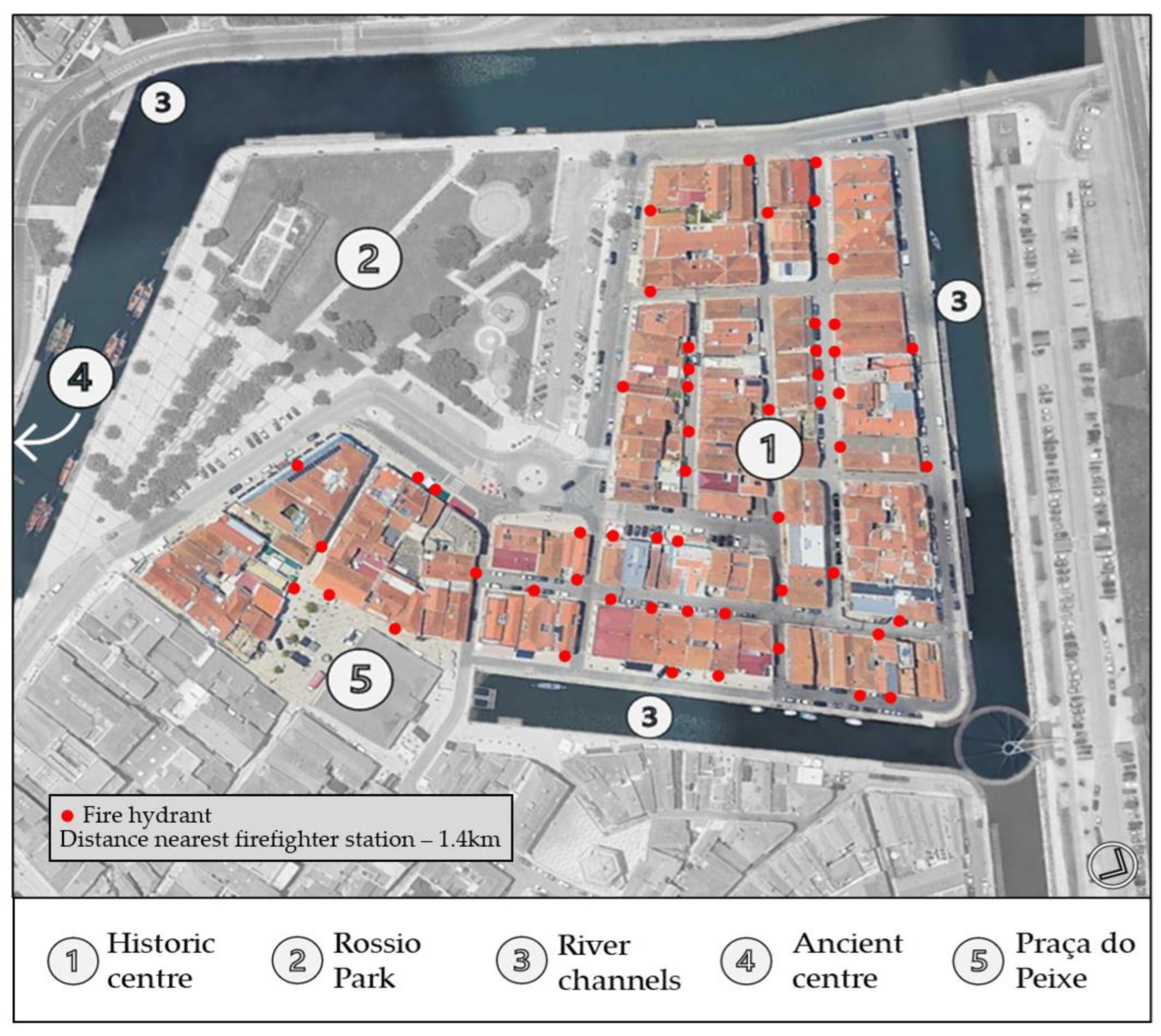
2.1. Study Area and Field Survey
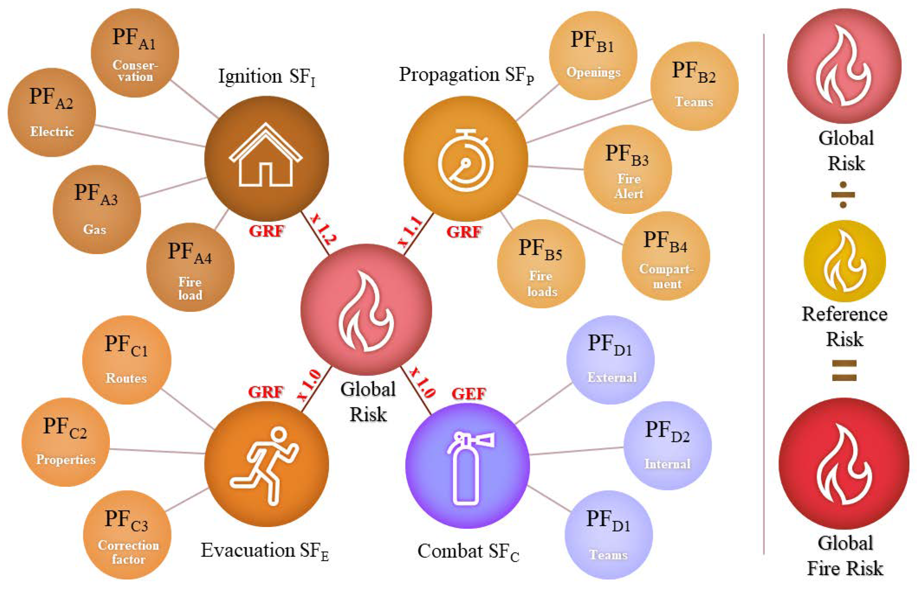
2.2. Description of the Fire Risk Assessment Method
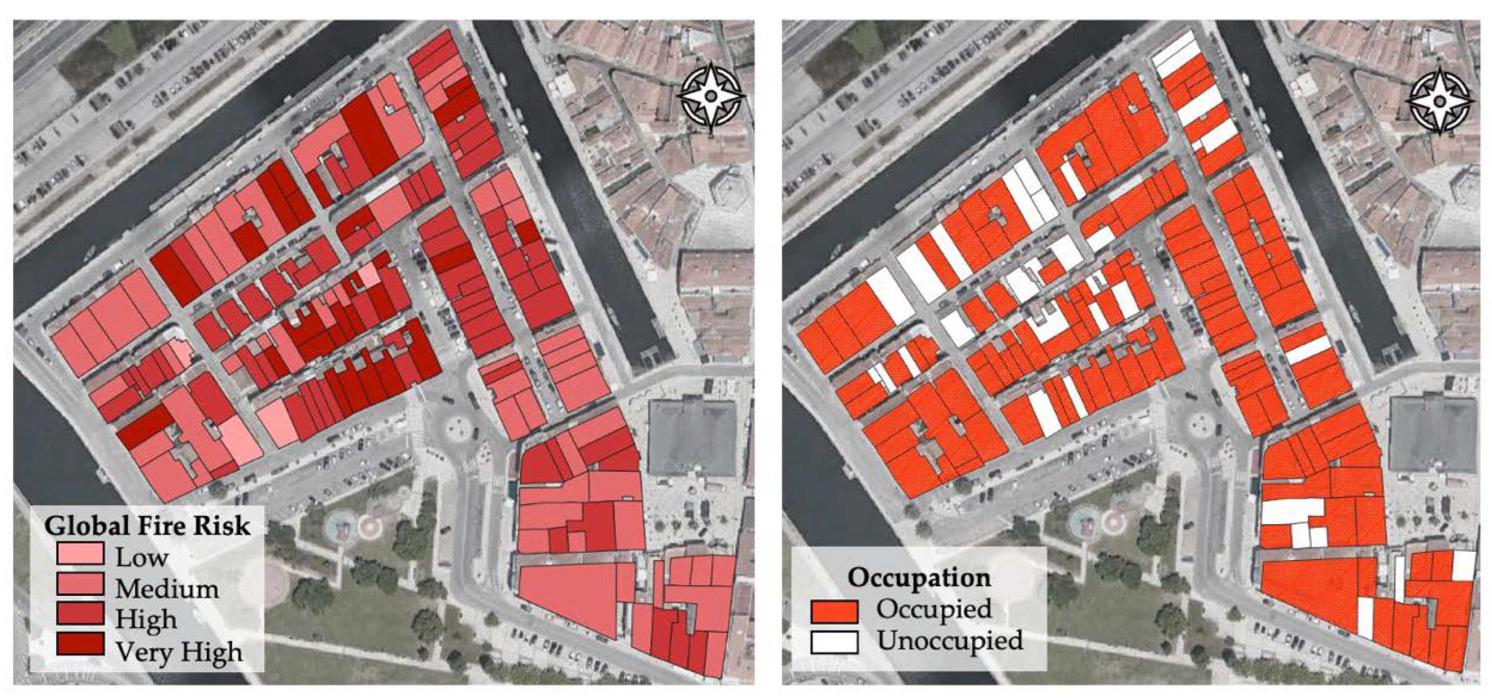
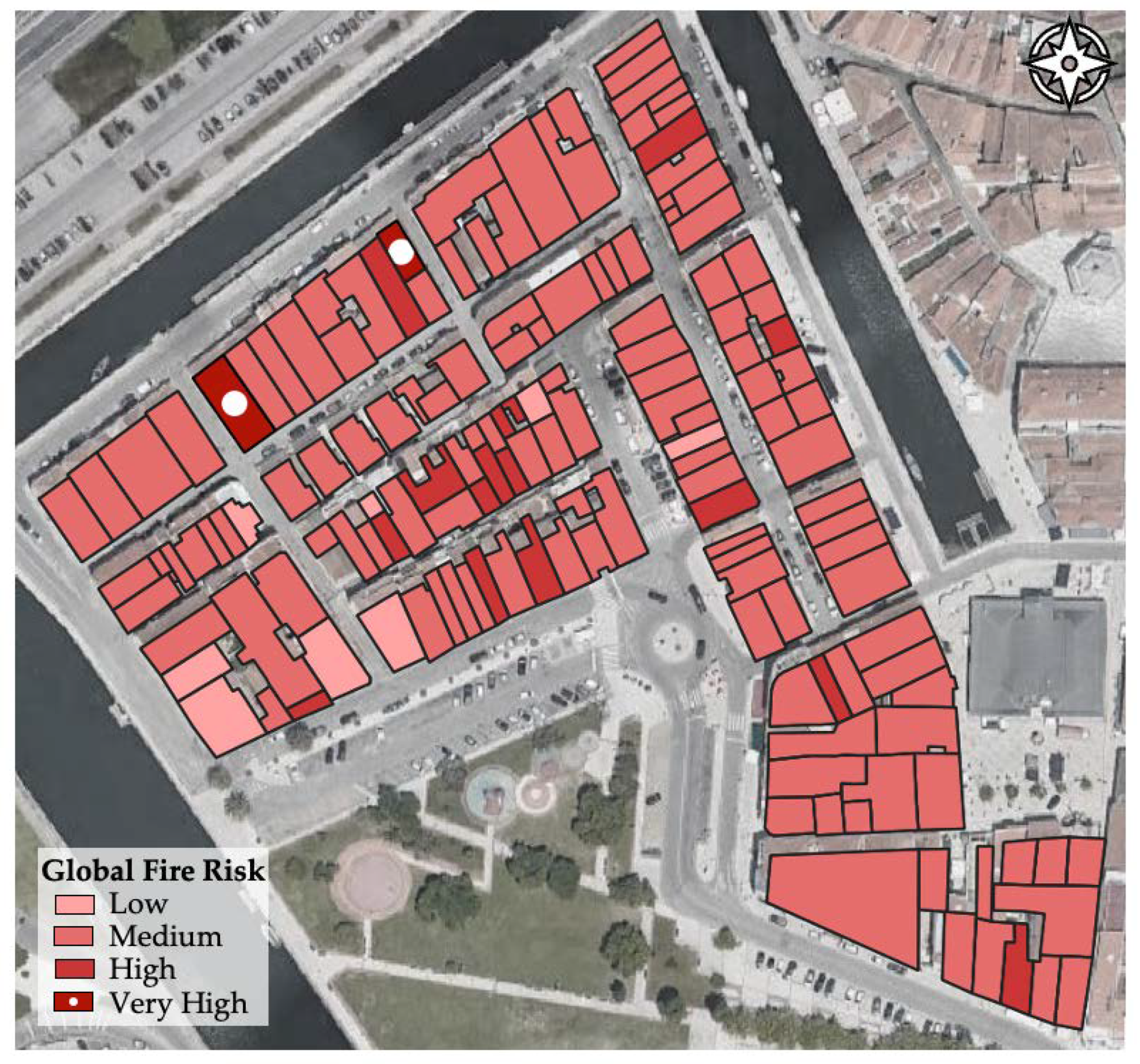
3. Fire Risk in the Historic City Centre of Aveiro
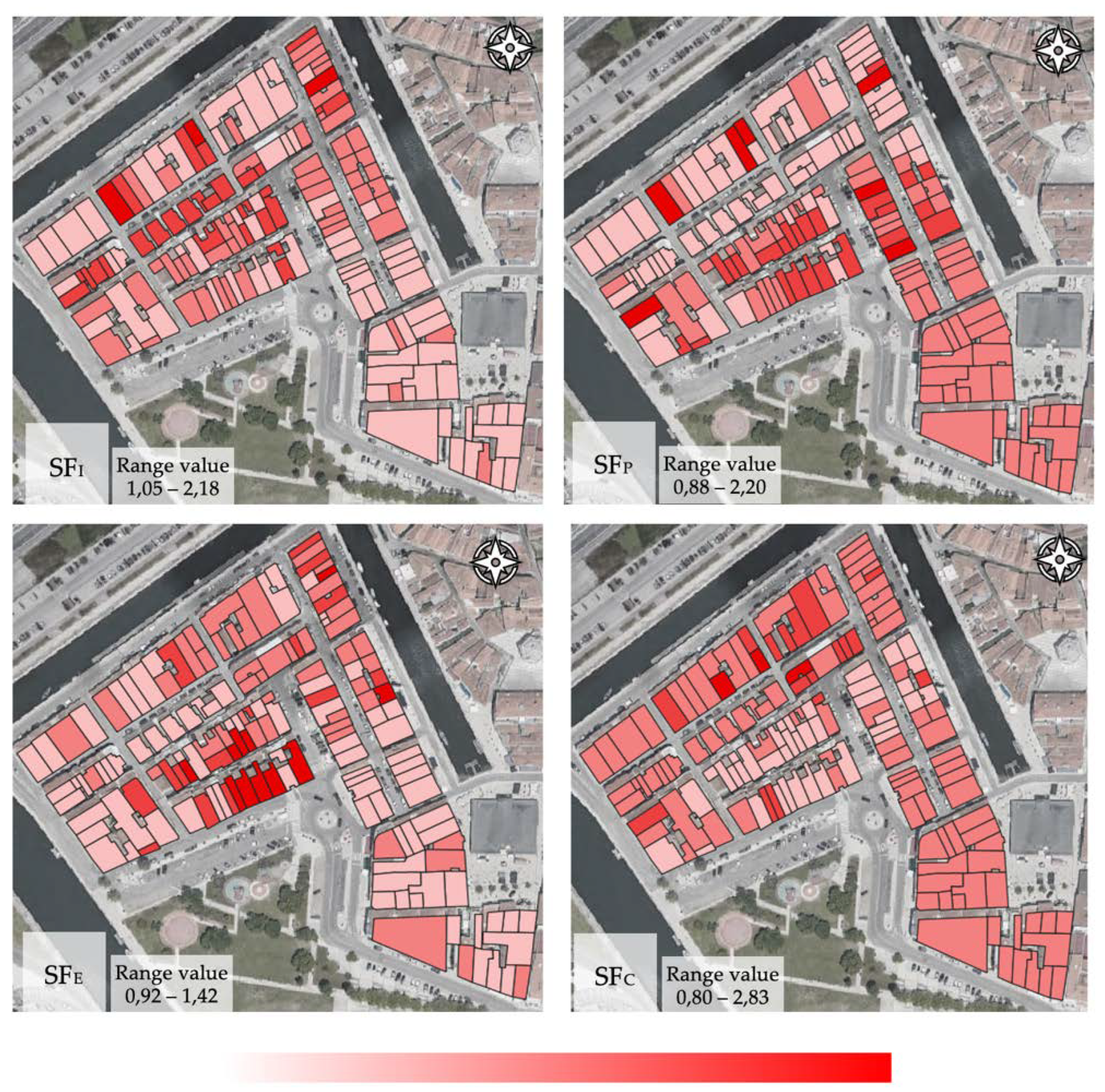
Fire Risk per Sub-Factor
4. Mitigation Strategies
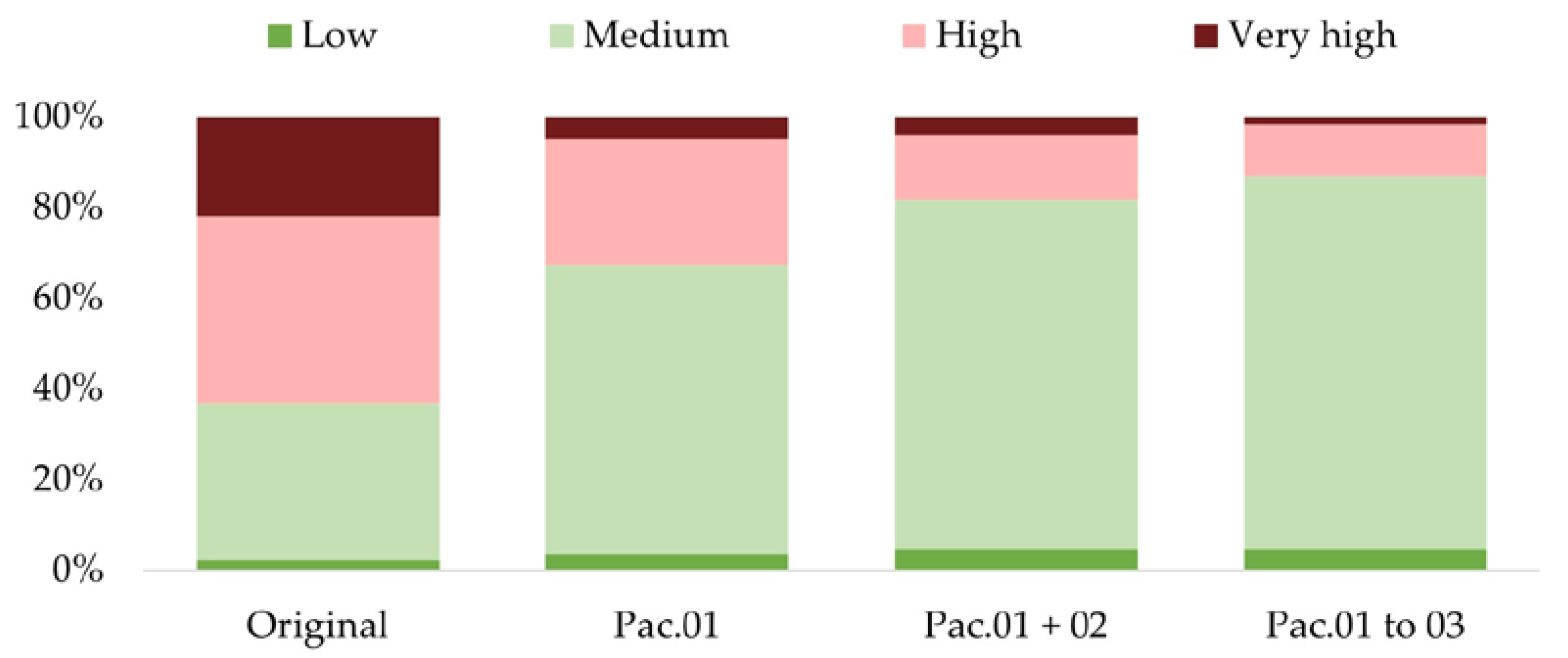
4.1. Public Mitigation Measures with Strong Impact
4.2. Individual Mitigation Measures with Strong Impact
4.3. Low Effort Strategies with Minor Impact
5. Conclusions
Author Contributions
Funding
Institutional Review Board Statement
Informed Consent Statement
Data Availability Statement
Acknowledgments
Conflicts of Interest
References
- Lidelöw, S.; Örn, T.; Luciani, A.; Rizzo, A. Energy-Efficiency Measures for Heritage Buildings: A Literature Review. Sustain. Cities Soc. 2019, 45, 231–242. [Google Scholar] [CrossRef]
- Arfa, F.H.; Zijlstra, H.; Lubelli, B.; Quist, W. Adaptive Reuse of Heritage Buildings: From a Literature Review to a Model of Practice. Hist. Environ. Policy Pract. 2022, 13, 148–170. [Google Scholar] [CrossRef]
- Machete, R.; Silva, J.R.; Bento, R.; Falcão, A.P.; Gonçalves, A.B.; Lobo de Carvalho, J.M.; Silva, D.V. Information Transfer between Two Heritage BIMs for Reconstruction Support and Facility Management: The Case Study of the Chalet of the Countess of Edla, Sintra, Portugal. J. Cult. Herit. 2021, 49, 94–105. [Google Scholar] [CrossRef]
- Zhang, F.; Shi, L.; Liu, S.; Shi, J.; Zhang, J. CFD-Based Framework for Fire Risk Assessment of Contiguous Wood-Frame Villages in the Western Hunan Region. J. Build. Eng. 2022, 54, 104607. [Google Scholar] [CrossRef]
- Torero, J.L. Fire Safety of Historical Buildings: Principles and Methodological Approach. Int. J. Archit. Herit. 2019, 13, 926–940. [Google Scholar] [CrossRef]
- Ferreira, T.M. Notre Dame Cathedral: Another Case in a Growing List of Heritage Landmarks Destroyed by Fire. Fire 2019, 2, 20. [Google Scholar] [CrossRef] [Green Version]
- Barbosa, F.H.D.S.; Araújo-Júnior, H.I. de Skeletal Pathologies in the Giant Ground Sloth Eremotherium Laurillardi (Xenarthra, Folivora): New Cases from the Late Pleistocene of Brazil. J. S. Am. Earth Sci. 2021, 110, 103377. [Google Scholar] [CrossRef]
- Motta, F.M.D.V.; Silva, R.A.R. da A Adoção de Tecnologias Digitais Na Reconstrução Do Patrimônio: Relato Da Experiência Do Museu Nacional, Brasil. Inf. Soc. Estud. 2020, 30, 1–16. [Google Scholar] [CrossRef]
- Decreto-Lei, n.o 224/2015 [Procede à Primeira Alteração Ao Decreto-Lei n.o 220/2008, de 16 de Dezembro, Que Estabelece o Regime Jurídico Da Urbanização e Edificação]. Diário Da República, 1.a Série, Portugal, 2015; pp. 8740–8774. (In Portuguese)
- ANEPC. Relatório de Atividades 2019; ANEPC, Oeiras, Portugal, 2020.
- ANEPC. Avaliação Nacional de Risco; ANEPC, Oeiras, Portugal, 2019; Volume 1a Atualiz.
- Granda, S.; Ferreira, T.M. Large-Scale Vulnerability and Fire Risk Assessment of the Historic Centre of Quito, Ecuador. Int. J. Archit. Herit. 2021, 15, 1043–1057. [Google Scholar] [CrossRef]
- Tozo Neto, J.; Ferreira, T.M. Assessing and Mitigating Vulnerability and Fire Risk in Historic Centres: A Cost-Benefit Analysis. J. Cult. Herit. 2020, 45, 279–290. [Google Scholar] [CrossRef]
- Mendes, P.; Correia, A.J.P.D.M. Análise Do Risco de Incêndio Em Zonas Urbanas Antigas–Centro Histórico de Coimbra, IPC-Instituto Politécnico de Coimbra: Coimbra, Portugal, 2015.
- Pais, P.; Santos, C. Avaliação de Risco de Incêndio Em Centros Históricos-o Caso de Castelo Branco. Agroforum Rev. Esc. Super. Agrária Castelo Branco 2015, 23, 39–50. [Google Scholar]
- Ferreira, T.M.; Vicente, R.; Raimundo Mendes da Silva, J.A.; Varum, H.; Costa, A.; Maio, R. Urban Fire Risk: Evaluation and Emergency Planning. J. Cult. Herit. 2016, 20, 739–745. [Google Scholar] [CrossRef] [Green Version]
- Decreto-Lei, n.o 220/2008 [Estabelece o Regime Jurídico Da Segurança Contra Incêndios Em Edifícios]. Diário Da República, 1.a Série. Portugal, 2008; pp. 7903–7922. (In Portuguese)
- Decreto-Lei, n.o 95/2019 [Estabelece o Regime Aplicável à Reabilitação de Edifícios Ou Frações Autónomas]. Diário Da República, 1.a Série, Portugal, 2019; pp. 35–45. (In Portuguese)
- Guerrero-Meseguer, L.; Veiga, P.; Sampaio, L.; Rubal, M. Resurgence of Zostera Marina in the Ria de Aveiro Lagoon, Portugal. Aquat. Bot. 2021, 169, 103338. [Google Scholar] [CrossRef]
- Camara Municipal de Aveiro. Operação de Reabilitação Urbana (ORU)-Programa Estratégico de Reabilitação Urbana (PERU); Camara Municipal de Aveiro: Aveiro, Portugal, 2019. [Google Scholar]
- Varum, H.; Costa, A.; Fonseca, J.; Furtado, A. Behaviour Characterization and Rehabilitation of Adobe Construction. Procedia. Eng. 2015, 114, 714–721. [Google Scholar] [CrossRef] [Green Version]
- Martins, T.; Fernández, J.; Varum, H. Influence of Moisture on the Mechanical Properties of Load-Bearing Adobe Masonry Walls. Int. J. Archit. Herit. 2019, 13, 841–854. [Google Scholar] [CrossRef]
- Silveira, D.; Varum, H.; Costa, A.; Neto, C. Survey of the Facade Walls of Existing Adobe Buildings. Int. J. Archit. Herit. 2016, 10, 867–886. [Google Scholar] [CrossRef] [Green Version]
- Gholitabar, S.; Alipour, H.; da Costa, C.M.M. An Empirical Investigation of Architectural Heritage Management Implications for Tourism: The Case of Portugal. Sustainability 2018, 10, 93. [Google Scholar] [CrossRef] [Green Version]
- Granda, S.; Ferreira, T.M. Assessing Vulnerability and Fire Risk in Old Urban Areas: Application to the Historical Centre of Guimarães. Fire Technol. 2019, 55, 105–127. [Google Scholar] [CrossRef]
- Ferreira, A.S.R.; Vicente, R.D.S.; Rodrigues, M.F. da S. Risco de Incêndio Em Centros Históricos: Índice de Risco; University of Aveiro: Aveiro, Portugal, 2010. [Google Scholar]
- Muculo, C. Avaliação de Risco de Incêndio Pelo Método ARICA a Edifícios no Porto; University of Porto: Oporto, Portugal, 2013. [Google Scholar]
- Wang, K.; Yuan, Y.; Chen, M.; Wang, D. A POIs Based Method for Determining Spatial Distribution of Urban Fire Risk. Process Saf. Environ. Prot. 2021, 154, 447–457. [Google Scholar] [CrossRef]
- Masoumi, Z.; Genderen, J.V.L.; Maleki, J. Fire Risk Assessment in Dense Urban Areas Using Information Fusion Techniques. ISPRS Int. J. Geoinf. 2019, 8, 579. [Google Scholar] [CrossRef] [Green Version]
- Hassanain, M.A.; Al-Harogi, M.; Ibrahim, A.M. Fire Safety Risk Assessment of Workplace Facilities: A Case Study. Front Built. Env. 2022, 8, 23. [Google Scholar] [CrossRef]
- Lee, J.H.; Chun, W.Y.; Choi, J.H. Weighting the Attributes of Human-Related Activities for Fire Safety Measures in Historic Villages. Sustainability 2021, 13, 3236. [Google Scholar] [CrossRef]


| Global Risk Factor (GRF) | Global Efficiency Factor (GEF) | ||
|---|---|---|---|
| Sub-Factors (SF) | |||
| SFI (Ignition) | SFP (Propagation) | SFE (Evacuation) | SFC (Combat) |
| Partial Factors (PF) | |||
| PFA1 (Building conservation) PFA2 (Conditions of electric installations) PFA3 (Conditions of gas installations) PFA4 (Fire load nature) | PFB1 (Distance between parallel openings) PFB2 (Safety teams in the building) PFB3 (Existence of fire alarm) PFB4 (Intern compartmentalisation) PFB5 (Fire loads) | PFC1 (Conditions of the evacuation routes) PFC2 (Building properties) PFC3 (Correction factor for evacuation) | PFD1 (Conditions of external firefighting equipment) PFD2 (Conditions of internal firefighting equipment) PFD3 (Preparation of safety teams in the building) |
| Value of GFR | Classification |
|---|---|
| GFR ≤ 0.9 | Low Risk |
| 0.9 > GFR ≥ 1.0 | Medium Risk |
| 1.0 > GFR ≥ 1.1 | High Risk |
| GFR > 1.1 | Very High Risk |
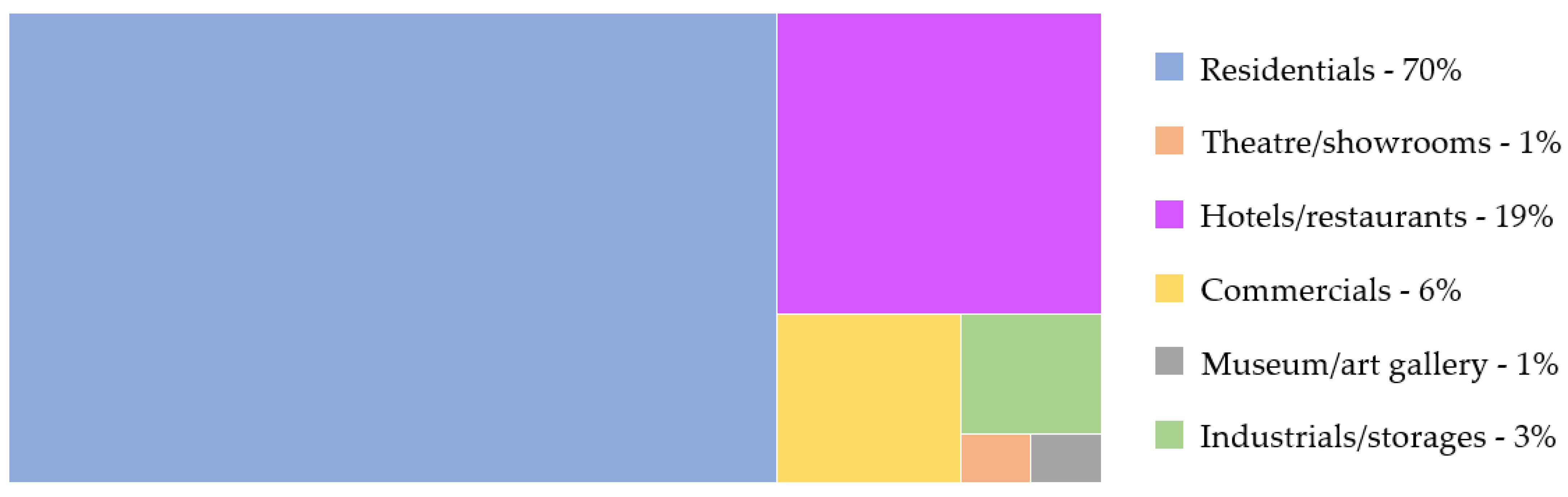
| Typology of Use | Global Fire Risk Categorisation | Total Σ (Use) | |||
|---|---|---|---|---|---|
| Low | Medium | High | Very High | ||
| Residential | 1.7% | 21.0% | 30.6% | 16.1% | 69.4% |
| Theatre/auditorium | 0.0% | 0.6% | 0.0% | 0.0% | 0.6% |
| Hotel/restaurant | 0.6% | 11.3% | 5.9% | 0.8% | 18.6% |
| Commercial | 0.0% | 1.3% | 4.7% | 0.7% | 6.7% |
| Museum/art gallery | 0.0% | 0.6% | 0.0% | 0.0% | 0.6% |
| Industrial/storage | 0.0% | 0.0% | 0.0% | 4.2% | 4.2% |
| Total Σ (Categories) | 2.3% | 34.8% | 41.2% | 21.8% | 100.0% |
| Typology of Use | Global Fire Risk Categorisation | |||
|---|---|---|---|---|
| Low | Medium | High | Very High | |
| Residential | 3.0% | 48.2% | 17.5% | 0.8% |
| Theatre/auditorium | 0.0% | 0.6% | 0.0% | 0.0% |
| Hotels/restaurants | 0.6% | 16.5% | 1.4% | 0.8% |
| Commercial | 0.0% | 2.6% | 3.5% | 0.8% |
| Museum/art gallery | 0.0% | 0.6% | 0.0% | 0.0% |
| Industrial/storage | 0.0% | 0.0% | 1.4% | 2.3% |
| Total Σ (Categories) | 3.6% | 63.8% | 28.0% | 4.7% |
| Typology of Use | Global Fire Risk Categorisation | |||
|---|---|---|---|---|
| Low | Medium | High | Very High | |
| Residential | 4.2% | 55.0% | 9.2% | 0.0% |
| Theatre/auditorium | 0.0% | 0.7% | 0.0% | 0.0% |
| Hotels/restaurants | 0.6% | 16.7% | 1.4% | 0.8% |
| Commercial | 0.0% | 4.0% | 2.2% | 0.8% |
| Museum/art gallery | 0.0% | 0.6% | 0.0% | 0.0% |
| Industrial/storage | 0.0% | 0.0% | 1.4% | 2.3% |
| Total Σ (Categories) | 4.8% | 77.1% | 14.2% | 3.9% |
| Typology of Use | Global Fire Risk Categorisation | |||
|---|---|---|---|---|
| Low | Medium | High | Very High | |
| Residential | 4.2% | 57.3% | 7.1% | 0.0% |
| Theatre/auditorium | 0.0% | 0.7% | 0.0% | 0.0% |
| Hotels/restaurants | 0.6% | 17.5% | 1.4% | 0.0% |
| Commercial | 0.0% | 5.4% | 1.5% | 0.0% |
| Museum/art gallery | 0.0% | 0.6% | 0.0% | 0.0% |
| Industrial/storage | 0.0% | 0.7% | 1.5% | 1.6% |
| Total Σ (Categories) | 4.9% | 82.2% | 11.4% | 1.6% |
Publisher’s Note: MDPI stays neutral with regard to jurisdictional claims in published maps and institutional affiliations. |
© 2022 by the authors. Licensee MDPI, Basel, Switzerland. This article is an open access article distributed under the terms and conditions of the Creative Commons Attribution (CC BY) license (https://creativecommons.org/licenses/by/4.0/).
Share and Cite
Silva, D.; Rodrigues, H.; Ferreira, T.M. Assessment and Mitigation of the Fire Vulnerability and Risk in the Historic City Centre of Aveiro, Portugal. Fire 2022, 5, 173. https://doi.org/10.3390/fire5050173
Silva D, Rodrigues H, Ferreira TM. Assessment and Mitigation of the Fire Vulnerability and Risk in the Historic City Centre of Aveiro, Portugal. Fire. 2022; 5(5):173. https://doi.org/10.3390/fire5050173
Chicago/Turabian StyleSilva, Dener, Hugo Rodrigues, and Tiago Miguel Ferreira. 2022. "Assessment and Mitigation of the Fire Vulnerability and Risk in the Historic City Centre of Aveiro, Portugal" Fire 5, no. 5: 173. https://doi.org/10.3390/fire5050173