
Evaluation of the Impact of Seasonal Agroclimatic Information Used for Early Warning and Farmer Communities’ Vulnerability Reduction in Southwestern Niger
 ,
,
Abstract
:1. Introduction
2. Material and Methods
2.1. Material
- An individual survey form, containing questions about identification and socio-economic description, types of agroclimatic services received, benefits gained, and actions taken to reduce the communities’ vulnerability. To facilitate the data collection, interview guidelines were designed for each type of interviewer.
- Sphinx Plus 2 software, used for the development of the questionnaire, the compilation of the answers, the processing and analysis of the survey data from the field, and the generation of outputs from the questionnaires.
- QGISv3.10.10, for the spatial mapping.
- Microsoft package (Excel, Word, etc.), for the graphical representation of some results.
2.2. Methods
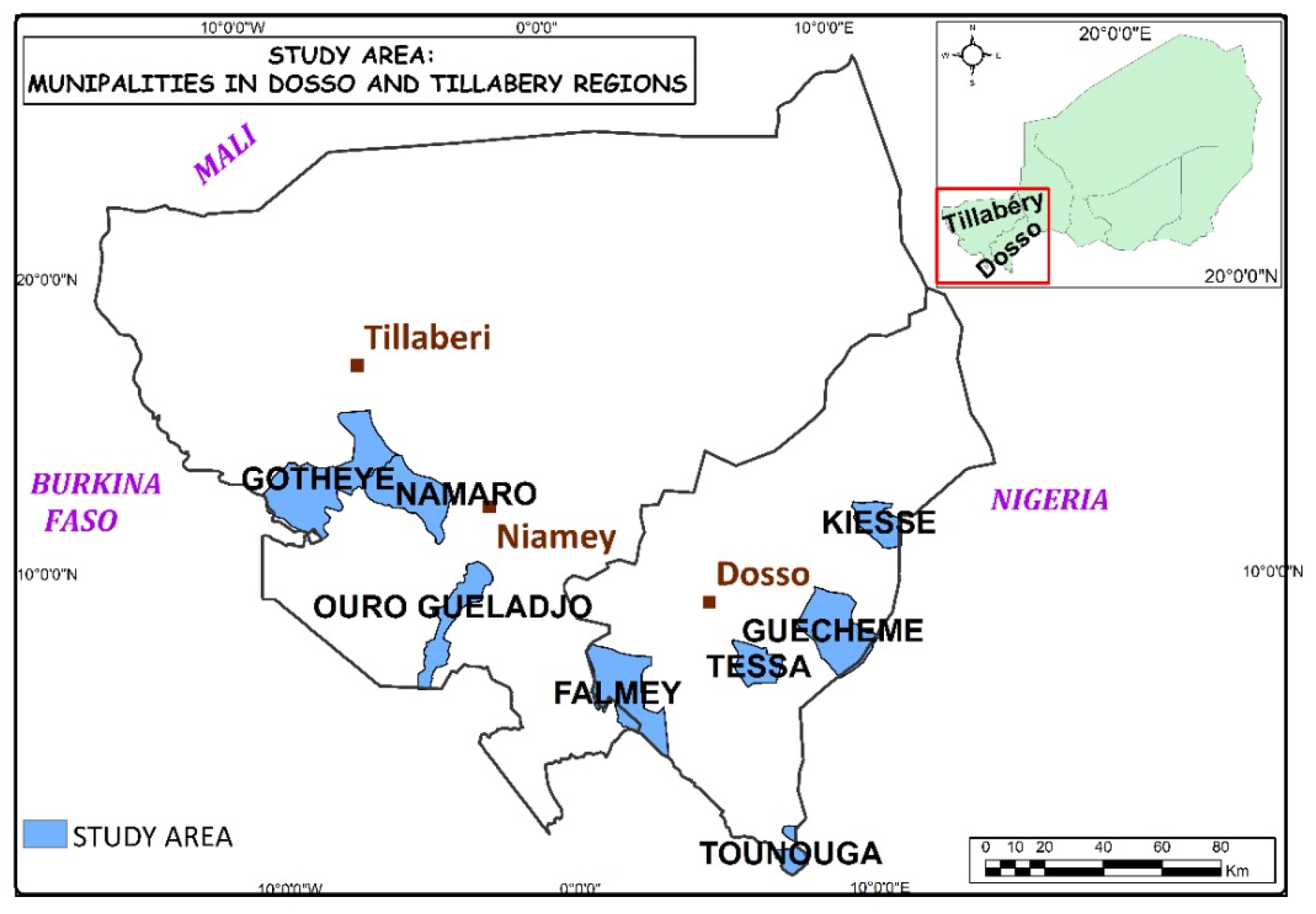
2.2.1. Study Area
2.2.2. Optimal Sample Size and Survey Method
3. Results
3.1. Socio-Economic Characteristics of the Populations
3.2. Climate Information Services
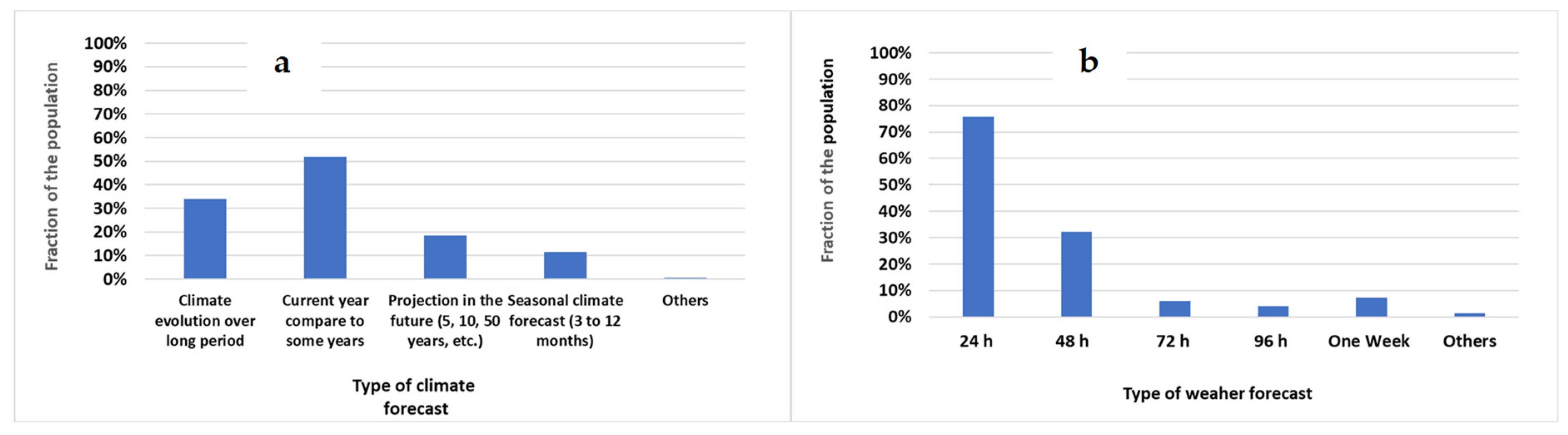
3.2.1. Types of Information
3.2.2. Dissemination of Climate Services
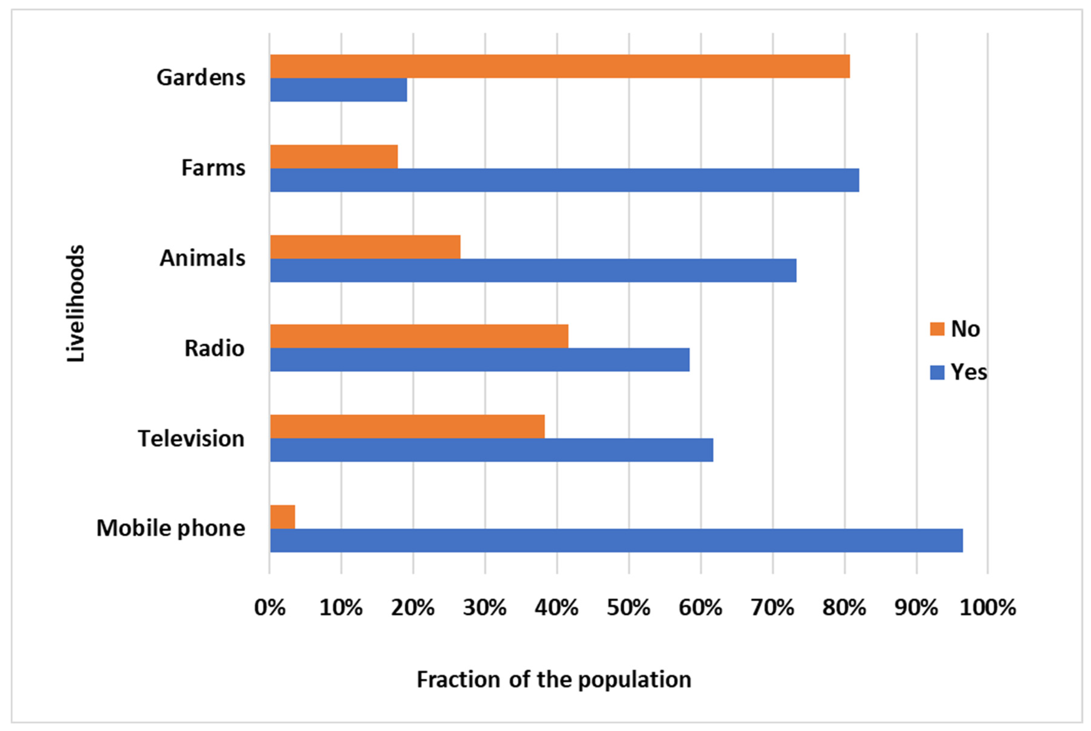
3.3. Benefits of Climate Information
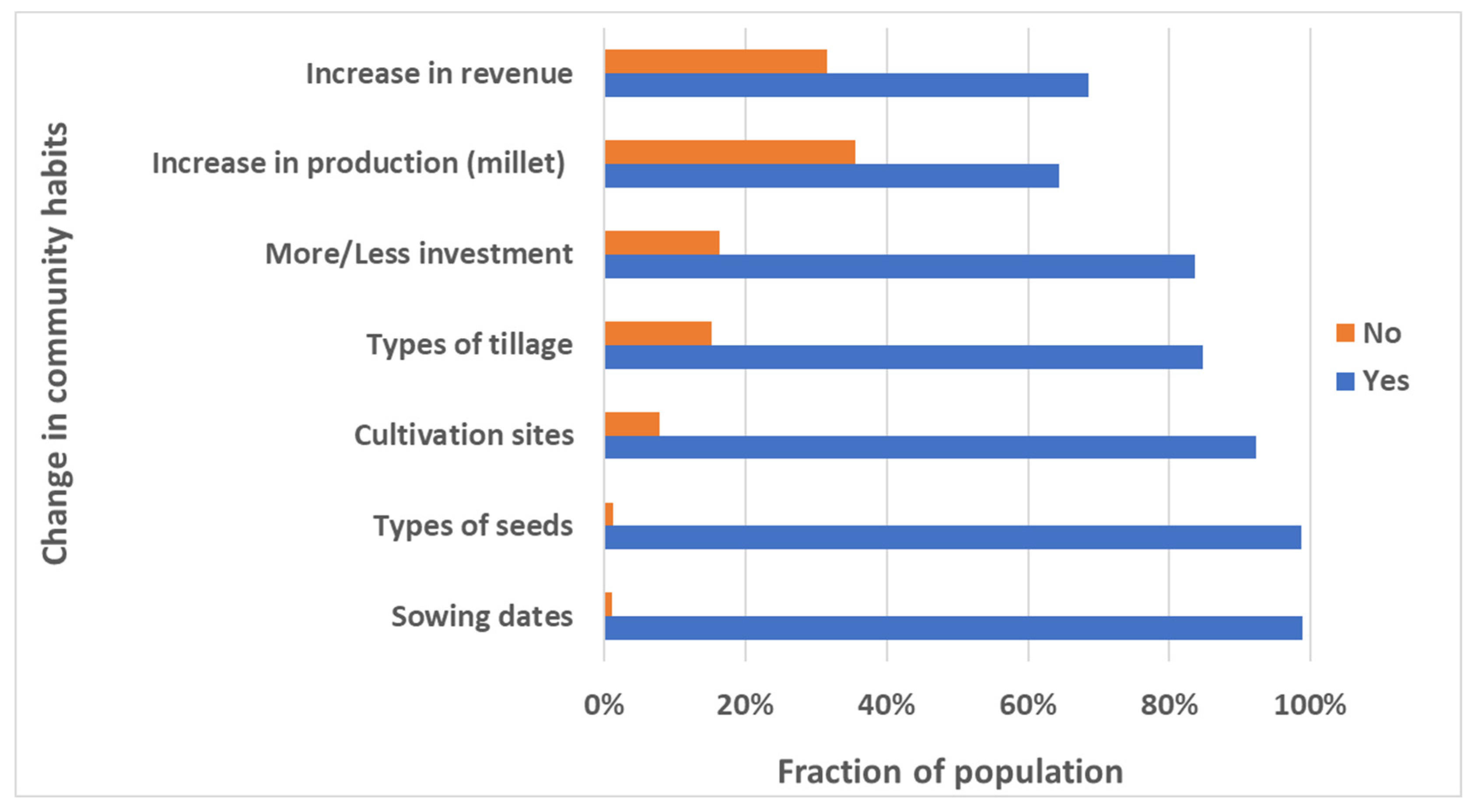
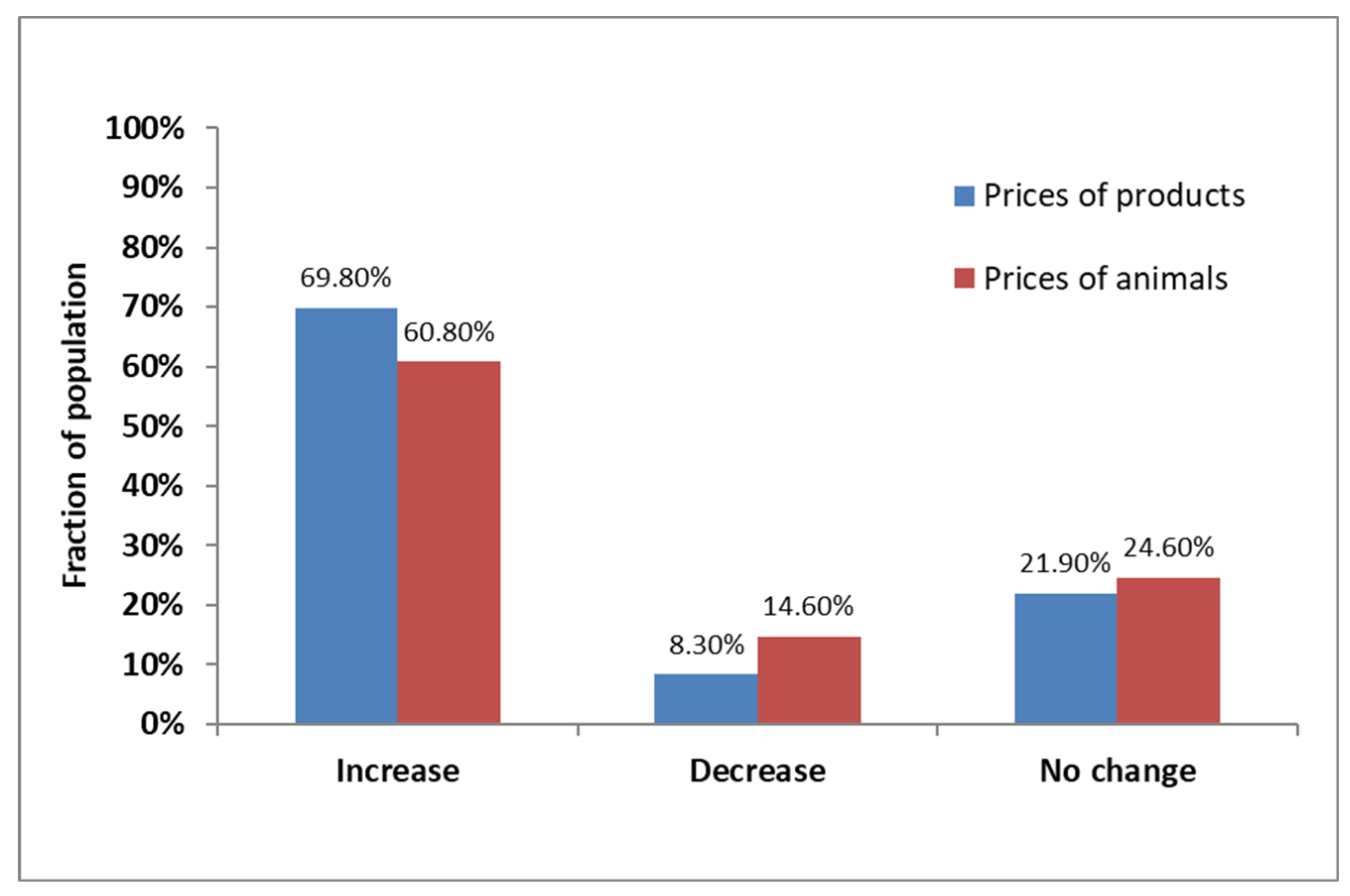
3.3.1. Agriculture and Livestock
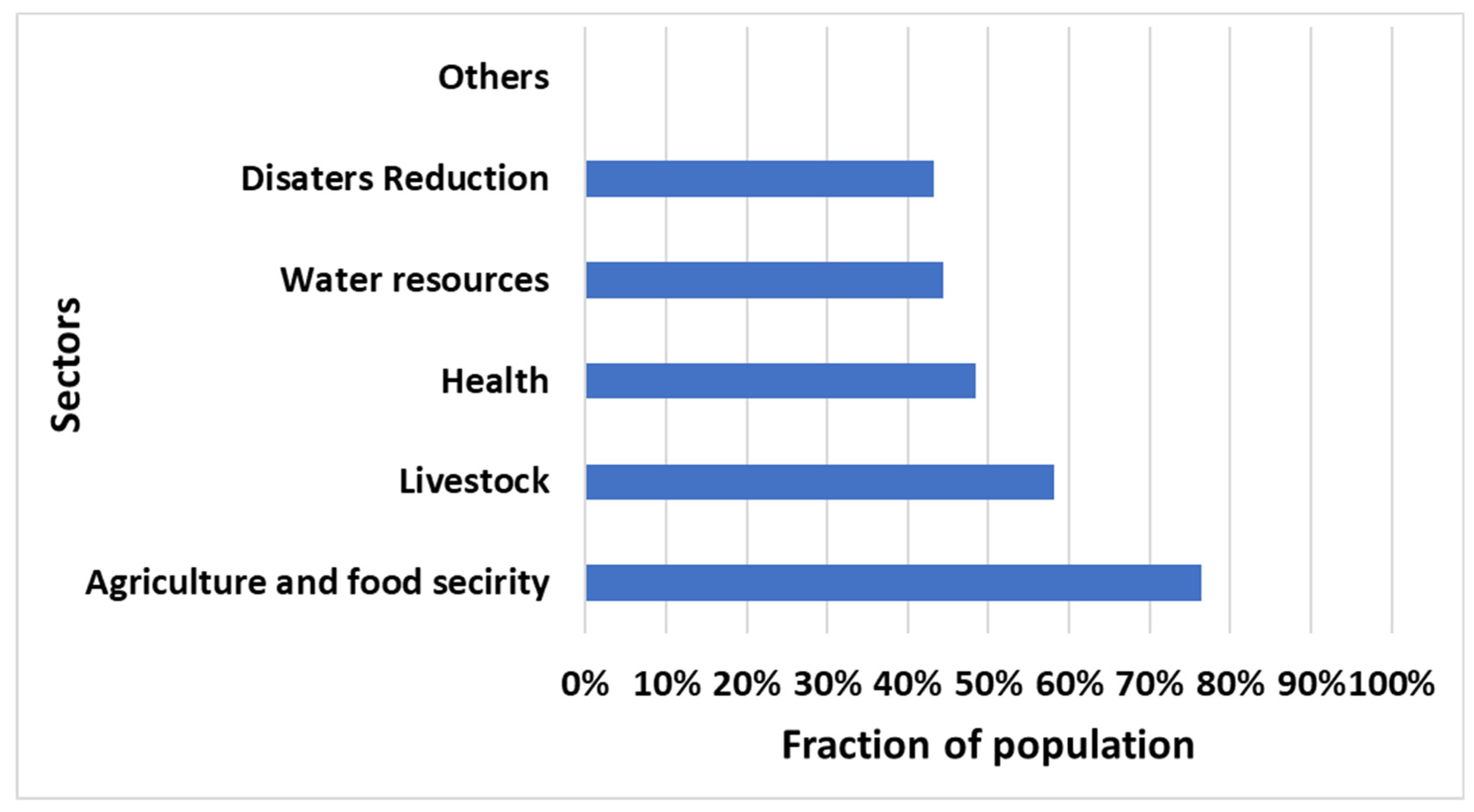
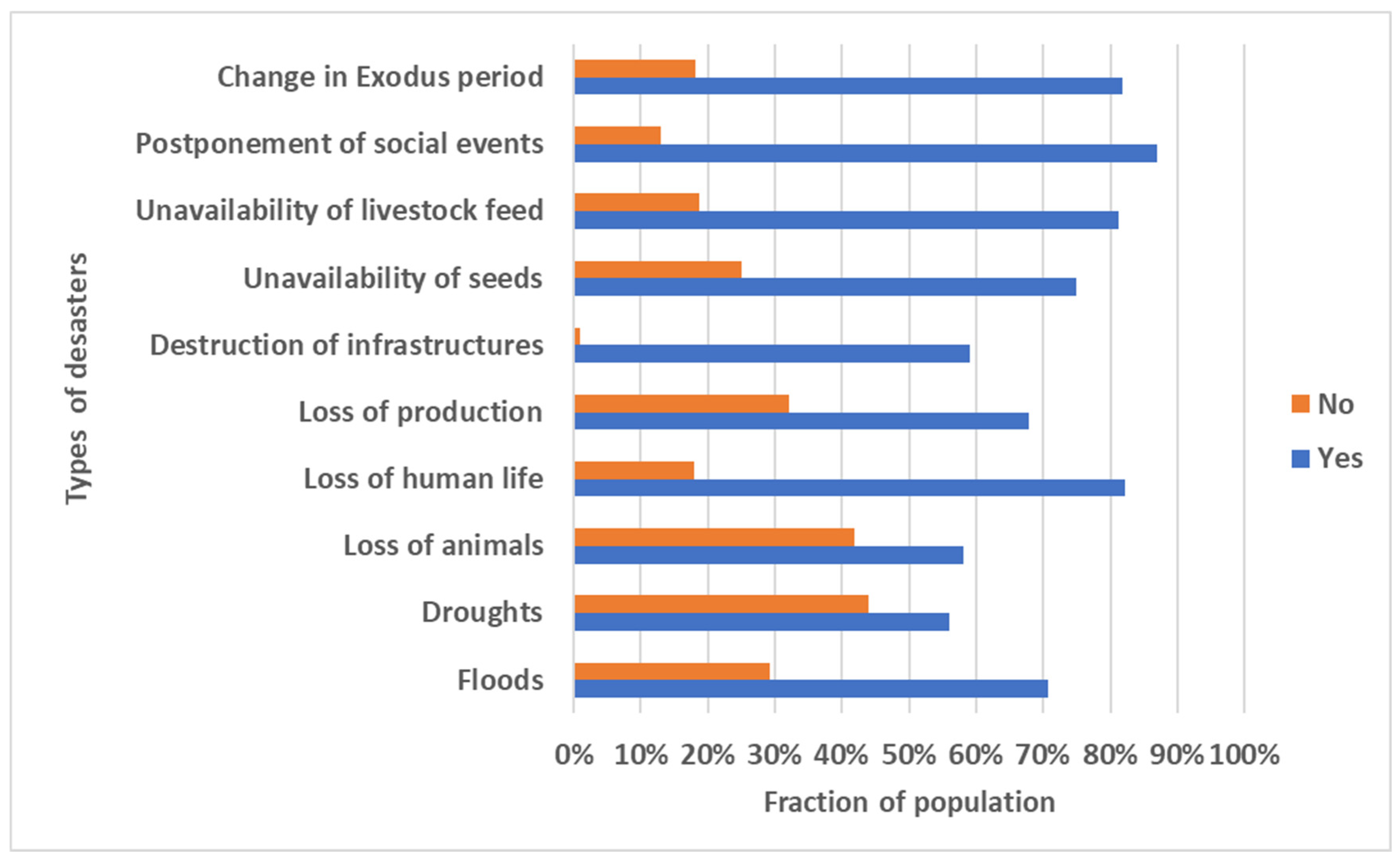
3.3.2. Risk Reduction
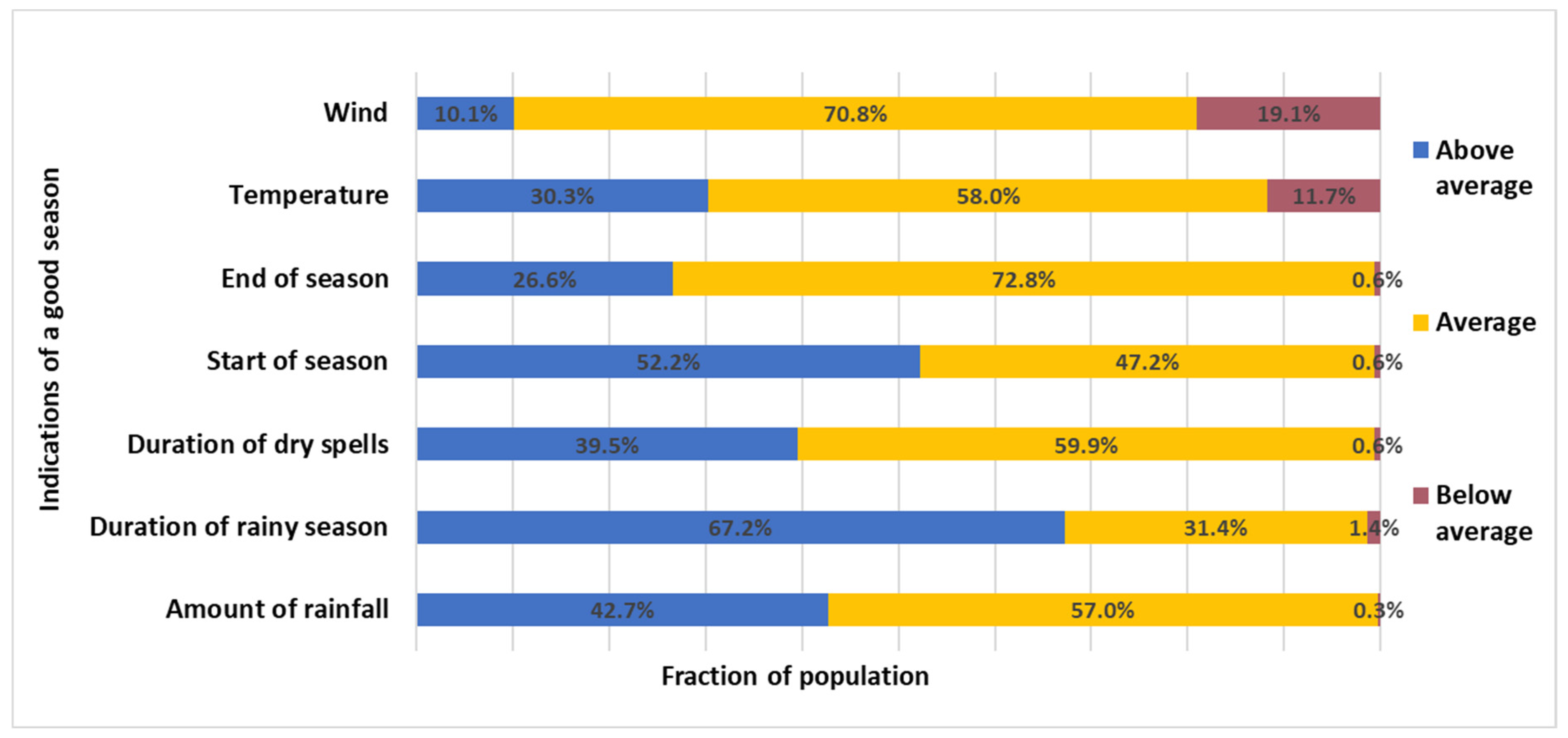
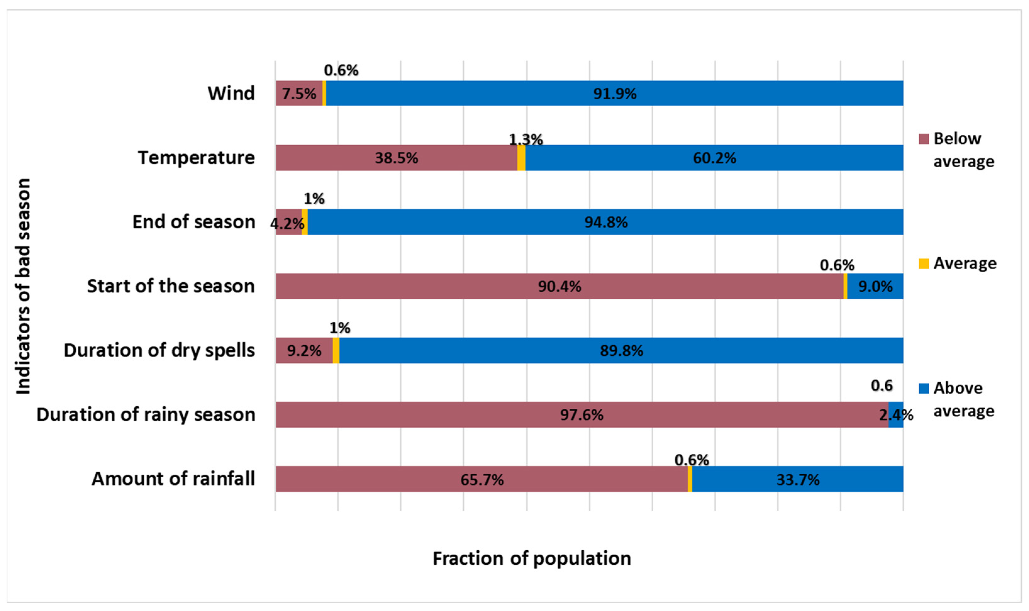
3.4. Perception of Seasonal Agroclimatic Characteristics and Coping Strategies
4. Discussion
5. Conclusions
Author Contributions
Funding
Institutional Review Board Statement
Informed Consent Statement
Acknowledgments
Conflicts of Interest
References
- Cane, M.A.; Eshel, G.; Buckland, R.W. Forecasting Zimbabwean maize yield using eastern equatorial Pacific Sea surface temperature. Nature 1994, 370, 204–205. [Google Scholar] [CrossRef]
- Tinni, H.S.; Alhassane, A.; Lona, I.; Bouzou, M.I. Analyse de l’évolution spatio-temporelle des dérivés pluviométriques caractérisant la saison agricole au Sahel—Central. Afr. Sci. 2021, 19, 102–121. [Google Scholar]
- Hansen, J.W.; Indeje, M. Linking dynamic seasonal climate forecasts with crop simulation for maize yield prediction in semi-arid Kenya. Agric. For. Meteorol. 2004, 125, 143–157. [Google Scholar] [CrossRef]
- Hammer, G.L.; Carberry, P.; Stone, R. Comparing the value of seasonal climate forecasting systems in managing cropping systems. In Applications of Seasonal Climate Forecasting in Agricultural and Natural Ecosystems—The Australian Experience; Hammer, G.L., Nicholls, N., Mitchell, C., Eds.; Kluwer Academic Publishers: Dordrecht, The Netherlands, 2000; pp. 183–195. [Google Scholar]
- Moorhead, A. Climate, Agriculture and Food Security: A Strategy for Change; Alliance of the CGIAR Centers: Washington, DC, USA, 2009. [Google Scholar]
- Roudier, P.; Sultan, B.; Quirion, P.; Baron, C.; Alhassane, A.; Traoré, S.B.; Muller, B. An ex-ante evaluation of the use of seasonal climate forecasts for millet growers in SW Niger. Int. J. Clim. 2011, 32, 759–771. [Google Scholar] [CrossRef] [Green Version]
- Roudier, P.; Alhassane, A.; Baron, C.; Louvet, S.; Sultan, B. Assessing the benefits of weather and seasonal forecasts to millet growers in Niger. Agric. For. Meteorol. 2016, 223, 168–180. [Google Scholar] [CrossRef]
- Patt, A.; Suarez, P.; Gwata, C. Effects of seasonal climate forecasts and participatory workshops among subsistence farmers in Zimbabwe. Proc. Natl. Acad. Sci. USA 2005, 102, 12623–12628. [Google Scholar] [CrossRef] [PubMed] [Green Version]
- Verdin, J.; Klaver, R. Grid-cell-based crop water accounting for the famine early warning system. Hydrol. Process. 2002, 16, 1617–1630. [Google Scholar] [CrossRef]
- Sultan, B. Les bénéfices des services climatiques pour l’agriculture au Niger. In Analyse environnementale et changement climatique dans trois communes d’intervention du Programme Alimentaire Mondial (PAM) au Niger; rapport global de l’analyse climatique, des services climatiques et des interventions du PAM dans les sites de Karkara, Sahiya, Darey et Toungfini (Niger) qui s’intitule; WFP: Rome, Italy, 2017. [Google Scholar]
- Cochran, W.G. Sampling Techniques, 3rd ed.; John Wiley & Sons: New York, NY, USA, 1977. [Google Scholar]
- Moussa, S.; Tougiani, A. Farmers’ strategies for adapting to climate change in Niger. ResearchGate 2020. Available online: https://www.researchgate.net/publication/347433113 (accessed on 9 January 2023).
- Broad, K.; Agrawala, S. The Ethiopia Food Crisis—Uses and Limits of Climate Forecasts. Science 2000, 289, 1693–1694. [Google Scholar] [CrossRef] [PubMed]
- Haile, M. Weather pattern, food security and humanitarian response in Sub Saharan Africa. Phil. Trans. R. Soc. B 2005, 360, 2169–2182. [Google Scholar] [CrossRef] [PubMed] [Green Version]
- Sultan, B.; Barbier, B.; Fortilus, J.; Mbaye, S.M.; Leclerc, G. Estimating the potential economic value of the seasonal forecasts in West Africa: A long-term ex-ante assessment in Senegal. Weather. Clim. Soc. 2010, 2, 69–87. [Google Scholar] [CrossRef]
- Pasini, A.; De Felice Proia, G.; Tubiello, F.N. Influence of Meteo-Climatic Variables and Fertilizer Use on Crop Yields in the Sahel: A Nonlinear Neural-Network Analysis. Climate 2022, 10, 193. [Google Scholar] [CrossRef]


| Estimated Population in 2020 | Estimated Population between 18 to 60 Years Old | Proportion of Population (18 to 60 Years)/Total Population (p) | Level of Confidence Z = 1.96 | Proportion q = 1 − p | Error e = 5% | Estimated Households |
|---|---|---|---|---|---|---|
| 640,004 | 254,302 | 0.40 | 1.96 | 0.60 | 0.05 | 368 |
| Speculation | Cereals | Vegetables | Tubers/Roots | Fruits | ||||||
|---|---|---|---|---|---|---|---|---|---|---|
| Millet | Sorghum | Corn | Rice | Others | cowpeas | Others | Cassava | Others | ||
| Proportion of population (%) | 85.3 | 31.2 | 6.8 | 15.5 | 0.5 | 82.3 | 7.9 | 12.5 | 4.9 | 6.8 |
| Means of Communication | Access (%) | Type (%) | |||
|---|---|---|---|---|---|
| Yes | No | National | Private | Community | |
| Radio | 98.4 | 1.6 | 51.1 | 17.9 | 60.1 |
| Television | 72.8 | 27.2 | 65.5 | 26.6 | 0.5 |
| Mobile phone | 96.5 | 3.5 | |||
| Internet | 51.8 | 48.2 | |||
| 1 | 2 | 3 | 4 | 5 | 6 | 7 |
|---|---|---|---|---|---|---|
| Rainfall Amounts | Start of the Season | End of the Season | Length of the Season | Length of Dry Spells | Temperatures | Winds |
|
|
|
|
|
|
|
| 1 | 2 | 3 | 4 | 5 | 6 | 7 |
|---|---|---|---|---|---|---|
| Rainfall Amounts | Starts of the Season | End of the Season | Length of the Season | Length of Dry Spells | Temperatures | Winds |
|
|
|
|
|
|
|
Disclaimer/Publisher’s Note: The statements, opinions and data contained in all publications are solely those of the individual author(s) and contributor(s) and not of MDPI and/or the editor(s). MDPI and/or the editor(s) disclaim responsibility for any injury to people or property resulting from any ideas, methods, instructions or products referred to in the content. |
© 2023 by the authors. Licensee MDPI, Basel, Switzerland. This article is an open access article distributed under the terms and conditions of the Creative Commons Attribution (CC BY) license (https://creativecommons.org/licenses/by/4.0/).
Share and Cite
Seydou, T.H.; Agali, A.; Aissatou, S.; Seydou, T.B.; Issaka, L.; Ibrahim, B.M. Evaluation of the Impact of Seasonal Agroclimatic Information Used for Early Warning and Farmer Communities’ Vulnerability Reduction in Southwestern Niger. Climate 2023, 11, 31. https://doi.org/10.3390/cli11020031
Seydou TH, Agali A, Aissatou S, Seydou TB, Issaka L, Ibrahim BM. Evaluation of the Impact of Seasonal Agroclimatic Information Used for Early Warning and Farmer Communities’ Vulnerability Reduction in Southwestern Niger. Climate. 2023; 11(2):31. https://doi.org/10.3390/cli11020031
Chicago/Turabian StyleSeydou, Tinni Halidou, Alhassane Agali, Sita Aissatou, Traore B. Seydou, Lona Issaka, and Bouzou Moussa Ibrahim. 2023. "Evaluation of the Impact of Seasonal Agroclimatic Information Used for Early Warning and Farmer Communities’ Vulnerability Reduction in Southwestern Niger" Climate 11, no. 2: 31. https://doi.org/10.3390/cli11020031