Review

Improving Early Warning of Drought in Australia

by
Stephen C. Lellyett
1,
Robert N. Truelove
2 and
Abul K. S. Huda
3,*
1
Independent Researcher, Sydney, NSW 2000, Australia
2
Independent Researcher, Cootamundra, NSW 2590, Australia
3
School of Science, Western Sydney University, Richmond, NSW 2753, Australia
*
Author to whom correspondence should be addressed.
Climate 2022, 10(7), 91; https://doi.org/10.3390/cli10070091
Submission received: 13 May 2022 / Revised: 3 June 2022 / Accepted: 9 June 2022 / Published: 21 June 2022
(This article belongs to the Special Issue Drought Early Warning)

Abstract

:
This invited review outlines a selection of recent technical and communication advances, in certain areas of climate and weather science that could improve the capability and utility of drought early warning systems in Australia. First, a selection of current operational outputs and their significance for drought early warning is reviewed, then a selection of advancements in the Research and Development (R&D) pipeline are considered, which have potential to help enable better decision-making by stakeholders subject to drought risk. The next generation of drought early warning systems should have a focus on index- and impact-based prediction models that go beyond basic weather and climate parameters, at seasonal through to multi-year timescales. Convergence and integration of emerging research, science and technology is called for across the fields of climate, agronomy, environment, economics and social science, to improve early warning information. The enablement of more predictively based drought policy, should facilitate more proactive responses by stakeholders throughout the agricultural value chain, and should make stakeholders more drought resilient.

1. Introduction

Policy initiatives to help farmers experiencing drought were introduced in the mid-20th century, but it was not until the late 1980s that the first statistical seasonal rainfall predictions emerged. Further development of seasonal climate predictions, and parallel investments in intensive agronomic systems research aimed at increasing the drought resilience of farming systems, led to the establishment of a new Australian National Drought Policy in 1992. This was a paradigm shift away from earlier crisis-driven subsidies, towards more proactive risk-management aimed at enabling self-reliance in managing climate variability (Laughlin & Clark [1]). It was recognised as world leading, with other nations following suit in later years (Stone [2]). Despite these advances, by 2014 widespread concern remained about the ineffectiveness of drought management practices still based largely on crisis management. At the time Australian drought policy centred upon direct payments to farmers linked to the declaration of “Drought Exceptional Circumstances”, based upon historic rainfall percentile thresholds for a given geographic region.
Building upon this broad contextual background, this paper examines selected recent advances, primarily in climate- and weather-related capabilities, that have helped enhance existing Drought Early Warning Systems. Furthermore, it recommends how those advances could be applied in developing the next generation of drought early warning systems for Australia. Improved understanding of climate, the expansion and quality improvement of data collection, and increases in computational power have opened the prospect of using sophisticated computer models to provide inputs to drought early warning systems, leading to better information about likely future weather. For this to enhance farmers’ decision-making there are two critical components; the predictive models forecasting future weather must be accurate, and outputs must be developed and recast in terms that stakeholders are able to understand, and are willing to use directly in their drought-related decision making. Because these advances include improved forecasts of future weather and climate, it follows that this should enable the adoption of more predictively based drought policy and more proactive responses to drought by stakeholders, thereby driving greater drought resilience and stakeholder self-reliance.

2. Some Challenges to Improving Drought Early Warning

The remit of drought early warning systems is wide. According to the United Nations International Strategy for Disaster Reduction [3], it spans the full gamut of coordination of policy and governance, risk identification and early warning, awareness and education, and mitigation and preparedness. In this paper we focus mainly on climate-related early warning information, its integration with other information, and its improving uptake and usage, as a critical component in enabling more holistic drought early warning systems.
A major challenge in transitioning towards self-reliance—which has been a long-term policy goal in Australia (Stone [2])—is the development of a drought early warning system that provides information of direct relevance to the specific decisions stakeholders must make, and does not require expert interpretation for implementation.
One barrier to this is the resolution of agreed definitions of the most relevant information. Previous drought definitions have fallen into a typology consisting of four broad categories; meteorological drought based on rainfall deficiencies; hydrological drought centring on the effect of dry spells upon surface and subsurface water; agricultural drought characterised by crop failure due mainly to available water deficiency in plants; and socioeconomic drought characterised by adverse socioeconomic outcomes (UNISDR [3], Wilhite and Glantz [4]). Within each of those categories the impacts on specific stakeholders differ, and it is now widely accepted that there is no universal drought indicator addressing all stakeholders, hence there is a need to develop specific indicators and measures for specific stakeholders. Despite these varied specific needs and impacts, at a fundamental level drought is driven, initially at least, by climate and weather inputs. Such inputs, and in particular the integration of forecasts with other non-meteorological variables, are essential to developing early warning information of direct relevance to specific stakeholder decisions.
In progressing towards more prediction-based drought policy and response, ongoing investment in retrospective analyses remains important, because this provides the basis for initiating, tuning, testing and evaluating predictive models, and it facilitates contextualisation of predictive model outputs. Thus, the development of retrospective analyses and predictions need to remain synchronised. The recent application of advanced interpolation techniques to historically sparse data has led to accurate and contiguous gridded datasets at 5 × 5 km, for key variables such as rainfall and soil moisture. The challenge remains to extend this to other key relevant drought parameters and then to further enhance resolution without degrading accuracy. Opportunities include denser observational networks, better use of high-resolution remote sensing, even more advanced interpolation, and more complex approaches such as dynamic model reanalysis.
With respect to spatial resolution, predictions have followed in sync, with retrospective analyses remaining a step ahead. Recent improvements in predictive model performance coupled with downscaling of outputs have also enabled prediction of basic meteorological parameters at a 5 × 5 km grid level. This is approaching a scale that is more directly useful for landholders, and it should help improve user confidence and drive better adoption, along with increasing the utility of information in decision-making.
Within the temporal domain the explicit definition of drought onset and cessation remains problematic. This is despite such information being highly sought and of great potential value to production decision-making and in the development of effective drought policy. Progress has recently been made in the development of better drought indices. Whilst useful, such indices often remain too broad in terms of drought-sensitivity and impact thresholds, which vary widely across sectors, businesses and communities. Adopting a single index may be convenient from a policy perspective, but more than one approach is required to best serve differentiated needs. This is relevant for all aspects of drought early warning, not just for onset and cessation.
The range of currently available operational predictands falls short of requirements. Variables and indices that can support new heuristics are required, more directly relevant to specific stakeholder decision-making. Considering the differences in drought sensitivity and impact thresholds, requirements include impact-based forecasts of available irrigated water, dam levels, land capacity for specific livestock, and growth and yield potential for specific crops, to enable forecasts of productivity under different land and water management strategies. From a policy perspective the need is for impact-based forecasts of outputs and indices, including agricultural total factor productivity, that can be interpreted into suitable contexts readily consumable by policy-makers.
The need for impact-based drought forecasts exists at all timescales of prediction. Fortunately, many of the individual elements for impact-based predictions can now be forecast, with the performance of the underlying predictions reaching levels capable of providing meaningful and reliable results. Realising this in operations will still require significant investment, including in sustained multi-disciplinary and multi-institutional collaboration.
The overall time intervals of predictions and the available sub-intervals are also critical for good decision-making. Until recently, seasonal forecasts have been available for an interval of three months ahead, with fortnightly intervals in the first month only. However, users in the agricultural sector need information for at least a full growing season ahead, with fortnightly intra-seasonal variations throughout the entire period desirable to inform key decisions. Ideally, predictions of at least broad-scale conditions would be extremely beneficial for several seasons ahead to enable optimised planning. Such capabilities are starting to emerge at the cutting edge and are worthy of investment for further development and transition to operations.
For very long-term planning, and to guide the development and implementation of climate change adaptation and mitigation strategies, high resolution climate change scenario modelling is also required. All of the generic issues described above must be addressed for long term projections. Critically, to facilitate responsible decision-making with respect to longer term investments, the full range of potential outcomes and associated uncertainty of projections must be made explicit and conveyed to users in formats they can readily comprehend.
Improved communication of forecasts, using graphics to display information in more enlightening ways, for example, and drought indices that integrate information from various data sources, hold promise for supporting improved adoption and decision-making. This especially applies to the framing and communication of probabilistic forecast information. To drive uptake and ease of use, the full gamut of available drought early warning information should be consolidated into one-stop-shops relevant to particular industries and subsectors.
Despite the abovementioned needs, drought policy has largely been informed retrospectively. Drought early warning systems that are more prediction-based will support more proactive policies that facilitate improved self-reliance and resilience throughout agricultural value chains. This direction of travel calls for improvements in the accuracy, relevance and contextualisation of predictions. In Australia, recent developments in science, technology and services capabilities have provided a solid base from which to address this. In some instances, explicit work has commenced.

3. Selected Advancements in Climate Information and Forecasting

In recent years, collection of comprehensive environmental and on-farm data has become more the cost-effective, while capabilities in historic analysis, climate forecasting and agronomic modelling have been enhanced. Possibilities have opened up for more integrated approaches to drought early warning systems and drought policy. This includes the potential for more integrated drought early warning with application across agricultural value chains. Below, we highlight a non-exhaustive subset of recent operational service advancements of significance.

3.1. Recent Advancements in Retrospective Analyses

3.1.1. High-Resolution Gridded Analyses and Their Extension to Other Variables

Until the 1990s, climate data from the Australian Bureau of Meteorology (BOM) was point source data only. Based on monthly rainfall data, the percentage land area in Australia with at least one station per 25 × 25 km grid box had fluctuated around 30% since about 1930 (Evans et al. [5])—the network was sparse. The data is sparser still for more frequent measurement periods, and yet sparser again for variables other than rainfall. Consequently, the uncertainty associated with using data from the nearest station varies from very representative to questionable at best. An accurate assessment of applicability of station data for a given site requires considerable professional climatological expertise. Gridded analyses at 25 × 25 km for major meteorological variables became freely available as online maps from BOM in the 1990s (Jones and Weymouth [6]). In 2009 the “Australian Water Availability Partnership” (AWAP) between BOM and the Commonwealth Science and Industrial Research Organisation (CSIRO), improved resolution for rainfall, temperature and vapour pressure to 5 × 5 km (Jones et al. [7]).
There are various ways to better increase grid resolution. The Australian surface rainfall network is sufficiently dense spatially, so that apart from filling in very large data voids, there are diminishing returns on investment in increased grid resolution (with the same or better accuracy and bias) through installing new stations. Greater and more immediate returns are available from investment in more advanced data interpolation techniques. Evans et al. [5] produced the first element of a new Australian Gridded Climate Dataset (AGCD) with the development of a national monthly gridded rainfall analyses at 1 × 1 km. The new dataset has significantly increased accuracy and reduced bias through the application of more advanced statistical interpolation techniques. It was estimated that to achieve equivalent resolution and accuracy from additional new stations alone would have required in the order of 2600 new stations nationally, each producing frequent automated observations, built and installed to high standards with long-term tenure.
The potential for third-party rainfall data to improve the accuracy of gridded rainfall analyses is very heavily dependent upon data and instrument quality and location. Inclusion of poor-quality information may degrade accuracy. Inclusion of additional data in already densely covered areas may have negligible impact. Conversely, high quality third-party data in data-sparse locations would be beneficial.
Baseline historical hydrological data including river flow measurements and dam inflows have also been improved. In 2008, the BOM–CSIRO alliance spawned an historically based landscape water balance model for Australia, AWRA-L (Australian Water Resources Assessment–Landscape model). In 2015 BOM freely released operational 5 × 5 km gridded nationwide AWRA-L outputs (Frost et al. [8]). Parameters of direct relevance to drought include historic daily 10 cm and 1 m soil moisture, evapotranspiration, runoff, and deep drainage, analysed back to 1900.
Whilst improvement of soil moisture information through strategic enhancement of the surface network at particular locations would be beneficial for satellite calibration and ground-truthing in large data voids, it would be prohibitively expensive simply to increase the overall density of surface soil moisture measurements to achieve a reliably accurate 5 × 5 km daily grid of soil moisture.
Streamflow and dam inflow estimates, relevant to the analysis of hydrological drought, have drawn on AWAP gridded rainfall analyses with investments to enhance baseline hydrological networks. These networks are operated by a large number of separate third-parties, whose data was brought together under an act of Parliament introduced in 2007, that compelled sharing to enable the development of significantly enhanced historic hydrological data.
Generally, the importance of using and integrating third-party data increases exponentially for perspectives further downstream from basic meteorological inputs. This is often due to an increasing number of different inputs, which are collectively only available by drawing upon multiple third-party sources.
Improvements to the basic meteorological inputs are fundamental to developing better systems for monitoring more complex environmental variables. AWRA-L is a case in point. The ground-based soil moisture network in Australia was distributed across numerous institutions and owners; a collaborative approach to data ownership and intellectual property issues was required. Even so, the combined network was insufficiently dense to support an accurate 5 × 5 km grid of national daily soil moisture estimates. Remotely sensed data from satellites were necessary to fill gaps in data-void areas, but that too was inadequate. What was needed was an overall water-balance model with the capability to ingest the raw soil moisture data from all sources and output soil moisture estimates interpolated onto a high-resolution grid. AWRA-L required other essential inputs too, including the abovementioned 5 × 5 km daily rainfall grid from the AWAP project.
Retrospective analyses have been central to climate change attribution studies, which compare climate model hindcasts with and without anthropogenic forcing, to simulate the observational record. For instance, Lewis and Karoly [9] utilised AWAP gridded data to show that at a continental scale the record high mean summer temperatures in 2013 were significantly more likely in anthropogenically forced Global Climate Model (GCM) runs, than under runs not anthropogenically forced. A critically important factor in enabling attribution studies—and also in calibrating and gauging the sensitivity of GCMs—is the use of historic gridded climate records. This is because robust assessment of GCM performance requires comparing the outputs of hindcasts with past observations to see how well GCMs reproduce the climate record and its associated climate variability.

3.1.2. Better Definitions of Drought Including the Use of Both Meteorological and Non-Meteorological Variables

The drought research community has for many decades sought to encapsulate definitions of drought by using drought indices. These typically comprise statistical representations of one or more variables to track drought status, as a basis for policy decision-making, and to help drive more effective actions by stakeholders in mitigating or adapting to drought impacts.
A significant challenge in the design of indices is that the impacts of drought vary enormously depending upon location, season, activity, socio-economic context and many other factors. That is to say, there is no single definition of drought that can accommodate all circumstances and impacts. Nevertheless, four previously mentioned high-level typologies of droughts (Meteorological, Agricultural, Hydrological and Socio-economic) can help (UNISDR [3], Wilhite and Glantz [4]). Meteorological drought is based largely on rainfall deficiencies over various durations, with many indices being univariate. Agricultural and Hydrological drought are physical manifestations of Meteorological drought, and usually follow Meteorological drought with successively longer timeframes. Agricultural drought centres on available water deficiency in plants, and actual versus potential evapotranspiration—such indices often include an array of input variables such as soil moisture, runoff, rainfall, evaporation and air temperature in their calculation. Hydrological drought involves reduced stream flows, ground water recharge and water storage; typical indices use many of the aforementioned inputs, and incorporate yet more variables such as hydrological relationships between flow and river height, dam inflow and release, deep water drainage, and so on. Socioeconomic drought manifests from imbalances caused by drought in supply and demand of economic goods, and may incorporate aspects of the other typologies. For example, the demand and supply of hydroelectric power has aspects of hydrological drought, but is also influenced by non-physical variables such as population growth.
A full discussion and assessment of available drought indices is beyond the scope of this paper, and readers interested in a detailed analysis and comparison of individual widely used indices, their trade-offs in applicability, performance, complexity of calculation, and ease of understanding, are referred to the World Meteorological Organisation–Global Water Partnership Handbook of Drought Indicators and Indices [10]. Points salient to our discussion are as follows: Firstly, the utility of drought early warning systems increases from the generic to successively more specific representations of drought and its consequences. Currently, drought science is moving towards more specificity. In this regard, moving through the typologies we see that the required number of meteorological and hydrological variables has increased, reinforcing the previously highlighted need for more and better retrospective datasets and analyses to support index design, historic calibration, and calculation. This is further reinforced for many indices that require input data without temporal gaps or missing data, which can be provided through gridded analysis.
Secondly, in general, the complexity and breadth of expertise required increases through Meteorological to Agricultural, Hydrological and Socioeconomic drought indices. Thus, the need for transdisciplinary collaboration should be emphasised. Thirdly, indices from any of the typologies are often designed for specific purposes—for example, to detect likely drought onset, or to gauge drought severity, or to identify some other specific manifestation of drought.
With regard to agriculture, a recent development in Australia has been the operational introduction of the “Combined Drought Index” in 2019 (Clark et al. [11]). This index defines various phases of drought at administrative parish level (typically 40–65 km2), to guide drought policy. It uses threshold-based categorisations of a Rainfall Index and Drought Direction Index based on gridded rainfall, a Soil Water Index based on soil water estimates from a simulation model, and a Plant Growth Index based on crop stress and pasture growth estimates from a simulation model. Important to the current discussion, to optimise the reliability of results the input data are generally gridded in the resolution range of 5 × 5 km to 250 × 250 m. Secondly, the range of variable inputs spans rainfall, maximum and minimum temperature, fraction of photosynthetically absorbed radiation, actual and potential evaporation, leaf area index, normalised vegetation index, soil type, and various land cover measures, all sourced from a diverse range of third-party providers.
Simulation modeling of agricultural production systems has been a major activity within international agricultural research, and provides a potentially rich source of information from which agricultural drought indices and impact-based forecasts can be developed. In Australia this research has played a pivotal role in understanding Genotype x Environment x Management interactions. Modelling of historic events can help identify likely threats to production systems, and to assess potential system fragility. This information can be used to inform management decisions with the aim of improving resilience to drought-related shocks. This is vitally important for managing food security.
Notably, however, most indices have in practice been applied only with current or antecedent data, and so tend to be retrospectively based. Of the few indices applied with predictive inputs, very few indeed have dealt effectively with probabilistic forecast data and their associated uncertainties—yet this is what modern seasonal forecasts and long-term climate projections aim to provide. Thus, future investment in research is called for to develop indices and impact-based forecasts for use in drought early warning systems. Moreover, to improve self-reliance and resilience in agricultural production, indices and impact indicators based on probabilistic inputs need to be integrated with the economics of production. In Section 4.4 we suggest a framework within which this could be developed.

3.2. Recent Advancements in Predictive Outputs and Projections

3.2.1. Seasonal to Inter-Annual Forecast Improvements

-
higher spatial resolution;
-
more granular forecast intervals;
-
extension of lead-times.
In 2007, for its national seasonal climate forecasting services, BOM commenced transitioning from a statistically based predictive model to the use of a dynamic globally coupled ocean-atmosphere model, known as Predictive Ocean Atmospheric Model for Australia (POAMA), (Wang et al. [12]). At 250 × 250 km the spatial resolution of POAMA was similar to the outgoing statistical system. However, the underlying non-stationary nature of climate timeseries had been increasingly undermining the accuracy of statistical predictions, due to the influence of anthropogenic climate change. Not only do dynamic models overcome this issue by modelling the major physical processes taking place in the atmosphere and oceans, they also differ from statistical models by generating other potential predictands. Additionally, they allow selection of differing forecast time intervals, without requiring model re-specification.
In all models the quality of inputs constrains the quality of outputs. Initial conditions defined by a grid of input variables, such as temperature, wind, and rainfall, are perturbed several times over to build an “ensemble” of similar but slightly different members. By running predictions forward in time for each member and then comparing the outputs, one can develop a probabilistic distribution of possible forecast outcomes, if the ensemble is large enough. The aforementioned development of gridded retrospective analyses has provided more accurate representations of current and historical conditions, which are critical for model calibration, initialisation and perturbation. Likewise, and even more important for predictive model performance, dramatic improvements were achieved in the quantity, quality and global coverage of remotely sensed upper-air data, plus ocean surface and sub-surface observations, especially over the Pacific and Indian Oceans. By 2013 POAMA was using a 33-member ensemble to produce operational forecasts to a lead time of three months (Hudson et al. [13]). The number of grid points globally was very large—atmospheric grid spacing of 250 km and 17 vertical levels with three layers of soil variables, and an ocean grid of 2 degrees longitudinally and 0.2–1.5 degrees latitudinally with 25 vertical levels. The number of calculations was exponentially higher with multiple, often non-linear equations, to be solved at each individual point; performing these calculations 33 times for each ensemble member, and then repeating everything at a timestep of under an hour. Hence the computational workload was very large. It is serendipitous that by 2013, not only had model physics improved significantly, but also that the very high computational intensity required was rendered feasible through advances in super-computing and availability of resources.
In 2018, a major step forward was the operationalisation of the ACCESS-S1 (Australian Climate Community Earth System Simulator-Seasonal prediction system version 1) global climate model (Hudson et al. [13]) and accompanying service upgrades, The underlying model is an adaptation of the GloSea5-GC2 global coupled model seasonal forecast system from United Kingdom’s Unified Model suite, widely recognised as one of the leading dynamic model suites in the world. In the ACCESS-S1 adaptation, differences from the UK version included a new method of ensemble construction and model initialisation. This supported the generation of the first multi-week forecasts (for example, predictions for a forecast period of weeks one and two combined, or weeks three and four combined) for Australia, using 99 member ensembles, and a forecast lead time extended to six months. Resolution was dramatically improved from 250 × 250 km through 17 vertical levels, to approximately 60 × 60 km through 85 vertical levels for the atmosphere; from 3 to 4 soil levels; and, from 2 × 0.2–1.5 degrees through 25 vertical levels to 0.25 × 0.25 degrees through 75 vertical levels for the oceans. Significant improvements in model physics were applied, including the handling of soil moisture and surface hydrology, ocean sub-surface processes connected to ENSO and inclusion of realistic Greenhouse Gas (GHG) forcing based on observations up to 2005 and the IPCC’s RCP 4.5 scenario thereafter (Hudson et al. [13]).
At ~60 km resolution, regional patterns associated with drought can be much better represented. Figure 1 shows a comparison of the typical extent of variations captured between historical AWAP analyses as mentioned previously, and ACCESS-S1 and POAMA. Better discerning features are especially evident over areas subject to significant orographic variability, including across the eastern Australian states associated with the Great Dividing mountain range, and the recognition of useful variations across the island state of Tasmania, which were previously unresolved by POAMA.
Improved resolution does not define, nor necessarily correlate with, model performance or accuracy. Crucial in a drought early warning context is the ability of seasonal climate models to forecast accurately variations in the major climate drivers of Australian rainfall, including ENSO (El Niño Southern Oscillation), IOD (Indian Ocean Dipole), SAM (Southern Annular Mode) and MJO (Madden–Julian Oscillation). These coupled ocean–atmosphere phenomena account for the bulk of seasonal to interannual variability in Australian rainfall, especially over the eastern states.
On climate drivers, ACCESS-S1 was found generally to have superior skill. The reader is referred to Hudson et al. [13] for a detailed discussion regarding the respective performance of POAMA and ACCESS-S1. We briefly summarise the key findings here; for ENSO, during its seasonal decline in predictability in the austral autumn (March-April-May), ACCESS-S1 outperforms POAMA. The same is true to a lesser degree in winter (June-July-August), whilst performance is similar for spring and summer. The IOD is particularly important for winter and spring rainfall over southern parts of Australia. During these periods there is significant overlap between the forecast skill of individual ensemble members within POAMA and ACCESS-S1, but the ACCESS-S1 ensemble mean shows generally superior forecast skill compared with the POAMA ensemble mean. SAM is important for multi-week climate variability and extremes over Australia. ACCESS-S1 showed superior correlation skill for observations, over a longer forecast duration, with forecasts outperforming climatology at 21 days lead-time versus 17 for POAMA, and less error spread than POAMA. The MJO dominates intra-seasonal variability in the tropics, for its prediction index ACCESS-S1 has a four-to-five day improvement in skill and a reduction in root-mean-square-error compared with POAMA; however, results are similar for the global scale propagation of MJO-related convection (important for drought and the ENSO cycle), with perhaps a marginal improvement from ACCESS-S1.
In terms of forecasts of climate variables themselves (as opposed to their drivers) associated with drought, based upon hindcast data, Hudson et al. [13] also reported on the performance comparison between ACCESS-S1 and POAMA. Results show that overall, ACCESS-S1 forecasts are more accurate over Australia than POAMA. ACCESS-S1 is significantly more accurate than POAMA for multi-week forecasts of rainfall, maximum temperature and minimum temperature. On seasonal timescales the performance of the two systems is more similar, although ACCESS-S1 outperforms POAMA for seasonal forecasts of minimum temperature and has improved forecasts for rainfall and maximum temperature for the late winter and spring seasons.
With respect to multi-week forecasts (e.g., Week 1 + 2, etc.), it is notable that multi-week forecasts were never provided operationally using POAMA—these were only introduced with ACCESS-S1 in 2018. This was a very significant development for producers who were managing short-term decisions, for example when to plant or harvest, within a broader period of overall drought conditions.
In 2015 the Bureau of Meteorology introduced short-term daily updated 7-day streamflow forecasts, to aid short term water allocation management and reservoir management. The new service covered over 100 forecast locations across 62 catchments using a deterministic model. This has since been developed to include over 200 forecast locations across approximately 100 catchments using an ensemble approach to generate probabilistic forecasts. The development of 7-day streamflow forecasts followed the 2010 public release of the first Bureau of Meteorology Seasonal Streamflow forecasts for 21 sites along major rivers in the southeast of the Murray Darling Basin. The probabilistic Seasonal Streamflow Forecast service has since been expanded to over 240 sites across many major river catchments, spanning all Australian states and territories except South Australia, and includes inflow forecasts for most of the major water storage areas across the nation. These new services have had a high degree of relevance in helping irrigators, water managers and producers to manage water usage and consumption through periods of drought.

3.2.2. Climate Projection Improvements

Evidence from the IPCC [14] showed that GCMs had difficulty in accurately predicting specific drought related episodes but did show sufficient accuracy to identify indicative broadscale drought-related trends at decadal or longer timescales, though confidence varies significantly. Regional insights usually require a finer scale than can be provided by GCMs. Regional Climate Model (RCM) downscaling provides a potential way forward. Although there is often broad agreement between GCMs and RCMs, at times there are conflicts. Resolving such conflicts is difficult, highlighting the caution and expertise required when considering uncertainties in the application of current downscaling results for decision-making. Nevertheless, further development of RCM downscaling points the way forward to generate regionally specific insights on drought.

3.2.3. Improvements to Communication

The improvements mentioned above, resulting from historic analyses through seasonal predictions to multi-decadal projections, collectively support more timely and accurate drought-related insights. Such improvements alone are insufficient to optimally support policy and end-user decision making. To fully realise potential benefits also requires communication of actionable information, interpreted into comprehensible terms and made readily available to a range of important multi-disciplinary audiences.

Scientific Improvements Incorporated into User Communications

The modelling improvements brought in with the 2013 operational release of ACCESS-S1 were accompanied by major improvements in the free online service provision of seasonal forecasts. Maps were made directly available utilising the 60 × 60 km gridded outputs for each of the variables (rain, maximum temperature, minimum temperature) at each of the various lead times; pan and zoom capabilities were added. The previous forecast lead times of month 1, month 2 and months 1 to 3 combined were expanded to also include week 1, week 2, week 1 + 2 combined, week 3 + 4 combined, and the outlook period was extended with inclusion of months 2 to 4 combined. Capability was added for users to specify their geographic point of interest, and for the matching 60 × 60 km grid-box to view probability distribution, exceedance probabilities, and probability of extremes for the selected variables and lead times. To help users gain an appreciation of forecast skill and the degree of confidence to be assigned to forecasts, historic hindcast maps with percentages correct for each variable over each month and three-month period throughout the year were also made freely available online. Gridded outputs were made available for institutional, corporate or other sophisticated users to use as inputs to other models, for example crop simulation models.
Long term GCM projections with downscaled estimates and accompanying explanatory information have become more accessible to users than ever before. A detailed critical analysis of offerings is beyond the scope of this paper; we note that tools range from download of raw model outputs for experienced and sophisticated users, to downscaled estimates (using a range of techniques) of average and extreme value variables for user-specified locations or spatial domains, selected by map interfaces. In some cases, users can specify the combination of variable, emissions scenario and GCMs to be included in displayed results.
Complementing this data, a range of research and reports particular to specific sectors and applications exists to assist end users from different technical backgrounds. Amongst the information available are educational materials and several frameworks that seek to provide guidance to users on how to apply information about climate change and carry out risk assessments. Nevertheless, more remains to be done to better tailor information towards end-user needs and enable end users to integrate this information into their decision-making processes.

Farmer Adoption of Model Forecasts for Decision Making

Most farmers use heuristics (“rules of thumb”) to assess climate risk. Commonly, the perceived average rainfall is compared against each season as it unfolds. Such heuristics are subject to numerous biases which can lead to serious misinterpretation. The expression of forecast outputs as above/below median, quartiles, terciles, or percentiles—although it may convey useful information—is often misinterpreted. Hence, considerable efforts have been directed towards educating farmers on basic statistics. Positive gains in this regard have been made over the past decade with the framing of probabilistic forecast outcomes as exceedance probabilities; that is, providing the probability that a specific threshold will be exceeded. The framing of forecasts in this manner is more intuitively comprehensible without specialised climatological or statistical expertise and has rendered the use of climate forecasts in decision-making more accessible for many.
In recent years, drought policy and interventions by government have continued in the direction of self-reliance, but substantially higher levels of self-reliance have remained elusive. One reason for this is that the data provided by available drought early warning tools has not been well integrated into suitable Decision Support Systems (DSS) at either the farm level or by agricultural value chain stakeholders. Even to the extent of providing useful alternative heuristics for farmers, the DSS developed so far have not realised the full potential benefits that exist. In part this is due to the quality and representativeness of climate data and forecast inputs, the integration of those inputs into DSS models, and the framing of outputs in terms that can be readily understood and applied by users. The good news is that improvements in weather- and climate-related science, data, forecasts, and technology now present potential to help overcome these fundamental challenges.

4. Current and Future Research and Development

4.1. Retrospective Analyses

Work is underway at BOM to expand the AGCD to include national daily rainfall, temperature and water vapour datasets at 1 × 1 km resolution, to supersede AWAP. This will provide farm-scale information to support improved drought-related decision-making. It will also help improve seasonal forecast and climate change projection hindcasts, calibration and verification, especially of downscaled outputs.
For surface rainfall and temperature networks in Australia, although attaining higher resolution analyses through improved interpolation is more cost-effective than increasing aggregate station density, the filling of large data voids remains highly desirable. In this regard, the latent potential for using third party data is high.
By contrast, due to higher spatial variability and a paucity of in situ measurements, the expansion of in situ soil moisture measurements would be very beneficial to the development of more accurate high-resolution gridded datasets of soil moisture. Indeed, incorporation of third party data is underway at BOM to develop a 1 × 1 km Australia-wide gridded dataset for AWRA-L, with greater numbers of soil and ground cover measurements. Outputs will include soil moisture, actual and potential evapotranspiration, and runoff.
The quality and quantity of remotely sensed satellite data continues to expand, and satellite data is already a critical input for AWRA-L. It may not be long before satellite-based measurements are accurate enough to directly complement other surface observation networks. Thus, the continued development of remotely sensed data should be supported. Ultimately, it is likely that the best result will come from an approach that blends historic surface- and satellite-based measurements together with high resolution hindcast re-analysis. This is because the dynamic coupled ocean–atmosphere modelling used to generate hindcast re-analyses can now model the complex relationships that exist among atmospheric and oceanic variables, which were not accounted for by univariate approaches. However, dynamic model hindcasts that are heavily reliant upon satellite-based data are generally constrained to run from the 1970’s onwards, hence the need to blend historic surface data prior to this time to generate reliable long-term gridded analyses, from which long-term statistical information and trends can be generated.
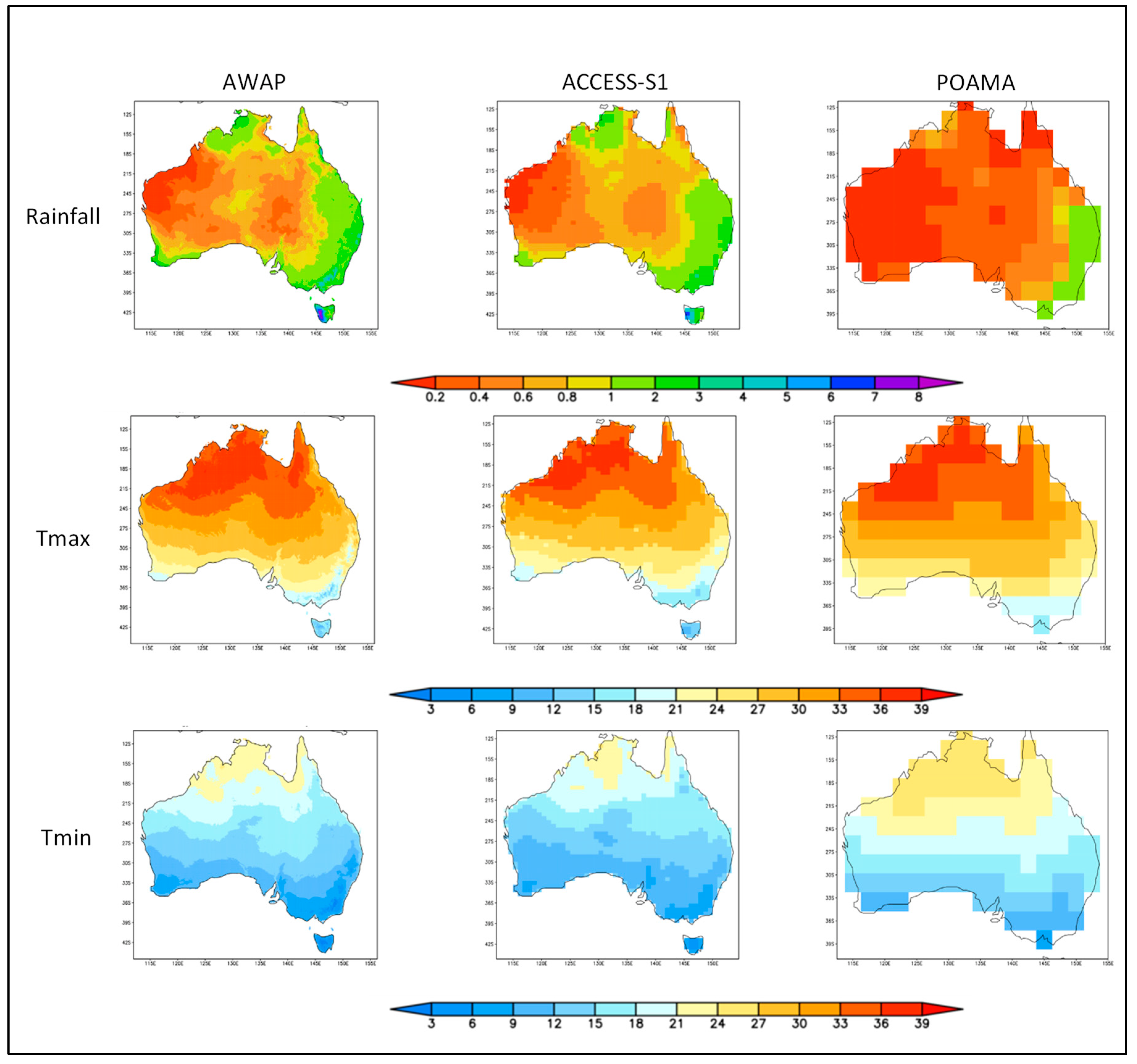
The BOM Atmospheric high-resolution Regional Reanalysis for Australia “BARRA” (Jakob et al. [15]) was the first high-resolution re-analysis dataset for Australia. Limited to 1990–2018 and with 12 × 12 km horizontal resolution over the entire continent and 1.5 × 1.5 km resolution over four smaller sub-domains, it currently trails the AGCD analyses in resolution and extent. Notably, however, BARRA also includes 70 vertical levels that extend into the upper atmosphere (21 of which are available as standard outputs) plus four levels of soil moisture, and has hourly gridded values for each of the numerous variables available throughout the 1990–2018 re-analysis period. It is understood that plans are underway for the extension of this re-analysis dataset, aiming for higher resolution over a larger domain and spanning a longer period of years. Eventually, a blending of BARRA-style outputs with AGCD outputs will help optimise improvements in long-term gridded analyses.

4.2. Seasonal to Interannual Forecasts

4.2.1. Forecasting of Soil Moisture

Until recently, routine operational predictions of soil moisture have not been available. The development of AWRA-L (Frost et al. [6]) as outlined in Section 3.1.1 has provided routine operational daily estimates of soil moisture. This opens the possibility of producing routine operational seasonal soil moisture forecasts. Work commissioned for Sydney Water (Frost et al. [16]) established a methodology for linking AWRA-L to ACCESS-S1 that can produce downscaled 5 × 5 km resolution forecasts of soil moisture for all of Australia, up to six months lead time. An assessment of hindcast performance of the 5 × 5 km downscaled ACCESS-S1 outputs (Griffiths et al. [17]) showed that the downscaling method effectively reduced model bias and produced daily estimates possessing variability consistent with daily observations, rendering the output suitable for AWRA-L input without introducing new systematic errors. Soil moisture results from the ACCESS-S1–AWRA-L integration showed that for hindcasts spanning 1990–2006, over a narrow geographic domain centred on Sydney, performance was strong in the first month of lead time but then faded gradually in spring and summer, and more rapidly in autumn and winter.
Notably however, ACCESS-S1 has a soil moisture field that is initialised based on climatology, rather than on observational estimates. Zhao et al. [18] performed hindcast experiments over the period 1991–2012 and showed that soil moisture initialisation based on realistic observational estimates of soil moisture led to moderate to significant improvements in the forecasting of input variables required by AWRA-L. This points to expected improvements in soil moisture forecasting performance when AWRA-L is coupled with ACCESS-S2, which is now operational and initialised with a soil moisture field based on observational estimates.

4.2.2. Forecasting of Evapotranspiration

Evapotranspiration is an important measure of the loss of water from plants and soil due to evaporation, hence evapotranspiration predictions are extremely useful.
Like soil moisture, issues around the complexity of calculation and the sparsity of underlying data source networks have until recently hindered the routine production of gridded evapotranspiration estimates. AWRA-L now produces routine operational daily historic estimates of evapotranspiration at 5 × 5 km resolution across Australia. Moreover, dynamic coupled ocean–atmosphere models, such as ACCESS-S, routinely calculate estimated evapotranspiration as part of their land–atmosphere energy balance calculations. Nguyen et al. [19] made an assessment of evapotranspiration hindcasts using ACCESS-S1 at its native 60 × 60 km resolution up to a six-month lead time over a hindcast period of 1990–2012. Moderate skill in the prediction of evapotranspiration was observed. Limited experiments using realistic observation-based soil moisture initialisation produced improved forecasts, consistent with the findings of Zhao et al. [18] who pointed to expected improvements in evapotranspiration forecasts with ACCESS-S2 given its observation-based initialisation of soil moisture.
Furthermore, Nguyen et al. [19] recommended coupling 5 × 5 km downscaled ACCESS-S1 with AWRA-L to produce 5 × 5 km evapotranspiration forecasts. Proof-of-concept work on this by Frost et al. [16] showed similar promising performance to soil moisture forecasts, outlined in Section 4.2.1, which should be markedly improved when AWRA_L is coupled with downscaled ACCESS-S2 outputs.

4.2.3. The Problem of Identifying Drought Onset

The operational prediction of drought onset is a major challenge to the utility of drought early warning systems. Recent Australian research (Nguyen et al. [20]) examines a short term, rapid onset dimension to drought called “Flash Drought” using the Evaporative Stress Index (ESI—the standardised anomaly in the ratio between actual and potential evapotranspiration). Hindcast results showed the potential for flash drought pre-warning of a few weeks, which would be very valuable for timing the execution of short term on-farm decisions, such as when to plant or fertilise and in particular when to irrigate.
The abovementioned methodology for linking AWRA-L to ACCESS-S1 to produce forecasts of AWRA-L parameters (Frost et al. [16]) could be used for making the ESI calculation. Thus, a proxy for ESI could be forecast to extend the lead time for predictions of flash drought onset. Further research is required to establish such a capability, and to reveal the climatological relationship between flash drought and the onset of longer-term widespread droughts, as well as the extent to which ESI may be applicable (or not) to predicting these.

4.2.4. Drought Duration and Multi-Year Forecasts

Single year El Niño phases with IOD coupling have commonly in the past run from the austral autumn/winter through to the following autumn. With a current operational lead time of up to only six months, even when autumn is within the lead time window, considerable uncertainty may remain in terms of the quantitative prospects of cessation of meteorological drought, and even more uncertainty with respect to agricultural drought. Most statements regarding the predicted cessation of agricultural drought have remained heavily qualitative. The need for prediction of drought cessation has compounded in recent decades, due to a rise in the frequency of multi-year droughts in Australia. Moreover, projections of climate change indicate that multi-year droughts are likely to become more frequent and severe under a range of GHG emissions scenarios. Hence, to provide useful estimates of predicted drought duration and cessation, multi-year forecasts will be required.
An operational multi-year climatological forecasting capability does not exist at present in Australia. Experimental dynamic coupled-model-based hindcast outputs from the UK Meteorological Office with up to 5.5 years lead time (Sheen et al. [21]) were assessed to gauge the potential for developing and using multi-year ACCESS-S forecasts (based on the same underlying model) in Australia (Luo et al. [22]). An 11-member ensemble of global 5.5 year lead time hindcasts was used, commencing in November of every other and then every third year from 1960 to 2014, at a horizontal resolution of 60 × 60 km over land, and 25 × 25 km over the oceans. It was found that although the mean and seasonal cycles of ocean and atmospheric surface temperatures, precipitation, and winds were realistically reproduced across the Indo-Pacific area and Australia, already known model biases persisted. These included winter to spring errors in east–west temperature differential across the tropical Indian Ocean, tropical rainfall less than observed over the eastern Indian Ocean but more than observed over the tropical western Pacific, and colder than observed surface ocean temperatures in the eastern Pacific. These biases caused the strength of ENSO to be overpredicted in the first three month forecast period and underpredicted at lead times exceeding 12 months, whilst the IOD tended to be overpredicted in the first 12 months and then underpredicted for longer lead times. Despite this, overall seasonal variability was well simulated, including the season cycles of ENSO and IOD, indicating that predictions of ENSO–IOD combinations that induce drought were more skillful than using climatology. In terms of specific parameters, surface ocean temperatures in key areas of the Pacific and Indian Oceans were skillfully predicted out to approximately 16 months, and surface air temperature predictions for above/below the climatological median were found to be 70% correct at three years, 52% at four years and 56% at five years lead time. However, skillful prediction of rainfall beyond one year remained challenging.
Luo et al. [22] concluded that concerted research and development efforts could reduce the abovementioned biases, leading to improved multi-year predictability. The authors concur with their recommendations that in the next upgrade from ACCESS-S1 to S2 (which has just become operational) model runs should be routinely extended to at least 1.5 years lead time, with periodic longer runs to 3 years and 5 years lead time. Doing so alongside ongoing work on predicting drought onset and cessation would lead to a major step-change in the basic information underpinning drought early warning systems. Similarly, longer lead time ACCESS-S forecasts could be used to drive multi-year hydrological streamflow forecasts, and this should be pursued alongside other statistically based approaches to produce operational multi-year streamflow projections.

4.3. Climate Change Projections

To drive uptake, performance and relevance for decision-making related to adaptation and mitigation at local to regional scale, finer spatial and temporal resolution projection data is required. This is especially the case where topographic variations, coastal boundaries and physical processes vary significantly at distances below the grid-scale of GCMs. Running GCMs at the required resolution is out of reach for the current generation of computing technology. RCM downscaling provides the best alternative for bridging this gap. According to a detailed study by CSIRO and BOM [23] “there is currently no set of systematically produced GCM-RCM climate projections available that covers the entire (Australian) continent”, and “currently there is no fully representative and complete GCM-RCM dataset suitable for quantitative analysis to accompany these regional insights.”
However, with further development and investment, this is now within reach. Its realisations would meet a pressing need for detailed quantitative analyses of regional- to local-scale insights on likely drought extent, severity and duration. Transdisciplinary work should be undertaken to incorporate such information to help improve impact-based projections. To be useful, impact projections need to be integrated into stakeholder decision-making systems with explicit quantification of any projection uncertainty.

4.4. Integration of Seasonal Weather Forecasts with Production Models

While meteorological data is key to understanding the underlying drivers of drought, the manifestation of drought and its impacts are reflected in measures of environmental, crop, pasture and animal health. Reports such as the NSW State Seasonal Update (NSW DPI [24]) seek to audit the situation at a particular time from an agricultural perspective. This report combines meteorological data and satellite observations such as Normalised Vegetation Index (NDVI) with information such as pasture availability and soil moisture, from third parties. In recent times new technologies have emerged such as the Internet-Of-Things (including sensors on farm machinery), drones, and satellite-based remote sensing, with potential to automatically compliment and add to this information. Localised usage and organised private networks exploiting these new technologies are becoming more widespread. Thus, third party data is likely to become very important in this domain for the development of comprehensive datasets that can be used as input for models, algorithms and indices, such as the Combined Drought Index mentioned above, to detect and monitor drought.
Yet this still does not go far enough to achieve a comprehensive measurement of drought and its impacts. Integrated drought monitoring systems are required that couple multiple climate, water, soil and crop parameters, socio-economic, and environmental indicators and indices to fully characterize the magnitude, spatial extent, trends, duration, and impacts of droughts. This calls for more extensive integration of climatological datasets with relevant ecological, social and economic data.
The next step in terms of developing more precise analytical decision-making tools, as opposed to heuristics that aid only non-quantifiable judgements, is to integrate climate forecasts into production models. A number of sophisticated production models (e.g., APSIM, GRASSGRO) to predict output under a range of input levels have been developed for Australian cropping and livestock systems. These models integrate weather forecast data with production simulations to aid farm-level decision-making. These and other simpler models may benefit from modification to output production functions that measure yield or dry matter production in response to input variables at farm level. As suggested above in Section 4.2.1, the starting point would be to use forecast soil moisture as a proxy for plant available water, and input this into crop-specific simulation models.
The key underlying relationships embedded in these simulation models can provide a production function that measures the various levels of physical output or yield (the dependent variable) to various levels of inputs (the independent variables). If we assume soil moisture is the key independent variable, then under ceteris paribus conditions, Figure 2 below illustrates the classical production function model reflecting the behaviour of most agricultural crops.
The vertical axis measures the level of total product (TP), average product (AP) and marginal product (MP) for each level of input on the horizontal axis, which in the case of a simple drought monitoring system may be soil moisture. The TP curve (in red), or total production function as it is known, exhibits three distinct stages. In Stage 1 output increases at an increasing rate as more soil moisture becomes available, to point A in Figure 2. The convex inflexion point (A) on the TP function defines the maximum level of marginal productivity (the rate at which output increases relative to input level), after which marginal productivity starts to decline. A second (concave) inflection point (B) on the TP function describes a level of input where average product peaks, after which it also starts to decline. That is, addition of more inputs results in increasingly lower additional output. At this point marginal product MP (in green) also falls below average product AP (in blue) at point (E), so the increase in product as a result of more input becomes smaller and smaller. The addition of more input after this inflection point increases total product, but in ever smaller amounts; this is known in economics as the region of diminishing returns (Stage II—shaded pink). At point C the production function peaks, this maxima is the absolute limit of the technical production capability of the crop, after which output declines with increasing input (Stage III). Returns beyond this point decrease TP. MP also falls below zero (F), which means that any increase in input actually causes TP to decline (this would correspond with the soil being saturated to the point where it inhibited plant growth or grain fill). This type of production function, reflecting a response curve such as the one illustrated in Figure 2, will be the central component of the production model.
By applying known or estimated current sale prices to outputs and the costs of other variable inputs, a benchmark gross margin at median soil moisture for a specific crop in a specific location could theoretically be calculated. If probabilistic soil moisture forecast data (for instance, the chance of exceeding or being less than the median) is then put into the production function model, a production output could be estimated and compared with the output for median soil moisture. Applying current prices and costs, the farmer could see the impact that forecast soil moisture would have on the crop or livestock gross margin. If a probabilistic forecast of exceeding median soil moisture, or its inverse of failing to reach median soil moisture, were then applied, the farmer would have a simple probabilistically based gross margin heuristic with which to assess drought risk.
However, this may not be the only information of value generated by such an integrated model. Knowledge of the production function combined with marginal analysis might also be used to generate other new heuristics. Using calculus, the point can be determined at which profits are maximised for any given production function—where the partial derivative (or slope) of the production function equals the ratio of the input factor price to the price of the output product. With a normal production function, the concave section of the curve exhibiting diminishing returns (Stage II) is where the profit maximising level of any input generally falls. This is between the part of the TP function above the concave inflection point (B) in Figure 2, (where diminishing returns start to set in) and the peak of the curve, or the point of maximum technical efficiency (C). Without a known market price for moisture (in the case of dryland farming), it may be difficult to calculate precisely the point of profit maximization, but provided the output for the range of soil moisture levels forecast falls within the range defined above (B to C on the TP curve in Figure 2) at least some profit is possible.
The next step would be to apply economic marginal analysis to assess if the impacts of specific management decisions are worthwhile, such as adding fertiliser or directly altering other inputs. This would, in theory at least, enable clear-cut quantitative estimates of output for various scenarios of forecast soil moisture, to give farmers a very powerful decision-making tool. It would be able to guide a farmer in deciding, for example, whether or not to grow a crop that season, whether to add other mid-season variable inputs such as nitrogen fertilizer to an in-ground crop, whether to graze or grow the crop through to grain harvest, etc. These are vitally important management decisions, for which farmers have to date relied mainly on more simple and less informative qualitative heuristics.
More powerful decision-making tools could more fully integrate the probability distribution function of soil moisture from a particular seasonal forecast. Having already identified the soil moisture levels corresponding to points E (from which diminishing returns increase) and F (where marginal production turns negative and output is maximised) in Figure 2, we can use the forecast soil moisture probability distribution to calculate the probability of achieving soil moisture within this range—that is, within the preferred Stage II of the production function, where a worthwhile return stands to be made from the crop. It is then a question of risk management for the farmer to select a decision threshold suitable to the ensuing circumstances and decision choices available.
Also critical in situations of water shortage, such as drought, is to consider whether forecast soil moisture (that is, rainfall driven soil moisture plus already stored soil moisture) falls short, or is close to falling short of point E. This could be represented by criteria such as the point when the probability of forecast soil moisture above E falls below a nominal threshold. Again, the threshold would be set by the farmer in view of their overall financial and production-related risks. Where irrigation or in the case of small intensive crops, water cartage, might be an option; the decision as to whether the cost of adding sufficient water to bring crop output comfortably into Stage II, could be supported. With regard to irrigation, seasonal streamflow forecasts could provide information about the likelihood of river flows and dam inflows being sufficient during the forecast period to support irrigation offtakes.
The above steps, framed in terms of integrating soil moisture forecasts with production models, could be recast in terms of integrating evapotranspiration forecasts, to help support irrigation, fertilizer application and other relevant decisions. Production of guidance from soil moisture and evapotranspiration forecasts would be a major step forward in the enhancement of drought early warning systems.
Going further still, underpinned by dynamic seasonal models, it is now possible to produce forecast probability density functions (PDF) for all the meteorological data required for production models. These include temperature, rainfall, wind, evapotranspiration, soil moisture, and so on. Given the complex interrelationships between these variables, the full integration of their paired PDFs into production models would be quite complex. However, with further research and development it may be possible. If so, this would result in predicted PDFs of TP, AP and MP, with options for running scenarios with varying management-decision inputs such as irrigation. The results would be used to generate guidance on theoretically optimal input levels.

4.5. Communication

In recent years, government drought policy and interventions have continued in the direction of self-reliance, but substantially higher levels of self-reliance have remained elusive. Setting aside the accuracy of predictions embodied in drought early warning systems, the communication of information in terms that users can readily understand and incorporate into their decision making has been a major factor in this.
Commonly, Australian farmers have a basic understanding of the El Niño–La Niña cycle in the Pacific Ocean. Even in geographic areas where ENSO events are known to have less direct influence on weather, farmers watch and discuss ENSO phases. Many understand some of the key heuristics employed to interpret the relative strength of the phases, such as the Southern Oscillation Index or tropical Pacific Ocean temperature indices, and some avidly follow their scores above or below a neutral benchmark. Most take precautions in planning production decisions when an El Niño is forecast. At least some credit for this lies with the widespread availability and awareness of seasonal forecasts, improvements in their performance and presentation over time, and extensive educational efforts regarding their relevance and impact.
There is growing awareness amongst producers about the impact of the IOD, following educational efforts and inclusion of commentary in seasonal forecasts, especially after the severe 2018–19 IOD-driven drought. Regarding SAM and MJO, whilst awareness is slowly growing, few farmers have more than a cursory understanding of these phenomena. Overall, amongst farmers there appears to be generally little understanding of the interactions between the four major climate drivers in determining net impact on local weather. This is not surprising, because there is an inherently high level of complexity in each of these phenomena, their interactions, and the spatio-temporal variability of resultant weather patterns. Some of this complexity is reflected in the configuration, performance and outputs of the models used to produce seasonal predictions of weather parameters, and in the prediction of downstream impacts, such as soil moisture or streamflow.
To increase user adoption will be useful to raise awareness and understanding of underlying climate drivers and model performance characteristics for users’ own locations. However, complexities in the raw weather variable output often render the information confusing and too difficult to effectively apply in decision-making. Further education aimed at advancing understanding among farmers and other stakeholders is unlikely effectively to increase self-reliance. Rather, a tiered set of outputs is needed for specific locations and specific crops and livestock, such as those proposed in Section 4.4, that with the right presentation and framing, producers could readily understand in the context of their drought-related decision-making, and around which they could develop new heuristics.
Initially this could be through forecasts of variables directly relevant to decisions, such as soil moisture or stream flow. This could extend in turn to predictions of newly defined drought indices, like the CDI. Finally, it should flow through to comprehensive and targeted Decision Support Systems that integrate seasonal climate forecasts with production models, as outlined in Section 4.4, at farm level for producers, and for other stakeholders across the various components of agricultural value chains.

5. Conclusions and Recommendations

At present, policy inputs remain mostly retrospective or based upon the current observed state. Predictively based science and technology have now reached or are approaching a point where drought early warning systems are possible primarily based on predictive inputs, with historic verification and contextualisation. Every effort should now be made to continue moving in this direction, to improve the effectiveness and value of drought early warning systems. Doing so stands to dramatically improve the resilience and self-reliance of those affected by drought, and to minimise the widespread negative economic and social impacts of drought, guiding policy to address more effectively the adverse consequences of drought.
Limitations in the resolution of outputs and length of lead times remain a barrier to the adoption and usage of seasonal forecasts of standard climatological variables, streamflow, and dam inflows, in drought-related decision-making. The temporal resolution of outputs should correspond to intervals relevant to key decisions for specific crops and livestock, and the extension of lead times should cover at least an entire growing season. With further research and development, multi-year lead times are becoming within reach and would be of enormous benefit for multi-year planning in the face of increasingly frequent multi-year drought episodes. Certain complex drought measures are currently monitored on a real-time or historical basis and require meteorological inputs, such as soil moisture, evapotranspiration and the Combined Drought Index; these should be moved to a predictive footing to allow users the benefit of early warning.
Accepting that improved resilience and self-reliance of users (including but not limited to agricultural producers, agribusinesses, water managers, rural communities, and other stakeholders affected by drought) is the goal of drought early warning systems, user education is essential along with the provision of application frameworks and user-friendly tools. This is especially so, considering most users have little if any formal training or experience in climate science or the application of uncertain probabilistic information to decision-making. The latter is particularly pertinent given that the probability given by a prediction system of an event occurring is in turn overlaid by the probability or level of confidence that the system itself is reliable. Straight event probabilities are often very challenging for users to correctly interpret. Conditional confidence probabilities are far more difficult to factor in, especially if several different models are integrated to provide a result. This is a major barrier that needs to be overcome to allow the adoption and correct usage of future drought early warning information systems.
The same can be said with more emphasis about long-term climate projections, where the uncertainties are greater and complexity is higher. Overlaid on the ensemble probabilities are the differing levels of reliability of each of the contributing GCMs and RCMs, plus the uncertainty associated with the likelihood of the emissions scenarios themselves. A common and comprehensive methodology should be developed and agreed upon either to relate uncertainty information to users, or for users to carry out self-assessment. The results need to be readily comprehensible by non-specialist users, so that they can readily factor climate-related risks and information directly into their decision-making and decision support systems.
Outputs more directly related to decisions are required to drive uptake, usage and the realisation of benefits. Key to this is the integration of seasonal climate model outputs into decision support and production models, to produce impact-based forecasts specific to particular crop production, livestock capacity, and irrigation needs. Critically, tools should be provided that allow producers directly to set their own farming, business and financial thresholds, in order to explore the likely production and financial consequences of various tactical and strategic decisions.
This calls for a unification of efforts across institutions and disciplines, to produce seamless information spanning all of Australia. It needs to also cover timeframes from historical to current for detection and contextualisation, including seasonal and multi-year probabilistic predictions that support tactical and strategic decisions, and climate change projections for determining the scale and direction of long-term research and infrastructure investments, to ensure future resilience and sustainability. Information for each temporal domain should include explicit measures of uncertainty, a framework for end-user analysis, application and integration into decision-making and decision support systems, and sector- and activity-specific results and tools. Such unification could be achieved through a single hub, because at present information tends to be widely dispersed across numerous organisations and websites. This dispersion renders very difficult the development of a comprehensive understanding of available information and a consistently robust application of information to decision making, for the majority of users.
Aside from substantial investments in scientific development, tighter institutional collaboration, digital integration, and online accessibility of information, it should not be forgotten that substantial high-performance computing infrastructure and related expertise will also be required. With such further investments, the abovementioned gains are now within reach of current science and technological advancement. If achieved they will enable a step-change in drought-related policy, shifting it from a primarily retrospectively based to a primarily predictively based approach with early warning at its core. This will shift action from reaction and response to events as they happen, to a more proactive planning-based footing.

Funding

This research received no external funding.

Institutional Review Board Statement

Not applicable.

Informed Consent Statement

Not applicable.

Data Availability Statement

Not applicable.

Conflicts of Interest

The authors declare no conflict of interest.

References

  1. Laughlin, G.; Clark, A. Drought Science and Drought Policy in Australia: A Risk Management Perspective. In Proceedings of the World Meteorological Organisation Expert Group Meeting on Early Warning Systems for Drought Preparedness and Drought Management, Lisbon, Portugal, 5–7 September 2000; pp. 32–44. [Google Scholar]
  2. Stone, R.C. Constructing a Framework for National Drought Policy: The Way Forward—The Way Australia Developed and Implemented the National Drought Policy. Weather. Clim. Extrem. 2014, 3, 117–125. [Google Scholar] [CrossRef] [Green Version]
  3. UNISDR. Drought Risk Reduction Framework and Practices: Contributing to the Implementation of the Hyogo Framework for Action; United Nations Secretariat of the International Strategy for Disaster Reduction (UNISDR): Geneva, Switzerland, 2009; 213p. [Google Scholar]
  4. Wilhite, D.A.; Glantz, M.H. Understanding the drought phenomenon: The role of definitions. Water Int. 1985, 10, 111–120. [Google Scholar] [CrossRef] [Green Version]
  5. Evans, A.; Jones, D.; Smalley, R.; Lellyett, S. An Enhanced Gridded Rainfall Analysis Scheme for Australia; Bureau Research Report No. 041; Bureau of Meteorology: Melbourne, Australia, 2020.
  6. Jones, D.A.; Weymouth, G. An Australian Monthly Rainfall Dataset; Bureau Technical Report No. 70; Bureau of Meteorology: Melbourne, Australia, 1997.
  7. Jones, D.A.; Wang, W.; Fawcett, R. High-quality spatial climate data-sets for Australia. Aust. Meteorol. Oceanogr. J. 2009, 58, 233–248. [Google Scholar] [CrossRef]
  8. Frost, A.J.; Ramchurn, A.; Smith, A. The Bureau’s Operational AWRA Landscape (AWRA-L) Model; Bureau Technical Report; Bureau of Meteorology: Melbourne, Australia, 2016.
  9. Lewis, S.C.; Karoly, D.J. Anthropogenic contributions to Australia’s record summer temperatures of 2013. Geophys. Res. Lett. 2013, 40, 3708–3709. [Google Scholar] [CrossRef] [Green Version]
  10. World Meteorological Organization (WMO); Global Water Partnership (GWP). Handbook of Drought Indicators and Indices (M. Svoboda and B.A. Fuchs); Integrated Drought Management Programme (IDMP), Integrated Drought Management Tools and Guidelines Series 2; World Meteorological Organisation: Geneva, Switzerland, 2016. [Google Scholar]
  11. Clark, A.J.; McGowen, I.M.; Crean, J.J.; Lines-Kelly, R.; Wang, B. Stage 1: Enhanced Drought Information System—NSW DPI Combined Drought Indicator; Technical Report; NSW Department of Primary Industries: Orange, Australia, 2017. [Google Scholar]
  12. Wang, G.; Hudson, D.; Yin, Y.; Alves, O.; Hendon, H.; Langford, S.; Liu, G.; Tseitkin, F. POAMA-2 SST Skill Assessment and Beyond. CAWCR Res. Lett. 2011, 6, 40–48. [Google Scholar]
  13. Hudson, D.; Alves, O.; Hendon, H.H.; Lim, E.; Liu, G.; Luo, J.; MacLachlan, C.; Marshall, A.G.; Shi, L.; Wang, G.; et al. ACCESS-S1: The new Bureau of Meteorology multi-week to seasonal prediction system. J. South. Hemisph. Earth Syst. Sci. 2017, 67, 132–159. [Google Scholar] [CrossRef]
  14. IPCC. Summary for Policy Makers. In Climate Change 2021: The Physical Science Basis. Contribution of Working Group I to the Sixth Assessment Report of the IPCC; Masson-Delmotte, V., Zhai, P., Pirani, A., Connors, S.L., Péan, C., Berger, S., Caud, N., Chen, Y., Goldfarb, L., Gomis, M.I., et al., Eds.; Intergovernmental Panel on Climate Change: Geneva, Switzerland, 2021; in Press. [Google Scholar]
  15. Jakob, D.; Su, C.-H.; Eizenberg, N.; Kociuba, G.; Steinle, P.; Fox-Hughes, P.; Bettio, L. An atmospheric high-resolution regional reanalysis for Australia. Bull. Aust. Meteorol. Oceanogr. Soc. 2017, 30, 16–23. [Google Scholar]
  16. Frost, A.J.; Hendon, H.; Lellyett, S.C.; Griffiths, M. Sydney Water ACCESS-S Downscaled Seasonal Forecast/AWRA-L Project, Report to Sydney Water; Bureau of Meteorology: Melbourne, Australia, 2018.
  17. Griffiths, M.; Shi, L.; Hendon, H. Preliminary Evaluation of ACCESS-S Calibrated Predictions for the Sydney Water ACCESS-S Downscaling/AWRA-L Project; Bureau of Meteorology: Melbourne, Australia, 2017.
  18. Zhao, M.; Zhang, H.-Q.; Dharssi, I. Impact of Land-Surface Initialization on ACCESS-S1 and Comparison with POAMA; Bureau Research Report No. 023; Bureau of Meteorology: Melbourne, Australia, 2017.
  19. Nguyen, H.; Zhang, H.-Q.; Hendon, H.; Lellyett, S. ACCESS-S1 Seasonal Forecast Skill Assessment for Evapotranspiration and Other Hydro-Climate Variables over Sydney Region; Bureau Research Report; Bureau of Meteorology: Melbourne, Australia, 2017.
  20. Nguyen, H.; Wheeler, M.C.; Otkin, J.A.; Cowan, T.; Frost, A.; Stone, R. Using the evaporative stress index to monitor flash drought in Australia. Environ. Res. Lett. 2019, 14, 064016. [Google Scholar] [CrossRef] [Green Version]
  21. Sheen, K.L.; Smith, D.M.; Dunstone, N.J.; Eade, R.; Rowell, D.P.; Vellinga, M. Skilful prediction of Sahel summer rainfall on inter-annual and multi-year timescales. Nat. Commun. 2017, 8, 14966. [Google Scholar] [CrossRef] [PubMed] [Green Version]
  22. Luo, J.-J.; Nguyen, H.; Hendon, H.; Alves, O.; Liu, G.; Dunstone, N.; MacLachlan, C. Assessment of Multi-Year Climate Predictions for Potential Use by Sydney Water; Bureau of Meteorology: Melbourne, Australia, 2018.
  23. CSIRO and Bureau of Meteorology. Climate Change in Australia Information for Australia’s Natural Resource Management Regions: Technical Report; CSIRO and Bureau of Meteorology: Melbourne, Australia, 2015. [Google Scholar]
  24. NSW DPI, State Seasonal Updates Web Page, New South Wales Department of Primary Industries, Orange, Australia: February 2022. Available online: https://www.dpi.nsw.gov.au/dpi/climate/seasonal-conditions-and-drought/nsw-state-seasonal-update (accessed on 18 March 2022).
Figure 1. Comparison of spring season (SON) climatology between AWAP 5 × 5 km interpolated observation analysis (left column), ACCESS-S1 ~60 × ~60 km one month lead time climatology (middle column), and POAMA 250 × 250 km one month lead time climatology (right column) for each of Rainfall (mm/day, top row), Tmax (maximum temperature, Deg C, middle row) and Tmin (minimum temperature, Deg C, bottom row). Source: reprinted with permission from Hudson et al. [13], 2017, CSIRO Publishing.
Climate 10 00091 g001
Figure 2. Classic Model of an Agricultural Production Function.
Climate 10 00091 g002
Publisher’s Note: MDPI stays neutral with regard to jurisdictional claims in published maps and institutional affiliations.

