

A Continuous Centennial Late Glacial-Early Holocene (15–10 cal kyr BP) Palynological Record from the Iberian Pyrenees and Regional Comparisons
 , and
, and
Abstract
:1. Introduction
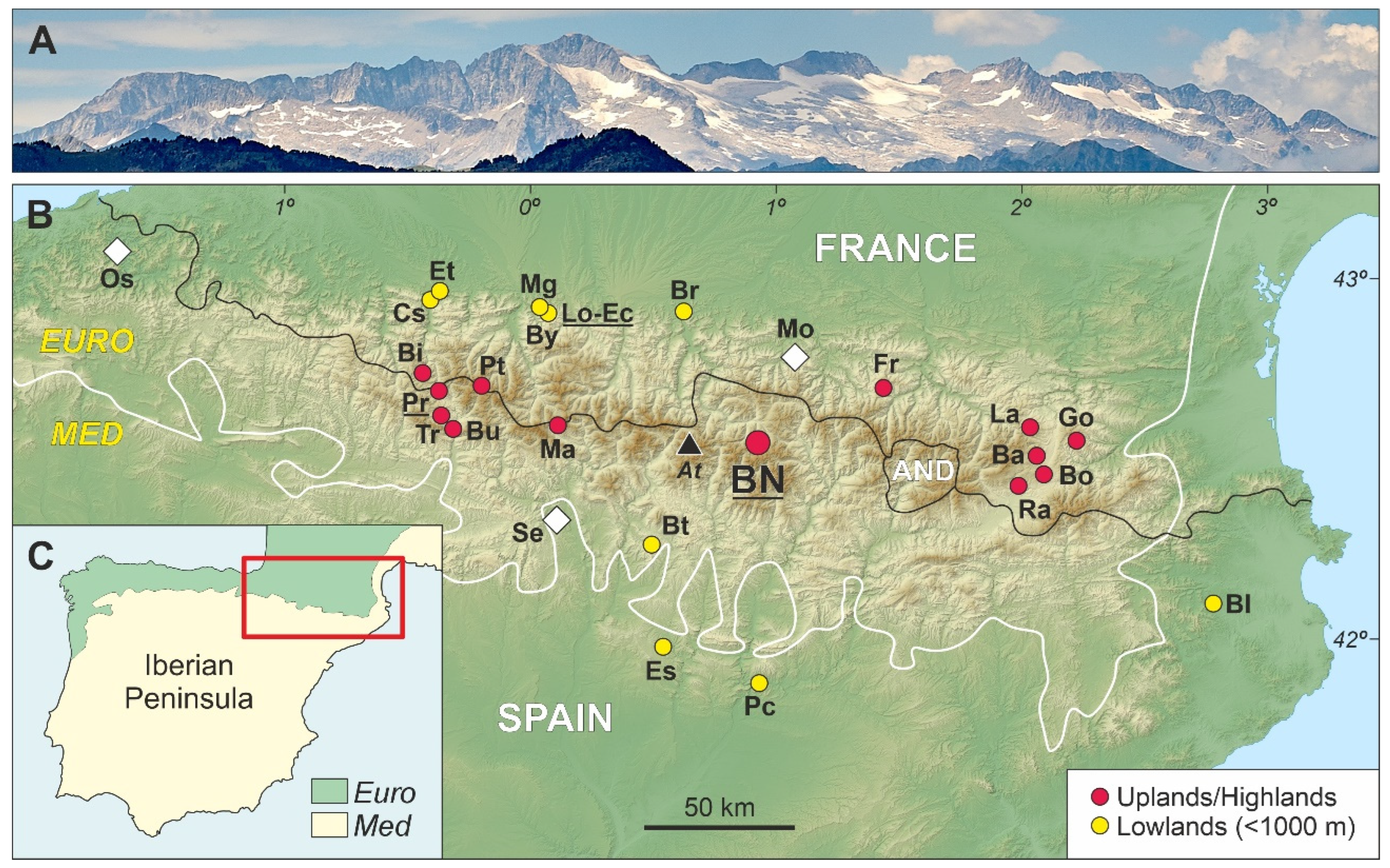
2. Study Area
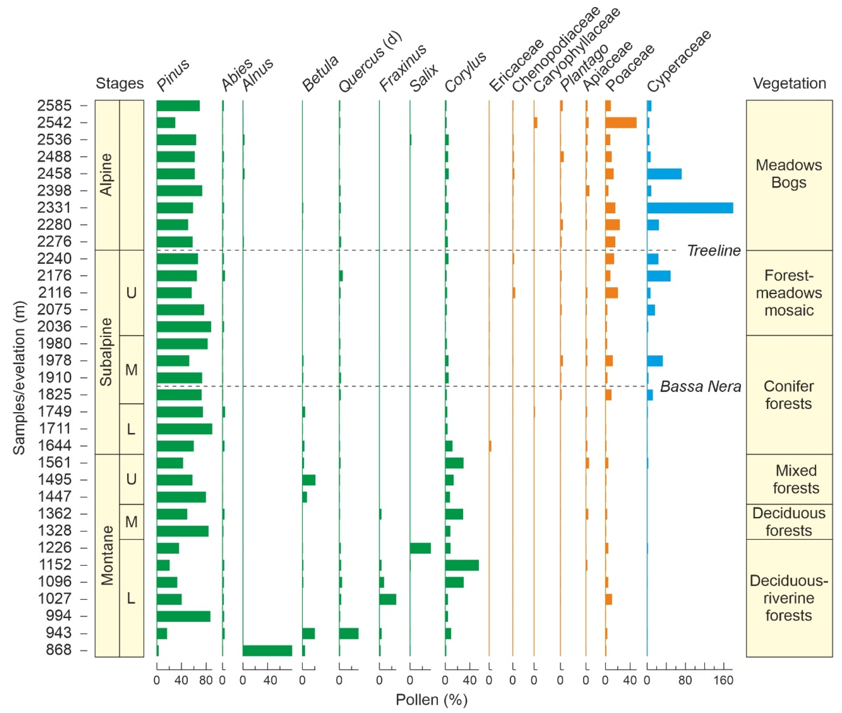
2.1. Present Conditions
2.2. Previous Studies
3. Methods
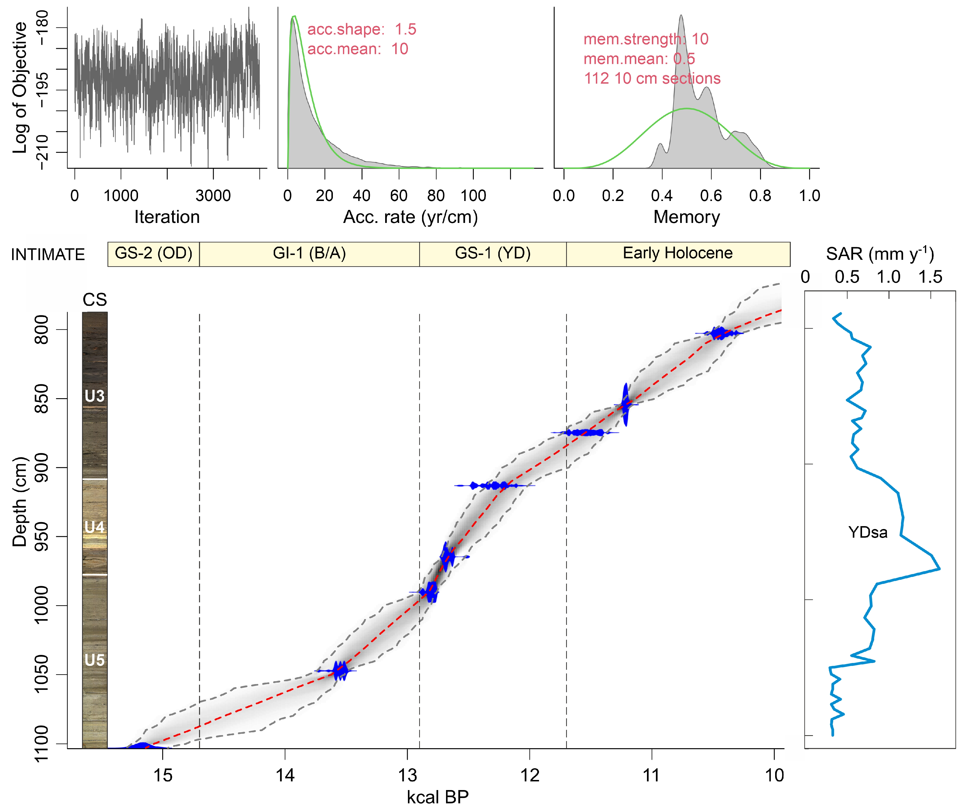
3.1. Coring and Dating
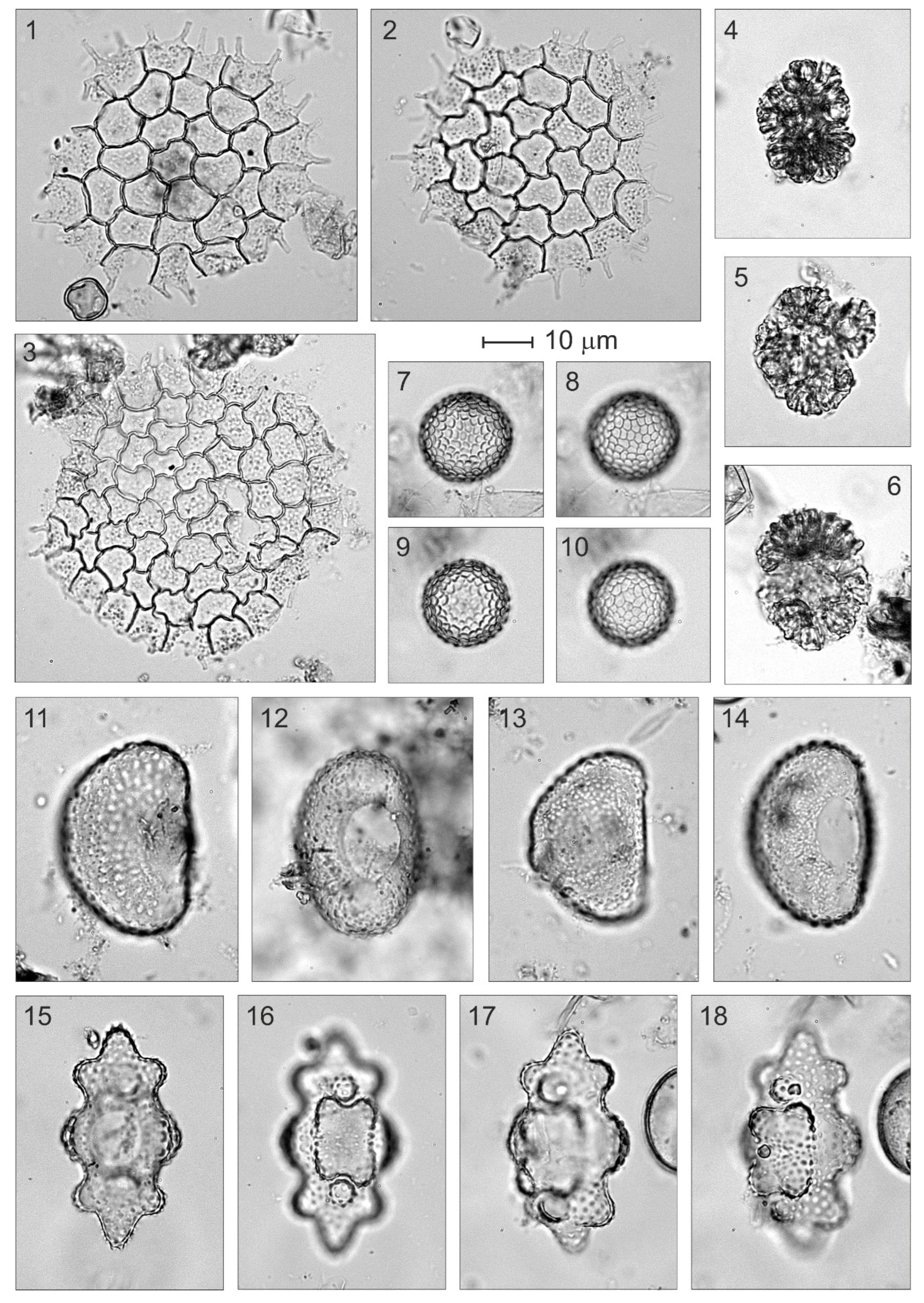
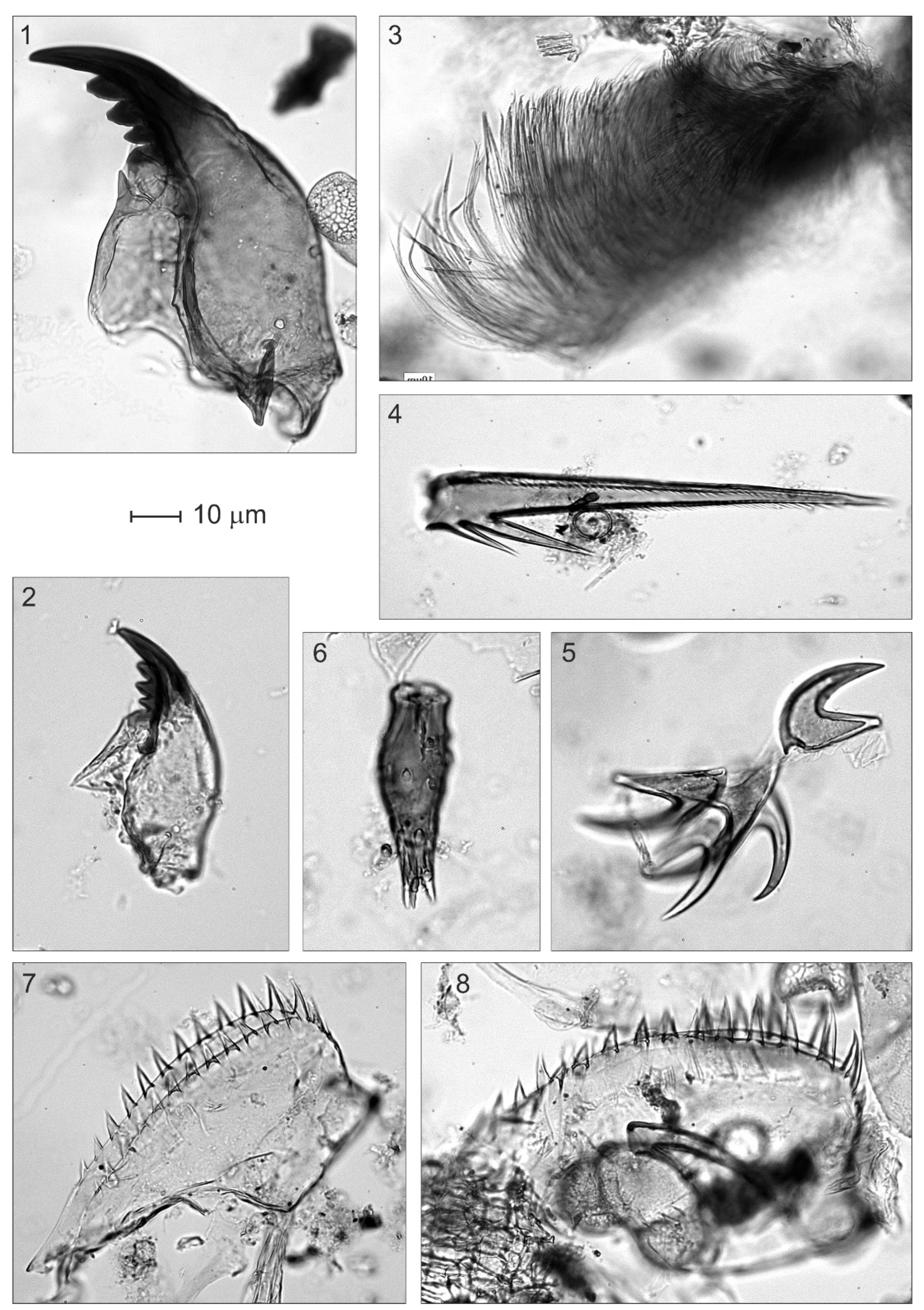
3.2. Palynological Analysis
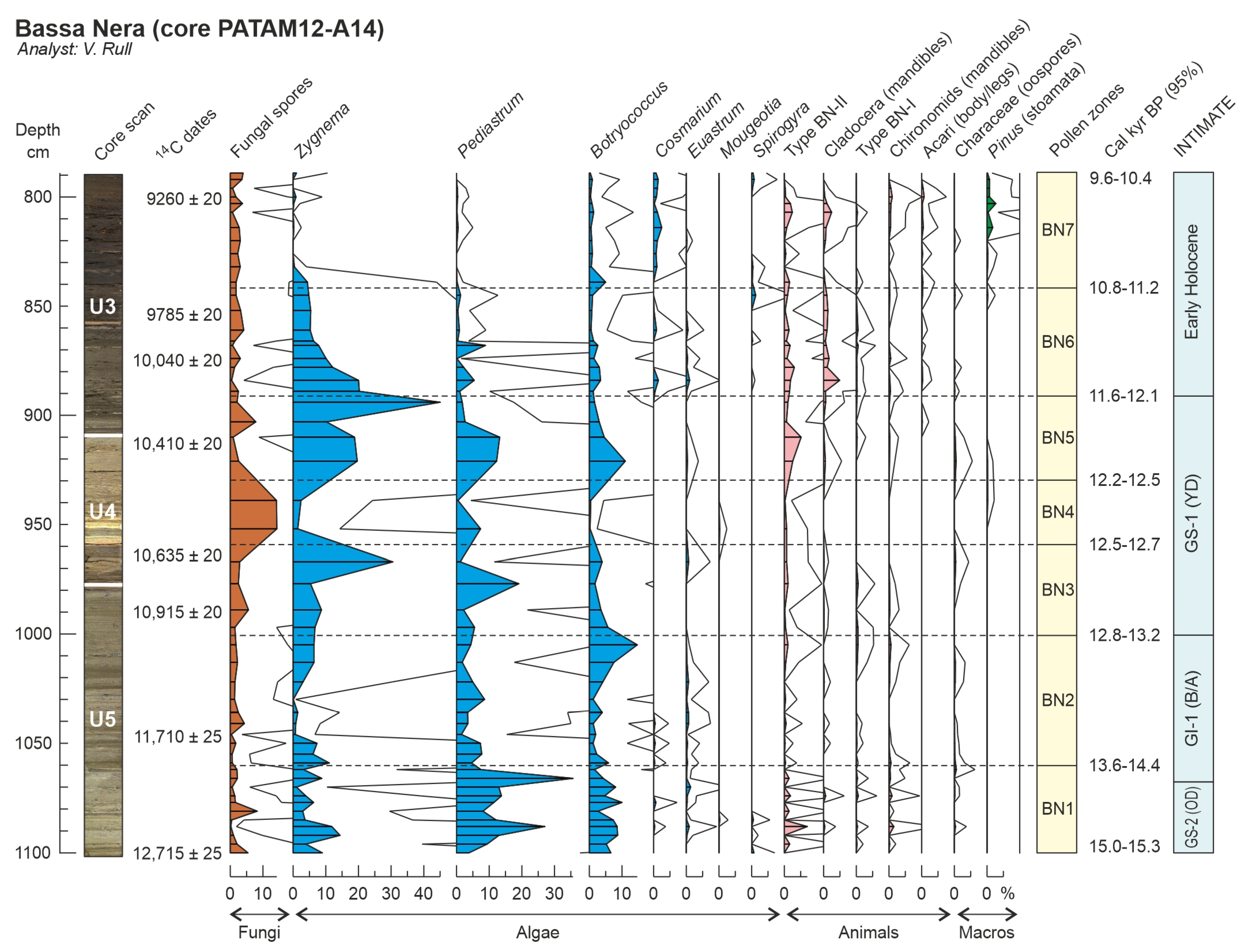
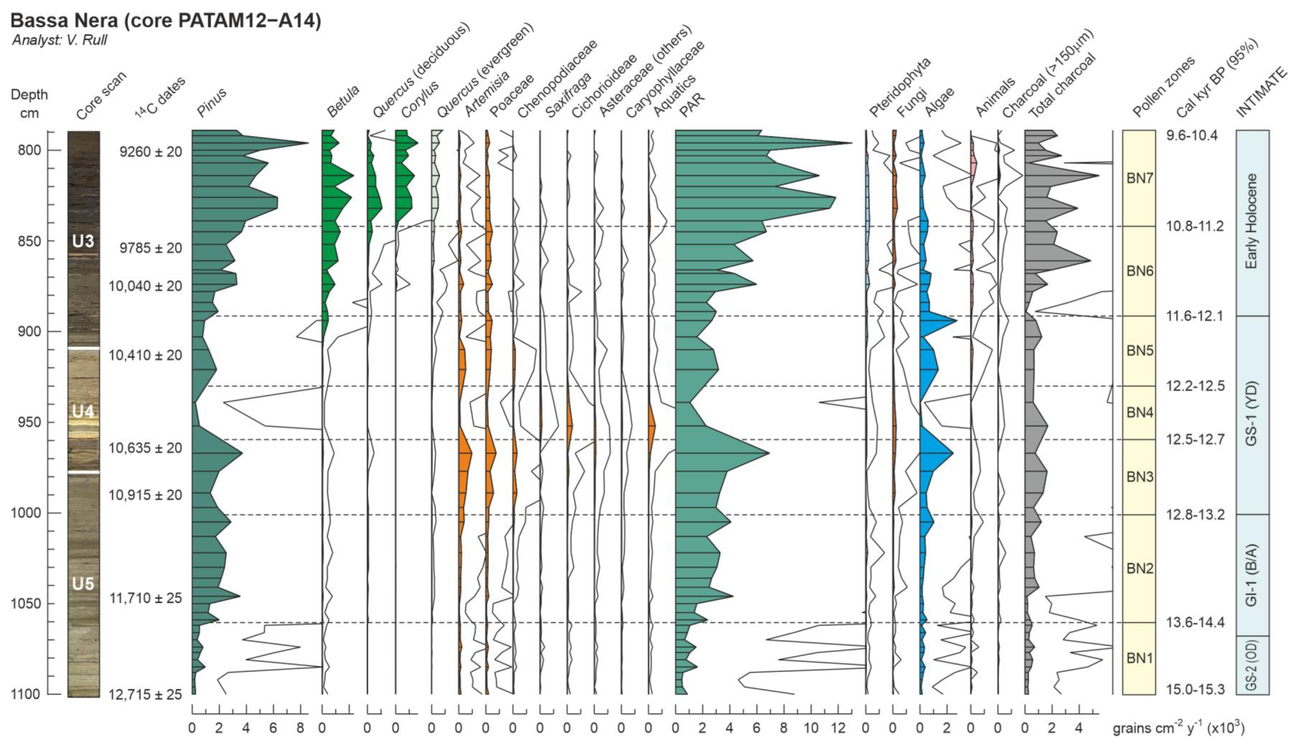
4. Results
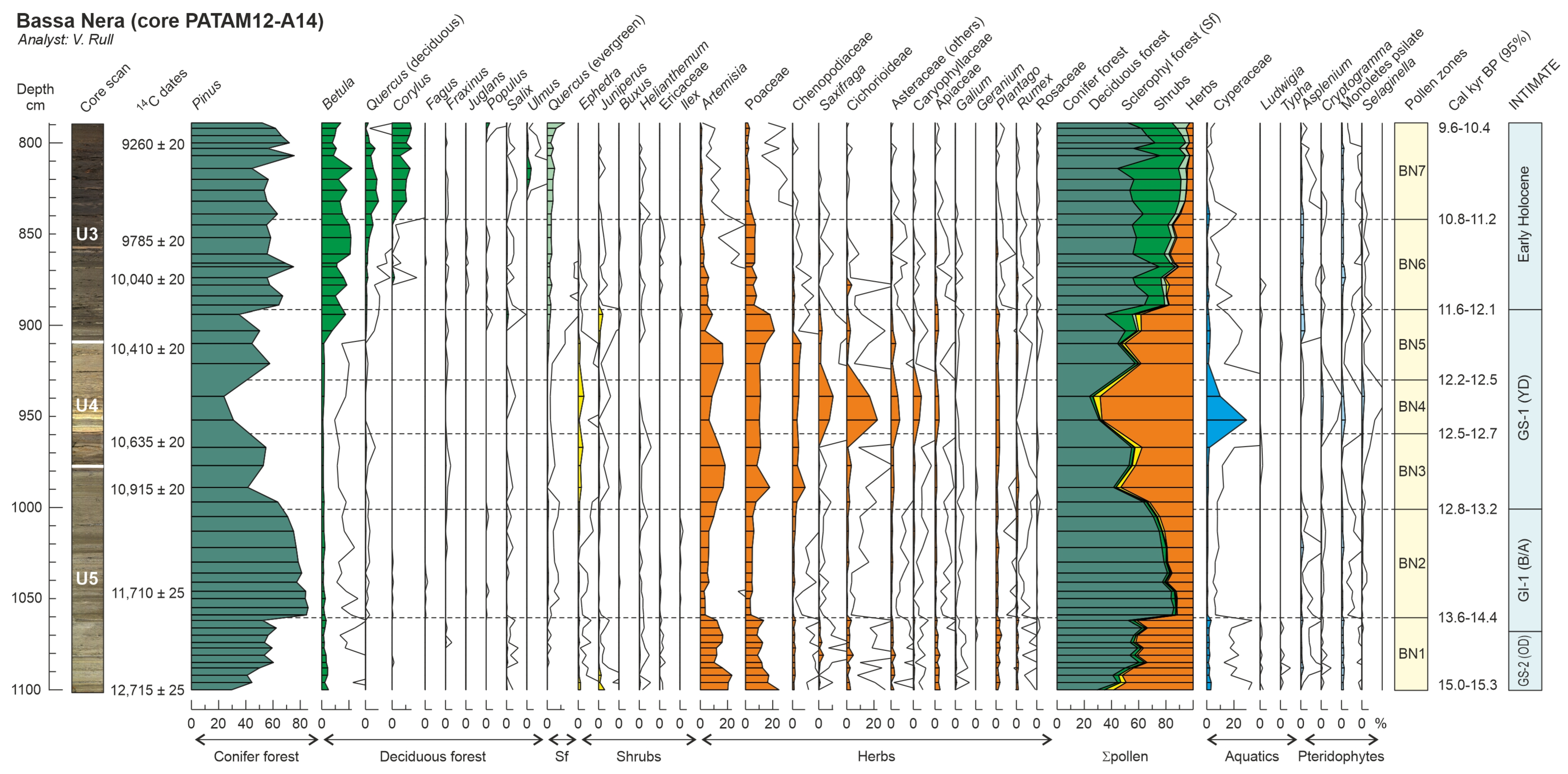
4.1. Lithology and Chronology
4.2. Palynology
5. Discussion
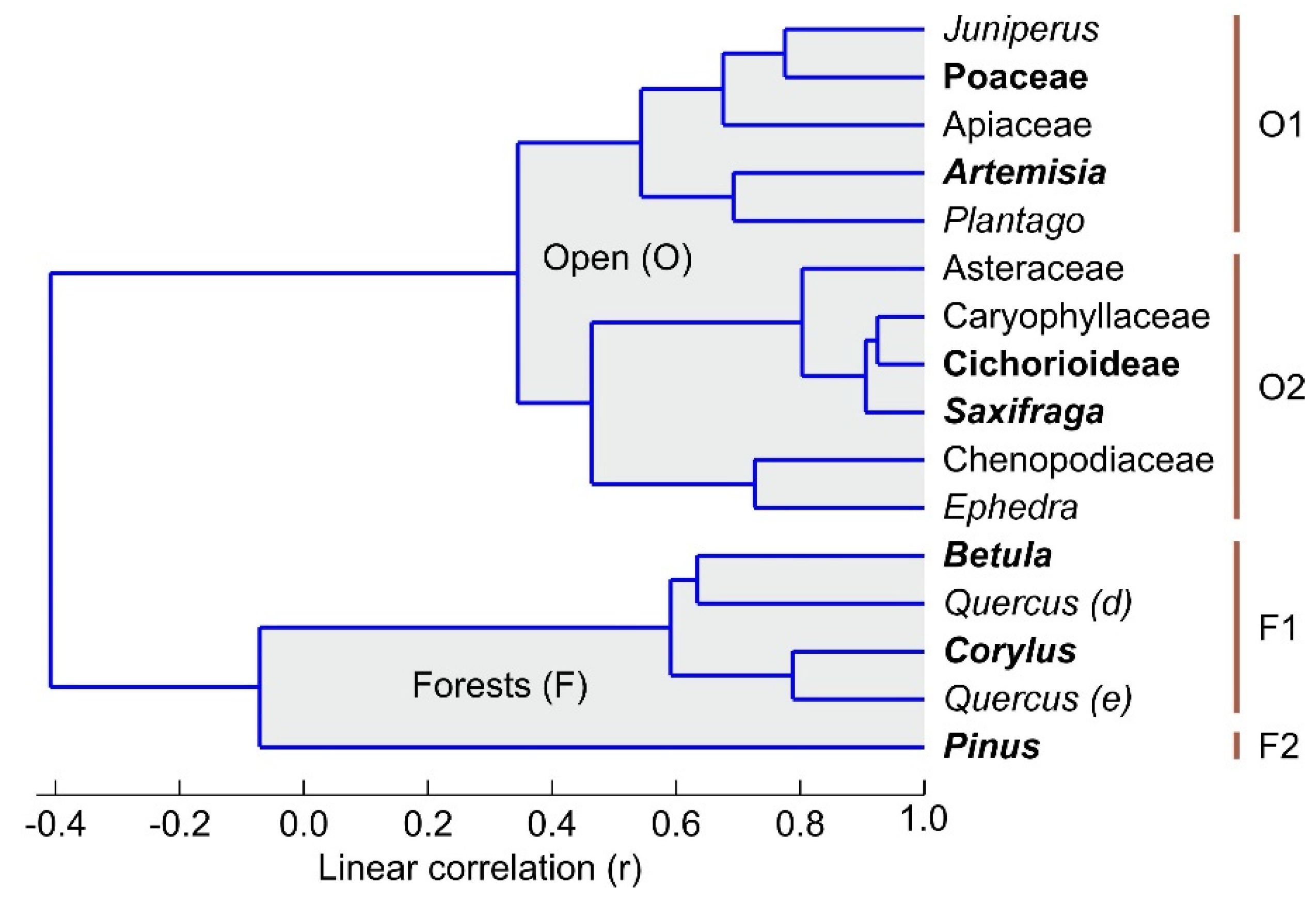
5.1. Vegetation Types
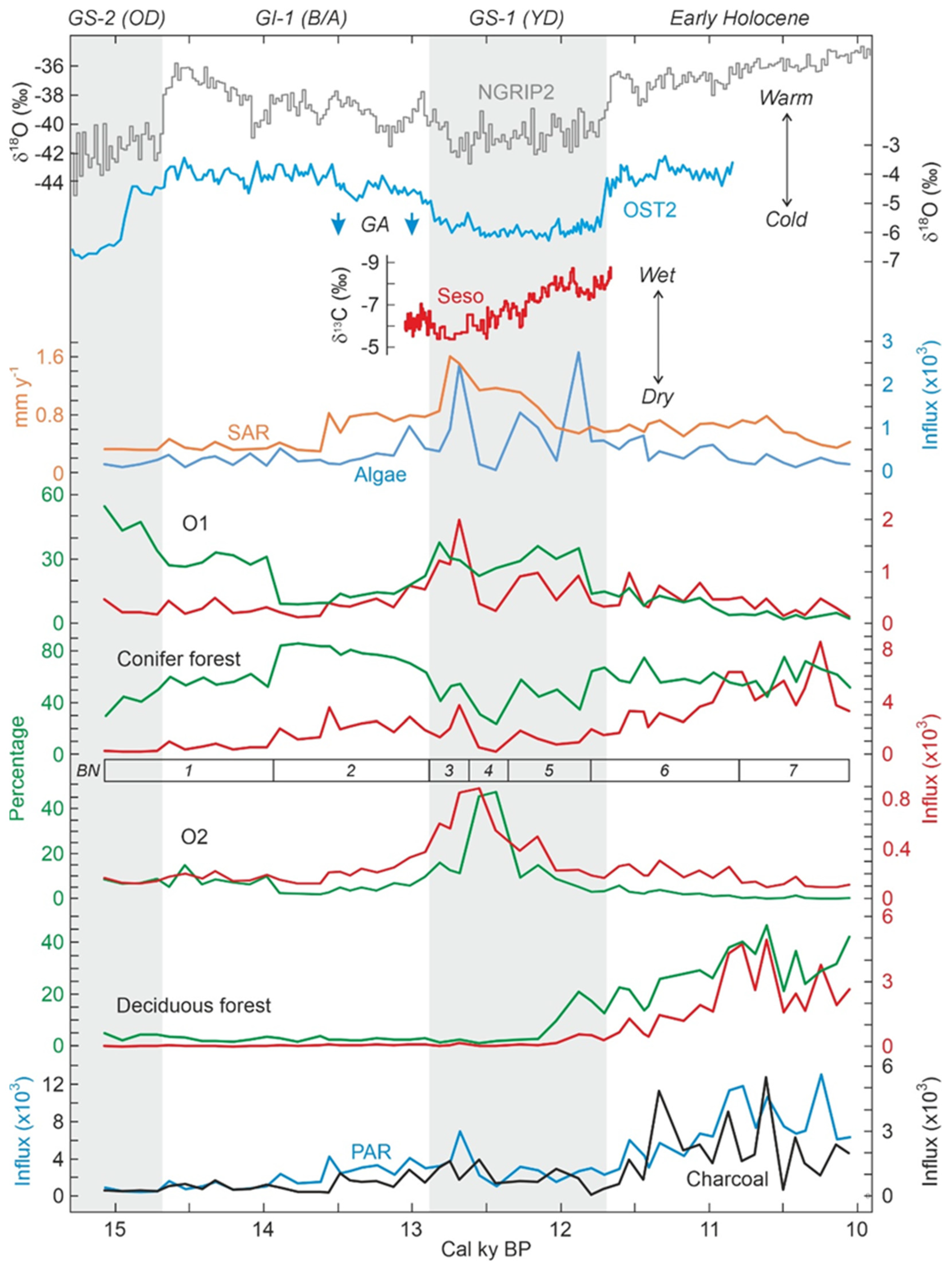
5.2. Climate Changes, Vegetation Shifts and Fire
5.2.1. GS-2 (Oldest Dryas)
5.2.2. GI-1 (Bølling/Allerød)
5.2.3. GS-1 (Younger Dryas)
5.2.4. Early Holocene
5.2.5. Fire Incidence
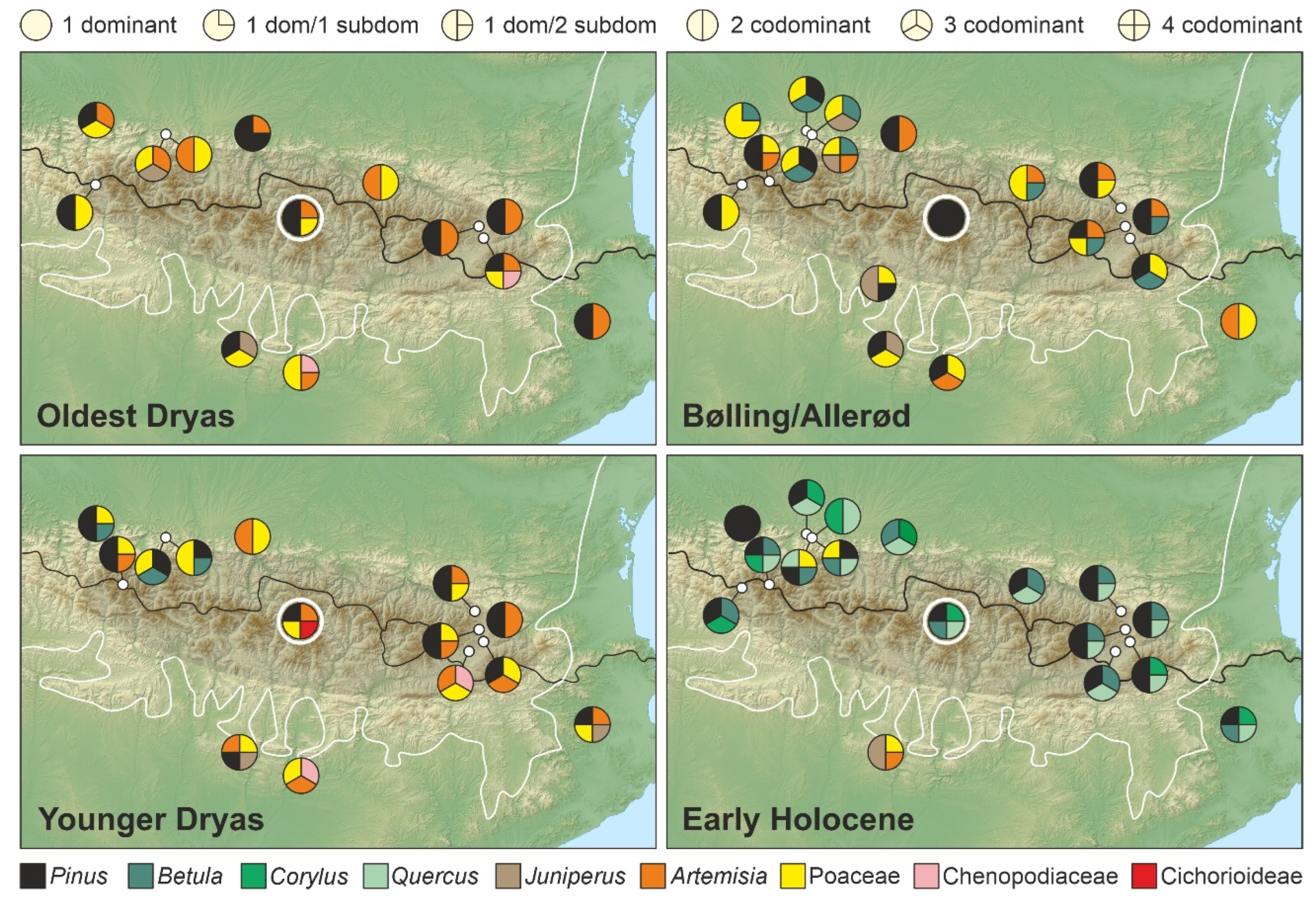
6. Regional Comparisons
6.1. Oldest Dryas
6.2. Bølling/Allerød
6.3. Younger Dryas
6.4. Early Holocene
7. Final Remarks and Future Prospects
Author Contributions
Funding
Data Availability Statement
Acknowledgments
Conflicts of Interest
Appendix A

| Site | Latitude N | Longitude | Elevation | Oldest Dryas | Bølling/Allerød | Younger Dryas | Early Holocene | Fire | References |
|---|---|---|---|---|---|---|---|---|---|
| Marboré | 42°41′44″ | 2°00′30″ E | 2612 | NR | Pinus Corylus | Pinus Corylus | Pinus Corylus | - | [66] |
| Gourg-Nègre | 42°38″ | 02°13″ E | 2080 | Pinus Artemisia | Pinus Artemisia Betula | Artemisia Pinus | Pinus Betula Quercus | - | [11] |
| Racou | 42°33′15″ | 0°02′24″ E | 2000 | NR | NR | Artemisia Chenopodiaceae Poaceae | Pinus Betula Quercus | - | [67] |
| Bassettes * | 42°39′30″ | 02°01″ E | 1900 | NR | Pinus Poaceae | NR | Pinus Corylus | - | [11] |
| Bassa Nera | 42°38′17″ | 0°55′27″ E | 1890 | Pinus Artemisia Poaceae | Pinus | Pinus Artemisia Poaceae Cichorioideae | Pinus Betula Corylus Quercus | - | This paper |
| Laurenti | 42°40′30″ | 02°01′46″ E | 1860 | NR | Pinus Artemisia Poaceae | Pinus Artemisia Poaceae | Pinus Betula Quercus | - | [11] |
| Portalet | 42°48″ | 00°23″ W | 1802 | Pinus Poaceae Artemisia Juniperus | Pinus Poaceae Artemisia Juniperus | NR | Pinus Betula Corylus | + | [16,20] |
| Balcère | 42°35′27″ | 02°03′18″ E | 1764 | Pinus Artemisia | Pinus Artemisia Poaceae Betula | Pinus Poaceae Artemisia | Pinus Betula Quercus | - | [11] |
| Pouretère | 42°48′40″ | 00°12′12″ W | 1720 | NR | Pinus Poaceae Artemisia | Pinus Poaceae Artemisia | Pinus Betula Quercus Corylus | - | [13] |
| Sagnes * | 42°35′27″ | 02°03′18″ E | 1670 | NR | Pinus Poaceae | NR | Pinus Betula | - | [11] |
| Tramacastilla ** | 42°43′27″ | 00°22′07″ W | 1668 | Pinus Poaceae Artemisia | Pinus Poaceae Artemisia | Pinus Poaceae Artemisia | Pinus Betula Quercus | - | [15] |
| Borde | 42°32″ | 02°05″ E | 1660 | Artemisia Pinus Poaceae Chenopodiaceae | Pinus Poaceae Betula | Pinus Poaceae Artemisia | Pinus Corylus Quercus | - | [11] |
| Bious | 42°50′ | 00°27′W | 1550 | ND | ND | ND | ND | [68] | |
| Freychinède | 42°48″ | 01°26′11″ E | 1350 | Artemisia Poaceae Pinus | Poaceae Artemisia Betula | NR | Pinus Betula Quercus | - | [69] |
| Búbal ** | 42°40′58″ | 00°19′13″ W | 1115 | Pinus Betula Juniperus | Pinus Betula Juniperus | Pinus Betula Juniperus Artemisia Poaceae | Pinus Betula Corylus | - | [15] |
| Bentué | 42°20′11″ | 00°29′23″ W | 1000 | NR | Juniperus Poaceae Pinus | NR | NR | - | [18] |
| Ech | 43°02″ | 00°05″ W | 710 | Poaceae Juniperus Artemisia | Poaceae Pinus Betula | Poaceae Pinus Betula | Quercus Poaceae Pinus Betula | + | [14] |
| Estanya | 42°02″ | 00°32″ E | 670 | Pinus Juniperus Poaceae | Pinus Juniperus Poaceae | Steppe elem. Poaceae Pinus Juniperus | Juniperus Poaceae Artemisia Pinus | - | [4] |
| Castet | 43°02′ | 00°22′W | 490 | ND | ND | ND | ND | - | [68] |
| Barbazan | 43°02′02″ | 00°37′28″ E | 480 | Pinus Artemisisa | Pinus Artemisisa | Artemisia Poaceae | Betula Corylus Quercus | - | [70] |
| Lourdes | 43°02″ | 00°05″ W | 430 | Artemisia Poaceae | Poaceae Betula Juniperus | NR | Quercus Corylus | - | [12] |
| Parco | 41°54′48″ | 00°56′31″ E | 420 | Poaceae Chenopodiaceae Asteraceae | Poaceae Asteraceae Pinus | Poaceae Chenopodiaceae Asteraceae | NR | - | [71] |
| Biscaye | 43°02″ | 00°04′15″ E | 410 | Artemisia Poaceae | Poaceae Betula Juniperus Artemisia | Poaceae Pinus Betula | Poaceae Pinus Betula Quercus | - | [12] |
| Monge | 43°03″ | 00°01′55″ E | 394 | NR | Poaceae Pinus Betula | Poaceae Pinus Betula | Quercus Corylus Pinus | - | [12] |
| Estarrès | 43°05′36″ | 00°22′45″ W | 356 | Pinus Artemisia Poaceae | Poaceae Betula | Pinus Poaceae Betula | Pinus Poaceae | - | [10] |
| Banyoles | 42°08′07″ | 02°45′23″ E | 175 | Pinus Artemisia | Artemisia Poaceae | Pinus Artemisia Poaceae Betula Juniperus | Pinus Betula Corylus Quercus | - | [56] |
References
- Carrión, J.S.; Fernández, S.; González-Sampériz, P.; Gil-Romera, G.; Badal, E.; Carrión-Marco, Y.; López-Merino, L.; López-Sáez, J.A.; Fierro, E.; Burjachs, F. Expected Trends and Surprises in the Lateglacial and Holocene Vegetation History of the Iberian Peninsula and Balearic Islands. Rev. Palaeobot. Palynol. 2020, 162, 458–475. [Google Scholar] [CrossRef]
- Rull, V.; Vegas-Vilarrúbia, T.; Corella, J.P.; Valero-Garcés, B. Bronze Age to Medieval vegetation dynamics and landscape anthropization in the southern-central Pyrenees. Palaeogeogr. Palaeoclimatol. Palaeoecol. 2021, 571, 110392. [Google Scholar] [CrossRef]
- Rull, V.; Vegas-Vilarrúbia, T.; Corella, J.P.; Trapote, M.C.; Montoya, E.; Valero-Garcés, B. A unique Pyrenean varved record provides a detailed reconstruction of Mediterranean vegetation and land-use dynamics over the last three millennia. Quat. Sci. Rev. 2021, 268, 107128. [Google Scholar] [CrossRef]
- González-Sampériz, P.; Aranbarri, J.; Pérez-Sanz, A.; Gil-Romera, G.; Moreno, A.; Leunda, M.; Sevilla-Callejo, M.; Corella, J.P.; Morellón, M.; Oliva, B.; et al. Environmental and Climate Change in the Southern Central Pyrenees Since the Last Glacial Maximum: A View from the Lake Records. Catena 2017, 149, 668–688. [Google Scholar] [CrossRef]
- Rull, V.; Vegas-Vilarrúbia, T. A spatiotemporal gradient in the anthropization of Pyerenan landscapes. Preliminary report. Quat. Sci. Rev. 2021, 258, 106909. [Google Scholar] [CrossRef]
- Rasmussen, S.O.; Bigler, M.; Blockley, S.P.; Blunier, T.; Buchardt, S.L.; Clausen, H.B.; Cvijanovic, I.; Dahl-Jensen, D.; Johnsen, S.J.; Fischer, H.; et al. A stratigraphic framework for abrupt climatic changes during the Last Glacial period based on three synchronized Greenland ice-core records: Refining and extending the INTIMATE event stratigraphy. Quat. Sci. Rev. 2014, 106, 14–28. [Google Scholar] [CrossRef]
- Bernal-Wormull, J.; Moreno, A.; Pérez-Mejías, C.; Bartolomé, M.; Aranburu, A.; Arriolabengoa, M.; Iriarte, E.; Cacho, I.; Spötl, C.; Edwards, R.; et al. Immediate temperature response in northern Iberia to last deglacial changes in the North Atlantic. Geology 2021, 49, 999–1003. [Google Scholar] [CrossRef]
- Bartolomé, M.; Moreno, A.; Sancho, C.; Stoll, H.M.; Cacho, I.; Spötl, C.; Belmonte, Á.; Edwards, R.L.; Cheng, H.; Hellstrom, J.C. Hydrological changes in southern Europe responding to increasing North Atlantic overturning during Greenland Stadial 1. Proc. Natl Acad. Sci. USA 2015, 112, 6568–6572. [Google Scholar] [CrossRef]
- Fernandes, M.; Oliva, M.; Vieira, G.; Palacios, D.; Fernández-Hernández, J.M.; Garcia-Oteyza, J.; Schimmelpfennig, I.; Team, A.; Antoniades, D. Glacial Oscillations during the Bølling-Allerød Interstadial-Younger Dryas Transition in the Ruda Valley, Central Pyrenees. J. Quat. Sci. 2022, 37, 42–58. [Google Scholar] [CrossRef]
- Jalut, G.; Montserrat Martí, J.; Fontugne, M.; Delibrias, G.; Vilaplana, J.M.; Julia, R. Glacial to interglacial vegetation changes in the northern and southern Pyrénées: Deglaciation, vegetation cover and chronology. Quat. Sci. Rev. 1992, 11, 449–480. [Google Scholar] [CrossRef]
- Reille, M.; Lowe, J.J. A Re-Evaluation of the Vegetation History of the Eastern Pyrenees (France) from the End of the Last Glacial to the Present. Quat. Sci. Rev. 1993, 12, 47–77. [Google Scholar] [CrossRef]
- Reille, M.; Andrieu, V. The late Pleistocene and Holocene in the Lourdes Basin, Western Pyrénées, France: New pollen analytical and chronological data. Veg. Hist. Archaeobot. 1995, 4, 1–21. [Google Scholar] [CrossRef]
- Aubert, S.; Belet, J.M.; Bouchette, A.; Otto, T.; Dedoubat, J.J.; Fontugne, M.; Jalut, G. Dynamique tardiglaciaire et holocène de la végétation à l’étage montagnard dans les Pyrénées centrales. Comptes Rendus Biol. 2004, 327, 381–388. [Google Scholar] [CrossRef] [PubMed]
- Rius, D.; Galop, D.; Doyen, E.; Millet, L.; Vannière, B. Biomass burning response to high-amplitude climate and vegetation changes in Southwestern France from the Last Glacial to the early Holocene. Veget. Hist. Archaeobot. 2014, 23, 729–742. [Google Scholar] [CrossRef]
- Montserrat Martí, J.M. Evolución Glaciar y Postglaciar del Clima y la Vegetación en la Vertiente sur del Pirineo: Estudio Palinológico; Monografías del Instituto Pirenaico de Ecología nº 6; Consejo Superior de Investigaciones Científicas: Zaragoza, Spain, 1992; pp. 1–147. [Google Scholar]
- González-Sampériz, P.; Valero-Garcés, B.; Moreno, A.; Jalut, G.; García-Ruiz, J.M.; Martí-Bono, C.; Delgado-Huertas, A.; Navas, A.; Otto, T.; Dedoubat, J.J. Climate variability in the Spanis Pyrenees during the last 30,000 yr revealed by the El Portalet sequence. Quat. Res. 2006, 66, 38–52. [Google Scholar] [CrossRef]
- García-Ruiz, J.M.; Palacios, D.; González-Sampériz, P.; de Andrés, N.; Moreno, A.; Valero-Garcés, B.; Gómez-Villar, A. Mountain glacier evolution in the Iberian Peninsula during the Younger Dryas. Quat. Sci. Rev. 2016, 138, 16–30. [Google Scholar] [CrossRef]
- González-Sampériz, P.; Valero-Garcés, B.; Carrión, J.S.; Peña-Monné, J.L.; García-Ruiz, J.M.; Martí-Bono, C. Glacial and lateglacial vegetation in northern Spain: New data and a review. Quat. Int. 2005, 140–141, 4–20. [Google Scholar] [CrossRef]
- González-Sampériz, P.; Leroy, S.A.; Carrión, J.S.; Fernández, S.; García-Antón, M.; Gil-García, M.J.; Uzquiano, P.; Valero-Garcés, B.; Figueiral, I. Steppes, savannahs, forests and phytodiversity reservoirs during the Pleistocene in the Iberian Peninsula. Rev. Palaeobot. Palynol. 2010, 162, 427–457. [Google Scholar] [CrossRef]
- Gil-Romera, G.; González-Sampériz, P.; Lasheras-Álvarez, L.; Sevilla-Callejo, M.; Moreno, A.; Valero-Garcés, B.; López-Merino, L.; Carrión, J.S.; Sanz, A.P.; Aranbarri, J.; et al. Biomass-modulated fire dynamics during the Last Glacial-Interglacial transition at the Central Pyrenees (Spain). Palaeogeogr. Palaeoclimatol. Palaeoecol. 2014, 402, 113–124. [Google Scholar] [CrossRef]
- Theuerkauf, M.; Couwenberg, J. ROPES reveals past land cover and PPs from single pollen records. Front. Earth Sci. 2018, 6, 14. [Google Scholar] [CrossRef]
- Cook, E.J.; van Geel, B.; van der Kaars, S.; van Arkel, J. A review of the use of non-pollen palynomorphs in palaeoecology with examples from Australia. Palynology 2011, 35, 155–178. [Google Scholar] [CrossRef]
- Shumilovskikh, L.S.; van Geel, B. Non-pollen palynomorphs. In Hanbook for the Analysis of Micro-Particles in Archaeological Samples; Henry, A.G., Ed.; Springer Nature: Cham, Switzerland, 2020; pp. 65–94. [Google Scholar]
- Garcés-Pastor, S.; Cañellas-Boltà, N.; Clavaguera, A.; Calero, M.A.; Vegas-Vilarrúbia, T. Vegetation shifts, human impact and peat bog development in Bassa Nera pond (Central Pyrenees) during the last millennium. Holocene 2016, 27, 553–565. [Google Scholar] [CrossRef]
- Garcés-Pastor, S.; Cañellas-Boltà, N.; Pèlachs, A.; Soriano, J.-M.; Pérez-Obiol, R.; Pérez-Haase, A.; Calero, M.-A.; Andreu, O.; Escolà, N.; Vegas-Vilarrúbia, T. Environmental history and vegetation dynamics in response to climate variations and human pressure during the Holocene in Bassa Nera, Central Pyrenees. Palaeogeogr. Palaeoclimatol. Palaeoecol. 2017, 479, 48–60. [Google Scholar] [CrossRef]
- López-Vila, J.; Montoya, E.; Cañellas-Boltà, N.; Rull, V. Modern non-pollen palynomorphs sedimentation along an elevational gradient in the south-central Pyrenees (southwestern Europe) as a tool for Holocene paleoecological reconstruction. Holocene 2014, 24, 327–345. [Google Scholar] [CrossRef]
- López-Vila, J.; Montoya, E.; Rull, V. Non-pollen palynomorphs analysis of the last two millennia in the Bassa Nera peat bog record (South-Central Pyrenees, SW Europe). In Proceedings of the VI Workshop Non-Pollen Palynomoprhs, Tallin, Estonia, 16–20 June 2014. [Google Scholar]
- Casas, J.M.; Álvaro, J.J.; Clausen, S.; Padel, M.; Puddu, C.; Sanz-López, J.; Sánchez-García, T.; Navidad, M.; Castiñeiras, P.; Liesa, M. Palaeozoic basement of the Pyrenees. In The Geology of Iberia: A Geodynamic Approach; Quesada, C., Oliveira, J.T., Eds.; Springer Nature: Cham, Switzerland, 2019; pp. 229–259. [Google Scholar]
- Delgado, J.; Soler, A. Ilvaite stability in skarns from the northern contact of the Maladeta batholith, Central Pyrenees (Spain). Eur. J. Mineral. 2010, 22, 363–380. [Google Scholar]
- López-Moreno, J.I.; Alonso-González, E.; Monserrat, O.; DEL Río, L.M.; Otero, J.; Lapazaran, J.; Luzi, G.; Dematteis, N.; Serreta, A.; Rico, I.; et al. Ground-based remote-sensing techniques for diagnosis of the current state and recent evolution of the Monte Perdido Glacier, Spanish Pyrenees. J. Glaciol. 2019, 65, 85–100. [Google Scholar] [CrossRef]
- Rivas-Martínez, S.; Penas, A.; del Río, S.; Díaz, T.E.; Rivas-Sáenz, S. Bioclimatology of the Iberian Peninsula and the Balearic Islands. In The Vegetation of the Iberian Peninsula; Loidi, J., Ed.; Springer Nature: Cham, Switzerland, 2017; pp. 29–80. [Google Scholar]
- Cañellas-Boltà, N.; Rull, V.; Vigo, J.; Mercadé, A. Modern pollen-vegetation relationships along an altitudinal transect in the central Pyerenees (southwestern Europe). Holocene 2009, 19, 1185–1200. [Google Scholar] [CrossRef]
- Pérez-Haase, A.; Ninot, J.M. Hydrological heterogeneity rather than water chemistry explains the high plant diversity and uniqueness of a Pyrenean mixed mire. Folia Geobot. 2017, 52, 143–160. [Google Scholar] [CrossRef]
- Gassiot Ballbè, E.; Mazzucco, N.; Clemente Conte, I.; Rodríguez Antón, D.; Obea Gómez, L.; Quesada Carrasco, M.; Díaz Bonilla, S. The beginning of high mountain occupations in the Pyrenees. Human settlements and mobility from 18,000 cal BC to 2000 cal BC. In High Mountain Conservation in a Changing World; Catalan, J., Ninot, J.M., Aniz, M., Eds.; Springer Nature: Cham, Switzerland, 2017; pp. 75–105. [Google Scholar]
- Vandergoes, M.J. AMS dating of pollen concentrates—A methodlological study of Late Quaternary sediments from South Westland, New Zealand. Radiocarbon 2003, 45, 479–491. [Google Scholar] [CrossRef]
- Reimer, P.J.; Austin, W.E.N.; Bard, E.; Bayliss, A.; Blackwell, P.G.; Ramsey, C.B.; Butzin, M.; Cheng, H.; Edwards, R.L.; Friedrich, M.; et al. The IntCal20 Northern Hemisphere radiocarbon age calibration curve (0–55 cal kBP). Radiocarbon 2020, 62, 725–757. [Google Scholar] [CrossRef]
- Blaauw, M.; Christen, J.A. Flexible paleoclimate age-depth models using an autoregressive gamma process. Bayesian Anal. 2011, 6, 457–474. [Google Scholar] [CrossRef]
- Bennett, K.D.; Willis, K.D. Pollen. In Tracking Environmental Change Using Lake Sediments. Volume 3: Terrestrial, Algal and Siliceous Indicators; Smol, J.P., Birks, H.J.B., Last, W.M., Eds.; Kluwer: New York, NY, USA, 2001; pp. 5–32. [Google Scholar]
- Stockmarr, J. Tablets with spores used in absolute pollen analysis. Pollen Spores 1971, 13, 615–621. [Google Scholar]
- Moore, P.D.; Webb, J.A.; Collinson, M.E. Pollen Analysis; Blackwell: Oxford, UK, 1991. [Google Scholar]
- Reille, M. Pollen et Spores d’Europe et d’Afrique du Nord; URA-CNRS: Marseille, France, 1992. [Google Scholar]
- Baker, A.G.; Bhagwat, S.A.; Willis, K.J. Do dung fungal spores make a good proxy for past distribution of large herbivores? Quat. Sci. Rev. 2013, 62, 21–31. [Google Scholar] [CrossRef]
- Cugny, C.; Mazier, F.; Galop, D. Modern and fossil non-pollen palynomorphs from the Basque mountains (western Pyrenees, France): The use of coprophilous fungi to reconstruct pastoral activity. Veget. Hist. Archaeobot. 2010, 19, 391–408. [Google Scholar] [CrossRef]
- Gauthier, E.; Jouffroy-Bapicot, I. Detecting human impacts: Non-pollen palynomorphs as proxies for human impact on the environment. In Applications of Non-Pollen Palynomorphs: From Palaeoenvironmental Reconstruction to Biostratigraphy; Marret, F., O’Keefe, J., Osterloff, P., Pound, M., Shumilovkikh, L., Eds.; Geological Society of London: London, UK, 2021; pp. 233–244. [Google Scholar]
- Lee, C.M.; van Geel, B.; Gosling, W.D. On the use of spores of coprohilous fungi preserved in sediments to indicate past herbivore presence. Quaternary 2022, 5, 30. [Google Scholar] [CrossRef]
- García Álvarez, S.; Morla Juaristi, C.; Solana Gutiérrez, J.; García-Amorena, I. Taxonomic differences between Pinus sylvestris and P. uncinata revealed in the stomata and cutilce characters for use in the study of fossil material. Rev. Palaeobot. Palynol. 2009, 155, 61–68. [Google Scholar] [CrossRef]
- Rull, V. A note on pollen counting in palaeoecology. Pollen Spores 1987, 29, 471–480. [Google Scholar]
- Perrin, C.; Honiat, C.; Prestimonaco, L. Deciphering paleohydrology from the petrography and microstratigraphy of stalagmites (MIS 5–Holocene, Moulis Cave, Ariège, S. France). Sediment. Geol. 2022, 440, 106256. [Google Scholar] [CrossRef]
- Whitlock, C.; Larsen, C. Charcoal as a fire proxy. In Tracking Environmental Change Using Lake Sediments. Volume 3: Terrestrial, Algal and Siliceous Indicators; Smol, J.P., Birks, H.J.B., Last, W.L., Eds.; Kluwer: New York, NY, USA, 2001; pp. 75–97. [Google Scholar]
- Bennett, K.D. Determination of the number of zones in a biostratigraphical sequence. New Phytol. 1996, 132, 155–170. [Google Scholar] [CrossRef]
- Sokal, R.R.; Michener, C.D. A statistical method for evaluating systematic relationships. Univ. Kansas Sci. Bull. 1958, 38, 1409–1438. [Google Scholar]
- Bennett, K.D. Psimpoll—A quickbasic program that generates postcript page description of pollen diagrams. INQUA Newsl. 1992, 8, 11–12. [Google Scholar]
- Kovack, W. MVSP—A Multivariate Statistical Package for Windows, version 3.1; Kovach Computing: Pentraeth, UK, 1999.
- Hammer, Ø.; Harper, D.A.T.; Ryan, P.D. Past: Paleontological statistics sofware package for education and data analysis. Palaeontol. Electr. 2001, 4, 4. [Google Scholar]
- Subally, D.; Quézel, P. Glacial or interglacial, a plant indicator with dual responses. Rev. Palaeobot. Palynol. 2002, 120, 123–130. [Google Scholar] [CrossRef]
- Mazier, F.; Galop, D.; Brun, C.; Buttler, A. Modern pollen assemblages from grazed vegetation in western Pyrenees, France: A numerical tool for more precise reconstruction of past cultural landscapes. Holocene 2006, 16, 91–103. [Google Scholar] [CrossRef]
- Pérez-Obiol, R.; Julià, R. Climatic change on the Iberian Peninsula recorded in a 30,000-yr pollen record from Lake Banyoles. Quat. Res. 1994, 41, 91–98. [Google Scholar] [CrossRef]
- van der Knaap, W.O.; van Leeuwen, J.F.N. Late Glacial and Early Holocene vegetation succession, altitudinal vegetation succession, and climatic change in the Serra da Estrela, Portugal. Rev. Palaeobot. Palynol. 1997, 97, 239–285. [Google Scholar] [CrossRef]
- Vigo, J. L’Alta Muntanya Catalana: Flora i Vegetació; Institut d’Estudis Catalans: Barcelona, Spain, 2009. [Google Scholar]
- Bertran, P.; Sitzia, L.; Banks, W.E.; Bateman, M.D.; Demars, P.-Y.; Hernandez, M.; Lenoir, M.; Mercier, N.; Prodeo, F. The Landes de Gascogne (southwest France): Periglacial desert and cultural frontier during the Paleolithic. J. Archaeol. Sci. 2013, 40, 2274–2285. [Google Scholar] [CrossRef]
- Ponel, P.; Parchoux, F.; Andrieu-Ponel, V.; Juhasz, V.; de Beaulieu, J.-L. A late-glacial—Holocene fossil insect succession from Vallée des Merveilles, French Alps, and its paleoecological implications. Arct. Antarct. Alpine Res. 2001, 33, 481–484. [Google Scholar] [CrossRef]
- Rull, V. Microrefugia. J. Biogeogr. 2009, 36, 481–484. [Google Scholar] [CrossRef]
- de Lafontaine, G.; Amasifuen, C.A.; Ducousso, A.; Petit, R.J. Cryptic no more: Soil macrofossils uncover Pleistocene forest microrefugia within a periglacial desert. New Phytol. 2014, 204, 715–729. [Google Scholar] [CrossRef]
- Carrión, J.S.; Ochando, J.; Munuera, M.; Casas-Gallego, M.; González-Sampériz, P.; López-Sáez, J.A.; Postigo-Mijarra, J.M.; Barrón, E.; Badal, E.; Carrión-Marco, Y.; et al. Paleoflora y Paleovegetación Ibérica II: Pleistoceno; Ministerio de Ciencia e Innovación/Fundación Séneca: Murcia, Spain, 2022. [Google Scholar]
- Rull, V.; Burjachs, F.; Carrión, J.S.; Ejarque, A.; Fernández, S.; López-Sáez, J.A.; Luelmo-Lautenschlaeger, R.; Ochando, J.; Pérez-Díaz, S.; Revelles, J.; et al. Historical biogeography of Cannabis in the Iberian Peninsula: A probabilistic aproach based on palynological evidence. Persp. Plant Ecol. Evol. Syst. 2003, 58, 125704. [Google Scholar] [CrossRef]
- Leunda, M.; González-Sampériz, P.; Gil-Romera, G.; Aranbarri, J.; Moreno, A.; Oliva-Urcia, B.; Sevilla-Callejo, M.; Valero-Garcés, B. The Late-Glacial and Holocene Marboré Lake sequence (2612 m a.s.l., Central Pyrenees, Spain): Testing high-altitude sites sensitivity to millennial scale vegetation and climate variability. Glob. Planet. Chang. 2017, 157, 214–231. [Google Scholar] [CrossRef]
- Guiter, F.; Andrieu-Ponel, V.; Digerfeldt, G.; Reille, M.; de Beaulieu, J.L.; Ponel, P. Vegetation history and lake-level changes from the Younger Dryas to the present in Eastern Pyrenees (France): Pollen, plant macrofossils and lithostratigraphy from Lake Racou (2000 m a.s.l.). Veget. Hist. Archaeobot. 2005, 14, 99–118. [Google Scholar] [CrossRef]
- Jalut, G.; Andrieu, V.; Delibrias, G.; Fortugne, M.; Pagès, P. Palaeoenvironment of the valley of Ossau (western french Pyrénées) during the last 27000 years. Pollen Spores 1988, 30, 357–394. [Google Scholar]
- Jalut, G.; Delibrias, G.; Dagnac, J.; Mardonès, M.; Bouhours, M. A palaeoecological approach to the last 21,000 years in the Pyrénées: The peat bog of Freychinède (alt. 1350 m, Ariège, South France). Palaeogeogr. Palaeoclimatol. Palaeoecol. 1982, 40, 321–359. [Google Scholar] [CrossRef]
- Jalut, G.; Turu, V. Le dernier cycle glaciaire-interglaciaire dans les Pyrenees: Englacement, climat, vegetation. In Pyrenees d’Hier et d’Aujourd’hui; Canérot, J., Coli, J.-P., Platel, J.-P., Bilotte, M., Eds.; Altantica: Biarritz, France, 2008; pp. 145–161. [Google Scholar]
- Bergadà, M.; Burjachs, F.; Fullola, J.M. Évolution paléoenvironnemental du 14.500 au 10.000 BP dans le Prépyrénées catalans: La Grotte du Parco (Alòs de Balaguer, Lleida, Espagne). L’Anthropologie 1999, 103, 249–264. [Google Scholar]


| Lab Code | Drive | Sample | Depth (cm) | 14C yr BP | Cal yr BP (2σ) |
|---|---|---|---|---|---|
| ULA-10114 | D7 | 63–64 | 802 | 9260 ± 20 | 10,300–10,557 |
| ULA-10115 | D7 | 104–105 | 854 | 9785 ± 20 | 11,191–11,241 |
| ULA-10116 | D8 | 19–20 | 874 | 10,040 ± 20 | 11,358–11,727 |
| ULA-10117 | D8 | 51–52 | 913 | 10,410 ± 20 | 12,102–12,482 |
| ULA-10118 | D8 | 94–95 | 964 | 10,635 ± 20 | 12,621–12,716 |
| ULA-10119 | D9 | 32–33 | 990 | 10,915 ± 20 | 12,757–12,882 |
| ULA-10120 | D9 | 76–77 | 1047 | 11,710 ± 25 | 13,493–13,602 |
| ULA-10121 | D9 | 119–120 | 1103 | 12,715 ± 25 | 15,049–15,281 |
| Charcoal | p (uncorr) | |
|---|---|---|
| PAR | 0.6249 | 9.5 × 10⁻⁷ |
| Conifer forest | 0.4845 | 0.0003 |
| Deciduous forest | 0.6999 | 1.1 × 10⁻⁸ |
| O1 | 0.1453 | 0.3088 |
| O2 | 0.0162 | 0.9103 |
Disclaimer/Publisher’s Note: The statements, opinions and data contained in all publications are solely those of the individual author(s) and contributor(s) and not of MDPI and/or the editor(s). MDPI and/or the editor(s) disclaim responsibility for any injury to people or property resulting from any ideas, methods, instructions or products referred to in the content. |
© 2023 by the authors. Licensee MDPI, Basel, Switzerland. This article is an open access article distributed under the terms and conditions of the Creative Commons Attribution (CC BY) license (https://creativecommons.org/licenses/by/4.0/).
Share and Cite
Rull, V.; Blasco, A.; Calero, M.Á.; Blaauw, M.; Vegas-Vilarrúbia, T. A Continuous Centennial Late Glacial-Early Holocene (15–10 cal kyr BP) Palynological Record from the Iberian Pyrenees and Regional Comparisons. Plants 2023, 12, 3644. https://doi.org/10.3390/plants12203644
Rull V, Blasco A, Calero MÁ, Blaauw M, Vegas-Vilarrúbia T. A Continuous Centennial Late Glacial-Early Holocene (15–10 cal kyr BP) Palynological Record from the Iberian Pyrenees and Regional Comparisons. Plants. 2023; 12(20):3644. https://doi.org/10.3390/plants12203644
Chicago/Turabian StyleRull, Valentí, Arnau Blasco, Miguel Ángel Calero, Maarten Blaauw, and Teresa Vegas-Vilarrúbia. 2023. "A Continuous Centennial Late Glacial-Early Holocene (15–10 cal kyr BP) Palynological Record from the Iberian Pyrenees and Regional Comparisons" Plants 12, no. 20: 3644. https://doi.org/10.3390/plants12203644