
Changes in the Invasion Rate of Prosopis juliflora and Its Impact on Depletion of Groundwater in the Northern Part of the United Arab Emirates

 , , ,
, , ,  , , ,
, , ,  and
and
Abstract
:1. Introduction
2. Materials and Methods
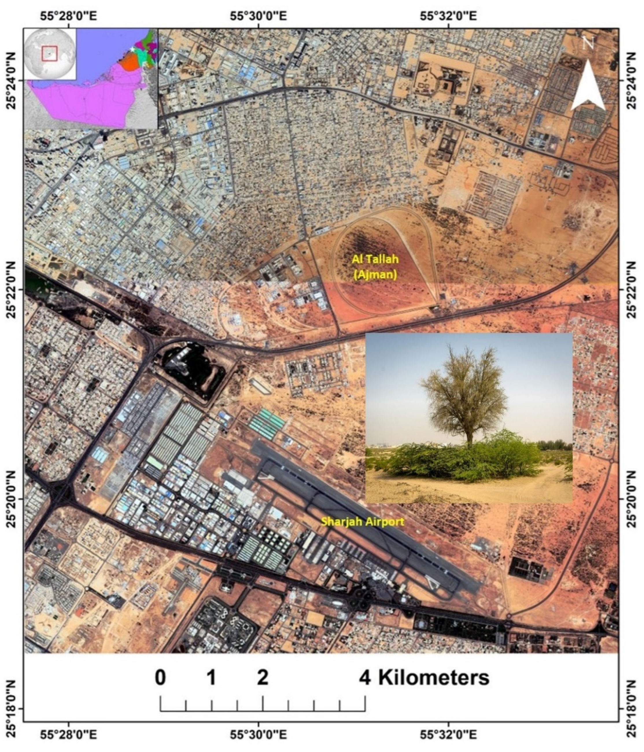
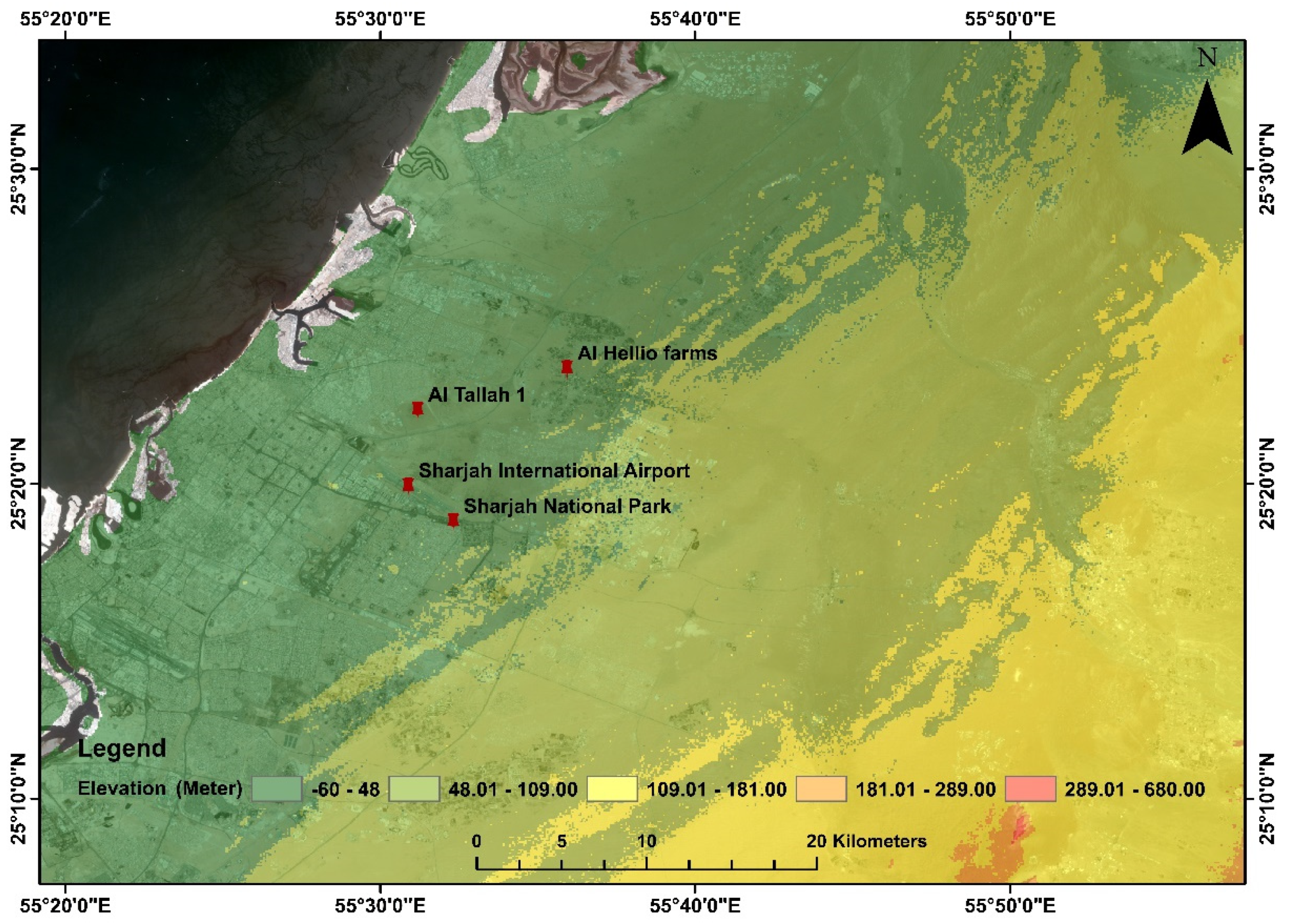
2.1. Study Area
2.2. Data Collection
2.3. Data Analysis
2.4. Estimation of Evapotranspiration and P. juliflora Groundwater Requirement
3. Results and Discussion
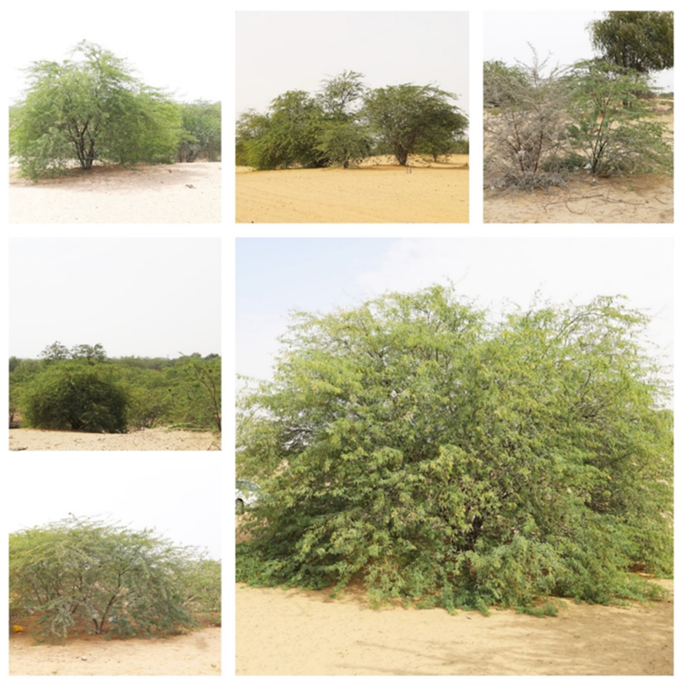
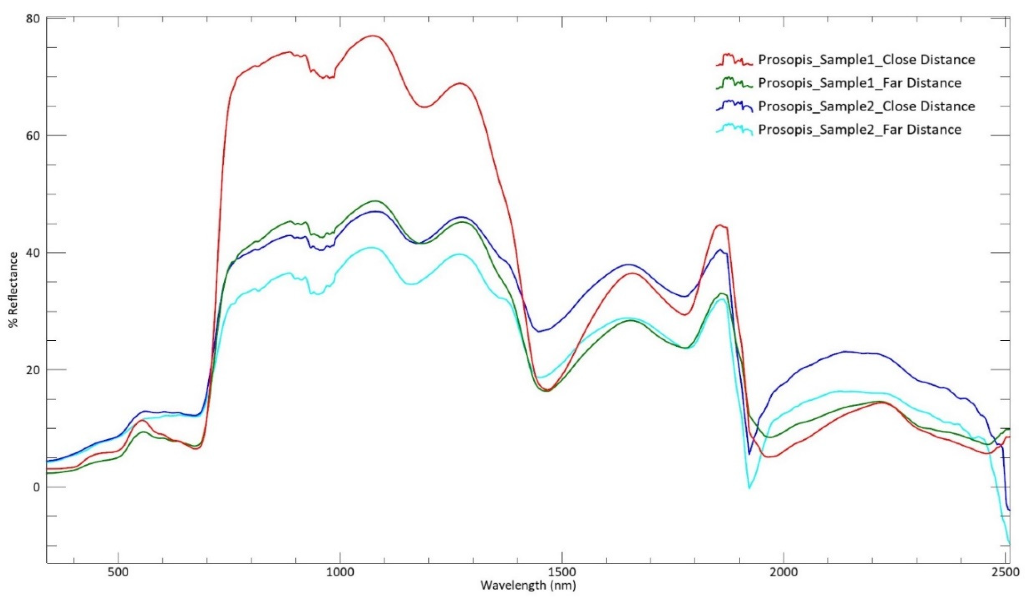
3.1. Field Data: Identification of Mesquite (P. juliflora) Based on Reflectance
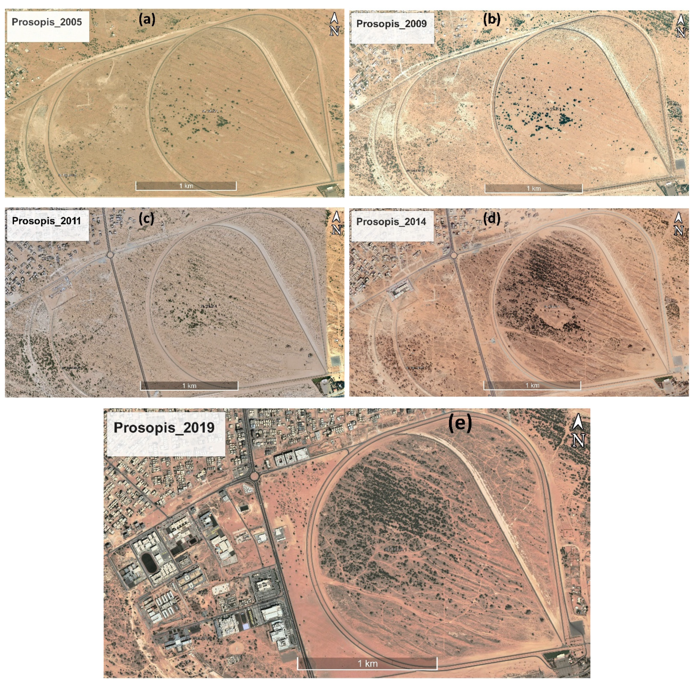
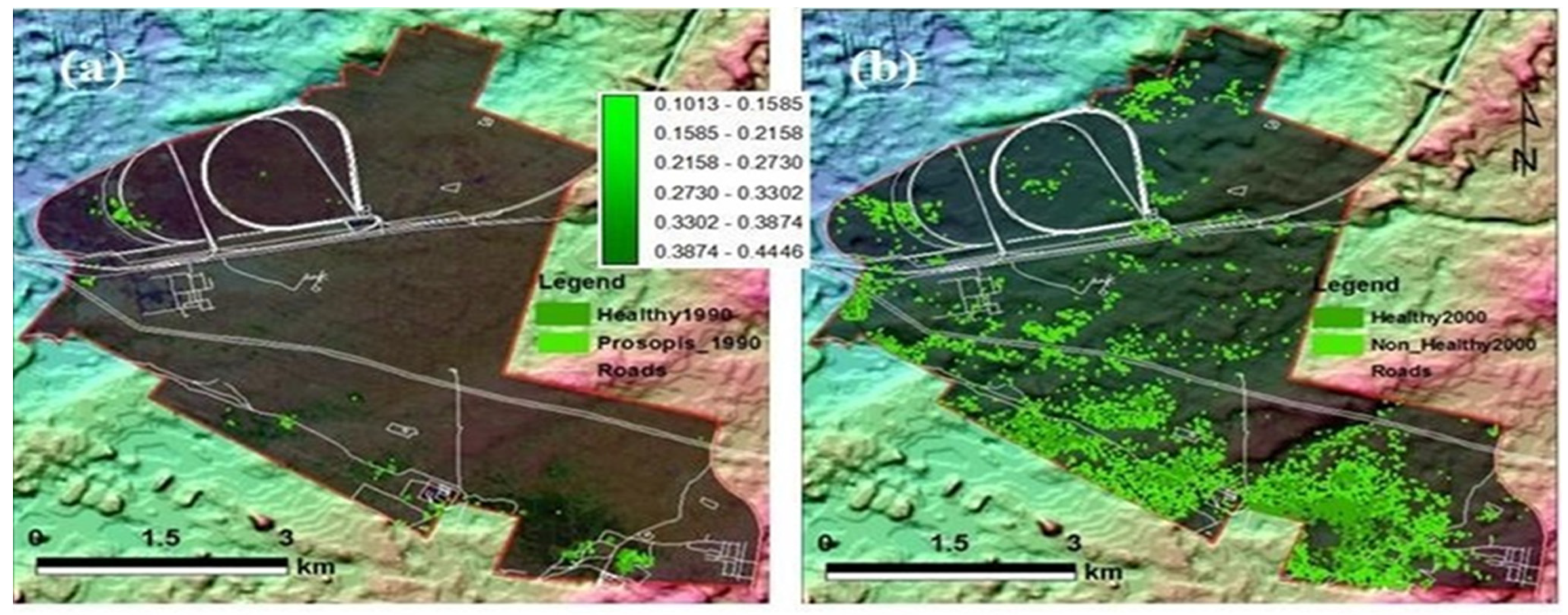
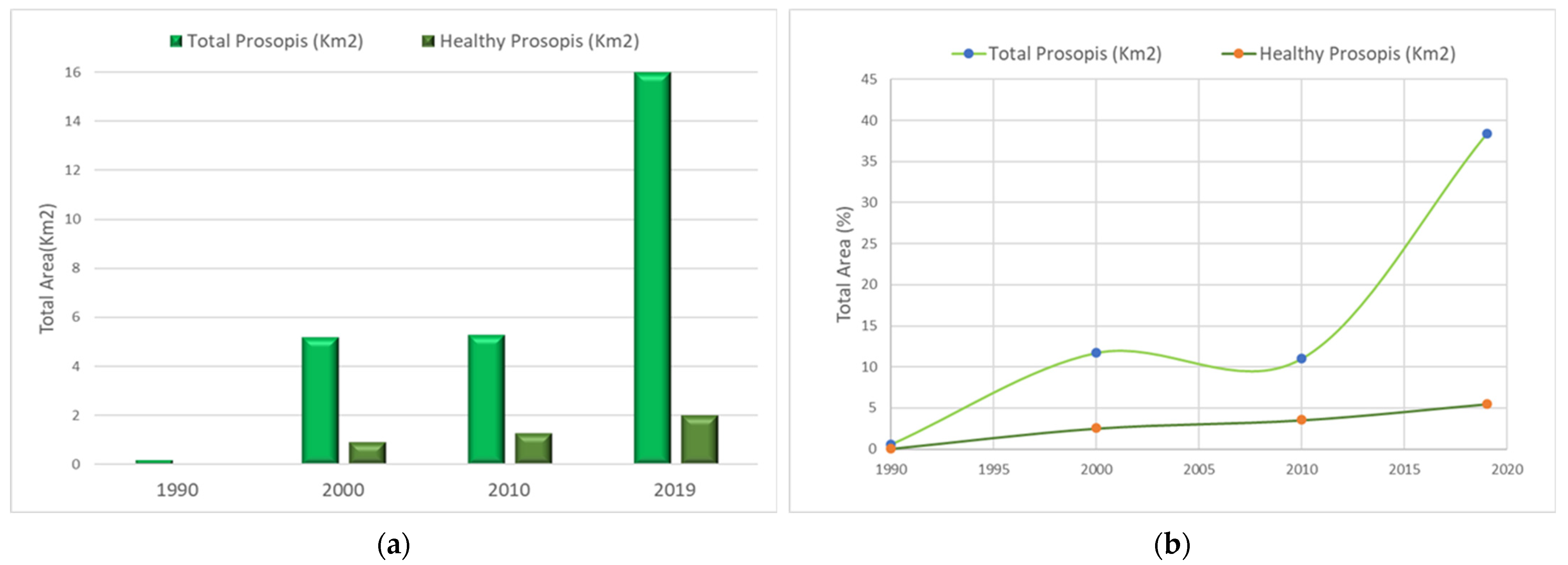
3.2. Monitoring Prosopis Change
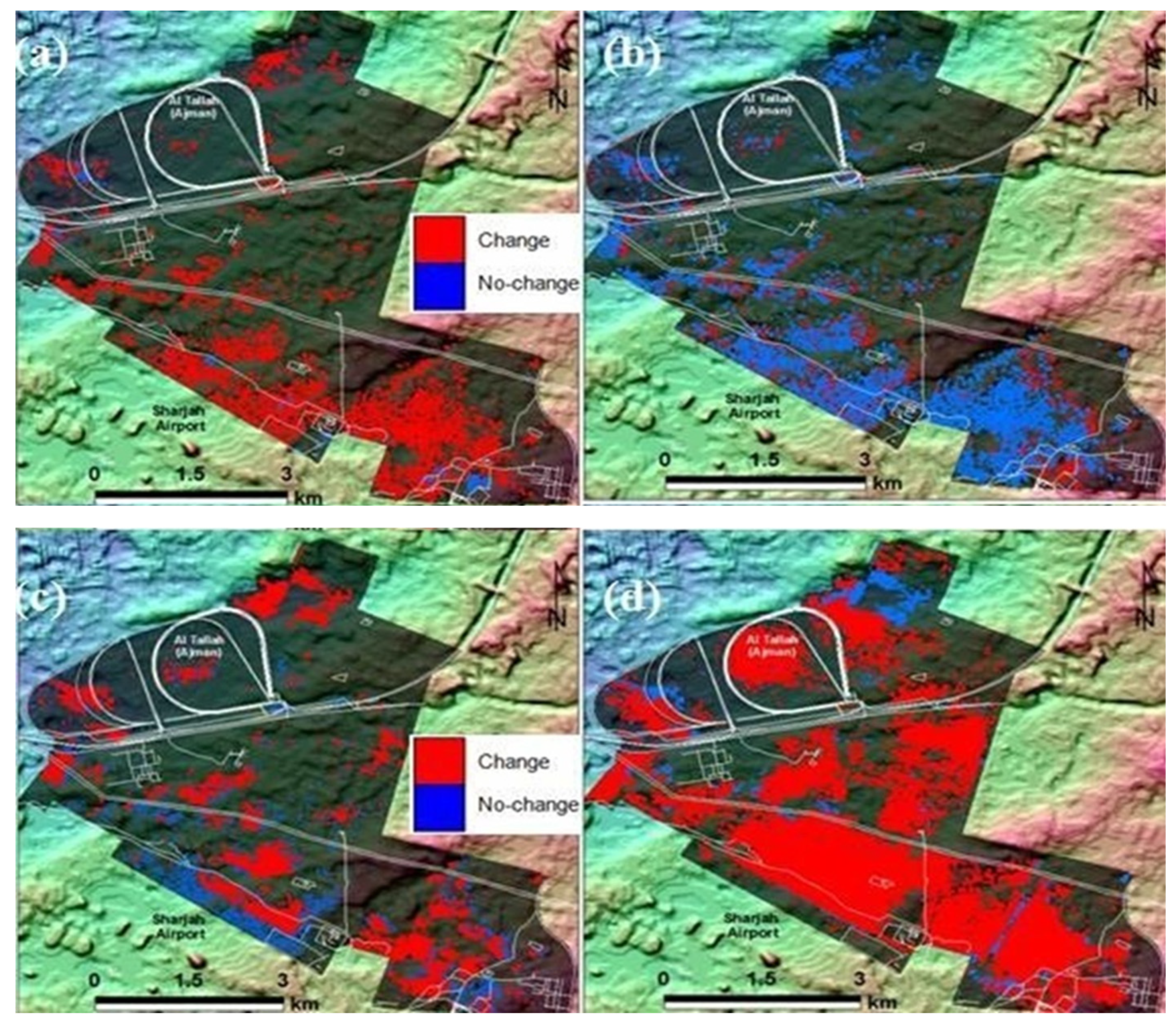
3.3. Prosopis Change Detection
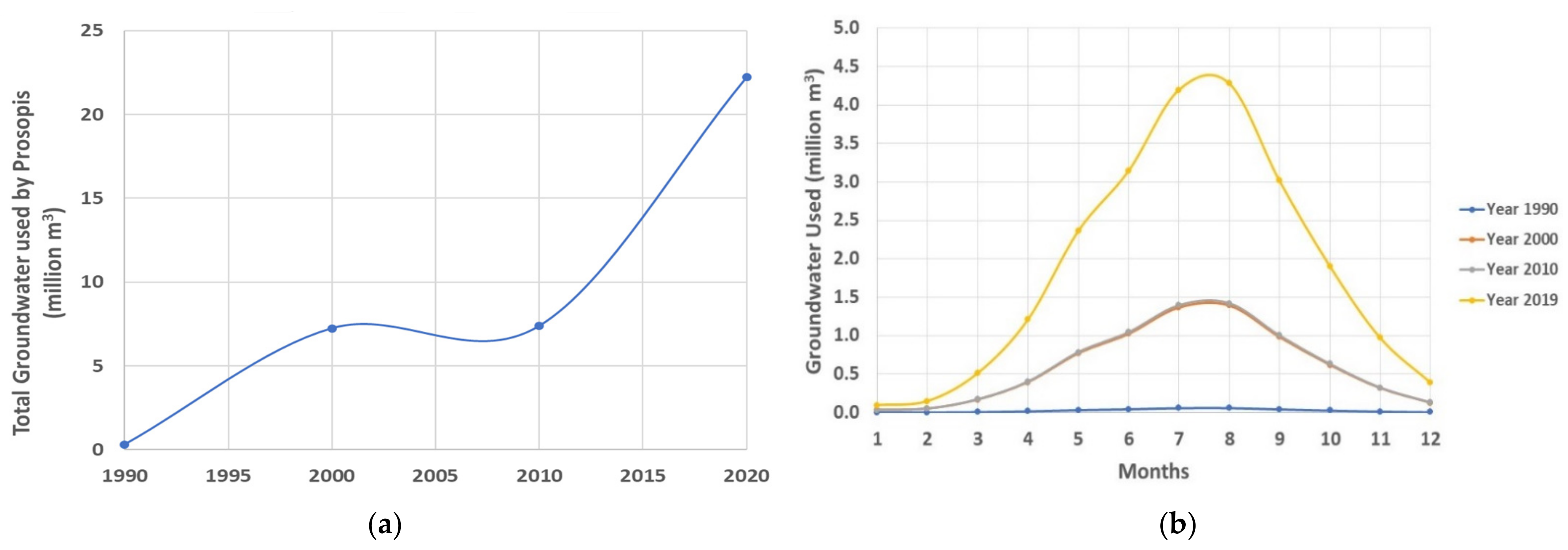
3.4. Evapotranspiration and P. juliflora Water
4. Conclusions
Author Contributions
Funding
Institutional Review Board Statement
Informed Consent Statement
Data Availability Statement
Acknowledgments
Conflicts of Interest
References
- Wehbe, Y.; Temimi, M. A remote sensing-based assessment of water resources in the Arabian Peninsula. Remote Sens. 2021, 13, 247. [Google Scholar] [CrossRef]
- Scott, R.L.; Cable, W.L.; Hultine, K.R. The ecohydrologic significance of hydraulic redistribution in a semiarid savanna. Water Resour. Res. 2008, 44, 1–12. [Google Scholar] [CrossRef]
- Shackleton, R.T.; Le Maitre, D.C.; Pasiecznik, N.M.; Richardson, D.M. Prosopis: A global assessment of the biogeography, benefits, impacts and management of one of the world’s worst woody invasive plant taxa. AoBP 2014, 6, plu027. [Google Scholar] [CrossRef]
- Richardson, D.M.; Hui, C.; Nuñez, M.A.; Pauchard, A. Tree invasions: Patterns, processes, challenges, and opportunities. Biol. Invasions 2014, 16, 473–481. [Google Scholar] [CrossRef]
- Moodley, D.; Geerts, S.; Richardson, D.M.; Wilson, J.R.U. Different Traits Determine Introduction, Naturalization and Invasion Success in Woody Plants: Proteaceae as a Test Case. PLoS ONE 2013, 8, e75078. [Google Scholar] [CrossRef] [PubMed] [Green Version]
- Whitford, W.G.; Duval, B.D. Nonnative, Exotic, or Alien Species. In Ecology of Desert Systems, 2nd ed.; Whitford, W., Duval, B., Eds.; Elsevier: Amsterdam, The Netherlands, 2019; pp. 317–342. [Google Scholar]
- Ogbazghi, W. The Mesquite tree (Prosopis juliflora and Prosopis chilenis): Alien invasive plant species-Blessing in disguise or nuisance to Eritrean Ecosystems? In Proceedings of the International Conference of Eritrean Studies, Asmara Palace Hotel, Asmara, Eritrea, 20–22 July 2016. [Google Scholar]
- El-Keblawy, A.; Al-Rawai, A. Effects of salinity, temperature and light on germination of invasive Prosopis juliflora (Sw.) DC. J. Arid Environ. 2005, 61, 555–565. [Google Scholar] [CrossRef]
- El-Keblawy, A.; Al-Rawai, A. Effects of seed maturation time and dry storage on light and temperature requirements during germination in invasive Prosopis juliflora. Flora-Morphol. Distrib. Funct. Ecol. Plants 2006, 201, 135–143. [Google Scholar] [CrossRef]
- Richardson, D.M.; Pysek, P.; Rejmanek, M.; Barbour, M.G.; Panetta, F.D.; West, C.J. Naturalization and invasion of alien plants: Concepts and definitions. Divers. Distrib. 2000, 6, 93–107. [Google Scholar] [CrossRef]
- Shaik, V.P.; Satish, K.V.; Sudhakar Reddy, C.; Jha, C.S. Massive Invasion of Mesquite (Prosopis juliflora) in Wild Ass Wildlife Sanctuary, India. Natl. Acad. Sci. Lett. 2015, 38, 271–273. [Google Scholar]
- Hussain, M.I.; El-Keblawy, A.; Mitterand, T.F. Leaf age, canopy position, and habitat affect the carbon isotope discrimination and water-use efficiency in three C3 leguminous Prosopis species from a hyper-arid climate. Plants 2019, 8, 402. [Google Scholar] [CrossRef] [Green Version]
- Hussain, M.I.; Shackleton, R.; El-Keblawy, A.; González, L.; Trigo, M. Impact of the Invasive Prosopis juliflora on Terrestrial Ecosystems. Sustain. Agric. Rev. 2021, 52, 223–278. [Google Scholar]
- Tsombou, F.M.; El-Keblawy, A.; Elsheikh, E.A.; AbuQamar, S.F.; El-Tarabily, K.A. Allelopathic effects of native and exotic Prosopis congeners in Petri dishes and potting soils: Assessment of the congeneric approach. Botany 2022. [Google Scholar] [CrossRef]
- Dzikiti, S.; Ntshidi, Z.; Le Maitre, D.C.; Bugan, R.D.; Mazvimavi, D.; Schachtschneider, K.; Pienaar, H.H. Assessing water use by Prosopis invasions and Vachellia karroo trees: Implications for groundwater recovery following alien plant removal in an arid catchment in South Africa. For. Ecol. Manag. 2017, 398, 153–163. [Google Scholar] [CrossRef]
- Dalle Fratte, M.; Bolpagni, R.; Brusa, G.; Caccianiga, M.; Pierce, S.; Zanzottera, M.; Cerabolini, B.E. Alien plant species invade by occupying similar functional spaces to native species. Flora 2019, 257, 151419. [Google Scholar] [CrossRef]
- Van Kleunen, M.; Dawson, W.; Schlaepfer, D.; Jeschke, J.M.; Fischer, M. Are invaders different? A conceptual framework of comparative approaches for assessing determinants of invasiveness. Ecol. Lett. 2010, 13, 947–958. [Google Scholar] [CrossRef]
- Dakhil, M.A.; El-Keblawy, A.; El-Sheikh, M.A.; Halmy, M.W.A.; Ksiksi, T.; Hassan, W.A. Global invasion risk assessment of Prosopis juliflora at biome level: Does soil matter? Biology 2021, 10, 203. [Google Scholar] [CrossRef]
- Elfadl, M.; Luukkanen, O. Field studies on the ecological strategies of Prosopis juliflora in a dryland ecosystem: 1. A leaf gas exchange approach. J. Arid Environ. 2006, 66, 1–15. [Google Scholar] [CrossRef]
- Mwangi, E.; Swallow, B. Invasion of Prosopis Juliflora and Local Livelihoods: Case Study from the Lake Baringo Area of Kenya. Nairobi Kenya World Agrofor. Cent. 2005. [Google Scholar] [CrossRef]
- Mishra, A.; Sharma, S.D.; Gupta, M.K. Soil Rehabilitation through Afforestation: Evaluation of the Performance of Prosopis juliflora, Dalbergia sissoo and Eucalyptus tereticornis Plantations in a Sodic Environment. Arid Land Res. Manag. 2003, 17, 257–269. [Google Scholar] [CrossRef]
- Sharma, R.; Dakshini, K.M.M. Integration of plant and soil characteristics and the ecological success of two shape Prosopis species. Plant Ecol. 1998, 139, 63–69. [Google Scholar] [CrossRef]
- Tenge, A.J.; Degraaff, J.; Hella, J.P. Financial efficiency of major soil and water conservation measures in west Usambara highlands, Tanzania. Appl. Geogr. 2005, 25, 348–366. [Google Scholar] [CrossRef]
- Choge, S.K.; Clement, N.; Gitonga, M.; Okuye, J. Status report on commercialization of Prosopis tree resources in Kenya. In Technical Report for the KEFRI/KFS Technical Forest Management and Research Liaison Committee; KEFRI: Nairobi, Kenya, 2012. [Google Scholar]
- Brown, L.S.; Boudjelas, S.; De Poorter, M. 100 of the World’s Worst Invasive Alien Species: A Selection from the Global Invasive Species Database; The Invasive Species Specialist Group (ISSG), Species Survival Commission (SSC) of the World Conservation Union (IUCN): Auckland, New Zealand, 2004. [Google Scholar]
- Tanner, R.; Branquart, E.; Brundu, G.; Buholzer, S.; Chapman, D.; Ehret, P.; van Valkenburg, J. The prioritisation of a short list of alien plants for risk analysis within the framework of the Regulation (EU) No. 1143/2014. NeoBiota 2017, 35, 87–118. [Google Scholar] [CrossRef]
- El-Keblawy, A.; Al-Rawai, A. Impacts of the invasive exotic Prosopis juliflora (Sw.) D.C. on the native flora and soils of the UAE. Plant Ecol. 2007, 190, 23–35. [Google Scholar] [CrossRef]
- Kneuper, C.L.; Scott, C.B.; Pinchak, W.E. Consumption and dispersion of Mesquite seeds by ruminants. J. Range Manag. 2003, 56, 255–259. [Google Scholar] [CrossRef]
- Wronski, T.; Plath, M. Characterisation of the spatial distribution of latrines in reintroduced mountain gazelles (Gazella gazella): Do latrines demarcate female group home ranges? J. Zool. 2009, 280, 92–101. [Google Scholar] [CrossRef]
- Abbas, A.M.; Soliman, W.S.; El Taher, A.M.; Hassan, I.N.; Mahmoud, M.; Youssif, M.F.; Mansour, M.H.; Abdelkareem, M. Predicting the spatial spread of invasive Prosopis juliflora (SW.) D.C along environmental gradients in Gabel Elba National Park, Egypt. Int. J. Eng. Res. 2016, 7, 596–599. [Google Scholar]
- Alvarez, M.; Leparmarai, P.; Heller, G.; Becker, M. Recovery and germination of Prosopis juliflora (Sw.) DC seeds after ingestion by goats and cattle. Arid Land Res. Manag. 2017, 31, 71–80. [Google Scholar] [CrossRef]
- El-Keblawy, A.; Abdelfateh, M.A. Impacts of native and invasive exotic Prosopis congeners on soil properties and associated flora in the arid United Arab Emirates. J. Arid Environ. 2014, 1, 100–101. [Google Scholar] [CrossRef]
- Böer, B. An introduction to the climate of the United Arab Emirates. J. Arid Environ. 1997, 35, 3–16. [Google Scholar] [CrossRef]
- Murad, A.; Krishnamurthy, R. Factors controlling groundwater quality in eastern United Arab Emirates: A chemical and isotope approach. J. Hydrol. 2003, 286, 227–235. [Google Scholar] [CrossRef]
- Issa, S.M.; Dohai, B. GIS Analysis of Invasive Prosopis juliflora Dynamics in Two selected Sites from the United Arab Emirates (UAE). Can. J. Appl. Sci. 2008, 2, 235–242. [Google Scholar]
- Garrido, M.; Silva, P.; Acevedo, E. Water Relations and Foliar Isotopic Composition of Prosopis tamarugo Phil., an Endemic Tree of the Atacama Desert Growing at Three Levels of Water Table Depth. Front. Plant Sci. 2016, 7, 375. [Google Scholar] [CrossRef] [PubMed] [Green Version]
- Shiferaw, H.; Alamirew, T.; Dzikiti, S.; Bewket, W.; Zeleke, G.; Schaffner, U. Water use of Prosopis juliflora and its impacts on catchment water budget and rural livelihoods in Afar Region, Ethiopia. Sci. Rep. 2021, 11, 2688. [Google Scholar] [CrossRef] [PubMed]
- Dzikiti, S.; Bugan, R.; Maitre, D.L.; Ntshidi, Z.; Ramoelo, A.; Gush, M.; Schachtschneider, K. Comparison of water use by Prosopis spp. and the cooccurring vachellia karroo trees before and after clearing the invasions: Implications on groundwater. Water Res. Comm. Rep. 2018, 2256, 8. [Google Scholar]
- Dzikiti, S.; Schachtschneider, K.; Naiken, V.; Gush, M.; Moses, G.; Le Maitre, D.C. Water relations and the effects of clearing invasive Prosopis trees on groundwater in an arid environment in the Northern Cape, South Africa. J. Arid Environ. 2013, 90, 103–113. [Google Scholar] [CrossRef]
- Al Yamani, W.; Green, S.; Pangilinan, R.; Dixon, S.; Shahid, S.A.; Kemp, P.; Clothier, B. Water use of Al Ghaf (Prosopis cineraria) and Al Sidr (Ziziphus spina-christi) forests irrigated with saline groundwater in the hyper-arid deserts of Abu Dhabi. Agr. Wat. Manag. 2018, 203, 105–114. [Google Scholar] [CrossRef]
- Howari, F.M.; Sharma, M.; Xavier, C.M.; Nazzal, Y.; Salem, I.B.; Al Aydaroos, F. Remote sensing and GIS based approaches to estimate evapotranspiration in the arid and semi-arid regions. In Remote Sensing for Agriculture, Ecosystems, and Hydrology XXIII; SPIE: Madrid, Spain, 2021; Volume 11856, pp. 85–92. [Google Scholar]
- Feulner, G.R. Rainfall and climate records from Sharjah Airport: Historical data for the study of recent climatic periodicity in the UAE. Tribulus 2006, 16, 3–9. [Google Scholar]
- Slate, M.L.; Tsombou, F.M.; Callaway, R.M.; El-Keblawy, A.A. Exotic Prosopis juliflora suppresses understory diversity and promotes agricultural weeds more than a native congener. Plant Ecol. 2020, 221, 659–669. [Google Scholar] [CrossRef]
- El-Keblawy, A.; Ksiksi, T. Artificial forests as conservation sites for the native flora of the UAE. For. Ecol. Manag. 2005, 213, 288–296. [Google Scholar] [CrossRef]
- Howari, F.M.; Ghrefat, H.; Nazzal, Y.; Galmed, M.A.; Abdelghany, O.; Fowler, A.R.; Sharma, M.; AlAydaroos, F.; Xavier, C.M. Delineation of Copper Mineralization Zones at Wadi Ham, Northern Oman Mountains, United Arab Emirates Using Multispectral Landsat 8 (OLI) Data. Front. Earth Sci. 2020, 8, 578075. [Google Scholar] [CrossRef]
- Hunt, R.; Hamilton, R.; Everitt, J. Mapping Weed Infestations Using Remote Sensing; Remote Sensing Applications Center, USDA Forest Service: Salt Lake City, UT, USA, 2005. [Google Scholar]
- Lemenkova, P. Processing remote sensing data using Erdas Imagine for mapping Aegean Sea region, Turkey. In Proceedings of the 15th International Conference on Informatics. Problems, Methodology, Technologies; Voronezh State University: Voronezh, Russia, 2015; pp. 11–15. [Google Scholar]
- Eliason, E.M.; McEwen, A.S. Adaptive box filters for removal of random noise from digital images. Photogramm. Eng. Remote Sens. 1990, 56, 453–458. [Google Scholar]
- Elmahdy, S.I.; Mohamed, M.M. Monitoring and analysing the Emirate of Dubai’s land use/land cover changes: An integrated, low-cost remote sensing approach. Int. J. Digit. Earth 2018, 11, 1132–1150. [Google Scholar] [CrossRef]
- Howari, F.M.; Murad, A.; Garamoon, H. Prediction of spatial ET-fluxes using remote sensing and field data of selected areas in the Eastern Part of Abu Dhabi, United Arab Emirates. Soil Res. 2006, 44, 759–768. [Google Scholar] [CrossRef]
- Hennings, V. Use of pedotransfer function for land evaluation: Mapping groundwater recharge rates under semi-arid conditions. In Noval Measurement and Assessment Tools for Monitoring and Management of Land and Water Resources in Agriculture Landscapes in Central Asia; Springer: Berlin/Heidelberg, Germany, 2014. [Google Scholar]
- Howari, F.; Murad, A. Estimation of Evapotranspiration of Green Landscapes in AL Ain, United Arab using Normalized vegetation index and Ground surface meteorological data. In Proceedings of the 2005 Salt Lake City Annual Meeting, Salt Lake, UT, USA, 16–19 October 2005. [Google Scholar]
- Thornthwaite, C.W. An approach towards a rational classification of climate. Geogr. Rev. 1948, 38, 55–94. [Google Scholar]
- El-Keblawy, A.; Abdelfattah, M.A.; Khedr, A.H.A. Relationships between landforms, soil characteristics and dominant xerophytes in the hyper-arid northern United Arab Emirates. J. Arid Environ. 2015, 117, 28–36. [Google Scholar] [CrossRef]
- UAE-NCMS, Cloud Seeding Research: Studies and Assessment, United Arab Emirates National Center of Meteorology Seismology (SCMS). 2016. Available online: http://www.ncms.ae/en/ncms-bookdetails.html?id=03 (accessed on 21 February 2020).


| Parameter | January | February | March | April | May | June | July | August | September | October | November | December |
|---|---|---|---|---|---|---|---|---|---|---|---|---|
| Avg. Temp (°C) | 18 | 18.9 | 21.5 | 24.4 | 28.2 | 30.6 | 33 | 33.5 | 31.2 | 27.7 | 23.8 | 20.1 |
| Prec. (in) | 0.7 | 0.7 | 0.7 | 0.2 | 0 | 0 | 0.1 | 0 | 0 | 0 | 0.1 | 0.4 |
| Year | 1990 | 2000 | 2010 | 2019 | |||||||
|---|---|---|---|---|---|---|---|---|---|---|---|
| Parameters | km2 | % | km2 | % | % Increase | km2 | % | % Increase | km2 | % | % Increase |
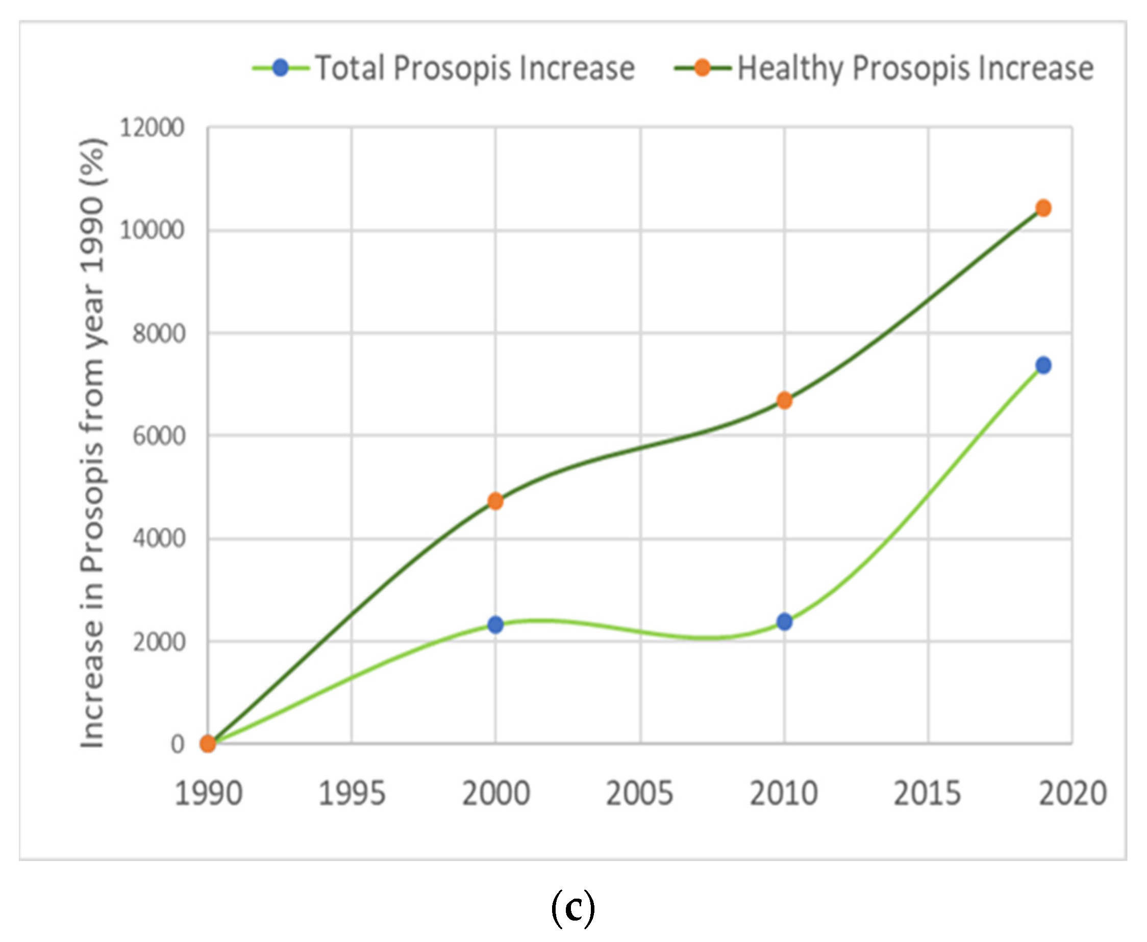
| Prosopis | 0.195 | 0.53 | 4.29 | 11.7 | 2100 | 4.02 | 11.0 | 1961 | 13.99 | 38.36 | 7075 |
| Healthy Prosopis | 0.019 | 0.052 | 0.92 | 2.53 | 4742 | 1.29 | 3.54 | 6689 | 2.00 | 5.49 | 10,426 |
| Prosopis Total Area | 0.214 km2 | 5.21 km2 | 2334% | 5.31 km2 | 2381% | 15.99 km2 | 7371% | ||||
| Month | ETo mm/month | ETcrop mm/month | ETcrop inch/month | Precipitation (inch) | Evapo_Groundwater |
|---|---|---|---|---|---|
| January | 30.77 | 23.69 | 0.932 | 0.7 | 0.232 |
| February | 35.12 | 27.04 | 1.064 | 0.7 | 0.364 |
| March | 64.76 | 49.86 | 1.963 | 0.7 | 1.263 |
| April | 105.28 | 81.06 | 3.191 | 0.2 | 2.991 |
| May | 192.70 | 148.37 | 5.841 | 0.0 | 5.841 |
| June | 256.60 | 197.58 | 7.779 | 0.0 | 7.779 |
| July | 345.97 | 266.40 | 10.488 | 0.1 | 10.388 |
| August | 349.68 | 269.25 | 10.600 | 0.0 | 10.600 |
| September | 246.28 | 189.64 | 7.466 | 0.0 | 7.466 |
| October | 155.50 | 119.73 | 4.714 | 0.0 | 4.714 |
| November | 82.60 | 63.60 | 2.504 | 0.1 | 2.404 |
| December | 44.85 | 34.54 | 1.359 | 0.4 | 0.959 |
| Annually | 1910.16 | 1470.82 | 57.906 | 2.9 | 55.006 |
| Month | 1990 | 2000 | 2010 | 2019 |
|---|---|---|---|---|
| January | 0.0013 | 0.0306 | 0.0312 | 0.0940 |
| February | 0.0020 | 0.0480 | 0.0489 | 0.1473 |
| March | 0.0068 | 0.1663 | 0.1695 | 0.5103 |
| April | 0.0162 | 0.3937 | 0.4013 | 1.2084 |
| May | 0.0316 | 0.7689 | 0.7836 | 2.3597 |
| June | 0.0421 | 1.0239 | 1.0435 | 3.1423 |
| July | 0.0562 | 1.3673 | 1.3935 | 4.1963 |
| August | 0.0573 | 1.3952 | 1.4220 | 4.2821 |
| September | 0.0404 | 0.9827 | 1.0015 | 3.0159 |
| October | 0.0255 | 0.6205 | 0.6324 | 1.9043 |
| November | 0.0130 | 0.3164 | 0.3225 | 0.9712 |
| December | 0.0052 | 0.1263 | 0.1288 | 0.3877 |
| Annually | 0.2974 | 7.2398 | 7.3787 | 22.2197 |
Publisher’s Note: MDPI stays neutral with regard to jurisdictional claims in published maps and institutional affiliations. |
© 2022 by the authors. Licensee MDPI, Basel, Switzerland. This article is an open access article distributed under the terms and conditions of the Creative Commons Attribution (CC BY) license (https://creativecommons.org/licenses/by/4.0/).
Share and Cite
Howari, F.M.; Sharma, M.; Nazzal, Y.; El-Keblawy, A.; Mir, S.; Xavier, C.M.; Salem, I.B.; Al-Taani, A.A.; Alaydaroos, F. Changes in the Invasion Rate of Prosopis juliflora and Its Impact on Depletion of Groundwater in the Northern Part of the United Arab Emirates. Plants 2022, 11, 682. https://doi.org/10.3390/plants11050682
Howari FM, Sharma M, Nazzal Y, El-Keblawy A, Mir S, Xavier CM, Salem IB, Al-Taani AA, Alaydaroos F. Changes in the Invasion Rate of Prosopis juliflora and Its Impact on Depletion of Groundwater in the Northern Part of the United Arab Emirates. Plants. 2022; 11(5):682. https://doi.org/10.3390/plants11050682
Chicago/Turabian StyleHowari, Fares M., Manish Sharma, Yousef Nazzal, Ali El-Keblawy, Shajrat Mir, Cijo M. Xavier, Imen Ben Salem, Ahmed A. Al-Taani, and Fatima Alaydaroos. 2022. "Changes in the Invasion Rate of Prosopis juliflora and Its Impact on Depletion of Groundwater in the Northern Part of the United Arab Emirates" Plants 11, no. 5: 682. https://doi.org/10.3390/plants11050682