Review

Communication Technologies in Emergency Situations

1
La Salle Campus Barcelona—Research Group in Internet Technologies and Storage, Universitat Ramon Llull, 08022 Barcelona, Spain
2
Saico-Intelligence. SL, 08034 Barcelona, Spain
*
Author to whom correspondence should be addressed.
Electronics 2022, 11(7), 1155; https://doi.org/10.3390/electronics11071155
Submission received: 25 February 2022 / Revised: 1 April 2022 / Accepted: 2 April 2022 / Published: 6 April 2022
(This article belongs to the Special Issue Ubiquitous Sensor Networks)

Abstract

:
Emergency situations such as wildfires, water floods, or even terrorist attacks require continuous communication between the coordination centres, the several on-the-field teams, and their respective devices to properly address the adverse circumstances. From a technological point of view, this can be best seen as a live Ubiquitous Sensor Network—composed of human beings (e.g., first responders, victims) and devices (e.g., drones, environmental sensors, radios)—with stringent and special communication requirements in terms of flexibility, mobility, reliability, bandwidth, heterogeneity, and speed of deployment. However, for this specific use case, most of the already deployed and well-known communication technologies (e.g., satellite, 4G/5G) might become unusable and hard to repair due to the associated effects of the disaster itself. The purpose of this paper is (1) to review the emergency communications challenges, (2) to analyse the existing surveys on technologies for emergency situations, (3) to conduct a more updated, extensive, and systematic review of the emergency communications’ technologies, and (4) to propose a heterogeneous communication architecture able to communicate between moving agents in harsh conditions. The proposed approach is conceived to link the relocating agents that constitute a Ubiquitous Sensor Network spanning a large-scale area (i.e., hundreds of square kilometres) by combining Near Vertical Incidence Skywave technologies with Drone-Based Wireless Mesh Networks. The conclusions derived from this research aim to set up the fundamentals of a rapidly deployable Emergency Communications System inspired by the Ubiquitous Sensor Network paradigm.

1. Introduction

Ensuring high-quality and reliable communications during an emergency is critical for responding to the emergency in the most viable way, saving lives and property through effectively coordinating first responders (FRs) with the remaining stakeholders in the operational, informational, and evaluative teams. Emergencies place demands on communication processes that are unique and very stringent. Emergencies often involve escalating and evolving events that demand high performance and flexibility from the emergency communication systems, such as message prioritization, automation of communication, fast message delivery, communication audit trails, security, interoperability, and other capabilities. Inadequate emergency communications capabilities can have consequences that are inconvenient at best and disastrous at worst [1].
Depending on the location, time, and nature of the emergency, a large variety of challenges could present themselves in an emergency. For example, an audio public warning system might be rendered ineffective if the emergency happens to be an explosive event which renders most or all of those affected deaf. Another example could be the overloading or failure of public services (such as cellular phone networks), resulting in an excessive delay of messages being transmitted through the network. Natural disasters such as earthquakes, wildfires, and flash floods can damage the communications infrastructure, hindering the rescue operations. In spite of the fact that telecommunications companies own Emergency Communications Vehicles that can partially restore the communications in less than 30 min, this solution relies on expensive technologies (i.e., satellite) and may be too time consuming for disasters that occur in difficult-access areas. In addition, terrorist attacks might damage existing infrastructure and have disastrous effects on the population. To intimidate governments or society, to induce insecurity for political, religious, or ideological purposes, terrorism is currently a threat with a significant effect on the safety of the population.
To effectively fight these emergency situations and mitigate their associated negative consequences, FRs together with all the interdisciplinary emergency services (administrations, radio amateurs, and general public) involved in the scene need as much in-field information as possible to forecast their strategy and operations. That is, they need a huge amount of time-critical data coming from multiple sources and services, even external ones such as social networks. This requires the rapid deployment of an Emergency Communication Systems (ECSs) aimed to link a set of personnel and apparatuses that must cooperate in extreme/hazardous situations with quick response times and under stress conditions. This reliable communications system must collect, transmit, process, and receive data required to continuously monitor and assess the disaster evolution.
The context of this research work is, thus, the future Emergency Communications Systems, with a particular focus on the required integration of technologies in such a dynamic and demanding scenario. Indeed, this shares several similarities with a Ubiquitous Sensor Network (USN), where a dynamic set of heterogeneous sensors and actuators (e.g., FRs, citizens, devices) with different capabilities are deployed and, spanning a large-scale area, must cooperate.
Several ECS solutions integrating innovative technologies such as Unmanned Aerial Vehicles (UAVs) [2] and Internet of Things (IoT) [3] have been deployed in the last years, but, usually, they are completely tailored to very concrete scenarios. Indeed, the more novel technologies are integrated within an ECS, and as more research works arise for specific application scenarios, the need of a standardized architecture to guarantee the interoperability and reusability of all these specific novel solutions and technologies is clearer.
In this line, this paper first introduces the ECSs and their requirements in Section 2. Second, Section 3 includes desk research, collecting and analysing all the existing surveys/reviews on the topic and identifying the ECS requirements addressed in each of them, and third, an updated and extensive systematic review on ECS technologies is presented in Section 4, collecting the latest research works in the field and including an analysis of the proposed technologies. The paper concludes with a discussion chapter (Section 5) proposing an architecture for ECS based on the USN Architecture from the International Telecommunications Union (ITU) as a solution to the detected open issues, and details how it would be applied in an emergency scenario combining IoT, UAVs, Near Vertical Incidence Skywave (NVIS), and Edge Computing.

2. Emergency Communications Systems

In general, the identification of an emergency is announced by reporting an emergency situation addressed to the Center of Integrated Rescue System (CIRS) [4]. Components of the Integrated Rescue System include firefighters, police forces, ambulances, rescue services, mountain rescue services, marine rescue services, and mine rescue services. The announcement of the emergence can be reported, e.g., in the form of an emergency call (switched links, mobile communication systems, etc.), oral information from residents, information from police forces, by automatically sending information from sensors designed to detect emergencies, etc. Based on the nature of the emergency event and the required form of support for its solution, CIRS will contact the corresponding first responders. Depending on the character of the emergency event, residents of the affected area can also be informed about the emergency by alerting, warning, and notification systems of the state. Based on the received announcement, CIRS will send the corresponding IRS teams to the place of emergency, which will be referred to as first responders. The technological support in the field of communication networks are: (i) support of communication between sensors and first responders and/or CIRS, (ii) support of mutual communication between first responders team members, (iii) support of communication between first responders and CIRS, and (iv) support of reliable performance of warning and notification systems for the population.
More precisely, in emergency communication systems, the communication among individual first responders is implemented by a dedicated wireless analogue or digital terrestrial communication system covering a small geographical area, with a relatively short range (tenths of kms) and generally used to transmit speech signals. As a rule, communication among first responders and CIRS, and communication among individual CIRSs, is usually achieved by a dedicated wireless digital communication system enabling the coverage of the whole state. It is used to transmit speech signals, coordinates of the locations of the first responders (estimated by GPS), coordinates of the place of the intervention of first responder teams (estimated by GPS), and, in certain cases, static low-resolution images from the emergency area. To ensure proper operation of the alerting, warning, and notification system of the population, a wireless digital communication system is used to control the alert and warning systems of the population. The data transmitted by this network is designed to control the warning and notification of the population in the form of alerting and notifying systems (e.g., performance of sirens), broadcasting warning and warning messages, and transmission of sensor data and commands used to control actuators. The basic technical parameters of currently operating emergency communication systems (e.g., frequency bandwidth, achievable number of parallel-operated transmission channels, transmission powers, transmission rate, modulation scheme, maximum range of connection, etc.) are generally classified. In addition to the previous communication systems, it is possible to use, for the communication among first responders team members and for the communication among first responder teams and CIRS, commercial mobile communication systems, wired switched connections, and ham radio systems. As an alternative for some of the previous communication scenarios, satellite communication systems can also be used.
However, any one of the emergency communication systems mentioned so far has its limitations, which may limit their operation in an emergency: (i) satellite communications may be unavailable in certain areas; (ii) mobile communications may be also unavailable or spoiled during the emergency; (iii) all of them, with the only exception of satellite, may fail to communicate in rugged terrain with no line of sight or may suffer from fading due to destructive interference from several wave reflections; (iv) besides, they require high transmission power and the deployment of a much larger number of repeaters to cover the potentially large area of an emergency; and (v) they are all managed by third-parties, limiting the governance by FRs.
Indeed, during an emergency, conventional wireless infrastructure, cellular or mobile, may collapse and become unavailable. Additionally, mobile phones can stop working in a few hours if people cannot recharge their batteries due to power outages. Disruption of communication infrastructure may be caused directly by damage to cables and cellular towers, or indirectly through shutdown of power and water. The unreliability of fixed communication infrastructure in disaster situations is well documented [5,6,7]. In such scenarios, an on-demand communication infrastructure that can quickly recover communications in the disaster area is of critical need to coordinate emergency response operations.
Public safety networks are perceived as mission critical. They are required to be dependable, resilient, and secure, while satisfying other strict requirements concerning network coverage, system accessibility, and end-to-end performance. These crucial operational demands are the primary drivers for the design and engineering of the “public safety grade” network [8]. Emergency situations require reliable broadband communications systems which are able to transmit relevant information from the disaster site to the decision makers and send feedback to first responders regarding potential dangers or decisions. In fact, the ITU-T Y.1271 recommendation [9] proposes the basic requirements, features, and concepts for emergency telecommunications to restore a state of normality to avoid further risk to people or property. A key factor in designing a robust communications system with applications to emergency response is the development of a quick, easily deployable, and mobile infrastructure providing voice and data communications, available within the first 24 h, the most critical phase for crisis operations [10]. Common well-known requirements that ECS must meet are described in Table 1 [11].
Table 1. ECS requirements description.
ECS RequirementDescription
Rapid deploymentPlanning must be on the fly, as minimizing the number of fatalities can be time dependent and a formal planning process is not feasible. Deployment process must be simple and secure so that highly specialized personnel and complex procedures are not required. Equipment must be tolerant to faults and capable of rapid deployment, which involves rough treatment due to the short timeframe required for rescue operations.
InteroperabilityFirst responders must be equipped with devices capable of using different technology by choosing the appropriate interface card and still working together to form a mesh network and communicate data. Therefore, regardless of what technology everyone might use, they must be able to uniformly connect to the relaying mesh nodes and to exchange data. Interoperability of communication devices within and across different agencies and jurisdictions is a top priority. An IP-based network is therefore the ideal common platform for communication between multiple emergency response services and different jurisdictions. Furthermore, interoperability of ECS with other communication systems such as medical, transportation, weather forecasting, civil services, telecommunication systems, etc. is also of utmost importance.
Robustness and reliabilityCommunication systems for crisis management and disaster recovery must be able to function in potentially adverse and hostile environments. The infrastructure must be sufficiently flexible and reliable to satisfy a variety of situations and provide support for diverse types of users, as well as for operations in different environments.
ScalabilityThere are two types of scalability requirements: horizontal scalability refers to the network’s ability to grow efficiently and cost-effectively in terms of geographical coverage, while vertical scalability stands for the ability to efficiently support an increasing number of users. Suboptimal deployment and a frequently changing environment challenge network functionality. Therefore, the network must be able to report environment changes for proper management or be self-manageable to avoid service disruption.
Mobility supportIn order to help emergency personnel to concentrate on the tasks, the emergency network must be mobile, deployed easily, and fast, with little human maintenance. Therefore, devices must be capable of automatically organizing into a network. Procedures involved in self-organization include device discovery, connection establishment, scheduling, address allocation, routing, and topology management. Public safety users must have access to constant communication while traveling at reasonable speeds. The mobility requirement includes the ability to roam between different networks, potentially operated by different agencies and jurisdictions.
Voice, data, and multimedia service supportVoice and data are the traditional two main service categories required for public safety communications. Even though we could consider voice just another data service, it has to be treated as a separate category due to its primary role in first-responder communications. In addition, interactive data services should be supported, including instant messaging and video conferencing. Further requirements are internet connectivity and support for web-based services. The system should also be able to support real-time transmission of vital statistics of objects or persons and non-interactive data services including email and file transfer. Quality of Service (QoS) support is especially important in the system. It should be able to differentiate between traffic of different priority levels because high-priority traffic should receive precedence to guarantee delivery of urgent messages in case of network congestion. Finally, with the evolution of communication technologies, multimedia services are becoming more and more important in ECS. Indeed, the updates from an incident site in the form of still photographs and good quality videos keep the coordinators updated on the FRs’ activities and play a crucial role in efficient decision making, and even videoconference services are being successfully used for virtual medical assistance in certain emergency scenarios.
SecurityLarge scale disasters require responses from multiple federal, state, and local agencies with different charters and also from military forces. A tremendous amount of sensitive data in the network could be exposed to the transmission media and should be appropriately protected.
CostThe network should incur reasonable cost for deployment and maintenance, and off-the-shelf technologies should be adopted to the maximum extent possible.

3. Desk Research

Following the description of ECS of Section 2, an overview of the most relevant surveys related to ECS technologies identified in the literature will be presented in this chapter. This is a preliminary study and the starting point for the later systematic review presented in Section 3, and as such, the main outputs of each of the fourteen surveys gathered from the literature are described. Furthermore, the ECS Requirements as well as the main technologies addressed by each of them are identified to motivate the need and the focus of the systematic review presented in Section 3. The conclusions and Table 2 at the end of this chapter summarize the outputs of this preliminary desk research.
The research domain of ECS is not new and has been active for many years. Indeed, the interest from the research community on the technologic deployment of emergency management systems has been growing for the last ten years, as reported in [12], an interesting bibliometric survey on the research performance in ICT-based disaster management covering the period from 2009 to 2018. A similar search in Scopus has been performed here, particularizing the domain of the previous work to only ECS and extending it over the time, and it has been confirmed that, effectively, the amount of research publications in the field of Emergency Communication Systems from 2009 until 2020 has continued to grow year after year, being 893 in 2012, 1076 in 2018, and 1314 in 2020, just to mention some examples.
Among the most co-occurring keywords identified in [12], it was not surprising to find wireless sensors networks, or ubiquitous computing, but it was also remarkable to find that Unmanned Aerial Vehicles (UAV) were already identified as an emerging technological topic in this domain, including the three most-cited works up to 2018, which are related to the use of UAVs as ad-hoc infrastructure for communication networking, sensing, and processing during disasters [13,14,15], from 2016, 2017, and 2018, respectively. As will be seen later in this section, it was identified that most of the surveys on ECS conducted in the last years still tend to pay little attention (or even no attention at all) to this topic. In the review presented in this paper, the emerging topic of Flying Networks, already identified by [12], is confirmed as one of the most active fields of research in the domain of ECS nowadays, and many of the most relevant works are described in Section 3 and Section 4.
Finally, this paper is also aligned with [12], in confirming that ECS is an important topic all over the world, being first China, second US, third Germany, fourth UK, and fifth India, among the top listed contributing countries.
Nevertheless, compared to the previous review [12], the present work is not a bibliometric survey, and neither does it focus on all the ICT-based works, but instead focuses on the communications technologies in emergencies and includes the analysis and open issues of each of these technologies, with an important novel focus on their integration.
More like the review of this paper, ref. [16] presents a complete survey in Wireless Technologies for Emergency Response. Indeed, modern wireless technologies are the most suitable in disaster situations because, first, they are not infrastructure-dependent, second, may allow the transmission of high-resolution data (videos, maps, etc.) through multipath and collaborative communications, and finally, may contribute to the end-to-end tracking and health monitoring of victims for an efficient emergency management. As it has been done in this paper, ref. [16] identifies the most relevant surveys in the topic prior to its publication (from 2009 to 2017), highlighting the fact that, in most of them, only few technologies are addressed, but it still lacks a brief description of each of the surveys. In contrast, the present review includes a more accurate description of all the identified surveys. Finally, ref. [16] concludes the paper with some guidelines to help public safety organizations in choosing the right technology and system according to the scenario requirement but does not address their integration, which is an important drawback.
Finally, the conclusions presented in Section 5 are also different from [16]. While both works describe the advantages and disadvantages of each technology for different application scenarios, ref. [16] provides some guidelines on the most suitable communication technologies based on the type of data to be transmitted (including multimedia). In contrast, in this work, this classification is considered too basic for such a complex scenario (network availability, number of users, area to be covered, QoS required, etc.) and thus, it focuses in proposing a model for integrating all these technologies while guaranteeing the ubiquity of the complete solution, while leaving the optimization problem for future works.
Another interesting and very recent survey about ICT usage in disaster management can be found in [17]. It describes not only the novel technologies for emergencies but also includes the current ones. Moreover, its scope is very broad because it tries to address all the ICT networks, services, and applications for the complete emergency domain including pre-emergency situations, during emergency scenarios, and post-emergency scenarios. Due to this, the technologies are described at a very high-level and details on Emergency Communication Systems are missing. Nevertheless, it is important to mention that, in this paper, the future technologies are already referred to as integrated emergent ICT networks, services, and applications, because, as is also claimed in the present review, it is impossible to address future ECS without considering the integration of several communication technologies.
Ref. [18] presents the concept of Always-On-Networks (AoN) together with a survey on Emergency Communication Systems during a catastrophic disaster. The paper is very interesting and aligned with our review because it focuses on the possible strategies for setting up ECS and the corresponding constraints. Among the requirements, it includes a crucial point which is usually disregarded in most of the works, but especially important from the first responders’ perspective, that emergency communication equipment that is not utilized ordinarily tends to fail during an emergency. Nevertheless, the work is very brief and only addresses a few of the possible communication technologies.
Ref. [19] describes several case studies of communications systems during harsh environments. It analyses the effects of several real natural disasters on the communication networks and concludes with the definition and description of the requirements for ECS. While it is interesting in its discussion on the requirements of QoS, it totally lacks communication technologies’ identification or description. Nevertheless, it is still important to confirm that the requirements presented previously in our paper are aligned with the well-justified ones from [19].
Ref. [20] presents another interesting overview of a post-disaster emergency communication systems in the future networks. Far from being a formal survey or review (as it does not include many references to other works), it includes an interesting classification of the emergency communications based on three network scenarios: congested networks are addressed through priority services, partial networks through device-to-device communications, isolated network scenarios through mobile ad-hoc networks, and drone-assisted communication. Furthermore, a comparative description of the most important wireless technologies for post-disaster emergency management systems is also presented, including, apart from the traditional advantages and disadvantages, their deployment cost and their Quality of Resilience (QoR), parameters not included in the other identified surveys but considered truly relevant from our point of view.
Refs. [21,22,23] are three interesting surveys focusing on the integration of satellite communication, air networks, and terrestrial networks.
Ref. [21] refers to hybrid satellite–aerial–terrestrial networks (HSAT) for emergency scenarios. It includes the architecture of HSAT communication systems and a complete comparison between the characteristics of satellite, terrestrial wireless, and aerial platform systems. The paper concludes by identifying the main research topics in the area: radio resource management, transparent handover, and the combination of emergent technologies such as Long-Term Evolution (LTE), software-defined networking (SDN), device-to-device (D2D), software-defined radio (SDR) and cognitive radio (CR). Although the paper includes interesting information about satellite and aerial communications not found in previous surveys, some more details are missed on the integration with terrestrial communications, as only mobile communications are considered.
Ref. [22] is similar to the previous one, but much more complete. Ref. [22] also presents a survey in satellite–air–ground integrated networks, using the term SAGIN to refer to the same concept as HSAT in [21]. The proposed architecture is also similar in both works, but while ref. [21] includes more details on high aerial platforms (HAPs) and low-medium aerial platforms (LMAPs), ref. [22] puts more emphasis on several types of satellite communications (GEO, MEO, LEO). Indeed, the comparative analysis of the different networks is also complementary in both works; while ref. [21] includes a more extensive list of characteristics including cost, mobility, cell radius, or system deployment (among many other), ref. [22] includes a more detailed classification of the relationship between network performance (in delay, throughput, etc.) and network factors of the physical, the data, and the network layers. Moreover, in [22], the physical layer characteristics and spectrum allocation of SAGIN are detailed, as well as the mobility management and routing. An extensive list of research works on both topics is included and classified based on their objective (as for example channel estimation or data rate maximization in physical layer characteristics and resource allocation, and traffic offloading or routing algorithms in mobility management and routing), and network scenario (satellite, air–ground, ground–satellite, etc.).
Another important contribution of [22] is the specific survey of works on system integration and performance analysis, also considering diverse types of network scenarios. Finally, they introduce several contemporary network architectures applied in terrestrial systems with respect to their extensibility and feasibility to support integrated space–air–ground networks. Overall, it is a very complete survey, but it is not focused on emergency scenarios, and thus, in our point of view, the importance of IoT and Flying Networks (although mentioned as emerging networks and future challenges at some point in the document) are too poorly addressed. In contrast, in our review, both topics will be thoroughly analysed.
Finally, refs. [21,22,23] present a survey on space–aerial–terrestrial (the same concept as before now referred as SATIN) integrated 5G networks. Again, the analysis on the non-terrestrial communications is very complete, but then, it only focuses on the integration of those to 5G networks. It is also important to value that the paper addresses standardization issues which are indeed important in this domain, but usually disregarded by the researchers. Overall, ref. [23] covers an interesting topic but differs from our work because it is not specific for emergency scenarios, and it is limited in terms of terrestrial communication technologies.
Refs. [24,25] are two up-to-date surveys with a clear focus in aerial communications. Ref. [24] presents an overview of aerial wireless relay networks (AWRNs) focused on emergency communications during large-scale disasters, with an interesting comparison between balloons’ and multicopters’ features and a review of the key issues of flying schemes in the AWRNs with multicopters. In contrast, ref. [25] is a much more complete survey on the Internet of Flying Things (IoFT), but not focused on emergency scenarios. Even if both works are far from the objectives of our review, they are an interesting source of information of the emergent topic of aerial networks. As already stated, while in most of the ECS surveys, this topic is poorly (or not at all) addressed, in the present work it is considered of major importance and thus included thoroughly in Section 3, Section 4 and Section 5.
Ref. [26] presents a review on security challenges of wireless communications in disaster emergency response and crisis management situations. Indeed, the distributed nature, the heterogeneity of the networks, and the requirement of availability of real-time communications make a challenge in the security of the proposed communications architecture. The paper reviews several proposals for emergency communications to conclude that, so far, there is no system that provides, in any network, all security services. Security is also a particularly crucial point often disregarded in the research works of the ECS domain and, thus, will be addressed in our review.
Among the latest surveys related to ECS but not so related to the present review as the works described so far, the following references have also been identified:
Ref. [27], a survey on 6G technologies, scenarios, challenges, and related issues. It claims that 6G will have a profound impact on the intelligence process of communication development, which consists of intelligent connectivity, deep connectivity, holographic connectivity, and ubiquitous connectivity, and thus ECS domain is identified among the key scenarios for 6G.
Ref. [28], a state-of-the-art and trend of emergency rescue communication technologies for coal mines. It includes the review of four types of emergency communication systems, namely through-the-air, through-the-wire, through-the-earth, and mixed medium types, but of course, it is too specific to a single application scenario.
Finally [29], a survey of Indian disaster communication systems and spectrum allocation, including an interesting review on the spectrum allocation for emergency communications in other world regions such as US or Europe, among others.

Conclusions

Overall, the fourteen most relevant surveys related to Emergency Communication Systems found in the literature have been identified and described. The list included a bibliometric survey useful to identify future research trends in the topic, and more than ten more or less complete surveys addressing the most relevant communication technologies for emergency situations. It has been detected that most of them are complementary to each other, as they do not cover all the possibilities for emergency communications. For example, flying networks and IoT are briefly addressed in the most complete surveys and only found in specific surveys on those technologies but with the lack of focus in the emergency domain. Regarding satellite communications, either they are the backbone of the survey, disregarding any possibility without them, or they are usually found in a very superficial condition. In the present review, it has been intended to cover all the possible communication technologies for emergency systems, paying the same attention to all of them, with the objective of providing the most complete and balanced review of ECS conducted so far.
In terms of networks for emergencies, several types of network classifications have been identified, which makes it difficult to compare the different surveys. For example, ref. [16] classifies the types of networks based on the data to be transmitted while ref. [20] classifies them based on the impact of the disaster, as congested, partial network, or isolated networks. The works mostly focused in the integration of these technologies, and thus, are more aligned with the point of view of the present paper, usually distinguishing between ground, air, and satellite networks, but this classification is considered too simplistic and not suitable for addressing the interoperability of such a ubiquitous and complex scenario. In this paper, the classification of types of ECS is performed based on the “communication functionality” (Coordination, Short Range, Warnings), as described in Section 2.
In line with the heterogeneity of types of networks, a critical heterogeneity in terms of addressed ECS requirements has been detected. While the surveys mostly focussed on identifying the requirements (sometimes also referred to as challenges or objectives in the literature) agree on the list presented in Section 2, most of the surveys intentionally limit their scope to only some of them, making their surveys less accurate. Robustness and reliability are the most extended requirements among the identified surveys, but only two works, refs. [16,19], identified multimedia services support as a requirement, as is considered in the present review.
In contrast, Table 2 summarizes the ECS requirements addressed by the eleven most relevant surveys that have been reviewed in this section. Furthermore, in our systematic review of the ECS technologies (Section 4), not only the requirements targeted by each work are identified, but also the corresponding OSI level being addressed is extracted to have an even better picture of all the possible integrations in such a complex scenario and to identify all the still existing open issues in terms of interoperability.
Table 2. ECS requirements addressed by the literature.
SurveyRapid DeployInteroperabilityRobust and ReliableScalabilityMobilityVoice, Data, and Multimedia SupportSecurityCostOthers
[16]Through a complete list of existing ECSIdentified as a challengeIdentified as a challengeIdentified as a challengeComplete list of existing ECSQoS identified as a challengeIdentified as a challengeComplete list of existing ECSCoverage, documentation, available equipment
[17]NoNoIdentified as a requirementNoNoNoNoNo-
[19]Identified as specificationIdentified as specificationIdentified as specificationIdentified as specificationIdentified as specificationIdentified as specificationIdentified as specificationIdentified as specificationAutomation, energy efficiency, localization, popularity, coverage
[18]NoNoThrough technologies for Always-On-Networks Identified as a requirementMRUs and Mobile Ad-hoc network mentionedFast data access identified as requirementNo NoAutomatic network configurations, autonomous power supply
[20]For few technologiesMentionedThrough QoR analysis of three network scenariosFor one technologyMentionedFor congested and partial network scenariosFor one technologyFor all the technologiesCoverage, throughput, delay energy consumption for few technologies
[21]Described for all the technologiesIdentified as a challengeMentionedDescribed for all the technologiesDescribed for all the technologiesMentionedIdentified as a challengeDescribed for all the technologiesBase station coverage, cell radius, propagation delay, tx. power req.
[22]For few technologiesMentionedYesMentionedThroughout a complete classification of existing worksFor satellite communicationsIdentified as a challenge and future workMentioned for few technologiesThroughput, coverage, data rates, delay for few technologies
[23]MentionedMentionedMentionedMentionedMentionedMentionedIntegrated network securityNo-
[24]NoNoNoNoBalloon vs. multicopterNoNoNoPower supply, flight duration
[25]MentionedNoFor some types of networks and a complete list of worksFor some types of networks and a complete list of worksFor some types of networksNoFor some types of networks and a complete list of worksFor few types of (aerial) networks-
[26]NoNoNoNoNoNoThrough a complete list of works No-

4. Emergency Communications Technologies—A Systematic Literature Review

Although some technologies have already been mentioned in the previous desk research, in this section, a complete systematic review of Emergency Communications technologies is presented. First, the methodology following the PRISMA guidelines is described, then the main works are presented and their technologies discussed, and, finally, some identified open issues conclude the section.

4.1. Methodology

This research conforms the PRISMA guidelines. The PRISMA 2020 statement, based on the corresponding checklist and flow diagram, has been used in conjunction with the PRISMA 2020 Explanation and Elaboration Document [30].
The main phases of this methodology include: first, the identification of the articles to be included in the review, then the screening of these articles for a first high-level refinement of the list, and then, the eligibility phase includes the full text analysis of the articles to refine more accurately the list of articles of the review. Finally, a complete description of the articles included in this review is presented.
The complete flow diagram of this process (following the PRISMA guidelines) can be seen in Figure 1.

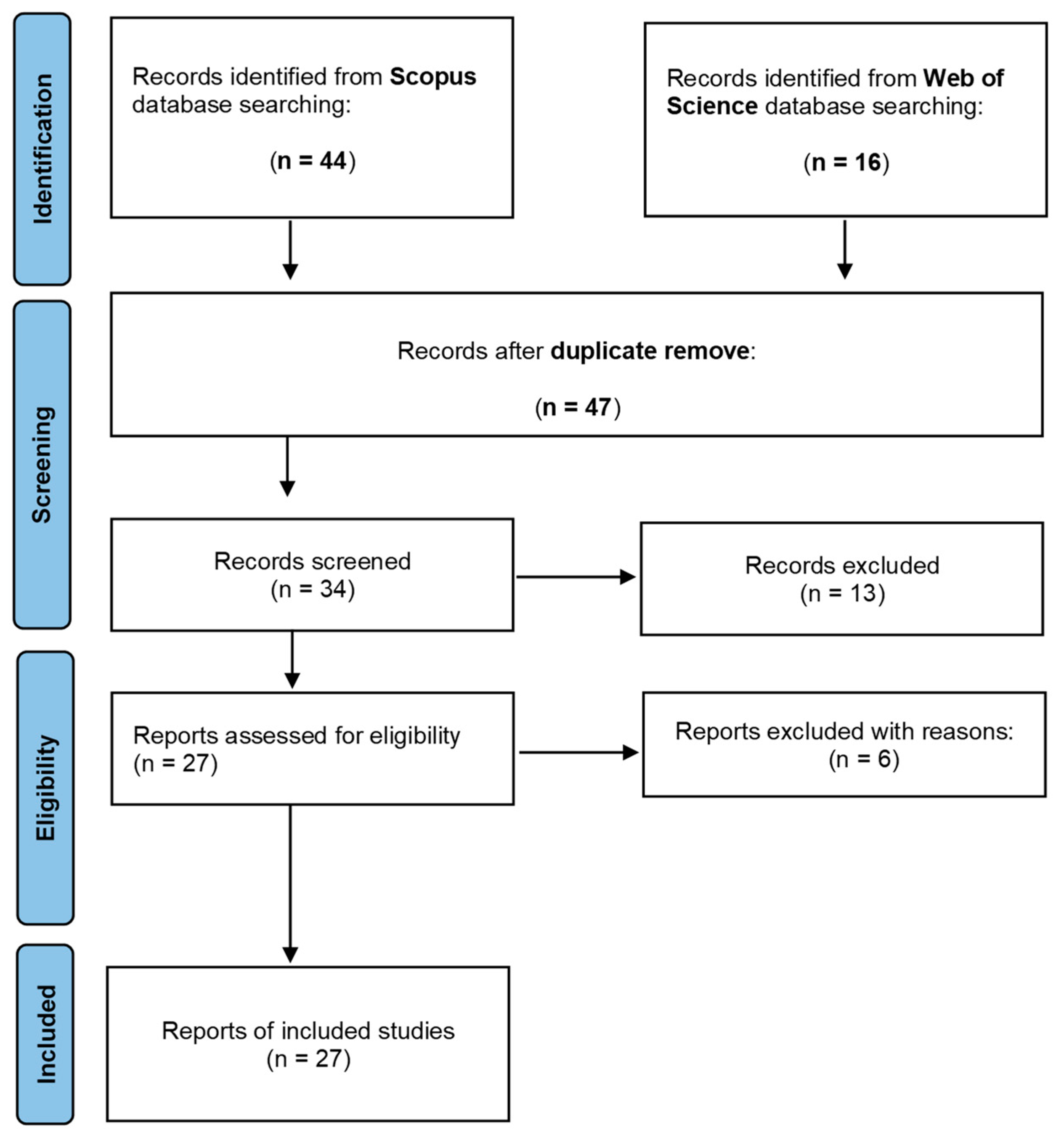
4.1.1. Identification

To identify the articles for inclusion in the review, a search was conducted in March 2021 (and updated until July 2021) in two databases indexing peer-reviewed articles: Scopus and Web of Science. These are considered among the principal databases for a systematic review [31]. The scope was defined as “the latest technological contributions in the deployment of Emergency Communications during a disaster”. For query keywords and results, see Table 3. It is worth noting that there is an almost unlimited number of technologies that could fall within the topic “emergency communications system” that have been used throughout history. Therefore, in order to limit the number of results to a feasible amount, capture the most recent contributions, maintain relevance, and keep the scope as open as possible, the searches have been filtered to Open Access (OA) papers. The increasing amount of OA papers in recent years [32] makes this filter suitable in our case and enhances the replicability of this study.
Table 3. Identification queries and results per database.
DatabaseQueryResults
ScopusTITLE-ABS-KEY (“emergency communications” AND disaster) AND (LIMIT-TO (OA, “all”)) AND (LIMIT-TO (PUBYEAR, 2021) OR LIMIT-TO (PUBYEAR, 2020) OR LIMIT-TO (PUBYEAR, 2019))44
Web of ScienceTOPIC: (“emergency communications” disaster) Refined by: OPEN ACCESS
Period of time: 2019–2021. Database: WOS.
16

4.1.2. Screening

After removing duplicates, 47 articles were screened by reading their titles and abstracts. The screening criteria were:
  • only articles addressing the technological deployment of ECS;
  • only articles about the communication systems during the emergency (no prevention and neither post-emergency recovery);
  • only articles reporting ECS technologies from the last five years (2017–2021).
During the screening process, 13 articles were discarded, leaving 34 articles for the eligibility phase. Out of these 13 excluded articles, 2 articles referred to ECS from 2009 to 2013, 10 articles did not include any technologic contribution but focused on the social aspects of the communications during emergencies, and 1 article did not refer to the deployment of an ECS during the emergency but focused on the post-disaster communication network recovering.

4.1.3. Eligibility

During the eligibility phase, the 34 articles were distributed among the authors for a full text analysis. The eligibility criteria were as follows:
  • only articles including a technological contribution to the deployment of ECS;
  • only articles about the communication systems during the emergency (no prevention and neither post-emergency recovery).
In this stage, 6 articles were excluded as ineligible and 27 articles were deemed eligible for inclusion and data extraction.
Out of these six excluded articles, three did not include any technological contribution, and three did not refer to an ECS deployment but to the recovery of the original communication network in the post-emergency phase.

4.1.4. Included

Finally, the eligible articles were processed to extract the information regarding the technologies being used, the technologic contributions being addressed, and the type of evaluations supporting those contributions. Table 4 presents the 27 articles with the corresponding data extraction.

4.2. Results

In total, 60 articles were first identified, of which 47 were left after eliminating duplicates, 34 were left after screening, and 27 were left after eligibility for the data extraction.
After the data processing of these 27 articles, several technologies have been identified, as well as the target contribution for each work. In this section, these technologies will be described and the corresponding technologic challenges addressed.
As introduced in Section 2 on Emergency Communications Systems and in the desk research of Section 3, three types of communications (with very different requirements) existing in an Emergency Scenario will be distinguished.
First, there is a Short Range (SH) category including all the communications between the people/objects within the area of the emergency. This category includes, for example, the communication between survivors and FRs, which is crucial to alleviate post-disaster consequences and save lives.
Second, the CIRS category includes all the communications related to the coordination of the rescue, as, for example, the communication from the CIRS to the people/objects of the emergency area or even the communication between several CIRSs.
Finally, depending on the character of the emergency event, residents of the affected area can also be informed about the emergency by alerting, warning, and notification systems of the state. The Warning System (WS) category provides the required reliable performance of warning and notification systems for the population.

4.2.1. Short Range Communications

Most of the research works identified in this systematic review are addressing this category. As stated previously, not only it is crucial for saving lives and alleviating post-disaster consequences, but these are the most affected communications within an emergency.

Aerial Wireless Networks

Within this category, Aerial Wireless Networks is the most researched topic, but, as it will be described herein, it is addressed from many different perspectives by the research community, as, indeed, the most suitable technology and the main issue to be solved will depend on the size of the stricken-area to be covered, the density and mobility of people/objects to be connected, the type and amount of data to be transmitted, and the available information regarding the location of all the network nodes, etc.
For example, in [24], they focus on a large emergency area (4 km × 4 km) and, thus, use multicopters to construct a wireless relay network in the sky, which serves as a backbone network. Each multicopter operates as an access point and accommodates user nodes on the ground. Then, a packet that is generated by a source node is transmitted to a destination node through the AWRN. If a multicopter exists in the communication range of another multicopter, they can forward packets to each other. Otherwise, the packets are conveyed by the movement of the multicopters. In this scenario, it is not easy to supply many multicopters to cover the emergency area, and thus, the main challenge is how to reduce the significant delay time of packet transmission caused by multicopters’ movement. Minimizing the delay time depends on how the multicopters move, which is referred to as flight schemes in the literature, and ref. [24] (considering 16 multicopters) is a good reference for any researcher interested in this topic. Finally, it also includes a good comparison between balloon-based AWRNs and multicopters’ UAVs and AWRNs.
On the other hand, in [44], they consider an emergency communication network where a single UAV aims to achieve complete coverage of potential underlaying device-to-device (D2D) users. In their work, trajectory planning issues are grouped into clustering and supplementary phases for optimization, and thus, UAVs’ energy consumption is reduced and the quality of D2D users’ communication is improved. However, this work is not applicable if the ground terminals dynamically change their position.
Furthermore, in [41], they explore the use of a single UAV, but to provide backhaul connectivity to truck-mounted Base Stations (BSs) that have been deployed within a disaster zone to provide network coverage to users based on the principle of delay-tolerant communications. They propose a trajectory design that uses genetic algorithm to find the trajectory with the least energy requirement for the UAV to visit all the BSs and return to a central node that acts as a gateway to the core network.
Delay tolerant networks (DTNs) use the method of a “store-carry-forward” to transfer messages, which is suitable for the large transmission delay and intermittent link communication. In [43], the DTNs based on a regional centre node and a UAV as ferry node are proposed to build the post-disaster emergency communication network. Further, a region-based message selective delivery routing policy is proposed for the emergency communication network. The received messages are classified according to their destination address at the regional centre node and the UAV ferry node. In this way, the data packets can be accurately delivered to the corresponding area, and redundant data packets will be reduced in the network, reducing delay.
Another important research goal of UAVs equipped with BS network coverage control is to maximize the network coverage under the condition of maintaining the service quality. In view of the low dynamic coverage ratio of UAVs equipped with base station network, ref. [56] proposes a relative distance-based UAV equipped with base station deployment method. The UAV realizes on-demand coverage and maintains a stable network topology under the influence of three relative distances by sensing the uncovered area of the ground, the neighbouring UAVs, and the location of the coverage boundary or obstacles. Finally, ref. [57] also considers a UAV-BS to serve a group of users in the downlink who have different statistical delay-bound QoS requirements in an emergency situation. They address the problem of maximizing the sum statistical-QoS-guaranteed throughput (effective capacity) of all users by jointly optimizing the UAV’s 3D location, power, and bandwidth allocation under each user’s statistical QoS requirement constraint.
Nevertheless, none of the previous studies have dealt with multiuser bandwidth assignment jointly with multiple UAVs’ mobility and energy budget in air–ground collaborative networks, which are critically important for the cooperation between terrestrial base stations and UAVs. Driven by this concern, ref. [51] focuses on the resource allocation optimization of UAV-enabled air–ground collaborative emergency networks, aiming at the maximization of signal rate of all users.
In [40], the novelty of the authors’ work is to optimally place available UAVs in 3D space to meet the objectives prominent during emergency situations. The objectives considered here are coverage, QoS, energy consumption, and two newly characterized objectives, i.e., equal load distribution over UAVs and fault tolerance for improving network connectivity and lifetime. In a similar line, ref. [50] proposes a joint 3D positioning and power allocation algorithm based on Reinforcement Learning (RL), more specifically Q-learning. Assuming an area in which a catastrophe has occurred, destroying the previous wireless communication infrastructure, the aim is to deploy a flexible and efficient local area Emergency Communication Network based on Drone Small Cells (DSCs). The proposed solution determines the more appropriate position and transmit power of each DSC to minimize overall user outage, therefore improving the network performance. Ref. [53] also presents a drones-based resilient communication infrastructure based on DSCs. The system not only addresses the ad-hoc on-demand formation of cells to re-establish communications but also optimizes the communication MAC layer based on priority and delay minimizations, with a clear focus on emergency communication needs.
From a completely distinct perspective, ref. [34] proposes to integrate a Software Defined Network into disaster emergency UAVs networks to realize the flexible deployment and management of high dynamic disaster area networks. In this case, the main challenge is to increase network lifetime and reduce node switching time and power consumption. The work intends to start from reducing the signalling overhead between controllers to further save system resources and improve the lifetime of the emergency disaster rescue UAV network. In their method, a multi-controller cluster drone architecture is used to create a backbone network with variable topology, which can provide long-term stable network coverage service in disaster emergency communication network construction.

Communication Technologies Integration

As can be seen up to now, a lot of works included in this systematic review focus on the deployment of Aerial Wireless Networks from several different perspectives. However, none of the papers presented until now include any integrated solution. Not surprisingly, in this short range category, there are also some works including Internet of Things (IoT) technologies. Indeed, the following highlighted works integrate Aerial Wireless Network technologies with IoT.
Ref. [58], for example, studies the network performance of collaboration between the Internet of Public Safety Things (IoPST) and drones, as this collaboration can support public safety requirements such as real-time analytics, real-time monitoring, and enhanced decision-making to help smart cities meet their public safety requirements. The contribution of this work lies in improving the level of public safety in smart cities through collaborating between smart wearable devices and drone technology. Thus, the collaboration between drones and IoPST devices establishes a public safety network that shows satisfying results in terms of enhancing efficiency and information accuracy.
More in line with the previous references, in [38], an emergency communications framework of NOMA-based UAV-aided networks is established. The addressed disaster scenarios are divided into three broad categories, referred to as emergency areas, wide areas, and dense areas. First, a UAV-enabled uplink NOMA system is presented to gather information from IoT devices in emergency areas (with a DQL-based path planning algorithm to identify the priority devices). Then, a joint UAV deployment and resource allocation scheme for a multi-UAV enabled NOMA system is developed to extend the UAV coverage for IoT devices in wide areas. Furthermore, a UAV equipped with an antenna array has been considered to provide wireless service for multiple devices that are densely distributed in disaster areas. Simulation results are provided to validate the effectiveness of the above three schemes.
A couple of even more relevant works, from our point of view, also integrate SWIPT technology in the integration of Aerial Wireless Networks and IoT. Ref. [37] establishes an emergency communications framework of UAV-enabled SWIPT for IoT networks. First, the trajectory optimization and beam pattern design have been investigated to deliver energy for IoT devices in densely distributed areas. Then, a trajectory planning and resource scheduling scheme has been established to provide wide-area wireless services for users. Furthermore, a dynamic path planning scheme with an intelligent prediction mechanism is established to improve the EE of the system. In line with this last point, in [36], an efficient UAV-assisted emergency communication with clustering techniques was adopted in which an optimal cluster head was introduced and utilized to harvest energy for stable networks that enhanced the network coverage and reliability.
Finally, in [33], a wireless emergency communication relay system based on a single tethered UAV is presented. From the perspective of practical application in a maritime emergency, the characteristics and network coverage of the emergency communication system are analysed. The tethered UAV is equipped with various communication loads such as a MESH self-networking relay station, 4G-LTE (long term evolution fourth generation mobile communication) base station including NB-IOT narrowband Internet of Things function, AIS (Automatic Identification System), and so on. When the communication support ship enters the scene of maritime emergencies, the tethered UAV platform lifts off, stays for a long time, and realizes the relay communication service of various carriers within a radius of tens of kilometres through its various communication payloads, which provides key communication support for the Marine emergency communication network. Indeed, ref. [33] is a relevant reference, not only because a real pilot is presented (while, in most of the other references, only simulations take place), but also because it considers the integration of many communication technologies (including the existing ones in maritime emergency scenarios, such as AIS).
Although most of the works described so far focus on the performance optimization, other identified requirements such as security, standards, or computation capabilities, among others, are also addressed in the literature.
The third-generation partnership project long-term evolution (GPP-LTE) broadband standard, for example, is a key enabler for the emergency communication services in public safety (PS) situations. In [48], the authors reviewed the communication services enabler in PS-LTE. The 3GPP status of various PS-LTE related services such as proximity services, emergency calls, IOPS, public warning system, and mission critical services are presented. They propose a three-layered Disaster Resilient (DR)-PS-LTE architecture that can meet the strict latency requirements by processing essential functions at the edge and can also be centrally managed using SDN functionality and using UAVs cloudlet for distributed processing. Simulation results show that the proposed DR-PSLTE architecture achieved 20 percent less delay and has low energy consumption as compared to conventional centralized computing.
In the same line of distributed computing, ref. [49] presents a detailed mathematical model to represent data processing and transmission in an emergency communication fog network, an NP-hard proof for the problem of optimizing the overall delay, and a novel algorithm to minimize the overall delay for wirelessly networked disaster areas (WNDA) that can be run in real-time. They evaluate the systems across various transmission speeds, processing speeds, and network sizes and tested the calculation time, accuracy, and percent error of the systems. Through evaluation, they found that the proposed disaster area adaptive delay minimization (DAADM) algorithm showed to have a reduced overall delay over various network sizes when compared to some conventional solutions. The DAADM had one major advantage over the Genetic Algorithms (GAs), and that was the processing time, which allows the DAADM to be implemented in a real-time system, where a GA solution would take far too much time.
Ref. [46] envisions a privacy-preserving federated learning enabled buses-and-drones based mobile edge infrastructure (ppFL-AidLife) for disaster or pandemic emergency communications. The ppFL-AidLife system aims at a rapidly deployable resilient network capable of supporting flexible, privacy-preserving, and low-latency communications to serve large-scale disaster situations by utilizing the existing public transport networks, associated with drones to maximally extend their radio coverage to those hard-to-reach disasters or should-not-close-contact pandemic zones.
Finally, in [57], all the three categories—SH, CIRS, and WS—are addressed. A UAV-assisted emergency Wi-Fi network is proposed to expedite the rescue operations by guiding the survivors to the nearest rescue camp location. Here, the Raspberry PI (RPI) development board, mounted on UAV, is considered to form a Wi-Fi chain network over the disaster region. The designed UAV network can do on-site surveillance and transmit the data to the relief centre for better rescue planning and to alert a survivor about the emergency network by designing a captive portal. Furthermore, to extend the Wi-Fi network, an Android-based application is developed by which each smartphone acts as a relay for its neighbour. Three types of field experiments are carried out to evaluate the performance of the designed prototype. It is found from the field results that the Wi-Fi access point mode and user datagram protocol are more suitable for network design as compared to ad-hoc mode and transmission control protocol, respectively. It is also observed from the experiment that the maximum hop distance for the prototype is 280 m and 290 m for a Wi-Fi configuration following IEEE 802.11n and IEEE 802.11ac protocol, respectively.

Space Communication Technologies

Even if Aerial Wireless Networks could be complementary to any other communication technology, there are, of course, still many research works completely focused on other emergency communications.
For example, space communications are indeed an important focus of research. Ref. [39] describes the performance of tethered balloon technology as one of the space technologies for public and emergency communications. It focuses on the analysis of the optimal performance of proposed technology for delivering services to rescue and relief teams in emergency situations. The results show that rescue and relief teams are given high priority for performing their duty effectively and efficiently, and their ability to evaluate the performance of the proposed technology, delay, throughput, traffic in both directions, and SNR is considered in testing network performance.
Satellite communications are also essential when all the other communications systems are unavailable. An interesting research work on the application and development of a grid of inter-satellite connections and calculation algorithms is proposed in [52]. The main objective is to contribute to the construction of a location-based integrated network communication between satellites and earth, as well as the realization of more efficient space-based information intelligent services. However, since this is the first study on application of the grid system to the interconnection algorithm of low-orbit satellite constellations, there are still many issues worthy of in-depth study.

Prioritization and Categorization in ECS

Another interesting line of research, not so much linked to the communication technology performance but to the need of defining priorities and or categories on the transmissions in emergency situations, is prioritization and categorization in ECS. The following works address this issue from completely different approaches.
To satisfy different data transmission requirements and solve the post-disaster problems, ref. [35] proposes a solution for the routing decision problem with multiple QoS constraints based on the Fuzzy Decision Theory (FDT) and the proposed fuzzy-logic-based data-differentiated service supported routing protocol (FDDSP). In this article, the data types are divided into emergency data and regular data. Emergency data require real-time and reliable transmissions, while regular data require a high throughput and balanced energy consumption. FDDSP chooses different Fuzzy Decision Systems to make routing decisions for several types of data and provides differentiated data services to optimize the transmission quality.
In [54], they focus on the communication between different emergency response team members. Indeed, when dedicated roles and missions are assigned to responders, role-based communication is a pivotal feature that an emergency communication network needs to support. The authors design and implement a Named Data Networking (NDN)-based disaster response support system over edge computing infrastructure, with KubeEdge as the chosen edge platform to solve the above issues. Their proof-of-concept system performance shows that the architecture achieved efficient role-based communication support, fast mobility handover duration, quick network convergence time in case of node replacement, and loss-free information exchange between responders and the management centre on the cloud.

Other Wireless Communication Technologies

Finally, the following references include other specific works on wireless communications, independent from the categories identified so far.
The objective of the study in [42] was, first, to construct an improvised antenna to be tested on an area with no cellular network and test the router’s operating range using it, and second, to design and develop a mobile multimedia messaging application that utilizes WLAN to send data. Results of the testing show that an improvised antenna achieved an operating range of 192 m, the range achieved 215 m in area with no cellular network, and the application could send multimedia messages over WLAN.
Ref. [45] proposes to build ad hoc subnetworks of disconnected smartphones using the Wi-Fi tethering technology and connect them to either the emergency communication equipment deployed in the disaster area or to other smartphones that still have the network connectivity.
In [55], they tackle two key technological solutions for future emergency communication networks, such as an architecture based on relay nodes and enhanced user equipment by means of multiple-input-multiple-output (MIMO) textile technology. They implement a real large textile antenna array deployed at user jacket backside.

4.2.2. CIRS Communications

Although the research on CIRS communications is by far not so abundant as in the SR communications described previously, in this section, the technologies related to CIRS, which have been gathered from this systematic review, are identified. They have been grouped by the corresponding main technology, but in some works, several communication technologies will be identified.

Mobile Communications Technologies

As mentioned before, ref. [48] presents a disaster resilient three-layered architecture for PS-LTE. This architecture consists of an SDN layer to provide centralized control, UAV cloudlet layer to facilitate edge computing or to enable the emergency communication link, and a radio access layer. Indeed, the CIRS communications are based on D2D communications over LTE, and the paper describes how the latest releases of 3GPP are working in the coexistence between LTE and other existing communication systems such as TETRA.
Even if [33] implements an emergency network for a maritime area of tens of kilometres, and thus has been previously analysed as a SR category work, many references appear in the paper referring to the shore-based data centre. The coordination of the emergency is conducted by both the “communication command ship” (tens of kilometres of the emergency area) and the “coordination centre on-shore”, and indeed, when the communication link with the shore base fails, the proposed solution based on a tethered UAV platform can also use the local LTE system to operate in the island mode and still play a certain role in the field emergency communication. Furthermore, it is also mentioned that the internet access based on shore can be realized by satellite communication link and microwave line of sight communication equipment, although these technologies are not further developed in the paper.
In [46], the focus is also on the emergency short range communications based on a privacy-preserving federated learning embedded buses-and-drones mobile edge infrastructure. However, as in the previous references, the coordination is seen as a two-fold work, first conducted by the buses equipped as Emergency Control Centres at a local level—and only in the optimistic case are there still some terrestrial BSs working or accessible—then, the buses-and-drones federated edge infrastructure can be further connected to the global infrastructure through these still-working and accessible BSs and thus connected to CIRS far from the emergency area.

Wired and/or Wireless Communications to Internet

Ref. [35] is focused on a solution based on fuzzy logic for the routing decision problem for an underground mine wireless-communication. While most of its contribution affects the SR communications inside the underground mine, it also mentions the commonly used method of drilling in the blocking area and installing a wireless access point (AP) or gateway through the hole to connect the ground backbone network (Ethernet) with the emergency communication network in an underground mine, which could be used for the coordination communications (CIRS).
Ref. [41] proposes a quick, efficient, and low-cost post-disaster wireless communication deployment whereby a truck-mounted BS is deployed to clusters of users within a disaster zone. It is assumed that the BSs do not have any form of backhaul capability to the core network and, as such, rely on a UAV to periodically come for a fly-by to receive the data from each BS and ferry it to the core network (represented by a gateway), or vice versa. Thus, BSs serve for SR communications in the clusters of users, but the main goal of the UAV in this work is to forward all the communications to the core network and thus prove useful for coordination purposes (CIRS). In the same line, in [43], Delay Tolerant Networks based on a regional centre node and a UAV as ferry node are proposed to build the post-disaster emergency communication network. However, in this case, the focus of the contribution is on the SR communication (exchange of information between the BSs), while the objective of communication with the core network is just briefly mentioned.
Ref. [45] proposes Wi-Fi tethering to build ad-hoc subnetworks of disconnected smartphones in emergency areas. However, their solution implies an Emergency Command Centre (ECC) far away from the affected area, which coordinates not only the FRs, but also the proposed network deployment. In this line, some assumptions regarding the CIRS communications are described. In particular, the backhauls of the network consist of gateway devices, including smartphones with surviving/established cellular links and emergency APs, or surviving base stations and “Cell On Wheels” (COWs) in their limited coverage area. The COWs are mobile, portable cell towers and transceivers mounted on trailers or trucks for easy deployment in the affected areas. Furthermore, the emergency Wi-Fi APs are deployed in conjunction with the satellite gateways in the affected region. Each satellite gateway is composed of a very-small aperture-terminal (VSAT) dish antenna and a satellite modem that can be easily assembled and disassembled for portability. When the road connectivity is available, the Wi-Fi APs with satellite gateways are deployed at various locations in the affected region with the help of emergency vehicles. If no road connectivity is available in the affected region, then the equipment can be carried or air-dropped by emergency crews and deployed similarly. Since the APs are intended exclusively for assisting with the emergency network, they assume that they are pre-authenticated by the ECC and connected to the ECC using traditional technologies, such as satellite networks.

Satellite Communications Technologies

Finally, satellite communications, although already mentioned in some of the previous references ([33,45]), are also one of the most important technologies related to CIRS communications identified in our systematic review.
In particular, research in [52] is based on the background of space-based big data and satellite internet, combined with low-orbit satellite constellations and a complex network communication environment. The application and development of the grid inter-satellite connection and calculation algorithm proposed in this study is not only applicable to remote sensing constellations, but it is also applicable to other constellations that require interconnection, such as communication and navigation. The algorithm, thus, can be used in emergency communications, disaster warning, and maritime rescue, and can contribute to the next generation of satellite internet and “satellite-ground” integrated networks.
In [57], LEO Satellite is proposed as the backhaul node for connecting the UAVs to the core network, as LEO satellite networks also have short transmission delay, large bandwidth, and small path loss characteristics.

4.2.3. Warning Systems Communications

Warning Systems (WS) Communications have only been identified tangentially in a couple of works. For example, the public-warning system (PWS) is one of the use cases for the PS-LTE system presented in [48]. Earthquake sensor nodes could be installed to gather the shock information and transmit it to the CIRS to enable coordination operations. The CIRSs request mobile operators to broadcast public warning alerts to the users in their vicinity. The public warning system (PWS) is an alert-based system that is used for the delivery of short messages in case of emergency or disaster situations. The paper claims that many Public Warning Systems have been deployed all over the world, such as commercial mobile alert system (CMAS), earthquake and tsunami warning system (ETWS), Korean public alert system (KPAS), European (EU)-ALERT, and Austria public alert system. The notification latency varies with these systems, but usually it should be delivered within four seconds to users in the notification area.
Additionally, in [45], the authors propose to link their proposed app to official emergency alert systems, such as the Wireless Emergency Alert (WEA) from the US, because most cellular service providers in the US implement WEA supported in all Android/IOS phones. Indeed, WEA messages ride on the control channel and thus are not affected by the network congestion.

5. Discussion

This section highlights and discusses the main conclusions derived from the literature review and proposes some future work directions.

5.1. Conclusions of the Literature Review

The 27 papers included in this systematic reviewed have been described with a special focus on the technologies addressed either for short range communications (between FRs and/or users/objects in the affected area), for CIRS communications from the affected area to coordination offices, or between several coordination offices, and warning systems communication for broadcasting important information to the entire population.
Table 5 shows a summary of the most relevant information extracted from each of the references. First, the communication technologies addressed, second, the type of communications considered, third, the communication layer affected by the research, and fourth, the ECS Requirements (from Section 2) targeted by the works.
Regarding the technologies, the importance of Aerial Wireless Networks as a rising topic of interest (already mentioned in the desk research) has been confirmed, but their actual relevance within this review is surprising, considering that many of the reviews analysed in Section 3 hardly mentioned them.
Furthermore, it can be concluded that most of the works included the integration of several technologies, but the most prominent issue is that the integration itself is hardly ever addressed, but very often identified in the future lines of research.
Regarding the types of communications, it has been identified that most of the references only focus on the SR communications, only sometimes including a brief reference to a possible backhaul node to connect to the core network. This is probably because the emergency affected area is where the most challenging scenario related to Aerial Wireless Networks and the deployment of new communication networks can be located. Nevertheless, any Emergency Communication System needs to be addressed as a whole and without neglecting the existing technologies, and in this line, only a couple of works have been identified.
From the ECS requirements point of view, most of the research works included in this review address them slightly, or even, many times, implicitly. That is, most of the references associate drones with scalability, fast deployment, and low-cost, but without really addressing them, and focusing only on the network robustness or reliability of the Aerial Wireless Network. Moreover, voice and data support are mentioned as possible network capabilities without including specific contributions or solutions for them. Nevertheless, due to the imposed requirement for the review to include at least some technological innovation, more general articles addressing many ECS requirements have been discarded (by the defined search criteria), and thus, in this part of the review, all the ECS requirements addressed by each work in more or less depth have been included in Table 5.
Finally, Table 5 also includes the extracted information regarding the communication layer being addressed by each work, as this information will be very useful in the next section of this paper, where the mapping of the identified technologies into a proposed architecture will be conducted as part of the discussion derived from the conclusions extracted from this systematic review.

5.2. Future Work Directions

As has been shown in previous sections, there are a plethora of techniques and technologies to address the communication challenges that arise in emergency situations. Although these solutions have proved to operate successfully when needed, such a broad range of alternatives complicates the task of selecting the most appropriate set of technologies for each situation. In fact, there are several technological challenges to be addressed when providing a communications infrastructure for emergency situations: reliability, flexibility, dynamic behaviour, hostile scenarios, multi-vendor devices, and scalability. This section discusses the future work directions derived from this systematic literature review.
The first future work direction that this research envisages the construction of a formal taxonomy of technologies for ECS. Given the wide range of alternatives, it would result in massive help to provide a tool that identified the relations between the different technologies, their associated threats and strengths, and their typical use-cases. In addition, this taxonomy could include a cost analysis (which is often an oversight in the reviewed literature) for each technology so practitioners and system designers could reliably assess the cost effectiveness of each tool.
A very first step toward building this taxonomy could be to define a standard and structured framework to position and understand the interactions between each of the technologies required to implement an ECS. For instance, it would be possible to establish a mapping between the conception of a communications infrastructure for emergency situations and the well-known Ubiquitous Sensor Network (USN) layered model [59]. In fact, communications infrastructures for emergency situations share several similarities with the challenges faced by USNs [59]. In fact, in a USN, a dynamic set of heterogeneous sensors and actuators—which can be associated with FRs, citizens, or devices in the communications for emergency situations domain—with different capabilities are deployed and span a large-scale area in order to cooperate together. Therefore, there are some lessons that could be learned from the USN’s domain and exported to the communications for emergency situations use-case. The idea of the possible mapping between ECS and the USN layered model is further elaborated in what follows.
Table 5. Data analysis of the references included in the systematic review.
Works Ref.TechnologiesCommunication SystemCommunication LayerRequirements
[24]AWRN with multicopter UAVsSRAccessRapid deployment, Robustness and reliability, Scalability
[33]AWRN with tethered UAVs, optical fibre (drone-ship), mesh equipment, 4G-LTE, Automatic Identification System receiverSR, CIRSAccess + MiddlewareRapid deployment, Interoperability, Robustness and reliability, Scalability, Mobility, Scalability, Voice and Data support
[34]SDN-based UAV networkSRAccess + MiddlewareRapid deployment, Robustness and reliability,
[35]Hybrid wireless mesh networksSR, CIRSAccessRapid deployment, Robustness and reliability, Scalability, Voice and data support
[36]UAV-supported wireless networks (D2D communications), SWIP technologySRSensors + Access Rapid deployment, Robustness and reliability
[37]UAV-enabled SWIP technology, IoTSRSensors + AccessRapid deployment, Robustness and reliability, Scalability
[38]NOMA-based UAV-aided wireless network, IoTSRSensors + AccessRapid deployment, Robustness and reliability, Scalability
[39]Tethered balloon, WiMaxSRAccessRapid deployment, Robustness and reliability, Voice and Data support, Scalability, Interoperability, Cost
[40]Aerial wireless mesh networksSRAccessRapid deployment, Robustness and reliability, Voice and Data support, Scalability
[41]UAV transporting data from and to truck-mounted BSs, Delay Tolerant NetworksCIRS, SR Sensor + AccessRapid deployment, Robustness and reliability, Scalability, Cost
[42]IEEE 802.11 compliant antenna with WLAN mobile multimedia applicationSRSensorRapid deployment
[43]Delay Tolerant Networks + UAVsSR, CIRSSensor + AccessRapid deployment, Robustness and reliability, Scalability
[44]UAVs + D2D communicationsSRSensor + AccessRobustness and reliability
[45]Ad-hoc networks, Wi-Fi tetheringSR, CIRS, WSSensorRapid deployment, Robustness and reliability, Scalability
[46]5G UAVs-assisted mobile edge communications, networking, privacy-preserving FMLSR, CIRSAccessRapid deployment, Robustness and reliability, Scalability, Security
[47]Wi-Fi network on DronesSRSensor + AccessRapid deployment, Robustness and reliability, Scalability, Cost
[48]3GPP standard, PS-LTE, UAV cloudlets, SDN, edge computingSR, CIRS, WSSensor + Access + MiddlewareRapid deployment, Robustness and reliability, Voice and Data support, Scalability, Security
[49]Fog computing, Movable BS, Wireless NetworkSRSensor + Access + MiddlewareRapid deployment, Robustness and reliability, Scalability, Mobility
[50]Drone Small Cells, Reinforcement Learning (3D positioning and power allocation)SRSensor + AccessRapid deployment, Robustness and reliability, Scalability, Mobility
[51]UAVs-enabled air-ground collaborative emergency network, Aerial Mobile Base StationsSRSensor + AccessRapid deployment, Robustness and reliability, Scalability, Mobility
[52]Satellite Constellation NetworkCIRS, SRAccessRapid deployment, Robustness and reliability
[53]Drones Small Cells, MobileSRAccessRapid deployment, Robustness and reliability
[54]Name Data Networking, Edge ComputingSRSensor + Access + MiddlewareRobustness and reliability, mobility
[55]Relay network, LTE-A, MIMO textile technologySRSensor + AccessRapid deployment, Robustness and reliability, Voice and data support
[56]UAV-BSsSRSensor + AccessRapid deployment, Robustness and reliability
[57] UAV-BSs, Satellite LEOSR, CIRS, WSAccessRapid deployment, Robustness and reliability, Voice and data support
[58]Drones MANET, IoTSRSensor + AccessRapid deployment, Robustness and reliability
The International Telecommunication Union defined a layered model for a Ubiquitous Sensor Network [59]. This layered model is composed of four different components (i.e., sensor networking, access networking, middleware, and applications) and enables practitioners to naturally position a technology in its corresponding component(s), which, at the same time, eases the compatibility and interactions with other layers. This four-layer hierarchical approach could be used as a reference mode to organize and architect communication technologies for emergency situations. More specifically, these are:
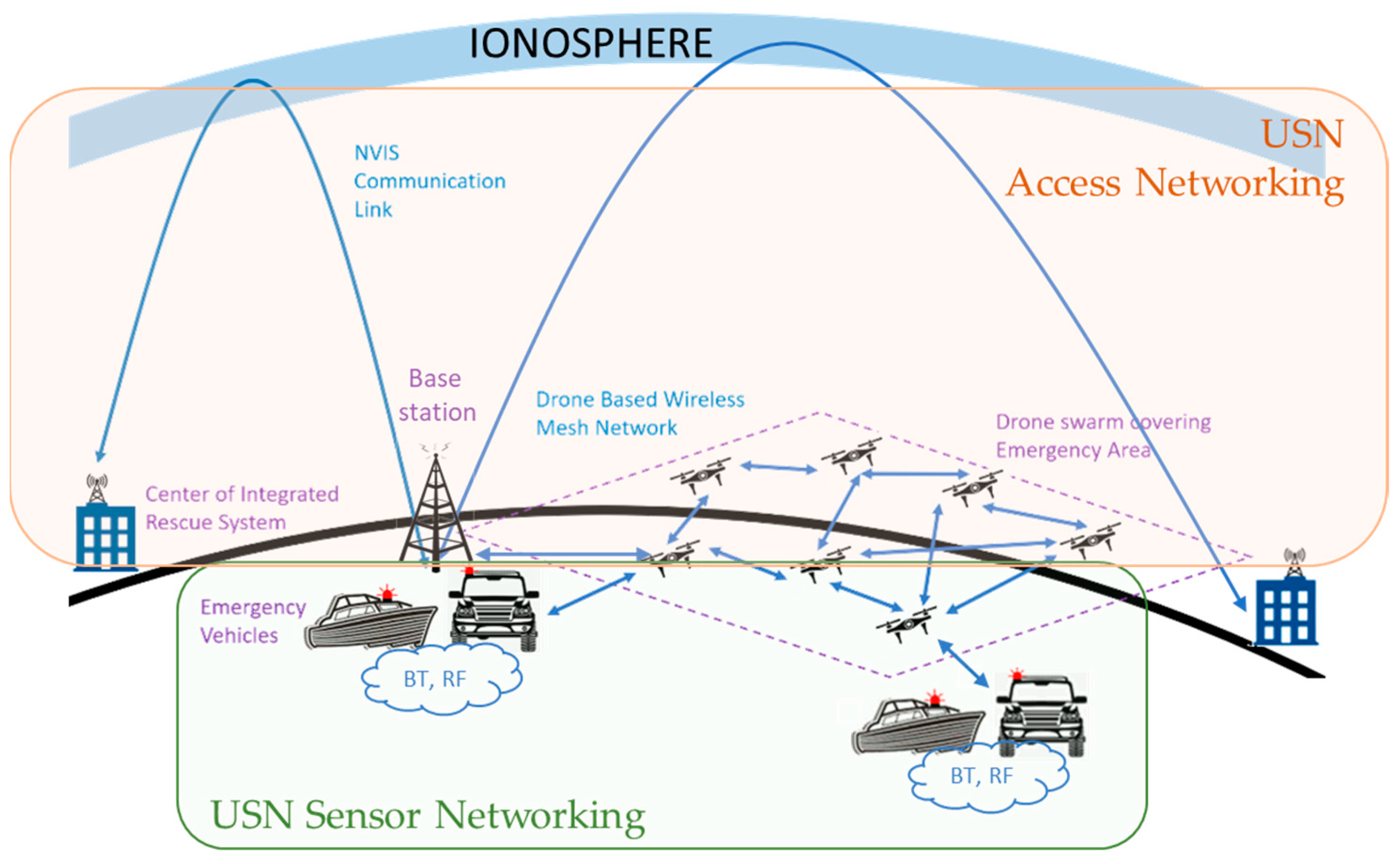
  • Sensor networking. This layer includes all the technologies aimed at enabling communications between in-field FRs (or even humans to be rescued). At this layer, the communication requirements share several similarities with those found at the sensing layer of Internet of Things domains. That is: short range, robustness, reduced size and power consumption, low bandwidth (i.e., mostly voice), real-time (i.e., few milliseconds).
  • Access networking. This layer includes all the technologies aimed at enabling communications between FRs and CIRS. At this layer, the communication requirements increase due to the fact that (1) all in-field data need to be aggregated and (2) critical information to properly manage the emergency needs to be reported—that is, medium range, reliable, medium bandwidth, flexibility, and near real-time (i.e., few hundreds of milliseconds). As this layer is committed to digitally link locations where there is no communication network (or the network has been destroyed itself due to the disaster), the ad-hoc networks composed of UAVs (see Section 4) can result in a convenient approach at this stage.
  • Middleware. This layer includes all the technologies aimed at enabling communications between different CIRSs. Compared to the access networking layer, at this point, the communication requirements are somehow different. In fact, each CIRS can operate autonomously for a moderately long period of time. Therefore, the communication requirements can be generally relaxed: while high bandwidth might be required (to exchange high-resolution pictures), the real-time notion can be extended up to a few seconds. Although this type of communication typically covers long range distances, already existing networks (e.g., Internet, LTE) are usually available at this stage.
  • Applications: This layer is aimed at supporting the high-end data-driven applications (also referred to as services) that support the different teams in charge of fighting the emergency, such as early-warning systems or advanced monitoring and analytics.
In fact, the most challenging layers, in terms of technology, are the Sensor and Access Networking layers, since they have to be typically deployed ad-hoc in harsh environments, very close to the location of the disaster.
In order to show the application of the aforementioned USN layered model to the ECS domain, Figure 2 proposes a possible communications technology stack to materialize these two layers. For instance, it would be possible to use (1) short range wireless communications such as Bluetooth (BT) and long range/low power communications such as LoRa/NB-IoT/LTE-M radiofrequency (RF) to communicate energy vehicles at the Sensor Networking layer, (2) a Near Vertical Incidence Skywave (NVIS) link [60] to connect FRs with the CIRS at the Access Networking layer, and (3) a Drone Based Wireless Mesh network (UAV) to extend the operational range of the Sensor Networking layer, which enables interconnection with different FRs teams. It is worth noting that the technologies selected for this example have been chosen in an academic context (i.e., with the aim of illustrating the applicability of the USN layered model to ECS) and do not aim to propose an ultimate solution to address the real-world implementation challenges of ECSs.
This architecture instantiation would also meet the requirements defined in the ITU T Y.1271 recommendation [9], especially those regarding pre-emption of non-emergency traffic to free bandwidth, restorability, mobility, and interoperability. Note that this proposal offers some interesting trade-offs. On the one hand, the NVIS technology enables HF communications (in the range between 3 MHz and 10 MHz, according to the status of the ionosphere [61]) with low bit-rates (up to 60 kbps) without the need for line-of-sight (i.e., electromagnetic waves are directed toward the ionosphere) in a surface with a radius up to 250 km [61] using a single-hop communication [62]. Although the bitrate might be too low for certain applications (e.g., real-time video), this inexpensive (compared to satellites) technology can operate in electromagnetically challenging scenarios such as wells, gorges, or canyons. On the other hand, as already seen in the systematic literature review, the UAV network greatly extends the range of the Access Networking layer, but it also may add a considerable delay onto the communications. Therefore, Delay Tolerant Network (DTN) protocols [63] shall be required to make these communications reliable and robust.

Author Contributions

Conceptualization, A.C.-C., J.N., C.S. and A.Z.; methodology, A.C.-C.; validation, A.C.-C., J.N., C.S. and A.Z.; investigation, A.C, C.S. and A.Z.; data curation, A.C.-C.; writing—original draft preparation, A.C.-C.; writing—review and editing, A.C.-C. and J.N.; visualization, A.C.-C.; supervision, A.Z. All authors have read and agreed to the published version of the manuscript.

Funding

This research was funded by the Spanish Ministry on Science, Innovation and University, the Investigation State Agency and the European Regional Development Fund (ERDF) under the grant number RTI2018-097066-B-I00 (MCIU/AEI/FEDER, UE) for the project “NVIS SENSOR NETWORK FOR THE SOUTH SHETLAND ISLANDS ARCHIPELAGO” (SHETLAND-NET).

Institutional Review Board Statement

Not applicable.

Informed Consent Statement

Not applicable.

Data Availability Statement

All data generated or analysed during this study are included in this published article.

Conflicts of Interest

The authors declare no conflict of interest.

References

  1. Richards, C. When communications infrastructure fails during a disaster. Disaster Recovery J. 2015. Available online: https://drj.com/journal_main/when-communications-infrastructure-fails-during-a-disaster/ (accessed on 24 February 2022).
  2. World Bank. Communication during Disaster Recovery; Disaster Recovery Guidance Series; World Bank: Washington, DC, USA, 2020. [Google Scholar]
  3. Huang, J.; Lien, Y. Challenges of emergency communication network for disaster response. In Proceedings of the IEEE International Conference on Communication Systems (ICCS), Singapore, 21–23 November 2012; pp. 528–532. [Google Scholar] [CrossRef]
  4. Radeva, N.; Panteleeva, M.; Romanova, H. Civil protection modern aspects in case of disasters—Bulgaria. J. IMAB-Annu. Proceeding Sci. Pap. 2017, 22, 1333–1337. [Google Scholar] [CrossRef] [Green Version]
  5. Morrison, K.T. Rapidly recovering from the catastrophic loss of a major telecommunications office. IEEE Commun. Mag. 2011, 49, 28–35. [Google Scholar] [CrossRef]
  6. Mayor, V.; Estepa, R.; Estepa, A.; Madinabeitia, G. Deploying a reliable UAV-aided communication service in disaster areas. Wirel. Commun. Mob. Comput. 2019, 2019, 7521513. [Google Scholar] [CrossRef] [Green Version]
  7. Liu, X.; Li, Z.; Zhao, N.; Meng, W.; Gui, G.; Chen, Y.; Adachi, F. Transceiver design and multihop D2D for UAV IoT coverage in disasters. IEEE Internet Things J. 2018, 6, 1803–1815. [Google Scholar] [CrossRef] [Green Version]
  8. Chaudhry, A.; Hafez, R. LMR and LTE for public safety in 700 MHz spectrum. Wirel. Commun. Mob. Comput. 2019, 2019, 7810546. [Google Scholar] [CrossRef]
  9. ITU-T Rec. Y.1271. Framework(s) on Network Requirements and Capabilities to Support Emergency Telecommunications over Evolving Circuit-Switched and Packet-Switched Networks. July 2014. Available online: https://www.itu.int/rec/dologin_pub.asp?lang=e&id=T-REC-Y.1271-201407-I!!PDF-E&type=items (accessed on 29 March 2022).
  10. Iapichino, G.; Bonnet, C.; del Rio Herrero, O.; Baudoin, C.; Isabelle, B. Advanced hybrid satellite and terrestrial system architecture for emergency mobile communications. In Proceedings of the 26th AIAA International Communications Satellite Systems Conference (CSSC 2008), San Diego, CA, USA, 10–12 June 2008. [Google Scholar] [CrossRef] [Green Version]
  11. Dilmaghani, R.; Rao, R. On designing communication networks for emergency situations. In Proceedings of the International Symposium on Technology and Society (ISTAS ‘06), Flushing, NY, USA, 8–10 June 2006. [Google Scholar] [CrossRef]
  12. Sahil; Sood, S.K. Bibliometric monitoring of research performance in ICT-based disaster management literature. Qual. Quant. Int. J. Methodol. 2021, 55, 103–132. [Google Scholar] [CrossRef]
  13. Motlagh, N.H.; Taleb, T.; Arouk, O. Low-altitude unmanned aerial vehicles-based internet of things services: Comprehensive survey and future perspectives. IEEE Internet Things J. 2016, 3, 899–922. [Google Scholar] [CrossRef]
  14. Erdelj, M.; Natalizio, E.; Chowdhury, K.R.; Akyidiz, I.F. Help from the sky: Leveraging UAVs for disaster management. IEEE Pervasive Comput. 2017, 16, 24–32. [Google Scholar] [CrossRef]
  15. Yanmaz, E.; Yahyanejad, S.; Rinner, B.; Hellwagner, H.; Bettstetter, C. Drone networks: Communications, coordination, and sensing. Ad Hoc Netw. 2018, 68, 1–15. [Google Scholar] [CrossRef]
  16. Pervez, F.; Qadir, J.; Khalil, M.; Yaqoob, T.; Ashraf, U.; Younis, S. Wireless technologies for emergency response: A comprehensive review and some guidelines. IEEE Access 2018, 6, 71814–71838. [Google Scholar] [CrossRef]
  17. Mohan, P.; Mittal, H. Review of ICT usage in disaster management. Int. J. Inf. Technol. 2020, 12, 955–962. [Google Scholar] [CrossRef]
  18. Kishorbhai, V.Y.; Vasantbhai, N.N. AON: A survey on emergency communication systems during a catastrophic disaster. Procedia Comput. Sci. 2017, 115, 838–845. [Google Scholar] [CrossRef]
  19. EL Khaled, Z.; Mcheick, H. Case studies of communications systems during harsh environments: A review of approaches, weaknesses, and limitations to improve quality of service. Int. J. Distrib. Sens. Netw. 2019, 15, 1550147719829960. [Google Scholar] [CrossRef] [Green Version]
  20. Deepak, D.C.; Ladas, A.; Sambo, Y.A.; Pervaiz, H.; Politis, C.; Imran, M.A. An overview of post-disaster emergency communication systems in the future networks. IEEE Wirel. Commun. 2019, 26, 132–139. [Google Scholar] [CrossRef] [Green Version]
  21. Wang, Y.; Xu, Y.; Zhang, Y.; Zhang, P. Hybrid satellite-aerial-terrestrial networks in emergency scenarios: A survey. China Commun. 2017, 14, 1–13. [Google Scholar] [CrossRef]
  22. Liu, Y.; Shi, Z.; Fadlullah, Z.M.; Kato, N. Space-air-ground integrated network: A survey. IEEE Commun. Surv. Tutor. 2018, 20, 2714–2741. [Google Scholar] [CrossRef]
  23. Zhang, S.; Zhu, D.; Wang, Y. A survey on space-aerial-terrestrial integrated 5G networks. Comput. Netw. 2020, 174, 107212. [Google Scholar] [CrossRef]
  24. Okada, H. An overview of aerial wireless relay networks for emergency communications during large-scale disasters. IEICE Trans. Commun. 2020, E103-B, 1376–1384. [Google Scholar] [CrossRef]
  25. Zaidi, S.; Atiquzzaman, M.; Calafate, C.T. Internet of flying things (IoFT): A survey. Comput. Commun. 2021, 165, 53–74. [Google Scholar] [CrossRef]
  26. Seba, A.; Nouali-Taboudjemat, N.; Badache, N.; Seba, H. A review on security challenges of wireless communications in disaster emergency response and crisis management situations. J. Netw. Comput. Appl. 2018, 126, 150–161. [Google Scholar] [CrossRef]
  27. Lu, Y.; Zheng, X. 6G: A survey on technologies, scenarios, challenges, and the related issues. J. Ind. Inf. Integr. 2020, 19, 100158. [Google Scholar] [CrossRef]
  28. Hu, Q.; Yang, W.; Ding, E.; Li, S.; Li, B. State-of-the-art and trend of emergency rescue communication technologies for coal mine. J. Commun. 2019, 40, 163–179. [Google Scholar] [CrossRef]
  29. Das, S.; Panda, K.G.; Sen, D.; Arif, W. A survey of national disaster communication systems and spectrum allocation—An Indian perspective. IETE Tech. Rev. 2020, 37, 111–136. [Google Scholar] [CrossRef]
  30. Page, M.J.; Moher, D.; Bossuyt, P.M.; Boutron, I.; Hoffmann, T.C.; Mulrow, C.D.; Shamseer, L.; Tetzlaff, J.M.; Akl, E.A.; Brennan, S.E.; et al. PRISMA 2020 explanation and elaboration: Updated guidance and exemplars for reporting systematic reviews. BMJ 2021, 372, 160. [Google Scholar] [CrossRef] [PubMed]
  31. Gusenbauer, M.; Haddaway, N.R. Which academic search systems are suitable for systematic reviews or meta-analyses? Evaluating retrieval qualities of Google Scholar, PubMed, and 26 other resources. Res. Synth. Methods 2020, 11, 181–217. [Google Scholar] [CrossRef] [PubMed] [Green Version]
  32. Hirt, J.; Nordhausen, T. Open access: How to ensure systematic searching? JEAHIL 2020, 16, 20–21. Available online: http://ojs.eahil.eu/ojs/index.php/JEAHIL/article/view/368 (accessed on 10 February 2022). [CrossRef]
  33. Xu, Z. Application research of tethered UAV platform in marine emergency communication network. J. Web Eng. 2021, 20, 491–512. [Google Scholar] [CrossRef]
  34. Zhou, J.; Yang, J.; Lu, L. Research on multi-UAV networks in disaster emergency communication. IOP Conf. Ser. Mater. Sci. Eng. 2020, 719, 012054. [Google Scholar] [CrossRef]
  35. Jiang, H.; Han, G.; Wang, H.; Li, X.; Zhang, G. Fuzzy-logic-based data-differentiated service supported routing protocol for emergency communication networks in underground mines. Int. J. Distrib. Sens. Netw. 2019, 15, 1550147719864762. [Google Scholar] [CrossRef] [Green Version]
  36. Saif, A.; Dimyati, K.; Noordin, K.A.; Deepak, G.C.; Shah, N.S.M.; Abdullah, Q.; Mohamad, M. An efficient energy harvesting and optimal clustering technique for sustainable postdisaster emergency communication systems. IEEE Access 2021, 9, 78188–78202. [Google Scholar] [CrossRef]
  37. Feng, W.; Tang, J.; Yu, Y.; Song, J.; Zhao, N.; Chen, G.; Wong, K.-K.; Chambers, J. UAV-enabled SWIPT in IoT networks for emergency communications. IEEE Wirel. Commun. 2020, 27, 140–147. [Google Scholar] [CrossRef]
  38. Feng, W.; Tang, J.; Yu, Y.; Song, J.; Zhao, N.; Chen, G.; Wong, K.-K.; Chambers, J. NOMA-based UAV-aided networks for emergency communications. China Commun. 2020, 17, 54–66. [Google Scholar] [CrossRef]
  39. Alsamhi, S.H.; Almalki, F.A.; Ma, O.; Ansari, S.; Angelides, M.C. Performance optimization of tethered balloon technology for public safety and emergency communications. Telecommun. Syst. 2020, 75, 235–244. [Google Scholar] [CrossRef]
  40. Gupta, M.; Varma, S. Metaheuristic-based optimal 3D positioning of UAVs forming aerial mesh network to provide emergency communication services. IET Commun. 2021, 15, 1297–1314. [Google Scholar] [CrossRef]
  41. Sambo, Y.A.; Klaine, P.V.; Nadas, J.P.B.; Imran, M.A. Energy minimization UAV trajectory design for delay-tolerant emergency communication. In Proceedings of the 2019 IEEE International Conference on Communications Workshops (ICC Workshops 2019), Shanghai, China, 20–24 May 2019; p. 8757127. [Google Scholar] [CrossRef]
  42. Musa, V.M.; Enriquez, J.B. Development of IEEE 802.11 compliant antenna with WLAN mobile multimedia messaging application for emergency communication purposes. Int. J. Recent Technol. Eng. 2019, 8, 1833–1838. [Google Scholar] [CrossRef]
  43. Xiong, X.; Liu, M.; Zhang, Y.; Zhang, N.; Chen, G.; Fu, M.; Cheng, Z. The effect of region-based message selective delivery strategy on post-disaster emergency network. J. Phys. Conf. Ser. 2020, 1486, 022005. [Google Scholar] [CrossRef]
  44. Zhang, S.; Shi, S.; Feng, T.; Gu, X. Trajectory planning in UAV emergency networks with potential underlaying D2D communication based on K-means. EURASIP J. Wirel. Commun. Netw. 2021, 1, 107. [Google Scholar] [CrossRef]
  45. Pal, A.; Raj, M.; Kant, K.; Das, S.K. A smartphone-based network architecture for post-disaster operations using WiFi tethering. ACM Trans. Internet Technol. 2020, 20, 6. [Google Scholar] [CrossRef] [Green Version]
  46. Ma, B.; Wu, J.; Liu, W.; Chiaraviglio, L.; Ming, X. Combating hard or soft disasters with privacy-preserving federated mobile buses-and-drones based Networks. In Proceedings of the 2020 IEEE 21st International Conference on Information Reuse and Integration for Data Science (IRI 2020), Las Vegas, NV, USA, 11–13 August 2020; pp. 31–36. [Google Scholar] [CrossRef]
  47. Panda, K.G.; Das, S.; Sen, D.; Arif, W. Design and deployment of UAV-aided post-disaster emergency network. IEEE Access 2020, 7, 102985–102999. [Google Scholar] [CrossRef]
  48. Kaleem, Z.; Yousaf, M.; Qamar, A.; Ahmad, A.; Duong, T.Q.; Choi, W.; Jamalipour, A. UAV-empowered disaster-resilient edge architecture for delay-sensitive communication. IEEE Netw. 2019, 33, 124–132. [Google Scholar] [CrossRef]
  49. Wang, Y.; Meyer, M.C.; Wang, J. Real-time delay minimization for data processing in wirelessly networked disaster areas. IEEE Access 2019, 7, 2928–2937. [Google Scholar] [CrossRef]
  50. De Paula Parisotto, R.; Klaine, P.V.; Nadas, J.P.B.; Souza, R.D.; Brante, G.; Imran, M.A. Drone base station positioning and power allocation using reinforcement learning. In Proceedings of the International Symposium on Wireless Communication Systems, Oulu, Finland, 27–30 August 2019; pp. 213–217. [Google Scholar] [CrossRef]
  51. Wu, L.; Wang, W. Resource allocation optimization of UAVs-enabled air-ground collaborative emergency network in disaster area. Int. J. Perform. Eng. 2019, 15, 2133–2144. [Google Scholar] [CrossRef]
  52. Li, S.; Hou, K.; Cheng, C.; Li, S.; Bo, C. A space-interconnection algorithm for satellite constellation based on spatial grid model. Remote Sens. 2020, 12, 2131. [Google Scholar] [CrossRef]
  53. Ali, K.; Nguyen, H.X.; Vien, Q.-T.; Shah, P.; Raza, M. Deployment of drone-based small cells for public safety communication system. IEEE Syst. J. 2020, 14, 2882–2891. [Google Scholar] [CrossRef]
  54. Tran, M.-N.; Kim, Y. Named data networking based disaster response support system over edge computing infrastructure. Electronics 2021, 10, 335. [Google Scholar] [CrossRef]
  55. Crespo-Bardera, E.; Vega Delgado, A.; Garrido Martín, A.; Fernández-Durán, A.; Sánchez-Fernández, M. Textile multiantenna technology and relaying architectures for emergency networks. Wirel. Commun. Mob. Comput. 2019, 2019, 7292075. [Google Scholar] [CrossRef] [Green Version]
  56. Zhao, T.; Wang, H.; Ma, Q. The coverage method of unmanned aerial vehicle mounted base station sensor network based on relative distance. Int. J. Distrib. Sens. Netw. 2020, 16, 1550147720920220. [Google Scholar] [CrossRef]
  57. Niu, H.; Zhao, X.; Li, J. 3D location and resource allocation optimization for UAV-enabled emergency networks under statistical QoS constraint. IEEE Access 2021, 9, 41566–41576. [Google Scholar] [CrossRef]
  58. Alsamhi, S.H.; Ma, O.; Ansari, M.S.; Gupta, S.K. Collaboration of drone and internet of public safety things in smart cities: An overview of qos and network performance optimization. Drones 2019, 3, 13. [Google Scholar] [CrossRef] [Green Version]
  59. ITU NGN-GSI Rapporteur Group Meeting. Draft Recommendation Y.USN-reqts. In Proceedings of the Requirements for Support of USN Applications and Services in NGN Environment, Geneva, Switzerland, 11–21 September 2007; Available online: http://www.itu.int/md/T05-NGN.GSI-DOC-0266/en (accessed on 10 February 2022).
  60. Maso, J.M.; Porte, J.; Pijoan, J.L.; Badia, D. Internet of things communications for remote sensors in Antarctica using NVIS. In Proceedings of the Nordic HF Conference, Fårö, Sweden, 12–14 August 2019; Available online: https://www.researchgate.net/publication/335774336_Internet_of_things_communications_for_remote_sensors_in_Antarctica_using_NVIS (accessed on 10 February 2022).
  61. Gonzalez, T.; Porte, J.; Male, J.; Navarro, J.; Maso, J.M.; Zaballos, A.; Pijoan, J.L.; Badia, D. SC-FDE layer for sensor networks in remote areas using NVIS communications. Electronics 2021, 10, 1636. [Google Scholar] [CrossRef]
  62. Porte, J.; Briones, A.; Maso, J.M.; Pares, C.; Zaballos, A.; Pijoan, J.L. Heterogeneous wireless IoT architecture for natural disaster monitorization. J. Wirel. Commun. Netw. 2020, 184, 184. [Google Scholar] [CrossRef]
  63. Mallorquí, A.; Zaballos, A.; Briones, A. DTN trustworthiness for permafrost telemetry IoT network. Remote Sens. 2021, 13, 4493. [Google Scholar] [CrossRef]
Figure 1. System review flow chart.
Electronics 11 01155 g001
Figure 2. Possible communications technology stack for emergency communications system.
Electronics 11 01155 g002
Table 4. Data extraction of the references included in the systematic review.
Ref.TitleComm. TechnologiesContributionEvaluation
[24]An overview of aerial wireless relay networks for emergency communications during large-scale disastersAWRN with multicopter UAVsDelay, flight schemes, CoverageSimulation
[33]Application Research of Tethered UAV Platform in Marine Emergency Communication NetworkAWRN with tethered UAVs, Optical fibre (drone-ship), Mesh equipment, 4G-LTE, Automatic Identification System receiverData transmission stability and reliabilityField test
[34]Research on Multi-UAV Networks in Disaster Emergency CommunicationSDN-based UAV networkFlight scheme, routing protocols (Network lifetime, and node switching time), Energy ConsumptionSimulation
[35]Fuzzy-logic-based data-differentiated service supported routing protocol for emergency communication networks in underground minesHybrid wireless mesh networksRouting protocol (delay, delivery ratio)Simulation
[36]An Efficient Energy Harvesting and Optimal Clustering Technique for Sustainable Post-Disaster Emergency Communication SystemsUAV-supported wireless networks (D2D communications), SWIP technologyEnergy consumption, network coverage, network reliabilitySimulation
[37]UAV-Enabled SWIPT in IoT Networks for Emergency CommunicationsUAV-enabled SWIP technology, IoTEnergy efficiency, network coverageSimulation
[38]NOMA-based UAV-aided networks for emergency communicationsNOMA-based UAV-aided wireless network, IoTHigh spectrum efficiency, massive connectionsSimulation
[39]Performance optimization of tethered balloon technology for public safety and emergency communicationsTethered balloon, WiMaxDelay, throughput, traffic in both directions, SNR Field test
[40]Metaheuristic-based optimal 3D positioning of UAVs forming aerial mesh network to provide emergency communication servicesAerial wireless mesh networksUAVs positioning (Coverage, QoS, Energy consumption, equal load distribution among UAVs, fault tolerance (network lifetime))Simulation
[41]Energy minimization UAV trajectory design for delay-tolerant emergency communicationUAV transporting data from and to truck-mounted BSs, Delay Tolerant NetworksTrajectory algorithm for energy efficiencySimulation
[42]Development of IEEE 802.11 compliant antenna with WLAN mobile multimedia messaging application for emergency communication purposesIEEE 802.11 compliant antenna with WLAN mobile multimedia applicationFunctionality, Reliability, Usability, Portability, Efficiency, MaintainabilityField test
[43]The effect of region-based message selective delivery strategy on post-disaster emergency networkDelay Tolerant Networks + UAVsRouting protocol (Transmission delay, data delivery rate, overhead ratio)Simulation
[44]Trajectory planning in UAV emergency networks with potential underlaying D2D communication based on K-meansUAVs + D2D communicationsUAV trajectory planning (communication performance, energy consumption)Simulation
[45]A Smartphone-based Network Architecture for Post-Disaster Operations Using Wi-Fi TetheringAd-hoc networks, Wi-Fi tetheringPerformance (power consumption)Prototype and simulation
[46]Combating Hard or Soft Disasters with Privacy-Preserving Federated Mobile Buses-And-Drones based Networks5G UAVs-assisted mobile edge communications, networking, privacy-preserving FMLPrivacy preserving, federated computationArchitecture proposal
[47]Design and deployment of UAV-aided post-disaster emergency networkWiFi network on DronesUDP/TCP throughput, hop distance, bitrateField test
[48]UAV-empowered disaster-resilient edge architecture for delay-sensitive communication3GPP standard, PS-LTE, UAV cloudlets, SDN, edge computingSystem delay, energy consumption, effect of increasing edge nodesSimulation
[49]Real-Time Delay Minimization for Data Processing in Wirelessly Networked Disaster AreasFog computing, Movable BS, Wireless NetworkSystem delaySimulation
[50]Drone base station positioning and power allocation using reinforcement learningDrone Small Cells, Reinforcement Learning (3D positioning and power allocation)Coverage (Position of drones)Simulation
[51]Resource allocation optimization of UAVs-enabled air-ground collaborative emergency network in disaster areaUAVs-enabled air-ground collaborative emergency network, Aerial Mobile Base StationsOptimization scheme (Bandwith assignment, drone trajectory, drone transmission power)Simulation (emulation)
[52]A space-interconnection algorithm for satellite constellation based on spatial grid modelSatellite Constellation NetworkGrid model (trajectory, coverage), visibility, network route planningSimulation
[53]Deployment of Drone-Based Small Cells for Public Safety Communication SystemDrones Small Cells, MobileThroughput, channel access delaySimulation
[54]Named data networking-based disaster response support system over edge computing infrastructureName Data Networking, Edge ComputingRole-based communication support, fast mobility handover duration, quick network convergence time in case of node replacement, loss-free information exchange between FR and the management centre on the cloudProof-of-concept, deployment
[55]Textile multiantenna technology and relaying architectures for emergency networksRelay network, LTE-A, MIMO textile technologyThroughout, connectivity/coverage (spectral efficiency) Simulation
[56]The coverage method of unmanned aerial vehicle mounted base station sensor network based on relative distanceUAV-BSsCoverageSimulation
[57] 3D Location and Resource Allocation Optimization for UAV-Enabled Emergency Networks under Statistical QoS ConstraintUAV-BSs, Satellite LEOUser’s QoS constraint (UAVs, 3D location, power, bandwidth allocation)Simulation
[58]Collaboration of drone and internet of public safety things in smart cities: An overview of QoS and network performance optimizationDrones MANET, IoTNetwork efficiency and accuracy (throughput, delay), probability of LoSSimulation
Publisher’s Note: MDPI stays neutral with regard to jurisdictional claims in published maps and institutional affiliations.

