


Participatory Approach to Build Up a Municipal Strategy for Coastal Erosion Mitigation and Adaptation to Climate Change


Abstract
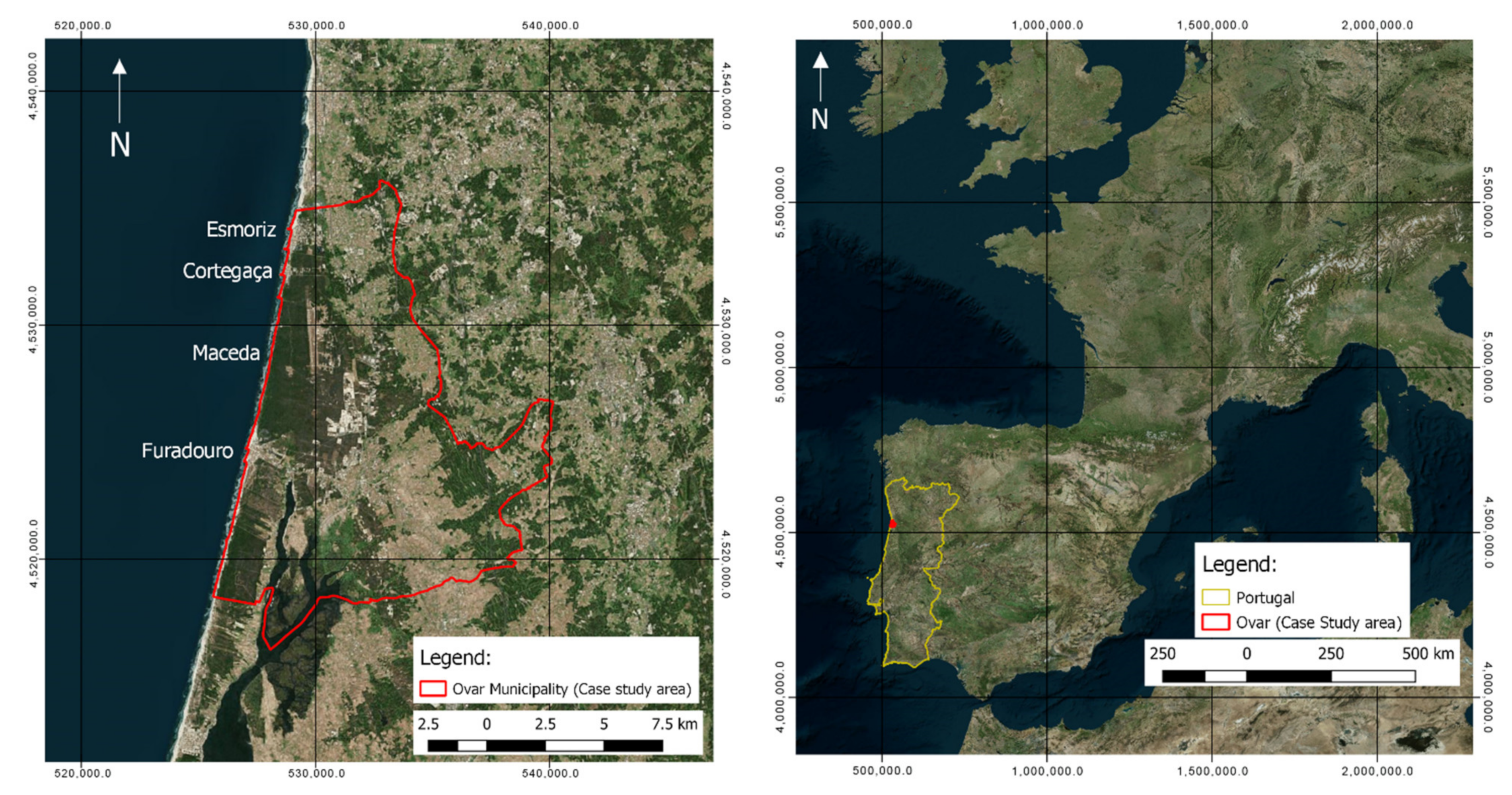
:1. Introduction
INCCA Project
2. Materials and Methods
- 1st Participatory Workshop—“Strategies, Costs and Benefits”;
- 2nd Participatory Workshop—“Scenarios for the Territory”;
- 3rd Participatory Workshop—“Adaptation Pathways”.
2.1. Participatory Workshop: Strategies, Costs, and Benefits
2.2. Participatory Workshop: Scenarios for the Territory
- “From the Silver Coast to the Stone Coast”, a scenario focused on heavy engineered hazard mitigation measures, such as groynes, breakwaters. and seawalls, that prioritized the protection of the communities at the cost of negative impacts to landscapes and local beaches;
- “InOvar, accepting the change”, a scenario focused on the adaptation of the populations to the changing coast, trying to find new ways to use the land instead of trying to negate or oppose these changes;
- “United we keep the coast and improve the beach”, a scenario that envisioned the maintenance of the sandy beaches for recreational use at any cost, placing emphasis on the value of these areas from an economic perspective.
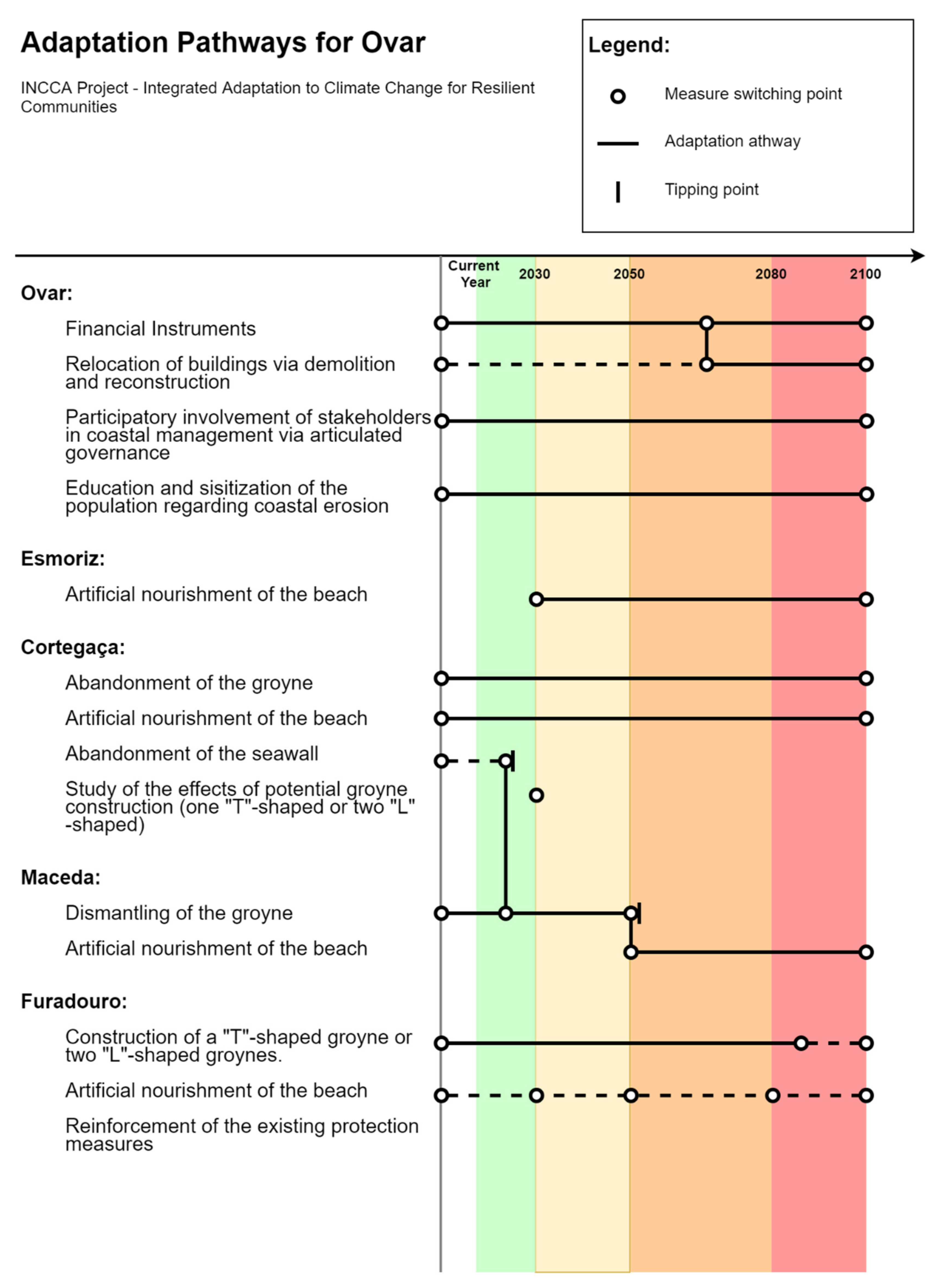
2.3. Participatory Workshop: Adaptation Pathways
- Section 1: Esmoriz-Cortegaça;
- Section 2: Cortegaça-Maceda;
- Section 3: Maceda-Furadouro.
2.4. Interested Parties—Stakeholders
3. Results
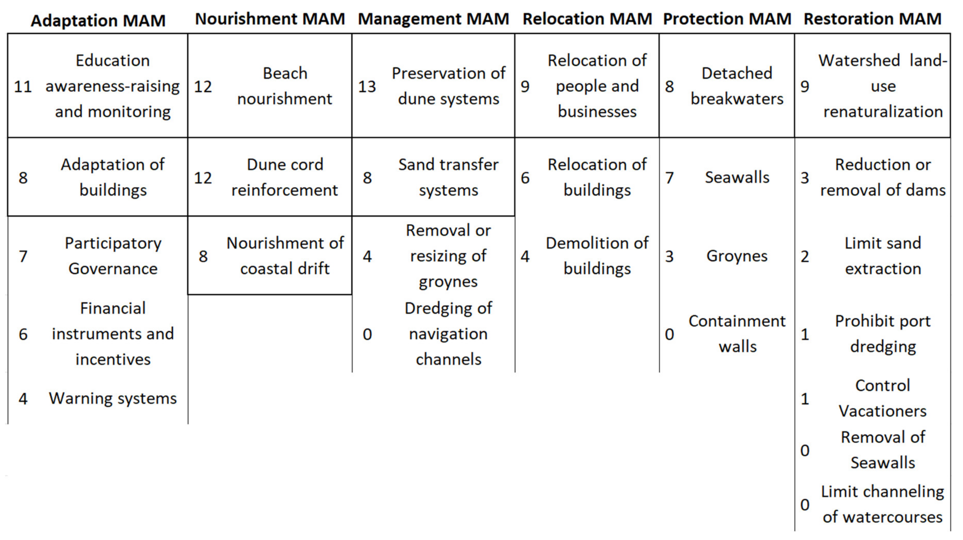
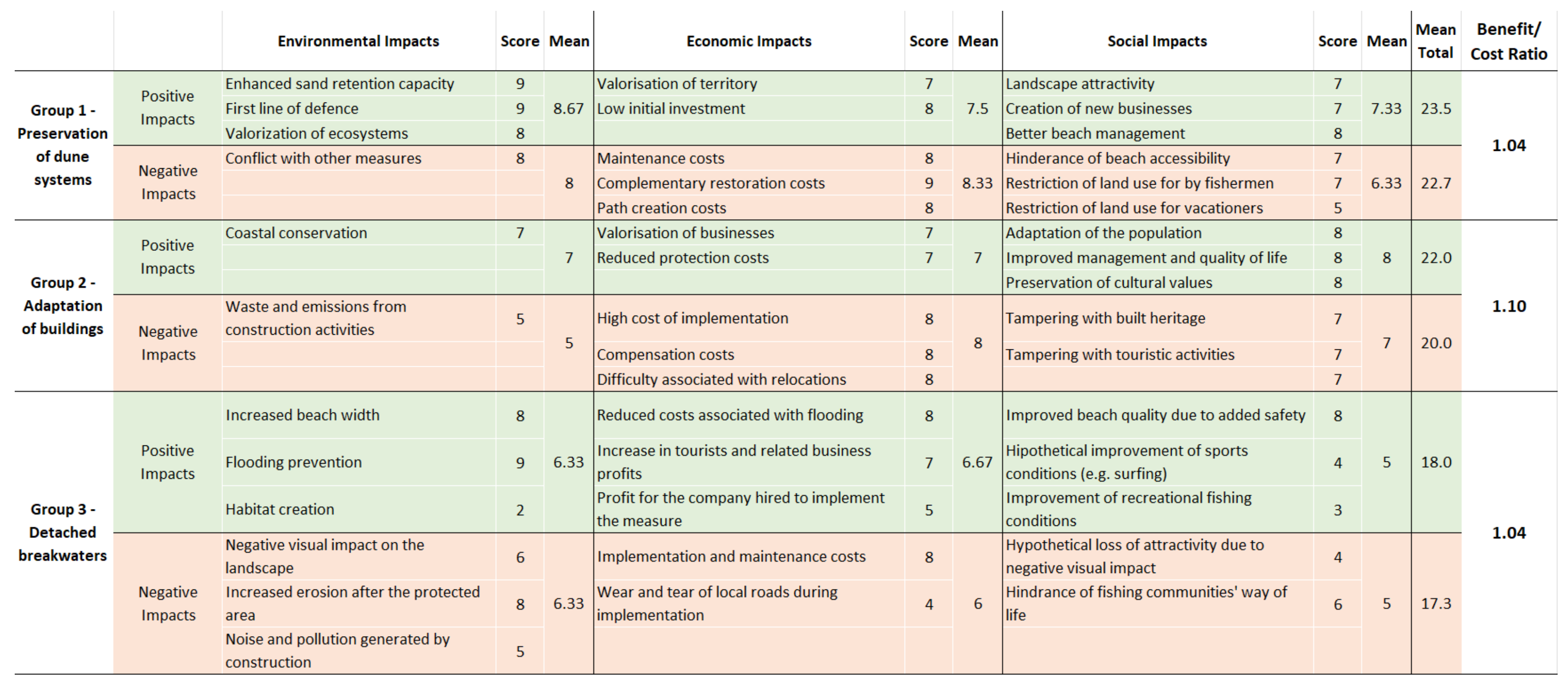
3.1. Participatory Workshop: Strategies, Costs and Benefits
3.2. Participatory Workshop: Scenarios for the Territory
- Avoid the loss of beach areas and urban territory by adding sediment via artificial nourishment as opposed to heavy protection measures;
- Gradual relocation of communities (housing, commerce and leisure) that are currently in danger and that will remain so in the coming years, as expressed by modelling simulations;
- Maintain the existing coastal defense works and consider the possibility of adding a detached breakwater to the Furadouro area;
- Combine engineering protection measures with artificial sand nourishment in key areas, namely the urban fronts of Esmoriz, Cortegaça and Furadouro;
- Renaturalize the areas left vacant by the relocation of the communities.
3.3. Participatory Workshop: Adaptation Pathways
4. Discussion
5. Conclusions and Final Thoughts
- Stakeholders residing or acting in areas affected by issues such as coastal erosion are passionate about their region and are willing to engage in participatory events designed to discuss future management plans and alternatives to help tackle these issues.
- Despite the belief that the public mistrusts the decision-making organs, all groups including administration, private and public sectors, as well as general citizens, can work together in these events if managed correctly. Not only that, but they also place trust in the experts and academics providing transparent information and mediating the process.
- Stakeholders prefer “soft” measures to mitigate and/or adapt to coastal erosion and related issues, placing emphasis on beach nourishment actions to combat the sediment deficit and on alternative governance and financing measures which they believe are simple and inexpensive to adopt, with benefits that can be visible in the long term. The tendency is, thus, to avoid using the “hard” engineered protection measures (e.g., groynes, seawalls) that were prevalent in the traditional approach used in decades past.
- The stakeholders hold the firm belief that their coast is valuable and must be maintained. They are willing to invest in arguably expensive continuous nourishment solutions in order to keep the beaches attractive and generating revenue, but also accept that some concessions must be made and that some level of shoreline change is inevitable. Above all, they unanimously agree that the communities must be protected, opting to keep most defensive structures where they prove effective but also proposing adaptation strategies to reduce exposure and risk to the rising sea level.
Author Contributions
Funding
Institutional Review Board Statement
Informed Consent Statement
Data Availability Statement
Conflicts of Interest
References
- Ahmed, A.; Drake, F.; Nawaz, R.; Woulds, C. Where is the coast? Monitoring coastal land dynamics in Bangladesh: An integrated management approach using GIS and remote sensing techniques. Ocean Coast. Manag. 2018, 151, 10–24. [Google Scholar] [CrossRef]
- Amani, M.; Ghorbanian, A.; Asgarimehr, M.; Yekkehkhany, B.; Moghimi, A.; Jin, S.; Naboureh, A.; Mohseni, F.; Mahdavi, S.; Layegh, N.F. Remote Sensing Systems for Ocean: A Review (Part 1: Passive Systems). IEEE J. Sel. Top. Appl. Earth Obs. Remote Sens. 2022, 15, 210–234. [Google Scholar] [CrossRef]
- Martínez, M.; Intralawan, A.; Vázquez, G.; Pérez-Maqueo, O.; Sutton, P.; Landgrave, R. The coasts of our world: Ecological, economic and social importance. Ecol. Econ. 2007, 63, 254–272. [Google Scholar] [CrossRef]
- Maes, J.; Teller, A.; Erhard, M.; Liquete, C.; Braat, L.; Berry, P.; Egoh, B.; Puydarrieux, P.; Fiorina, C.; Santos, F.; et al. An Analytical Framework for Ecosystem Assessments under Action 5 of the EU Biodiversity Strategy to 2020; European Union: Luxembourg, 2013. [Google Scholar]
- Bio, A.; Gonçalves, J.A.; Iglesias, I.; Granja, H.; Pinho, J.; Bastos, L. Linking Short- to Medium-Term Beach Dune Dynamics to Local Features under Wave and Wind Actions: A Northern Portuguese Case Study. Appl. Sci. 2022, 12, 4365. [Google Scholar] [CrossRef]
- Fabbri, P. (Ed.) Recreational Uses of Coastal Areas: A Research Project of the Commission on the Coastal Environment, International Geographical Union, 12th ed.; Springer: Dordrecht, The Netherlands, 1990. [Google Scholar]
- Rizzo, A.; Anfuso, G. Coastal Dynamic and Evolution: Case Studies from Different Sites around the World. Water 2020, 12, 2829. [Google Scholar] [CrossRef]
- McGranahan, G.; Balk, D.; Anderson, B. The rising tide: Assessing the risks of climate change and human settlements in low elevation coastal zones. Environ. Urban. 2007, 19, 17–37. [Google Scholar] [CrossRef]
- Neumann, B.; Vafeidis, A.T.; Zimmermann, J.; Nicholls, R.J. Future coastal population growth and exposure to sea-level rise and coastal flooding-a global assessment. PLoS ONE 2015, 10, e0118571. [Google Scholar] [CrossRef] [Green Version]
- Zhang, K.; Douglas, B.C.; Leatherman, S.P. Global Warming and Coastal Erosion. Clim. Chang. 2004, 64, 41–58. [Google Scholar] [CrossRef]
- Roebeling, P.C.; Coelho, C.D.; Reis, E.M. Coastal erosion and coastal defense interventions: A cost-benefit analysis. J. Coast. Res. 2011, 1415–1419. Available online: http://www.jstor.org/stable/26482408 (accessed on 1 November 2022).
- European Environment Agency. The Changing Faces of Europe’s Coastal Areas; European Environment Agency: Luxembourg, 2006; Volume 6. [Google Scholar]
- Ryan, E.; Owen, S.; Lawrence, J.; Glavovic, B.; Robichaux, L.; Dickson, M.; Kench, P.; Schneider, P.; Bell, R.; Blackett, P. Formulating a 100-year strategy for managing coastal hazard risk in a changing climate: Lessons learned from Hawke’s Bay, New Zealand. Environ. Sci. Policy 2022, 127, 1–11. [Google Scholar] [CrossRef]
- Veloso-Gomes, F.; Taveira-Pinto, F.; Das Neves, L.; Barbosa, J.P.; Coelho, C. Erosion risk levels at the NW Portuguese coast: The Douro mouth-Cape Mondego stretch. J. Coast. Conserv. 2004, 10, 43–52. [Google Scholar] [CrossRef]
- Bell, R.G.; Paulik, R.; Wadwha, S. National and Regional Risk Exposure in Low-Lying Coastal Areas; National Institute of Water & Atmospheric Research Ltd.: Hamilton, ON, Canada, 2015. [Google Scholar]
- Oppenheimer, M.; Glavovic, B.C.; Hinkel, J.; van de Wal, R.; Magnan, A.K.; Abd-Elgawad, A.; Cai, R.; Cifuentes-Jara, M.; DeConto, R.M.; Ghosh, T.; et al. Sea Level Rise and Implications for Low-Lying Islands, Coasts and Communities. In IPCC Special Report on the Ocean and Cryosphere in a Changing Climate; Pörtner, H.-O., Roberts, D.C., Masson-Delmotte, V., Zhai, P., Tignor, M., Poloczanska, E., Mintenbeck, K., Alegría, A., Nicolai, M., Okem, A., et al., Eds.; Cambridge University Press: Geneva, Switzerland, 2022; pp. 321–446. [Google Scholar]
- Alves, F.L.; Coelho, C.; Coelho, C.D.; Pinto, P. Modelling coastal vulnerabilities-Tool for decision support system at inter-municipality level. J. Coast. Res. 2011, 966–970. Available online: http://www.jstor.org/stable/26482317 (accessed on 1 November 2022).
- Alves, F.L.; da Silva, C.P.; Pinto, P. The assessment of the Coastal Zone development at a regional level-The case study of Portugal Central area. J. Coast. Res. 2007, 50, 72–76. [Google Scholar]
- Alves, F.L.; de Sousa, L.P.; Esteves, T.; Oliveira, E.R.; Antunes, I.C.; Fernandes, M.D.L.; Carvalho, L.; Barroso, S.; Pereira, M. Trend Change(s) in Coastal Management Plans: The integration of short and medium term perspectives in the spatial planning process. J. Coast. Res. 2014, 70, 437–442. [Google Scholar] [CrossRef]
- RIKZ-National Institute of Coastal and Marine Management of the Netherlands. Service contract B4-3301/2001/329175/MAR/B3 Coastal Erosion Evaluation of the needs for Action Directorate General Environment European Commission, a Guide to Coastal Erosion Management Practices in Europe; RIKZ-National Institute of Coastal and Marine Management of the Netherlands: Hague, The Netherlands, 2004. [Google Scholar]
- Carrero, R.; Navas, F.; Malvárez, G.; Cáceres, F. Participative future scenarios for integrated coastal zone management. J. Coast. Res. 2013, 65, 898–903. [Google Scholar] [CrossRef]
- Esteves, L.S. Is managed realignment a sustainable long-term coastal management approach? J. Coast. Res. 2013, 65, 933–938. [Google Scholar] [CrossRef]
- Brown, S.; Nicholls, R.J.; Goodwin, P.; Haigh, I.D.; Lincke, D.; Vafeidis, A.T.; Hinkel, J. Quantifying Land and People Exposed to Sea-Level Rise with No Mitigation and 1.5 °C and 2.0 °C Rise in Global Temperatures to Year 2300. Earth’s Futur. 2018, 6, 583–600. [Google Scholar] [CrossRef]
- Stephens, S.A.; Bell, R.G.; Lawrence, J. Developing signals to trigger adaptation to sea-level rise. Environ. Res. Lett. 2018, 13, 104004. [Google Scholar] [CrossRef]
- Ferreira, A.M.; Coelho, C.; Narra, P. Coastal erosion risk assessment to discuss mitigation strategies: Barra-Vagueira, Portugal. Nat. Hazards 2020, 105, 1069–1107. [Google Scholar] [CrossRef]
- Granja, H.; Bastos, L.; Pinho, J.; Gonçalves, J.; Henriques, R.; Bio, A.; Magalhães, A. Small harbours risks: Lowering for fishery and increasing erosion. Case Portinho Da Aguda (Nw Port.) 2011, 09003. [Google Scholar] [CrossRef] [Green Version]
- Vieira, B.F.V.; Pinho, J.L.S.; Barros, J.A.O.; Carmo, J.S.A.D. Hydrodynamics and Morphodynamics Performance Assessment of Three Coastal Protection Structures. J. Mar. Sci. Eng. 2020, 8, 175. [Google Scholar] [CrossRef] [Green Version]
- Lima, M.; Coelho, C.; Veloso-Gomes, F.; Roebeling, P. An integrated physical and cost-benefit approach to assess groins as a coastal erosion mitigation strategy. Coast. Eng. 2020, 156, 103614. [Google Scholar] [CrossRef]
- Rangel-Buitrago, N.; Williams, A.; Anfuso, G. Hard protection structures as a principal coastal erosion management strategy along the Caribbean coast of Colombia. A chronicle of pitfalls. Ocean Coast. Manag. 2018, 156, 58–75. [Google Scholar] [CrossRef]
- Semeoshenkova, V.; Newton, A. Overview of erosion and beach quality issues in three Southern European countries: Portugal, Spain and Italy. Ocean Coast. Manag. 2015, 118, 12–21. [Google Scholar] [CrossRef]
- Marinho, B.; Coelho, C.; Hanson, H.; Tussupova, K. Coastal management in Portugal: Practices for reflection and learning. Ocean Coast. Manag. 2019, 181, 104874. [Google Scholar] [CrossRef]
- Coelho, C.; Narra, P.; Marinho, B.; Lima, M. Coastal Management Software to Support the Decision-Makers to Mitigate Coastal Erosion. J. Mar. Sci. Eng. 2020, 8, 37. [Google Scholar] [CrossRef] [Green Version]
- Ramm, T.D.; Watson, C.; White, C.J. Strategic adaptation pathway planning to manage sea-level rise and changing coastal flood risk. Environ. Sci. Policy 2018, 87, 92–101. [Google Scholar] [CrossRef] [Green Version]
- Hulet, C.; Field, P.; Curti, J. Why public engagement is necessary to enhance local readiness for climate adaptation. In Managing Climate Risks in Coastal Communities: Strategies for Engagement, Readiness and Adaptation; Susskind, L., Rumore, D., Hulet, C., Field, P., Eds.; Anthem Press: London, UK, 2015; pp. 59–84. [Google Scholar]
- Rouse, H.; Blackett, P.; Hume, T.; Smith, E.; Dahm, J. Engaging with Communities on Coastal Adaptation to Climate Change: Whitianga Experience, an Internal Report as Part of the CACC Project; National Institute of Water & Atmospheric Research Ltd.: Hamilton, ON, Canada, 2011. [Google Scholar]
- Schmidt, L.; Prista, P.; Saraiva, T.; O’Riordan, T.; Gomes, C. Adapting governance for coastal change in Portugal. Land Use Policy 2013, 31, 314–325. [Google Scholar] [CrossRef]
- Schmidt, L.; Gomes, C.; Guerreiro, S.; O’Riordan, T. Are we all on the same boat? The challenge of adaptation facing Portuguese coastal communities: Risk perception, trust-building and genuine participation. Land Use Policy 2014, 38, 355–365. [Google Scholar] [CrossRef]
- Huitema, D.; Mostert, E.; Egas, W.; Moellenkamp, S.; Pahl-Wostl, C.; Yalçin, R. Adaptive Water Governance: Assessing the Institutional Prescriptions of Adaptive (Co-)Management from a Governance Perspective and Defining a Research Agenda. Ecol. Soc. 2009, 14, 26. [Google Scholar] [CrossRef]
- Ballinger, R.; Pickaver, A.; Lymbery, G.; Ferreria, M. An evaluation of the implementation of the European ICZM principles. Ocean Coast. Manag. 2010, 53, 738–749. [Google Scholar] [CrossRef]
- Dean, A.J.; Fielding, K.S.; Wilson, K.A. Building community support for coastal management—What types of messages are most effective? Environ. Sci. Policy 2018, 92, 161–169. [Google Scholar] [CrossRef]
- 2009/89/EC, Council Decision of 4 December 2008 on the Signing, On Behalf of the European Community, of the Protocol on Integrated Coastal Zone Management in the Mediterranean to the Convention for the Protection of the Marine Environment and the Coastal Region of th. Off. J. Eur. Union 2009, L34, 17–18. Available online: http://eur-lex.europa.eu/legal-content/EN/TXT/?uri=OJ:JOL_2009_034_R_0017_01 (accessed on 28 September 2022).
- Anderson, C.C.; Renaud, F.G.; Hanscomb, S.; Munro, K.E.; Gonzalez-Ollauri, A.; Thomson, C.S.; Pouta, E.; Soini, K.; Loupis, M.; Panga, D.; et al. Public Acceptance of Nature-Based Solutions for Natural Hazard Risk Reduction: Survey Findings from Three Study Sites in Europe. Front. Environ. Sci. 2021, 9, 678938. [Google Scholar] [CrossRef]
- Begg, C.; Callsen, I.; Kuhlicke, C.; Kelman, I. The role of local stakeholder participation in flood defence decisions in the United Kingdom and Germany. J. Flood Risk Manag. 2017, 11, 180–190. [Google Scholar] [CrossRef] [Green Version]
- Kuhlicke, C.; Seebauer, S.; Hudson, P.; Begg, C.; Bubeck, P.; Dittmer, C.; Grothmann, T.; Heidenreich, A.; Kreibich, H.; Lorenz, D.F.; et al. The behavioral turn in flood risk management, its assumptions and potential implications. WIREs Water 2020, 7, e1448. [Google Scholar] [CrossRef] [Green Version]
- Zingraff-Hamed, A.; Hüesker, F.; Lupp, G.; Begg, C.; Huang, J.; Oen, A.; Vojinovic, Z.; Kuhlicke, C.; Pauleit, S. Stakeholder Mapping to Co-Create Nature-Based Solutions: Who Is on Board? Sustainability 2020, 12, 8625. [Google Scholar] [CrossRef]
- Dribek, A.; Voltaire, L. Contingent valuation analysis of willingness to pay for beach erosion control through the stabiplage technique: A study in Djerba (Tunisia). Mar. Policy 2017, 86, 17–23. [Google Scholar] [CrossRef]
- Farrugia, M.T. Public perceptions on coastal erosion in the Maltese Islands: A case study of St George’s Bay (St Julians) and Pretty Bay (Birżebbuġa). Nat. Hazards 2017, 86, 587–604. [Google Scholar] [CrossRef]
- Silver, C. Jakarta’s present and future of flood risk management. In Urban Flood Risk Management; Routledge: London, UK, 2021; pp. 162–191. [Google Scholar] [CrossRef]
- Fitton, J.M.; Addo, K.A.; Jayson-Quashigah, P.-N.; Nagy, G.J.; Gutiérrez, O.; Panario, D.; Carro, I.; Seijo, L.; Segura, C.; Verocai, J.E.; et al. Challenges to climate change adaptation in coastal small towns: Examples from Ghana, Uruguay, Finland, Denmark, and Alaska. Ocean Coast. Manag. 2021, 212, 105787. [Google Scholar] [CrossRef]
- McKinley, E.; Crowe, P.; Stori, F.; Ballinger, R.; Brew, T.; Blacklaw-Jones, L.; Cameron-Smith, A.; Crowley, S.; Cocco, C.; O’Mahony, C.; et al. ‘Going digital’-Lessons for future coastal community engagement and climate change adaptation. Ocean Coast. Manag. 2021, 208, 105629. [Google Scholar] [CrossRef]
- Areia, N.; Tavares, A.; Mendes, J. Environment Actors Confronting a Post Climate-Related Disaster Scenario: A Feasibility Study of an Action-Based Intervention Aiming to Promote Climate Action. Int. J. Environ. Res. Public Health 2021, 18, 5949. [Google Scholar] [CrossRef]
- Campos, I.; Vizinho, A.; Coelho, C.; Alves, F.; Truninger, M.; Pereira, C.; Santos, F.D.; Lopes, G.P. Participation, scenarios and pathways in long-term planning for climate change adaptation. Plan. Theory Prcatice 2016, 17, 537–556. [Google Scholar] [CrossRef]
- Fabricius, C.; Koch, E.; Magome, H.; Turner, S. Rights, resources and rural development: Community-based natural resource management in Southern Africa. In Rights Resources and Rural Development: Community-Based Natural Resource Management in Southern Africa; Routledge: London, UK, 2013; pp. 1–288. [Google Scholar] [CrossRef]
- Amaru, S.; Chhetri, N.B. Climate adaptation: Institutional response to environmental constraints, and the need for increased flexibility, participation, and integration of approaches. Appl. Geogr. 2013, 39, 128–139. [Google Scholar] [CrossRef]
- McNiff, J. Action Research: Principles and Practice, 3rd ed.; Routledge: London, UK, 2013. [Google Scholar]
- Wittmayer, J.M.; Schäpke, N. Action, research and participation: Roles of researchers in sustainability transitions. Sustain. Sci. 2014, 9, 483–496. [Google Scholar] [CrossRef]
- Vizinho, A.; Campos, I.; Coelho, C.; Pereira, C.; Roebeling, P.; Alves, F.; Rocha, J.; Alves, M.F.; Santos, F.D.; Penha-Lopes, G. SWAP-Participatory planning of coastal adaptation to climate change. J. Integr. Coast. Zone Manag. 2017, 17, 99–116. [Google Scholar] [CrossRef] [Green Version]
- Zandvoort, M.; Campos, I.S.; Vizinho, A.; Penha-Lopes, G.; Lorencová, E.K.; van der Brugge, R.; van der Vlist, M.J.; Brink, A.V.D.; Jeuken, A.B. Adaptation pathways in planning for uncertain climate change: Applications in Portugal, the Czech Republic and the Netherlands. Environ. Sci. Policy 2017, 78, 18–26. [Google Scholar] [CrossRef]
- Penha-Lopes, G. Change in the way we live and plan the coast: Stakeholders discussions on future scenarios and adaptation strategies. J. Coast. Res. 2013, 65, 1033–1038. [Google Scholar] [CrossRef] [Green Version]
- Lima, M. Numerical Tool for Analysis of the Impact of Coastal Defence Interventions on Shoreline Evolution: Costs and Benefits. Ph.D. Thesis, University of Aveiro, Aveiro, Portugal, 2018. [Google Scholar]
- Lima, M.; Alves, F.; Marto, M.; Coelho, C. Medidas de mitigação e adaptação à erosão costeira e aos efeitos das alterações climáticas. J. Water Resour. 2021, 42, 61–70. [Google Scholar] [CrossRef]
- Lima, M.; Coelho, C.; Alves, F.; Marto, M. Base de Dados #1–Medidas de Mitigação e Adaptação à Erosão Costeira e às Alterações Climáticas, Projeto INCCA–Adaptação Integrada às Alterações Climáticas para Comunidades Resilientes (POCI-01-0145-FEDER-030842), Universidade de Aveiro. 2021. Available online: http://incca.web.ua.pt/index.php/manual/ (accessed on 28 September 2022).
- Lima, M.; Coelho, C.; Alves, F.; Marto, M. Base de Dados #2–Medidas de Mitigação e Adaptação à Erosão Costeira e às Alterações Climáticas, Projeto INCCA–Adaptação Integrada às Alterações Climáticas para Comunidades Resilientes (POCI-01-0145-FEDER-030842), Universidade de Aveiro. 2021. Available online: http://incca.web.ua.pt/index.php/base-de-dados-2/ (accessed on 28 September 2022).
- Lima, M.; Coelho, C.; Alves, F.; Marto, M. Base de Dados #3–Medidas de Mitigação e Adaptação à Erosão Costeira e às Alterações Climáticas, Projeto INCCA–Adaptação Integrada às Alterações Climáticas para Comunidades Resilientes (POCI-01-0145-FEDER-030842), Universidade de Aveiro. 2021. Available online: http://incca.web.ua.pt/index.php/base-de-dados-3/ (accessed on 28 September 2022).
- Alves, F. Technical Report of the 1st Participatory Workshop of the INCCA Project: Analysis, Economics of Mitigation and Adaptation Measures to Coastal Erosion in the Municipality of Ovar; FCUL: Lisbon, Portugal, 2021. [Google Scholar]
- Rato, D.; Alves, F.; Vizinho, A.; Lima, M.; Coelho, C. Technical Report of the 2nd Participatory Workshop of the INCCA Project: Analysis of Scenarios and Future Visions for Coastal Management in the Ovar municipality; FCUL: Lisbon, Portugal, 2021. [Google Scholar]
- Andersen, I.-E.; Jaeger, B. Scenario workshops and consensus conferences: Towards more democratic decision-making. Sci. Public Policy 1999, 26, 331–340. [Google Scholar] [CrossRef]


| Sector | Organization, Group or Individual |
|---|---|
| Academia | University of Lisbon |
| University of Aveiro | |
| University of Minho | |
| University of Porto | |
| National Institutions | National Laboratory for Civil Engineering (LNEC) |
| Portuguese Environment Agency (APA) | |
| Polis Litoral Ria de Aveiro | |
| Public Services | Humanitarian Association of Volunteer Firefighters of Ovar |
| Local Administration | Municipal Council of Ovar |
| Parish Council of Cortegaça | |
| Parish Council of Esmoriz | |
| Parish Council of Maceda | |
| Private Institutions | Centre for Studies and Urban and Regional Development (CEDRU) |
| Local Businesses | Barrinha Surf School (BSS) |
| Local Media | OvarNews |
| Non-Governmental Organization | Clube de Campismo do Porto (CCP) |
| Youth Association Amigos do Cáster | |
| Others | Interested locals |
| Group 1 | Group 2 | Group 3 | ||
|---|---|---|---|---|
| 1 | Financial instruments and incentives | Participatory Governance | Financial instruments and incentives | Legend: |
| 2 | Nourishment of coastal drift | Adaptation of buildings | Nourishment of coastal drift | Adaptation MAM |
| 3 | Beach nourishment | Beach nourishment | Beach nourishment | Nourishment MAM |
| 4 | Reduction or removal of dams | Seawalls | Preservation of dune systems | Management MAM |
| 5 | Preservation of dune systems | Education awareness-raising and monitoring | Dune cord reinforcement | Protection MAM |
| 6 | Dune cord reinforcement | Relocation of people and businesses | Education awareness-raising and monitoring | Restoration MAM |
| 7 | Detached breakwaters | Financial instruments and incentives | Detached breakwaters | Relocation MAM |
| 8 | Groynes | Preservation of dune systems | Removal or resizing of groynes | |
| 9 | Education awareness-raising and monitoring | Dune cord reinforcement | Adaptation of buildings | |
| 10 | Watershed land-use renaturalization | Sand transfer systems | Relocation of buildings |
| MAM | Environmental Impact (20%) | Efficacy (20%) | Level of Certainty (20%) | Cost/Investment (20%) | Urgency (20%) | Average Total | Weighted Total |
|---|---|---|---|---|---|---|---|
| Financial instruments and incentives | 5 | 7 | 4 | 9 | 8 | 6.6 | 6.6 |
| Beach nourishment | 7 | 6 | 5 | 6 | 8 | 6.0 | 6.0 |
| MAM | Efficacy (40%) | Cost/Investment (20%) | Popular Acceptance (10%) | Environmental Impact (20%) | Temporality (10%) | Average Total | Weighted Total |
|---|---|---|---|---|---|---|---|
| Participatory Governance | 7 | 8 | 8 | 5 | 8 | 7.2 | 7.0 |
| Adaptation of buildings | 7 | 2 | 6 | 3 | 7 | 5.0 | 5.1 |
| Dune cord reinforcement | 6 | 3 | 7 | 8 | 1 | 5.0 | 5.4 |
| MAM | Efficacy (30%) | Cost/Investment (25%) | Environmental Impact (20%) | Urgency (15%) | Popular Acceptance (10%) | Average Total | Weighted Total |
|---|---|---|---|---|---|---|---|
| Nourishment of coastal drift | 8 | 4 | 7 | 9 | 7 | 7.0 | 6.9 |
| Preservation of dune systems | 6 | 7 | 8 | 9 | 7 | 7.4 | 7.2 |
| Education awareness-raising and monitoring | 6 | 5 | 8 | 8 | 6 | 6.6 | 6.5 |
| Narrative | Group 1 | Group 2 | Group 3 | Group 4 |
|---|---|---|---|---|
| Scenario 1 “From the Silver Coast to the Stone Coast” | Accepted in combination with Scenario 3 | Accepted in combination with Scenario 3 | Rejected scenario | Integration of the three scenarios |
| Scenario 2 “InOvar, accept change” | Rejected scenario | Rejected scenario | Rejected Scenario | |
| Scenario 3 “United we keep the coast and improve the beach” | Accepted in combination with Scenario 1 | Accepted in combination with Scenario 1 | Preferred scenario |
Publisher’s Note: MDPI stays neutral with regard to jurisdictional claims in published maps and institutional affiliations. |
© 2022 by the authors. Licensee MDPI, Basel, Switzerland. This article is an open access article distributed under the terms and conditions of the Creative Commons Attribution (CC BY) license (https://creativecommons.org/licenses/by/4.0/).
Share and Cite
Matos, F.A.; Alves, F.; Coelho, C.; Lima, M.; Vizinho, A. Participatory Approach to Build Up a Municipal Strategy for Coastal Erosion Mitigation and Adaptation to Climate Change. J. Mar. Sci. Eng. 2022, 10, 1718. https://doi.org/10.3390/jmse10111718
Matos FA, Alves F, Coelho C, Lima M, Vizinho A. Participatory Approach to Build Up a Municipal Strategy for Coastal Erosion Mitigation and Adaptation to Climate Change. Journal of Marine Science and Engineering. 2022; 10(11):1718. https://doi.org/10.3390/jmse10111718
Chicago/Turabian StyleMatos, Fábio André, Filipe Alves, Carlos Coelho, Márcia Lima, and André Vizinho. 2022. "Participatory Approach to Build Up a Municipal Strategy for Coastal Erosion Mitigation and Adaptation to Climate Change" Journal of Marine Science and Engineering 10, no. 11: 1718. https://doi.org/10.3390/jmse10111718