Article

Evaluation of Land Suitability for Olive (Olea europaea L.) Cultivation Using the Random Forest Algorithm

Department of Geomatics Engineering, Faculty of Engineering, Artvin Coruh University, Artvin 08000, Turkey
*
Author to whom correspondence should be addressed.
Agriculture 2023, 13(6), 1208; https://doi.org/10.3390/agriculture13061208
Submission received: 19 April 2023 / Revised: 23 May 2023 / Accepted: 6 June 2023 / Published: 7 June 2023

Abstract

:
Many large dams built on the Çoruh River have resulted in the inundation of olive groves in Artvin Province, Turkey. This research sets out to identify suitable locations for olive cultivation in Artvin using the random forest (RF) algorithm. A total of 575 plots currently listed in the Farmer Registration System, where olive cultivation is practiced, were used as inventory data in the training and validation of the RF model. In order to determine the areas where olive cultivation can be carried out, a land suitability map was created by taking into account 10 parameters including the average annual temperature, average annual precipitation, slope, aspect, land use capability class, land use capability sub-class, soil depth, other soil properties, solar radiation, and land cover. According to this map, an area of 53,994.57 hectares was detected as suitable for olive production within the study region. To validate the created model, the receiver operating characteristic (ROC) curve and the area under the ROC curve (AUC) were utilized. As a result, the AUC value was determined to be 0.978, indicating that the RF method may be successfully used in determining suitable lands for olive cultivation in particular, as well as crop-based land suitability research in general.

1. Introduction

Olive (Olea europaea L.), one of the oldest cultivated plants in the world and characterizing the Mediterranean climate, has played an essential role in both the nutrition and economy of societies throughout history [1]. Olive, a plant species with high economic value, is a plant that cannot be grown ecologically and economically everywhere, spreads between 30° and 45° latitudes depending on the Mediterranean climate and grows almost entirely in countries with a coast to the Mediterranean [2,3,4,5]. Unlike the climate, the olive is not very picky about soil as it instead prefers soils that are calcareous sandy, deep, and rich in nutrients [6]. In terms of soil properties, Alvarez et al. [7] stated that soil texture classes in organic and natural olive groves in the south of Spain are loamy or sandy loam, while Doğan and Gülser [8] stated that soil texture classes in olive groves in İzmir (Turkey) are generally coarse or medium. According to Tombesi and Tombesi [9], olives grow best on soil textures that have a balance of sand, silt, and clay.
Olive was the first agricultural crop to be legally supported by law in Turkey [3]. Due to the ecological conditions of olive fields, it is observed that it spreads mainly in the Mediterranean, Aegean, and Marmara coastal areas of Turkey as well as in parts of Southeastern Anatolia, the Black Sea Region, and in the interior parts with favorable climatic conditions.
Olive cultivation is conducted in approximately 3% of the total agricultural land in Turkey [3]. According to reports, this area has grown to 880,000 hectares as of 2021, and olive production increased by 71.2% in 2022 compared to 2021 [10]. Hantekin [3] states that a large part of this increase in olive fields is due to the conversion of forests and scrubland. On the other hand, it is a well-known fact that olive fields in Turkey are under various threats such as secondary residences [2,11], mining and tourism activities [12], and large investment projects (e.g., dam constructions).
Shadeed et al. [13] emphasized that the need for food will increase by 70% in 2050 due to the rapidly increasing global population, and it is important to provide sustainability in agriculture to the point of ensuring food security for the increasing population and planting each crop in the most suitable lands. To meet the increasing food need, it is very important that land use is compatible with the Sustainable Development Goals and that sustainability in agriculture can be achieved. In this context, land suitability analysis and determination of arable areas have been two of the preferred practices in ensuring global food security, which is one of the UN’s Sustainable Development Goals [1,11]. Land suitability analysis can be defined as a tool that requires the determination of the ecological needs of the crop for optimum use of the land and is used to determine the most suitable areas to shape future land use [4,13,14]. Land suitability evaluation is a process that requires the analysis and interpretation of biophysical, economic, and socio-cultural factors such as soil properties, land use, climatic conditions, and topography [13,15].
It has been noticed that there are numerous studies on land suitability analyses in the literature. Some of these studies [16,17,18,19] aimed to determine suitable areas for agriculture, while others [20,21,22,23,24,25,26,27] aimed to determine suitable areas for the cultivation of certain agricultural crops such as citrus, rice, tobacco, tea, hazelnut, and grape. When the aforementioned studies are examined, it can be seen that there are few studies carried out to determine suitable areas for olive cultivation, and these studies mostly use multi-criteria decision analysis (MCDA) methods and geographic information systems (GIS). For example, Bilgilioğlu [5] determined suitable areas for olive cultivation by using GIS and the analytic hierarchy process (AHP) method in his study in Mersin (Turkey), while Tuğaç and Sefer [4] determined suitable areas for olive cultivation in the whole of Turkey (on a national scale) by applying GIS and the AHP method. Furthermore, while Shadeed et al. [13] produced a land suitability map by performing a land suitability evaluation for olive cultivation using GIS and the AHP in the West Bank (Palestine), Elaalem [28] examined the land suitability for olive cultivation in a study conducted in the Jeffara Plain of Libya, in comparison with parametric and fuzzy MCDA methods. Shiri and Farbodi [29] also performed the land suitability assessment for olives using the simple restriction method and parametric method in Zanjan Province (Iran). Bienes et al. [30] handled the suitability of land for olive cultivation based on the soil and climate criteria in the Madrid region (Spain). Moreover, Guo et al. [31] evaluated the ecological suitability of olive trees in Sichuan Province (China) using fuzzy set and GIS methods.
On the other hand, it can be observed in the literature that machine learning (ML) algorithms are rarely used in land suitability analysis. ML and deep learning (DL) algorithms are generally used in studies carried out to determine areas where certain agricultural crops are cultivated (such as hazelnut orchards, wheat, or maize cultivation areas) from satellite images, to predict yields or to detect plant diseases [32,33,34,35]. However, in the study conducted by Taghizadeh-Mehrjardi et al. [36] in Iran, land suitability maps for barley and wheat were produced using random forest (RF) and support vector machine (SVM) learning algorithms. In the study by Xing et al. [25], a suitability evaluation model based on machine learning models was proposed for tea cultivation. In that study, in which many ML models were compared, suitable areas for tea cultivation were determined by using 12 parameters including climate, soil, land, and economy factors and the RF algorithm. In the literature, there are studies carried out to determine the distribution of olive trees in a particular region or to determine olive tree varieties using ML or DL algorithms [37,38,39,40]. However, to the best of our knowledge, no study has been performed to determine suitable areas for olive cultivation using ML algorithms. Therefore, this article fills an important gap in the literature as it is the first study to evaluate suitable areas for olive cultivation using ML algorithms.
Artvin Province, located in the Eastern Black Sea Region of Turkey, was chosen as the research area due to its favorable microclimates for olive cultivation, particularly in the Çoruh River Valley. However, several large dams constructed on the Çoruh River in recent years have resulted in the inundation of the city’s olive groves, necessitating the development of alternative olive-growing regions. Consequently, the goal of the current study was to identify suitable areas for olive cultivation utilizing the RF algorithm, which has been shown to have high prediction performance in various applications [25,37,41,42]. The scientific contributions of this study can be described as follows: (i) this study will be the first to assess suitable areas for olives using the RF algorithm, a strong and robust ML algorithm, (ii) with this study, alternative suitable areas to the olive areas inundated by the reservoir of several large dams will be determined, (iii) the outputs of this study will guide institutions such as the Artvin Provincial Directorate of Agriculture and Forestry in planning to expand olive fields throughout Artvin, and (iv) finally, this study will encourage new ML-based studies on the subject.

2. Materials and Methods

2.1. Study Area

Artvin Province, located in the northeast of the Black Sea Region, is one of the 36 provinces in Turkey where olive cultivation is carried out [6]. The micro-climatic conditions in Artvin and the Black Sea Region allow olive cultivation in the region [3]. Therefore, this study was conducted in the Merkez and Yusufeli districts, which are at the forefront of olive production in Artvin Province. The study area, which has a surface area of 3466 km2, is located between 40°34′8.4″ and 41°21′25.2″ north latitude and 41°9′32.4″ and 42°10′43.8″ east longitude (Figure 1).
In the study area, which covers the administrative borders of the two districts, there are 12 neighborhoods and 99 villages, and according to the data of the address-based population registration system in 2022, a total of 54,987 people live there [10]. The elevation of the research area, which includes highly difficult terrain, ranges from 125 to 3930 m. The average slope in the research region, where the slope runs from 0 to 548%, is 62%, and the slope is greater than 30% across 90% of the area [18].
Three large dams on the Çoruh River, which runs through the research region, named Deriner, Artvin, and Yusufeli, were completed in recent years, in 2012, 2015, and 2022, respectively. These dams have completely or partially inundated many settlements (58 villages and Yusufeli city center), as well as devastating fertile agricultural lands. It is projected that roughly 1633.40 hectares of agricultural land have been inundated as a result of these huge dams [43,44].
According to the activity reports of the Artvin Provincial Directorate of Agriculture and Forestry [45], the olive fields in Artvin were 424 hectares in total at the beginning of the 2000s, while this decreased to 86.1 hectares in 2021 (Figure 2). When Figure 2 is examined, the decreases in 2007, 2013, and 2017 are noticeable. The effect of the large dams mentioned above can be seen in this decrease in olive fields. In contrast, an increase of 5.5 hectares in olive fields in 2021 draws attention (Figure 2). It can be said that olive saplings produced by the Artvin Provincial Directorate of Agriculture and Forestry and distributed free of charge to the public were effective in this increase.
Considering Artvin Province in terms of the rate of olive production, it is seen that the production varies between 1425 tons and 2520 tons, although there are differences according to the years. In addition, in the 2021 activity report of the Artvin Provincial Directorate of Agriculture and Forestry, the presence of 33,652.2 hectares of unused agricultural land throughout the province draws attention and it is of significant importance to bring these areas into production.
Although there is a remarkable amount of land in the study area, the arable areas are quite limited especially in the Yusufeli district [18]. However, all kinds of fruits and vegetables, especially olives, rice, and grapes, can be grown in these limited areas [46]. Olive cultivation in the city is one of the main sources of income for small-scale farmers. It is seen that it is important to plant varieties suitable for ecology in the region where olive cultivation is carried out, and in this context, local olive species such as “Otur, Butko, and Sati” are preferred in the region [6,47].

2.2. Data Set

Examining the crop-based suitability of the land is a multidimensional process that requires many criteria to be considered and evaluated together. Biophysical factors, including climate, topography, and soil properties, are very important in determining the cultivation areas of agricultural crops and crop cultivation suitability and are widely used in such studies [25].
The parameters that can be used to identify potential areas suitable for olive cultivation in Artvin Province were determined with the help of the studies in the literature [4,5,13,31,48] and considering the local conditions of the study area. Accordingly, a total of 15 parameters including average annual temperature, average annual precipitation, average annual max. and min. temperatures, elevation, slope, aspect, great soil group (GSG), land use capability class (LUCC), land use capability sub-class (LUCS), soil depth, erosion degree, other soil properties (OSP), solar radiation, and land cover were used in the study. Some characteristics of the evaluation parameters used in this article are presented in Table 1.

2.2.1. Climatological Parameters

The climate is the most effective and essential factor in deciding where agricultural crops can be grown [3,4,13,37,49]. Climate has the power to affect the lives of all living beings, and there are specific climatic zones where some plant species such as olives can grow [50]. As a result, analyzing climate characteristics is critical in selecting possible sites appropriate for olive growing.
Olive finds the best-growing conditions in the Mediterranean climate, where the winters are mild and rainy and the summers are warm and dry [2,6,12]. Average annual temperatures in olive cultivation areas in Turkey vary between 14.9 °C and 18.5 °C [4,51]. While summer drought, which is the most basic feature of the Mediterranean climate, increases olive growth and quality [3], sufficient moisture in the soil in spring affects flower formation, grain set rate, and oil formation [3,4,47]. It is understood that low- or high-temperature values or weather events such as frost can negatively affect the growth and yield of olives [4], so it is important to consider the maximum and minimum temperatures in olive farming in addition to the average temperature [52].
Precipitation, like temperature, is a remarkable and effective component in olive production [1,13], and its seasonal distribution is as important as its volume. For all these reasons, average annual temperature, average annual maximum and minimum temperature, and average annual precipitation parameters were taken into account in this study. The information for the aforementioned parameters was gathered from monthly observation data collected between 2010 and 2022 by the Turkish State Meteorological Service at 23 meteorological stations inside and surrounding the study area. First, on a station basis, monthly data were transformed into yearly average data. Temperature and precipitation data acquired from meteorological stations are mapped using geostatistical approaches such as inverse distance weighted (IDW) and Kriging methods, according to the literature [5,50]. However, because the distance between stations is quite long and the elevation difference between stations is high due to topography, these interpolated maps do not provide accurate and reliable results. Therefore, after accounting for their association with elevation (a 54 mm increase in precipitation and a 0.5 °C drop in temperature with every 100 m of height increase), the temperature and precipitation data were lowered to the sea surface. Following this, the reduced values were carried to grid points with a resolution of 1 × 1 km and a specific elevation, and the average temperature (Figure 3a) and average total precipitation (Figure 3b) maps of the study area were obtained by interpolation (inverse distance weighted—IDW) [50].
Furthermore, among the climate elements, another factor affecting the olive yield is sunlight and therefore solar radiation [1]. Solar radiation is an ecological factor that directs photosynthesis and affects wind speed, relative humidity in the air, crop growth, and development [31,53]. When solar radiation decreases, the photosynthetic production capacity also decreases [31]. The solar radiation data (global horizontal irradiation or GHI) used in the study was obtained from the Global Solar Atlas website [54] (Figure 3c).

2.2.2. Topographical Parameters

Similar to many other agricultural crops, topographic parameters such as elevation, slope, and aspect are very effective in olive cultivation [37]. Elevation, particularly in highlands, significantly affects plant cover variation, causing temperature and rainfall changes [6,18,37]. Shadeed et al. [13] mentioned in their study that the elevation parameter is highly significant for olive cultivation, while Tunalıoğlu and Gökçe [55] and Efe et al. [51] noted that as elevation increases, yield decreases.
The slope is another important parameter that affects all agricultural activities and affects soil depth, yield, and the water-holding capacity of the soil [3,18,51]. In the literature [3,6,55], it is said that an increase in the slope decreases the yield in the olive yield–slope relationship.
It is also stated that the aspect is a parameter as important as elevation in olive farming; an olive plant needs light and prefers flat and south-facing lands in order to be protected from both cold and north winds [2,5,47]. As is known, while warming, insolation duration, and radiation gain from the sun increase on sun-facing facades, frost events decrease. Thus, the plants meet the total calories they need during the vegetation period in a shorter time and the crops mature earlier [56]. It is also stated that olive plants make more oil to protect themselves from the sun, hence olive plants in sunnier areas are oilier [12].
As a result, data on topographical parameters were gathered in digital format from 1/25,000 scale standard topographical maps. Using ArcGIS 10.2 software, a digital elevation model (DEM) of the research area was constructed, and then the DEM was converted to ESRI GRID format with a cell size of 10 × 10 m to create elevation, slope, and aspect maps (Figure 4).

2.2.3. Soil Parameters

Although olive is not a very selective plant in terms of soil requirements [3,6], it is important to consider the characteristics and limiting factors of the soil where olive cultivation will be carried out. Soil depth and salinity are shown as the most important restrictive land features along with topography in olive farming [4,8,57]. In this context, soil properties such as parent materials, soil texture, GSG, soil reaction and depth, and LUCC are taken into account in land suitability analysis [1,28]. Soil behaviors can be used to estimate soil performance for agricultural productivity. As a result, knowing the dominant soil type is essential for determining the proper use of land for agricultural development [18].
Therefore, the General Directorate of Agricultural Reform’s 1/25,000 scaled digital soil maps were used to extract the distinctive qualities of the soil. Considering the feature parameters in the national soil database, LUCC, GSG, soil depth, erosion degree, OSP, and land use capability sub-class (LUCS) maps of the study area in ESRI GRID format with 10 × 10 m cell size were produced from the soil map in ESRI Shape format. While Figure 5 displays the study area’s soil depth, LUCC, and LUCS maps, Figure 6a shows the OSP map.

2.2.4. Land Cover

Sustainable farming requires that farming operations take place on appropriate land cover or land use classes. Therefore, land cover should be one of the parameters to be considered in land suitability analysis. In this study, a 10 m resolution global land cover data set [58], produced by ESRI from Sentinel-1 and Sentinel-2 satellite images, was used (Figure 6b). Figure 6b shows that trees make up 36.32% of the study area, while shrubland makes up 59.35% of it. Shrubland is made up of a variety of small clusters of plants and solitary plants scattered across a landscape with exposed soil or rock.

2.3. Method

The method followed in the study is shown in Figure 7 in general terms. In the determination of suitable areas for olive cultivation in the study area, 15 parameters including soil characteristics, topography, and climate characteristics were taken into account. Depending on the characteristics of the selected parameters, there may be a correlation between them. For this reason, multicollinearity analysis was performed in the first place to determine whether there was a high correlation between the parameters. In multiple regression models using machine learning algorithms, it is desirable for the variables to be independent of each other. Multicollinearity is the situation where there is a linear relationship or high correlation between more than one independent variable in a multiple regression model [59]. The high correlation between the variables that make up the model causes the prediction accuracy and reliability of the model to decrease [60]. Variance inflation factor (VIF) and tolerance (TOL) are two typical measures used in the literature to assess multicollinearity [61,62,63]. Factors with a VIF value greater than 10 or a TOL value less than 0.1 are multilinear and should be excluded from the model [64,65].
The RF algorithm was preferred to estimate the areas suitable for olive cultivation in the study region. The following reasons were effective in the preference of the RF algorithm in the study; (i) the algorithm combines versatility and power, (ii) it can handle large data sets, (iii) it is powerful, robust, and easy to use, (iv) it is fault-tolerant against missing or unbalanced data, and (v) it usually gives very good prediction results [66,67,68]. Areas, where olive cultivation iscurrently carried out were used as inventory data in the training of the RF model. Inventory data were generated from plots that are registered in the Farmer Registration System and are currently olive fields (i.e., completely covered with olive trees). The location information of 575 plots (10 m spatial resolution and 2603 pixels), for which some title deed information was obtained from Artvin Provincial Directorate of Agriculture and Forestry and whose accuracy was checked, was also obtained from the Directorate of Cadastre. Then, the inventory data consisting of 2603 pixels were divided into two parts. Approxmelty 70% of the inventory data were used for training the RF model and the remaining 30% were used for the validation of the model. In a wide variety of studies throughout the literature, it can be seen that the inventory data specific to the relevant application area is divided into two parts at a ratio of 70:30 [53,63,64,69]. Therefore, the training and validation data sets in this study were created using a 70:30 ratio. The study’s methodology is described in detail in the following parts.

2.4. Random Forest

Random forest (RF), first presented by Breiman [70], is a widely used machine-learning algorithm for classification and regression. RF is a non-parametric ensemble learning method consisting of decision trees produced by resampling the training data [68]. Ensemble learning methods generally aim to improve model accuracy by combining the classification and prediction results of many different models. Additionally, the RF initially creates several decision trees from the training data set before combining the trees’ outputs to obtain a classification or prediction result that is more accurate [69]. The output of the random forest is determined using majority voting for classification. For regression, the average of the decision trees that make up the forest is taken [53]. The RF algorithm works in general as follows: (i) a set of decision trees is created using a different subset of the training data, (ii) a random subset of features or variables is selected for each tree, (iii) the decision trees are trained, and (iv) after all of the decision trees in the forest have been trained, the results from each tree are merged to produce predictions using majority voting or averaging [67]. Combining predictions from multiple decision trees in this way both reduces overfitting and increases the overall accuracy of the model. There are two hyperparameters in RF that must be set by the user: ntree (the number of trees) and mtry (the number of variables in each tree) [32,57,58]. In this study, the “rf” method of the caret package [71] in R 3.6.3 was used to implement the RF algorithm. In the application where the tuneLength approach was taken into consideration for hyperparameter optimization, the value of the ntree parameter was set to 100 and the value of the mtry parameter was set to 6.

3. Results and Discussion

3.1. Multicollinearity Analysis

In this study, TOL and VIF indicators were used to determine the multicollinearity among the factors taken into account in determining suitable places for olive cultivation. In this context, five parameters including elevation, GSG, erosion degree, and average annual max. and min. temperatures were excluded from the model because their VIF values were above 10. Since the VIF values of the other 10 parameters (average annual temperature, average annual precipitation, slope, aspect, LUCC, LUCS, soil depth, OSP, solar radiation, and land cover) were below 10 (or even 5) and their TOL values were above 0.1, it was determined that the parameters were independent of each other, and it was decided for them to be used in the study (Table 2).

3.2. Climatological, Topographical, and Soil Characteristics of Current Olive Cultivation Areas

The current olive cultivation areas in the study area were evaluated in terms of 15 selected parameters, and the ecological conditions effective in olive cultivation on a local scale were determined and then compared with similar studies in the literature.
Considering the study area in terms of elevation, which has a key role in crop distribution in agriculture, it can be seen that 9.68% of the current olive fields are located in the elevation range of 130–510 m, and 82.26% of them are located in the elevation range of 510–890 m (Table 3). It is reported in the literature that there are different opinions about the elevations where olive trees can grow and that the geographical and climatic characteristics of the regions also effect the suitability of different elevations [51]. Although it is stated that olive plants can be grown optimally in areas up to 400 m above sea level where the Mediterranean climate is observed [12], it was found by Kesici [72] that olive fields can be located at elevations of 950–1000 m in Kilis (Turkey), and it was found by Ustaoğlu and Uzun [49] that olive cultivation can be carried out at up to 500 m elevation in the Mediterranean region. Both Bilgilioğlu [5] in Mersin, Turkey, and Moriondo et al. [37] in the Mediterranean Basin found that olives might be grown successfully at altitudes of up to 800 m. It was stated by Ustaoğlu and Uzun [49] that the slope of the land is important for olive production, as in all agricultural crops, and a slope of up to 20% is acceptable. However, it was determined that 75% of the olive fields in our country are located in sloping areas [6,51] and the average slope of the olive fields in the Aegean region is around 28% [55]. In this context, when the current olive fields in the study area were examined, it was observed that 86.40% of the olive fields are located in areas where the slope is above 20% (Table 3). The very rough nature of the study area and the average slope of 62% made this result inevitable.
On the other hand, it is a known fact that insolation in olive fields is effective and important. In this context, when the aspect of the current olive fields was examined, it was determined that 56.86% of them are flat and located on east, west, and south aspects (Table 3). Tombesi et al. [73] also emphasized that the south, west, and east aspects are the best options for crop quality and volume.
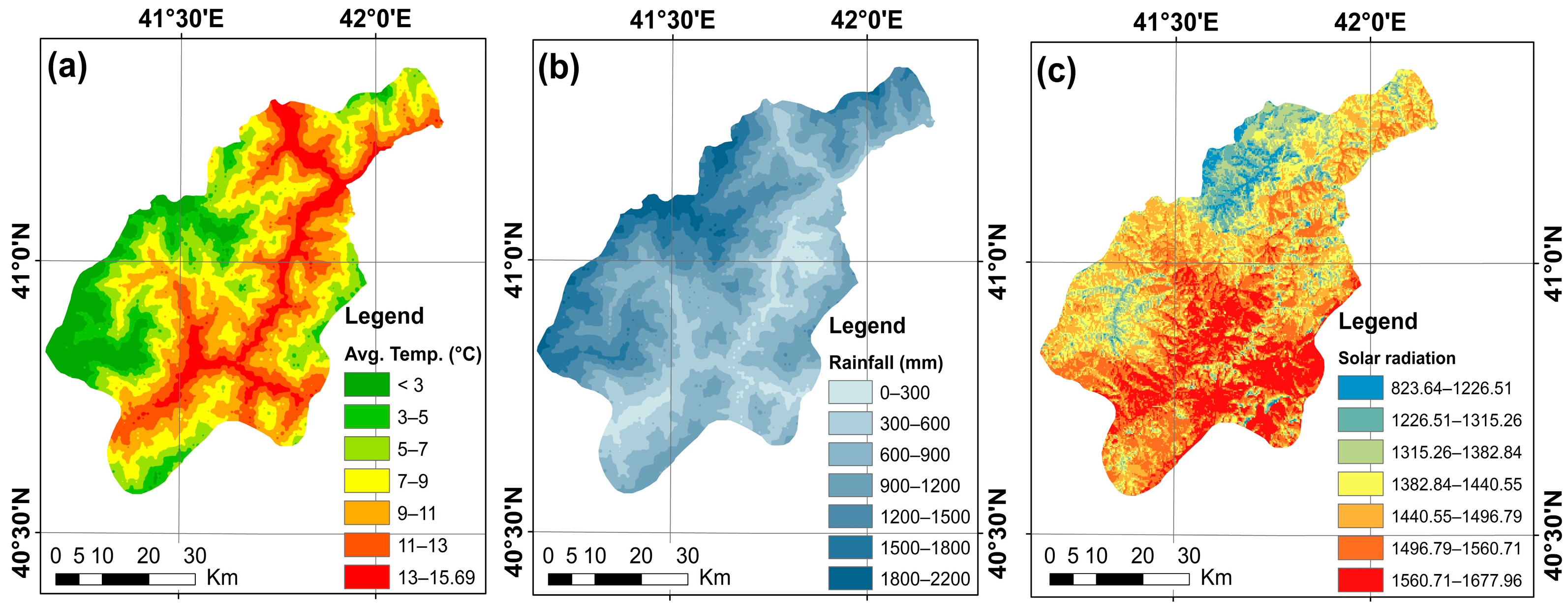
The climate characteristics of the current olive fields in the study area are presented in Table 4. Accordingly, it was observed that 62.27% of the current olive fields are located in the 300–600 mm precipitation zone, and 30.55% receive precipitation below 300 mm. Koca [2] and Çelik and Cin [12] stated that the olive tree can be grown without irrigation in places where the annual precipitation is at least 600 mm; however, irrigation should be carried out especially in summer in order to increase yield and quality. Ozturk et al. [6], on the other hand, stated that 85% of the olives cultivated in the world are not irrigated and therefore olives can be considered as a drought-resistant species. In addition to this, Guo et al. [31] and Gucci and Fereres [74] stated that the annual precipitation should be over 600 mm, while Shadeed et al. [13] stated that olive cultivation can be carried out with precipitation between 200–300 mm. However, considering the fact that humidity and high precipitation reduce the oil rate in olives, while the inadequacy in humidity and precipitation reduces the yield [49], we can say that the precipitation values in the study area are at a good level for olive farming.
It is also stated in the literature that olive plants can be grown in regions with an average annual temperature of 15–20 °C and can tolerate temperatures up to 35–40 °C at the highest [49] and must be irrigated in order to withstand temperatures above 40 °C [2]. In addition, it is emphasized that the lowest temperature for olive cultivation should not fall below −7 °C [31,47,52,75], and these values define the geographical areas where olive cultivation can be carried out. In this context, when the study area is examined, it is seen that 94.01% of the current olive fields have average annual minimum temperatures between 6–10 °C, 78.76% have average annual temperatures between 11–15.69 °C, and 95.89% have average annual maximum temperatures between 17–21.86 °C. Furthermore, the lowest temperature in the study area was measured at −6 °C in December, while the highest temperatures were measured between 30.4–37.9 °C in August. There are very few days when the temperature drops below zero or rises above 30 °C in the study area [76]. These figures show that the climate characteristics of the study area are compatible with the climate demand of the olive tree.
Considering the current olive fields in terms of solar radiation, another climate factor, it was observed that 88.48% of the olive fields are located in regions with a solar radiation value of 1315.26–1560.71 kWh/m2 (Table 4). As Guo et al. [77] point out, substantial amounts of sunshine are favorable for the production of olive fruit.
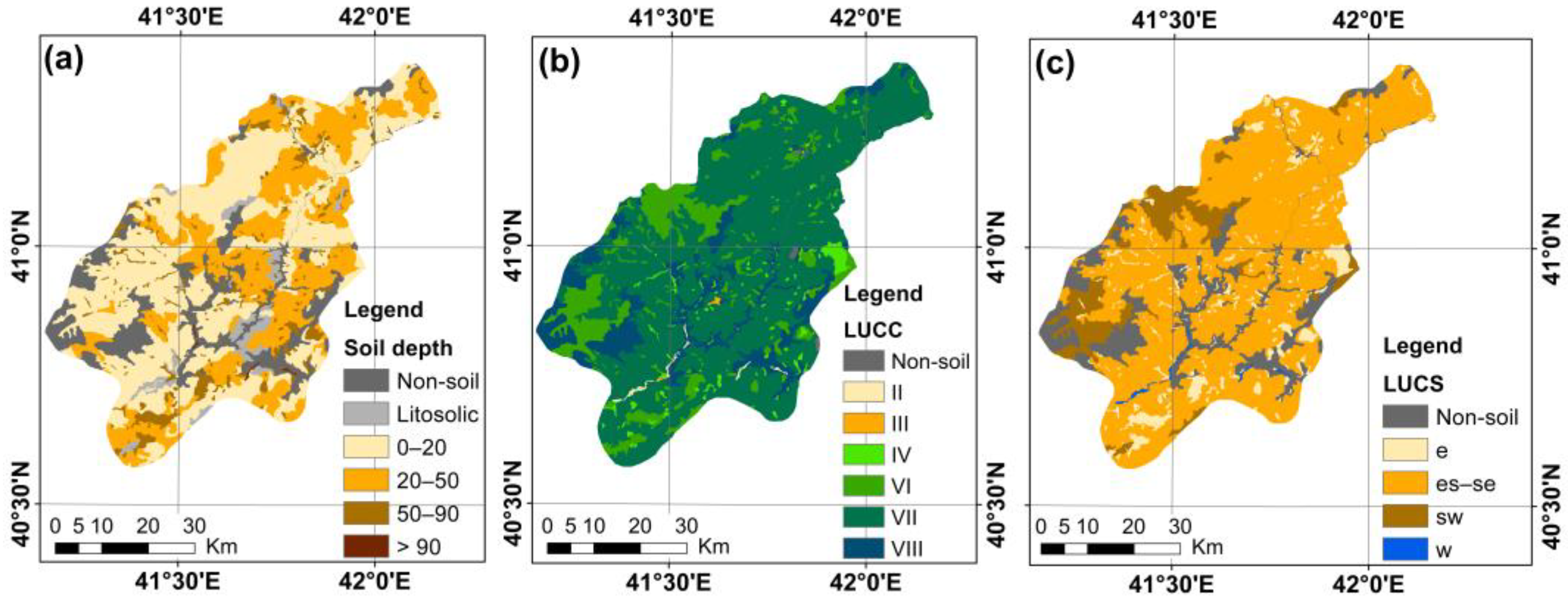
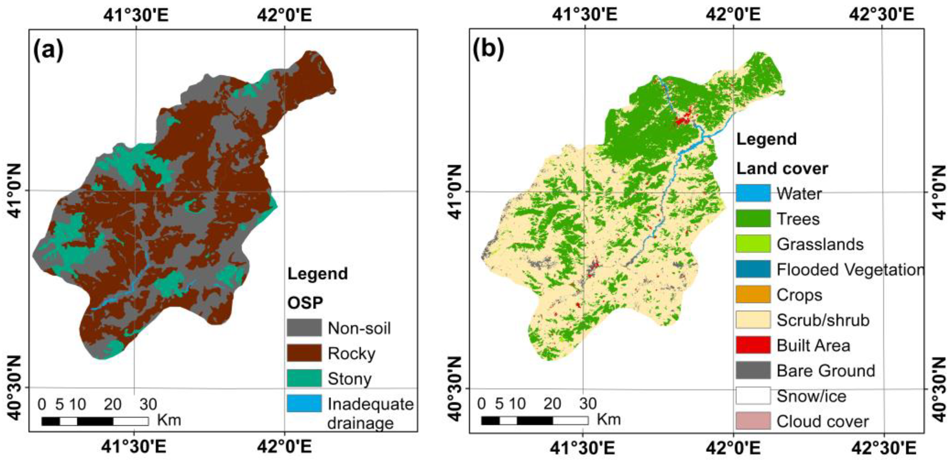
Although the olive plant does not show much selectivity in terms of soil requirements, Koca [2] stated that sandy loamy, loamy, loamy-sandy, clayey-loamy, and silty-loamy soils are suitable for olive trees with their permeable structures and sufficient water-holding capacities. In addition, Guo et al. [31] stated that while neutral and calcareous soils are suitable for olive cultivation, sticky yellow, ginger stone, and sand yellow soils are not. It can be seen that 91.86% of the olive fields taken into consideration in the study are in the M (brown forest soils) soil group and 2.69% are in the A (alluvial) soil group (Table 5). It was reported that brown forest soil (M) is used for perennial orchards such as olives, apples, pears, and vines, and has clayey-loamy and sandy-clayey-loamy textures [78]. At the same time, Hantekin [3], Varol [47], and Tuğaç and Sefer [4] stated that soils rich in nutrients, without salinity problems, and with good water holding capacity are suitable for olive cultivation. In this context, sub-capability classification (LUCS) is determined by the land capability classification’s limiting factors [18,79]. Approximately 53.63% of the current olive fields in the study area have slope and erosion damage, and soil inadequacy (es-se), and 38.23% have slope and erosion damage constraints. The city’s rough and highly sloping land structure has caused erosion sensitivity and insufficient soil depth problems and has caused agriculture to be carried out by forming terraces in practice. In fact, when the soil depths of the olive fields are examined, it can be seen that 38.23% of them are in the middle depth group, while 32.92% of them are in the shallow and very shallow groups. While the best depth for olive cultivation is considered to be between 1 m and 1.5 m, it is stated that the olive tree can provide a reasonable yield at half a meter depth under suitable conditions [1]. While generally less sloping and alluvial areas are used for field agriculture in Turkey [2], it has been seen that olive production can be carried out on barren, stony, rocky, pebbly, sandy, and calcareous soils where agriculture cannot be carried out efficiently [12]. A similar situation is encountered in Artvin Province as well. Soils are classified into eight classes in the creation of LUCCs [80] based on the limits they impose on the agricultural crops to be grown on them. While lands with class I land use capability are considered the best for cultivation, places with class VIII soil capability are considered inappropriate for cultivation [5]. Class VI lands are those used for forests or pastures and require a moderate level of measures, while class VII lands are those with steep slopes or high erosion risk, as well as those with stony, shallow, or dry soils, or other undesirable soil types [18]. Approximately 70.65% of the olive fields taken into consideration in this study are class VI and VII lands (Table 5). In the study conducted by Tuğaç and Sefer [4], it can be seen that class I-VII lands are considered suitable for olive cultivation.
Lastly, the land cover parameter is addressed in this title, where the characteristics of the current olive fields are examined. In this context, it can be seen that 29.16% of the olive fields are in the trees category, 56.13% are in the scrub/shrub category, and 12.22% are in the built area category (Table 6). The surface area of the olive plots used for the training of the RF algorithm varies between 6.36 m2 and 8708.17 m2. In particular, the fact that olive plots with an area of fewer than 200 m2 are located in the village settlements caused olive fields to be included in the built area category.
At this point, it can be said that the climate, soil, and topography characteristics of the olive fields in the selected study area of Artvin are compatible with the ecological demands of the olive tree.

3.3. Suitability Evaluation for Olive Cultivation with RF Algorithm

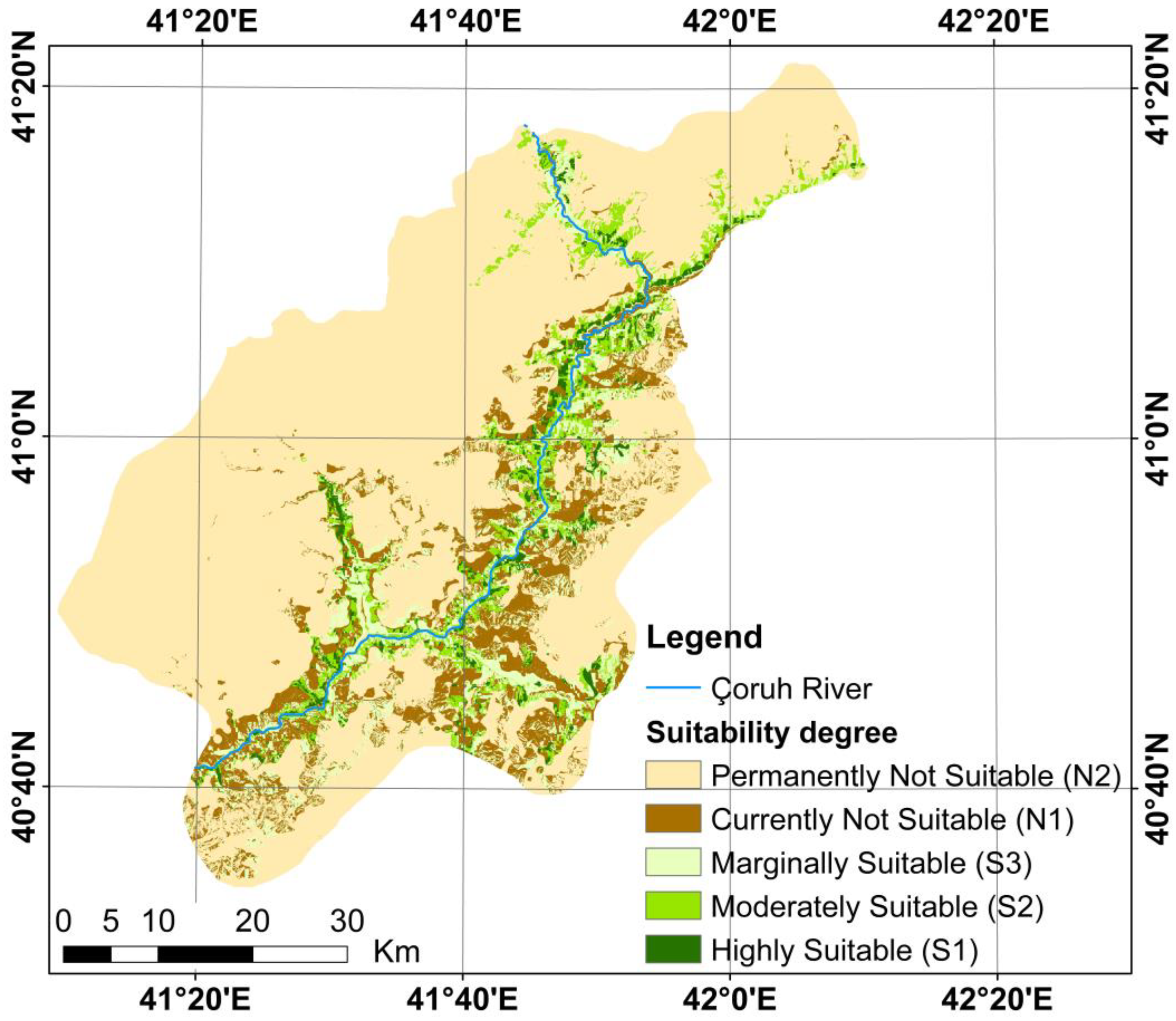
At this stage of the study, suitability analysis for olive farming was carried out using the RF algorithm with 10 parameters that were determined not to be multicollinear and to be effective in olive farming, and then a suitability map for olive farming was produced (Figure 8). The results of the suitability evaluation were classified into five classes of natural breaks (currently not suitable (N1), permanently not suitable (N2), highly suitable (S1), moderately suitable (S2), and marginally suitable (S3)) according to FAO guidelines [14,18].
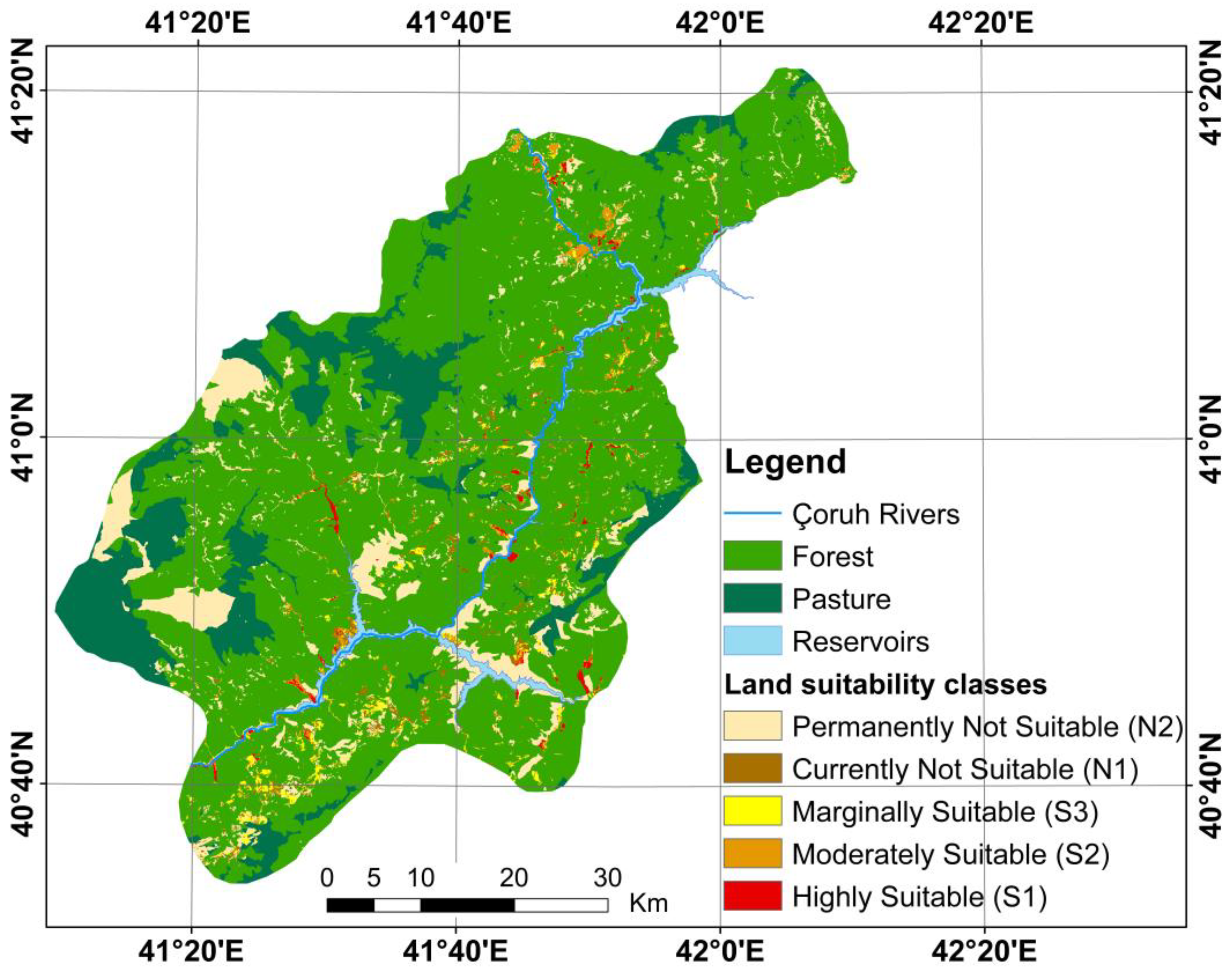
Because agricultural activities are not permitted in forest and pastureland under Turkish law, and water is being/will be held in the aforementioned dams, these regions were eliminated from the suitability map, and the final suitability map was created (Figure 9). Figure 10 shows the areal distribution graph of suitability evaluation groups.
According to the land suitability map, 17.59% (60,981.04 ha) of the study area is suitable for olive cultivation, but 12.40% (3153.86 ha) of this area cannot be used for olive farming since it has a forest and pasture nature, and 18.09% (3832.61 ha) of it is flooded/will be flooded due to dams. As a result, while 2.65% (53,994.57 ha) of the study area is suitable for olive cultivation, 97.35% (90,988.24 ha) is permanently and currently unsuitable (Figure 10). Thus, on the scale of the study area, a total area of 53,994.57 hectares, 7666.02 hectares of which is highly suitable, was found to be suitable for olive cultivation. In the study, it can be seen that the ecological demands of olive trees (especially climate and topography) are effective in the low ratio of suitable areas for olive cultivation. In addition, the rapid increase in elevation in the study area, and therefore the decrease in temperature, as well as flooding of the valley floor due to large dams, limited the areas where olive trees can grow. At the same time, the fact that the dominant land cover in the city is forest and pasture with 86.24% became effective in this result. Bilgilioğlu [5], in his study in Mersin, also found that 8% of the study area is suitable for olive cultivation and the remaining area is unsuitable.
It is also important to analyze the effects and relative importance levels of the parameters used in researching the suitability of the land for olive cultivation on a regional scale. In this context, the relative importance levels of the parameters used for olive cultivation with the RF algorithm are seen in Figure 11. This figure was produced using the built-in variable importance (or feature importance) function (varImp) of the RF algorithm. The variable importance function assigns a score that expresses how useful the input variables are in estimating a target variable, using techniques such as Gini importance and permutation variable importance [81]. Relative importance scores can be used in a predictive model to better understand the data and the model and reduce the number of input features. In the RF model produced in this study, average temperature and annual total precipitation were the two most important and effective parameters, while LUCS and slope were the least important and effective parameters. Again, solar radiation, aspect, land cover, OSP, soil depth, and LUCC parameters were also effective in order of importance (Figure 11).
Similarly, Ustaoğlu and Uzun [49] also determined temperature and precipitation as the most effective parameters for olive cultivation. However, Bilgilioğlu [5] found that land use capability, the average annual temperature, annual average precipitation, and elevation criteria are more effective than other criteria in determining the sites suitable for olive cultivation.

3.4. Validation of the Suitability Evaluation Model

One of the most important stages of a map generation process based on an ML-based regression model is the validation of the model outputs or predicted data. In this study, the area under the receiver characteristic curve (AUC-ROC) approach was used to validate the reliability of the olive farming suitability map produced using the RF algorithm. AUC-ROC is a widely used approach to evaluate the overall performance of prediction models in many different ML-based applications [82,83,84]. The axes of the ROC curve represent sensitivity (true positive rate) and 1-specificity (false positive rates). The predictive ability of the model increases as the AUC value of the ROC curve, which varies between zero and one, approaches one [85]. Many studies in the literature state that an AUC value between 0.5 and 0.6 performs poorly, an AUC value between 0.6 and 0.7 performs averagely, an AUC value between 0.7 and 0.8 performs well, an AUC value between 0.8 and 0.9 performs very well, and an AUC value between 0.9 and 1.0 performs excellently [86,87].
On the other hand, two different ROC curves are used to evaluate the performance of a model. These are the success rate curve and the prediction rate curve [88]. While the success rate curve is produced using the training data set, the prediction rate curve is produced using the validation data set [69]. The predictive ability of a model is evaluated using the prediction rate curve. In this study, the success rate curve was produced using the training data set and the prediction rate curve was produced using the validation data set (Figure 12). The AUC values of the curves were determined as 0.988 and 0.978, respectively. These AUC values show that the RF model has excellent performance.

3.5. Constraints and Prospects of This Study

Although an up-to-date, robust, and valid method or approach was employed in this study to identify possible locations for olive cultivation, a number of challenges or limits were also observed. One of the most significant constraints of the study is the scarcity of meteorological stations in the city. Climate data, as stated in this study and many other studies in the literature, are the most crucial and determining element in identifying olive areas [4,37,49]. Therefore, this constraint is critical. Extending the meteorological station network to precisely model the temperature and precipitation distribution in the study area will contribute significantly to such investigations. On the other hand, it can be said that the northern parts of Turkey will be more suitable for olive production, given the fact that the climate has a significant effect on olive cultivation and the prediction that the climate crisis will have significant effects, especially in the Mediterranean region in the future [89]. In a study conducted in Italy, it was determined that olive groves will expand in the country’s northern regions [90].
Another challenge encountered in the study was access to parcels where olive cultivation is already taking place. It was stated that the olive inventory data used in the study was produced from the parcels registered in the Farmer Registration System. However, it is known that there are olive groves throughout the province that are not registered in the Farmer Registration System. This affects the number of pixels in the ML algorithm’s training and validation datasets. As is well known, the more samples in the training and validation datasets, the better the model’s accuracy and prediction performance. In this context, as one of the future studies, it is intended for olive fields to be determined by classifying them from high-resolution current satellite images, as in similar studies in the literature. At the same time, additional work will be carried out to expand the number of ML algorithms employed in the study after the inventory data are developed. According to the literature [91,92], tree-based ensemble learning algorithms outperform standalone models in terms of prediction performance. Therefore, in future studies, it is planned for ML algorithms such as extreme gradient boosting (XGBoost), AdaBoost, CatBoost, and LightGBM as well as the RF algorithm to be used to determine potential olive areas in Artvin and to compare their performance.

4. Conclusions

In this work, a model was constructed using the RF algorithm to find suitable areas for olive cultivation on a regional scale in Artvin Province, employing 10 criteria that are largely linked to the topography, soil, and climate features of the area. The ecological conditions affecting the olive production in Artvin were found with the help of the RF model’s construction and validation process in which 575 plots currently used for olive cultivation were examined. Thus, suitable locations for olive farming were determined. The prediction performance of the RF model was determined as 0.978 using the AUC-ROC criterion, which is frequently utilized in the performance evaluation of ML-based prediction models. This finding demonstrates that the RF algorithm may be used successfully to determine suitable areas for olive production in particular and crop-based land suitability research in general.
Because the province of Artvin is compatible with the ecological demands of olive cultivation, it is possible to say that olive cultivation in the city can be improved. However, factors such as (i) the flooding of the valley due to the construction of three large dams, (ii) the widespread forest–pasture land cover of the city and the legal protection status of these areas, and (iii) the specific ecological requirements (e.g., elevation) of the olive plant have resulted in a low proportion of suitable areas for olive cultivation.
For this reason, it is critical that these limited and qualified areas, which have been judged to be acceptable for olive production, are exploited to meet the region’s olive demand while also providing an alternative to the olive fields that have been inundated because of the large dams. Finally, this study will contribute to the studies being conducted by the Artvin Provincial Directorate of Agriculture and Forestry to establish additional olive fields, particularly for cultivating Butko, a regional olive variety.
The Aegean, Mediterranean, and Marmara regions in Turkey are the locomotives of olive production, in that order. The Black Sea Region accounts for only 0.2% of our country’s olive production. The exports of both table olives and olive oil are quite important to the national economy. The expansion of olive cultivation in the Black Sea Region will make significant contributions to the region’s and country’s economy. Therefore, studies to discover suitable areas for olive cultivation, such as this one, are critical to increasing olive production in the Black Sea Region. Indeed, policies should be developed to ensure that the Ministry of Agriculture and Forestry supports studies aimed at determining suitable sites for olive cultivation.
Moreover, it is frequently emphasized in the literature that differences in opinion and practice on issues such as the distribution of Turkey’s lands based on their intended use, such as which lands should be allocated for agriculture and which lands should be allocated for pasture or settlement, have yet to be resolved. For this reason, it is clear that there is a need for a policy and planning approach that takes into account the characteristics (e.g., attributes and constraints) of the land. In this context, it will be very useful to consider crop-based suitability, such as olive, in the studies to be carried out for optimal land use.

Author Contributions

Conceptualization, A.Y.O. and H.A.; methodology, A.Y.O. and H.A.; software, H.A.; validation, H.A.; formal analysis, H.A. and A.Y.O.; investigation, A.Y.O.; resources, H.A.; data curation, H.A. and A.Y.O.; writing—original draft preparation, A.Y.O. and H.A.; writing—review and editing, A.Y.O. and H.A.; visualization, H.A. and A.Y.O. All authors have read and agreed to the published version of the manuscript.

Funding

This research received no external funding.

Institutional Review Board Statement

Not applicable.

Informed Consent Statement

Not applicable.

Data Availability Statement

All the data are reported in this study. Additional details are available from the corresponding author upon request.

Conflicts of Interest

The authors declare no conflict of interest.

References

  1. Alshammari, H.H.; Altaieb, M.O.; Boukrara, A.; Gasmi, K. Expansion of the olive crop based on modeling climatic variables using geographic information system (GIS) in Aljouf region KSA. Comput. Electron. Agric. 2022, 202, 107280. [Google Scholar] [CrossRef]
  2. Koca, N. The geographical principals of olive cultivation in Canakkale. Marmara Geogr. J. 2004, 9, 119–138. [Google Scholar]
  3. Hantekin, O. An Analysis of Physical Geography Conditions That Affect Olive Agriculture in Akhisar District of Manisa. Master’s Thesis, Sakarya University Institute of Social Sciences, Sakarya, Turkey, 2019. [Google Scholar]
  4. Tuğaç, M.G.; Sefer, F. GIS-based multi-criteria land suitability analysis for determining olive (Olea europaea L.) cultivation areas in Turkey. EU J. Agric. Fac. 2021, 58, 97–113. [Google Scholar] [CrossRef]
  5. Bilgilioğlu, S.S. Land suitability assessment for Olive cultivation using GIS and multi-criteria decision-making in Mersin City, Turkey. Arab. J. Geosci. 2021, 14, 2434. [Google Scholar] [CrossRef]
  6. Ozturk, M.; Altay, V.; Gönenç, T.M.; Unal, B.T.; Efe, R.; Akçiçek, E.; Bukhari, A. An overview of olive cultivation in Turkey: Botanical features, eco-physiology and phytochemical aspects. Agronomy 2021, 11, 295. [Google Scholar] [CrossRef]
  7. Alvarez, S.; Soriano, M.A.; Landa, B.B.; Gómez, J.A. Soil properties in organic olive groves compared with that in natural areas in a mountainous landscape in southern Spain. Soil Use Manag. 2007, 23, 404–416. [Google Scholar] [CrossRef]
  8. Doğan, B.; Gülser, C. Soil quality assessment for olive groves areas of Menderes District, Izmir-Turkey. Eurasian J. Soil Sci. 2020, 9, 298–305. [Google Scholar] [CrossRef]
  9. Tombesi, A.; Tombesi, S. Orchard planning and planting. In Production Techniques in Olive Growing; Sbitri, M.O., Serafini, F., Eds.; International Olive Council: Madrid, Spain, 2007. [Google Scholar]
  10. Turkish Statistical Institute (TSI). 2023. Available online: https://data.tuik.gov.tr/Bulten/Index?p=Bitkisel-Uretim-Istatistikleri-2022-45504 (accessed on 13 January 2023).
  11. Alevkayalı, Ç.; Tağıl, Ş. Assessment of agricultural land-use suitability levels in the Gulf of Edremit. J. Geogr. 2020, 40, 135–147. [Google Scholar] [CrossRef]
  12. Çelik, S.; Cin, P. Olive agriculture in Kilis. J. Int. Soc. Res. 2021, 14, 200–214. [Google Scholar] [CrossRef]
  13. Shadeed, S.; Alawna, S.; Riksen, M.; Fleskens, L. Land suitability mapping for rainfed olive tree plantation in the West Bank, Palestine. Desalin. Water Treat. 2022, 268, 194–204. [Google Scholar] [CrossRef]
  14. FAO. A framework for land evaluation. In Soils Bulletin 32; Food and Agriculture Organization of the United Nations: Rome, Italy, 1976. [Google Scholar]
  15. Senagi, K.M.; Jouandeau, N.; Kamoni, P. Machine learning algorithms for predicting land suitability in crop production: A review. In Proceedings of the Advances in Mass Data Analysis of Images and Signals in Medicine, Biotechnology, Chemistry and Food Industry 12th International Conference, MDA 2017, New York, NY, USA, 8–11 July 2017; p. 124. [Google Scholar]
  16. Akbulak, C. Land use suitability analysis of the upper basin of the Kara Menderes River using analytical hierarchy process and geographical information systems. J. Hum. Sci. 2010, 7, 557–576. [Google Scholar]
  17. Mokarram, M.; Aminzadeh, F. GIS-based multicriteria land suitability evaluation using ordered weight averaging with fuzzy quantifier: A case study in Shavur Plain, Iran. Int. Arch. Photogramm. Remote Sens. Spat. Inf. Sci. 2010, 38, 508–512. [Google Scholar]
  18. Akıncı, H.; Yavuz Özalp, A.; Turgut, B. Agricultural land use suitability analysis using GIS and AHP technique. Comput. Electron. Agric. 2013, 97, 71–82. [Google Scholar] [CrossRef]
  19. Dengiz, O.; Ormancı, İ.F.; Özkan, B. Determination of agricultural suitability classes using multi-criteria decision analysis and linear combination technique. A case study; Ankara-Gölbaşi special environmental protection area and its near vicinity. J. Soil Sci. Plant Nutr. 2022, 10, 44–57. [Google Scholar] [CrossRef]
  20. Dengiz, O. Land suitability assessment for rice cultivation based on GIS modeling. Turk. J. Agric. For. 2013, 37, 326–334. [Google Scholar] [CrossRef]
  21. Delibaş, L.; Bağdatlı, M.C.; Danışman, A. Determined appropriate area of walnut analyzing properties of some soils using Geographic Information Systems (GIS): The case of central village Tekirdag province. GU J. Sci. Technol. 2015, 5, 50–59. [Google Scholar] [CrossRef] [Green Version]
  22. Zhang, J.; Su, Y.; Wu, J.; Liang, H. GIS based land suitability assessment for tobacco production using AHP and fuzzy set in Shandong province of China. Comput. Electron. Agric. 2015, 114, 202–211. [Google Scholar] [CrossRef]
  23. Tercan, E.; Dereli, M.A. Development of a land suitability model for citrus cultivation using GIS and multi-criteria assessment techniques in Antalya province of Turkey. Ecol. Indic. 2020, 117, 106549. [Google Scholar] [CrossRef]
  24. Tercan, E.; Dengiz, O.; Özkan, B.; Dereli, M.A.; Öztekin, Y.B. Geographic information system–assisted site quality assessment for hazelnut cultivation using multi-criteria decision analysis in the Black Sea region, Turkey. Environ. Sci. Pollut. Res. 2022, 29, 35908–35933. [Google Scholar] [CrossRef] [PubMed]
  25. Xing, W.; Zhou, C.; Li, J.; Wang, W.; He, J.; Tu, Y.; Cao, X.; Zhang, Y. Suitability Evaluation of Tea Cultivation Using Machine Learning Technique at Town and Village Scales. Agronomy 2022, 12, 2010. [Google Scholar] [CrossRef]
  26. Salata, S.; Ozkavaf-Senalp, S.; Velibeyoğlu, K.; Elburz, Z. Land suitability analysis for vineyard cultivation in the Izmir metropolitan area. Land 2022, 11, 416. [Google Scholar] [CrossRef]
  27. Stanchi, S.; Godone, D.; Belmonte, S.; Freppaz, M.; Galliani, C.; Zanini, E. Land suitability map for mountain viticulture: A case study in Aosta Valley (NW Italy). J. Maps 2013, 9, 367–372. [Google Scholar] [CrossRef] [Green Version]
  28. Elaalem, M. A comparison of parametric and fuzzy multi-criteria methods for evaluating land suitability for olive in Jeffara plain of Libya. APCBEE Procedia 2013, 5, 405–409. [Google Scholar] [CrossRef] [Green Version]
  29. Shiri, Z.M.; Farbodi, M. Qualitative evaluation of land suitability for olive, potato and cotton cultivation in Tarom in Zanjan. agriTECH 2022, 42, 102–112. [Google Scholar] [CrossRef]
  30. Bienes, R.; Rastrero, M.R.; Fernandez, J.G.; Garcia-Diaz, A.; Sastre, B.; Gumuzzio, A. Methodology for edaphoclimatic assessment of olive cultivation: Application to the area of the quality mark “Olive Oil Madrid” (Spain). Span. J. Soil Sci. 2018, 8, 74–101. [Google Scholar] [CrossRef]
  31. Guo, X.; Yan, D.; Fan, J.; Zhu, W.; Li, M.H. Using GIS and fuzzy sets to evaluate the olive tree’s ecological suitability in Sichuan Province. Comput. Sci. Eng. 2010, 12, 20–27. [Google Scholar] [CrossRef]
  32. Apaydin, C.; Abdikan, S. Determination of hazelnut gardens by pixel-based classification methods using Sentinel-2 data. Geomatik 2021, 6, 107–114. [Google Scholar] [CrossRef]
  33. Ahmed, M.U.; Hussain, I. Prediction of wheat production using machine learning algorithms in northern areas of Pakistan. Telecomm. Policy 2022, 46, 102370. [Google Scholar] [CrossRef]
  34. Mota-Delfin, C.; López-Canteñs, G.d.J.; López-Cruz, I.L.; Romantchik-Kriuchkova, E.; Olguín-Rojas, J.C. Detection and counting of corn plants in the presence of weeds with convolutional neural networks. Remote Sens. 2022, 14, 4892. [Google Scholar] [CrossRef]
  35. Türk, S.T.; Balçık, F. Determination of hazelnut cropped areas by random forest algorithm and Sentinel-2 MSI: A case study of Piraziz. Geomatik 2023, 8, 91–98. [Google Scholar] [CrossRef]
  36. Taghizadeh-Mehrjardi, R.; Nabiollahi, K.; Rasoli, L.; Kerry, R.; Scholten, T. Land suitability assessment and agricultural production sustainability using machine learning models. Agronomy 2020, 10, 573. [Google Scholar] [CrossRef]
  37. Moriondo, M.; Stefanini, F.M.; Bindi, M. Reproduction of olive tree habitat suitability for global change impact assessment. Ecol. Modell. 2008, 218, 95–109. [Google Scholar] [CrossRef]
  38. Sesli, M.; Yegenoğlu, E.D.; Altıntas, V. Determination of olive cultivars by deep learning and ISSR markers. J. Environ. Biol. 2020, 41, 426–431. [Google Scholar] [CrossRef]
  39. Alshammari, H.H.; Shahin, O.R. An efficient deep learning mechanism for the recognition of olive trees in Jouf Region. Comput. Intell. Neurosci. 2022, 2022, 9249530. [Google Scholar] [CrossRef]
  40. Mendes, J.; Lima, J.; Costa, L.; Rodrigues, N.; Brandão, D.; Leitão, P.; Pereira, A.I. Machine Learning to Identify Olive-Tree Cultivars. In Proceedings of the Optimization, Learning Algorithms and Applications. OL2A 2022, Póvoa de Varzim, Portugal, 24–25 October 2022; Communications in Computer and Information Science; Pereira, A.I., Košir, A., Fernandes, F.P., Pacheco, M.F., Teixeira, J.P., Lopes, R.P., Eds.; Springer: Berlin/Heidelberg, Germany, 2022; Volume 1754, pp. 820–835. [Google Scholar] [CrossRef]
  41. Akinci, H.; Kilicoglu, C.; Dogan, S. Random forest-based landslide susceptibility mapping in coastal regions of Artvin, Turkey. ISPRS Int. J. Geo-Inf. 2020, 9, 553. [Google Scholar] [CrossRef]
  42. Mete, M.O.; Yomralıoğlu, T. GIS and machine learning based mass valuation of residential properties. In Proceedings of the 11th Turkish National Photogrammetry and Remote Sensing Union (TUFUAB) Technical Symposium, Mersin, Turkey, 19 May 2022. [Google Scholar]
  43. Yıldırımer, S.; Özalp, M.; Erdoğan Yüksel, E. Determining loss and degradation of lands as a result of large dam projects and associated road constructions within the Coruh River Watershed. ACU J. For. Fac. 2015, 6, 1–17. [Google Scholar] [CrossRef] [Green Version]
  44. Yıldız, S.M.; Şengün, H. An evaluation on relocation and expropriation problem caused by dam project in Çoruh valley. Acad. Rev. Econ. Adm. Sci. 2019, 12, 48–60. [Google Scholar]
  45. Artvin Directorate of Provincial Agriculture and Forestry. Activity Reports. Available online: https://artvin.tarimorman.gov.tr/FotografGalerisi/Galeri001/faaliyet%20raporlar%C4%B1/2020%20Faaliyet%20Raporu.pdf (accessed on 14 December 2022).
  46. Aytekin, O.; Aktaş, A. Yusufeli’de yapılmaları planlanan hidro-elektrik barajların kültür varlıklarına olan etkileri üzerine ön değerlendirme. In Proceedings of the Geçmişten Geleceğe Yusufeli Sempozyumu, Yusufeli, Artvin, Türkiye, 10–12 June 2010; p. 541. [Google Scholar]
  47. Varol, N. Organic Olives and Olive Seeds Breeding; Publication No: 101; Atatürk Horticultural Central Research Institute: Yalova, Turkey, 2021; p. 44. [Google Scholar]
  48. Arenas-Castro, S.; Gonçalves, J.F.; Moreno, M.; Villar, R. Projected climate changes are expected to decrease the suitability and production of olive varieties in southern Spain. Sci. Total Environ. 2020, 709, 136161. [Google Scholar] [CrossRef]
  49. Ustaoğlu, B.; Uzun, A. Determination of suitable land for special climate requirements of agricultural products in Mediterranean Region (Turkey) by weighted overlay analysis. J. Hum. Sci. 2018, 15, 2433–2453. [Google Scholar] [CrossRef] [Green Version]
  50. Yıldırım, M.U.; Demircan, M.; Özdemir, F.A.; Sarıhan, E.O. Effect of climate change on poppy (Papaver somniferum L.) production area. J. Field Crops Central Res. Ins. 2016, 25, 289–295. [Google Scholar] [CrossRef]
  51. Efe, R.; Soykan, A.; Sönmez, S.; Cürebal, İ. The effect of temperature conditions on olive (Olea europaea L. subsp. europaea) growing and phenological, pomological characteristics in Turkey. Ekoloji 2009, 18, 17–26. [Google Scholar] [CrossRef]
  52. Temuçin, E. An analysis of olive-producing regions in Türkiye according to temperature variable. Aegean Geogr. J. 1993, 7, 117–131. [Google Scholar]
  53. Alkan Akıncı, H.; Akıncı, H. Machine learning based forest fire susceptibility assessment of Manavgat district (Antalya), Turkey. Earth Sci. Inform. 2023, 16, 397–414. [Google Scholar] [CrossRef]
  54. Global Solar Atlas. Available online: https://globalsolaratlas.info/download/turkey (accessed on 6 July 2022).
  55. Tunalıoğlu, R.; Gökçe, O. Ege Bölgesi’nde Optimal Zeytin Yayılış Alanlarının Tespitine Yönelik Bir Araştırma; Tarım ve Köyİşleri Bakanlığı, Tarımsal Ekonomi Araştırma Enstitüsü Yayınları: Ankara, Türkiye, 2002; p. 76. [Google Scholar]
  56. Karabacak, K. Agricultural land use suitability analysis: The case of Nicosia District (TRNC). SDU Fac. Arts Sci. J. Soc. Sci. 2021, 52, 312–331. [Google Scholar]
  57. Lake, H.R.; Mehrjardi, R.T.; Akbarzadeh, A.; Ramezanpour, H. Qualitative and quantitative land suitability evaluation for olive (Olea europaea L.) production in Roodbar region, Iran. J. Agric. 2009, 4, 52–62. [Google Scholar]
  58. Sentinel-2 10-Meter Land Use/Land Cover. Available online: https://livingatlas.arcgis.com/landcover/ (accessed on 5 February 2023).
  59. Aslam, B.; Zafar, A.; Khalil, U. Comparative analysis of multiple conventional neural networks for landslide susceptibility mapping. Nat. Hazards 2023, 115, 673–707. [Google Scholar] [CrossRef]
  60. Kavzoglu, T.; Teke, A. Predictive performances of ensemble machine learning algorithms in landslide susceptibility mapping using random forest, Extreme Gradient Boosting (XGBoost) and Natural Gradient Boosting (NGBoost). Arab. J. Sci. Eng. 2022, 47, 7367–7385. [Google Scholar] [CrossRef]
  61. Wang, Y.; Fang, Z.; Wang, M.; Peng, L.; Hong, H. Comparative study of landslide susceptibility mapping with different recurrent neural networks. Comput. Geosci. 2020, 138, 104445. [Google Scholar] [CrossRef]
  62. Iban, M.C.; Sekertekin, A. Machine learning based wildfire susceptibility mapping using remotely sensed fire data and GIS: A case study of Adana and Mersin provinces, Turkey. Ecol. Inform. 2022, 69, 101647. [Google Scholar] [CrossRef]
  63. Rana, M.S.; Mahanta, C. Spatial prediction of flash flood susceptible areas using novel ensemble of bivariate statistics and machine learning techniques for ungauged region. Nat. Hazards 2023, 115, 947–969. [Google Scholar] [CrossRef]
  64. Wei, A.; Yu, K.; Dai, F.; Gu, F.; Zhang, W.; Liu, Y. Application of tree-based ensemble models to landslide susceptibility mapping: A comparative study. Sustainability 2022, 14, 6330. [Google Scholar] [CrossRef]
  65. Yi, Y.; Zhang, Z.; Zhang, W.; Jia, H.; Zhang, J. Landslide susceptibility mapping using multiscale sampling strategy and convolutional neural network: A case study in Jiuzhaigou region. Catena 2020, 195, 104851. [Google Scholar] [CrossRef]
  66. Lantz, B. Machine Learning with R; Packt Publishing Ltd.: Birmingham, UK, 2013; p. 396. [Google Scholar]
  67. Bhatia, A.S.; Chiu, Y.-W. Machine Learning with R Cookbook—Second Edition: Analyze Data and Build Predictive Models; Packt Publishing Ltd.: Birmingham, UK, 2017; p. 572. [Google Scholar]
  68. Lewis, N.D. Machine Learning Made Easy with R: Intuitive Step by Step Blueprint for Beginners; CreateSpace Independent Publishing Platform: Scotts Valley, CA, USA, 2017; p. 356. [Google Scholar]
  69. Akinci, H. Assessment of rainfall-induced landslide susceptibility in Artvin, Turkey using machine learning techniques. J. Afr. Earth Sci. 2022, 191, 104535. [Google Scholar] [CrossRef]
  70. Breiman, L. Random forests. Mach. Learn. 2001, 45, 5–32. [Google Scholar] [CrossRef] [Green Version]
  71. Kuhn, M. Building predictive models in R using the caret package. J. Stat. Softw. 2008, 28, 1–26. [Google Scholar] [CrossRef] [Green Version]
  72. Kesici, Ö. Kilis Yöresinin Coğrafyası; Araştırma Dizisi-1; Kilis Kültür Derneği Genel Yayını: Ankara, Türkiye, 1994. [Google Scholar]
  73. Tombesi, A.; Tombesi, S.; d’Andria, R.; Lavini, A.; Saavedra, M.; Jardak, T.; Fernández-Escobar, R. Production Techniques in Olive Growing. In Production Techniques in Olive Growing; Sbitri, M.O., Serafini, F., Eds.; International Olive Council: Madrid, Spain, 2007. [Google Scholar]
  74. Gucci, R.; Fereres, E. Fruit Trees, and Vines. Olive, in Crop Yield Response to Water; FAO Irrigation and Drainage Paper 66; Food and Agriculture Organization of the United Nations: Rome, Italy, 2012; pp. 300–313. [Google Scholar]
  75. Delgado, G.; Aranda, V.; Calero, J.; Sánchez-Marañón, M.; Serrano, J.M.; Sánchez, D.; Vila, M.A. Using fuzzy data mining to evaluate survey data from olive grove cultivation. Comput. Electron. Agric. 2009, 65, 99–113. [Google Scholar] [CrossRef]
  76. Turkish State Meteorological Service (TSMS). Climate Data for the Years 2010–2022; TSMS: Ankara, Turkey, 2022. [Google Scholar]
  77. Guo, X.; Yang, Y.; Liu, H.; Liu, G.; Liu, W.; Wang, Y.; Zhao, R.; Ming, B.; Xie, R.; Wang, K.; et al. Effects of solar radiation on dry matter distribution and root morphology of high yielding maize cultivars. Agriculture 2022, 12, 299. [Google Scholar] [CrossRef]
  78. Tümsavaş, Z.; Aksoy, E. Determination of soil fertility conditions of the brown forest great group soils. J. Agric. Fac. Uludag Univ. 2008, 22, 43–54. [Google Scholar]
  79. General Directorate of Agricultural Reform (TRGM), Toprak ve Arazi Sınıflaması Standartları Teknik Talimatı ve Ilgili Mevzuat. Available online: https://www.tarim.gov.tr/Documents/Mevzuat/Talimatlar/ToprakAraziSiniflamasiStandartlariTeknikTalimativeIlgiliMevzuat_yeni.pdf (accessed on 3 June 2013).
  80. The United States Department of Agriculture (USDA) National Soil Survey Handbook, Part 622. Available online: http://soils.usda.gov/technical/handbook/contents/part622.html (accessed on 3 June 2013).
  81. Probst, P.; Wright, M.; Boulesteix, A.-L. Hyperparameters and tuning strategies for random forest. WIREs Data Min. Knowl. Discov. 2019, 9, e1301. [Google Scholar] [CrossRef] [Green Version]
  82. Akinci, H.; Zeybek, M. Comparing classical statistic and machine learning models in landslide susceptibility mapping in Ardanuc (Artvin), Turkey. Nat. Hazards 2021, 108, 1515–1543. [Google Scholar] [CrossRef]
  83. El-Haddad, B.A.; Youssef, A.M.; Pourghasemi, H.R.; Pradhan, B.; El-Shater, A.-H.; El-Khashab, M.H. Flood susceptibility prediction using four machine learning techniques and comparison of their performance at Wadi Qena Basin, Egypt. Nat. Hazards 2021, 105, 83–114. [Google Scholar] [CrossRef]
  84. Piao, Y.; Lee, D.; Park, S.; Kim, H.G.; Jin, Y. Forest fire susceptibility assessment using google earth engine in Gangwondo, Republic of Korea. Geomat. Natl. Hazards Risk 2022, 13, 432–450. [Google Scholar] [CrossRef]
  85. Nhu, V.H.; Zandi, D.; Shahabi, H.; Chapi, K.; Shirzadi, A.; Al-Ansari, N.; Singh, S.K.; Dou, J.; Nguyen, H. Comparison of support vector machine, bayesian logistic regression, and alternating decision tree algorithms for shallow landslide susceptibility mapping along a mountainous road in the west of Iran. Appl. Sci. 2020, 10, 5047. [Google Scholar] [CrossRef]
  86. Chen, W.; Zhang, S.; Li, R.; Shahabi, H. Performance evaluation of the GIS-based data mining techniques of best-first decision tree, random forest, and naive Bayes tree for landslide susceptibility modeling. Sci. Total. Environ. 2018, 644, 1006–1018. [Google Scholar] [CrossRef] [PubMed]
  87. Akinci, H.; Yavuz Ozalp, A. Landslide susceptibility mapping and hazard assessment in Artvin (Turkey) using frequency ratio and modified information value model. Acta Geophys. 2021, 69, 725–745. [Google Scholar] [CrossRef]
  88. Althuwaynee, O.F.; Pradhan, B.; Lee, S. Application of an evidential belief function model in landslide susceptibility mapping. Comput. Geosci. 2012, 44, 120–135. [Google Scholar] [CrossRef]
  89. Todaro, V.; D’Oria, M.; Secci, D.; Zanini, A.; Tanda, M.G. Climate change over the Mediterranean Region: Local temperature and precipitation variations at five pilot sites. Water 2022, 14, 2499. [Google Scholar] [CrossRef]
  90. Mereu, V.; Iocola, I.; Spano, D.; Murgia, V.; Duce, P.; Cesaraccio, C.; Tubiello, F.N.; Fischer, G. Land suitability and potential yield variations of wheat and olive crops determined by climate change in Italy. Ital. J. Agron. 2008, 3, 797–798. [Google Scholar]
  91. Sahin, E.K. Assessing the predictive capability of ensemble tree methods for landslide susceptibility mapping using XGBoost, gradient boosting machine, and random forest. SN Appl. Sci. 2020, 2, 1308. [Google Scholar] [CrossRef]
  92. Merghadi, A.; Yunus, A.P.; Dou, J.; Whiteley, J.; ThaiPham, B.; Bui, D.T.; Avtar, R.; Abderrahmane, B. Machine learning methods for landslide susceptibility studies: A comparative overview of algorithm performance. Earth Sci. Rev. 2020, 207, 103225. [Google Scholar] [CrossRef]
Figure 1. Location map of the study area.
Agriculture 13 01208 g001
Figure 2. Areal change of olive groves in Artvin Province [45].
Agriculture 13 01208 g002
Figure 3. Meteorological maps of the study area: (a) average temperature, (b) average total precipitation, and (c) solar radiation.
Agriculture 13 01208 g003
Figure 4. Topographic maps of the study area: (a) elevation, (b) slope, and (c) aspect.
Agriculture 13 01208 g004
Figure 5. Soil properties maps of the study area: (a) soil depth, (b) LUCC, (c) LUCS.
Agriculture 13 01208 g005
Figure 6. (a) OSP map of the study area and (b) land cover map of the study area.
Agriculture 13 01208 g006
Figure 7. A general framework of land suitability for olive cultivation.
Agriculture 13 01208 g007
Figure 8. Land suitability map for olive cultivation.
Agriculture 13 01208 g008
Figure 9. The final land suitability map for olive cultivation.
Agriculture 13 01208 g009
Figure 10. The distribution of the suitability evaluation results based on the area and suitability degree.
Agriculture 13 01208 g010
Figure 11. Importance levels of parameters for olive cultivation using the RF algorithm.
Agriculture 13 01208 g011
Figure 12. Performance of the RF model in training and validation.
Agriculture 13 01208 g012
Table 1. Some characteristics of the evaluation parameters.
ParametersUnitData TypeScale/ResolutionData Source
Aver. annual precipitationMmPointMonthlyTSMS
Aver. annual temperature°CPointMonthlyTSMS
Annual max. temperature°CPointMonthlyTSMS
Annual min. temperature°CPointMonthlyTSMS
AspectCategoricalRaster10 mDEM
ElevationMVector1/25,000GDM
Erosion DegreeCategoricalVector1/25,000GDAR
Great soil groupCategoricalVector1/25,000GDAR
Land coverCategoricalRaster10 mESRI Land Cover
LUCCCategoricalVector1/25,000GDAR
LUCSCategoricalVector1/25,000GDAR
OSPCategoricalVector1/25,000GDAR
Slope%Raster10 mDEM
Soil depthMVector1/25,000GDAR
Solar RadiationkWh/m2Raster10 mGlobal Solar Atlas website
TSMS: Turkish State Meteorological Service; GDAR: General Directorate of Agricultural Reform; GDM: General Directorate of Mapping; DEM: digital elevation model.
Table 2. Multicollinearity analysis for suitability evaluation parameters.
ParametersVIFTOL
Aspect1.110690.90034
Average annual precipitation2.773180.36060
Average annual temperature3.398120.29428
Land cover1.137740.87894
LUCC1.281960.78006
LUCS1.625720.61511
OSP1.506710.66370
Slope1.256060.79614
Soil depth1.476700.67719
Solar Radiation1.380540.72435
Table 3. Topographic characteristics of the current olive cultivation areas.
ParameterAttributesValueNum. of PixelsRatio (%)
Elevation (m)130–51012529.68
510–8902214182.26
890–127031304.99
1270–16504572.19
1650–20305230.88
2030–2410600
2410–2790700
2790–3170800
3170–3550900
3550–39301000
Slope (%)0–21491.88
2–62130.51
6–1231304.99
12–2041626.22
20–3052158.26
30–45644317.02
>457159161.12
AspectFlat1401.53
N232812.59
NE31044.00
E42288.76
SE526710.26
S638114.64
SW729111.18
W827310.49
NW969126.55
Table 4. Climatologic characteristics of the current olive cultivation areas.
ParameterAttributesValueNum. of PixelsPixel (%)
Precipitation (mm)0–300179530.55
300–6002162162.27
600–90031877.18
900–1200400
1200–1500500
1500–1800600
1800–2200700
Tmin (°C)−7–2100
2–42190.73
4–63612.34
6–8434913.41
8–105209880.60
>106762.92
Tavg (°C)−2.81–3100
3–5200
5–731574.99
7–9439412.53
9–1151173.72
11–13684126.74
13–15.697163652.02
Tmax (°C)2–9100
9–11200
11–13300
13–154431.65
15–175642.46
17–19687233.50
19–21.867162462.39
Solar radiation (kWh/m2)823.64–1226.51100
1226.51–1315.2622268.68
1315.26–1382.84327210.45
1382.84–1440.55482331.62
1440.55–1496.79592935.69
1496.79–1560.71627910.72
1560.71–1677.967742.84
Table 5. Soil characteristics for current olive cultivation in Artvin.
ParameterAttributesValueNum. of PixelsPixel (%)
GSGY (high mountain meadow soil)700
X (basaltic soils)600
P (red–yellow podzolic soils)500
N (non-calcic brown forest soils)400
M (brown forest soils)3239191.86
CE (chestnut soils)200
A (alluvial)1702.69
Water bodies and urban fabric01425.45
Soil depth (cm)<90 (Deep)500
50–90 (Medium–deep)499538.23
20–50 (Shallow)31776.80
0–20 (Very Shallow)268026.12
Litosolic160923.40
Water bodies and urban fabric01425.45
OSPy (inadequate drainage)3702.69
t (stony)2160.61
r (rocky)172527.85
Water bodies and urban fabric0179268.84
LUCSw (wetness, inadequate drainage)4702.68
sw (soil inadequacy, wetness)300
es-se (slope, erosion, and soil inadequacy)2139653.63
e (slope and erosion damage)199538.23
Water bodies and urban fabric01425.46
LUCCI-II-III1–3702.69
IV455221.21
V500
VI644317.02
VII7139653.63
VIII81074.11
Water bodies and urban fabric0351.34
Erosion degreeVery weak1702.69
Moderate299538.23
Severe378730.23
Very severe460923.40
Null01425.45
Table 6. Land cover characteristics of current olive cultivation in Artvin.
ParameterAttributesValueNum. of PixelsPixel (%)
Land coverWater100
Trees275929.16
Grass (Rangeland)3140.54
Flooded Vegetation460.22
Crops500
Scrub/shrub6146156.13
Built Area731812.22
Bare Ground8451.73
Snow/ice/clouds9–1000
Disclaimer/Publisher’s Note: The statements, opinions and data contained in all publications are solely those of the individual author(s) and contributor(s) and not of MDPI and/or the editor(s). MDPI and/or the editor(s) disclaim responsibility for any injury to people or property resulting from any ideas, methods, instructions or products referred to in the content.

