Review

Agroforestry Extent in the United States: A Review of National Datasets and Inventory Efforts

1
USDA National Agroforestry Center, Lincoln, NE 68583, USA
2
USDA National Agroforestry Center, Burlington, VT 05405, USA
3
Nebraska Forest Service, University of Nebraska-Lincoln, Lincoln, NE 68503, USA
*
Author to whom correspondence should be addressed.
Agriculture 2022, 12(5), 726; https://doi.org/10.3390/agriculture12050726
Submission received: 19 April 2022 / Revised: 16 May 2022 / Accepted: 19 May 2022 / Published: 21 May 2022
(This article belongs to the Special Issue Agroforestry Planning)

Abstract

:
A comprehensive understanding of agroforestry adoption across a landscape is critical for effective agroforestry planning. The objectives of this study are to identify the sources of agroforestry data that can be used in the United States (U.S.) for national inventory purposes, discuss the possible uses and nuances of the datasets, synthesize the data to create regional maps, and provide recommendations for improving future agroforestry inventory efforts. To accomplish this, we queried multiple government databases containing agroforestry inventory data and spoke with agency representatives with in-depth knowledge of each dataset. Data from federal conservation programs were found to be useful for assessing practice-level adoption through a conservation program but not for general inventory use, since agroforestry systems can be established without federal assistance. For inventory purposes, the 2017 U.S. Census of Agriculture was found to be the most comprehensive dataset, with 30,853 farm operations reporting agroforestry use, representing 1.5% of all U.S. farms. However, this value is likely an underestimate, due to respondent unfamiliarity with agroforestry terminology. We propose several strategies to improve the accuracy of future agroforestry surveys, since a greater understanding of agroforestry adoption will influence decisions related to agricultural policies, technical assistance, and planning of these integrated systems.

1. Introduction

Agroforestry is the intentional integration of trees and shrubs into crop and animal farming systems. These systems encompass a suite of multifunctional land-use approaches that can enhance agricultural production, while delivering ecosystem services [1,2,3,4,5,6]. Although the benefits of agroforestry have a strong literature base from a biophysical perspective, advancement of agroforestry requires a comprehensive understanding of adoption by producers. Having a greater understanding of how many producers use agroforestry, along with associated demographic and biophysical variables is important for:
  • Helping producers make more informed decisions about their operations when designing and planning agroforestry systems.
  • Understanding how agroforestry implementation is changing over time.
  • Identifying trends and factors that may help increase successful adoption.
  • Identifying market opportunities for agroforestry-produced products and services.
  • Better matching of financial and technical support with producer demand.
  • Informing decision-making related to farm policies, funding, programs, research, and extension delivery.
  • Better estimating the ecosystem goods and services provided by agroforestry practices.
In the United States (U.S.), several recent reviews have been conducted on agroforestry adoption by aggregating data from regional producer surveys [7,8]. These reviews identified a need for a thorough analysis of agroforestry implementation on the national scale, since no such analysis has occurred in the U.S. Currently, the only national datasets on agroforestry implementation in the U.S. reside in United States Department of Agriculture (USDA) databases. One dataset comes from a single question in the 2017 Census of Agriculture (COA), which is administered by the USDA National Agricultural Statistics Service (NASS). The Yes/No question asked, “At any time in 2017, did this operation practice alley cropping, silvopasture, or forest farming, or have riparian forest buffers or windbreaks?” [9]. Because this question aggregated multiple agroforestry practices together, the data cannot be refined further by specific agroforestry practices. Additionally, these data cannot be compared with an earlier 2012 COA agroforestry question, which only asked about silvopasture and alley cropping. Unfortunately, these nuances sometimes result in data misinterpretation. For example, Bergmann et al. [10] described a SilvopastureRatio, which used the 2012 COA agroforestry question description for silvopasture and alley cropping and 2017 COA agroforestry data for all five practices to make inferences about silvopasture. Because of the aggregate nature of these data, such practice-level interpretations cannot be made.
National agroforestry data can also be found in other government databases focused on federal conservation programs, such as those from the USDA Natural Resources Conservation Service (NRCS) and the USDA Farm Service Agency (FSA). By design, these national datasets are specific to agroforestry systems established through federal conservation programs. However, there have been instances where conservation practice implementation data have been extrapolated to make inferences about the prevalence of specific agroforestry practices in the U.S. For instance, Davis and Rausser [11] used conservation program data to describe how silvopasture adoption is low in the U.S. because the number of acres established through USDA conservation programs was low. Unfortunately, interpretations like this cannot be made since agroforestry practices can be implemented without funding or technical assistance from federal conservation programs.
While national-level datasets exist for agroforestry implementation in the U.S., the data are in several different government databases and can be nuanced, especially when trying to assess trends over time. This leads to misrepresentation and incorrect use of data in both peer reviewed and popular literature. Additionally, while many of these data are publicly available, the agriculture, forestry, and conservation communities may be unaware of their existence or not know how to access the raw data. As such, the objectives of this review are to:
  • Identify federal sources of agroforestry data for inventorying purposes in the U.S.
  • Discuss the possible uses and nuances of the various datasets.
  • Synthesize the available agroforestry inventory data to create mapping products showcasing agroforestry adoption by state and county.
  • Provide strategies for improving future agroforestry survey and inventory efforts in the U.S. and abroad.
By providing insight into the various national agroforestry datasets available from the U.S. government, along with synthesizing information to create state-level maps, we hope to provide a greater understanding of how many producers use agroforestry, where systems exist across the country, and how these data can support a variety of policy, extension, research, and planning needs.

2. Materials and Methods

National datasets for agroforestry adoption in the U.S. were identified through recently published systematic reviews by the authors of this study [7,8]. These systematic reviews identified government databases as the only source for national-level datasets related to agroforestry adoption. As such, three reports describing agroforestry programs across the U.S. government were used as a starting point to identify potential data sources. The reports included:
  • Agroforestry Across USDA Agencies [12].
  • Guide to USDA Agroforestry Research Funding Opportunities [13].
  • USDA Agroforestry Strategic Framework: Fiscal Years 2019–2024 [14].
Additionally, representatives from the USDA Interagency Agroforestry Team (IAT) were contacted to inquire about additional data sources. The IAT is comprised of eight USDA agencies and is focused on identifying, assessing, and prioritizing agroforestry science and technology needs and outcomes across the U.S. [14]. Through this approach, data sources were identified for all eight IAT agencies.
Of the agroforestry datasets identified during the data collection phase, only the 2017 U.S. Census of Agriculture from NASS was utilized for creating regional maps, due to data availability for every state and county within the U.S. More specifically, NASS’s Quick Stats 2.0 was used to query the 2017 COA database to develop a customized table of agroforestry responses at the county level for all fifty states [15]. To determine the number of operations that answered “Yes” to using agroforestry, the query string was Census > Economics > Farm and Land and Assets > Practices > Area > Data Item > Practices, Alley Cropping and Silvopasture—Number of Operations > County > 2017. Although the Data Item menu just shows Alley Cropping and Silvopasture, this selection includes all five practices if the year 2017 is selected. For total number of farms per county, the query string was Census > Economics > Farm&Land&Assets > Farm Operations > Operations > Farm Operations—Number of Operations > Total > County > 2017. The agroforestry responses for individual states by county can also be found in Table 43 of Chapter 2—Selected Practices using the Census Data Query Tool. To map the data, the tables were copied into a Microsoft Excel spreadsheet and were merged with county spatial data using ArcGIS Pro. The U.S. County layer was downloaded as a shapefile from Esri [16]. Federal Information Processing System (FIPS) county codes were added to the NASS data in Excel. FIPS codes are a unique number identifier for each county. The Excel table and the spatial County layer were joined using the Join Field tool in ArcGIS Pro (version 2.73, Esri) using the FIPS codes. The resulting layer contained the NASS numbers according to county and were checked for accuracy before being mapped.
Agroforestry data from other government databases were reviewed but not included in mapping products due to the limited scope of the databases. However, these datasets are discussed in depth from a qualitative perspective in the following sections.

3. Results and Discussion

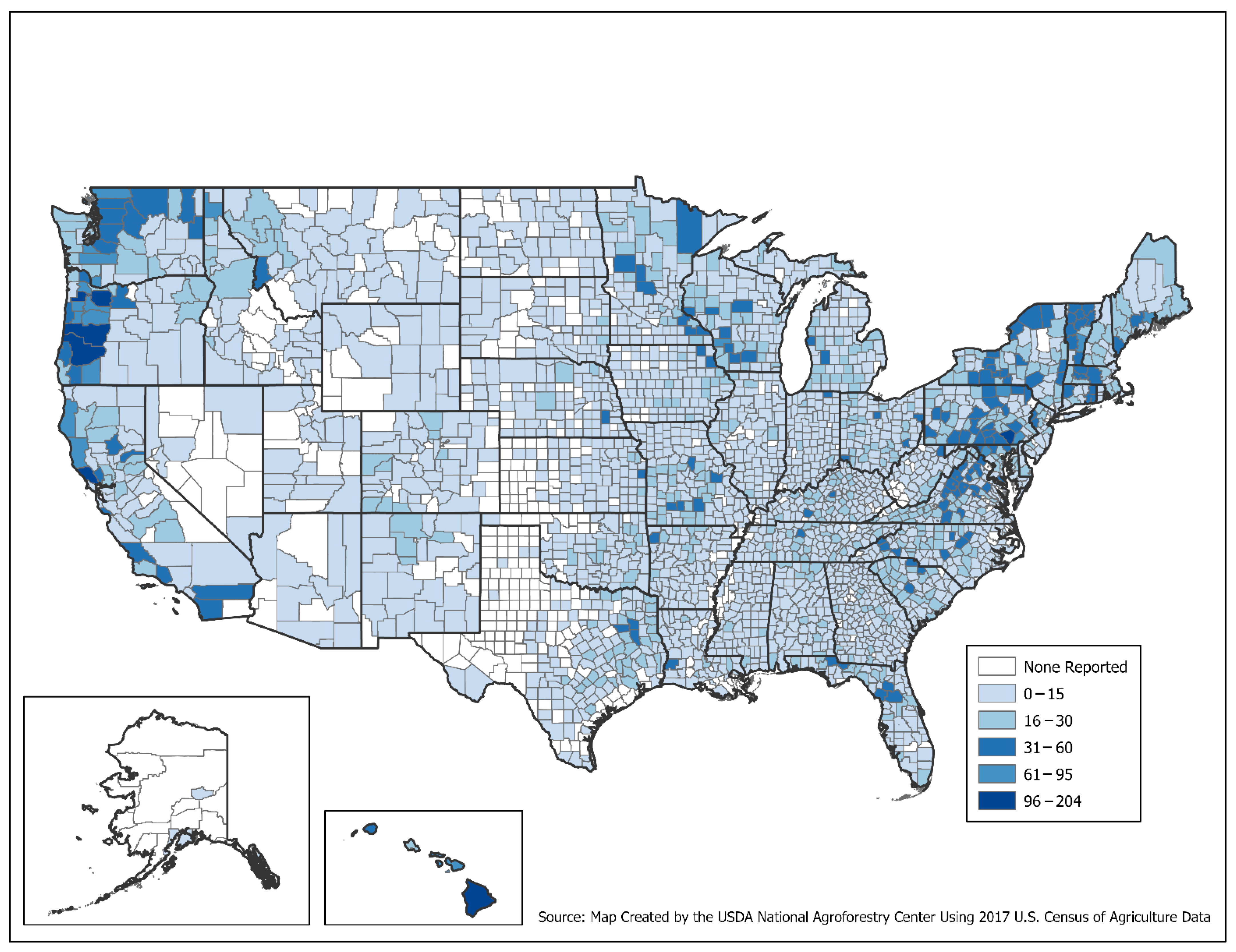
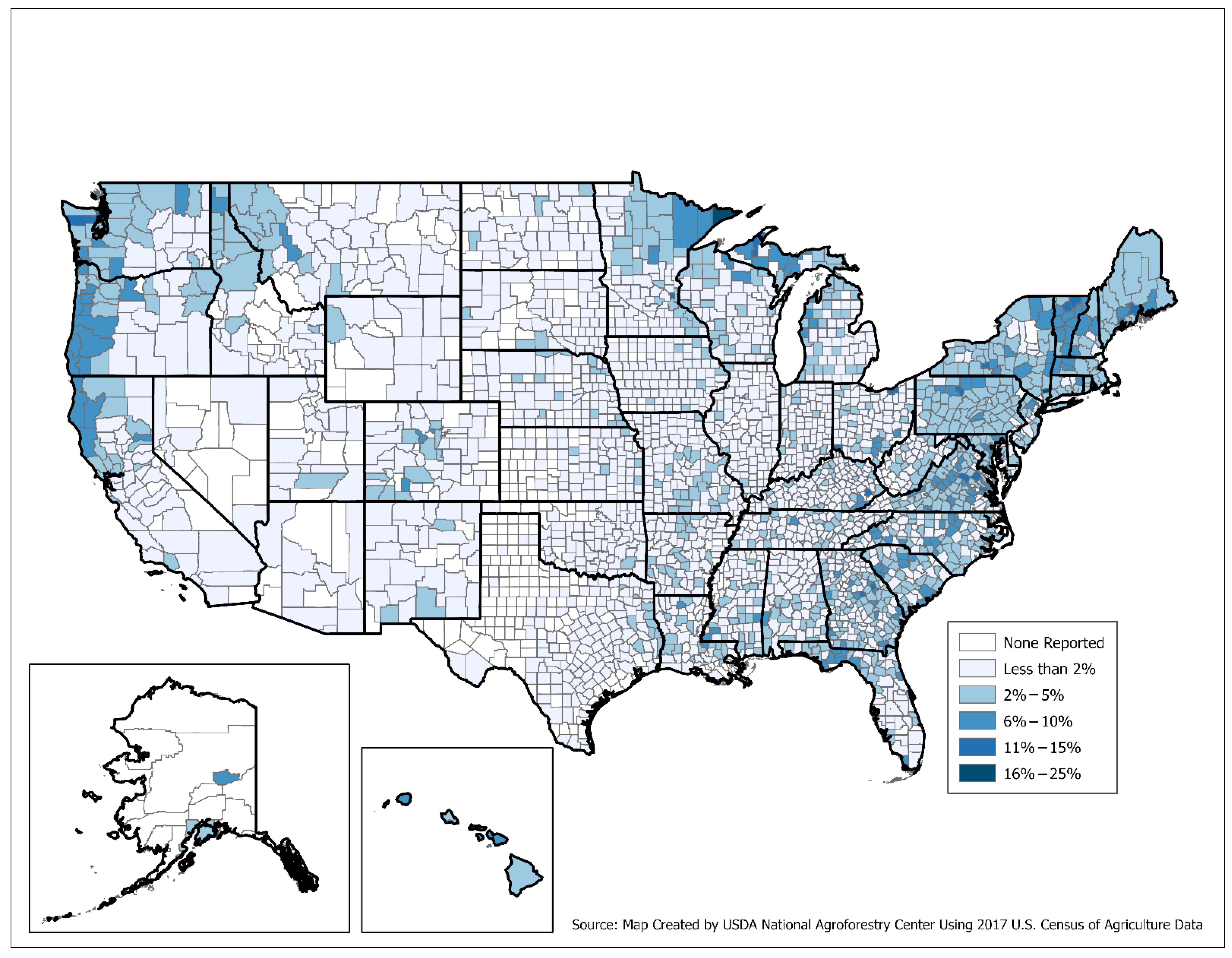
3.1. USDA NASS Census of Agriculture

Based on the 2017 COA, 30,853 farm operations responded that they had at least one agroforestry practice, representing 1.5% of all farm operations in the U.S. (Table 1 and Figure 1).
The states with the highest number of farms with an agroforestry practice include Texas, Pennsylvania, Missouri, Virginia, and Oregon. When viewed as a percentage of farms with an agroforestry practice at the state level, the top five states are Vermont (7.2%), Maine (4.8%), Hawaii (4.7%), Massachusetts (4.1%), and New Hampshire (4.1%), while the lowest state percentages were found in Arizona (0.2%), Nevada (0.3%), Utah (0.3%), Texas (0.5%), North Dakota (0.6%), and Wyoming (0.6%).
At the county level, the percentage of farms with agroforestry practices ranges from 0.0% to 25.0% (Figure 2). In general, counties with a higher percentage of farms with agroforestry were found in the Pacific Northwest, Mid-Atlantic, and Northeast regions.
Figure 3 offers an example of the county-level data at an individual state scale. Supplement File S1 provides individual county-level state maps and tables for all fifty states. Some counties can have particularly high percentages even when their state percentage is low. Factors that contribute to these differences may be due to local interest and expertise on implementing agroforestry practices, familiarity with practice names when responding to the COA question, or federal and state program availability. Future studies could expand upon this dataset to better understand some of these nuances and whether trends exist. These studies could also include detailed analysis of correlations between agroforestry adopters and other demographic or land-use decisions, such as conservation practices or organic management.

Comparison between the 2017 and 2012 Census of Agriculture

One of the benefits of the COA is the ability to assess agricultural trends over time since it occurs once every five years. In Table 43 of Chapter 2 from the 2017 COA, agroforestry data are presented for both the 2017 and 2012 COA years. However, the 2012 data have a footnote which says, “data for 2012 exclude operations that practiced forest farming or had riparian forest buffers or windbreaks” [17]. This footnote is included because the 2012 COA agroforestry question only asked if producers had practiced alley cropping and/or silvopasture. As such, the 2012 data cannot be compared with the 2017 agroforestry data. While the footnote details this important distinction, there have been media articles that have incorrectly suggested that the number of farm operations practicing agroforestry increased 10-fold from 2012 to 2017.

3.2. National Agroforestry Data from Other USDA Agencies

Few national data sources exist related to how many producers implement agroforestry on their operation other than the COA. Some researchers and practitioners have looked to data related to federal conservation program funding to understand implementation and retention of agroforestry and other conservation practices [18,19,20]. For example, Basche et al. [19] used data from EQIP to explore the potential to generate environmental health outcomes. This approach is effective at understanding conservation program adoption and the ecosystem service implications of participation in conservation programs. However, it has several limitations for understanding agroforestry adoption more broadly because it excludes systems established without the use of federal conservation funding or technical assistance. While incentives often increase practice adoption [21], studies have found that some producers prefer not to work with or receive funding or technical assistance from the federal government [22,23]. One reason is that the conservation focus of some federal programs is not a good fit for the production goals of their operation’s agroforestry practices. Furthermore, some producers are farming on rented land, where accessing federal programs requires approval by their landlords and may be logistically challenging [24]. Finally, funding for federal conservation programs is finite and controlled by the Farm Bill and annual appropriations. The number of contracts for agroforestry practices does not necessarily reflect demand for that funding, but instead may reflect funding availability. Conservation data can also be nuanced since some states do not offer the same federal programs for all the agroforestry practices.

3.2.1. USDA Natural Resources Conservation Service

NRCS has several conservation programs that include agroforestry. These data can be found on public-facing websites, such as the NRCS Soil and Water Resources Conservation Act (RCA) Data Viewer and NRCS Environmental Quality Incentives Program (EQIP) Data Dashboard [25]. In relation to EQIP, the program offers financial assistance through contracts to implement conservation practice standards that address specific resource concerns. These practice standards each have a unique code number. National Conservation Practice Standards for the five most common agroforestry practices were developed in the 1990s and early 2000s, and include Alley Cropping (311), Forest Farming (379), Riparian Forest Buffers (391), Silvopasture (381), and Windbreak/Shelterbelt Establishment and Renovation (380) [26]. Each NRCS state office decides whether it is appropriate to offer a conservation practice in their state based on priority resource concerns, farmer interest, and other factors. Many NRCS state offices do not offer the complete suite of agroforestry-related conservation practices. Each NRCS state office maintains a list of Conservation Practice Standards that are currently offered in the state through their electronic Field Office Technical Guide [27].
Data available for NRCS EQIP include contract information for windbreaks, silvopasture, forest farming, alley cropping, and riparian forest buffers. These data may infer some helpful biophysical, agronomic, or economic information. For example, these data indicate that there are few EQIP contracts for forest farming in Great Plains states because this practice does not often address the natural resource concerns in that region where forest resources are relatively limited. The data may also reflect programmatic approaches unique to each state. For example, state NRCS offices may use various EQIP Conservation Practice Standards to support Silvopasture (381), such as Tree/Shrub Establishment (612) and Prescribed Grazing (528). This support would not be reflected in the EQIP data for silvopasture, even though the support may have resulted in silvopasture implementation. EQIP may also support agroforestry practice establishment through supporting practices such as Access Control (472), Brush Management (314), Fence (382), Forest Stand Improvement (666), Prescribed Burning (338), Tree/Shrub Establishment (612), Tree/Shrub Site Preparation (490), and many others.
In addition, NRCS state offices may offer different practices over time as priorities, capacity, demand, and other factors change. The ranking process for program applications reflects priority resource concerns, Farm Bill requirements, funding pools, and other factors. Depending on available funds and whether agroforestry practices match these criteria, agroforestry-related applications may not rank high enough to be funded. In addition, these data represent contracts with a federal agency for specific agroforestry practices and do not provide information on whether these practices are maintained by the farmer after the practice lifespan is over. These contracts also do not provide information on whether other agroforestry practices exist on these farms, even though an agroforestry practice is generally integrated into a whole farm conservation and production system. Prokopy et al. [28] found that previous adoption of conservation practices is positively related to adoption of other conservation practices. For these reasons, EQIP contract enrollment data should only be used to make inferences related to agroforestry established through federal conservation programs and not agroforestry establishment or inventory in general.
In addition to EQIP, agroforestry data can be found for other NRCS programs. One example is the Conservation Stewardship Program (CSP), which provides funding to enhance existing conservation practices, including some enhancements for agroforestry. In addition, CSP offers enhancements that can be applied to any forestry-related practice, which could be used for agroforestry. Another example is the Agricultural Management Assistance (AMA) program, which is designed to help agricultural producers manage financial risk through diversification, marketing, or natural resource conservation in 16 states where Federal Crop Insurance Program participation is historically low. These states offer support for different conservation practices, with some states currently funding riparian forest buffers, hedgerows, windbreak/shelterbelt establishment, and windbreak/shelterbelt renovation. Financial and conservation practice implementation data about CSP and AMA are available through the RCA Data Viewer [25]. As with EQIP, data from CSP and AMA provide valuable information related to agroforestry establishment via a specific federal conservation program but are not meant to be used for general inventory purposes. Additionally, NRCS conservation programs change over time. For example, in the 2014 Farm Bill, the Farm and Ranch Lands Protection Program (FRPP), Grassland Reserve Program (GRP), and Wetlands Reserve Program (WRP) were merged into the new Agricultural Conservation Easement Program (ACEP). The Agricultural Water Enhancement Program (AWEP) and Chesapeake Bay Watershed Initiative (CBWI) were merged into the new Regional Conservation Partnership Program (RCPP). The Wildlife Habitat Incentive Program (WHIP) was merged into the existing Environmental Quality Incentives Program (EQIP). These changes make it challenging to track agroforestry adoption over time when using data from federal conservation programs.

3.2.2. USDA Farm Service Agency

The USDA Farm Service Agency (FSA) provides many programs and services that are available to farmers, ranchers, and forest owners, some of whom may practice agroforestry. FSA’s most substantial program supporting establishment of agroforestry practices is the Conservation Reserve Program (CRP), which began with the 1985 Farm Bill. While the program is funded through FSA, the technical assistance for CRP is provided by NRCS. Since the initial CRP began, several associated programs have been created, including the Conservation Reserve Enhancement Program (CREP), Farmable Wetlands Program (FWP), Transition Incentives Program (TIP), Grassland CRP, and several specific initiatives. For purposes of this discussion, these programs will be combined and referred to as CRP.
Over the years, CRP has included over forty conservation practices, each with its own code number. There are currently four CRP conservation practices related to agroforestry: Field Windbreak Establishment (CP-5A), Shelterbelt Establishment (CP-16A), Living Snow Fences (CP-17A), and Riparian Buffers (CP-22). Other tree-related CRP conservation practices could also be used to advance agroforestry and include Tree Planting (CP-3/3A), Bottomland Timber Establishment on Wetlands (CP-31), and Longleaf Pine Establishment (CP-36). These tree practices are often lumped together for analysis of program delivery and impacts. A complete list of CRP practices can be found on the FSA CRP Practice Library website [29].
CRP includes financial assistance for establishment of the conservation practices along with a contract for a 10-to-15-year annual rental payment, depending on the practice and the specific program. The annual rental rate is for each acre under contract and is primarily based on foregone returns to crop production. After the contract period expires, the landowner is not required to maintain the conservation practice. However, there are a variety of options to re-enroll land back into the program. Because the landowner can change the land use after contract expiration, past CRP establishment data may not correlate to the current land use. As such, these data should not be used for a general agroforestry inventory. However, they can be used effectively to track trends in conservation practice establishment and retention, including agroforestry practices. For example, Bigelow et al. [30] used CRP data to explore land-use patterns following the expiration of CRP contracts. This national assessment found that CRP contracts in tree-cover practices, including those in agroforestry, were more likely to be re-enrolled when compared to non-tree practices. From an ecosystem services perspective, this has important implications, as 80% of the land non-re-enrolled was converted to some type of crop production [30]. Researchers have also used CRP data to quantify and value ecosystem service impacts of land enrolled in the program [31].

3.2.3. Other USDA Agencies

Like data from USDA conservation programs, information about participants in other USDA programs can provide insights into agroforestry examples, topics, interest, and research but are not designed for general inventory purposes. For example, the USDA National Institute of Food and Agriculture (NIFA) provides annual capacity grants and competitive grants that support agroforestry research, extension, and education. In particular, the Sustainable Agriculture Research and Education (SARE) program has a long history of supporting agroforestry-related projects. Detailed information about agroforestry projects can be gleaned from NIFA’s Data Gateway [32]. The USDA National Agroforestry Center also created the SARE Agroforestry Grants Index [33], which is a searchable database for SARE agroforestry projects. Similarly, the USDA Agricultural Marketing Service (AMS) Specialty Crop Block Grant Program (SCBGP) has advanced agroforestry efforts through providing information about key crops used in agroforestry systems. Project information is available on the SCBGP grant website [34]. USDA Rural Development (RD) has also advanced agroforestry through loans, grants, and loan guarantees, with project information being available on their website. In relation to research, the USDA Forest Service and USDA Agricultural Research Service (ARS) both have a long history of advancing agroforestry, with detailed information available on their research project websites [35,36]. Additional examples of how USDA programs have been used to support agroforestry and potential sources for data can be found in Agroforestry Across USDA Agencies [12] and the Guide to USDA Agroforestry Research Funding Opportunities [13].

3.3. Strategies to Enhance Future Estimates of Agroforestry Adoption

When looking at strategies to improve upon future estimates of agroforestry adoption, the COA offers one of the best mechanisms, since it is designed to be the most uniform and comprehensive source of agriculture data for the U.S. The strategies that can be used to improve upon the national estimate fall into three broad categories, which include:
  • Ensuring that all applicable farm and ranch operations fill out the COA.
  • Ensuring that producers who have an agroforestry practice answer “Yes” to the agroforestry question in the COA and those who do not have an agroforestry system answer “No.”
  • Using other national and regional surveys and inventory methods to supplement the national estimate.
While these strategies may seem obvious, there are several known issues and misunderstandings related to agroforestry that can lead to misinformation being reported in questionnaires and/or no information being reported at all. The following sections discuss some of these issues and possible solutions, which may increase the accuracy of future estimates of agroforestry use in the U.S. and abroad.

3.3.1. Ensuring Operations with Agroforestry Answer the Census of Agriculture

The COA is a count of all U.S. farms and ranches where $1000 or more of agricultural products were produced and sold, or normally would have been sold during the census year [9]. However, one challenge with inventorying agroforestry is that it spans both agriculture and forestry. This could be problematic for some producers that practice forest farming/multi-story cropping, which is the deliberate cultivation of crops under a canopy of trees since the producer may not consider their land as a farm or ranch. They may also be unsure of whether their products are considered as an agricultural crop or a forest product. This uncertainty could result in an undercount of some operations who may not appear to be a farm but are in fact producing crops, products, and resources in a forest farming system.
While it is uncertain whether forest farming systems were under-counted in the most recent COA, potential insight could be gleaned from the National Woodland Owner Survey (NWOS), which is conducted by the USDA Forest Service, Forest Inventory and Analysis program. The NWOS collects information from private forest owners related to attitudes, behaviors, and other characteristics of forest ownership [37]. In recent versions of the survey, there is a specific question related to whether the operation collected any nontimber forest products (NTFPs), which can be grown in a forest farming system. NTFPs include edible and culinary products, specialty wood products, floral and decorative products, and medicinal and dietary supplements. In 2018, 1,296,000 family forest owners with 4 hectares or more of forest indicated that they have harvested NTFPs since owning their forestland. Furthermore, 780,000 family forest owners indicated that NTFPs were moderately important, important, or very important for why they owned forestland [38]. While not all family forest owners who collect NTFPs are practicing forest farming, the prevalence of collecting NTFPs by private forestland owners warrants further investigation as to what percent of these owners are practicing forest farming. This could be accomplished through a national survey or a series of regional surveys targeting family forest owners that asks: (1) whether these operations are wild harvesting NTFPs or practicing forest farming, (2) what products are being harvested and/or sold, (3) what is the market value of those products, and (4) whether the respondent filled out the 2017 COA. Through such a study, inferences could be made as to whether forest farming was under-reported in the national agroforestry estimate. This type of survey could also serve as a learning opportunity for some producers on what is and is not forest farming and may also inform respondents of whether they should register to receive a COA survey.

3.3.2. Ensuring Producers Answer the Agroforestry Census Question Correctly

Another factor that can influence the national agroforestry estimate is unfamiliarity with the terminology and nomenclature used for the various agroforestry practices. While windbreak and riparian forest buffers are more familiar, several studies have identified unfamiliarity among producers with the agroforestry practices of silvopasture, forest farming, and alley cropping [7,39]. While definitions for these practices are provided in the COA Report Form Guide [9], it is uncertain how many producers referenced these definitions prior to filling out the agroforestry question. In some cases, these uncertainties may result in an underestimation of the true value of agroforestry use, while other times, it may result in overestimation. In addition, respondents who use agroforestry practices other than the five mentioned in the COA will not be counted. Producers may also say no to using agroforestry because they use different terms for an agroforestry practice. Table 2 illustrates the five agroforestry practices identified in the 2017 COA, along with associated practices and terms used in the U.S.
Confusion also exists because certain practices can be considered as agroforestry in some instances, while not in others. The distinction is often based on management and the interactions between the tree, crop, and/or livestock components. For example, living snow fences and riparian forest buffers can be considered as agroforestry when deliberately used in an agricultural setting, but not when used for non-agricultural purposes. Likewise, tapping trees for maple syrup or other saps can be considered as a type of agroforestry (forest farming) depending on the type of management used. This may have important implications, as 9492 operations in the U.S. reported selling maple syrup in the 2017 COA [17]. While it is uncertain how many producers were tapping trees in an agroforestry system, the prevalence warrants further investigation. This could be achieved by conducting a survey of maple syrup producers that asks about management practices.
A second source of potential error related to agroforestry nomenclature is confusion with other agricultural practices. For example, a recent study found that some producers using silvopasture management are unfamiliar with the term and instead refer to their system as woodland or forest grazing [7]. While woodland and forest grazing have some similarities with silvopasture, they do not often involve rotational or management-intensive grazing, which is a requirement of silvopasture management. When looking at the 2017 COA data, 326,279 farm operations reported having wooded pasture and 265,162 reported practicing rotational or management-intensive grazing [17]. However, it is uncertain how many producers were using both forms of management simultaneously, which may be indicative of silvopasture. One strategy to better understand these relationships would be to conduct a survey in collaboration with USDA NASS, specifically targeting producers that reported both wooded pasture and use of rotational or management-intensive grazing to assess whether they are using silvopasture. If these data were compared to their response to the agroforestry COA question, it would provide insight into whether silvopasture may have been under- or over-counted.
Confusion also exists with the term agroforestry itself. On the surface, one may think that any system that combines agriculture and forestry would be considered as agroforestry. Our team of agroforestry researchers and technology transfer specialists have encountered producers and NRPs who identify tree farms, orchards, farm woodlots, or tree plantations as agroforestry, since the trees in these systems can be grown in an agricultural setting and/or are managed using agricultural practices. While some of these systems do occasionally meet the intentional, intensive, integrational, and interactive criteria for being agroforestry, more often they do not. In some cases, this confusion has extended to government programs. In the late 1990s, the Minnesota Agro-Forestry Cooperative provided low-interest loans to assist landowners to grow hybrid poplar (Populus) trees for commercial harvest [40,41]. While agroforestry practices were included, other systems (block, biomass, and bioenergy plantings) were also considered as an agroforestry practice because the trees were grown as an agricultural crop. This confusion also extends to research and academia. For example, Colletti et al. [42] reported a short-rotation woody crop system as an agroforestry demonstration, when the planting was more focused on biomass-to-energy. While this type of planting could qualify as an agroforestry system if used as a windbreak or riparian buffer, as the authors suggested, the system described was not an actual agroforestry demonstration. Similar issues were apparent in Chapman et al. [43], where a Christmas tree farm was described as agroforestry, Patch and Felker [44] for honey mesquite (Prosopis glandulosa) plantations, and Matthews et al. [45] for farm woodlots. These examples illustrate confusion of what qualifies as agroforestry, which could lead to errors in agroforestry surveys.
While government programs and academic research have increased the consistency in agroforestry nomenclature, many terms are still confusing and unfamiliar. Unfortunately, this can result in missing or incorrect data being reported in agroforestry surveys. One strategy to reduce issues with nomenclature in surveys is to provide definitions and pictures for each agroforestry practice. Include and exclude prompts for specific agroforestry questions may also be warranted. While these additions take up space in a questionnaire, the quality of the results will likely improve. A second strategy is to encourage use around a consistent set of established agroforestry practice names and definitions and minimize the use of new terms, which can complicate inventorying efforts. Improving the accuracy of future agroforestry surveys will also require a more deliberate effort to increase awareness about each agroforestry practice through training, education, and demonstration sites [8].

3.3.3. Utilizing Regional Agroforestry Surveys

Regional agroforestry surveys can play a vital role, since these instruments can be tailored to the unique characteristics of the region and producer community. As described earlier, regional surveys can be used to identify operations that may have an agroforestry system but do not meet the definition of a farm as defined in the COA. This may be true for some forest farming systems, home gardens, hobby farms, or those that produce agricultural products for only personal consumption. Regional surveys are also more likely to have the space to provide detailed descriptions and pictures for the various agroforestry systems to help producers identify whether they are practicing agroforestry or not. These surveys may also identify agroforestry systems that do not fit under the five primary practices included in the COA, such as urban food forests, hedgerows, or indigenous agroforestry systems.
Regional surveys can also be used to better understand the national agroforestry estimate if structured with that in mind. For example, Stubblefield [46] surveyed producers in 12 counties in the state of Missouri and found that 15.0% were practicing agroforestry. This contrasts with 1.4% identified in the 2017 COA for the same counties. It should be noted that the Missouri study was conducted four years after the COA and the sampling frame included owners of agricultural land, which may have captured respondents not meeting the stricter definition of an agricultural operation as defined in the COA. However, the large discrepancy is important to consider. Is it due an increase in agroforestry over the past four years, a slightly varied definition of a farm operation, and/or other variables? If one of the objectives of future regional agroforestry surveys is to make comparisons to the COA, a few targeted questions could be asked, such as (1) what agroforestry practice(s) was the respondent using during the census year, (2) what was the market value of the agricultural products sold during that year, and (3) whether they filled out a COA. Such correlating questions, among others, would help identify possible reasons for any discrepancies between regional and national estimates. It may also help inform some producers on whether they should register to receive a COA survey.

3.3.4. Utilizing the Census of Agriculture for Follow-Up Surveys

One effective method to strengthen and build off the existing COA agroforestry data is to conduct a follow up survey in collaboration with USDA NASS. NASS provides technical expertise and conducts surveys for other federal agencies, state governments, and private organizations on a reimbursable basis. More specifically, through the reimbursable program, NASS provides support and assistance with questionnaire and sample design, data collection and editing, analysis of survey results, and training [47]. The USDA National Agroforestry Center is currently using this option to conduct a national survey of agroforestry adoption across the U.S., sampling operations that indicated they practiced agroforestry in the 2017 COA. The National Agroforestry Survey is structured to collect data for each agroforestry practice on number of acres, when and how the system was established, primary benefits and challenges, products and resources and where they were sold, maintenance and management requirements, and future projections on whether the practice will be continued. This comprehensive dataset will provide foundational information for developing national-scale value-added assessments. For instance, practice-level data on extent, age, and management of systems from the National Agroforestry Survey can support development of Tier 1 and 2 IPCC methods for soil organic and biomass carbon storage in agroforestry systems [48]. These data may also facilitate ecosystem service valuations including soil erosion protection, water quality, pollination, and biological control [49,50].

3.3.5. Utilizing Remote Sensing to Augment National Estimates

With advances in spatial assessment technologies, remote sensing offers potential opportunities to supplement survey methodologies in developing national estimates of agroforestry use [51,52]. In the U.S., high-resolution aerial imagery and machine-learning classification systems are being used to develop 1 m resolution maps of tree cover [53], which can then be used to identify windbreaks and riparian forest buffers based on their shape [54]. This approach can be used to estimate land area and locations for these types of linear agroforestry practices and may be a way to cross check numbers derived from survey methods. Challenges remain in accurately identifying forest farming, silvopasture, and similar block-type agroforestry practices from other forest land covers and uses [55]. Remotely sensed data will need to be augmented with producer-based surveys that can provide key information, including number of adopters and their demographics as well as practice implementation and management factors.

4. Conclusions

Understanding how many producers use agroforestry across the landscape is important, as it influences decisions related to agricultural policy. When sufficient producer information is available, these datasets can also be used to understand how agroforestry implementation is changing over time, identify trends related to adoption, and be used for ecosystem services valuation, including climate change mitigation and adaptation. Through this review of national agroforestry datasets in the U.S., we found the data to be nuanced due to changing government programs, methods of reporting, and datasets being distributed across several government databases. These datasets also contained varying levels of producer information related to their agroforestry systems, resulting in different opportunities and challenges for value-added analyses. More specifically, we found data from the 2017 U.S. Census of Agriculture to be the most robust for assessing who is using agroforestry across the U.S., as the raw county-level data allow for detailed agroforestry maps and tables to be generated for all 50 states (Supplement File S1). However, these data are not delineated by agroforestry practice, nor do they contain acreage data necessary for conducting robust ecosystem service valuations. National datasets containing practice-specific agroforestry information, along with data on acreage, were found in other government databases, including the Natural Resources Conservation Service’s EQIP, CSP, and AMA and the Farm Service Agency’s CRP. While these data can be used for ecosystem valuation, the analysis is limited to systems established through conservation programs, which may only represent a fraction of the agroforestry systems across the landscape.
Looking forward, we suggest that an effective mechanism to strengthen future estimates of agroforestry adoption across the U.S. is to focus on enhancing the COA agroforestry statistic and through regional agroforestry surveys. A key strategy to improve upon these surveys will be through increased outreach and education to producers and natural resource professionals on what is and is not agroforestry, since the nomenclature used for several agroforestry practices is still unfamiliar to many. Unfortunately, this unfamiliarity in terminology is likely causing misinformation to be reported in surveys, causing an undercount of agroforestry systems across the U.S. The issue of agroforestry terminology has also been reported in studies investigating agroforestry adoption in other countries [45,56,57,58], suggesting this problem and potential solutions offered in this study are applicable beyond the U.S. Such an undercount in agroforestry surveys could have negative consequences, since funding, programs, research, and extension delivery are often directed toward agricultural practices that are more prevalent. With improved understanding of what agroforestry is and is not, the accuracy of future surveys will increase, along with response rates from adopters using these integrated systems.

Supplementary Materials

The following supporting information can be downloaded at: https://www.mdpi.com/article/10.3390/agriculture12050726/s1, File S1: State and county maps of agroforestry use across the United States using 2017 Census of Agriculture data.

Author Contributions

Conceptualization, M.M.S., G.B., T.K., K.M., R.S., and L.A.; methodology, M.M.S., G.B., T.K., K.M., R.S., and L.A.; software, T.K., and G.B.; validation, M.M.S., G.B., T.K., K.M., R.S., and L.A.; formal analysis, M.M.S., G.B., T.K., K.M., R.S., and L.A.; investigation, M.M.S., G.B., T.K., K.M., R.S., and L.A.; resources, M.M.S., G.B., T.K., K.M., R.S., and L.A.; data curation, M.M.S., G.B., T.K., K.M., R.S., and L.A.; writing—original draft preparation, M.M.S., G.B., T.K., K.M., R.S., and L.A.; writing—review and editing, M.M.S., G.B., T.K., K.M., R.S., and L.A.; visualization, T.K., and G.B.; supervision, M.M.S.; project administration, M.M.S.; funding acquisition, M.M.S. All authors have read and agreed to the published version of the manuscript.

Funding

This research received no external funding.

Institutional Review Board Statement

Not applicable.

Informed Consent Statement

Not applicable.

Data Availability Statement

The data that support the findings of this study are available within the article and Supplementary Materials.

Acknowledgments

This work was supported in part by the U.S. Department of Agriculture (USDA), Forest Service. The findings and conclusions in this publication are those of the authors and should not be construed to represent any official USDA or U.S. Government determination or policy.

Conflicts of Interest

The authors declare no conflict of interest.

References

  1. Smith, J.; Pearce, B.D.; Wolfe, M.S. Reconciling productivity with protection of the environment: Is temperate agroforestry the answer? Renew. Agric. Food Syst. 2013, 28, 80–92. [Google Scholar] [CrossRef]
  2. Lehmann, L.M.; Smith, J.; Westaway, S.; Pisanelli, A.; Russo, G.; Borek, R.; Sandor, M.; Gliga, A.; Smith, L.; Ghaley, B.B. Productivity and Economic Evaluation of Agroforestry Systems for Sustainable Production of Food and Non-Food Products. Sustainability 2020, 12, 5429. [Google Scholar] [CrossRef]
  3. Zhu, X.A.; Liu, W.J.; Chen, J.; Bruijnzeel, L.A.; Mao, Z.; Yang, X.D.; Cardinael, R.; Meng, F.R.; Sidle, R.C.; Seitz, S.; et al. Reductions in water, soil and nutrient losses and pesticide pollution in agroforestry practices: A review of evidence and processes. Plant Soil 2020, 453, 45–86. [Google Scholar] [CrossRef]
  4. Bentrup, G.; Hopwood, J.; Adamson, N.L.; Vaughan, M. Temperate Agroforestry Systems and Insect Pollinators: A Review. Forests 2019, 10, 981. [Google Scholar] [CrossRef] [Green Version]
  5. Schoeneberger, M.M.; Bentrup, G.; Patel-Weynand, T. Agroforestry: Enhancing Resiliency in U.S. Agricultural Landscapes under Changing Conditions; WO-96; United States Department of Agriculture, Forest Service: Washington, DC, USA, 2017; p. 213.
  6. Beillouin, D.; Ben-Ari, T.; Malezieux, E.; Seufert, V.; Makowski, D. Positive but variable effects of crop diversification on biodiversity and ecosystem services. Glob. Chang. Biol. 2021, 27, 4697–4710. [Google Scholar] [CrossRef]
  7. Smith, M.M.; Bentrup, G.; Kellerman, T.; MacFarland, M.; Straight, R.; Ameyaw, L.; Stein, S. Silvopasture in the USA: A systematic review of natural resource professional and producer reported benefits, challenges, and management activities. Agric. Ecosyst. Environ. 2022, 326, 107818. [Google Scholar] [CrossRef]
  8. Smith, M.M.; Bentrup, G.; Kellerman, T.; MacFarland, K.; Straight, R.; Ameyaw, L. Windbreaks in the United States: A systematic review of producer-reported benefits, challenges, management activities and drivers of adoption. Agric. Syst. 2021, 187, 103032. [Google Scholar] [CrossRef]
  9. USDA-NASS. 2017 Census of Agriculture Report Form Guide; United States Department of Agriculture, National Agricultural Statistics Service: Washington, DC, USA, 2017; p. 83.
  10. Bergmann, L.; Chaves, L.F.; Betz, C.R.; Stein, S.; Wiedenfeld, B.; Wolf, A.; Wallace, R.G. Mapping Agricultural Lands: From Conventional to Regenerative. Land 2022, 11, 437. [Google Scholar] [CrossRef]
  11. Davis, J.; Rausser, G. Amending conservation programs through expanding choice architecture: A case study of forestry and livestock producers. Agric. Syst. 2020, 177, 102678. [Google Scholar] [CrossRef]
  12. USDA. Agroforestry Across USDA Agencies. Available online: https://www.usda.gov/sites/default/files/documents/usda-agroforestry-brochure.pdf (accessed on 2 March 2022).
  13. USDA-FS. Guide to USDA Agroforestry Research Funding Opportunities. Available online: https://www.fs.usda.gov/nac/assets/documents/morepublications/usdaafresearchfunding.pdf (accessed on 2 March 2022).
  14. USDA. Agroforestry Strategic Framework: Fiscal Years 2019–2024; Miscellaneous Publication 1615; United States Department of Agriculture: Washington, DC, USA, 2019; p. 26.
  15. USDA-NASS. Quick Stats 2.0. Available online: https://quickstats.nass.usda.gov/ (accessed on 10 March 2022).
  16. Esri. USA Counties. Available online: https://www.arcgis.com/home/item.html?id=48f9af87daa241c4b267c5931ad3b226 (accessed on 2 March 2022).
  17. USDA-NASS. 2017 Census of Agriculture: United States Summary and State Data; AC-17-A-51; United States Department of Agriculture, National Agricultural Statistics Service: Washington, DC, USA, 2019; p. 820.
  18. Cooper, E.R.; Jacobson, M.G. Establishing conservation easements on forested riparian buffers: Opportunities for long-term streamside protection. Small-Scale For. 2009, 8, 263–274. [Google Scholar] [CrossRef]
  19. Basche, A.; Tully, K.; Alvarez-Berrios, N.L.; Reyes, J.; Lengnick, L.; Brown, T.; Moore, J.M.; Schattman, R.E.; Johnson, L.K.; Roesch-McNally, G. Evaluating the Untapped Potential of U.S. Conservation Investments to Improve Soil and Environmental Health. Front. Sustain. Food Syst. 2020, 4, 547876. [Google Scholar] [CrossRef]
  20. Del Rossi, G.; Hecht, J.S.; Zia, A. A mixed-methods analysis for improving farmer participation in agri-environmental payments for ecosystem services in Vermont, USA. Ecosyst. Serv. 2021, 47, 101223. [Google Scholar] [CrossRef]
  21. Pineiro, V.; Arias, J.; Durr, J.; Elverdin, P.; Ibanez, A.M.; Kinengyere, A.; Opazo, C.M.; Owoo, N.; Page, J.R.; Prager, S.D.; et al. A scoping review on incentives for adoption of sustainable agricultural practices and their outcomes. Nat. Sustain. 2020, 3, 809–820. [Google Scholar] [CrossRef]
  22. Reimer, A.P.; Prokopy, L.S. Farmer Participation in U.S. Farm Bill Conservation Programs. Environ. Manag. 2014, 53, 318–332. [Google Scholar] [CrossRef] [PubMed]
  23. Brock, C.; Ulrich-Schad, J.D.; Prokopy, L. Bridging the Divide: Challenges and Opportunities for Public Sector Agricultural Professionals Working with Amish and Mennonite Producers on Conservation. Environ. Manag. 2018, 61, 756–771. [Google Scholar] [CrossRef]
  24. Ranjan, P.; Wardropper, C.B.; Eanes, F.R.; Reddy, S.M.W.; Harden, S.C.; Masuda, Y.J.; Prokopy, L.S. Understanding barriers and opportunities for adoption of conservation practices on rented farmland in the US. Land Use Policy 2019, 80, 214–223. [Google Scholar] [CrossRef]
  25. USDA-NRCS. EQIP Data Overview. Available online: https://www.farmers.gov/data/eqip (accessed on 14 April 2022).
  26. MacFarland, K.; Wight, B. Developing the technical standards for agroforestry. Inside Agrofor. 2015, 23, 3. [Google Scholar]
  27. USDA-NRCS. Field Office Technical Guide. Available online: https://efotg.sc.egov.usda.gov/#/ (accessed on 10 March 2022).
  28. Prokopy, L.S.; Floress, K.; Arbuckle, J.G.; Church, S.P.; Eanes, F.R.; Gao, Y.; Gramig, B.M.; Ranjan, P.; Singh, A.S. Adoption of agricultural conservation practices in the United States: Evidence from 35 years of quantitative literature. J. Soil Water Conserv. 2019, 74, 520–534. [Google Scholar] [CrossRef] [Green Version]
  29. USDA-FSA. CRP Practices Library. Available online: https://www.fsa.usda.gov/programs-and-services/conservation-programs/crp-practices-library/index (accessed on 14 April 2022).
  30. Bigelow, D.; Claassen, R.; Hellerstein, D.; Breneman, V.; Williams, R.; You, C. The Fate of Land in Expiring Conservation Reserve Program Contracts, 2013–2016; EIB-215; United States Department of Agriculture, Economic Research Service: Washington, DC, USA, 2020; p. 40.
  31. Johnson, K.A.; Dalzell, B.J.; Donahue, M.; Gourevitch, J.; Johnson, D.L.; Karlovits, G.S.; Keeler, B.; Smith, J.T. Conservation Reserve Program (CRP) lands provide ecosystem service benefits that exceed land rental payment costs. Ecosyst. Serv. 2016, 18, 175–185. [Google Scholar] [CrossRef] [Green Version]
  32. USDA-NIFA. Data Gateway. Available online: https://nifa.usda.gov/data-gateway (accessed on 14 April 2022).
  33. USDA-FS. Sustainable Agriculture Research and Education Agroforestry Grants Index. Available online: https://www.fs.usda.gov/nac/resources/usda-programs/sare-agroforestry-grants/ (accessed on 2 March 2022).
  34. USDA-AMS. Specialty Crop Block Grant Program Awarded Grants. Available online: https://www.ams.usda.gov/services/grants/scbgp/awards (accessed on 2 March 2022).
  35. USDA-FS. TreeSearch. Available online: https://www.fs.usda.gov/treesearch/ (accessed on 10 March 2022).
  36. USDA-ARS. Find a Research Project. Available online: https://www.ars.usda.gov/research/projects/ (accessed on 2 March 2022).
  37. Butler, B.J.; Butler, S.M.; Caputo, J.; Dias, J.; Robillard, A.; Sass, E.M. Family Forest Ownerships of the United States, 2018: Results from the USDA Forest Service, National Woodland Owner Survey; General Technical Report NRS-199; United States Department of Agriculture Forest Service, Northern Research Station: Madison, WI, USA, 2021; p. 52.
  38. USDA-FS. National Woodland Owner Survey Dashboard. Available online: https://ffrc.shinyapps.io/NWOSdashboard/ (accessed on 10 March 2022).
  39. Arbuckle, J.G.; Valdivia, C.; Raedeke, A.; Green, J.; Rikoon, J.S. Non-operator landowner interest in agroforestry practices in two Missouri watersheds. Agrofor. Syst. 2009, 75, 73–82. [Google Scholar] [CrossRef]
  40. Schmidt, D. Loan fund to encourage poplar planting in Minnesota. Assoc. Temp. Agrofor. 2005, 13, 1. [Google Scholar]
  41. Isebrands, J.G. Best Management Practices Poplar Manual for Agroforestry Applications in Minnesota; University of Minnesota Extension: St Paul, MN, USA, 2007; p. 56. [Google Scholar]
  42. Colletti, J.P.; Schultz, R.C.; Mize, C.W.; Hall, R.B.; Twarok, C.J. An Iowa Demonstration of Agroforestry-Short-Rotation Woody Crops. For. Chron. 1991, 67, 258–262. [Google Scholar] [CrossRef] [Green Version]
  43. Chapman, S.K.; Palanivel, R.U.; Langley, J.A. Soil Carbon Stability Responds to Land-Use and Groundcover Management in Southern Appalachian Agroecosystems. Soil Sci. Soc. Am. J. 2012, 76, 2221–2229. [Google Scholar] [CrossRef] [Green Version]
  44. Patch, N.L.; Felker, P. Influence of silvicultural treatments on growth of mature mesquite (Prosopis glandulosa var. glandulosa) nine years after initiation. For. Ecol. Manag. 1997, 94, 37–46. [Google Scholar] [CrossRef]
  45. Matthews, S.; Pease, S.M.; Gordon, A.M.; Williams, P.A. Landowner Perceptions and the Adoption of Agroforestry Practices in Southern Ontario, Canada. Agrofor. Syst. 1993, 21, 159–168. [Google Scholar] [CrossRef]
  46. Stubblefield, K. Agroforestry Adoption: Influential Factors, Farmer Perceptions, and Willingness-to-Accept Payments. Master’s Thesis, University of Missouri, Columbia, MO, USA, 2021. [Google Scholar]
  47. USDA-NASS. 2022 USDA Explanatory Notes-National Agricultural Statistics Service. Available online: https://www.usda.gov/sites/default/files/documents/19NASS2022Notes.pdf (accessed on 2 March 2022).
  48. Cardinael, R.; Umulisa, V.; Toudert, A.; Olivier, A.; Bockel, L.; Bernoux, M. Revisiting IPCC Tier 1 coefficients for soil organic and biomass carbon storage in agroforestry systems. Environ. Res. Lett. 2020, 15, 019501. [Google Scholar] [CrossRef]
  49. Alam, M.; Olivier, A.; Paquette, A.; Dupras, J.; Reveret, J.P.; Messier, C. A general framework for the quantification and valuation of ecosystem services of tree-based intercropping systems. Agrofor. Syst. 2014, 88, 679–691. [Google Scholar] [CrossRef]
  50. Cai, Z.; Aguilar, F.X. Economic Valuation of Agroforestry Ecosystem Services; Udawatta, R.P., Jose, S., Eds.; Springer: Cham, Switzerland, 2021; p. 510. [Google Scholar]
  51. Sharma, P.; Bhardwaj, D.R.; Singh, M.K.; Nigam, R.; Pala, N.A.; Kumar, A.; Verma, K.; Kumar, D.; Thakur, P. Geospatial technology in agroforestry: Status, prospects, and constraints. Environ. Sci. Pollut. Res. 2022. [Google Scholar] [CrossRef]
  52. Ahmad, T.; Sahoo, P.M.; Jally, S.K. Estimation of area under agroforestry using high resolution satellite data. Agrofor. Syst. 2016, 90, 289–303. [Google Scholar] [CrossRef]
  53. Meneguzzo, D.M.; Liknes, G.C.; Nelson, M.D. Mapping trees outside forests using high-resolution aerial imagery: A comparison of pixel- and object-based classification approaches. Environ. Monit. Assess. 2013, 185, 6261–6275. [Google Scholar] [CrossRef]
  54. Liknes, G.C.; Meneguzzo, D.M.; Kellerman, T.A. Shape indexes for semi-automated detection of windbreaks in thematic tree cover maps from the central United States. Int. J. Appl. Earth Obs. Geoinf. 2017, 59, 167–174. [Google Scholar] [CrossRef] [Green Version]
  55. Begue, A.; Arvor, D.; Bellon, B.; Betbeder, J.; de Abelleyra, D.; Ferraz, R.P.D.; Lebourgeois, V.; Lelong, C.; Simoes, M.; Veron, S.R. Remote Sensing and Cropping Practices: A Review. Remote Sens. 2018, 10, 99. [Google Scholar] [CrossRef] [Green Version]
  56. Tsonkova, P.; Mirck, J.; Bohm, C.; Futz, B. Addressing farmer-perceptions and legal constraints to promote agroforestry in Germany. Agrofor. Syst. 2018, 92, 1091–1103. [Google Scholar] [CrossRef]
  57. Rois-Diaz, M.; Lovric, N.; Lovric, M.; Ferreiro-Dominguez, N.; Mosquera-Losada, M.R.; den Herder, M.; Graves, A.; Palma, J.H.N.; Paulo, J.A.; Pisanelli, A.; et al. Farmers’ reasoning behind the uptake of agroforestry practices: Evidence from multiple case-studies across Europe. Agrofor. Syst. 2018, 92, 811–828. [Google Scholar] [CrossRef] [Green Version]
  58. Johnson, J.E.; Delgado, O.J.; Grande, R.; Antáo, S. Farmer Perspectives on Agroforestry Opportunities and Constraints in Cape Verde. Small-Scale For. Econ. Manag. Policy 2003, 2, 343–355. [Google Scholar]
Figure 1. Number of U.S. farms by county reporting using at least one of the five common agroforestry practices (windbreaks, riparian forest buffers, alley cropping, silvopasture and/or forest farming) [17].
Agriculture 12 00726 g001
Figure 2. Percent of U.S. farms by county reporting using at least one of the five common agroforestry practices (windbreaks, riparian forest buffers, alley cropping, silvopasture, and/or forest farming) [17].
Agriculture 12 00726 g002
Figure 3. (a) Number of farms in California by county with at least one agroforestry practice based on the 2017 Census of Agriculture. (b) Percentage of farms in California by county with at least one agroforestry practice based on the 2017 Census of Agriculture [17].
Agriculture 12 00726 g003
Table 1. Total number of U.S. farms and farms with agroforestry based on the 2017 Census of Agriculture [17].
StateNumber of FarmsNumber of Farms with at Least One Agroforestry PracticePercentage of Farms with at Least One Agroforestry Practice
Alabama40,5926351.6
Alaska990353.5
Arizona19,086420.2
Arkansas42,6255851.4
California70,52110641.5
Colorado38,8933610.9
Connecticut55211883.4
Delaware2302482.1
Florida47,5908031.7
Georgia42,4399692.3
Hawaii73283474.7
Idaho24,9963171.3
Illinois72,6516040.8
Indiana56,6495941.0
Iowa86,1048221.0
Kansas58,5694380.7
Kentucky75,96610281.4
Louisiana27,3863491.3
Maine76003624.8
Maryland12,4294733.8
Massachusetts72412994.1
Michigan47,6419572.0
Minnesota68,82210111.5
Mississippi34,9885421.5
Missouri95,32013111.4
Montana27,0482981.1
Nebraska46,3324581.0
Nevada3423110.3
New Hampshire41231704.1
New Jersey98832632.7
New Mexico25,0442010.8
New York33,43811873.5
North Carolina46,41811622.5
North Dakota26,3641550.6
Ohio77,80511561.5
Oklahoma78,5315140.7
Oregon37,61614673.9
Pennsylvania53,15716573.1
Rhode Island1043373.5
South Carolina24,7916672.7
South Dakota29,9682520.8
Tennessee69,9839381.3
Texas248,41613470.5
Utah18,409610.3
Vermont68084927.2
Virginia43,22515263.5
Washington35,79310753.0
West Virginia23,6223841.6
Wisconsin64,79311201.7
Wyoming11,938710.6
Total2,042,22030,8531.5
Table 2. Agroforestry practices identified in the 2017 Census of Agriculture and other terms associated with those practices in the U.S.
Terms Used in the 2017 Census of AgricultureAssociated Terms
WindbreakShelterbelt, timberbelt, hedgerow, living snow fence, vegetated environmental buffer
Riparian forest bufferStreamside forests, riparian management zone, streamside management zone, vegetated buffer strips, woody riparian buffers, conservation buffers, riparian forest corridor
Forest farmingMulti-story cropping, food forest, forest garden, polyculture
Alley croppingIntercropping, mixed cropping, polyculture, multifunctional woody polyculture
SilvopastureSilvopastoral, woodland grazing, forest grazing
Publisher’s Note: MDPI stays neutral with regard to jurisdictional claims in published maps and institutional affiliations.

