
Determination of Cover and Land Management Factors for Soil Loss Prediction in Cameron Highlands, Malaysia

 , , ,
, , ,
Abstract
:1. Introduction
2. Study Area and Data
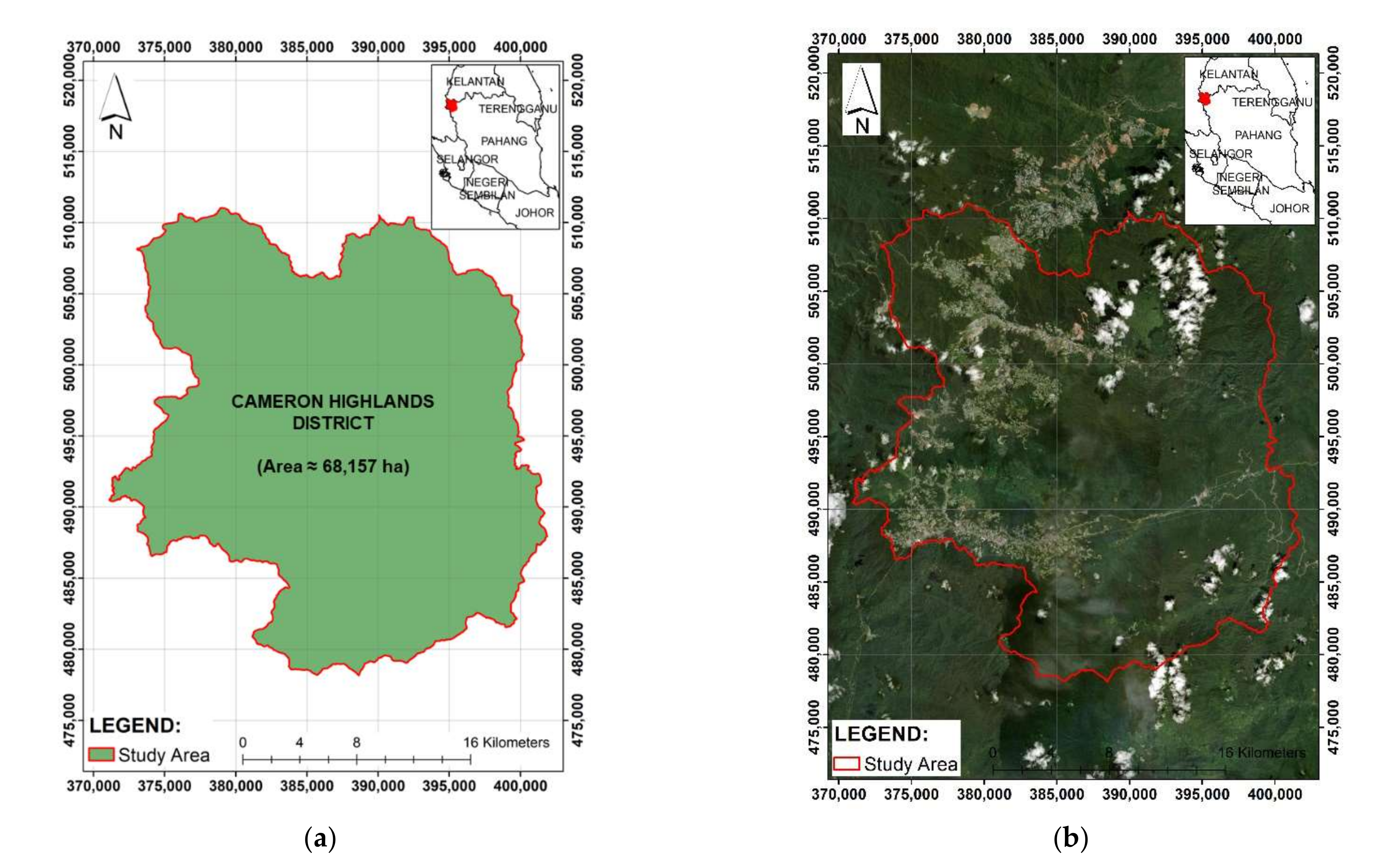
2.1. Study Area
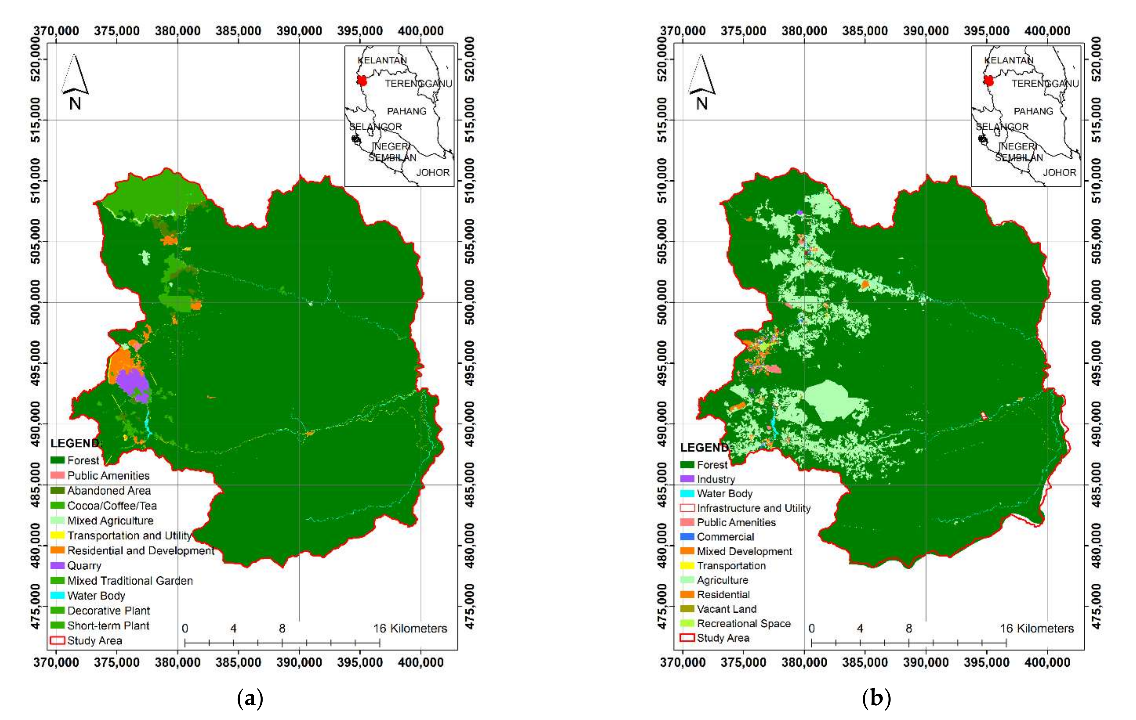
2.2. Land Use Information
3. Methods and Procedures
3.1. Methodology
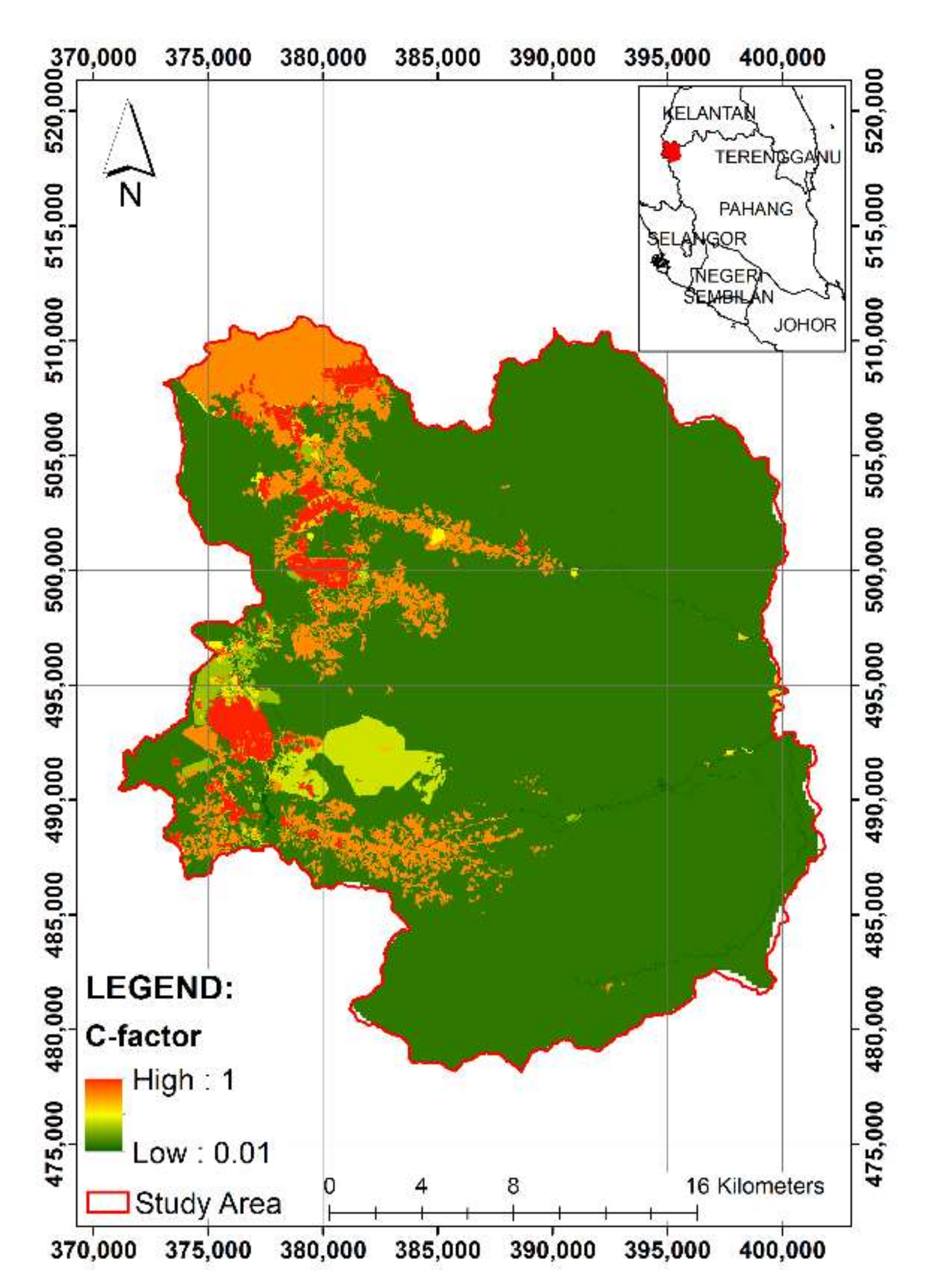
3.2. New Cover and Land Management Factors
4. Results and Discussion
5. Conclusions
Author Contributions
Funding
Institutional Review Board Statement
Informed Consent Statement
Data Availability Statement
Acknowledgments
Conflicts of Interest
References
- Parveen, R.; Kumar, U. Integrated Approach of Universal Soil Loss Equation (USLE) and Geographical Information System (GIS) for Soil Loss Risk Assessment in Upper South Koel Basin, Jharkhand. J. Geogr. Inf. Syst. 2012, 4, 588–596. [Google Scholar] [CrossRef] [Green Version]
- Vijith, H.; Seling, L.W.; Dodge-Wan, D. Estimation of Soil Loss and Identification of Erosion Risk Zones in a Forested Region in Sarawak, Malaysia, Northern Borneo. Environ. Dev. Sustain. 2018, 20, 1365–1384. [Google Scholar] [CrossRef]
- Samat, N.; Mahamud, M.A. Urbanisation in the George Town Conurbation and Its Impact to the Environment. Int. J. Environ. Eng. 2018, 9, 240–253. [Google Scholar] [CrossRef]
- Noh, N.S.M.; Sidek, L.M.; Wayayok, A.; Abdullah, A.F.; Basri, H.; Farhan, S.A.; Sulaiman, T.; Md Ariffin, A.B. Erosion and Sediment Control Best Management Practices in Agricultural Farms for Effective Reservoir Sedimentation Management at Cameron Highlands. Int. J. Recent Technol. Eng. 2019, 8, 6025–6198. [Google Scholar]
- Raj, J. Land Use Changes, Soil Erosion and Decreased Base Flow of Rivers at Cameron Highlands, Peninsular Malaysia. Bull. Geol. Soc. Malays. 2002, 45, 3–10. [Google Scholar] [CrossRef]
- Razali, A.; Syed Ismail, S.N.; Awang, S.; Praveena, S.M.; Zainal Abidin, E. Land Use Change in Highland Area and Its Impact on River Water Quality: A Review of Case Studies in Malaysia. Ecol. Process 2018, 7, 19. [Google Scholar] [CrossRef] [Green Version]
- Akale, A.T.; Dagnew, D.C.; Belete, M.A.; Tilahun, S.A.; Mekuria, W.; Steenhuis, T.S. Impact of Soil Depth and Topography on the Effectiveness of Conservation Practices on Discharge and Soil Loss in the Ethiopian Highlands. Land 2017, 6, 78. [Google Scholar] [CrossRef] [Green Version]
- Badmos, B.K.; Agodzo, S.K.; Villamor, G.B.; Odai, S.N. An Approach for Simulating Soil Loss from an Agro-Ecosystem Using Multi-Agent Simulation: A Case Study for Semi-Arid Ghana. Land 2015, 4, 607–626. [Google Scholar] [CrossRef] [Green Version]
- Kuok, K.; Mah, D.; Chiu, P. Evaluation of C and P Factors in Universal Soil Loss Equation on Trapping Sediment: Case Study of Santubong River. J. Water Resour. Prot. 2013, 5, 1149–1154. [Google Scholar] [CrossRef] [Green Version]
- Panagos, P.; Borrelli, P.; Meusburger, K.; van der Zanden, E.H.; Poesen, J.; Alewell, C. Modelling the effect of support practices (P-factor) on the reduction of soil erosion by water at European scale. Environ. Sci. Policy 2015, 51, 23–34. [Google Scholar] [CrossRef]
- Karydas, C.G.; Sekuloska, T.; Silleos, G.N. Quantification and site-specification of the support practice factor when mapping soil erosion risk associated with olive plantations in the Mediterranean island of Crete. Environ. Monit. Assess. 2009, 149, 19–28. [Google Scholar] [CrossRef] [PubMed]
- Tian, P.; Zhu, Z.; Yue, Q.; He, Y.; Zhang, Z.; Hao, F.; Guo, W.; Chen, L.; Liu, M. Soil erosion assessment by RUSLE with improved P factor and its validation: Case study on mountainous and hilly areas of Hubei Province, China. Int. Soil Water Conserv. Res. 2021, 9, 433–444. [Google Scholar] [CrossRef]
- Mittelstet, A.R.; Storm, D.E.; White, M.J. Using SWAT to enhance watershed-based plans to meet numeric water quality standards. Biol. Syst. Eng. Pap. Publ. 2016, 386, 5–21. [Google Scholar] [CrossRef] [Green Version]
- Mittelstet, A.R.; Storm, D.E.; Fox, G.A. Testing of the modified streambank erosion and instream phosphorus routines for the SWAT model. J. Am. Water Resour. Assoc. 2017, 53, 101–114. [Google Scholar] [CrossRef]
- Department of Irrigation and Drainage Malaysia—DID. Guideline for Erosion and Sediment Control in Malaysia; DID: Lumpur, Malaysia, 2010. [Google Scholar]
- Fatemeh, H.; Safwan, M.; Karam, A.; Glory, O.E.; Ahmad, H.; Hazem, G.A.; Jesús, R.C. CMIP5 climate projections and RUSLE-based soil erosion assessment in the central part of Iran. Sci. Rep. 2021, 11, 7273. [Google Scholar]
- Stefanos, S.; Vasileios, A.; Chrysoula, C.; Panagiotis, S. Assessing soil loss by water erosion in a typical Mediterranean ecosystem of Northern Greece under current and future rainfall erosivity. Water 2021, 13, 2002. [Google Scholar] [CrossRef]
- Stefanidis, S.; Chatzichristaki, C.; Stefanidis, P. An ArcGIS toolbox for estimation and mapping soil erosion. J. Environ. Prot. Ecol. 2021, 22, 689–696. [Google Scholar]
- AbdelRahman, M.A.E.; Natarajan, A.; Hegde, R.; Prakash, S.S. Assessment of land degradation using comprehensive geostatistical approach and remote sensing data in GIS-model builder. Egypt. J. Remote Sens. Space Sci. 2019, 22, 323–334. [Google Scholar] [CrossRef]
- Panos, P.; Cristiano, B.; Mihaly, H.; Simone, S.; Francis, M.; Mariia, B.; Jean, P.; Pasquale, B. Projections of soil loss by water erosion in Europe by 2050. Environ. Sci. Policy 2021, 124, 380–392. [Google Scholar]
- Department of Agriculture—DOA. Land-Use Activities 2015; Department of Agriculture Malaysia: Putrajaya Federal Territory, Malaysia, 2015. [Google Scholar]
- Department of Survey and Mapping Malaysia—JUPEM. Digital Elevation Model 2020; JUPEM: Kuala Lumpur, Malaysia, 2020. [Google Scholar]
- Google Earth. Cameron Highlands, Malaysia. Available online: https://earth.google.com/web/@4.47212375,101.38014488,-86101.14525661a,162789.78635436d,35y,0h,0t,0r?utm_source=earth7&utm_campaign=vine&hl=en (accessed on 20 November 2021).
- Department of Town and Country Planning Malaysia—PLANMalaysia. Land-Use Activities 2018; PLANMalaysia: Putrajaya Federal Territory, Malaysia, 2018. [Google Scholar]
- Layfield, Erosion Management Factors 2009. Available online: https://www.layfieldgroup.com/Geosynthetics/Tech-Notes/Erosion-Mgmt-Factors.aspx (accessed on 11 November 2020).
- Troeh, F.R.; Hobbs, J.A.; Donahue, R.L. Soil and Water Conservation: Productivity and Environment Protection; Prentice-Hall: Hoboken, NJ, USA, 1999. [Google Scholar]
- ECTC. Guidelines for Rolled Erosion Control Products; Erosion Control Technology Council: St. Paul, MN, USA, 2003. [Google Scholar]
- SCS. Urban Hydrology for Small Watersheds; Tech. Release No. 55; Soil Conservation Service, U.S.D.A.: Washington, DC, USA, 1986. [Google Scholar]
- UNEP; RIVM; ISRIC. A Qualitative Assessment of Water Erosion Risk Using 1:5 M SOTER Data; An Application for Northern Argentina South-East Brazil and Uruguay; Report 96/04; ISRIC: Wageningen, The Netherlands, 1996. [Google Scholar]
- Israelsen, C.E.; Clyde, C.G.; Fletcher, J.E.; Israelsen, E.K.; Haws, F.W.; Packer, P.E.; Farmer, E.E. Erosion control during highway construction. In Manual on Principles and Practices; National Cooperative Highway Research Program Report 221; Transportation Research Board, National Research Council: Washington, DC, USA, 1980. [Google Scholar]
- Wischmeier, W.H.; Smith, D.D. Predicting Rainfall Erosion Losses—A Guide to Conservation Planning; Agricultural Handbook No. 537; USDA: Washington, DC, USA, 1978. [Google Scholar]
- Kuenstler, W. C Factor: Cover-Management. 2009. Available online: www.techtransfer.osmre.gov/NTTMainSite/Library/hbmanual/rusle/chapter5.pdf (accessed on 11 November 2020).
- River Engineering and Urban Drainage Research Centre, Universiti Sains Malaysia—REDAC USM. Research of Preparation Erosion and Sediment Control Plan (ESCP) Guidelines for Logging and Plantation Agriculture in Malaysia; National Water Research Institute of Malaysia (NAHRIM): Kuala Lumpur, Malaysia, 2020. [Google Scholar]
- Musgrave, G.W. The quantitative evaluation of factors in water erosion: A first approximation. J. Soil Water Conserv. 1947, 2, 133–138. [Google Scholar]


| DOAM (2015) | PLANMalaysia (2018) | ||||
|---|---|---|---|---|---|
| Land-Use | Area (ha) | Percentage | Land-Use | Area (ha) | Percentage |
| Forest | 62,600.1306 | 91.85 | Forest | 59,788.6463 | 87.88 |
| Water Body | 253.8581 | 0.37 | Water Body | 263.3853 | 0.39 |
| Public Amenities | 34.6962 | 0.05 | Public Amenities | 162.8356 | 0.24 |
| Residential and Development | 692.5808 | 1.02 | Residential | 351.8190 | 0.52 |
| Quarry | 455.8169 | 0.67 | Industry | 20.9987 | 0.03 |
| Transportation and Utility | 264.3966 | 0.39 | Infrastructure and Utility | 28.3891 | 0.04 |
| Abandoned Area | 476.5986 | 0.70 | Transportation | 43.2753 | 0.06 |
| Mixed Agriculture | 154.7226 | 0.23 | Commercial | 61.4781 | 0.09 |
| Mixed Traditional Garden | 3.5818 | 0.01 | Mixed Development | 1.3571 | 0.00 |
| Cocoa/Coffee/Tea | 201.5902 | 0.30 | Recreational Space | 57.6358 | 0.08 |
| Decorative Plant | 79.2568 | 0.12 | Agriculture | 7212.9312 | 10.60 |
| Short-Term Plant | 2939.5144 | 4.31 | Vacant Land | 43.2777 | 0.06 |
| Total | 68,156.7436 | 100.00 | Total | 68,156.7436 | 100.00 |
| Cover Management | C Factor |
|---|---|
| Quarrying Areas | 1.00 |
| Forest | |
| 25% Cover | 0.42 |
| 50% Cover | 0.39 |
| 75% Cover | 0.36 |
| 100% Cover | 0.03 |
| Agricultural Areas | |
| Agricultural Plants | 0.38 |
| Horticulture/Traditional Mixed Plants | 0.25 |
| Cocoa/Tea/Coffee | 0.20 |
| Coconut/Oil Palm/Rubber | 0.20 |
| Paddy | 0.01 |
| Flower/Fruit | 0.30 |
| Urbanized Areas | |
| Residential | |
| Low Density (50% Green Area) | 0.25 |
| Medium Density (25% Green Area) | 0.15 |
| High Density (5% Green Area) | 0.05 |
| Commercial, Industrial and Educational | |
| Low Density (50% Green Area) | 0.25 |
| Medium Density (25% Green Area) | 0.15 |
| High Density (5% Green Area) | 0.05 |
| Impervious (Parking Lot, Road, etc.) | 0.01 |
| Water Body | 0.01 |
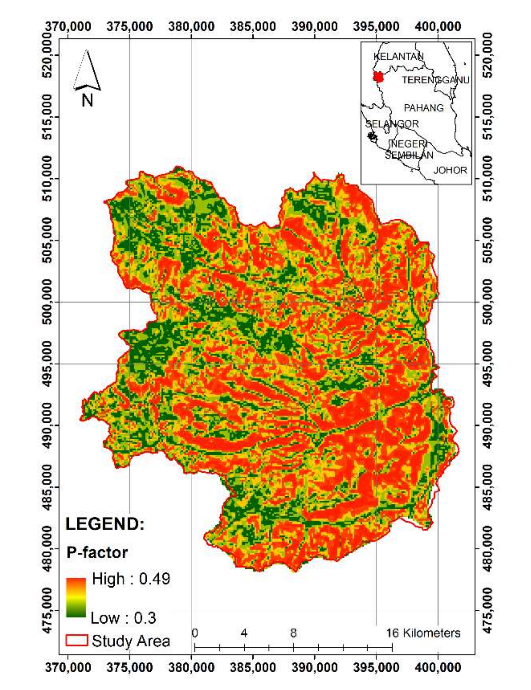
| Land Management | P Factor | |
|---|---|---|
| Bare Soil | 1.00 | |
| Wired Log/Sandbag Barriers | 0.85 | |
| Contour Furrowed Surface (Maximum Length Refers to Downslope Length) | ||
| Slope (%) | Max. Length | |
| 1 to 2 | 120 | 0.60 |
| 3 to 5 | 90 | 0.50 |
| 6 to 8 | 60 | 0.50 |
| 9 to 12 | 40 | 0.60 |
| 13 to 16 | 25 | 0.70 |
| 17 to 20 | 20 | 0.80 |
| >20 | 15 | 0.80 |
| Terracing | ||
| Slope (%) | ||
| 1 to 2 | 0.12 | |
| 3 to 8 | 0.10 | |
| 9 to 12 | 0.12 | |
| 13 to 16 | 0.14 | |
| 17 to 20 | 0.16 | |
| >20 | 0.18 | |
| Soil Loss (A)-Factor (tons/ha/year) | Category |
|---|---|
| ≤10 | Low |
| 11–25 | Moderate |
| 26–50 | High |
| 51–100 | Very High |
| ≥101 | Critical |
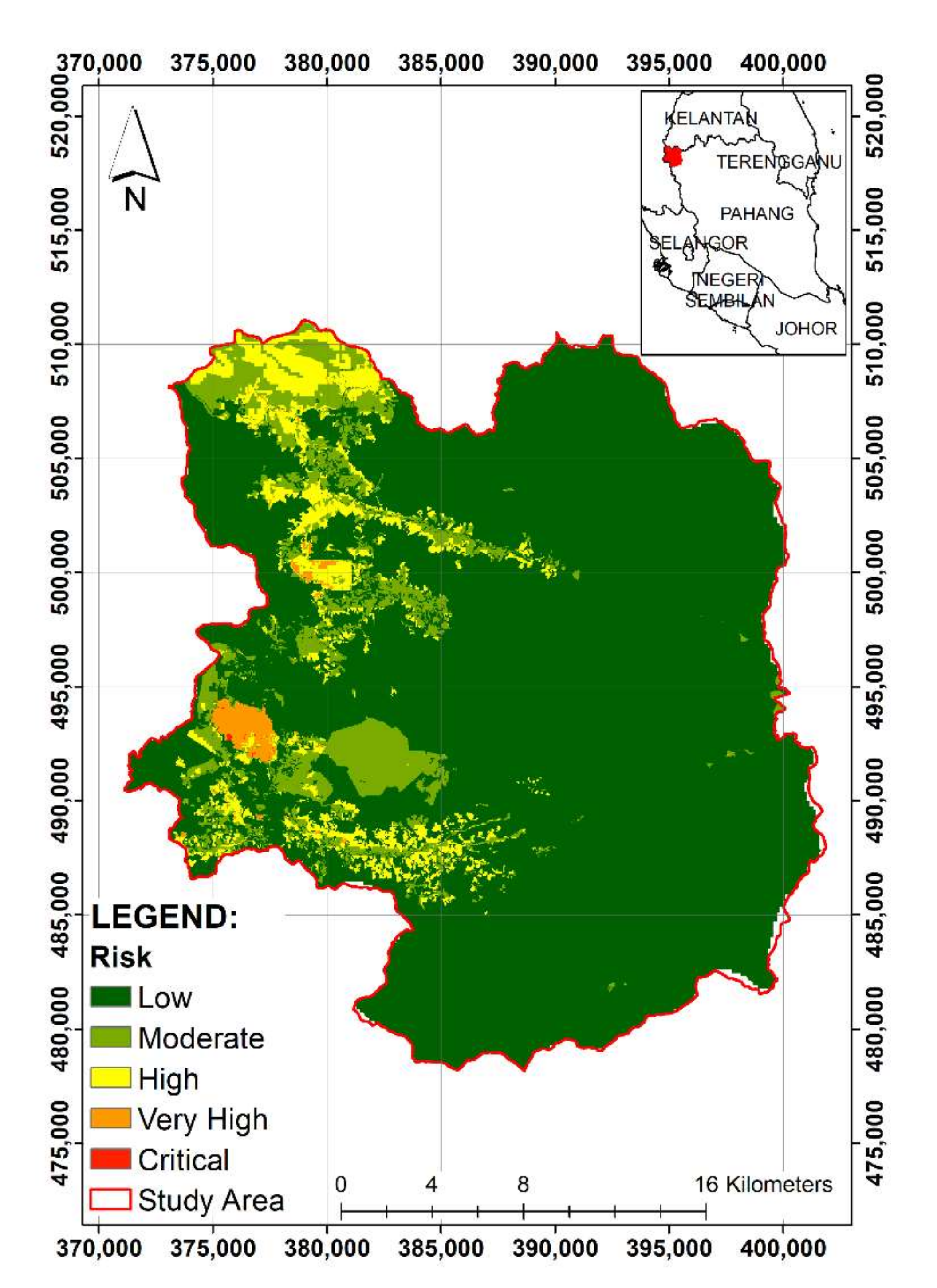
| District | Soil Loss Class Category | Risk (tons/ha/year) | Area (ha) | Percentage |
|---|---|---|---|---|
| Cameron Highlands | Low | ≤10 | 57,104.87 | 84.37 |
| Moderate | 11–25 | 6034.52 | 8.92 | |
| High | 26–50 | 3945.03 | 5.83 | |
| Very High | 51–100 | 589.66 | 0.87 | |
| Critical | ≥101 | 12.65 | 0.02 |
Publisher’s Note: MDPI stays neutral with regard to jurisdictional claims in published maps and institutional affiliations. |
© 2021 by the authors. Licensee MDPI, Basel, Switzerland. This article is an open access article distributed under the terms and conditions of the Creative Commons Attribution (CC BY) license (https://creativecommons.org/licenses/by/4.0/).
Share and Cite
Mahamud, M.A.; Saad, N.A.; Zainal Abidin, R.; Yusof, M.F.; Zakaria, N.A.; Mohd Amiruddin Arumugam, M.A.R.; Mat Desa, S.; Md. Noh, M.N. Determination of Cover and Land Management Factors for Soil Loss Prediction in Cameron Highlands, Malaysia. Agriculture 2022, 12, 16. https://doi.org/10.3390/agriculture12010016
Mahamud MA, Saad NA, Zainal Abidin R, Yusof MF, Zakaria NA, Mohd Amiruddin Arumugam MAR, Mat Desa S, Md. Noh MN. Determination of Cover and Land Management Factors for Soil Loss Prediction in Cameron Highlands, Malaysia. Agriculture. 2022; 12(1):16. https://doi.org/10.3390/agriculture12010016
Chicago/Turabian StyleMahamud, Mohd Amirul, Noor Aida Saad, Roslan Zainal Abidin, Mohd Fazly Yusof, Nor Azazi Zakaria, Mohd Aminur Rashid Mohd Amiruddin Arumugam, Safari Mat Desa, and Md. Nasir Md. Noh. 2022. "Determination of Cover and Land Management Factors for Soil Loss Prediction in Cameron Highlands, Malaysia" Agriculture 12, no. 1: 16. https://doi.org/10.3390/agriculture12010016