Review

A Brief Review of Machine Learning Algorithms in Forest Fires Science

1
Physical Geography, Institute of Geographical Sciences, Free University Berlin, Malteserstraße 74-100, 12449 Berlin, Germany
2
College of Computer & Information Systems, Umm al Qura University, Makkah 24382, Saudi Arabia
*
Author to whom correspondence should be addressed.
Appl. Sci. 2023, 13(14), 8275; https://doi.org/10.3390/app13148275
Submission received: 31 May 2023 / Revised: 13 July 2023 / Accepted: 14 July 2023 / Published: 17 July 2023
(This article belongs to the Special Issue Feature Review Papers in "Earth Sciences and Geography" Section)

Abstract

:
Due to the harm forest fires cause to the environment and the economy as they occur more frequently around the world, early fire prediction and detection are necessary. To anticipate and discover forest fires, several technologies and techniques were put forth. To forecast the likelihood of forest fires and evaluate the risk of forest fire-induced damage, artificial intelligence techniques are a crucial enabling technology. In current times, there has been a lot of interest in machine learning techniques. The machine learning methods that are used to identify and forecast forest fires are reviewed in this article. Selecting the best forecasting model is a constant gamble because each ML algorithm has advantages and disadvantages. Our main goal is to discover the research gaps and recent studies that use machine learning techniques to study forest fires. By choosing the best ML techniques based on particular forest characteristics, the current research results boost prediction power.

1. Introduction

Forest fires are a ubiquitous and vital component of the Earth’s system [1], and it is a year-round worldwide phenomenon that happens each month (Figure 1). According to [2], the current estimate of the annual worldwide area burned is around 420 Mha, which is more than the area of India. Grasslands and savannas account are the areas most affected by forest fires. People start over 90% of forest fires, and flash of lightning is to blame for most of the leftover ignitions. Humans may suffer severe effects from forest fires, directly through fatalities and community devastation or indirectly through smoke and ash inhalation [3].
Forest fires have ramifications for global warming and the survival of flora and fauna [3]. Early fire prediction and identification are crucial to limit damage and reduce firefighting efforts. Millions are spent annually on fire management efforts to reduce or stop forest fires [3]. Therefore, it is essential to comprehend forest fires and their triggers and to improve forest fire prediction in several vital areas of forest fire management.
Two main measures are to be taken to prevent forest fires. The first is forest fire incidence prediction, which essentially forecasts the forest fire eruption likelihood earlier in its early ignition by modeling the relationship between the fire risk and significant factors, for example, fuel content or weather conditions. The second measure is forest fire detection, which involves identifying and locating existing active fires. The primary goal is to offer precise localization and a fire alarm early, before the fire spreads over a vast region and becomes uncontrollable.
Although fire activity can be measured on various scales (centimeters to kilometers, seconds to millennia), it does face some limitations. For instance, combustion and fire formerly are physicochemical processes that may be effectively signified at relatively fine scales in mechanistic models [4]. Nevertheless, the capacity to resolve important physical processes and availability of input data and the quality frequently constrain such models [5]. Furthermore, due to restraints associated with present processing capacity, it is impossible to use physical models to influence research and fire management at bigger and longer scales that are occasionally required in near real-time. Thus, forest fire management and science strongly rely on creating empirical and statistical models. For meso-, synoptic-, strategic-, and global-scale phenomena [6], the value of which is contingent on their capacity to capture the frequently complicated and nonlinear interactions between variables of interest, in addition to data availability, including data quality.
Although the intricacies of forest fires sometimes create modeling issues, significant breakthroughs in forest fire observation and monitoring have been accomplished, mainly due to the capabilities and increased availability of remote-sensing technology. Several satellites (NASA, TERRA, and AQUA) contain onboard fire detection sensors (Advanced Very High-Resolution, Radiometer (AVHRR), Visible Infrared Imaging Radiometer Suite (VIIRS), and Moderate Resolution Imaging Spectroradiometer (MODIS)). These sensors regularly monitor changes and vegetation distributions. Furthermore, advances in numerical weather prediction and climate models provide lesser geographical resolutions and lengthier lead forecast times [7], potentially improving forecasting of intense fire weather occurrences. Given enough data, such advancements make a data-centric approach to forest fire modeling a natural progression for many research challenges. As a result, there has been a surge in attention to applying machine learning methods in forest fire management and science in current years.
Despite the lack of a formal definition, we embrace the ordinary meaning of ML as the study of computer algorithms that can improve themselves spontaneously via experience [8]. This method is inherently data-centric, with ML algorithm success determined by the quality and amount of accessible data relevant to the job. In recent years, ML has grown rapidly in the context of data analysis and computing, which typically allows the applications to function in an intelligent manner. AI researchers seek to comprehend and synthesize intelligent beings capable of acting in accordance with their circumstances and aims, adapting to changing surroundings, and learning from experience [9]. A previous work [10] outlined the incentives for employing AI for forested ecosystem-related research, including disruptions caused by forest fire, insects, and disease. Ref. [11] suggested using ML approaches to represent complex problems in ecology. Current reviews in the geosciences [12], extreme weather prediction [13], forest ecology [14], flood forecasting [15], statistical downscaling [16], remote sensing [17], and water resources, show that the use of ML models is effective [18,19]. Two current viewpoints have also presented persuasive cases for the use of deep learning in Earth system studies and for combating climate change [20,21]. However, studies still need to consolidate the various ML techniques employed in the diverse difficulties confronting forest fire research.

2. Artificial Intelligence and Machine Learning

New technologies are typically designed to make the process more manageable, precise, quicker, or less expensive. They also allow us to do or develop previously unattainable jobs in certain circumstances. One of the most quickly expanding scientific procedures for practical use in recent years has been (AI).
ML is an AI application in which data-trained algorithms produce AI. Artificial intelligence and machine learning have grown in popularity over the last decade thanks to significant advancements in computer technology [22]. This popularity has resulted in dramatic advancements in the capacity to gather and analyze enormous amounts of data.

2.1. ML Technologies

Machine learning is a collection of methodologies, tools, and computer algorithms that teach machines to analyze, comprehend, and discover hidden patterns in data to make predictions. The ultimate objective of machine learning is to use data for self-learning, removing the need to train computers explicitly. Machines trained on datasets can apply learned patterns to new data and generate better predictions [23]. The most popular ML methods fall into three groups: Reinforcement learning, supervised learning, and unsupervised learning [24,25].
Supervised learning: Machines are taught to solve problems with the help of humans, who gather and identify data and then “feed” it to systems. A computer is given specific data features to examine to detect patterns, classify items, and assess whether its prediction is correct or incorrect [26].
Unsupervised learning: Methods are primarily concerned with grouping/clustering uncategorized data. In this learning category, machines learn to spot patterns and trends in unlabeled data without anyone being overseen by humans [27].
Reinforcement learning: In a confined setting foreign to them, models must solve a problem through a series of tries and mistakes. Machines are punished for errors and rewarded for good trials, similar to a scenario in many games. They learn to find the best answer this way [28].
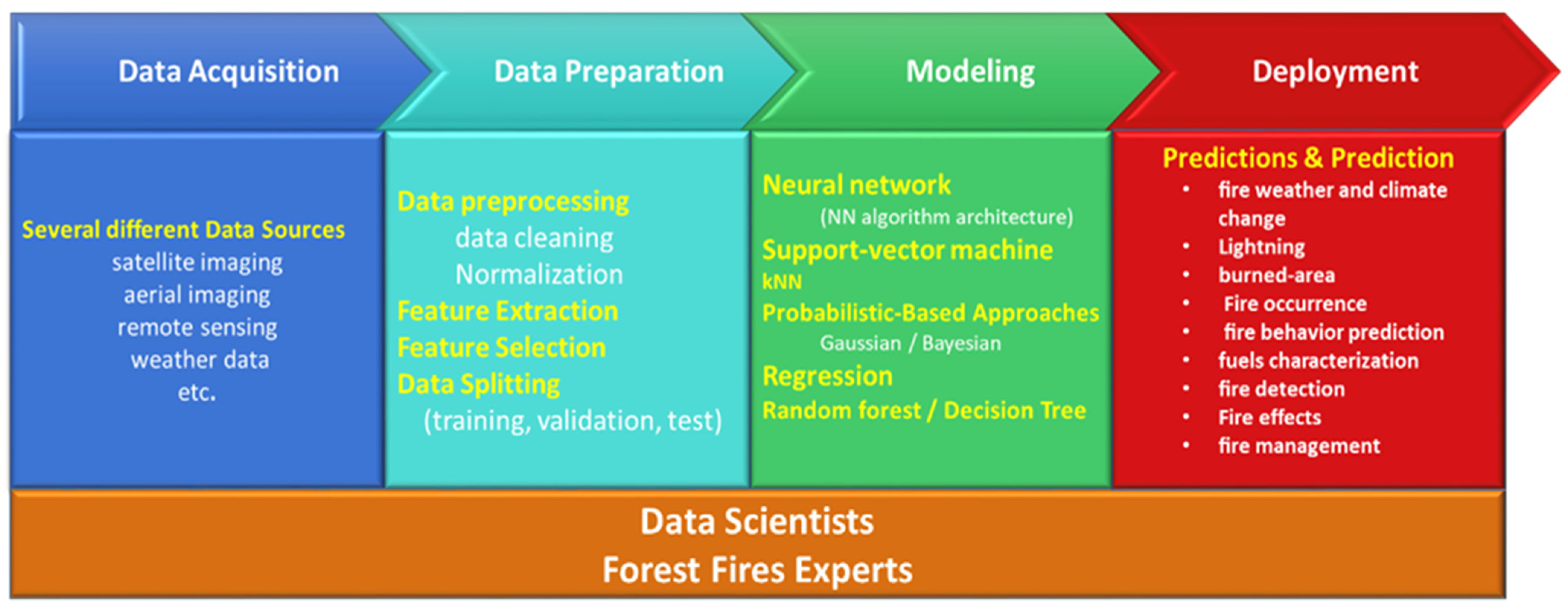
2.2. ML Process

The standard procedure for analyzing DATA by machine learning comprises many steps (Figure 2) Gathering data and choosing appropriate characteristics, building machine learning models, and assessing the target systems [29].
All machine learning algorithms rely on data, which is essential for developing correct ML models. As is well known, the amount of data is crucial, and it is commonly assumed that adding more data will improve the accuracy of ML models. Even though this is often true, data quality is not insignificant and should also be considered. Data sets with insufficient or low-quality data (e.g., data that is difficult to recreate or contains significant mistakes) might result in incorrect ML predictions, biasing the related result interpretation. In this scenario, the first step in developing a credible ML model is to create a data set that reflects the topic under consideration. The process of cleaning and altering raw data before processing and analyzing is known as data preparation. It is a critical stage before processing that frequently involves reformatting data, making changes, and integrating data sets to enrich data. The original data may then be turned into samples to train the ML model after feature engineering and data cleaning (including selection and feature extraction). The modeling stage addresses the core ML objectives of developing a model that meets the project’s goals given a high-quality dataset with appropriate attributes. The first three phases are Algorithm Selection, Hyperparameter Optimization, and Training, in which an ML algorithm is selected, set up, and run to build a model. The above three stages can be combined to form the challenge of Combined Algorithm Search and Hyperparameter Optimization or Full Model Selection. Numerous iterations complete the problem, with additional modifications to the dataset being required. The feedback loops between data preparation and modeling are critical elements to depict these iterations.
The diagnosis process is an addition to the standard approaches that bridge the gap between a model’s performance and understanding, given that the results of a successful ML project should be understandable to domain experts. Finally, professionals and researchers can utilize these models to assure the accessibility of the findings obtained; we consider the purpose of deployment as making the resultant model available to the application’s end-user.

2.3. Deep Learning (DL)

Deep learning is a branch of machine learning that takes inspiration from the structure of the human brain, often referred to as artificial neural networks. Its objective is to develop computer systems capable of learning patterns and gaining insights from data, enabling them to make predictions or decisions in a manner similar to humans. Unlike traditional machine learning algorithms, deep learning algorithms utilize multiple layers of processing. Each layer serves as a model trained on data, with the output of one layer serving as input for the next. This multi-layered approach allows deep learning algorithms to identify complex patterns and gain deeper insights from data compared to traditional machine learning algorithms [28]. There exists a variety of deep learning algorithms, among which some of the most well-known are convolutional neural networks (CNNs), recurrent neural networks (RNNs), and generative adversarial networks (GANs). CNNs, in particular, are widely employed in fire detection systems, primarily for detecting the presence of fires in images. The deep learning approach has also been explored in forest fire prediction systems, with CNNs being extensively utilized to address this specific issue [30].

3. Review of ML Technologies and Their Applications in Forest Fire Science

There are several studies in the literature discussing the use of machine learning in forest fire science [31,32,33]. Here, we review publications relevant to forest fires that investigate and employ machine learning approaches in multiple domains of application.

3.1. Fire Detection

There have been several studies aimed at early fire detection in forest fires since fire detection is an important area. There is growing interest in the use of newer technologies in fire detection, such as machine and deep learning. Here are some methods that have been proposed by research works.
In order to design a false alarm reduction system, ref. [34] conducted a study to evaluate multi-source data, such as metrological geographic information, as well as visual and infrared camera data. A detection rate of over 98% and a false alarm rate of 1.93% were achieved by the study, which used WSN approaches in conjunction with the Backpropagation Network (BPN), Radial Base Function Network (RBFN), Dynamic Learning Vector Quantization (DLVQ), and MLP.
By assessing the Canadian FWI system’s forest fire features and residential fire temperature Ionization Photoelectric CO gas, ref. [35] performed data analysis for the detection of forest fires and residential fires. Distributed ANN and Naive Bayes were both used to analyze these data. The accuracy of home fire detection in their study was 81%, whereas the accuracy of forest fire detection was 92%.
Ref. [36] used UAV-based aerial images as their data to detect forest fires using a Convolution neural network (CNN). Their study had an 83% preference accuracy.
The study’s goal was to self-organize and fault-tolerate the WSN model for forest fire detection, which they achieved by evaluating meteorological data using the DT method [37]. Their study failed detection of about 45% of possible failure identification in the application.
Ref. [38] evaluated 17 fire films using FLURIA, OneR, and NN as classifiers in a study to detect video-based fire. Their research produced an SVM of 90.9%.
Ref. [39] conducted a study similar to [36], in which they used the same classifier to detect forest fires. However, they switched to aerial 360-degree imagery, which resulted in higher performance accuracy (94%). Ref. [40] study aimed to detect forest fires using UAV by analyzing thermal camera data using the Multilayer NN method. Their research findings are not available.
Ref. [41] used MLP with WSN as classifiers to analyze a dataset made up of relative temperature, humidity, smoke, and wind speed in order to detect forest fires in real-time. An average communication load ratio of 2.5% to 8% was found in their investigation, both with and without the use of the NN technique.
Using a fuzzy unordered rule induction algorithm (FURIA), NN, and OneR, ref. [42] conducted a study comparing data mining approaches on WSN-based fire detection systems. They arrived at their conclusions by assessing various combinations of temperature, humidity, light, and CO. Three percentages of occurrences were accurately classified as a consequence of their study: FURIA: 87.6, OneR: 71.6, and NN: 93.8%.
In order to identify fire using a data fusion system, ref. [43] did a comparison study. To do this, they evaluated temperature, humidity, light intensity, and CO using fuzzy logic in the WSN approach. They did not have any outcomes for their study.
Ref. [44] looked into a CNN camera-based fire detection model that has been fine-tuned through the analysis of CCTV security cameras. Their investigation’s accuracy, precision, recall, and F-measure were 94.3%, 0.82, 0.98, and 0.89, respectively. According to [45], the study aimed to detect forest fires by evaluating fire and fire-like object videos using the Rule-Based image processing algorithm. For their study, recall was 93.13%, precision was 92.59, F-score was 92.86, and the false detection rate was less than 40%.
Ref. [46] study’s goal was to detect fires with fuzzy logic and a home monitoring system, which they achieved by evaluating temperature, humidity, CO, and smoke in the WSN method with fuzzy logic. Their study yielded a 6.67% error ratio.
The study’s goal was to detect forest fires using multi-sensor WSN, which they accomplished by evaluating temperature, humidity, smoke, and light sensors using the Naive Bayes method [47]. Their study had a 94% accuracy rate.
Ref. [48] investigated fire detection using UAV imagery as their data and evaluated it using the deep convolutional NN, which had a performance accuracy of more than 95%.
Ref. [49] aim to identify a dominant combustion phase in real-time by evaluating smoke, CO2, and temperature with an MLP classifier. Their research yields an accuracy of 82.5%.
Ref. [50] used deep CNN and SVM to evaluate fire photos in order to evaluate their experiment’s goal of detecting fire occurrences in photographs. Their research produced two accuracy levels: Patch locations (SVM 92.2% and CNN 93.2%) and global image-level testing with Deep CNN with 90% accuracy.

3.2. Fire Prediction

Disaster preparedness depends on predicting forest fires. Novel forest fire prediction technology would, therefore, enable better management of forest fires. This domain has been successfully tackled through the use of machine learning and deep learning methods. Some methods suggested by research works are listed below.
According to Arpaci [51], the study evaluated topology, infrastructure, and socioeconomic data before using the RF predictor to forecast fire. Their research produced an accuracy rate of 78%.
The chance of a fire occurring was explored by [52] using a Bayesian analysis of data based on eyesight. A false positive rate of 0.68% and a false negative rate of 0.028% were found in their study.
In order to forecast fire ignition, ref. [53] used logistic regression to analyze terrain, vegetation kinds, meteorological conditions, climate, and human activities. Their research produced an accuracy rate of 85.7%.
Ref. [54] used MLP and fuzzy logic techniques to analyze multi-sensor data, temperature, smoke density, and CO density in order to predict fire likelihood. The error value from their study was 10−4.
The ignition probability prediction of a forest fire was made using a model created by analyzing data from raster GIS, including the date of occurrence, geographic coordinates, cause of ignition, land use, and burned areas [55]. These data were evaluated using logistic regression and MLP as experimental techniques. Their findings included ANN accuracy of 75.5% with ignition and 87.8% without ignition, as well as logistic regression accuracy of 78.8% with ignition and 74% without ignition.
Research on chosen and prioritized biotic, abiotic, and human factors that affect forest fire activity was done by [56]. They used the BNN approach to analyze a satellite-based fire dataset (MODIS) for their investigation. A recall of 0.963, a specificity of 072, and an accuracy of 0.961 were obtained from their study.
Ref. [57] used the CNN method to evaluate landscaping, fuel types, and weather conditions in order to predict the time-resolved spatial evolution of a forest fire. Their research produced a mean precision of 97%, sensitivity of 925, and an F-measure of 93%.
Ref. [58] used the LSTM classifier to evaluate weather and forest fire data to predict the forest fire scale, which performed with 90.9% accuracy.
Ref. [59] found that using weather, location, and time to predict forest fires using a fuzzy inference system was 75% accurate.
By employing the CART technique to assess environmental characteristics such vegetation status, accessibility, fire history, and topography, ref. [60] sought to identify the occurrence of fire in certain models. The accuracy of their study was 88.39%.
In their study, ref. [61] evaluated the NDVI composite MODIS data using the Multilayer feedforward networks (MLFN) as the classifier to determine the high-risk FFD based on information in the pixels of multi-temporal satellite pictures. The accuracy and MSE values of their investigation were 90% and 0.07, respectively.
Ref. [62] used Random Forest (RF) Multiple Linear Regression to evaluate 37 variables taken from multiple databases spanning diverse features in order to develop models of fire occurrence likelihood and the contributing factors (MLR). According to the RF classifier, their investigation produced a total price-fire season variable of 93.31% and 179% for no-fire season. The MLR processor’s metrics for the no-fire season variable and the fire season variable were, respectively, 49.193 and 22.15.
In order to study human-caused fire occurrence modeling, ref. [63] employed logistic regression to assess weather information, regional traits, and historical records of daily fire. Their research produced an accurate range for the total proportion of accurately anticipated fires of 47.4% to 82.6%.
Ref. [64] used the Boosted regression tree classifier to mask a forest fire’s susceptibility. They assessed using two satellite images (OLI and MODIS), yielding an accuracy of 0.89.
Ref. [65] investigate the establishment of forest fire susceptibility by evaluating topographical, meteorological, and geological data using BRT, GAM, and RF methods. Their research yielded three inaccuracies (BRT: 80, 74; RF: 72, 79; GAM: 87, 70).
Ref. [66] investigated the occurrence of fire forecasting by analyzing weather data with the auto-learn framework, achieving an accuracy of 87%.
Using three classifiers, ref. [67] evaluated the following data: Socioeconomic, economic activity, and fire-causing potential (LR, SVM, RF). Their research had a 74.6% performance accuracy and was intended to investigate the frequency of human-caused forest fires.
A study by [68] uses several machine learning models to predict the spread and behavior of forest fires using a dataset collected from Brazilian government open data. Their research yielded the following findings: AdaBoost model accuracy is 91%, RF model accuracy is 88%, ANN model accuracy is 86%, and SVM model accuracy is 81%.
Weather observations were used by [69] to forecast the Fire weather index. The NN predictor was utilized, and the performance error rate was 9%.
Ref. [70] conducted a study to predict the occurrence and size of forest fires, which they accomplished by analyzing a monthly resolution global dataset of burned areas in 0.25° 0.25° regions around the entire globe for the year 2015 using multiple ML models such as random forest, XGBoost, multilayer perceptron, and logistic and linear regressions. Their study yielded an XGBoost accuracy of 94%, logistic regression accuracy of 81%, RF accuracy of 89%, and MLP accuracy of 90%.
By analyzing GIS data, multi-temporal MODIS data, and meteorological ALADIN data using the BT, RF, Logistic regression, Naive Bayesian (NB), and SVM algorithms, ref. [71] were able to predict forest fires. The outcomes of their research were as follows: 84.9% accuracy for BT, 82.5% accuracy for RF, 83% accuracy for logistic regression, 81% accuracy for NB, and 83% accuracy for SVM.
Ref. [72] predicted the danger of forest fires using the same data as [59]. They did, however, use a different predictor, the DFP-MnBpAnn. A study by [72] has a higher performance accuracy of 89%.
In a study on predicting the factors’ significance in a fire initiation threat scheme, ref. [73] used MLP and BPA to analyze meteorological data, vegetation, and topological human presence data. According to their research, the following factors (PI) had the highest percentages of influence: 35.9% rainfall in the previous 24 h, 1028.7% temperature, 60.3% fuel moisture (10 h), 16.9% aspect, 17.3% primary road network, and 14.3% for the month of the year.
Ref. [74] conducted a comparative study of ANN and logistic regression models in the context of human-caused fire prediction systems. They evaluated spatially differentiated data managed in a Geographical Information System and applied logistic regression (RBFN) as a method. Their study yielded an ANN accuracy of 85% for no-fire correct prediction.
In a study by [75], a combination of locally weighted learning (LWL) algorithm with ensemble learning techniques, such as Cascade Generalization (CG), Bagging, Decorate, and Dagging, was employed to predict forest fire susceptibility in the Pu Mat National Park, Nghe An Province, Vietnam. The training process involved utilizing a geospatial database containing 56 historical fire records and nine explanatory variables to train the standalone LWL model as well as its derived ensemble models. To assess the models’ performance and predictive capability, several statistical performance criteria were employed, including the area under the receiver operating characteristic curve (AUC). The CG-LWL and Bagging-LWL models exhibited the highest training performance, with an AUC of 0.993. Furthermore, the Dagging-LWL ensemble model, with an AUC of 0.983, outperformed the Decorate-LWL (AUC = 0.976), CG-LWL and Bagging-LWL (AUC = 0.972), and standalone LWL (AUC = 0.965) models in predicting the spatial pattern of fire susceptibilities across the study area.

3.3. Fire Mapping

ML methods have been relatively recently introduced in fire mapping studies in comparison to other fields. However, these studies have already incorporated a diverse range of ML methods. Below are some of the methods recommended by research studies:
Ref. [76] used UAV imagery as research data to map fire severity. Their experiment employed the Random Forest Classifier, which achieved a performance accuracy of 89%.
Using the logistic regression method and GIS-based data, ref. [77] carried out a study to map the fire ignition risk based on human activities and presence factors. Their research yielded a global accuracy of 79.8%, an ignition prediction accuracy of 78.2%, and an ignition prediction accuracy of 82.7%.
In their study, ref. [78] used the SVM method to analyze meteorological data in order to identify burned areas that they had reached. The MAD and RMES predictions were 13.07 and 64.7, respectively. Their study’s performance has a 12.7% error rate.
Ref. [79] did a study with the goal of creating a map of the susceptibility of forests to fires. To do this, they used BPN to evaluate GIS-based data. Their research produced a 78% agreement.
On the study site, ref. [80] assessed fire severity mapping using Sentinel satellite imagery and a Random Forest classifier. Their study performed admirably, with a 98% accuracy level.
Ref. [81] mapped the burned areas using Landsat Thematic Mapper imagery (TM). With a performance accuracy of more than 93%, they have identified it using SVM and nine additional classifiers.
Ref. [82] used spectral bands (MODIS) as data assessed by the supervised minimum distance classifier to map the burned areas with 90% accuracy.
Ref. [83] investigated the spatial performance of forest fires by evaluating the weather, vegetation, and infrastructure using the MARS-DFP classifier. The study was completed with an accuracy of 86.5%.
In a study by [84], five hybrid machine learning algorithms were developed to map forest fire susceptibility in the northern region of Morocco. These algorithms are Frequency Ratio-Multilayer Perceptron, Frequency Ratio-Logistic Regression, Frequency Ratio-Classification and Regression Tree, Frequency Ratio-Support Vector Machine, and Frequency Ratio-Random Forest. The mapping process involved utilizing a dataset consisting of 510 historic forest fire points as the forest fire inventory map and ten independent causal factors, including elevation, slope, aspect, distance to roads, distance to residential areas, land use, normalized difference vegetation index, rainfall, temperature, and wind speed. To evaluate the models’ effectiveness, the area under the receiver operating characteristics curves (AUC) was computed. The results revealed that the Frequency Ratio-Random Forest model achieved the highest performance with an AUC of 0.989, followed by Frequency Ratio-Support Vector Machine with an AUC of 0.959, Frequency Ratio-Multilayer Perceptron with an AUC of 0.858, Frequency Ratio-Classification and Regression Tree with an AUC of 0.847, and Frequency Ratio-Logistic Regression with an AUC of 0.809 in predicting forest fire occurrences.

3.4. Evaluating Data Collected from Forest Fires

Datasets have played a pivotal role in driving progress and fostering innovation in machine learning research. They enable the evaluation and comparison of model performance. As the availability of extensive forest fire datasets continues to increase, there is a significant opportunity to utilize ML and DL methods that can efficiently extract relevant features from the data. Here are some studies covering several datasets and ML methods in forest fire domain.
The CNN method was used in a study by [85] to evaluate the IRIS dataset. There were no reported outcomes.
A study by [86] employed the R-CNN method to evaluate data from the ConFoBi project. Their analysis produced a precision of 43.4% and a precision of 92.4%.
The CNN method was used in a study by [87] to evaluate images captured by a drone. There were no published findings from the study.
The YOLOv3 method was used in a study by [88] to evaluate drone videos. Their study had an 82% precision, 79% recall, and a FI score of 81%.
In a study by [89], the Bi-CNN method was used to evaluate the YUPENN, BUAA, and Maryland datasets. Their research yielded a mean accuracy of 93%.
A study by [90] compared the UAV dataset Kaggle, drone images, and open-source photos using the DenseNet121, Resnet52, and MobilNetv2 networks. Their research yielded a DenseNet accuracy of 93.1%.
A study by [91] used DenseNet121, Resnet52, and MobilNetv2 to evaluate COCODataset. Their research yielded a mobile net accuracy of 87.5%.
Ref. [92] evaluated images created with the CycleGan and DenseNet methods. The study’s results were 99.38% precision, 98.16% FI-Score, and 98.27% accuracy.
A study by [93] used CNN and RNBFE methods to evaluate the UCM and WHU RS datasets. Their research yielded UCM accuracy of 97.84% and WHU accuracy of 97%.
The FLAME dataset was evaluated using the CNN and UNet methods in a study by [94]. Their research yielded CLA accuracy of 76.23%, SEG recall of 83.88%, precision of 91.99%, and a FI score of 87.75%.
A study by [95] used UNet++ and UNet methods to evaluate data collected from a forest fire in Andong, Republic of Korea, on April 20. Their study yielded specificities of 91.77% and 83.11%.
A study by [96] used mobile net V3 and YOLOv4 methods to evaluate MSCOCO and collect images. Their research yielded 99.21% recall, 99.21% precession, 99.57% accuracy, and 75.68% interference time reduction.
A study by [97] used Mobile Net v2, CNN, FireNet, and AlexNet methods to evaluate 2096 images collected from the internet. The study yielded 2.5M parameters with a 99.3% accuracy.
A study by [98] employed FireNet to evaluate images from Google on Baida and the AInML lab dataset (DCNN). Their study had a 98% accuracy rate.
A study by [99] evaluated drone images using the author’s model as the method. Their research yielded an accuracy of 81.97%.
In a study by [100], seven ML approaches were employed to assess active fire pixels obtained from MODIS monthly MCD14ML composites. The ML approaches utilized were Logistic Regression, SVM, Linear Discriminant Analysis, as well as ensemble algorithms, such as eXtreme Gradient Boosting, Random Forest, Gradient Boosting, and AdaBoost (AB). Five performance metrics, namely average accuracy, F1 score, precision, recall, and area under the curve, were employed for evaluation. The AUC values ranged from 0.817 to 0.879 across the seven methods, while accuracy scores ranged between 0.734 and 0.812. The results indicated that the RF model consistently outperformed the other approaches across all performance metrics.

4. Discussion

In this section, we discuss some suggestions and significant challenges of integrating ML and forest fire science, as well as identify several research priorities for the future. The benefits of powerful, efficient ML methods in forest fire science and management are widely anticipated. We examined some considerations for using ML methods in forest fires in our review of studies, including data considerations, model selection, and accuracy, and which forest fire domains have been used.
To develop forest fire resilience, it is essential to mention that big data measurement and analysis connected to fire occurrences and forecast of fire events require a more robust framework involving the government and populations living nearby fire-prone expanses. More research is needed to investigate such frameworks based on community social media interactions and crowdsourced event sensing.
Cloud computing platforms have been developed to provide computational and data storage resources to cope with these massive datasets, particularly remote sensing big data, which have caused significant issues. The large volume, high spatial-temporal resolution, and complexity cause these problems. In any case, data processing and administration are critical in making use of substantial geographic datasets. Google Earth Engine (GEE) is one of the most promising and practical solutions for analyzing remote sensing big data. It provides access to the most freely available, multi-temporal remote sensing data, and offers scalable, cloud-based computational power for geospatial data analysis. These remote sensing data can be imported and processed rapidly on the cloud platform, eliminating the requirement to download data to local computers for processing [101,102].
GEE provides various RS algorithms for image enhancement, image classification, and cloud masking. These algorithms can be used to improve the quality of images by reducing noise or improving accuracy. These algorithms are easily access customizable and accessible and enable data processing and visualization at various scales via JavaScript or Python Application Program Interfaces (APIs) [103,104,105,106]. These capabilities eliminate most of the time-consuming preparation processes required in traditional RS techniques.
ML is a data-centric modeling paradigm that can be used to detect patterns in data. It is best suited for problems with sufficient high-quality data. However, this tool only comes into play when the situation calls for it, which is not always the case. To address the fundamental issue of data scarcity while eliminating human error, we might construct new synthetic data instances where training a forest fire detection model with synthetic datasets enhances model performance [107].
In forest fire domains, where most ML applications use some type of imaging, remote sensing plays a crucial role in data collection [108]. Although continued advances in remote sensing have increased the availability of large spatiotemporal datasets, not all satellite images have good resolution. In addition, weather may not be stable in all situations as it varies, resulting in noisy images. UAVs can collect high-resolution photos of the forest. They can give additional frequent and precise pictures of the forest canopy than ground-based imaging due to their excellent mobility and ability to cover large regions at minimal expense [109]. As a result, more accurate fire location detection is achievable than satellite photography. As a result, the combination of UAVs and machine learning could be highly effective for detecting forest fires in their early stages. It can also be beneficial for transmitting critical information to relevant authorities via efficient communication technology [110]. These features of UAVs make them effective as a solution for the real-time detection of forest fires utilizing UAV footage in various light and weather conditions.
Due to their superior performance compared to traditional image recognition methods, deep learning algorithms have become increasingly popular in the last decade for using spatial features to help identify and predict fire behavior. This has resulted in a sharp rise in the application of deep learning for forest fires applications. Deep learning has the advantage of learning numerous layers of representations for data, which can better capture the complicated structure of data and increase pattern recognition performance compared to typical machine learning approaches.

5. Conclusions

This research reviewed several studies proposed for integrating machine learning techniques in forest fire science. According to the papers examined, developing advanced systems incorporating artificial intelligence is a promising direction that forecasts such significant environmental issues and helps public policies in the prevention of forest fires. Machine learning in forest fire science poses disadvantages—ML systems, which require a large amount of data to train, are frequently unavailable during forest fires. Next, ML learning approaches require a large amount of computing power, which can be expensive and difficult to scale. Finally, the accuracy of ML learning system predictions in the real world may be challenging to evaluate. Furthermore, while ML models can learn independently, expertise in forest fire research is required to provide realistic modeling of forest fire processes through many scales. The complexity of some ML methods needs devoted and sophisticated knowledge of their application. This study aims to provide scholars with an overview of the state-of-the-art in the threat of forest fires, which is still an open subject.

Author Contributions

Conceptualization, R.A. and W.S.; methodology, R.A., W.S. and B.S.; formal analysis, R.A., W.S. and A.A.; investigation, R.A. and W.S.; resources, R.A. and A.A.; data curation, W.S. and A.A.; writing—original draft preparation, R.A., A.A. and B.S.; writing—review and editing, W.S. and B.S.; visualization, R.A. and A.A.; supervision, B.S.; project administration, W.S. and B.S.; funding acquisition, B.S. All authors have read and agreed to the published version of the manuscript.

Funding

Publication fund for this is supported by Free University Berlin.

Institutional Review Board Statement

Not Applicable.

Informed Consent Statement

Not Applicable.

Data Availability Statement

Not Applicable.

Conflicts of Interest

The authors declare no conflict of interest.

References

  1. Bond, W.; Keeley, J. Fire as a global ‘herbivore’: The ecology and evolution of flammable ecosystems. Trends Ecol. Evol. 2005, 20, 387–394. [Google Scholar]
  2. Giglio, L.; Boschetti, L.; Roy, D.P.; Humber, M.L.; Justice, C.O. The Collection 6 MODIS burned area mapping algorithm and product. Remote Sens. Environ. 2018, 217, 72–85. [Google Scholar] [CrossRef]
  3. Borrelli, P.; Armenteras, D.; Panagos, P.; Modugno, S.; Schütt, B. The Implications of Fire Management in the Andean Paramo: A Preliminary Assessment Using Satellite Remote Sensing. Remote Sens. 2015, 7, 11061–11082. [Google Scholar] [CrossRef] [Green Version]
  4. Coen, J. Some Requirements for Simulating Wildland Fire Behavior Using Insight from Coupled Weather—Wildland Fire Models. Fire 2018, 1, 6. [Google Scholar] [CrossRef] [Green Version]
  5. Hoffman, C.M.; Canfield, J.; Linn, R.R.; Mell, W.; Sieg, C.H.; Pimont, F.; Ziegler, J. Evaluating Crown Fire Rate of Spread Predictions from Physics-Based Models. Fire Technol. 2016, 52, 221–237. [Google Scholar] [CrossRef] [Green Version]
  6. Simard, S. Fire Severity, Changing Scales, and How Things Hang Together. Int. J. Wildland Fire 1991, 1, 23. [Google Scholar] [CrossRef]
  7. Bauer, P.; Thorpe, A.; Brunet, G. The quiet revolution of numerical weather prediction. Nature 2015, 525, 47–55. [Google Scholar] [CrossRef] [PubMed]
  8. Mitchell, T.M. Machine Learning; McGraw-Hill: New York, NY, USA, 1997. [Google Scholar]
  9. Poole, D.L.; Mackworth, A.K. Artificial Intelligence; Cambridge University Press: Cambridge, UK, 2010. [Google Scholar]
  10. Schmoldt, D.L. Application of Artificial Intelligence to Risk Analysis for Forested Ecosystems; Springer: Berlin/Heidelberg, Germany, 2001; pp. 49–74. [Google Scholar]
  11. Olden, J.; Lawler, J.; Poff, N. Machine Learning Methods Without Tears: A Primer for Ecologists. Q. Rev. Biol. 2008, 83, 171–193. [Google Scholar] [CrossRef] [Green Version]
  12. Karpatne, A.; Ebert-Uphoff, I.; Ravela, S.; Babaie, H.A.; Kumar, V. Machine Learning for the Geosciences: Challenges and Opportunities. IEEE Trans. Knowl. Data Eng. 2019, 31, 1544–1554. [Google Scholar] [CrossRef] [Green Version]
  13. McGovern, A.; Elmore, K.L.; Gagne, D.J.; Haupt, S.E.; Karstens, C.D.; Lagerquist, R.; Smith, T.; Williams, J.K. Using Artificial Intelligence to Improve Real-Time Decision-Making for High-Impact Weather. Bull. Am. Meteorol. Soc. 2017, 98, 2073–2090. [Google Scholar] [CrossRef]
  14. Liu, Z.; Peng, C.; Work, T.; Candau, J.-N.; DesRochers, A.; Kneeshaw, D. Application of machine-learning methods in forest ecology: Recent progress and future challenges. Environ. Rev. 2018, 26, 339–350. [Google Scholar] [CrossRef] [Green Version]
  15. Mosavi, A.; Ozturk, P.; Chau, K.-w. Flood Prediction Using Machine Learning Models: Literature Review. Water 2018, 10, 1536. [Google Scholar] [CrossRef] [Green Version]
  16. Vandal, T.; Kodra, E.; Ganguly, A.R. Intercomparison of machine learning methods for statistical downscaling: The case of daily and extreme precipitation. Theor. Appl. Climatol. 2019, 137, 557–570. [Google Scholar] [CrossRef] [Green Version]
  17. Lary, D.J.; Alavi, A.H.; Gandomi, A.H.; Walker, A.L. Machine learning in geosciences and remote sensing. Geosci. Front. 2016, 7, 3–10. [Google Scholar] [CrossRef] [Green Version]
  18. Shen, C. A Transdisciplinary Review of Deep Learning Research and Its Relevance for Water Resources Scientists. Water Resour. Res. 2018, 54, 8558–8593. [Google Scholar] [CrossRef]
  19. Sun, A.Y.; Scanlon, B.R. How can Big Data and machine learning benefit environment and water management: A survey of methods, applications, and future directions. Environ. Res. Lett. 2019, 14, 073001. [Google Scholar] [CrossRef]
  20. Reichstein, M.; Camps-Valls, G.; Stevens, B.; Jung, M.; Denzler, J.; Carvalhais, N.; Prabhat. Deep learning and process understanding for data-driven Earth system science. Nature 2019, 566, 195–204. [Google Scholar] [CrossRef]
  21. Rolnick, D.; Donti, P.L.; Kaack, L.H.; Kochanski, K.; Lacoste, A.; Sankaran, K.; Ross, A.S.; Milojevic-Dupont, N.; Jaques, N.; Waldman-Brown, A.; et al. Tackling Climate Change with Machine Learning. ACM Comput. Surv. 2023, 55, 1–96. [Google Scholar] [CrossRef]
  22. Joshi, A.V. Machine Learning and Artificial Intelligence, 2nd ed.; Springer: Berlin/Heidelberg, Germany, 2023. [Google Scholar]
  23. Wassouf, W.N.; Alkhatib, R.; Salloum, K.; Balloul, S. Predictive analytics using big data for increased customer loyalty: Syriatel Telecom Company case study. J. Big Data 2020, 7, 29. [Google Scholar] [CrossRef] [Green Version]
  24. Hall, O.; Ohlsson, M.; Rögnvaldsson, T. A review of explainable AI in the satellite data, deep machine learning, and human poverty domain. Patterns 2022, 3, 100600. [Google Scholar] [CrossRef]
  25. Jain, P.; Coogan, S.C.P.; Subramanian, S.G.; Crowley, M.; Taylor, S.; Flannigan, M.D. A review of machine learning applications in wildfire science and management. Environ. Rev. 2020, 28, 478–505. [Google Scholar] [CrossRef]
  26. Florath, J.; Keller, S. Supervised Machine Learning Approaches on Multispectral Remote Sensing. Remote. Sens. 2022, 14, 657. [Google Scholar] [CrossRef]
  27. Wang, J.; Miao, Y.-Q.; Khamis, A.M.; Karray, F.; Liang, J. Adaptation Approaches in Unsupervised Learning: A Survey of the. In Proceedings of the Image Analysis and Recognition—13th International Conference, ICIAR, Póvoa de Varzim, Portugal, 13–15 July 2016; Volume 9730, pp. 3–11. [Google Scholar]
  28. Arulkumaran, K.; Deisenroth, M.P.; Brundage, M.; Bharath, A.A. Deep Reinforcement Learning: A Brief Survey. IEEE Signal Process. Mag. 2017, 34, 26–38. [Google Scholar] [CrossRef] [Green Version]
  29. Shobha, G.; Rangaswamy, S. Machine Learning; Elsevier: Amsterdam, The Netherlands, 2018; pp. 197–228. [Google Scholar]
  30. Yandouzi, M.; Grari, M.; Idrissi, I.; Moussaoui, O.; Azizi, M.; Ghoumid, K.; Aissa, K.E. Review On Forest Fires Detection And Prediction Using Deep Learning And Drones. J. Theor. Appl. Inf. Technol. 2022, 100, 4565–4576. [Google Scholar]
  31. Abid, F. A Survey of Machine Learning Algorithms Based Forest Fires Prediction and Detection Systems. Fire Technol. 2021, 57, 559–590. [Google Scholar] [CrossRef]
  32. Arif, M.; Alghamdi, K.K.; Sahel, S.A.; Alosaimi, S.O.; Alsahafi, M.E.; Alharthi, M.A.; Arif, M. Role of Machine Learning Algorithms in Forest Fire Management: A Literature Review. J. Robot. Autom. 2021, 5, 212–226. [Google Scholar]
  33. Bayat, G.; Yıldız, K. Comparison of the Machine Learning Methods to Predict Wildfire Areas. Turk. J. Sci. Technol. 2022, 17, 241–250. [Google Scholar] [CrossRef]
  34. Arrue, B.; Ollero, A.; Matinez de Dios, J. An intelligent system for false alarm reduction in infrared forest-fire detection. IEEE Intell. Syst. 2000, 15, 64–73. [Google Scholar] [CrossRef] [Green Version]
  35. Bahrepour, M.; van der Zwaag, B.J.; Meratnia, N.; Havinga, P. Fire Data Analysis and Feature Reduction Using Computational Intelligence Methods; Springer: Berlin/Heidelberg, Germany, 2010; pp. 289–298. [Google Scholar]
  36. Jiao, Z.; Zhang, Y.; Xin, J.; Mu, L.; Yi, Y.; Liu, H.; Liu, D. A Deep Learning Based Forest Fire Detection Approach Using UAV and YOLOv3. In Proceedings of the 2019 1st International Conference on Industrial Artificial Intelligence (IAI), Shenyang, China, 23–27 July 2019; Volume 7, pp. 1–5. [Google Scholar]
  37. Giuntini, F.T.; Beder, D.M.; Ueyama, J. Exploiting self-organization and fault tolerance in wireless sensor networks: A case study on wildfire detection application. Int. J. Distrib. Sens. Netw. 2017, 13, 155014771770412. [Google Scholar] [CrossRef]
  38. Habiboğlu, Y.H.; Günay, O.; Çetin, A.E. Covariance matrix-based fire and flame detection method in video. Mach. Vis. Appl. 2012, 23, 1103–1113. [Google Scholar] [CrossRef]
  39. Barmpoutis, P.; Stathaki, T.; Dimitropoulos, K.; Grammalidis, N. Early Fire Detection Based on Aerial 360-Degree Sensors, Deep Convolution Neural Networks and Exploitation of Fire Dynamic Textures. Remote Sens. 2020, 12, 3177. [Google Scholar] [CrossRef]
  40. Kinaneva, D.; Hristov, G.; Raychev, J.; Zahariev, P. Early Forest Fire Detection Using Drones and Artificial Intelligence. In Proceedings of the 2019 42nd International Convention on Information and Communication Technology, Electronics and Microelectronics (MIPRO), Opatija, Croatia, 20–24 May 2019; pp. 1060–1065. [Google Scholar]
  41. Yu, L.; Wang, N.; Meng, X. Real-time forest fire detection with wireless sensor networks. In Proceedings of the 2005 International Conference on Wireless Communications, Networking and Mobile Computing, Wuhan, China, 26 September 2005; pp. 1214–1217. [Google Scholar]
  42. Maksimović, M.; Vujović, V. Comparative Analysis of Data Mining Techniques Applied to Wireless Sensor Network Data for Fire Detection. JITA-APEIRON 2013, 6. [Google Scholar] [CrossRef] [Green Version]
  43. Manjunatha, P.; Verma, A.; Srividya, A. Multi-Sensor Data Fusion in Cluster based Wireless Sensor Networks Using Fuzzy Logic Method. In Proceedings of the 2008 IEEE Region 10 and the Third international Conference on Industrial and Information Systems, Kharagpur, India, 8–10 December 2008; Volume 12, pp. 1–6. [Google Scholar]
  44. Muhammad, K.; Ahmad, J.; Baik, S.W. Early fire detection using convolutional neural networks during surveillance for effective disaster management. Neurocomputing 2018, 288, 30–42. [Google Scholar] [CrossRef]
  45. Mahmoud, M.A.I.; Ren, H. Forest Fire Detection Using a Rule-Based Image Processing Algorithm and Temporal Variation. Math. Probl. Eng. 2018, 2018, 7612487. [Google Scholar] [CrossRef] [Green Version]
  46. Saputra, F.A.; Rasyid, M.U.H.A.; Abiantoro, B.A. Prototype of early fire detection system for home monitoring based on Wireless Sensor Network. In Proceedings of the 2017 International Electronics Symposium on Engineering Technology and Applications (IES-ETA), Surabaya, Indonesia, 26–27 September 2017; Volume 9, pp. 39–44. [Google Scholar]
  47. Saoudi, M.; Bounsafceur, A.; Euler, R.; Kechadi, T. Data Mining Techniques Applied to Wireless Sensor Networks for Early Forest Fire Detection. In Proceedings of the International Conference on Internet of things and Cloud Computing, Cambridge, UK, 22–23 March 2016; Volume 3, pp. 1–7. [Google Scholar]
  48. Lee, W.; Kim, S.; Lee, Y.-T.; Lee, H.-W.; Choi, M. Deep neural networks for wild fire detection with unmanned aerial vehicle. In Proceedings of the 2017 IEEE International Conference on Consumer Electronics (ICCE), Las Vegas, NV, USA, 8–10 January 2017; pp. 252–253. [Google Scholar]
  49. Yan, X.; Cheng, H.; Zhao, Y.; Yu, W.; Huang, H.; Zheng, X. Real-Time Identification of Smoldering and Flaming Combustion Phases in Forest Using a Wireless Sensor Network-Based Multi-Sensor System and Artificial Neural Network. Sensors 2016, 16, 1228. [Google Scholar] [CrossRef] [Green Version]
  50. Zhang, Q.; Xu, J.; Xu, L.; Guo, H. Deep Convolutional Neural Networks for Forest Fire Detection. In 2016 International Forum on Management, Education and Information Technology Application; Atlantis Press: Amsterdam, The Netherlands, 2016. [Google Scholar]
  51. Arpaci, A.; Malowerschnig, B.; Sass, O.; Vacik, H. Using multi variate data mining techniques for estimating fire susceptibility of Tyrolean forests. Appl. Geogr. 2014, 53, 258–270. [Google Scholar] [CrossRef]
  52. Borges, P.V.K.; Izquierdo, E. A Probabilistic Approach for Vision-Based Fire Detection in Videos. IEEE Trans. Circuits Syst. Video Technol. 2010, 20, 721–731. [Google Scholar] [CrossRef]
  53. Chang, Y.; Zhu, Z.; Bu, R.; Chen, H.; Feng, Y.; Li, Y.; Hu, Y.; Wang, Z. Predicting fire occurrence patterns with logistic regression in Heilongjiang Province, China. Landsc. Ecol. 2013, 28, 1989–2004. [Google Scholar] [CrossRef]
  54. Chen, S.; Bao, H.; Zeng, X.; Yang, Y. A fire detecting method based on multi-sensor data fusion. In Proceedings of the SMC’03 Conference Proceedings. 2003 IEEE International Conference on Systems, Man and Cybernetics, Conference Theme—System Security and Assurance (Cat. No.03CH37483), Washington, DC, USA, 8 October 2003; Volume 4, pp. 3775–3780. [Google Scholar]
  55. De Vasconcelos, M.J.P.; Silva, S.; Tome, M.; Alvim, M.; Pereira, J.C. Spatial prediction of fire ignition probabilities: Comparing logistic regression and neural networks. Photogramm. Eng. Remote Sens. 2001, 67, 73–81. [Google Scholar]
  56. Dlamini, W.M. A Bayesian belief network analysis of factors influencing wildfire occurrence in Swaziland. Environ. Model. Softw. 2010, 25, 199–208. [Google Scholar] [CrossRef]
  57. Hodges, J.L.; Lattimer, B.Y. Wildland Fire Spread Modeling Using Convolutional Neural Networks. Fire Technol. 2019, 55, 2115–2142. [Google Scholar] [CrossRef]
  58. Liang, H.; Zhang, M.; Wang, H. A Neural Network Model for Wildfire Scale Prediction Using Meteorological Factors. IEEE Access 2019, 7, 176746–176755. [Google Scholar] [CrossRef]
  59. Lin, H.; Liu, X.; Wang, X.; Liu, Y. A fuzzy inference and big data analysis algorithm for the prediction of forest fire based on rechargeable wireless sensor networks. Sustain. Comput. Inform. Syst. 2018, 18, 101–111. [Google Scholar] [CrossRef]
  60. Lozano, F.J.; Suárez-Seoane, S.; Kelly, M.; Luis, E. A multi-scale approach for modeling fire occurrence probability using satellite data and classification trees: A case study in a mountainous Mediterranean region. Remote Sens. Environ. 2008, 112, 708–719. [Google Scholar] [CrossRef]
  61. Maeda, E.E.; Formaggio, A.R.; Shimabukuro, Y.E.; Arcoverde, G.F.B.; Hansen, M.C. Predicting forest fire in the Brazilian Amazon using MODIS imagery and artificial neural networks. Int. J. Appl. Earth Obs. Geoinf. 2009, 11, 265–272. [Google Scholar] [CrossRef]
  62. Oliveira, S.; Oehler, F.; San-Miguel-Ayanz, J.; Camia, A.; Pereira, J.M. Modeling spatial patterns of fire occurrence in Mediterranean Europe using Multiple Regression and Random Forest. For. Ecol. Manag. 2012, 275, 117–129. [Google Scholar] [CrossRef]
  63. Padilla, M.; Vega-García, C. On the comparative importance of fire danger rating indices and their integration with spatial and temporal variables for predicting daily human-caused fire occurrences in Spain. Int. J. Wildland Fire 2011, 20, 46. [Google Scholar] [CrossRef]
  64. Pourghasemi, H.R.; Gayen, A.; Lasaponara, R.; Tiefenbacher, J.P. Application of learning vector quantization and different machine learning techniques to assessing forest fire influence factors and spatial modelling. Environ. Res. 2020, 184, 109321. [Google Scholar] [CrossRef]
  65. Pourtaghi, Z.S.; Pourghasemi, H.R.; Aretano, R.; Semeraro, T. Investigation of general indicators influencing on forest fire and its susceptibility modeling using different data mining techniques. Ecol. Indic. 2016, 64, 72–84. [Google Scholar] [CrossRef]
  66. Qu, J.; Cui, X. Automatic machine learning Framework for Forest fire forecasting. J. Phys. Conf. Ser. 2020, 1651, 012116. [Google Scholar] [CrossRef]
  67. Rodrigues, M.; de la Riva, J. An insight into machine-learning algorithms to model human-caused wildfire occurrence. Environ. Model. Softw. 2014, 57, 192–201. [Google Scholar] [CrossRef]
  68. Rubí, J.N.; de Carvalho, P.H.; Gondim, P.R. Application of machine learning models in the behavioral study of forest fires in the Brazilian Federal District region. Eng. Appl. Artif. Intell. 2023, 118, 105649. [Google Scholar] [CrossRef]
  69. Safi, Y.; Bouroumi, A. Prediction of forest fires using Artificial neural networks. Appl. Math. Sci. 2013, 7, 271–286. [Google Scholar] [CrossRef]
  70. Shmuel, A.; Heifetz, E. Global Wildfire Susceptibility Mapping Based on Machine Learning Models. Forests 2022, 13, 1050. [Google Scholar] [CrossRef]
  71. Stojanova, D.; Panov, P.; Kobler, A.; Džeroski, S.; Taškova, K. Learning to predict forest fires with different data mining techniques. In Proceedings of the Conference on data mining and data warehouses (SiKDD 2006), Ljubljana, Slovenia, 2006; pp. 255–258. [Google Scholar]
  72. Tien Bui, D.; Le, H.V.; Hoang, N.-D. GIS-based spatial prediction of tropical forest fire danger using a new hybrid machine learning method. Ecol. Inform. 2018, 48, 104–116. [Google Scholar] [CrossRef]
  73. Vasilakos, C.; Kalabokidis, K.; Hatzopoulos, J.; Matsinos, I. Identifying wildland fire ignition factors through sensitivity analysis of a neural network. Nat. Hazards 2009, 50, 125–143. [Google Scholar] [CrossRef]
  74. Vega-Garcia, C.; Lee, B.S.; Woodard, P.M.; Titus, S.J. Applying Neural Network Technology to Human-Caused Wildfire Occurrence Prediction. AI Appl. 1996, 10, 9–18. [Google Scholar]
  75. Tuyen, T.; Jaafari, A.; Yen, H.; Nguyen-Thoi, T.; Phong, T.; Nguyen, H.; Van Le, H.; Phuong, T.T.M.; Nguyen, S.H.; Prakash, I. Mapping forest fire susceptibility using spatially explicit ensemble models based on the locally weighted learning algorithm. Ecol. Inform. 2021, 63, 101292. [Google Scholar] [CrossRef]
  76. Arkin, J.; Coops, N.C.; Hermosilla, T.; Daniels, L.D.; Plowright, A. Integrated fire severity–land cover mapping using very-high-spatial-resolution aerial imagery and point clouds. Int. J. Wildland Fire 2019, 28, 840. [Google Scholar] [CrossRef]
  77. Catry, F.X.; Rego, F.C.; Bação, F.L.; Moreira, F. Modeling and mapping wildfire ignition risk in Portugal. Int. J. Wildland Fire 2009, 18, 921. [Google Scholar] [CrossRef] [Green Version]
  78. Cortez, P.; Morais, A.d.J.R. A Data Mining Approach to Predict Forest Fires Using Meteorological Data; Associação Portuguesa para a Inteligência Artificial (APPIA): Guimarães, Portugal, 2007. [Google Scholar]
  79. Dimuccio, L.A.; Ferreira, R.; Cunha, L.; Campar de Almeida, A. Regional forest-fire susceptibility analysis in central Portugal using a probabilistic ratings procedure and artificial neural network weights assignment. Int. J. Wildland Fire 2011, 20, 776. [Google Scholar] [CrossRef]
  80. Gibson, R.; Danaher, T.; Hehir, W.; Collins, L. A remote sensing approach to mapping fire severity in south-eastern Australia using sentinel 2 and random forest. Remote Sens. Environ. 2020, 240, 111702. [Google Scholar] [CrossRef]
  81. Mallinis, G.; Koutsias, N. Comparing ten classification methods for burned area mapping in a Mediterranean environment using Landsat TM satellite data. Int. J. Remote Sens. 2012, 33, 4408–4433. [Google Scholar] [CrossRef]
  82. Mohler, R.L.; Goodin, D.G. Identifying a suitable combination of classification technique and bandwidth(s) for burned area mapping in tallgrass prairie with MODIS imagery. Int. J. Appl. Earth Obs. Geoinf. 2012, 14, 103–111. [Google Scholar] [CrossRef]
  83. Tien Bui, D.; Hoang, N.-D.; Samui, P. Spatial pattern analysis and prediction of forest fire using new machine learning approach of Multivariate Adaptive Regression Splines and Differential Flower Pollination optimization: A case study at Lao Cai province (Viet Nam). J. Environ. Manag. 2019, 237, 476–487. [Google Scholar] [CrossRef] [PubMed]
  84. Mohajane, M.; Costache, R.; Karimi, F.; Bao Pham, Q.; Essahlaoui, A.; Nguyen, H.; Laneve, G. Oudija, F. Application of remote sensing and machine learning algorithms for forest fire mapping in a Mediterranean area. Ecol. Indic. 2021, 129, 107869. [Google Scholar] [CrossRef]
  85. Georgiev, G.D.; Hristov, G.; Zahariev, P.; Kinaneva, D. Forest Monitoring System for Early Fire Detection Based on Convolutional Neural Network and UAV imagery. In Proceedings of the 2020 28th National Conference with International Participation (TELECOM), Sofia, Bulgaria, 29–30 October 2020; Volume 10, pp. 57–60. [Google Scholar]
  86. Bulatov, D.; Leidinger, F. Instance segmentation of deadwood objects in combined optical and elevation data using convolutional neural networks. Earth Resour. Environ. Remote Sens. GIS Appl. XII 2021, 9, 37. [Google Scholar]
  87. Allauddin, M.S.; Kiran, G.S.; Kiran, G.S.R.; Srinivas, G.; Mouli, G.U.R.; Prasad, P.V. Development of a Surveillance System for Forest Fire Detection and Monitoring using Drones. In Proceedings of the IGARSS 2019—2019 IEEE International Geoscience and Remote Sensing Symposium, Yokohama, Japan, 28 July–2 August 2019; Volume 7, pp. 9361–9363. [Google Scholar]
  88. Jiao, Z.; Zhang, Y.; Mu, L.; Xin, J.; Jiao, S.; Liu, H.; Liu, D. A YOLOv3-based Learning Strategy for Real-time UAV-based Forest Fire Detection. In Proceedings of the 2020 Chinese Con-trol and Decision Conference (CCDC), Hefei, China, 22–24 August 2020; Volume 8, pp. 4963–4967. [Google Scholar]
  89. Zheng, J.; Cao, X.; Zhang, B.; Huang, Y.; Hu, Y. Bi-heterogeneous Convolutional Neural Network for UAV-based dynamic scene classification. In Proceedings of the 2017 Integrated Communications, Navigation and Surveillance Conference (ICNS), Herndon, VA, USA, 18–20 April 2017; Volume 4, pp. 5–12. [Google Scholar]
  90. Lohit, G.V.S. Reforestation Using Drones and Deep Learning Techniques. In Proceedings of the 2021 7th International Conference on Advanced Computing and Communication Systems (ICACCS), Coimbatore, India, 19–20 March 2021; Volume 3, pp. 847–852. [Google Scholar]
  91. Lohit, G.V.S.; Bisht, D. Seed Dispenser using Drones and Deep Learning Techniques for Reforestation. In Proceedings of the 2021 5th International Conference on Computing Methodologies and Communication (ICCMC), Erode, India, 8–10 April 2021; Volume 4, pp. 1275–1283. [Google Scholar]
  92. Park, M.; Tran, D.Q.; Jung, D.; Park, S. Wildfire-Detection Method Using DenseNet and CycleGAN Data Augmentation-Based Remote Camera Imagery. Remote Sens. 2020, 12, 3715. [Google Scholar] [CrossRef]
  93. Rajagopal, A.; Ramachandran, A.; Shankar, K.; Khari, M.; Jha, S.; Lee, Y.; Joshi, G.P. Fine-Tuned Residual Network-Based Features with Latent Variable Support Vector Machine-Based Optimal Scene Classification Model for Unmanned Aerial Vehicles. IEEE Access 2020, 8, 118396–118404. [Google Scholar] [CrossRef]
  94. Shamsoshoara, A.; Afghah, F.; Razi, A.; Zheng, L.; Fulé, P.Z.; Blasch, E. Aerial imagery pile burn detection using deep learning: The FLAME dataset. Comput. Netw. 2021, 193, 108001. [Google Scholar] [CrossRef]
  95. Tran, D.Q.; Park, M.; Jung, D.; Park, S. Damage-Map Estimation Using UAV Images and Deep Learning Algorithms for Disaster Management System. Remote Sens. 2020, 12, 4169. [Google Scholar] [CrossRef]
  96. Wang, S.; Zhao, J.; Ta, N.; Zhao, X.; Xiao, M.; Wei, H. A real-time deep learning forest fire monitoring algorithm based on an improved Pruned + KD model. J. Real-Time Image Process. 2021, 18, 2319–2329. [Google Scholar] [CrossRef]
  97. Wu, H.; Li, H.; Shamsoshoara, A.; Razi, A.; Afghah, F. Transfer Learning for Wildfire Identification in UAV Imagery. In Proceedings of the 2020 54th Annual Conference on Information Sciences and Systems (CISS), Princeton, NJ, USA, 18–20 March 2020; Volume 3, pp. 1–6. [Google Scholar]
  98. Zhao, Y.; Ma, J.; Li, X.; Zhang, J. Saliency Detection and Deep Learning-Based Wildfire Identification in UAV Imagery. Sensors 2018, 18, 712. [Google Scholar] [CrossRef] [PubMed] [Green Version]
  99. Zheng, S.; Wang, W.; Liu, Z.; Wu, Z. Forest Farm Fire Drone Monitoring System Based on Deep Learning and Unmanned Aerial Vehicle Imagery. Math. Probl. Eng. 2021, 11, 1–13. [Google Scholar] [CrossRef]
  100. Iban, M.; Sekertekin, A. Machine learning based wildfire susceptibility mapping using remotely sensed fire data and GIS: A case study of Adana and Mersin provinces, Turkey. Ecol. Inform. 2022, 69, 101647. [Google Scholar] [CrossRef]
  101. Amani, M.; Brisco, B.; Afshar, M.; Mirmazloumi, S.M.; Mahdavi, S.; Mirzadeh, S.M.J.; Huang, W.; Granger, J. A generalized supervised classification scheme to produce provincial wetland inventory maps: An application of Google Earth Engine for big geo data processing. Big Earth Data 2019, 3, 378–394. [Google Scholar] [CrossRef]
  102. Yang, L.; Driscol, J.; Sarigai, S.; Wu, Q.; Chen, H.; Lippitt, C.D. Google Earth Engine and Artificial Intelligence (AI): A Comprehensive Review. Remote Sens. 2022, 14, 3253. [Google Scholar] [CrossRef]
  103. Gorelick, N.; Hancher, M.; Dixon, M.; Ilyushchenko, S.; Thau, D.; Moore, R. Google Earth Engine: Planetary-scale geospatial analysis for everyone. Remote Sens. Environ. 2017, 202, 18–27. [Google Scholar] [CrossRef]
  104. Kumar, L.; Mutanga, O. Google Earth Engine Applications Since Inception: Usage, Trends, and Potential. Remote Sens. 2018, 10, 1509. [Google Scholar] [CrossRef] [Green Version]
  105. Samasse, K.; Hanan, N.P.; Anchang, J.Y.; Diallo, Y. A High-Resolution Cropland Map for the West African Sahel Based on High-Density Training Data, Google Earth Engine, and Locally Optimized Machine Learning. Remote Sens. 2020, 12, 1436. [Google Scholar] [CrossRef]
  106. Teluguntla, P.; Thenkabail, P.S.; Oliphant, A.; Xiong, J.; Gumma, M.K.; Congalton, R.G.; Yadav, K.; Huete, A. A 30-m landsat-derived cropland extent product of Australia and China using random forest machine learning algorithm on Google Earth Engine cloud computing platform. ISPRS J. Photogramm. Remote Sens. 2018, 144, 325–340. [Google Scholar] [CrossRef]
  107. Pérez-Porras, F.-J.; Triviño-Tarradas, P.; Cima-Rodríguez, C.; Meroño-de-Larriva, J.-E.; García-Ferrer, A.; Mesas-Carrascosa, F.-J. Machine Learning Methods and Synthetic Data Generation to Predict Large Wildfires. Sensors 2021, 21, 3694. [Google Scholar] [CrossRef] [PubMed]
  108. Huot, F.; Hu, R.L.; Goyal, N.; Sankar, T.; Ihme, M.; Chen, Y.-F. Next Day Wildfire Spread: A Machine Learning Dataset to Predict Wildfire Spreading from Remote-Sensing Data. IEEE Trans. Geosci. Remote Sens. 2022, 60, 1–13. [Google Scholar] [CrossRef]
  109. Alkhatieb, A.; Rabie, K.; Li, X.; Nauryzbayev, G.; Alkhatib, R. IRS-aided UAV for Future Wireless Communications: A Survey and Research Opportunities. arXiv 2022, preprint. arXiv:2212.06015. [Google Scholar]
  110. Anas, A.; Xingwang, L.; Ramez, A.; Khaled, R.; Galymzhan, N. Intelligent Reflecting Surface—Aided UAV Communications: A survey and Research Opportunities. In Proceedings of the 2022 13th International Symposium on Communication Systems, Networks and Digital Signal Processing (CSNDSP), Porto, Portugal, 20–22 July 2022; pp. 362–367. [Google Scholar]
Figure 1. An aerial image displays fires engulfing plants as a forestry fire rages in Lebanon’s Ras El Metn area in October 2020.
Applsci 13 08275 g001
Figure 2. Machine Learning Process.
Applsci 13 08275 g002
Disclaimer/Publisher’s Note: The statements, opinions and data contained in all publications are solely those of the individual author(s) and contributor(s) and not of MDPI and/or the editor(s). MDPI and/or the editor(s) disclaim responsibility for any injury to people or property resulting from any ideas, methods, instructions or products referred to in the content.

