Article

Revisiting the Most Destructive Earthquake Sequence in the Recent History of Greece: Environmental Effects Induced by the 9, 11 and 12 August 1953 Ionian Sea Earthquakes

by
Spyridon Mavroulis
* and
Efthymis Lekkas
Department of Dynamic Tectonic Applied Geology, Faculty of Geology and Geoenvironment, School of Sciences, National and Kapodistrian University of Athens, 15784 Athens, Greece
*
Author to whom correspondence should be addressed.
Appl. Sci. 2021, 11(18), 8429; https://doi.org/10.3390/app11188429
Submission received: 14 July 2021 / Revised: 25 August 2021 / Accepted: 8 September 2021 / Published: 11 September 2021

Abstract

:
The August 1953 seismic sequence comprised the most destructive events in the recent history of Greece. The mainshock on 12 August, and its foreshocks on 9 and 11 August, devastated the southern Ionian Islands. The existing literature emphasized the destructive effects of the earthquakes on buildings, as well as to the emergency response and recovery actions. This resulted in a large gap in capturing the full picture of the earthquake’s environmental effects. The present study aims to fill this gap by reconstructing the most complete picture possible of the primary and secondary effects on the environment of the southern Ionian Islands by the August 1953 earthquakes. This reconstruction is based on all available sources, comprising not only the existing scientific literature, but especially sources that have not been considered to date, including newspapers of local and national circulation. In total, 120 cases of the earthquake’s environmental effects were identified, comprised of 33 cases of primary and 87 cases of secondary effects. In descending order of occurrence, slope failures, co-seismic uplift, hydrological anomalies, ground cracks, tsunami, liquefaction, dust clouds, hydrocarbon-related phenomena, jumping stones and vegetation effects were distributed mainly in Cephalonia Island and secondarily in the Ithaki and Zakythos Islands. The primary effects were mainly detected in eastern Cephalonia, which presented uplift of up to 70 cm, while the majority of the secondary effects were triggered in specific zones with characteristics that made them susceptible to the occurrence of earthquake-related hazards.

1. Introduction

The southern Ionian Islands constitute one of the most seismic active areas in the Mediterranean, in Europe and worldwide (Figure 1). It has been the subject of many onshore and offshore studies, which aimed to the interpretation of the deformation of the area and its evolution in various geological periods, with emphasis on the neotectonic period and focus on the Cephalonia transform fault zone e.g., [1,2,3,4,5,6,7]. As such, the southern Ionian Sea and the islands comprising it, Lefkada, Cephalonia, Ithaki and Zakynthos, have been repeatedly struck by destructive earthquakes of large magnitude and of considerable impact on the local population, as well as on the natural and built environments. Recent examples of such earthquakes are the 14 August 2003 (Mw = 6.2) Lefkada earthquake [8,9,10], the 26 January and 3 February 2014 (Mw = 6.0) Cephalonia earthquakes [11,12], the 17 November 2015 (Mw = 6.4) Lefkada earthquake [13,14] and the 26 October 2018 (Mw = 6.8) Zakynthos earthquake [15].
The most significant earthquake-induced disaster in the Ionian Islands is the August 1953 seismic sequence, comprised of three destructive earthquakes, which occurred in a short time and space interval. The mainshock, on 12 August, along with its foreshocks on 9 and 11 August, greatly affected the southern Ionian Islands. They devastated Cephalonia, Ithaki and Zakynthos, and they were accompanied by post-earthquake fires that completed the destruction in Argostoli town of Cephalonia and in Zakynthos town in the homonymous island.
The existing literature has focused on the impact on residential areas, comprised of the damage to buildings and infrastructure, including the road, electricity, water supply and telecommunications networks, on the impact on the local population (human casualties, injuries, internal migration) and on the emergency response, recovery and reconstruction actions of Greek and foreign authorities, the latter of which rushed to assist in the response phase. Thus, there is a relatively accurate record of human casualties and injuries and a detailed record of partial or total collapses of buildings with severe damage to their supporting elements e.g., [16,17]. However, this focus has left a large gap in the full picture of the impact of the earthquake, as the earthquake-induced environmental effects were ignored and have not yet come into view. This is attributed to the following facts:
  • The partial or complete destruction of the road network between residential units after the generation of the strong earthquakes in the affected islands resulted in permanent or temporary traffic and communication disruption. Approach to all sites affected by these earthquake environmental effects was impossible. The inaccessibility to affected residential and rural areas resulted in scattered and fragmented information about the induced effects and the relative picture of their distribution.
  • In addition, many of these effects and induced formations are characterized by low preservation potential in the geological and geomorphological structure of the affected areas, attributed mainly to their lithology. Subsequent natural processes, including rainfall, sea and wind erosion or human interventions, did not allow their long preservation. Delays in their timely detecting and recording resulted in their destruction.
The only information available from the impact of the 1953 seismic sequence on the natural environment of the southern Ionian Islands was published by Grandazzi [16], Galanopoulos [18] and Mueller-Miny [19], a few years after the earthquakes’ occurrence. As regards secondary effects, limited rockfalls that damaged residential areas were included in the official report of the Greek Institute of Geology and Underground Research (IGEY in Greek) [20]. Almost 40 years after the earthquakes, Stiros et al. and Pirazolli et al. [21,22], in the frame of a systematic multidisciplinary survey on the coasts of the Ionian Islands, published their results on the coastal uplift in Cephalonia attributed to the 1953 earthquakes.
From the aforementioned review, it is concluded that only primary effects of the 1953 earthquakes have been identified in their entirety, and there is lack of information about its triggered secondary environmental effects. The 1953 earthquakes had high potential to trigger such effects and their absence from the aforementioned research studies and official reports does not allow the complete assessment of the impact of the earthquakes on the environment, the correct assignment of intensities or the detection of areas susceptible to the occurrence of geohazards.
The present study aims to the reconstruct the most complete picture possible of the primary and secondary effects induced in the southern Ionian Islands by the August 1953 earthquakes. This reconstruction is based on all available sources, which comprise not only the aforementioned existing scientific publications and official reports of post-event surveys, but especially sources that have not been taken into account to date.
During this approach, we found numerous testimonies, mainly for secondary environmental effects, induced by the August 1953 earthquakes, in several newspapers and magazines of local and national circulation. We also detected relative information in official reports focusing and emphasizing on the building damage in the southern Ionian Islands, while earthquake environmental effects are described only if they had impact on the built environment. All information was collected, evaluated and illustrated on maps in order to present the overall environmental impact of the August 1953 earthquakes. It is important to mention that 68 years after the occurrence of these earthquakes, this is the first time that such research is being carried out for the most lethal and destructive earthquakes in the recent history of Greece.

2. Methodology

Seismological data on the August 1953 earthquake sequence were obtained from the published earthquake catalogue of Makropoulos et al. [25]. This catalogue is an updated and extended earthquake catalogue for Greece and adjacent areas since 1900. It also contains basic source parameters, including occurrence time, coordinates of the epicenter, focal depth in km, the surface-wave magnitude (Ms) and the seismic moment magnitude (Mw). The catalog is homogeneous with respect to both magnitudes and it is considered complete for M > 6.0 since 1900 and M > 4.0 since 1978.
Data and information on the earthquake environmental effects of the August 1953 Ionian Sea earthquake sequence were obtained from the following sources:
  • scientific papers published in proceedings of national and international conferences and in international scientific journals, which include information on the environmental effects induced by the August 1953 earthquakes e.g., [16,18,19,21,22,26,27,28,29]
  • official reports of field surveys and reconnaissance on the impact of the 1953 earthquakes on the natural and built environment of the southern Ionian Islands e.g., [20] and
  • scientific publications containing information on the impact of the August 1953 earthquakes e.g., [17].
This literature was sourced from all major academic databases, search engines, and scientific research sources, including GeoRef, Google Scholar, ScienceDirect, Scopus, Springer and Journal Storage.
Additionally, databases with local and national newspapers and magazines were also used including (Table 1):
In addition to the aforementioned newspapers of local and national circulation, we also used information included in several volumes of a local journal titled “I Kefalonitiki Proodos” (Greek: H Κεφαλονίτικη Πρόοδος, lit: The Cephalonian Progress). These sources contain direct or indirect information for primary and secondary environmental effects induced by the August 1953 earthquakes in the area of the southern Ionian Islands.
All these sources have been reviewed with emphasis on the primary (surface faulting and permanent surface deformation) and secondary effects (ground cracks, slope failures, liquefaction phenomena, anomalous sea waves/tsunami, hydrological anomalies, effects on vegetation, jumping stones and dust clouds) induced by the 9, 11 and 12 August 1953 earthquakes in the southern Ionian Islands, which suffered most from it. Based on the description of the earthquakes’ impact on the natural environment, qualitative and quantitative information of these effects were extracted. The recorded information was classified into primary and secondary earthquake environmental effects based on the classification proposed by Michetti et al. [30] in the Environmental Seismic Intensity (ESI 2007) scale. Primary earthquake environmental effects are directly linked to the earthquake energy and, in particular, to the surface expression of the seismogenic source, comprising coseismic ruptures and permanent coseismic surface deformation, including uplift and subsidence [30]. Secondary earthquake environmental effects are any phenomena induced by the ground shaking and are classified into eight main categories: (1) hydrological anomalies, (2) anomalous waves/tsunamis, (3) ground cracks, (4) slope movements, (5) trees shaking, (6) liquefactions, (7) dust clouds and (8) jumping stones [30].
It is important to mention that contemporary sources, such as national and local newspapers, as well as the report of IGUR [20], from which information about the earthquake environmental effects were extracted, did not include data on primary effects. The permanent coseismic uplift, which occurred mainly in the eastern part of Cephalonia, was not detected by the local population, as it neither had any immediate impact on buildings and infrastructure of the island, nor directly caused fatalities or injuries.
In local newspapers, which were studied in the frame of this research and were circulated far from the earthquake-affected area, such as the newspapers of the Vikelaia Municipal Library circulated mainly in Crete, it was found that there is lack of information related to the primary and secondary environmental effects induced by the studied August 1953 events. These newspapers emphasized the severe damage to the buildings and infrastructure of the southern Ionian Islands, as well as the actions of the Greek state and foreign countries, during the emergency phase, to treat victims and support those in need. Thus, these newspapers are not listed below, as they do not contain information related to the impact of the August 1953 earthquake sequence on the environment of the southern Ionian Islands.
Conversely, local newspapers, circulated close to the affected area, such as newspapers from Press Museum of the Peloponnese–Epirus–Ionian Islands Daily Newspaper Editors Association in the neighboring Peloponnese, contained a wealth of information on all aspects of the most devastating earthquakes in recent Greek history. Emergency response actions, effects on the local population, the impact on the built and the natural environment and rehabilitation actions in the affected southern Ionian Islands were mainly reported in these sources.
This difference in the available information is attributed to the proximity of Peloponnese, and especially of Patras city, to the affected region of the Ionian Islands. Patras was and is the third largest city in Greece, after Athens, the capital of Greece, and Thessaloniki, while Patras port constitutes a nodal point for trade and communication with the neighboring Italy and the rest of Europe. Its proximity to the affected area made Patras the first nearest station for the transport of seriously injured and affected by the earthquake, while it was also the city from which many first responders along with journalists rushed to the island to assist in the disaster management and to collect information about the disaster respectively.
This information was added and edited in a database specially developed in Geographic Information Systems (GIS) environment to meet this study’s aims. This database includes data referring to the locations of the induced effects, their types and quantitative information—when available—about the primary earthquake environmental effects, such as the amount of permanent coseismic coastal uplift, the length of ground cracks, and the total volume of mobilized material, among other parameters.
This approach was followed for presenting a complete list of all effects triggered in the southern Ionian Islands by the studied August 1953 Ionian Sea earthquakes along with their dimensional characteristics and the respective environmental seismic intensities.
Moreover, field reconnaissance was conducted in areas of the southern Ionian Islands, which were affected by the 1953 earthquakes, in order to ascertain their negative characteristics that favored the occurrence of earthquake environmental effects.
Taking into account that there was no detailed information about the exact location of several effects, it appeared necessary to use a location reliability index (LRI). LRIs have been also used for other earthquakes and their effects on the environment, for example the 28 December 1908 Mw = 7.1 Messina (Italy) earthquake, studied by Comerci et al. [31]. In the case of the August 1953 earthquake sequence, the used LRI includes four classes of location approximation: (1) 0–100 m, (2) 0–1 km, (3) 0–10 km and (4) <10 km. The LRI was assigned to each primary and secondary earthquake environmental effects documented by this study.
As regards the information’s reliability, misinterpretations and location uncertainties are unavoidable shortcomings of all historical investigation, even if focused on an event only 70 years old. In fact, the available descriptions are frequently generic and only rarely provide a scientific explanation of the earthquake-induced effects [31,32]. Furthermore, when using textual information, difficulties are presented in assigning environmental seismic intensities based on interpretation of the data that may lack detail, or when only one classification factor is available and used [32]. Thus, a certain degree of uncertainty is inevitable [31,32] but not incompatible with the study of historical earthquakes, their effects and intensities. Taking into account the aforementioned, we deemed it necessary to use an information reliability index. Similar approaches have been also used for other earthquakes and their effects on the environment, namely the 28 December 1908 Mw = 7.1 Messina (Italy) earthquake, examined by Comerci et al. [31]. In the case of the August 1953 earthquake sequence, the information reliability index here used includes three classes of reliability: (1) high, (2) moderate and (3) low reliability. The classes were added in the Supplementary Tables S1 and S2.
Based on the available qualitative and quantitative information of the earthquake environmental effects, the Environmental Seismic Intensity 2007 (ESI-07) scale was also applied for the estimation of local seismic intensities and of the maximum environmental seismic intensity for the 9, 11 and 12 August 1953 earthquakes. The most frequently observed earthquake environmental effects were also identified, along with significant factors affecting their generation. Moreover, the most affected fault blocks were also identified, based on the spatial distribution of the induced effects.
In order to determine whether or not the spatial distribution of the environmental effects triggered by the August 1953 earthquakes was random, we compared the inventory of the triggered effects with susceptibility maps illustrating areas of the southern Ionian Islands susceptible and vulnerable to the generation of earthquake-related hazards.

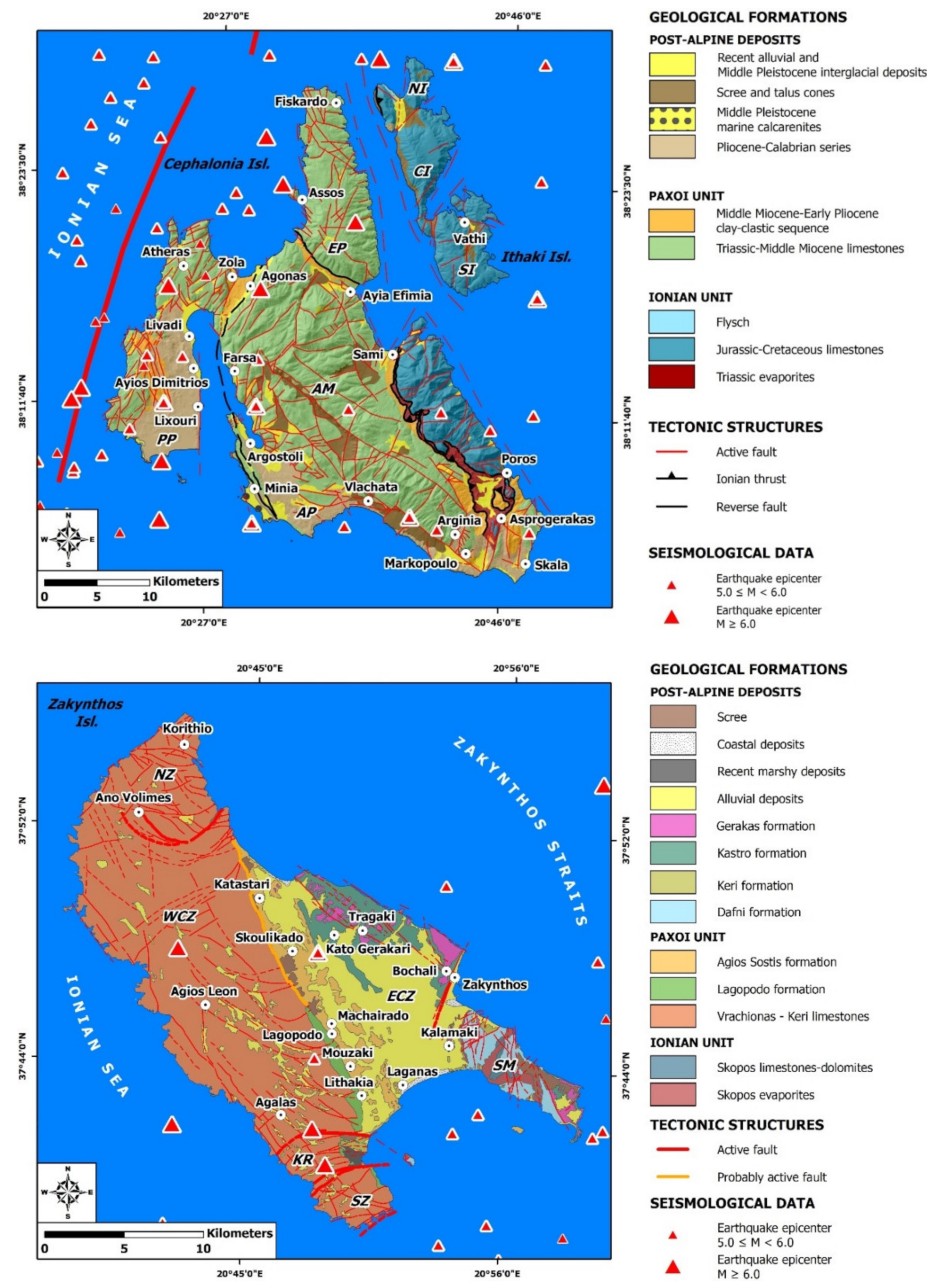
3. Geological Structure of the Southern Ionian Islands

The southern Ionian Islands, comprising Cephalonia, Ithaki and Zakynthos, are mainly composed of alpine formations of Paxoi and Ionian geotectonic units [5,11,12,15,33,34] (Figure 2). The Ionian unit is composed of the flysch sequence of Oligocene–Lower Miocene in Cephalonia and Ithaki, the carbonate sequence from Upper Triassic to Upper Cretaceous in Cephalonia, Ithaki and Zakynthos and the evaporites of Triassic age in Cephalonia and Zakynthos [11,12,15,33,34] (Figure 2). The Paxoi unit comprised the Miocene clay-clastic sequence and the carbonate sequence from Jurassic to Middle Miocene [11,12,15,33,34] (Figure 2). Except for the alpine formations, the geological structure also comprises post-alpine deposits of Pliocene and Quaternary age [11,12,15,33,34] (Figure 2).
From the neotectonic point of view, the southern Ionian Islands are dissected by faults, which led to the formation of fault blocks with different geological formations and kinematic evolution during the neotectonic period [11,12,15,33,34]. Cephalonia is composed of the fault blocks of the Aenos Mt and the eastern Cephalonia as well as the fault blocks of the Paliki, Erissos and Argostoli peninsulas [5,11,12]. Ithaki is divided to three fault blocks, the northern, the central and the southern [5] and Zakynthos is composed of the fault blocks of the northern Zakynthos, the Central Zakynthos, the Keri Bay, the Southern Zakynthos and the Skopos Mt [15,35] (Figure 2).

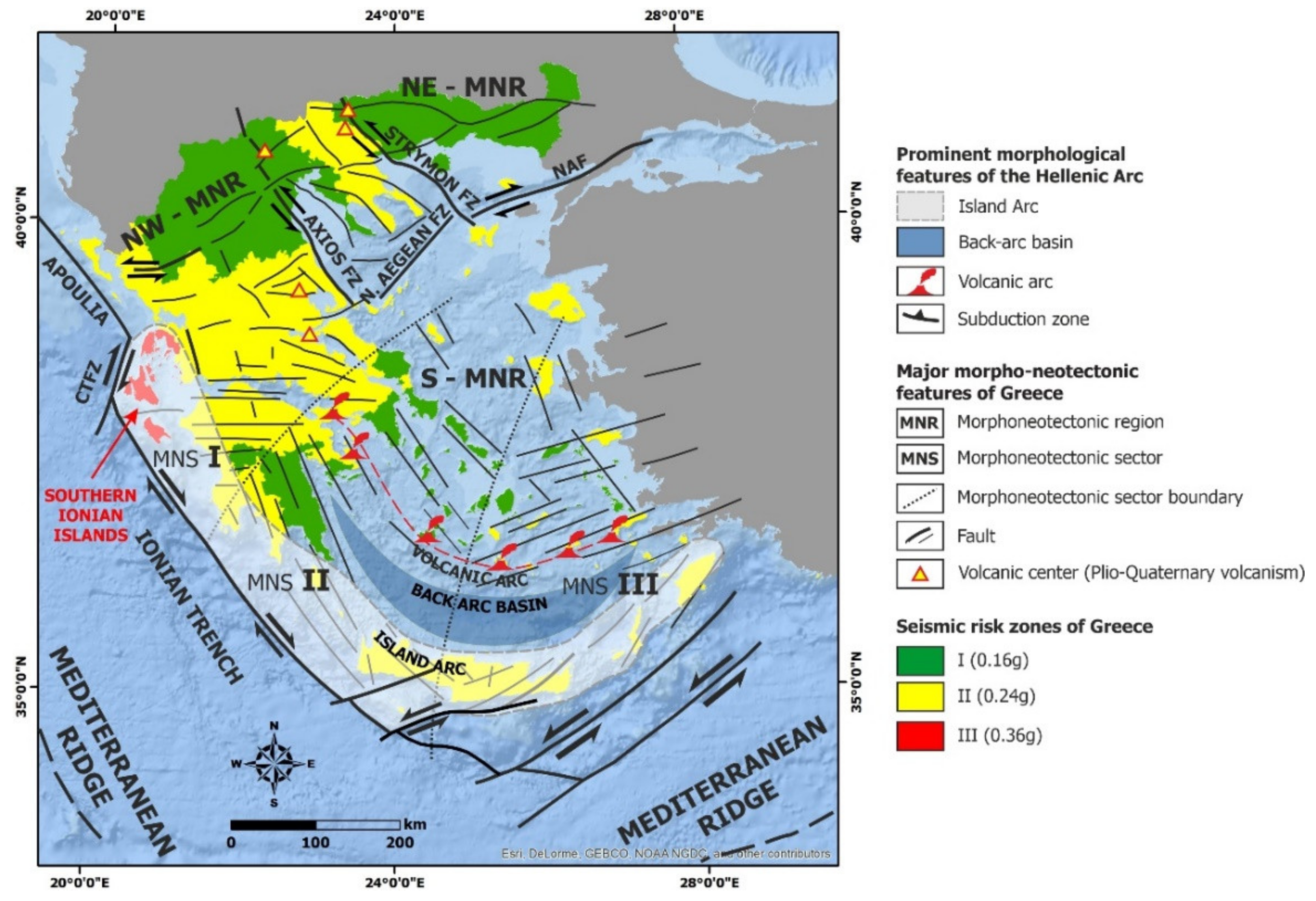
4. Seismicity of the Southern Ionian Islands

From the geotectonic point of view, the southern Ionian Islands are located in the external part of the Hellenic Arc and in the east of the Hellenic Trench, which represents the convergence boundary between the African and Eurasian plates, as it is shown in the introductory figure. Thus, it constitutes one of the most seismically active parts in the Mediterranean region, in Europe and worldwide.
The historical seismicity over the last 500 years is well documented for the southern Ionian Islands. Historical seismicity data indicates that these islands were struck by shallow earthquakes with magnitudes larger than 7.0 and maximum intensities larger than X [15,17,35,37]. According to historical and recent seismicity data, large earthquakes in the southern part of the Ionian Sea are usually generated in couples (twin or cluster events) with the period of their occurrence varying from few days to 5 years [10,38]. Characteristic examples of such events are the earthquakes of 1948 in Lefkada (22 April and 30 June) as well as the earthquakes of 1953 (9, 11 and 12 August), of 1983 (17 and 19 January and 23 March), and of 2014 (26 January and 3 February) in Cephalonia [17].
As regards seismogenic sources in the southern Ionian Islands, earthquakes with magnitudes larger than 5.0 have been concentrated in several seismic zones comprising the western offshore Cephalonia and Lefkada areas, the Zakynthos channel and the respective structural basin between Zakynthos Island and Peloponnese and the area southwest of Zakynthos Island [15]. These seismic zones include significant seismic sources ofhigh productivity and the frequent occurrence of destructive earthquakes in both historical and recent times [39,40].
The prevailing seismogenic source in the study area is the Cephalonia Transform Fault Zone (CTFZ) (Figure 3). The CTFZ comprised two segments: (a) the Lefkada segment to the north, which is located offshore western Lefkada and (b) the Cephalonia segment to the south, which is located offshore western Cephalonia [1,2,3,6,7,41].
The Lefkada segment is a 40-km-long, NE–SW-striking and ESE-dipping fault, extending from the northwestern offshore part of Lefkada Island to the northern offshore part of Cephalonia Island [2,42]. It is characterized by a dextral strike–slip motion along with a small thrust component. The Cephalonia segment is a 90-km-long, NE–SW-striking and ESE-dipping fault, close to the western offshore part of the homonymous island [3,6]. It constitutes the zone with the highest seismicity in the western part of the Hellenic Arc and Trench system [17,33,34,37] including the August 1953 Ionian Sea earthquakes.

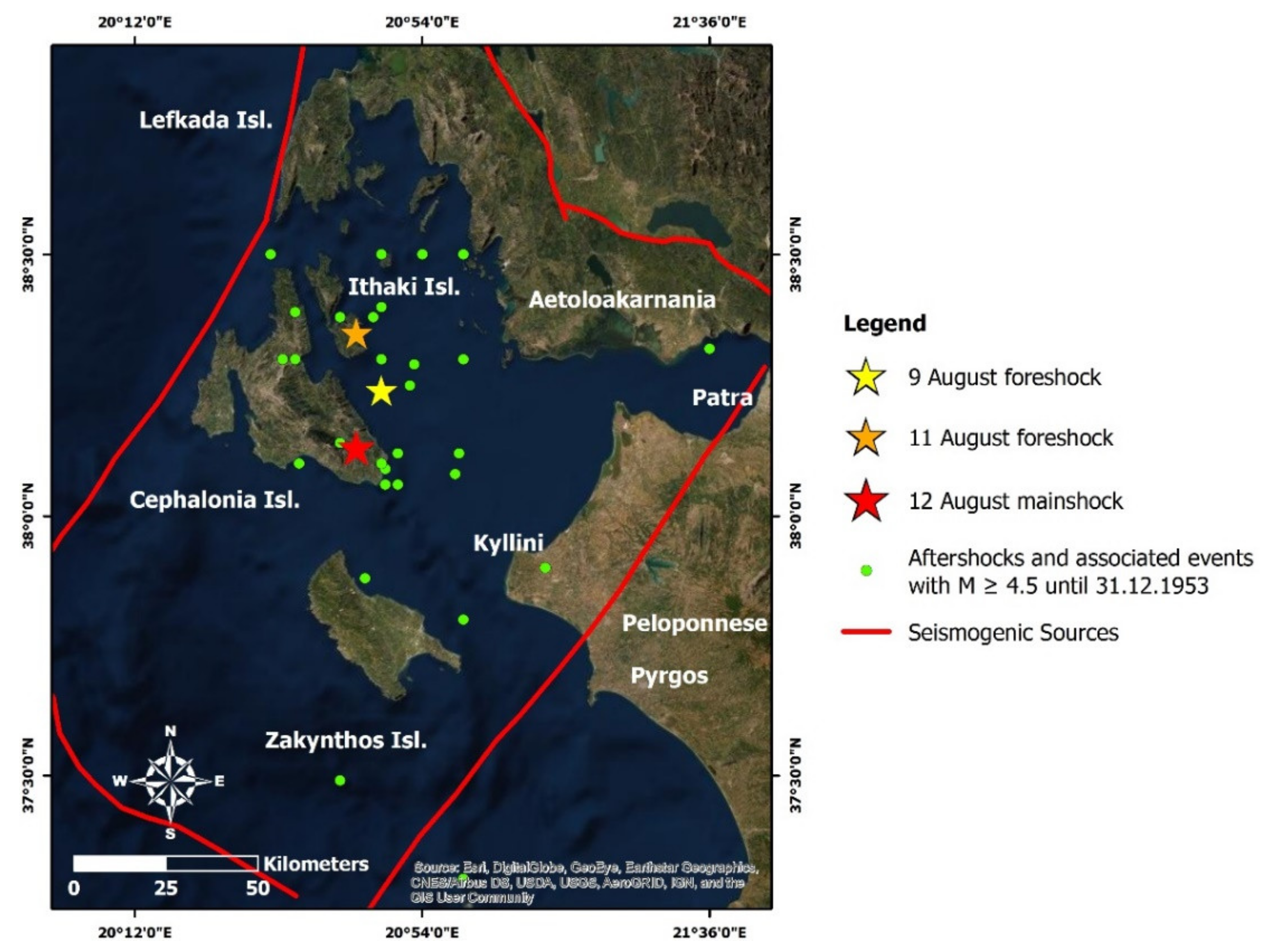
5. The August 1953 Ionian Sea Earthquake Sequence

5.1. Seismological Data

The August 1953 Ionian Sea sequence in the southern Ionian Islands was comprised of a series of devastating earthquakes, the largest of which was generated on 12 August with Ms = 7.3 or Mw = 7.0 based on Makropoulos et al. [25] (Figure 3). The earthquake generated on 9 August (09:41, local time, Ms = 6.1, Mw = 5.9) and on 11 August (05:32, local time, Ms = 6.8, Mw = 6.6) (Figure 3) are considered foreshocks. Before the foreshocks of the early August, an earthquake with Ms = 5.6 (Mw = 5.5) preceded on 22 July.
The aftershock activity was intense, and thousands of aftershocks occurred onshore and offshore southern Ionian Islands. An Ms = 6.3 (Mw = 6.1) event generated few hours after the main shock in the northern part of Zakynthos Island and an Ms = 6.4 (Mw = 6.2) event generated onshore northern Cephalonia on 21 October 1953 were the strongest aftershocks. Based on the updated and extended earthquake catalogue for Greece and adjacent areas since 1900 compiled by Makropoulos et al. [25], the aftershock sequence from 12 August to 28 December 1953 in the southern Ionian Islands contains 66 aftershocks with magnitude equal or larger than 4.5 (Figure 3). Their epicenters were concentrated in the northern, eastern and southeastern onshore part of Cephalonia and offshore eastern Cephalonia and Ithaki (Figure 3). Two offshore events were also generated in this period between Zakynthos and Peloponnese, and two offshore of southern Zakynthos. The aftershock sequence was comprised of 49 events with 4.5 ≤ Mw ≤ 5.0, 13 events with 5.1 ≤ Mw ≤ 5.5, 3 events with 5.6 ≤ Mw ≤ 6.0 and 2 events with 6.1 ≤ Mw ≤ 6.5 (Figure 3). Their focal depth varied from 4 to 43 km. The majority of them were generated at depths varying from 7 to 10 km, based on the aforementioned earthquake catalogue.

5.2. Impact on the Built Environment

In particular, the earthquake of 9 August 1953 struck the southern Ionian Islands and especially Ithaki, Cephalonia and Lefkada. In Cephalonia, Argostoli was severely affected, with the majority of its buildings damaged by the earthquake. Many buildings on the market and along the beach suffered partial or total collapse. Moreover, villages in the Pylaros area of northern Cephalonia became uninhabitable. On the Erissos peninsula, many buildings in several villages suffered extensive damage. Many buildings in the Sami and Pyrgi areas were also damaged. Less damage was observed in other towns and villages in Cephalonia, though none caused human losses or serious injuries. The traffic from Argostoli to the villages headed northwards was disrupted due to destruction of the road network in several sites. A total of about 200 buildings were ruined by the 9 August earthquake in Cephalonia.
The earthquake of August 11 struck Ithaki harder than any other island in the southern Ionian Sea. Vathi town was completely destroyed. Of its 1200 buildings, only 50 were unaffected and still stood after the earthquake. The destructive impact was attributed to strong earthquake-induced ground motion, in terms of intensity and duration. During the earthquakes’ ground motion, and due to building collapse, dense dust clouds covered the entire town and persisted for longer than an hour. In addition to the serious structural damage in Vathi town, it also suffered damage to its infrastructure. The aqueduct was destroyed, resulting in residents’ suffering from a lack of water. The electricity network was destroyed completely, leaving the city in the dark. The telephone and telegraph networks were also destroyed, making communication between the affected areas and adjacent, unaffected areas difficult or impossible. In total, all villages of Ithaki Island were destroyed, except for two, whose buildings nonetheless suffered severe structural damage.
The earthquake of 12 August stuck the Cephalonia, Ithaki and Zakynthos Islands. Zakynthos town, in the homonymous island, as well as Argostoli and Lixouri towns in Cephalonia, were razed to the ground, with subsequent and huge fires completing the devastation in Zakynthos and Argostoli.
In Argostoli, the majority of its buildings were partially or completely destroyed, regardless of their age and construction type. Damages were relatively smaller only in buildings of the town, which were founded upon Pliocene formations [20]. Taking into account macroseismic observations in the wider Argostoli area, and after correlating with the observed geological formations and related lithology, we conclude that buildings which were erected on limestone were less affected than those built on recent deposits of the coastal area, even if they were more recently and better constructed [20].
In Lixouri, almost all buildings were partially or completely collapsed. The only buildings that survived with minor damage, i.e., small cracks, were the primary school and the Vallianos Vocational School, a fact that is attributed to their seismic design and construction [20]. The destruction of the city has been attributed to the severity of the earthquakes’ ground motion, to the age of the buildings, their inadequate construction and the method of joining construction materials with clay, rather than calcareous, material, due to its absence in the wider area [20].
All buildings of the coastal town of Zakynthos were founded on recent alluvial deposits and backfills [20]. Twenty-five percent of the buildings were founded on clay marls [20]. The town was severely affected by the 12 August earthquakes. On that day, two strong earthquakes were felt. The first happened at 11:30 and the second at 14:30 (local time). Residents claimed that the second earthquake was more intense than the first. The subsequent fire burnt the town for 8 days and completed the disaster. The earthquake-induced damage has been attributed to the synergy of many factors, including multistory buildings with inadequate construction and materials founded on the recent alluvial deposits [20]. The antiseismic buildings along the coastal part of Zakynthos town were not severely affected.
In total, 27,659 out of 33,300 buildings in the southern Ionian Islands were completely destroyed, while 2780 were severely damaged, 2394 suffered minor damage and only 467 remained unaffected [16,17] (Table 2). In Lefkada, 122 buildings were seriously damaged and 341 were slightly affected.
The damage extended to the adjacent Aetoloakarnania (western part of the Central Greece), where 18 villages were destroyed and in Elis (western part of Peloponnese), where 46 villages were damaged. More specifically, in Aetoloakarnania, 60 buildings were completely destroyed and 293 were seriously damaged, while, in Elis, 50 buildings were destroyed and 1546 were damaged. The maximum intensities (IX-X) based on the type and the grade of the recorded building damage were observed in Argostoli, Lixouri, Valsamata, Asprogeraka, Havdata and Ayia Efimia of Cephalonia and in Volimes (IX+) and Zakynthos town (IX+) in the homonymous island. The main earthquake was also felt in the southern part of Italy [18,43].

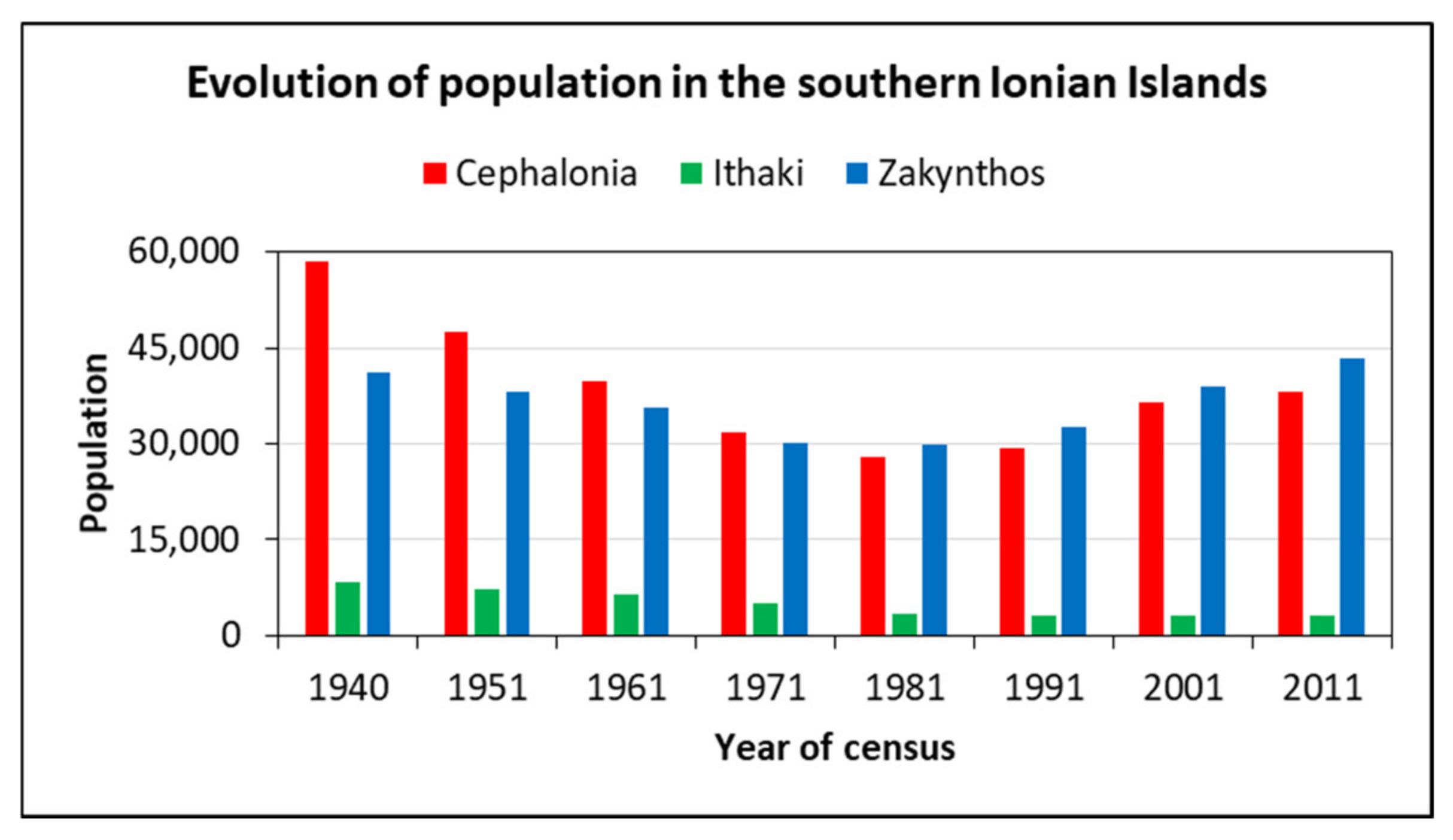
5.3. Impact on the Local Population

The impacts of the earthquakes on the local population were 455 casualties, 2412 injuries and 21 disappearances. These were attributed not only to the partial or total collapse of buildings and debris falling, but also to generation of secondary earthquake environmental effects in the affected islands, and, particularly, to slope failures, such as rockfalls and landslides, along abrupt and high slopes. Despite the fact the 1953 seismic sequence constitutes the most lethal in the recent history of Greece, the number of the fatalities caused is small when we consider the population density in the affected islands at that time. In the majority of the affected residential areas, the generation of the foreshocks on August 9 and 11 kept residents away from their affected houses, resulting in reduced fatalities and injuries from the mainshock.
Beyond the immediate effects on public health, the August 1953 earthquakes affected the demographic features of the southern Ionian Islands. They caused dramatic population outmigration flows, changes in the demographic composition and in the physical, social and economic fabric of the affected areas, as evidenced by the testimonies gathered from the aforementioned local and national sources. Many residents abandoned the islands immediately after the earthquakes. Fearing internal migration (uncontrolled refugee wave) and depopulation of the islands, the government banned unessential movements from the islands a few days after the mainshock.
As regards the long-term earthquake-induced effects on the local population, the inability to financially support the local community resulted in waves of flight and migration both to the major urban centers of Greece and abroad. Based on population census data of the Hellenic Statistical Authority over a period of 30 years, from 1951 to 1981, the population of the three islands decreased from 92,706 in 1951 to 61,012 in 1981 (a decrease of 34.18%) (Figure 4).

5.4. Effects on Building Codes and Disaster Management Policies

It is important to mention that the 9, 11 and 12 August 1953 earthquakes and their effects on the local population, buildings and infrastructure, determined the earthquake policy in post-war Greece. Moreover, they constituted the trigger for introducing the first code for seismic-resistant design for Greece in 1959 (Royal Decree 19-2-1959, Government Gazette 36A/26-2-1959). The first code with some modifications and updates continued to be the main regulatory text, which concerns the quality of the built environment of Greece until the occurrence of large and destructive earthquakes, like those that affected Thessaloniki City (northern Greece), on 20 June 1978 with Mw = 6.2 and the capital of Greece, Athens City, on 24 February with Ms = 6.7, on 25 February with Ms = 6.4 and on 4 March 1981 with Ms = 6.4. Today, earthquake safety constitutes an integral part of the culture in Greece, which now has one of the most advanced codes in the world.
Moreover, the subsequent recovery process from the 1953 earthquakes constitutes a unique recovery milestone for Greek policy, generally. The aim of this recovery process was to transform the disaster experience by fostering resilience, social learning, and the development of a safety culture, in order to further strengthen risk perception. The recovery process had an utmost and long-term catalyzing impact, not only at the local, but also at the national level, defining the entire post-war policy in terms of adopted recovery-reconstruction practices and measures [44].

6. Primary Environmental Effects Induced by the August 1953 Ionian Sea Earthquakes

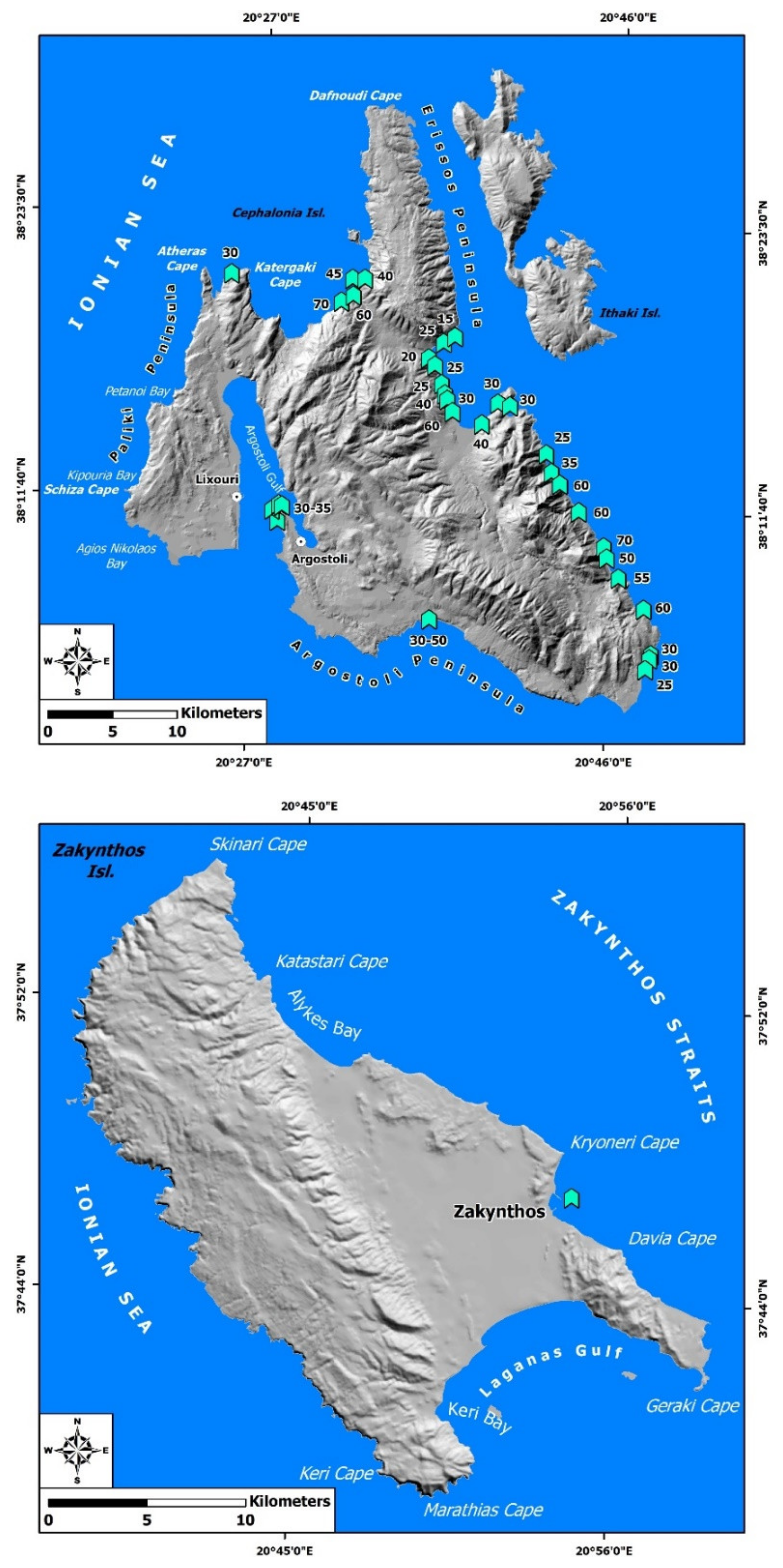
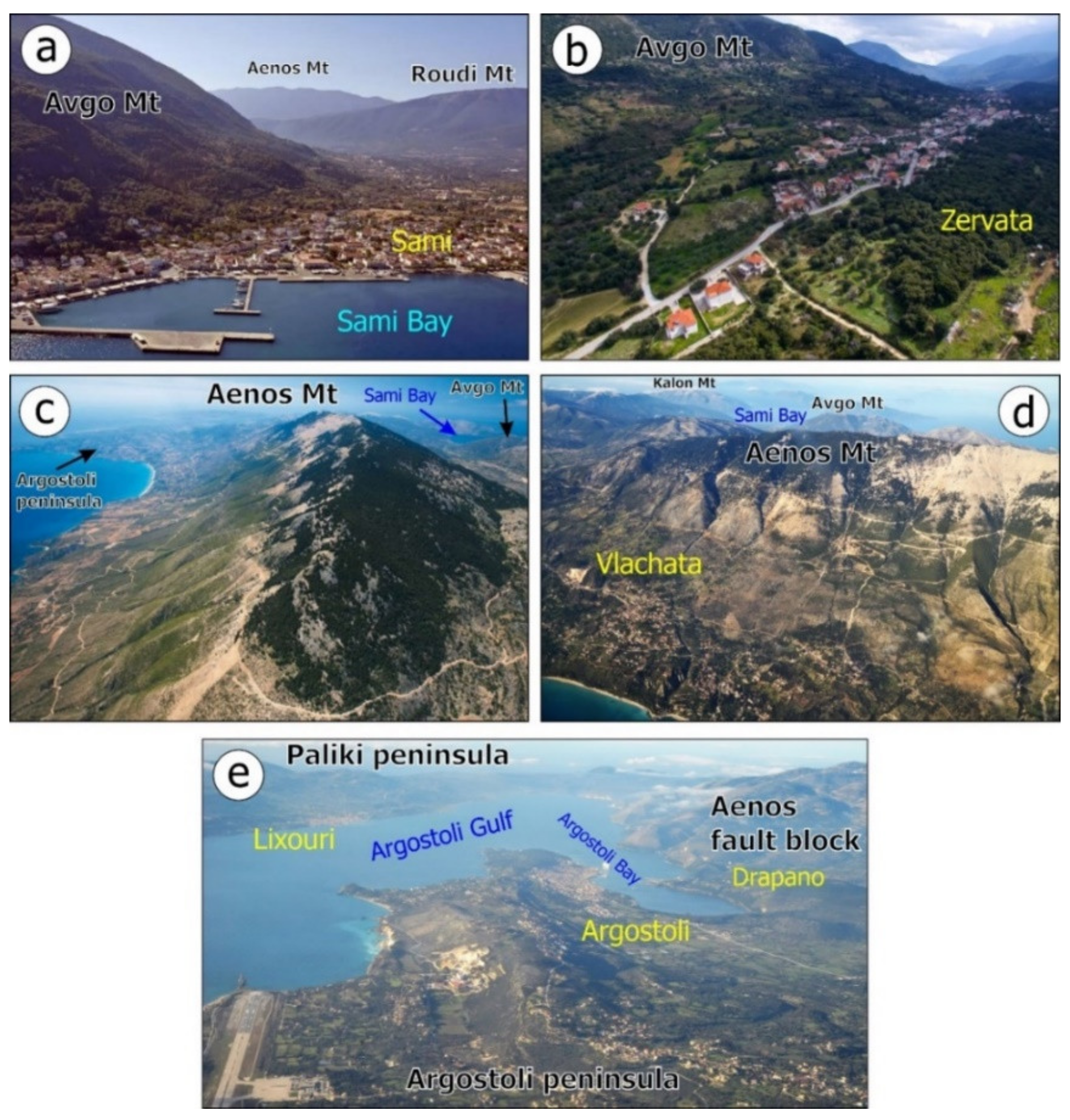
6.1. Permanent Surface Deformation in Cephalonia Island

The main source for inventorying the primary effects of the August 1953 earthquake sequence in the southern Ionian Islands was the multiparametric and interdisciplinary research of Stiros et al. [21] and Pirazolli et al. [22]. Based on geomorphological, marine biological and radiometric data, in combination with earlier post-event field surveys and reports [18,19], they found that the 12 August 1953 earthquake induced primary environmental effects, including permanent surface deformation of tectonic origin and, more specifically, coseismic uplift in the central and northern part of Cephalonia Island. More specifically, it is associated with a 0.3–0.7 m quasi-rigid-body uplift and the westward tilting of the central part of the island [21].
Stiros et al. studied systematically the coasts of Cephalonia and Ithaki Islands [21]. Taking into account geomorphological and marine biological observations, along with field data and radiocarbon dating results, they identified uplifted fossil shorelines in several sites of Cephalonia. Moreover, they determined the amount of the coseismic uplift attributed to the 1953 earthquake sequence in several coastal sites along:
  • the eastern coastal part of the Aenos Mt fault block
  • the southern and western coasts of Argostoli peninsula
  • the western coastal part of the transition zone between the Aenos Mt and the Erissos peninsula.
More specifically, coseismic uplift was detected in the following areas (Figure 5):
  • in three sites along the coast located northeast of Ayia Efimia, ranging from 15 to 25 cm
  • in several sites along the coast of Sami Bay, extending from Ayia Efimia located northwards to Sami located southwards (uplift ranged from 25 to 60 cm)
  • in several sites along the coast of Sami Bay, extending northeastwards of Sami (uplift ranged from 30 to 40 cm)
  • along the coast extending from the area located southeastwards of Sami to the area located southeast of Poros (uplift ranged from 50 to 70 cm)
  • along the southern coast of the fault block of Argostoli peninsula and, more specifically, along the coast located south of Moussata village (uplift ranged from 30 to 50 c)
  • along the western part of Argostoli peninsula (uplift ranged from 30 to 35 cm)
  • along the western coastal part of the transition zone between the Aenos Mt and the Erissos peninsula; in particular, uplift in Myrtos coastal area ranged from 30 to 70 cm
  • Permanent surface deformation was not detected in the western and northern part of the island, and, more specifically, on the Paliki and Erissos peninsulas, respectively.
Moreover, Pirazolli et al. conducted an interdisciplinary study along the coasts of the Ionian Islands with scientists from various scientific fields, including geology, geomorphology, marine biology and archaeology [22]. They detected uplifted shorelines strongly related to seismotectonic processes and seismic events during the Holocene. As regards Cephalonia, they detected two vertical movements that have affected the island. The first was generated between 350 and 710 AD and the second in 1953; both resulted in the uplift of the southeastern part of Cephalonia.
Pirazolli et al. detected coseismic uplift attributed to the 1953 earthquake sequence in Poros port (+0.55 m), in a bay located south of Poros port (+0.50 m), in Skala coastal area (+0.30 m), in Karavomylos (+0.50 m), in the coastal area west of Myrtos (+0.70 m) and in Katavothres (+0.15 m) [22] (Figure 5).
Prior to the systematic research of Stiros et al. and Pirazolli et al. in the Cephalonia and Ithaki Islands [21,22], Galanopoulos and Mueller-Miny studied coseismic surface deformations not only in Cephalonia and Ithaki Islands, but also in the other earthquake-affected islands of the Ionian Sea [18,19]. Based on their results (Figure 5):
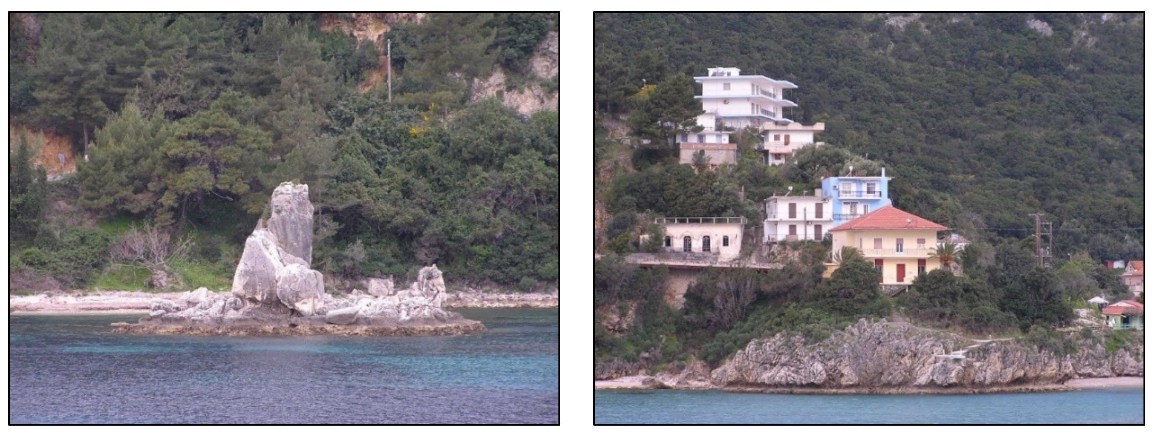
  • In the Poros coastal area, located in southeastern Cephalonia, at a distance of about 50 m from the shoreline, an already emerged rock was uplifted by the earthquake and looked like a mushroom due to the emerged notches and benches (Figure 6). The coseismic uplift ranged from 60 to 70 cm, based on Galanopoulos [18].
  • In Argostoli sinkholes (Katavothres in Greek), the coseismic uplift resulted in the interruption of the seawater flow to its watermills. The coseismic uplift was about 30 cm based on Mueller-Miny [19].
  • A coseismic uplift of 50 cm was detected in several sites along the southern coast of Cephalonia Island and, more specifically, southeast of Argostoli town.
Taking into account the distribution of the primary earthquake environmental effects, the systematic study of Stiros et al. of the uplifted shorelines in Cephalonia Island [21] and the marginal fault zones of the affected fault blocks mapped by Lekkas et al. [5,34], it has been shown that the distribution of the surface deformation induced by the August 1953 Ionian Sea earthquake sequence is strongly related to the active tectonic structures of the affected area. More specifically, the uplift was limited to the eastern part of Cephalonia, in an area bounded by the active Livadi fault zone, located between Aenos Mt in the east and Paliki peninsula in the west, and the Ayia Efimia fault zone crossing the homonymous area and defining the eastern and offshore part of Cephalonia [15].

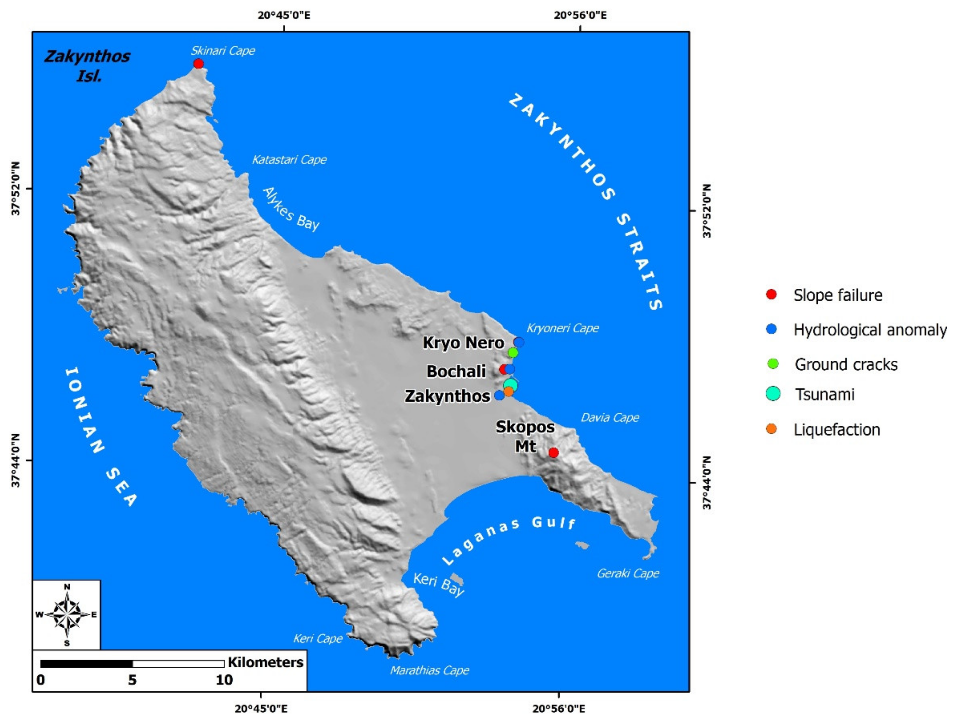
6.2. Primary Effects in the Ithaki and Zakynthos Islands

As regards primary environmental effects induced by the August 1953 earthquakes in the other affected southern Ionian Islands, permanent coseismic uplift or any other evidence of permanent coseismic surface deformation were not detected in Ithaki. In Zakynthos Island, permanent coseismic uplift has been detected close to the homonymous town, towards Cephalonia, resulting in emergence of a small island (TAXYDROMOS, 16.08.1953).

7. Secondary Environmental Effects Induced by the 1953 Ionian Sea Earthquakes

The 1953 Ionian Sea earthquake sequence induced not only primary but also secondary environmental effects in Cephalonia, and also the adjacent Ithaki and Zakynthos Islands. The secondary effects included slope failures (mainly rockfalls and slides), ground cracks, liquefaction phenomena, hydrological anomalies, tsunami, jumping stones and impact on vegetation.

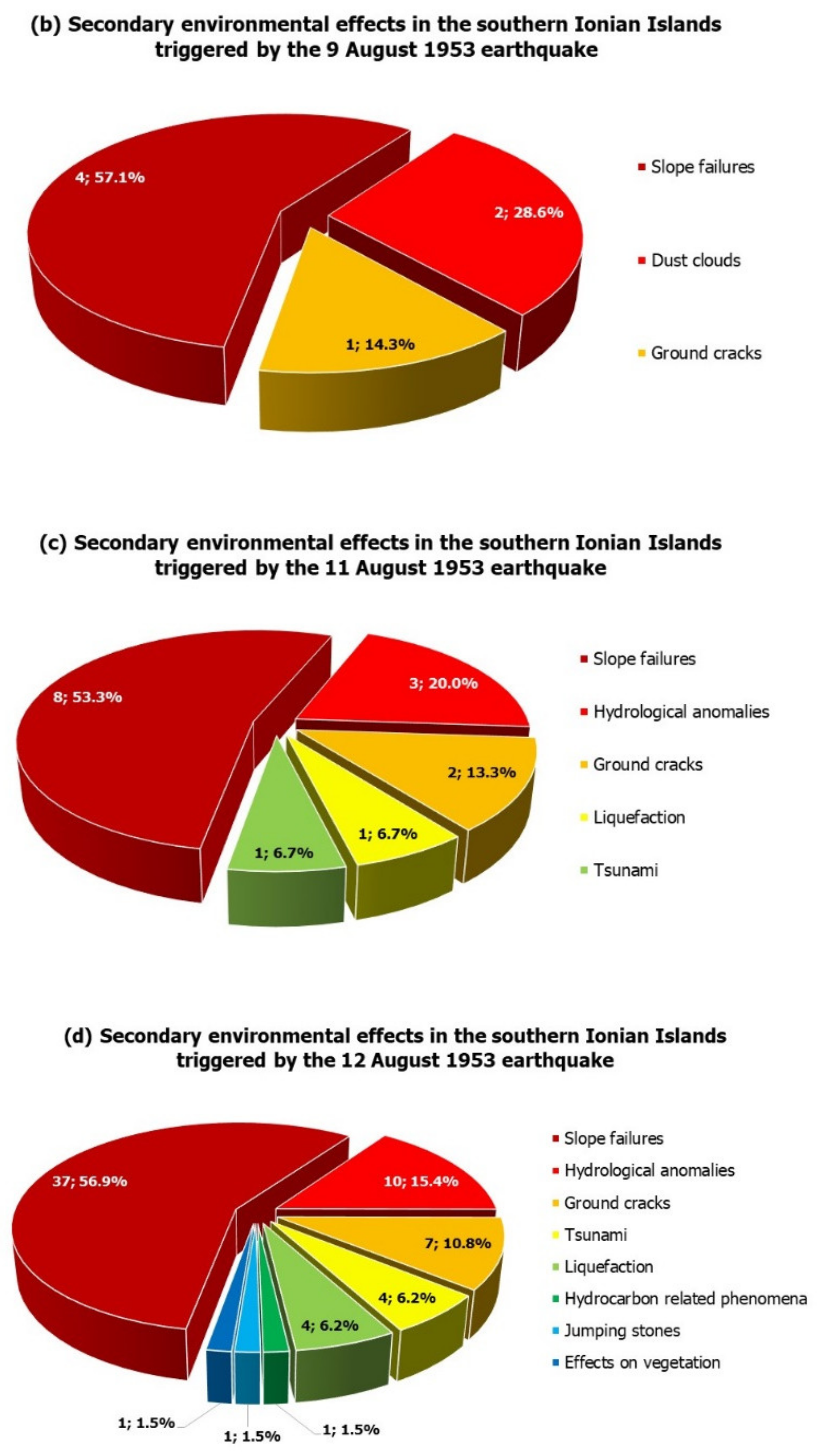
7.1. Secondary Effects Induced by the 9 August 1953 Earthquake in Cephalonia and Ithaki

The 9 August 1953 earthquake triggered slope failures, ground cracks and dust clouds. In Cephalonia, slope failures and, in particular, rockfalls occurred in the quarries of Argostoli town (ETHNIKOS KIRIX, 10.08.1953), which were located close to the beach (Figure 7). Similar effects have occurred along the road network between Argostoli and the northern part of the island and, in particular, along the western slopes of Ayia Dynati Mt (NEOLOGOS PATRON, 11.08.1953; PELOPONNISOS, 11.08.1953; EMPROS, 11.08.1953; Figure 7). Dust clouds were induced by the 9 August earthquake and they were attributed not only to collapse of buildings and slope failures, but also to the intense ground motion (I IMERA, 11.08.1953; NEOLOGOS PATRON, 11.08.1953; EMPROS, 11.08.1953; Figure 7). These clouds covered the Erissos and Pylaros provinces in northern Cephalonia (I IMERA, 11.08.1953).
In Ithaki Island, the 9 August 1953 earthquake triggered slope failures (ELEFTHERIA, 11.08.1953) as well as ground cracks and related subsidence (TA NEA, 10.08.1953; ETHNIKOS KIRIX, 10.08.1953; I IMERA, 11.08.1953; NEOLOGOS PATRON, 11.08.1953; Figure 7).
More specifically, large and extensive ground cracks and related subsidence were generated along the main road leading from the Vathi area, located in the southern fault block, to the Stavros area, located in the northern fault block of the island (ETHNIKOS KIRIX, 10.08.1953; I IMERA, 11.08.1953; NEOLOGOS PATRON, 11.08.1953; Figure 7). These effects resulted in damage in several sites along the main road network, itself resulting in temporary traffic disruption between the northern and the southern part of the island (ETHNIKOS KIRIX, 10.08.1953; NEOLOGOS PATRON, 11.08.1953). Moreover, slope failures, including rockfalls and slides, in several sites along the road network of Ithaki Island resulted in similar damage. No additional data for the exact location of the earthquakes’ effects in Ithaki Island are available. Moreover, no related quantitative information for the detected ground cracks and slope failures were obtained from the aforementioned sources.

7.2. Secondary Effects Induced by the 11 August 1953 Ionian Sea Earthquake in Cephalonia, Ithaki and Zakynthos

The 11 August 1953 earthquake triggered slope failures, comprised of mainly rockfalls and slides, anomalous waves/tsunami, hydrological anomalies, ground cracks attributed to liquefaction phenomena and hydrocarbon-related effects.
Slope failures were induced by the 11 August 1953 earthquake in Cephalonia Island (TO VIMA, 12.08.1953; I IMERA, 12.08.1953; NEOLOGOS PATRON, 12.08.1953; PELOPONNISOS, 12.08.1953; Figure 8). More specifically, rockfalls were generated along the road network leading to Chionata, Skala and Poros villages in the southeastern Cephalonia (TO VIMA, 12.08.1953), in the Sami area (NEOLOGOS PATRON, 12.08.1953), along the road network leading from Sami to Argostoli town (TO VIMA, 12.08.1953), along the slopes over Tzanata village (PELOPONNISOS, 12.08.1953) and along the road leading from the Argostoli to Eleios–Pronnoi area (I IMERA, 12.08.1953; Figure 8). The detachment of scree from bedrock and subsequent slides and rockfalls were also triggered in Lourdata village (TO VIMA, 12.08.1953; I IMERA, 12.08.1953; Figure 8), based on Galanopoulos reports published in newspapers.
The aforementioned slope failures resulted in the destruction of the road network and temporary traffic and communication disruption, which are vital in the first hours and days of a response to an earthquake emergency. Slope failures also affected residential areas in Cephalonia and resulted in very heavy structural damage to buildings, fatalities and injuries. In the case of Tzanata village, rockfalls caused the complete destruction of buildings, the uprooting of trees and 14 fatalities (PELOPONNISOS, 12.08.1953).
A tsunami was triggered by the 11 August 1953 earthquake and affected several coastal areas in Cephalonia, Ithaki and Zakynthos Islands. The most characteristic case was reported in the coastal area of Vathi in Ithaki (ELEFTHERIA, 12.08.1953; EMPROS, 12.08.1953; TO VIMA, 12.08.1953; NEOLOGOS PATRON, 12.08.1953; PELOPONNISOS, 12.08.1953; Figure 8). The waves were one-meter high and inundated a 1-km-long coastal area, to a maximum distance of 200 m from the shore (ELEFTHERIA, 12.08.1953; EMPROS, 12.08.1953). The Customs Office of Vathi was flooded by the inundation (NEOLOGOS PATRON, 12.08.1953). The sea withdrew and then returned to inundate the same area. Similar phenomena were also observed during the aftershock sequence and mainly after its largest seismic events (ELEFTHERIA, 12.08.1953; EMPROS, 12.08.1953).
Hydrological anomalies were also reported (NEOLOGOS PATRON, 12.08.1953). They were generated in the earthquake-affected Cephalonia. These effects included turbidity in wells and changes in the water discharge of springs. Old springs ran dry and new ones appeared close to the old. In Chaliotata, a spring, at a distance of about 100 m west of the village, was affected by the earthquake on 11 August [20] (Figure 8). Its water discharge increased after the earthquake. The same spring was also affected by the mainshock on 12 August.
The residents of Vathi in Ithaki, who were affected by the earthquake of 11 August 1953 earthquake, suffered from lack of potable water due to destruction of their aqueduct and to wells of questionable purity (ELEFTHERIA, 1953). In order to prevent infectious disease outbreaks, the public health authorities of the time had ordered a general anti-typhoid vaccination, while aqueducts and other wells were regularly disinfected with calcium hypochlorite for water treatment (ELEFTHERIA, 1953).
Ground cracks were formed in several sites of the earthquake-affected islands. The most characteristic case was in Metela square (Figure 8), next to Argostoli prison, which was affected by the intense ground shaking and partially collapsed due to ground cracks and related subsidence (PELOPONNISOS, 12.08.1953). Ground cracks were also formed in the Vathi coastal area in Ithaki (TO VIMA, 12.08.1953). The coast of Zakynthos town and its jetty also suffered ground cracks (PELOPONNISOS, 12.08.1953; TA NEA, 11.08.1953; I IMERA, 12.08.1953; EMPROS, 12.08.1953; Figure 8). These could be attributed to liquefaction-induced lateral spreading (TA NEA, 11.08.1953; I IMERA, 12.08.1953).
Sulphureous gas emissions and subsequent flames emerging from ground cracks, indicating combustion of natural gas, was also reported (NEOLOGOS PATRON, 12.08.1953), though no information on the exact location was available.

7.3. Secondary Effects Induced by the 12 August 1953 Ionian Sea Earthquake in Cephalonia Island

Based on the available data and information of the impact on the natural environment, the 12 August 1953 earthquake induced slope movements, liquefaction phenomena, hydrological anomalies, ground cracks, anomalous sea waves/tsunami, dust clouds, effects on vegetation and hydrocarbon-related phenomena. Taking into account the spatial distribution of the detected effects, it is concluded that the 12 August 1953 earthquake affected Cephalonia, Ithaki and Zakynthos.

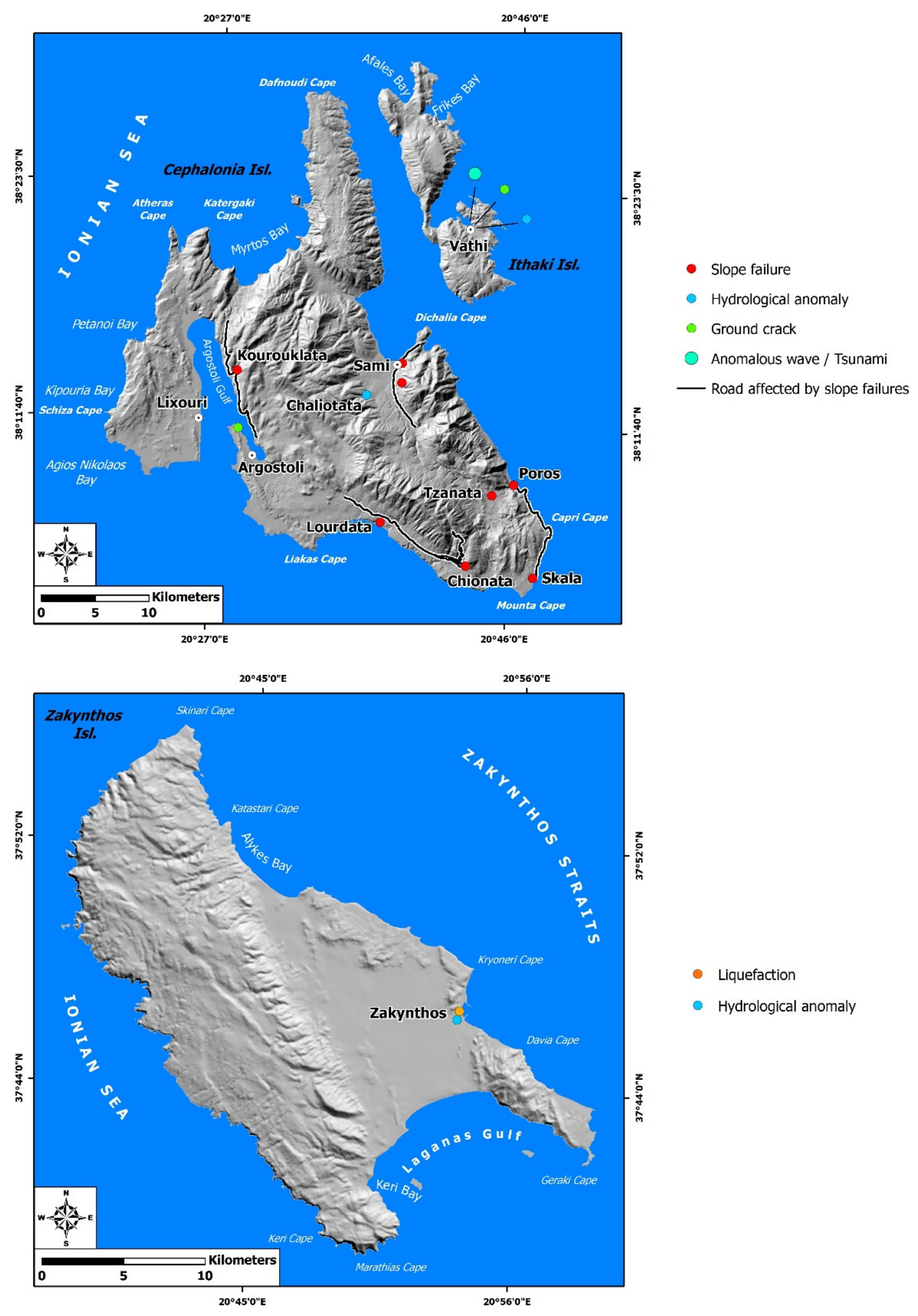
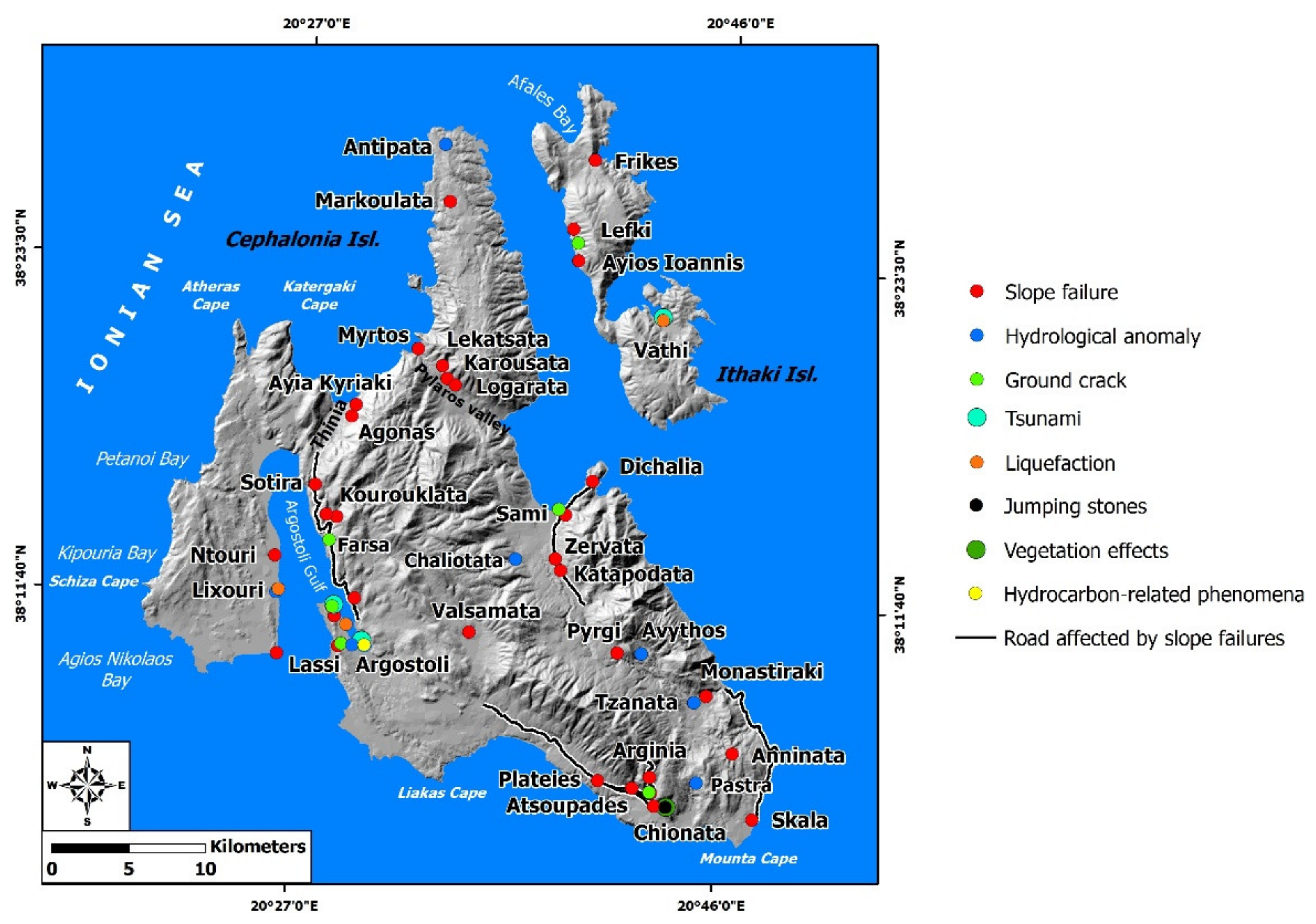
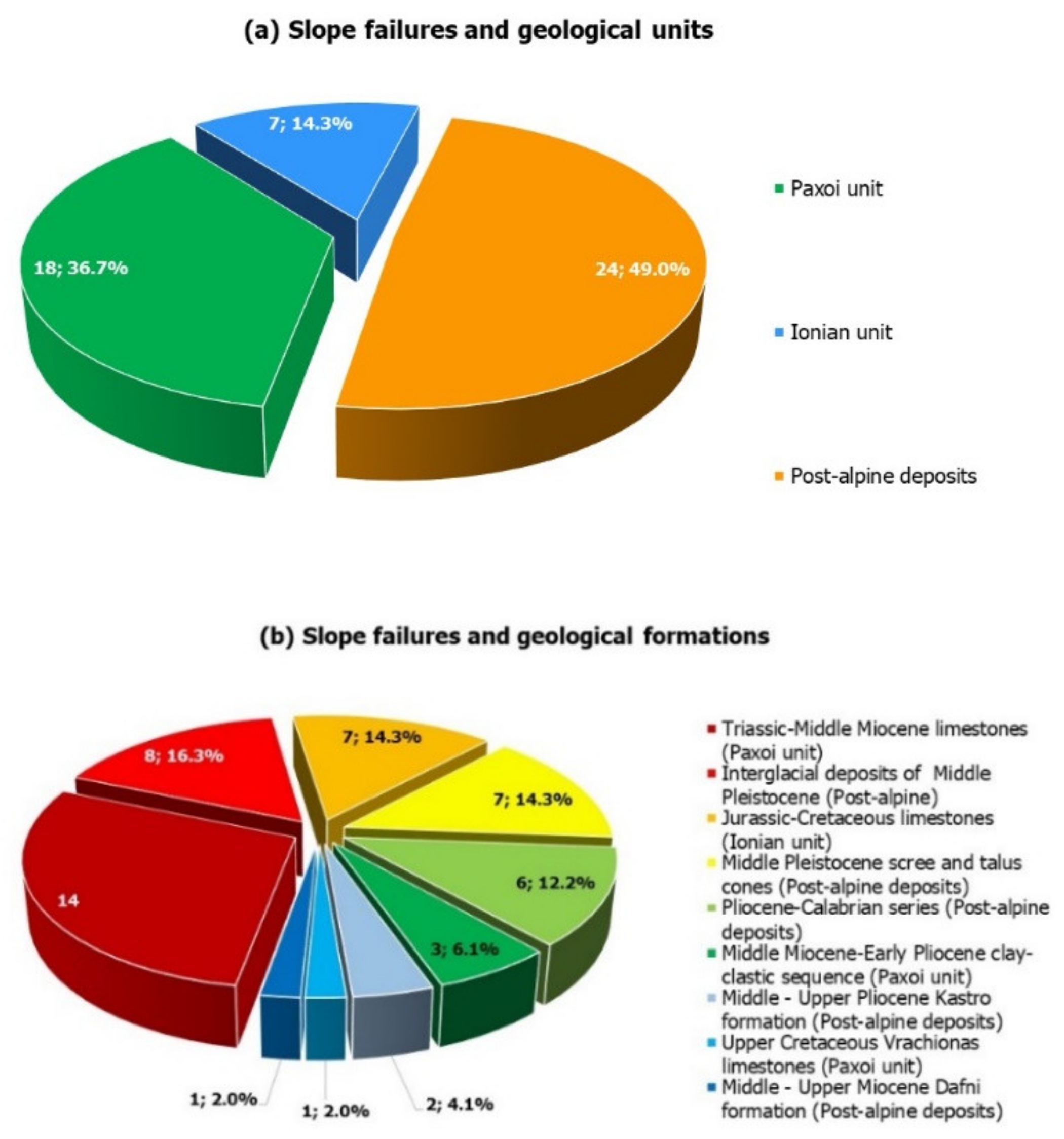
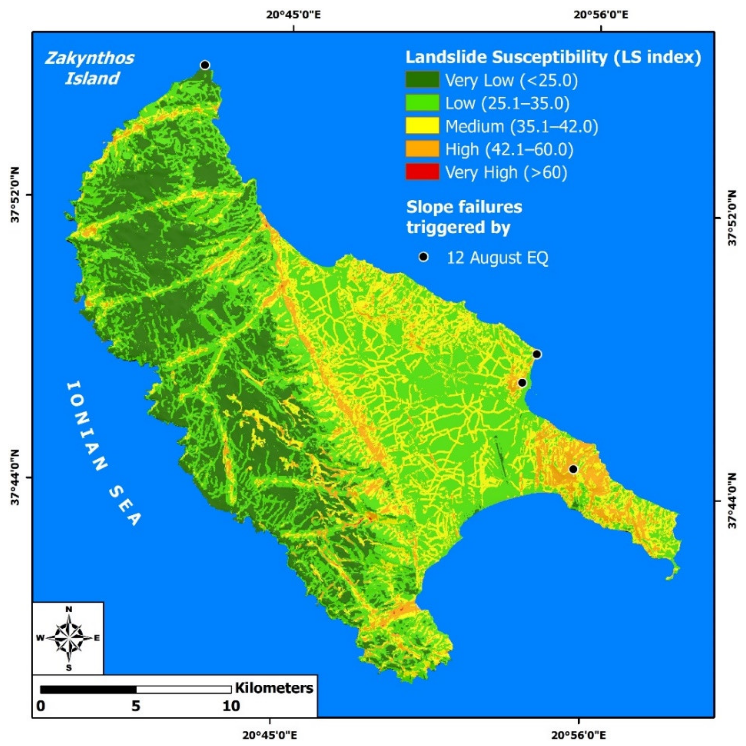
7.3.1. Slope Failures

The earthquake on 12 August 1953 triggered slope failures in several sites. Related information was extracted not only from the official report of the IGUR [20], but also from several newspapers of local and national circulation including TA NEA, TAXYDROMOS, ELEFTHERIA, EMPROS, I IMERA, NEOLOGOS PATRON and PELOPONNISOS. The triggered slope failures can be classified into the detachment of boulders from abrupt slopes and subsequent rockfalls and landslides. In the majority of the affected sites, the triggered slope failures were rockfalls; boulders detached from steep slopes and rolled downward, crushing buildings and causing structural and non-structural damage to roads, resulting in traffic and communication disruption between affected villages, and to vegetation, including mainly olive groves and vineyards.
In several villages, they aggravated damage induced by the earthquake ground motion resulted in greater fatalities and injuries. In particular, villages founded on alpine formations in the mountainous areas of Cephalonia were mostly destroyed by these slope failures.
These sites are distributed along slopes in (Figure 9, Figure 10 and Figure 11):
  • the northern part of Erissos peninsula (Markoulata village)
  • the southern part of Erissos peninsula (Karousata, Lekatsata, Logarata villages)
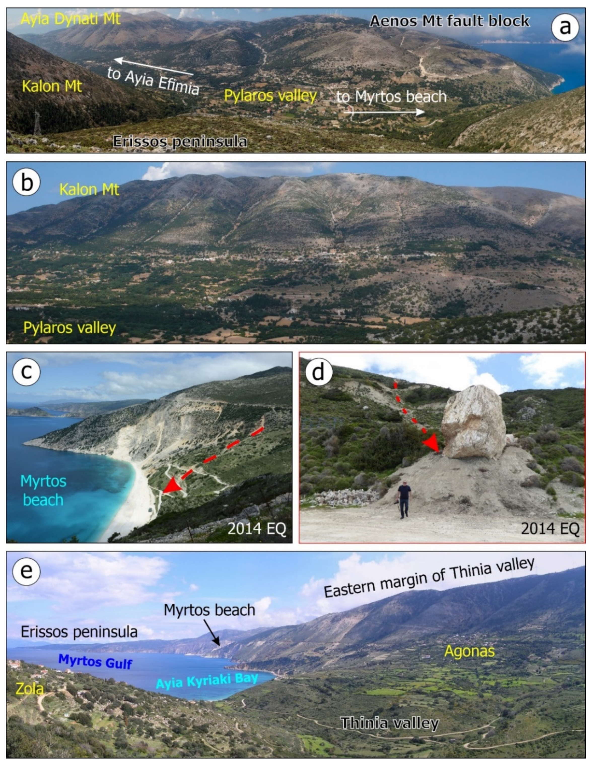
  • Myrtos beach
  • the eastern margin of Thinia valley (Agonas village and Ayia Kyriaki area)
  • the western part of Aenos fault block comprising slopes of Ayia Dynati Mt (Kourouklata village, Drapano area)
  • the western part of the Avgo Mt in eastern part of Cephalonia (Sami, Zervata and Katapodata villages)
  • the eastern part of Roudi Mt (Pyrgi village)
  • the southern part of the Atros Mt (Tzanata and Monastiraki villages)
  • the southern front of Aenos Mt (Atsoupades, Kolaitis, Arginia, Chionata and Plateies villages)
  • the southeastern end of Cephalonia (Skala area, Anninata village)
  • the northeastern end of Argostoli peninsula (Argostoli area)
  • the eastern part of Paliki peninsula (Ntouri area and the southeastern end Paliki).
Moreover, failures were observed along slopes in the road network leading from Sami to Argostoli and from Argostoli to Livadi.
In Markoulata village, located in the northern part of the fault block of Erissos peninsula, rockfalls took place along an adjacent hill [20] (Figure 11).
Along the southern slopes of Kalon Mt (Figure 9a,b and Figure 11), which is located in the southern part of the fault block of Erissos peninsula and composed of highly fragmented limestone rockmass, extended rockfalls were triggered [20]. Rockfalls were generated along a gorge between Karousata and Lekatsata, resulting in damage to olive trees. Rockfalls were also induced at a large scale in the areas of Logarata and Karousata. Part of the damage observed in the building stock of these villages is attributed to rockfalls. These effects are attributed to the occurrence of the Ayia Efimia fault, juxtaposing the Erissos fault block in the north against the Aenos Mt fault block in the south [11,12,37] (Figure 9a).
The Myrtos coastal area is particularly susceptible to the generation of slope failures induced by earthquakes. Its main morphological feature is the very steep slopes of the coastal zone dipping to the NW, which reach or even exceed 50° (Figure 9c,d and Figure 11). This rough morphology is attributed to intense uplift of tectonic origin that has been suffered throughout the whole western part of the Erissos peninsula [37].
Abrupt slopes, along with reduced geotechnical characteristics, clay–marl composition of clastic flysch formations and an overlying scree mantle constitute ideal conditions for significant failures in case of strong earthquakes in Myrtos area. These failures mainly consist of rockfalls, slides and flows. The dip of beds is nearly the same as the dip of slopes, which is a factor that favors the generation of slope failures, especially during strong ground motion, such as that caused by the 12 August 1953 earthquakes. The synergy of this similarity, the presence of groundwater, the occurrence of small springs along the slopes and human intervention, including road construction, intensified the instability of formations on the slopes.
During the 12 August 1953, a limestone boulder detached from a slope in the Myrtos coastal area and ended up in the adjacent bay (EMPROS, 14.08.1953). The sea had changed color from the many unstable materials that had fallen into it. The failures induced along the Myrtos coastal slopes resulted in the total destruction of a small church (EMPROS, 14.08.1953). Similar rockfalls were also observed, in the same site, in the early 2014 Cephalonia earthquakes (26 January and 3 February), resulting in temporary traffic disruption and crush damage to the road leading to Myrtos beach [11,12] (Figure 9c,d). Moreover, the same area has been also affected not only by geological hazards, but also by hydrometeorological hazards, such as the Ianos medicane in September 2020 [45]. Ianos suffered extensive landslides, rock falls and debris flows on its steep slopes, upstream of Myrtos beach, that completely destroyed the road leading to the beach [45].
Slope failures were also generated along the eastern margin of Thinia valley (Figure 9e and Figure 11). This valley has been formed in the transition zone between the northwestern part of Ayia Dynati Mt located eastwards and the northeastern part of Paliki peninsula located westwards. Its length is 6 km, its width is up to 2 km, and its elevation in the central part is around 180 m. It is bounded on either side by steep hill ranges rising to almost 1 km on its eastern margin. These ranges are fault-controlled, resulting in a rugged morphology with steep slopes, a dense net of discontinuities and sectors of decreased cohesion and formation-loosening that make the aforementioned margins susceptible to earthquake-induced slope failures [11,12].
The 12 August 1953 earthquake triggered rockfalls in slopes above Agonas village (Figure 9e and Figure 11), over the almost E–W-trending Ayia Kyriaki coast and from the mountain over Sotiras beach (Figure 11). All sites are located along the eastern margin of the Thinia valley. The rockfalls affected the upper part of Agonas, while its lower part was protected by a series of olive trees, which acted as a barrier against down-rolling boulders [20]. The debris rockfalls in the Ayia Kyriaki area reached the sea, causing local disturbance and temporary change to its color (TAXYDROMOS, 16.08.1953). It is of significance that the eastern margin of Thinia valley was affected by slope failures induced by the early 2014 Cephalonia earthquake sequence and consisted of rockfalls, rock toppling failures and landslides [11].
Slope failures were also generated on the western slopes of Ayia Dynati Mt (Figure 11). This area is composed of Cretaceous limestones, karstified at a large scale, resulting in loose and highly weathered limestone blocks in surface and many hidden karst cavities, at depth. It is also characterized by intense relief, with steep slopes, large morphological discontinuities and gorges born of the synergy between uplift and incision [11]. The 12 August 1953 earthquake triggered rockfalls along the abrupt slopes of Tiganeto and Chalio Mts surrounding Kourouklata [20], which was the worst affected village (PELOPONNISOS, 16.08.1953). It was completely destroyed by falling boulders.
Based on witnesses of prisoners in Argostoli prison, extensive slope failures occurred in the area north of Drapano [46]. Based on the geological and geomorphological structure of this area and the environmental effects induced in the same area by recent strong earthquakes in Cephalonia [11], it could be concluded that extensive rockfalls of unstable limestone blocks were generated along the western slopes of Ayia Dynati Mt, without impact on residential areas. These blocks ended up in the adjacent sea of the Argostoli Gulf according to the aforementioned description [46].
Rockfalls were also triggered along the western slopes of Avgo Mt (Figure 10a,b and Figure 11), in eastern Cephalonia [20]. They affected villages founded along the mountain front comprising Sami (Figure 10a and Figure 11), Zervata (Figure 10b and Figure 11) and Katapodata (Figure 11; TA NEA, 12.08.1953; Taxydromos, 14.08.1953, 19.08.1953; I IMERA, 13.08.1953).
At a distance of about 50 m from Dichalia village, located almost 5 km northeast of Sami (Figure 11), failure of a coastal part with an area of 1000 m2 took place before the August earthquakes. After the generation of the studied earthquakes, the failures were reactivated and the area was further subsided by 1 m [20].
In Sami area, extensive rockfalls were triggered along the western slopes of Avgo Mt (Figure 11). They formed a dust cloud, which was visible from the neighboring island of Ithaki, and looked like a dense cloud of fire (I IMERA, 13.08.1953). These phenomena affected the town and the road network leading from Sami to the surrounding villages (TA NEA, 12.08.1953; TAXYDROMOS, 14.08.1953, 19.08.1953; I IMERA, 13.08.1953). Several mountainous villages were cut off for days by boulders that had accumulated on the road (TAXYDROMOS, 14.08.1953).
In the Zervata area, where Alevrata, Zervata and Mouzakata villages were merged into Zervata village (Figure 11), rockfalls caused structural and non-structural damage to buildings, damage to the road network and effects on vegetation, including the destruction of olive trees and vineyards (TAXYDROMOS, 14.08.1953). Many buildings collapsed, while the traffic and communication with the surrounding villages and the rest of Cephalonia were disrupted for days. The village looked like an excavation, attributed to earthquake ground motion and its subsequent rockfalls.
In Katapodata village, rockfalls resulted in further damage to some buildings [20].
Pyrgi village, founded on the eastern slopes of Roudi Mt located between Ayia Dynati Mt in the north and Aenos Mt in the south, was also affected by rockfalls (Figure 11; TAXYDROMOS, 19.08.1953). The boulders were accumulated on the adjacent roads resulting in temporary traffic disruption.
West of Roudi Mt, Valsamata village suffered from slope failures (Figure 11). Rockfalls were generated along the slopes over the village and contributed to its complete destruction, which was already heavily affected by the earthquake ground motion (TAXYDROMOS, 14.08.1953).
Monastiraki and Tzanata villages, founded in the southern slopes of Atros Mt in the eastern part of Cephalonia, were also affected by slope failures (Figure 11). Rockfalls were triggered along an abrupt slope northeast of Monastiraki [20]. In Tzanata, rockfalls were triggered along the slopes over the village. Boulders detached from the bedrock, rolled down towards the village and caused heavy structural damage to buildings (TAXYDROMOS, 14.08.1953; I IMERA, 14.08.1953). As a result, they increased the number of fatalities and injuries in the area.
The southern and southeastern front of Aenos Mt (Figure 10c,d and Figure 11) was severely affected by slope failures induced by the 12 August 1953 earthquake [20]. Extensive rockfalls were generated. Atsoupades, Kolaitis, Arginia, Chionata and Plateies villages (Figure 11) suffered damage, while the roads in the area were blocked (I IMERA, 13.08.53).
In Atsoupades village, boulders detached from the abrupt slopes of Aenos Mt and subsequent rockfalls took place north of the village. Many boulders fell on its houses, resulting in considerable non-structural and structural damage, as well as panic and anxiety in residents [20]. Large boulders fell in the road network of the area, resulting in the temporary disruption in traffic and communication with other villages.
Kolaitis village was completely destroyed by rockfalls [20]. In Arginia village, rockfalls were also generated, though without impact on buildings and infrastructure [20]. Close to Chionata village, boulders detached from the adjacent steep limestone slopes, resulting in rockfalls [20]. Based on newspaper reports (I IMERA, 13.08.53), the boulders crushed buildings, resulting in heavy damage as well as many fatalities and injured people. In Plateies area, rockfalls were triggered along slopes of Aenos Mt composed of limestone [20]. These rockfalls claimed a life in the northeastern part of Plateies village, at the crossroads of the Eleios–Pronnoi area.
Rockfalls and landslides were also generated at the southeastern part of Cephalonia (Figure 11). Skala area was affected and was cut-off for days, due to the accumulation of the mobilized material on the road network (TAXYDROMOS, 14.08.1953). A large part of the village suffered damage from these failures (NEOLOGOS PATRON, 14.08.1953). These phenomena were repeated during the aftershock period and especially by a large aftershock occurred 5 days later, on 17 August (TA NEA, 19.08.1953).
Northeast of the affected Skala area, rockfalls were generated close to Anninata village and contributed to the complete destruction of the village (TAXYDROMOS, 14.08.1953).
Slope failures occurred in Argostoli area (Figure 10e and Figure 11). Boulders detached from the slopes of kilns close to Argostoli threatened many workers, fortunately without losses and injuries (I IMERA, 14.08.1953, 16.08.1953). Rockfalls were also triggered in Faraon Hill [16], in Lassi area (Figure 11), and they were activated many times during the aftershock period (NEOLOGOS PATRON, 14.08.1953, 15.08.1953; PELOPONNISOS, 14.08.1953; I IMERA, 15.08.1953).
Slope failures were also generated in Paliki peninsula (Figure 10e and Figure 11). In particular, in Ntouri (Paliokastro) hill, located north of Lixouri, where the ancient fortified city of Pali is located, rockfalls were generated. The falling material affected the vegetation of the area, as rolling blocks destroyed olive trees. Moreover, rockfalls were triggered at the southeastern part of Paliki. French tourists camped in Argostoli area observed the upper part of a cape, located at the southeastern part of Paliki peninsula, collapsed into the sea, while a giant column of yellow dust rose high in the sky [16].

7.3.2. Hydrological Anomalies

The earthquake of 12 August 1953 triggered also hydrological anomalies in various sites of Cephalonia. Related information was extracted by the official report of the IGUR [20] and by several local and national newspapers and local journals, comprising TAXYDROMOS, TO VIMA, TA NEA, ETHNIKOS KIRIX and NEOLOGOS PATRON. They were generated in (Figure 11):
  • the northern end of Erissos peninsula (Antipata village)
  • the eastern coastal part of Paliki peninsula (Lixouri town)
  • the northwestern part of Argostoli peninsula (Argostoli town)
  • the eastern part of the Aenos Mt fault block (Chaliotata village)
  • the southeastern Cephalonia (Tzanata and Pastra villages)
They included:
  • water turbidity in wells, which were destroyed by the earthquake ground motion, and the water of which turned into mud
  • variations in the water level in wells; wells were completely drained
  • variations in the flow rates of springs; some springs ran dry and new springs appeared close to the old ones.
In Antipata village, hydrological anomalies were reported in wells. Wells with depths of up to 5 m were completely drained, resulting in a drinking water shortage in the affected local population [20].
In Lixouri town, hydrological anomalies and especially water turbidity were reported in wells (TAXYDROMOS, 19.08.1953). The wells, from which Lixouri sourced its potable water, were either destroyed by collapses of the adjacent buildings or filled with muddy waters [47], attributed to the intense earthquake ground motion (TAXYDROMOS, 19.08.1953). Shortly after the earthquake, a shortage of potable water was reported in Lixouri, due to these hydrological anomalies. The problem was temporarily addressed by using open wells, constructed before the earthquake for agricultural purposes. This approach carried the risk of an outbreak of water-borne infections and gastrointestinal diseases. More effective measures were applied by hygiene services, organized in the meantime and reinforced with staff from Athens. The staff involved in the disaster management used water purification tablets and chlorination sachets in the affected wells in Cephalonia Island [47].
In Argostoli town, similar hydrological anomalies were triggered by the 12 August earthquake (TO VIMA, 18.08.1953). The water in wells turned into mud, resulting in shortage of drinking water.
In Chaliotata village, in the same spring, which was affected by the 11 August earthquake, the water stopped running after the mainshock.
In Tzanata village, located east of Poros and southeast of Sami, ejection of water was reported after the earthquake in a site with no vegetation (NEOLOGOS PATRON, 14.08.1953, 18.08.1953; TA NEA, 17.08.1953; ETHNIKOS KIRIX, 17.08.1953). This effect could be attributed to changes in the groundwater and, in particular, to decrease in the groundwater-table depth, leading to the release of water to the surface.
In Pastra village, located at the Eleios–Pronnoi area, hydrological anomalies comprised discharge increase in springs (NEOLOGOS PATRON, 14.08.1953), unprecedented for the area.
A lake in the Pyrgi area of Sami dried up and the watermills on its shores stopped working (AVGI, 1953). Its water was poured into an adjacent lake called Avythos, located close to Ayios Nikolaos village.

7.3.3. Ground Cracks

Ground cracks were formed in several coastal and inland areas of Cephalonia by the 12 August 1953 earthquake (Figure 11). Characteristic examples were reported from the Argostoli (TAXYDROMOS, 14.08.1953; TA NEA, 12.08.1953, 13.08.1953; ELEFTHERIA, 13.08.1953; NEOLOGOS PATRON, 13.08.1953), Lixouri [46], Sami (TO VIMA, 13.08.1953) Farsa (TA NEA, 2014) and Kolaitis [20] areas (Figure 11).
Ground cracks formed in several sites along the road network of Argostoli (NEOLOGOS PATRON, 13.08.1953). Moreover, extensive ground cracks were generated in the Maitland (Metela, local name) square [46] and in the road network leading to Faraon Hill, in Lassi area [16].
In Sami, ground cracks, along with rockfalls and landslides, resulted in destruction of the road network and the temporary disruption of traffic and communication with the surrounding villages (TO VIMA, 13.08.1953).
In Farsa village, which was completely destroyed by the 1953 earthquakes and was subsequently relocated to a new site, extensive and wide ground cracks formed (TA NEA, 2014). From eyewitnesses in Farsa, a resident was trapped in one of the cracks and villagers helped to set them free.
In Kolaitis village, which was completely destroyed by slope failures, ground cracks with a NW–SE direction also formed in clayey marls [20]. Among others, a ground crack with length of 150 m, depth of 4 m, width of 0.40 m and throw of 0.45 m was reported.

7.3.4. Tsunamis

Based on the information detected in the studied sources, the 12 August 1953 earthquake triggered disturbance of the sea in the Argostoli Bay (Figure 10e and Figure 11; ELEFTHERIA, 13.08.1953; TA NEA, 13.08.1953; TO VIMA, 13.08.1953; TAXYDROMOS, 14.08.1953). According to the eyewitnesses, the sea was boiling in several parts of Argostoli Bay, whirlpools were also observed, while repeated cycles of coastal inundation and sea withdrawal affected several parts of the bay (TAXYDROMOS, 14.08.1953). The waves inundated the coastal area and reached the Argostoli square (ELEFTHERIA, 13.08.1953). Many boats near the waterfront immediately raised their anchors so as not to be damaged by the waves that were triggered by the earthquake (TA NEA, 13.08.1953).
This disturbance of the sea was also mentioned by Petratos [46]. Based on information by prisoners in Argostoli prison, a tsunami has flooded the coast of Argostoli Bay [46].
Despite the aforementioned information, Soloviev et al. [28] reproduced the assertions of Grandazzi [16], which supported that no tsunami waves were generated by the earthquakes, despite the publicity in the daily press of the time. Seaquakes were generated and were strongly felt by people on the deck of vessels in Argostoli Bay of Cephalonia, and Vathi Bay, in Ithaki (Figure 11) [16,28]. In particular, the crew of a warship in Argostoli gulf was heavily shaken, as if the ship had been hit by a naval mine, resulting in the breaking of its moorings, the destruction of radar equipment and damage to several parts of the vessel [16]. Additionally, passengers of a boat, which was at the anchorage close to Vathi village in Ithaki, were shaken with such force that they had the impression that the boat was sinking. In the southwestern part of Ithaki, a sea disturbance was also reported without sea-level fluctuation and coastal inundation. During this earthquake, a passenger ship sailing to Patras was severely shaken.
In contrast, Kolosenko [48] and Ambraseys [49], taking into account press reports of the time, supported that a part of Ithaki Island slipped into the sea and the subsequent sea wave inundated the Vathi port.
As regards the intensity of the sea disturbance in the earthquake-affected area, the assigned intensity was VI according to the Sieberg–Ambraseys tsunami intensity scale [27] and III according to the New Tsunami Intensity Scale of Papadopoulos and Imamura [29].

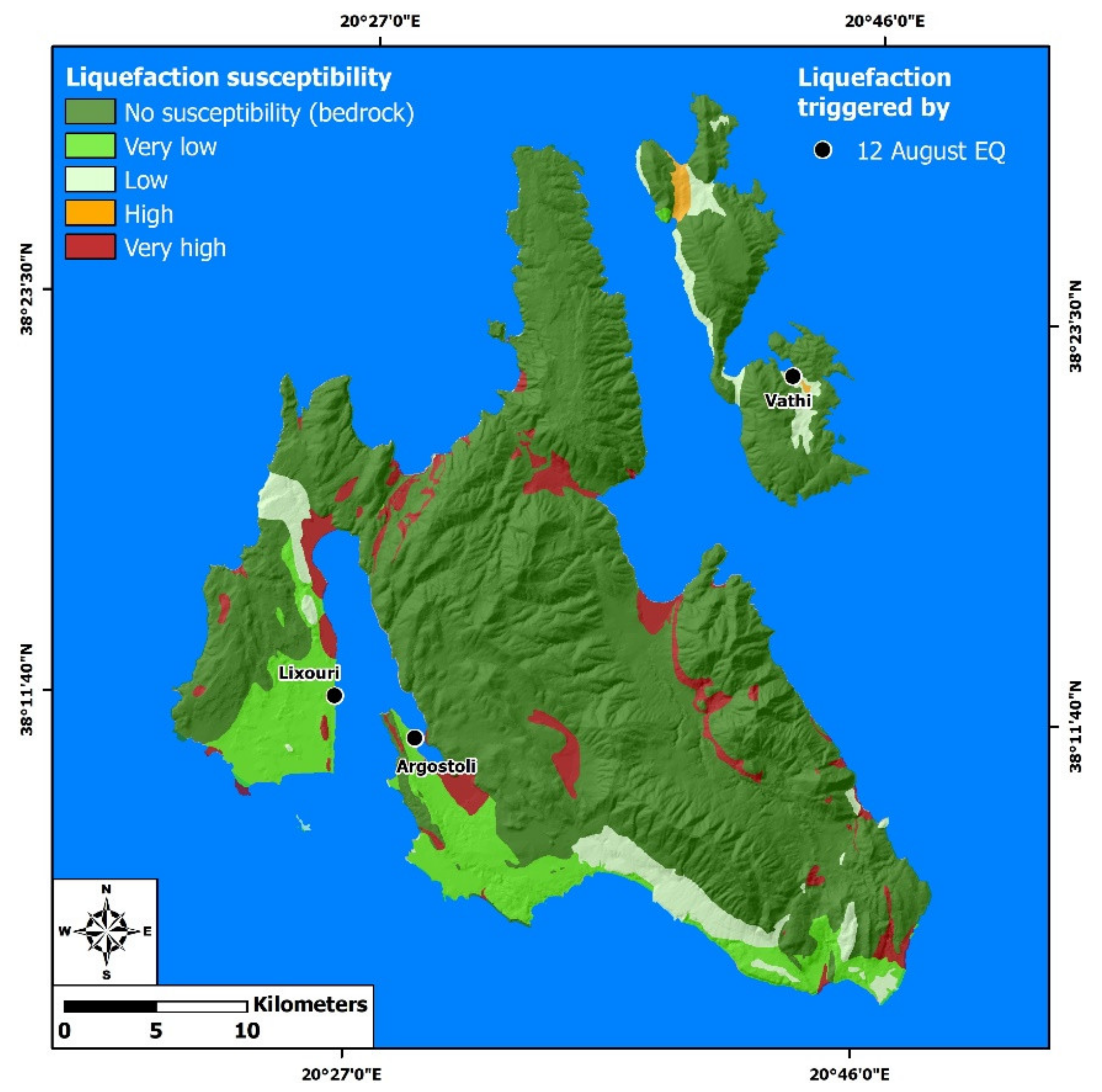
7.3.5. Liquefaction Phenomena

As regards liquefaction, they were observed in Paliki and Argostoli peninsula (Figure 11). Ground cracks were observed along the Lixouri coastal area, resulting in a dipping of the coast towards the sea. Ground cracks and subsidence of about 1 m were observed in the quay of Lixouri. Due to the fact that the walls in the eastern part of the port were submerged [47], it could be concluded that the generated ground cracks in Lixouri port are attributed to lateral spreading. Similar phenomena were also induced in Lixouri coastal area by the early 2014 Cephalonia earthquake sequence [11].
Extensive and deep cracks were also formed along the entire waterfront of Argostoli town, especially in Argostoli port (TAXYDROMOS, 14.08.1953; TA NEA, 12.08.1953, 13.08.1953). These cracks in Argostoli port could be also attributed to liquefaction along the coastal front.
It was not possible to derive further information on liquefaction or related soil failures in other coastal sites of the earthquake-affected Cephalonia Island.

7.3.6. Hydrocarbon-Related Phenomena

The 12 August 1953 also triggered hydrocarbon-related phenomena (Figure 11). Hydrocarbon seepage and combustion was reported along onshore cracks without further available information on the location, while offshore steam emissions were observed in the Argostoli Bay, where the sea seemed like boiling in several parts (TA NEA, 15.08.1953).

7.3.7. Jumping Stones

The phenomenon of jumping stones was also observed [20]. In particular, in the area of Markopoulo village (Figure 11), along the slopes of a limestone hill located south of the village, large boulders (60 m3) received a vertical push, detached from the ground and remained in almost the same position where they had fallen, due to the smoothness of the soil in the area.

7.3.8. Effects on Vegetation

In the aforementioned area of Markopoulo village (Figure 11), effects on vegetation were also observed [20]. The root systems of shrubs and trees were destroyed, resulting in their drying.

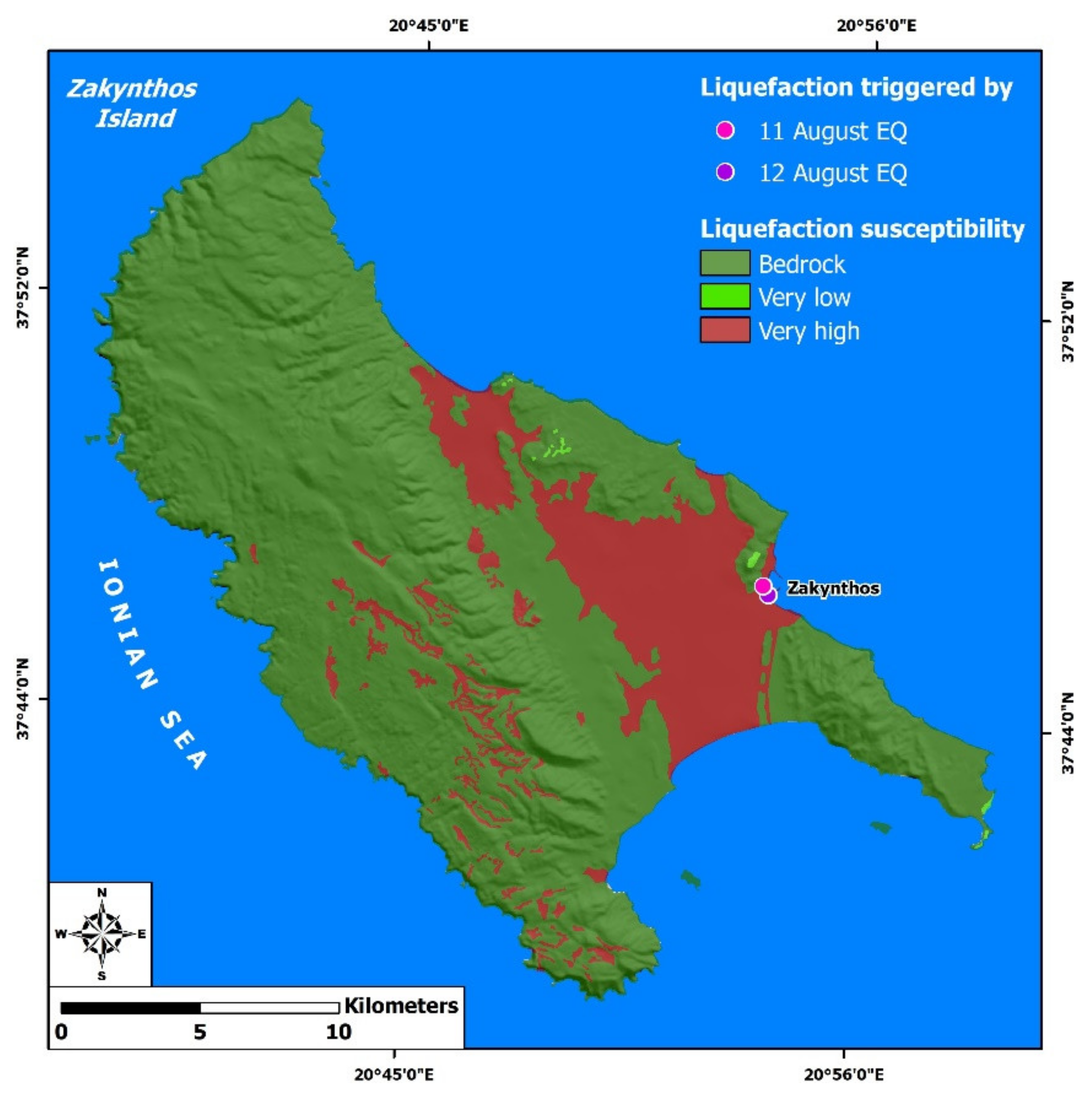
7.4. Environmental Effects Induced by the 12 August 1953 Ionian Sea Earthquake on the Ithaki and Zakynthos Islands

In Ithaki Island, the earthquake-induced effects included slope failures, tsunami and ground cracks (Figure 11; TAXYDROMOS, 13.08.1953, 16.08.1953; TA NEA, 13.08.1953; NEOLOGOS PATRON, 13.08.1953; PELOPONNISOS, 13.08.1953; EMPROS, 14.08.1953; ELEFTHERIA, 15.08.1953; I IMERA, 16.08.1953).
The 12 August 1953 earthquake triggered slope failures in coastal areas of Ithaki Island (Figure 11; TAXYDROMOS, 16.08.1953; NEOLOGOS PATRON, 13.08.1953; TA NEA, 13.08.1953; I IMERA, 16.08.1953). The slope failures were mainly comprised of rockfalls and slides. The volume of the mobilized material was so large, in some sites, that their morphology was altered. In particular, several coasts at the base of affected slopes disappeared under large volumes of mobilized materials (TA NEA, 13.08.1953).
Slope failures were triggered along high and abrupt coastal slopes. In some sites, the mobilized material created dust clouds and fell into the sea resulting in local roughness (NEOLOGOS PATRON, 13.08.1953). The synergy of the dust clouds and the sea roughness gave the impression that large areas were submerged (NEOLOGOS PATRON, 13.08.1953). Further information on the exact location of these effects and the volume of the mobilized material were not available in the studied sources.
Moreover, failures were generated along slopes over Frikes, Lefki and Ayios Ioannis villages (Figure 11; I IMERA, 16.08.1953). The mobilized material accumulated on the adjacent roads and contributed to the complete destruction of heavily affected buildings within the villages (I IMERA, 16.08.1953).
The earthquake triggered tsunami, which affected mainly Vathi in Ithaki Island (Figure 11; EMPROS, 13.08.1953; TAXYDROMOS, 13.08.1953; TA NEA, 13.08.1953; NEOLOGOS PATRON, 14.08.1953). The waves inundated the coast and moved further inland, up to the squares of Vathi (NEOLOGOS PATRON, 14.08.1953). Water marks of small seaweed pieces were left on streets of the town, indicating the extended inundation of the coastal area (TA NEA, 13.08.1953). Some people, found along its course were swept away, but no casualties were reported (NEOLOGOS PATRON, 14.08.1953).
Ground cracks formed in several sites of the road network in Ithaki Island (Figure 11; TAXYDROMOS, 16.08.1953; NEOLOGOS PATRON, 13.08.1953, 14.08.1953; EMPROS, 14.08.1953; I IMERA, 16.08.1953). In particular, they were observed along the road connecting Vathi with the rest of the island (NEOLOGOS PATRON, 13.08.1953) and, more specifically, leading from Vathi to Stavros (EMPROS, 14.08.1953). They were also formed along the pier in Vathi (ELEFTHERIA, 15.08.1953). They were also observed in several sites of northern Ithaki.
The 12 August 1953 triggered environmental effects in Ithaki and Zakynthos Islands (Figure 11 and Figure 12) located northeast and south of the most earthquake-affected Cephalonia respectively. Such effects were not observed in Lefkada, located north of Cephalonia.
In Zakynthos, the 12 August 1953 induced secondary environmental effects including ground cracks, subsidence, lateral spreading and liquefaction phenomena, hydrological anomalies, slope failures and hydrocarbon-related phenomena (Figure 12).
Ground cracks were observed in several sites of Zakynthos town (Figure 12). Its coastal part was intensively deformed by ground cracks, subsidence up to half meter in several sites and submarine landslides resulting in changes in seabed morphology and variation in depth (NEOLOGOS PATRON, 13.08.1953 14.08.1953; I IMERA, 13.08.1953, 14.08.1953; PELOPONNISOS, 16.08.1953; TAXYDROMOS, 16.08.1953). Ground cracks were also observed in sites affected by slope failures, for example in Kokkinos Vrachos (Red Cliff in English) site (Figure 12).
Subsidence was also observed at the area, where the Ayios Dionysios temple had been constructed and at the dock of the town (TA NEA, 13.08.1953; NEOLOGOS PATRON, 13.08.1953). Moreover, water emerged from the foundations of Ayios Dionysios temple (TA NEA, 13.08.1953). The observed effects comprising ground cracks, subsidence and water gushing along the coast and in Ayios Dionysios site could be attributed to earthquake-induced lateral spreading and liquefaction phenomena, respectively (Figure 12).
Hydrological anomalies were also reported in Zakynthos (Figure 12; ELEFTHERIA, 13.08.1953). Water turbidity was noticed in wells, while springs run dry in several sites in Zakynthos town (I IMERA, 13.08.1953).
Slope failures were also affected the same area. In particular, rockfalls were triggered in Kryoneri area (Figure 12), resulting in the destruction of the adjacent road network and the complete destruction of the Krio Nero* (Cold Water in English) spring (ELEFTHERIA, 13.08.1953; TAXYDROMOS, 14.08.1953), which could be used to put out the raging fires burning across Zakynthos town for days after the earthquake. Moreover, rockfalls and landslides were generated along the slopes of Skopos Mt and Mikros Aenos Mt surrounding Zakynthos town (Figure 12; TAXYDROMOS, 14.08.1953).
Information for earthquake environmental effects in the rest of the island are not available due to the fact that slope failures and ground cracks resulted in destruction of the road network, thus communication with the rest of the island became impossible. The only available information came from a reconnaissance flight, during which extensive rockfalls were reported along abrupt coastal slopes in the northern part of Zakynthos Island (Figure 12; ELEFTHERIA, 15.08.1953; TO VIMA, 15.08.1953).
The sea was also affected by the generation of the earthquake and its level in the coastal area of Zakynthos town was raised (TO VIMA, 13.08.1953). Sulfur gas emissions were also noticed in Zakynthos town, without further information on the exact location of the effect.

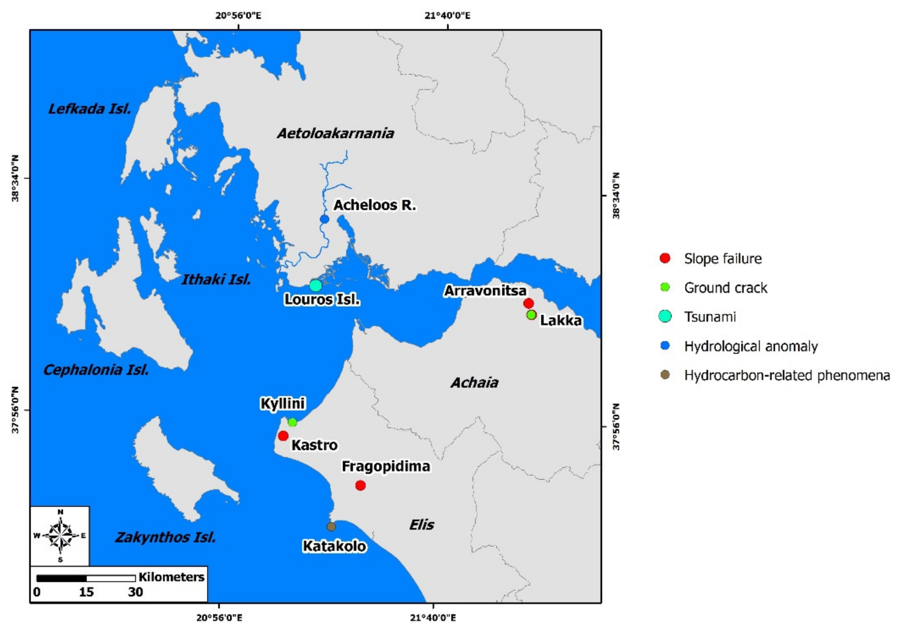
7.5. Far-Field Effects Induced by the 11 and 12 August 1953 Earthquakes
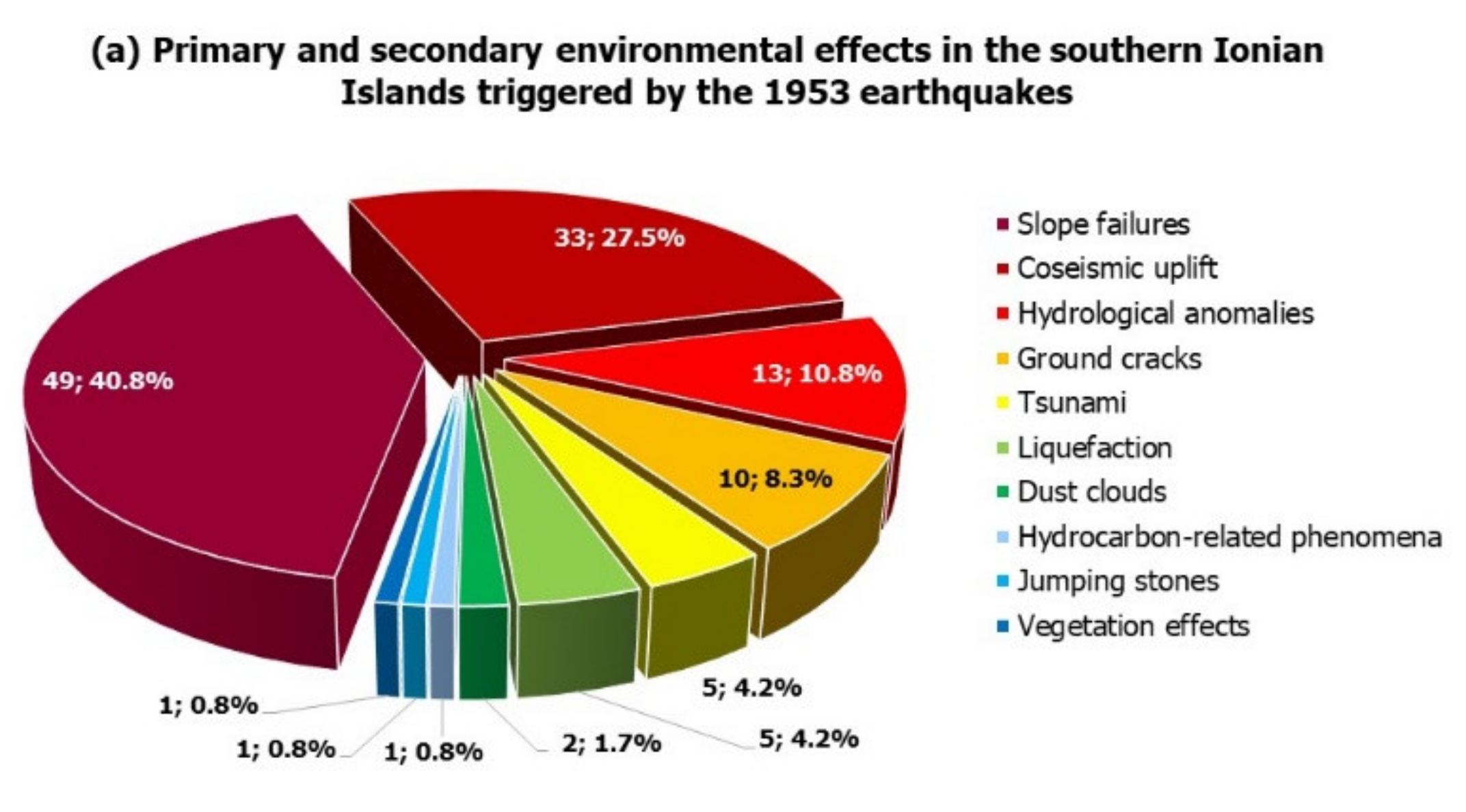
Far-field effects were detected in several sites in the adjacent Aetoloakarnania area and in the Peloponnese by the 11 and 12 August earthquakes (Figure 13).
Slope failures were generated by the 11 August earthquake in Kyllini peninsula located at the northwestern coastal part of Peloponnese (Figure 13). They were reported at a distance of about 4 km from oil exploration drillings in the area and the mobilized material was several tons (PELOPONNISOS, 12.08.1953).
The 12 August 1953 earthquake induced also far fields effects including in tsunami, hydrological anomalies and slope movements (Figure 13). Moreover, environmental effects related to hydrocarbon release were also detected few days after the earthquake (Figure 13).
More specifically, the Louros islet, located southwest of Aetoliko area in the adjacent Aetoloakarnania region (Figure 13), was covered by the sea waves during the earthquake (NEOLOGOS PATRON, 13.08.1953).
Also, in Aetoloakarnania, the Acheloos River diverted its course as a result of the earthquake and later returned to its normal bed (I IMERA, 14.08.1953; NEOLOGOS PATRON, 14.08.1953). The diversion was detected in the area between Palaeokastro and Aggelokastro (Figure 13) towards Katochi town and resulted extensive flooding of agricultural land, comprised of rice and vegetable crops.
Slope failures were also generated along the slopes of the Foinikas River gorge located at the northern part of Panachaiko Mt in northern Peloponnese (Figure 13; NEOLOGOS PATRON, 15.08.1953). In particular, northwest of the Arravonitsa plateau (Figure 13), a large volume of unstable rocks detached and fell towards the Foinikas River, resulting in a wide opening. Slope failures were also generated closed to Lakka village located southeast of Arravonitsa village (Figure 13). Unstable material were detached from the bed rock and fell into the adjacent valley for 100 m. Ground cracks were also formed in the same area. Both sites affected by the slope movements are located along the seismogenic fault of the Southern Corinth Gulf, based on the Greek Database of Seismogenic Sources [39].
Far field effects by the 12 August 1953 earthquakes were also reported in western Peloponnese (Figure 13). They comprised slope failures, ground cracks and hydrocarbon-related effects (AKROPOLI, 1953; NEOLOGOS PATRON, 20.08.1953).
Slope failures were observed along slopes in Fragkopidima area located in the western Peloponnese, north of Vounargo village (Figure 13; AKROPOLI, 1953). Ground cracks were observed in the Kyllini beach in western Peloponnese (Figure 13; AKROPOLI, 1953). Hydrocarbon related effects were observed in Katakolo area of western Peloponnese (Figure 13; NEOLOGOS PATRON, 20.08.1953; ELEFTHERIA, 20.08.1953, 21.08.1953; 22.08.1953; TAXYDROMOS, 23.08.1953). Sulphureous gas emissions and subsequent flames about 1 m high coming out of a pre-existing crater were observed in Psorochoma site 8 days after the 12 August 1953. The flames were observed during both day and night and illuminated an area with a radius of 200 m. These phenomena indicate combustion of natural gas, which escaped from the crater. Prior to these effects, a light stream of air came out of the crater, which extinguished a lighted match without ignition.
Similar hydrocarbon-related effects were also triggered by historical earthquakes in Zakynthos Island, located west of the Katakolo area. Sulphureous gas emission and flames were also triggered by the 1633, 1791, 1809, 1820 and 1840 earthquakes in Zakynthos [15]. The occurrence of asphalt–pitch seepages and sulphureous gas emissions are associated with existing hydrocarbon deposits in both areas (Katakolo area and Zakynthos Island) [50,51].

8. Results

8.1. Types and Causative Earthquakes of the Detected Effects

Based on the study of the 9, 11 and 12 August 1953 earthquakes, 120 cases of environmental effects were totally detected in the southern Ionian Islands. Thirty-three cases of primary effects were induced by the 12 August 1953 earthquake (27.5% of the triggered effects), while 87 cases of secondary ones were generated by all three earthquakes (72.5% of the triggered effects) (Figure 14a). The primary ones included 33 cases of permanent coseismic surface deformation (uplift, 27.5%), while the secondary ones included 49 cases of slope failures (40.8%), 13 cases of hydrological anomalies (10.8%), 10 cases of ground cracks (8.3%), 5 of anomalous waves/tsunami (4.2%), 5 of liquefaction (4.2%), 2 of dust clouds (1.7%) as well as a case of jumping stones (0.8%) and a case of effects on vegetation (0.8%) (Figure 14a). A case of hydrocarbon-related effects was also detected (0.8%) (Figure 14a).
The studied earthquakes also triggered far-field effects in Aetoloakarnania comprising a case of hydrological anomalies and a case of anomalous sea waves, in Achaia, including two cases of slope failures and a case of ground cracks, as well as in Elis comprising two cases of slope failures, a case of ground cracks and a case of hydrocarbon-related phenomena.
As regards the causative earthquake, it is concluded that the majority of the detected earthquake environmental effects were triggered by the 12 August 1953 mainshock. In particular, 7 cases of secondary effects were triggered by the 9 August earthquake (5.8% of the 120 effects; Figure 14b), 15 cases of secondary effects triggered by 11 August earthquake (12.5%; Figure 14c), 65 cases of secondary effects (54.2%) were triggered by the 12 August earthquake (Figure 14d).
It became clear from the aforementioned data that the majority of the detected environmental effects included by the studied August 1953 earthquakes were distributed close to residential areas including villages and towns. These effects were characterized by a high location reliability. As we moved away from residential areas, the exact location and the qualitative and quantitative information of the triggered effects became more difficult to identify, resulting in lower location reliability. Moreover, a lack of information was observed in remote areas. This fact could be attributed to the impact of the triggered effects that caused severe damage to the road network and subsequent traffic and communication disruption resulting in isolated areas difficult-to-impossible to reach during the first hours, days and weeks after these destructive earthquakes. A characteristic example is Zakynthos Island, where information about earthquake environmental effects are available for the homonymous town in the eastern part of the island, while information for the rest of the island are missing. This lack is attributed mainly to the destruction of the road network leading from the coastal Zakynthos town to the inland part of the island, which could also have been affected by the 1953 earthquakes, but not reported in the aforementioned sources and secondarily to the low preservation potential of the triggered effects in inland Zakynthos.
As regards the reliability of the detected sites, taking into account the results from assigning the location reliability index in all sites affected by primary and secondary environmental effects, it is concluded that 74.2% (89 out of 120) of the triggered effects are classified into the first class (0–100 m), while 20.8 % (25 out of 120) into the second class (0–1 km), 2.5% (3 out of 120) into the third class (0–10 km) and 2.5% (3 out of 120) into the four class (>10 km) (Figure 15). So, it could be suggested that the locations detected in the frame of this study are reliable.

8.2. Distribution of the Detected Effects in Fault Blocks

In Cephalonia, the effects were generated and distributed to all fault blocks of the island comprising the Erissos, Paliki and Argostoli peninsulas, the Aenos Mt and the southeastern Cephalonia. Particularly, coseismic uplift was generated along the eastern coastal part of the fault block of Aenos Mt, along the northern coastal part of Argostoli peninsula, at the northwestern coastal end of the transition zone from the Erissos peninsula to the Aenos Mt fault block and at the northern coastal part of Paliki peninsula. Slope failures were mainly triggered along steep slopes, which are characterized by instability conditions favorable for the triggering of slides and rockfalls, in the case of strong earthquake ground motion. In Cephalonia, these zones include the transition zone from Erissos peninsula to the Aenos Mt fault block, the transition zone from the Aenos Mt fault block to Paliki peninsula, the southern slopes of Aenos Mt, which are characterized by considerable uplift and intense incision, as well as along steep slopes within the aforementioned fault blocks. Hydrological anomalies were detected in residential areas located within the Aenos fault block and in the northwestern part of Argostoli peninsula, where wells and springs were used for water supply. Ground cracks were mainly formed close to sites affected by slope failures and liquefaction phenomena. Anomalous waves/tsunami mainly affected funnel-shaped bays, including Argostoli bay in Cephalonia. Liquefaction was limited to port areas and sites close to the seashore, which are composed of late Holocene deposits susceptible to liquefaction. The other effects comprising dust clouds, vegetation effects and hydrocarbon-related phenomena were also observed in areas strongly affected by the earthquake ground motion.
As regards Ithaki, the induced effects were distributed to the central and the southern fault blocks of the island. Slope failures and ground cracks were generated in the central and the southern fault blocks, while anomalous sea waves/tsunami and hydrological anomalies in the southern fault block. In Zakynthos, the triggered effects were limited to the coastal Zakynthos town and the adjacent Skopos Mt.
Far-fields effects were also triggered in the adjacent Aetoloakarnania and the Peloponnese and comprised hydrological anomalies and tsunami in Aetoloakarnania, slope failures and ground cracks in Achaia and slope failures, ground cracks and hydrocarbon-related phenomena in Elis.

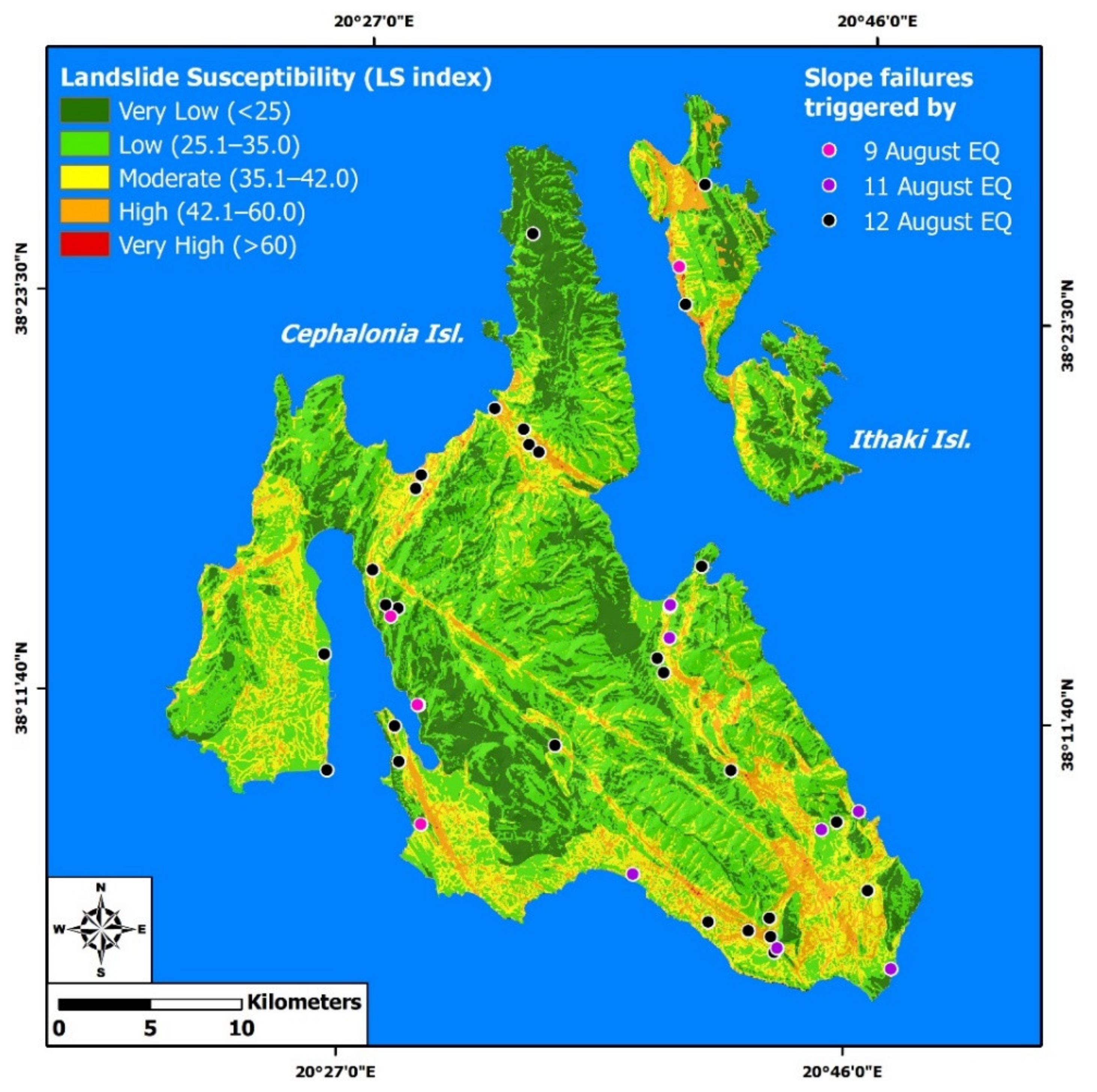
8.3. Distribution of Effects on Susceptible Zones

In order to determine whether or not they were randomly distributed in the aforementioned fault blocks, we compared the inventory of effects with susceptibility maps, illustrating areas of the southern Ionian Islands susceptible and vulnerable to their generation.

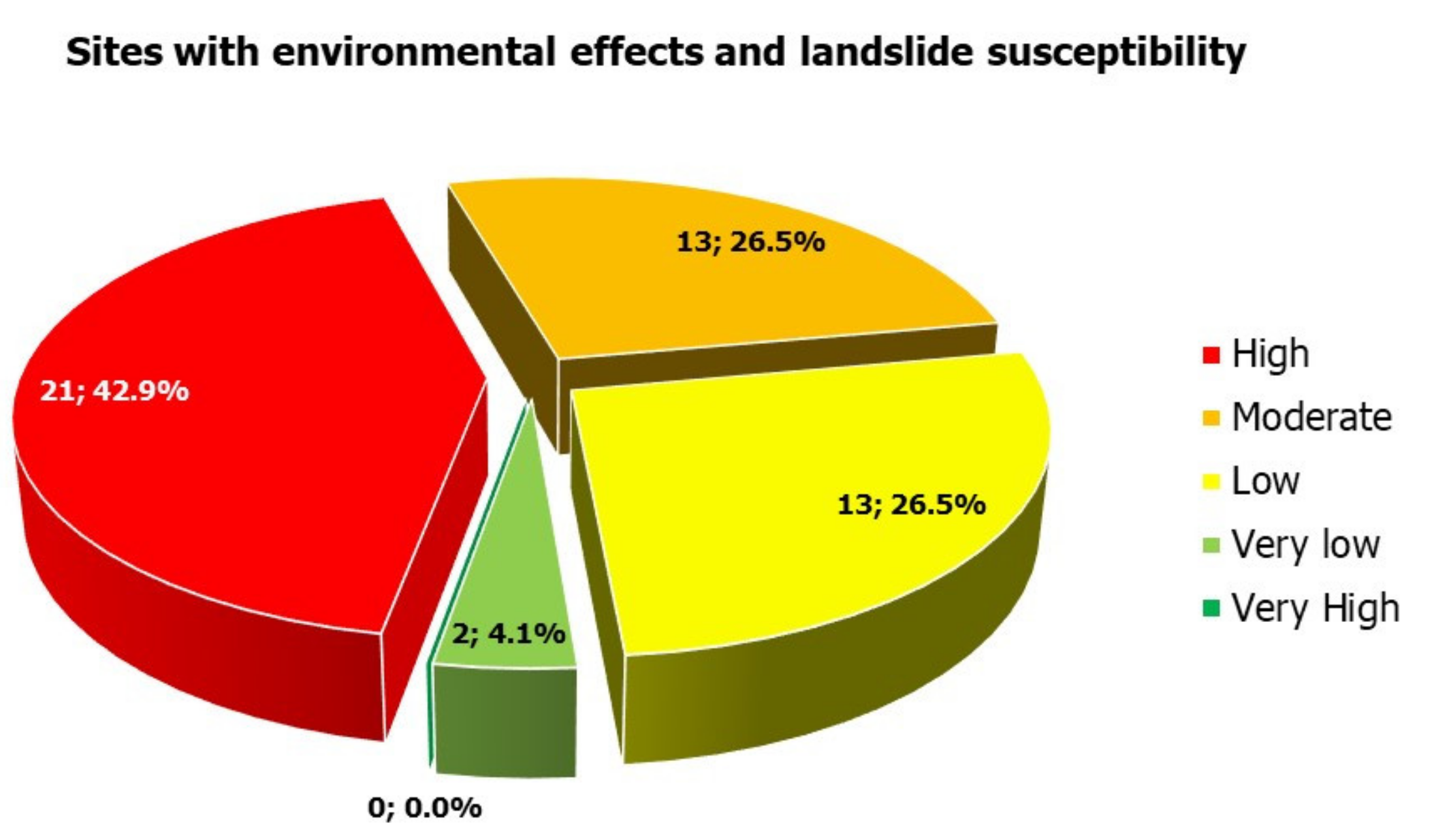
8.3.1. Slope Failures

Slope failures constituted about 40.8% of the detected effects in the southern Ionian Islands and were the dominant effects triggered by the studied 1953 earthquakes. Slope failures were distributed on several lithologies, which were obtained from the respective neotectonic maps presented in Figure 16. 24 slope failures were generated in post-alpine deposits (49% of the total failures) and 25 in alpine formations of Paxoi and Ionian units (51% of the total failures) (Figure 16a). The majority of slope failures (22 out of 49, 44.9%) were triggered in carbonate rocks, comprising Triassic–Middle Miocene limestones of the Paxoi unit (14 failures, 28.6%) and Jurassic–Cretaceous limestones of the Ionian unit (7 failures, 14.3%) in Cephalonia as well as the Upper Cretaceous limestones of Paxoi unit (1 failure, 2.0%) in Zakynthos (Figure 16b).
The next-most affected lithologies are comprised of interglacial deposits of Middle Pleistocene age (8 failures, 16.7%) and scree and talus cones of Middle Pleistocene age (7 failures, 14.3%) (Figure 16b), all located on Cephalonia island. As regards the type of the triggered slope failures, we conclude that the majority were rockfalls (46 failures out of 49, 93.9%), while mixed-types, consisting of slides and rockfalls, were also triggered (3 failures out of 49, 6.1%).
Regarding the impacts on the built environment of the southern Ionian Islands, several rockfalls considerably affected buildings in villages, resulting in greater fatalities and injuries. Characteristic examples are Tzanata, Chionata, Plateies and Anninata villages, where rockfalls triggered by the 11 and 12 August earthquakes increased the number of fatalities and injured people; Kourouklata, Valsamata and Kolaitis villages, which were completely destroyed by rockfalls generated by the 12 August 1953 earthquake; as well as Zervata, Katapodata, Atsoupades, where rockfalls induced by the 12 August mainshock caused extensive structural damage to their buildings. Beyond these effects, slope failures affected also the livestock in several villages and vegetation, including mainly olive groves and vineyards.
As regards the spatial distribution of slope failures, the landslide susceptibility maps of the Ionian Islands compiled in the frame of the project titled “Telemachus—Innovative Operational Seismic Risk Management System of the Ionian Islands” [Priority Axis “Environmental Protection and Sustainable Development” of the Operational Programme “Ionian Islands 2014–2020”] [52,53,54] were used. For the compilation of the maps, various factors were taken into account, which favor the occurrence of slope failures, including slope, aspect, curvature, lithology, proximity to faults, roads and streams, soil thickness and land use. The analytical hierarchy process was used, along with the weighted linear combination method, in the framework of a multicriteria decision analysis for the calculation of the landslide susceptibility index (LSI). The result of this approach is the landslide susceptibility map of the Ionian Islands, shown in Figure 17.
By comparing slope failures induced by the studied 1953 earthquakes in the southern part of the Ionian Islands with the respective susceptibility maps for Cephalonia, Ithaki and Zakynthos, it is concluded that the largest percentage of slope failures (42.9%) were generated in zones characterized by high susceptibility (LSI = 42.1–60), while 26.5% of slope failures were induced in zones with moderate susceptibility (LSI = 35.1–42), 26.5% in zones with low susceptibility (LSI = 25.1–35) and 4.1% in zones with very low susceptibility (LSI < 25) (Figure 17 and Figure 18).
The highly susceptible zones correspond to the transition zone from the fault block of the Erissos peninsula to the fault block of the Aenos Mt, to the transition zone from the fault block of the Aenos Mt to the fault block of Paliki peninusla, to the steep southern slopes of Aenos Mt and to the western slopes of Avgo Mt located east of Sami area. These zones are dominated by major faults and fault zones forming impressive morphological discontinuities defined by high and steep slopes and reducing the mechanical properties of the faulted formations. Thus, it can be concluded that the August 1953 earthquake-induced slope failures were structurally controlled.

8.3.2. Liquefaction Phenomena

As regards the distribution of liquefaction phenomena, the liquefaction susceptibility maps of the Ionian Islands prepared for the “Telemachus” project [52] and updated by Mavroulis [55] were used. The classification of the geological formations into zones susceptible to liquefaction was based on geological criteria, including the age and the depositional environment of the formations and seismological criteria comprising the peak ground acceleration (PGA). The geological formations of the southern Ionian Islands were classified into five categories [52,55] (Figure 19): (1) The very highly susceptible to liquefaction deposits comprised of Late Holocene deposits in areas with PGA equal to 0.36 g, Late Holocene and Holocene deposits in areas with PGA equal to 0.24 g and 0.36 g respectively and deposits in areas with a history of earthquake-induced liquefaction occurrence. (2) The highly susceptible to liquefaction deposits comprised of Late Holocene and Holocene deposits in areas with PGA equal to 0.24 g and 0.36 g respectively characterized by earthquake-induced liquefaction history. (3) The deposits of medium liquefaction susceptibility, including Late Holocene and Holocene deposits, in areas with PGA equal to 0.16 g and 0.24 g respectively. (4) The deposits of low liquefaction susceptibility comprised of Pleistocene deposits in areas with PGA equal to 0.36 and 0.24 g. (5) The deposits of very low liquefaction susceptibility comprised of Pleistocene deposits in areas with PGA equal to 0.16 g. Geological formations older than the Pleistocene are not susceptible to liquefaction [56]. A similar approach to this liquefaction-susceptibility mapping has been recently applied in areas with similar geological and seismological properties, namely the case of the coastal area of Durrës in Albania after the 26 November 2019, Mw = 6.4 earthquake [57].
From the spatial distribution of the liquefaction phenomena and the zones susceptible to liquefaction, it is concluded that these effects occurred in zones with high and very high susceptibility. These zones correspond to coastal areas, which are mainly composed of recent deposits and host port facilities affected by the earthquakes. However, the ports remained operational during the response to the 1953 earthquake emergency.

8.3.3. Anomalous Sea Waves/Tsunami

Despite the fact that the southern Ionian Islands have been mainly affected by strike–slip earthquakes, considered insufficient for triggering tsunami, Mavroulis identified 26 historical and recent earthquakes with subsequent anomalous sea waves/tsunami with mild-to-moderate impacts on the coastal natural and built environment of the southern Ionian Islands [55]. These effects could be attributed either to seabed displacements and ruptures accompanying strike–slip earthquakes or submarine and coastal slope failures triggered by the earthquakes’ ground motion [58,59,60,61]. Moreover, Mavroulis concluded that the most susceptible areas in the southern Ionian Islands to tsunami effects are the coastal areas of funnel-shaped bays and of narrow straits [55]. Such susceptible areas comprise: (a) in Cephalonia, the eastern coastal Erissos peninsula, the eastern coastal Paliki peninsula, the western and northeastern coastal parts of the Aenos Mt fault block and the Argostoli Bay, (b) in Ithaki, the Vathi Bay and the western coastal part of the island and (c) in Zakynthos, the coastal area of the homonymous city and the coastal part of Laganas Gulf. Among these areas, the anomalous waves/tsunami reported after the generation of the August 1953 earthquakes affected the coastal area of Argostoli Bay in Cephalonia, of Vathi Bay in Ithaki and of Zakynthos city in the homonymous island.

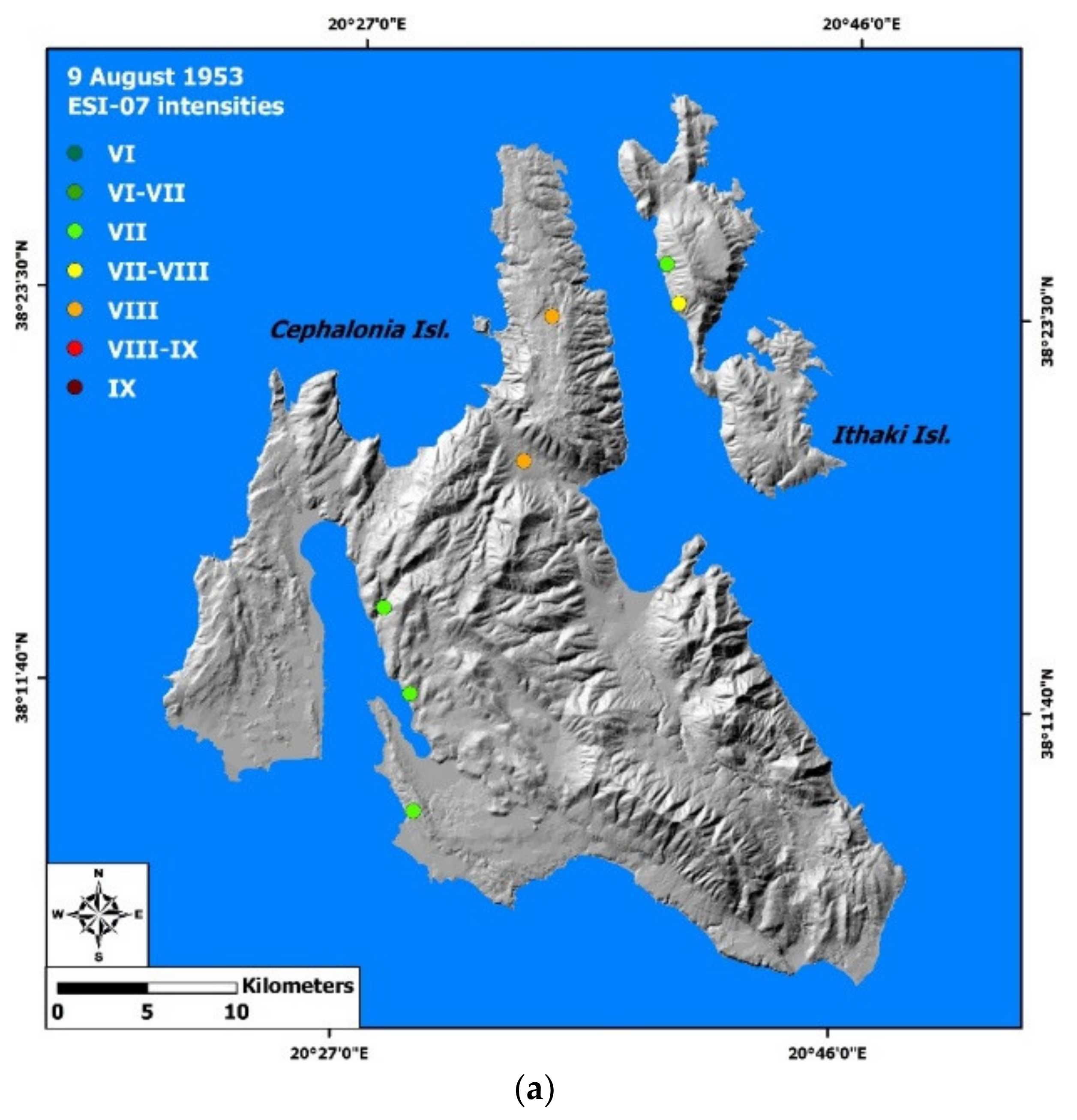
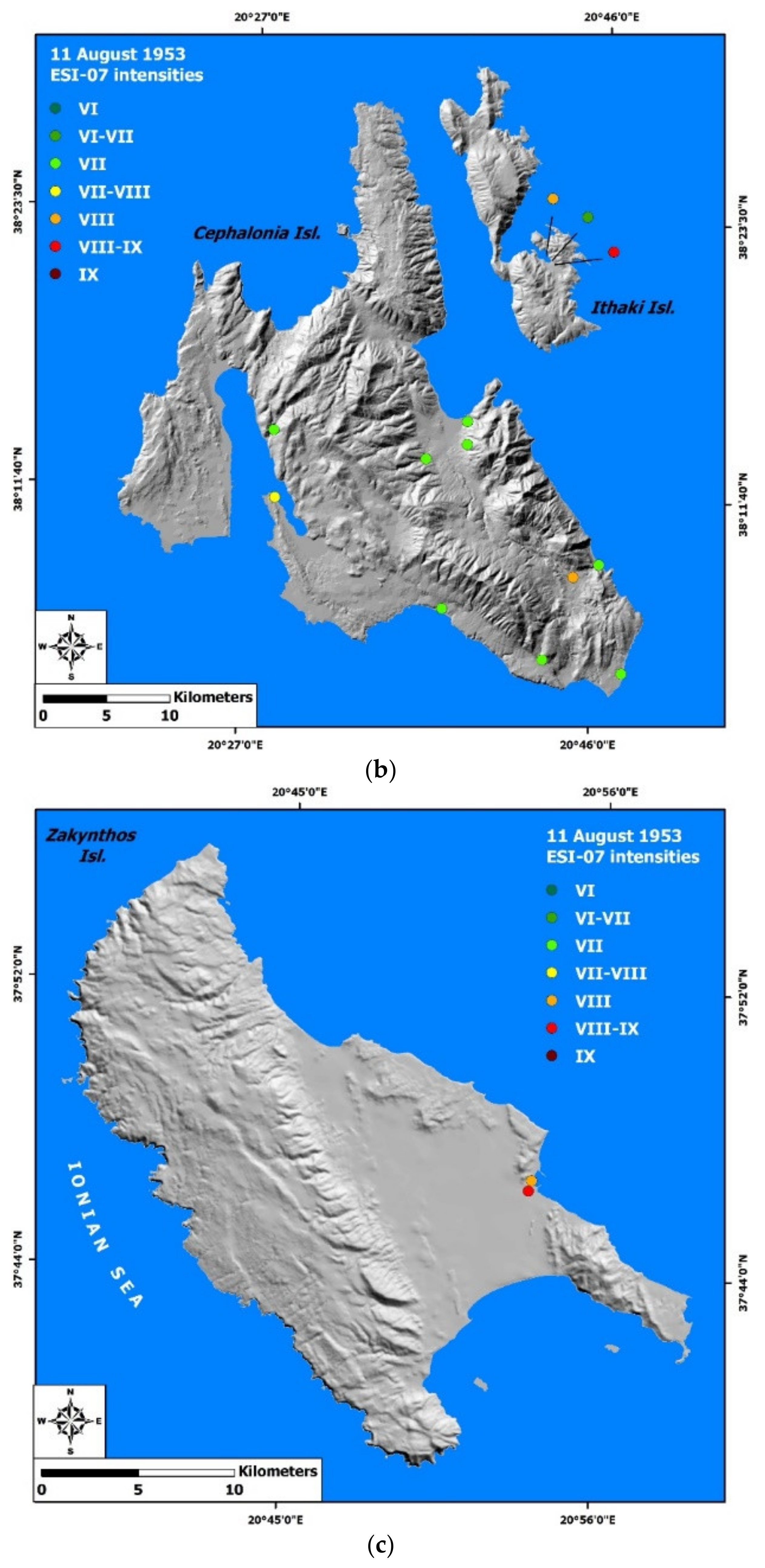
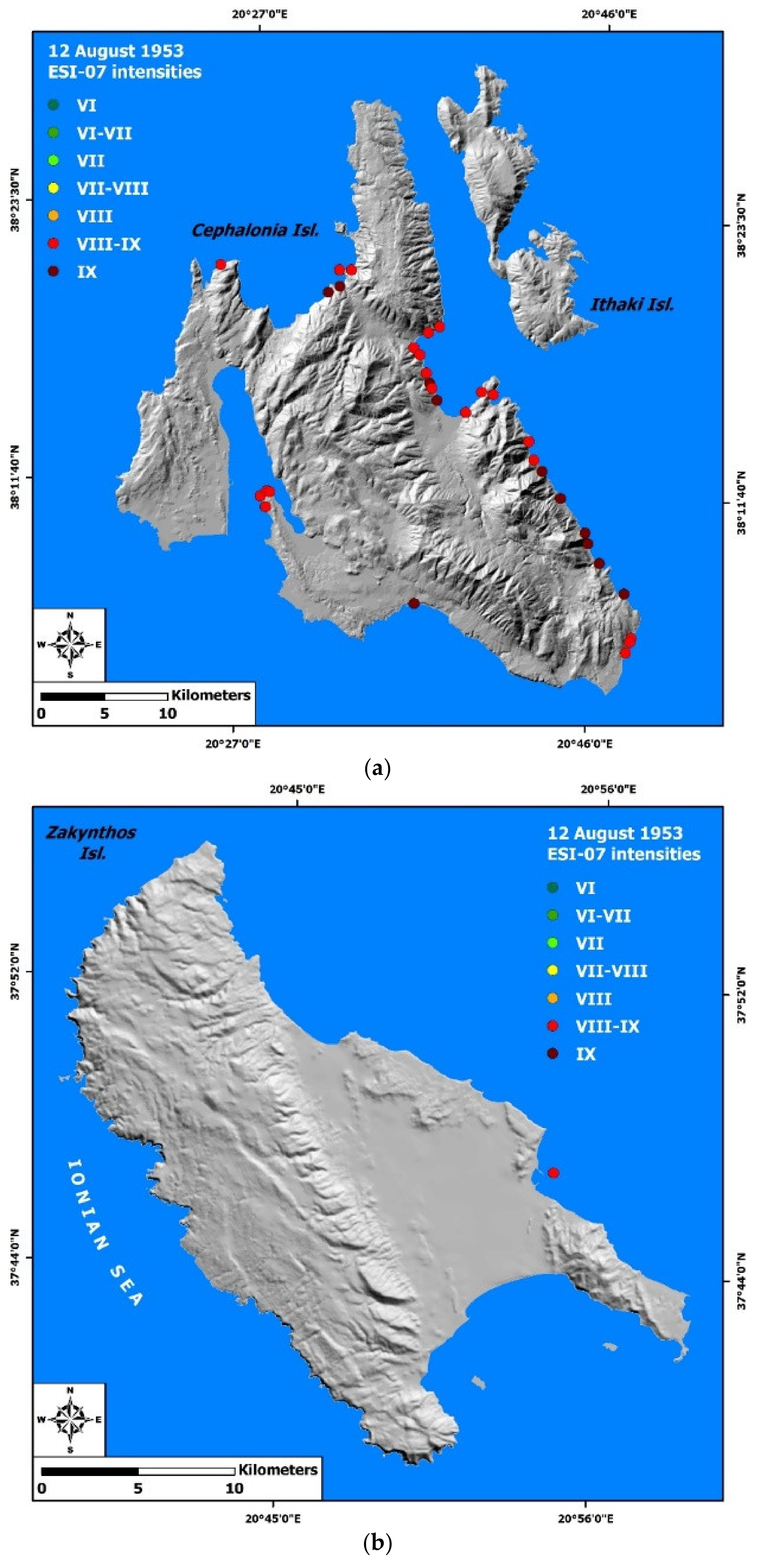
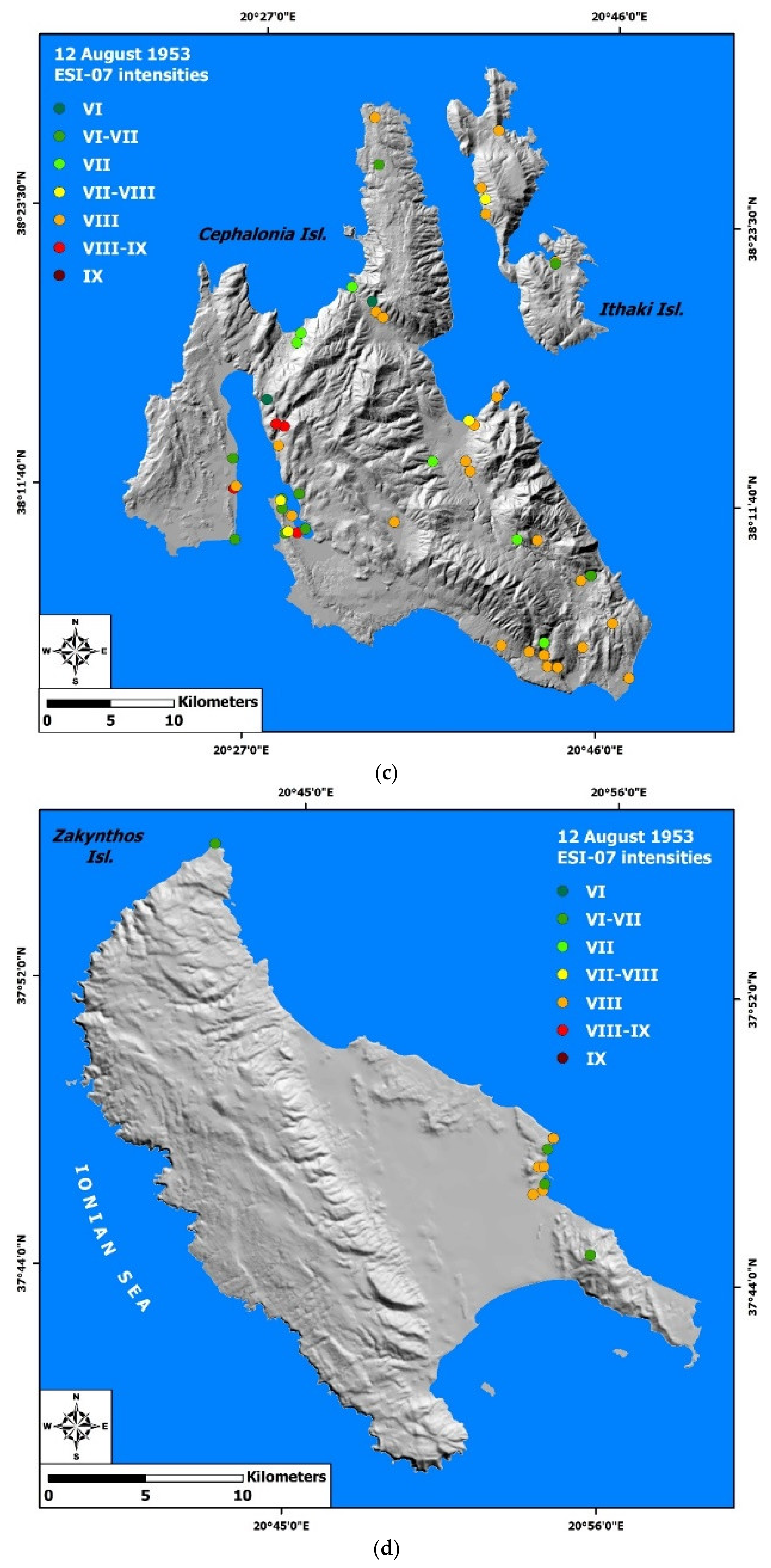
9. ESI-07 Intensities

Environmental seismic intensities were assigned to all sites affected by environmental effects triggered by the mainshock of 12 August 1953 and its foreshocks on 9 and 11 August (Figure 20 and Figure 21), taking into account the available qualitative and quantitative information and the guidelines of Michetti et al. [30]. A table with all related information on the ESI-07 scale application is presented as Supplementary material (Table S1). This table has several fields, including the causative earthquake, the location of the induced effect, including the affected island, fault block and site, the category and the description of the induced effect, its impact on the built environment and on the local population, the respective ESI-07 intensity, the source of the information and its reliability index.
The highest assigned intensities are VIIIESI-07 for the first earthquake, VIIIESI-07 for the second earthquake and IΧESI-07 for the third earthquake (Figure 20 and Figure 21). The environmental seismic intensities assigned to primary effects range from VIII-IXESI-07 to IXESI-07, to slope failures from VIESI-07 to IXESI-07, to hydrological anomalies from VIIESI-07 to VIII-IXESI-07, to ground cracks from VI-VIIESI-07 to VIIIESI-07 and to anomalous sea waves/tsunami from VIESI-07 to VIIIESI-07. The intensity assigned to liquefaction, dust clouds, jumping stones and vegetation effects is VIIIESI-07. No intensities were assigned to the far-field effects.
The highest intensities of the first earthquake in Cephalonia were assigned to Pylaros and Erissos areas in the northern part of Cephalonia, as well as in the northern part of Ithaki (Figure 20a). The highest intensities of the second earthquake were assigned to the southeastern part of Cephalonia (Figure 20b), to Vathi Bay area in Ithaki (Figure 20b) and to the coastal part of Zakynthos town (Figure 20c). The highest intensities of the third earthquake were assigned to sites in Cephalonia with detected coseismic uplift (Figure 21a,b), especially to the eastern coastal part of the Aenos Mt fault block from the Sami bay to the Skala area, to the Myrtos coastal area, to the northern part of Paliki peninsula and to the northern end and the southern part of the Argostoli peninsula. Furthermore, highest intensities were assigned to sites affected by secondary effects, the Lixouri, Argostoli and Kourouklata areas in Cephalonia (Figure 21c), the northern part of Ithaki (Figure 21c) and the area of Zakynthos town in the homonymous island (Figure 21d).

10. Conclusions

To date, special attention has been paid to the effects of the mainshock on 12 August 1953 and its foreshocks on 9 and 11 August in the built environment of the southern Ionian Islands, and to the impact on the local population. That is absolutely justified, as these events along with other hazards (mainly slope failures and subsequent fires) devastated the southern Ionian Islands resulting in the largest earthquake-related human losses in the post-war history of Greece.
In the frame of this study, emphasis was placed on the earthquake environmental effects on the southern Ionian Islands by using a wider range of sources with a wealth of relevant information. The analysis of these sources allowed the reconstruction of a representative distribution of the environmental effects triggered by the 1953 earthquakes, which was not available so far.
The earthquakes on 9, 11 and 12 August 1953 in the southern Ionian Islands triggered plethora of primary and secondary environmental effects in Cephalonia, Ithaki and Zakynthos Islands. In particular, the primary effects included permanent coseismic surface deformation (uplift), while the secondary included slope failures, hydrological anomalies, ground cracks, anomalous waves/tsunamis, liquefaction phenomena, dust clouds, jumping stones, impact on vegetation and hydrocarbon-related effects. They also caused far-field effects, in the adjacent Aetoloakarnania and in the northwestern and the central–western Peloponnese.
From the correlation of the inventory of the earthquake environmental effects and the susceptible zones, it is concluded that the majority of these effects were not randomly distributed in the affected islands but occurred in specific zones with characteristics and properties that made them susceptible to the occurrence of earthquake-related hazards. The zones affected by slope failures are characterized by intense morphology with high and steep slopes, attributed to strong uplift and intense incision. They are composed of various lithologies and are mainly located along marginal faults, which have contributed to a significant reduction of the mechanical strength of the faulted formations. The zones where liquefaction phenomena have occurred are found in coastal areas composed of recent deposits, particularly susceptible to such phenomena during strong earthquake ground motion. The zones affected the most by anomalous waves/tsunami were the coastal parts with funnel-shaped gulfs in the affected southern Ionian Islands. Large-scale tsunami and related effects were not generated on the coast, but anomalous waves with high potential for mild or moderate effects were triggered and reported in this strike–slip environment. Onshore hydrological anomalies were identified in water bodies, including lakes and in ground water extraction works, such as wells in residential and rural areas, which indicated a wide earthquake-induced disturbance of the aquifer.
This information and the study in its entirety was of great value in reconstructing the type and the distribution of the triggered effects of, and to better estimate the impact of, the most destructive seismic event in the recent history of Greece. Moreover, it outlines the type, the distribution and the intensity of the earthquake-related hazards and the impact of a similar future occurrence in a region that has seen strong urban and infrastructural growth since then, as well as in other areas with similar geological and seismological setting and properties.

Supplementary Materials

The following are available online at www.mdpi.com/article/10.3390/app11188429/s1, Table S1: Primary effects induced by the August 1953 Ionian Sea earthquakes in the southern Ionian Islands and related ESI-07 intensities; Table S2: Secondary effects induced by the August 1953 Ionian Sea earthquakes in the southern Ionian Islands and related ESI-07 intensities.

Author Contributions

Conceptualization, S.M. and E.L.; methodology, S.M.; validation, S.M.; formal analysis, S.M.; investigation, S.M.; data curation, S.M.; writing—original draft preparation, S.M.; writing—review and editing, S.M. and E.L.; visualization, S.M.; supervision, E.L. All authors have read and agreed to the published version of the manuscript.

Funding

This research received no external funding.

Institutional Review Board Statement

Not applicable.

Informed Consent Statement

Not applicable.

Acknowledgments

This work comprises part of the unpublished PhD Thesis of Spyridon Mavroulis titled “Environmental effects and assessment of environmental intensities of historical and recent earthquakes in Western Greece (Western Peloponnese and Central Ionian Islands) and correlation with active tectonics and seismological parameters” and completed in 2020 in the National and Kapodistrian University of Athens. Three anonymous reviewers are acknowledged for their constructive comments and suggestions to improve the manuscript.

Conflicts of Interest

The authors declare no conflict of interest.

References

  1. Scordilis, E.M.; Karakaisis, G.F.; Karacostas, B.G.; Panagiotopoulos, D.G.; Comninakis, P.E.; Papazachos, B.C. Evidence for transform faulting in the Ionian sea: The Cephalonia island earthquake sequence of 1983. Pure Appl. Geophys. PAGEOPH 1985, 123, 388–397. [Google Scholar] [CrossRef]
  2. Louvari, E.; Kiratzi, A.; Papazachos, B. The Cephalonia Transform Fault and its extension to western Lefkada Island (Greece). Tectonophysics 1999, 308, 223–236. [Google Scholar] [CrossRef]
  3. Sachpazi, M.; Hirn, A.; Clément, C.; Haslinger, F.; Laigle, M.; Kissling, E.; Charvis, P.; Hello, Y.; Lépine, J.-C.; Sapin, M.; et al. Western Hellenic subduction and Cephalonia Transform: Local earthquakes and plate transport and strain. Tectonophysics 2000, 319, 301–319. [Google Scholar] [CrossRef]
  4. Lekkas, E.; Danamos, G.; Lozios, S. Neotectonic structure and evolution of Lefkada island. Bull. Geol. Soc. Greece 2001, 34, 157–163. [Google Scholar] [CrossRef] [Green Version]
  5. Lekkas, E.; Danamos, G.; Mavrikas, G. Geological Structure and Evolution of Kefallonia and Ithaki islands. Bull. Geol. Soc. Greece 2001, 34, 11–17. [Google Scholar] [CrossRef]
  6. Kokinou, E.; Kamberis, E.; Vafidis, A.; Monopolis, D.; Ananiadis, G.; Zelilidis, A. Deep seismic reflection data from offshore western greece: A new crustal model for the ionian sea. J. Pet. Geol. 2005, 28, 185–202. [Google Scholar] [CrossRef]
  7. Kokinou, E.; Papadimitriou, E.; Karakostas, V.; Kamberis, E.; Vallianatos, F. The Kefalonia Transform Zone (offshore Western Greece) with special emphasis to its prolongation towards the Ionian Abyssal Plain. Mar. Geophys. Res. 2006, 27, 241–252. [Google Scholar] [CrossRef]
  8. Margaris, B.; Papaioannou, C.; Theodulidis, N.; Savvaidis, A.; Anastasiadis, A.; Klimis, N.; Makra, K.; Demosthenous, M.; Karakostas, C.; Lekidis, V.; et al. Preliminary Observations on the August 14, 2003 Lefkada Island (Western Greece) Earthquake. EERI Special Earthquake Report; Joint Report by Institute of Engineering Seismology and Earthquake Engineering, National Technical University of Athens and University of Athens; EERI: Oakland, CA, USA, 2003; pp. 1–12. [Google Scholar]
  9. Lekkas, E.; Danamos, G.; Lozios, S.; Skourtsos, E.; Verykiou, E. The geographic distribution of landslides of Lefkas earthquake (14 August 2003) and factors affecting their generation. In Proceedings of the 10th International Congress of the Greek Geological Society, Thessaloniki, Greece, 15–17 April 2004; pp. 130–131. [Google Scholar]
  10. Papathanassiou, G.; Pavlides, S.; Ganas, A. The 2003 Lefkada earthquake: Field observations and preliminary microzonation map based on liquefaction potential index for the town of Lefkada. Eng. Geol. 2005, 82, 12–31. [Google Scholar] [CrossRef]
  11. Lekkas, E.L.; Mavroulis, S.D. Earthquake environmental effects and ESI 2007 seismic intensities of the early 2014 Cephalonia (Ionian Sea, western Greece) earthquakes (January 26 and February 3, Mw 6.0). Nat. Hazards 2015, 78, 1517–1544. [Google Scholar] [CrossRef]
  12. Lekkas, E.L.; Mavroulis, S.D. Fault zones ruptured during the early 2014 Cephalonia Island (Ionian Sea, Western Greece) earthquakes (January 26 and February 3, Mw 6.0) based on the associated co-seismic surface ruptures. J. Seism. 2015, 20, 63–78. [Google Scholar] [CrossRef]
  13. Lekkas, E.; Mavroulis, S.; Alexoudi, V. Field Observations of The 2015 (17 November, Mw 6.4) Lefkas (Ionian Sea, Western Greece) earthquake impact on natural environment and building stock of Lefkas Island. Bull. Geol. Soc. Greece 2017, 50, 499–510. [Google Scholar] [CrossRef] [Green Version]
  14. Lekkas, E.; Mavroulis, S.; Carydis, P.; Alexoudi, V. The 17 November 2015 Mw 6.4 Lefkas (Ionian Sea, Western Greece) Earthquake: Impact on Environment and Buildings. Geotech. Geol. Eng. 2018, 36, 2109–2142. [Google Scholar] [CrossRef]
  15. Mavroulis, S.; Stanota, E.-S.; Lekkas, E. Evaluation of environmental seismic intensities of all known historical and recent earthquakes felt in Zakynthos Island, Greece using the Environmental Seismic Intensity (ESI 2007) scale. Quat. Int. 2019, 532, 1–22. [Google Scholar] [CrossRef]
  16. Grandazzi, M. Le tremblement de terre des Iles Ioniennes (aout 1953). In Annales de Géographie; Armand Colin: Paris, France, 1954; Volume 63, pp. 431–453. [Google Scholar] [CrossRef]
  17. Papazachos, B.; Papazachou, Κ. The Earthquakes of Greece; Ziti Publications: Thessaloniki, Greece, 2003; p. 286. [Google Scholar]
  18. Galanopoulos, A.G. Seismic geography of Greece. Ann. Géol. Pays Hellén 1955, 6, 83–121. [Google Scholar]
  19. Mueller-Miny, H. Beitrage zur morphologie der mittleren jonischen Inseln. Ann. Géol. Pays Hellén. 1957, 8, 1–28. [Google Scholar]
  20. Institute of Geology and Underground Research (IGUR). The Devastating Earthquakes of The Ionian Islands in August 1953: Proposals for the Reconstruction of Cities, Towns and Villages of the Earthquake-Affected Islands; Institute of Geology and Underground Research Monograph: Athens, Greece, 1954; p. 76. [Google Scholar]
  21. Stiros, S.; Pirazzoli, P.A.; Laborel, J.; Laborel-Deguen, F. The 1953 earthquake in Cephalonia (Western Hellenic Arc): Coastal uplift and halotectonic faulting. Geophys. J. Int. 1994, 117, 834–849. [Google Scholar] [CrossRef] [Green Version]
  22. Pirazzoli, P.; Stiros, S.; Laborel, J.; Laborel-Deguen, F.; Arnold, M.; Papageorgiou, S.; Morhangel, C. Late-Holocene shoreline changes related to palaeoseismic events in the Ionian Islands, Greece. Holocene 1994, 4, 397–405. [Google Scholar] [CrossRef]
  23. Mariolakos, I.; Papanikolaou, D. The neogene basins of the Aegean Arc from the paleogeographic and the geodynamic point of view. In Proceedings of the International Symposium Hellenic Arc and Trench (HEAT), Athens, Greece, 8–10 April 1981; pp. 383–399. [Google Scholar]
  24. Mariolakos, I.; Papanikolaou, D. Deformation pattern and relation between deformation and seismicity in the Hellenic arc. Bull. Geol. Soc. Greece 1987, 19, 59–76. [Google Scholar]
  25. Makropoulos, K.; Kaviris, G.; Kouskouna, V. An updated and extended earthquake catalogue for Greece and adjacent areas since. Nat. Hazards Earth Syst. Sci. 2012, 12, 1425–1430. [Google Scholar] [CrossRef] [Green Version]
  26. Soloviev, S.L. Mediterranean tsunamis and their comparison with Pacific tsunamis. Izv. Akad. Nauk. SSSR Fiz. ZEMLI 1989, 25, 3–17. [Google Scholar]
  27. Soloviev, S.L. Tsunamigenic zones in the Mediterranean Sea. Nat. Hazards 1990, 3, 183–202. [Google Scholar] [CrossRef]
  28. Soloviev, S.L.; Solovieva, O.N.; Go, C.N.; Kim, K.S.; Shchetnikov, N.A. Tsunamis in the Mediterranean Sea 2000 B.C.-2000 A.D.; Springer Science+Business Media: Berlin/Heidelberg, Germany, 2000; p. 256. [Google Scholar]
  29. Papadopoulos, G.A.; Fokaefs, A. Strong tsunamis in the Mediterranean Sea: A reevaluation. ISET J. Earthq. Technol. 2005, 42, 159–170. [Google Scholar]
  30. Michetti, A.M.; Esposito, E.; Guerrieri, L.; Porfido, S.; Serva, L.; Tatevossian, R.; Vittori, E.; Audemard, F.; Azuma, T.; Clague, J.; et al. Environmental Seismic In-tensity Scale 2007—ESI Mem. Descr. Carta Geol. Ital. 2007, 74, 7–54. [Google Scholar]
  31. Comerci, V.; Vittori, E.; Blumetti, A.M.; Brustia, E.; Di Manna, P.; Guerrieri, L.; Lucarini, M.; Serva, L. Environmental effects of the December 28, 1908, Southern Calabria–Messina (Southern Italy) earthquake. Nat. Hazards 2015, 76, 1849–1891. [Google Scholar] [CrossRef]
  32. Mäntyniemi, P.; Sørensen, M.; Tatevossian, R. Testing the Environmental Seismic Intensity Scale on Data Derived from the Earthquakes of 1626, 1759, 1819, and 1904 in Fennoscandia, Northern Europe. Geosciences 2020, 11, 14. [Google Scholar] [CrossRef]
  33. Lekkas, E. “Zakynthos” sheet; scale 1:100. In Neotectonic Map of Greece; Earthquake Planning and Protection Organization: Athens, Greece, 1993; p. 123. [Google Scholar]
  34. Lekkas, E. “Cephalonia—Ithaki” Sheet; Scale 1:100,000, Neotectonic map of Greece; National and Kapodistrian University of Athens: Athens, Greece, 1996. [Google Scholar]
  35. Lekkas, E.; Kolyva, M.; Antonopoulos, G.; Kopanas, I. The earthquakes of Zakynthos. An interpretation of the descriptions of earthquakes and correlation with the existing geological structure. Ann. Géol. Pays Hellén. 1996, 37, 1033–1073. [Google Scholar]
  36. Lekkas, E.; Diakakis, M.; Mavroulis, S.; Kotsi, E. Work Package 1.3: Compilation of neotectonic maps. Report, “Telemachus—Innovative Operational Seismic Risk Management System of the Ionian Islands” project, Priority Axis “Environ-mental Protection and Sustainable Development” of the Operational Programme “Ionian Islands 2014–2020”; National and Kapodistrian University of Athens: Athens, Greece, 2020; p. 150. [Google Scholar]
  37. Ambraseys, N. Earthquakes in the Mediterranean and Middle East, a Multidisciplinary Study of Seismicity up to 1900; Cambridge University Press: Cambridge, UK, 2009; p. 970. [Google Scholar]
  38. Papadimitriou, E.E. Mode of Strong Earthquake Recurrence in the Central Ionian Islands (Greece): Possible Triggering due to Coulomb Stress Changes Generated by the Occurrence of Previous Strong Shocks. Bull. Seism. Soc. Am. 2002, 92, 3293–3308. [Google Scholar] [CrossRef]
  39. Caputo, R.; Chatzipetros, A.; Pavlides, S.; Sboras, S. The Greek Database of Seismogenic Sources (GreDaSS): State-of-the-art for northern Greece. Ann. Geophys. 2013, 55. [Google Scholar] [CrossRef]
  40. Kassaras, I.; Kapetanidis, V.; Ganas, A.; Tzanis, A.; Kosma, C.; Karakonstantis, A.; Valkaniotis, S.; Chailas, S.; Kouskouna, V.; Papadimitriou, P. The New Seismotectonic Atlas of Greece (v1.0) and Its Implementation. Geosciences 2020, 10, 447. [Google Scholar] [CrossRef]
  41. Kiratzi, A.; Langston, C.A. Moment tensor inversion of the 1983 January 17 Kefallinia event of Ionian islands (Greece). Geophys. J. Int. 1991, 105, 529–535. [Google Scholar] [CrossRef] [Green Version]
  42. Underhill, J.R. Triassic evaporites and Plio-Quaternary diapirism in western Greece. J. Geol. Soc. 1988, 145, 269–282. [Google Scholar] [CrossRef]
  43. BGINOA. Bulletin of the Institute of Geodynamics of the National Observatory of Athens; National Observatory of Athens: Athens, Greece, 1953. [Google Scholar]
  44. Coccossis, H.; Delladetsimas, P.-M.; Katsigianni, X. Disaster Recovery Practices and Resilience Building in Greece. Urban Sci. 2021, 5, 28. [Google Scholar] [CrossRef]
  45. Lekkas, E.; Nastos, P.; Cartalis, C.; Diakakis, M.; Gogou, M.; Mavroulis, S.; Spyrou, N.-I.; Kotsi, E.; Vassilakis, E.; Katsetsiadou, K.-N.; et al. Impact of Medicane “Ianos” (September 2020). Newsl. Environ. Disaster Crises Manag. Strateg. 2020, 20, 1–140, ISSN 2653–9454. [Google Scholar] [CrossRef]
  46. Petratos, P. The earthquakes of 1953—Argostoli Prison. The forgotten offer of political prisoners. Kefalonitiki Prood. 2013, 8, 10–14. [Google Scholar]
  47. Loukeris, V. My memories from the 1953 earthquakes (as I lived them at the age of 18 in Lixouri). Kefalonitiki Prood. 2013, 8, 15–18. [Google Scholar]
  48. Kolosenko, M.N. An earthquake at the Ionic Islands. Priroda 1955, 1, 128. (in Russian). [Google Scholar]
  49. Ambraseys, N.N. Data for the investigation of seismic sea-waves in Europe. IUGG Monogr. 1965, 29, 78–81. [Google Scholar]
  50. Nikolaou, C. Contribution to the Knowledge of the Neogene, the Geology and the Ionian and Pre-Apulian Limits in Relation to the Petroleum Geology Observations in Strophades, Zakynthos and Kephalinia Islands. Ph.D. Thesis, National and Kapodistrian University of Athens, Athens, Greece, 1986. [Google Scholar]
  51. Nikolaou, C. Origin and migration mechanism of the main hydrocarbon seeps in western Greece. Bull. Geol. Soc. Greece 2001, 34, 1213–1219. [Google Scholar] [CrossRef] [Green Version]
  52. Lekkas, E.; Vassilakis, E.; Diakakis, M.; Mavroulis, S.; Kotsi, E. Work Package 1.5: Compilation of maps with earthquake-induced environmental effects. Report, “Telemachus—Innovative Operational Seismic Risk Management System of the Ionian Islands” project, Priority Axis “Environmental Protection and Sustainable Development” of the Operational Programme “Ionian Islands 2014–2020”; National and Kapodistrian University of Athens: Athens, Greece, 2019. [Google Scholar]
  53. Mavroulis, S.; Diakakis, M.; Kotsi, E.; Vassilakis, E.; Lekkas, E. Susceptibility and hazard assessment in the Ionian Islands for highlighting sites of significant earthquake-related hazards. In Proceedings of the 6th International Conference on Civil Protection & New Technologies, Corfu, Kozani, Greece, 6–9 November 2019; pp. 13–16. [Google Scholar]
  54. Mavroulis, S.; Diakakis, M.; Kotsi, E.; Vassilakis, E.; Lekkas, E. Earthquake-induced landslide inventory and landslide suscep-tibility mapping for the Ionian Islands. In Proceedings of the 12th International Conference of the Hellenic Geographical Society, Athens, Greece, 1–4 November 2019. [Google Scholar]
  55. Mavroulis, S. Environmental Effects and Evaluation of Environmental Intensities of Historic and Recent Earthquakes in Western Greece (Western Peloponnese and Central Ionian Islands) and Correlation with Active Tectonics and Seismological Parameters. Ph.D. Thesis, National and Kapodistrian University of Athens, Athens, Greece, 2020. [Google Scholar]
  56. Youd, T.L. Screening Guide for Rapid Assessment of Liquefaction Hazard at Highway Bridge Site. Technical Report; Multi-disciplinary Center for Earthquake Engineering Research (MCEER-98-0005): Buffalo, NY, USA, 1988; p. 58. [Google Scholar]
  57. Mavroulis, S.; Lekkas, E.; Carydis, P. Liquefaction Phenomena Induced by the 26 November 2019, Mw = 6.4 Durrës (Albania) Earthquake and Liquefaction Susceptibility Assessment in the Affected Area. Geosciences 2021, 11, 215. [Google Scholar] [CrossRef]
  58. Yalçıner, A.C.; Altinok, Y.; Synolakis, C.E.; Borrero, J.; Imamura, F.; Ersoy, S.; Kuran, U.; Tinti, S.; Eskijian, M.; Freikman, J.; et al. Tsunami Waves in Izmit Bay. Earthq. Spectra 2000, 16, 55–62. [Google Scholar] [CrossRef]
  59. Heidarzadeh, M.; Muhari, A.; Wijanarto, A.B. Insights on the Source of the 28 September 2018 Sulawesi Tsunami, Indonesia Based on Spectral Analyses and Numerical Simulations. Pure Appl. Geophys. PAGEOPH 2018, 176, 25–43. [Google Scholar] [CrossRef] [Green Version]
  60. Liu, P.L.-F.; Higuera, P.; Husrin, S.; Prasetya, G.S.; Prihantono, J.; Diastomo, H.; Pryambodo, D.G.; Susmoro, H. Coastal landslides in Palu Bay during 2018 Sulawesi earthquake and tsunami. Landslides 2020, 17, 2085–2098. [Google Scholar] [CrossRef]
  61. Elbanna, A.; Abdelmeguid, M.; Ma, X.; Amlani, F.; Bhat, H.S.; Synolakis, C.; Rosakis, A.J. Anatomy of strike-slip fault tsunami genesis. Proc. Natl. Acad. Sci. USA 2021, 118, e202563211. [Google Scholar] [CrossRef] [PubMed]
Figure 1. Map of the Hellenic Arc showing the location of the southern Ionian Islands at the northwesternmost part of the Hellenic Arc, along with the prominent morphological features of the Hellenic Arc and the major morphoneotectonic features based on Mariolakos and Papanikolaou [23,24] and the seismic risk zones of Greece. The southern Ionian Islands belong to the zone III of the current Greek Building Code with a peak ground acceleration (PGA) value of 0.36 g for a return period of 475 years.
Applsci 11 08429 g001
Figure 2. Neotectonic maps of Cephalonia, Ithaki and Zakynthos Islands based on Lekkas et al. [4,5,36] along with their fault blocks. Cephalonia: fault blocks of Erissos peninsula (EP), Paliki peninsula (PP), Aenos Mt (AM) and Argostoli peninsula (AP). Ithaki: fault blocks of northern, central and southern Ithaki (NI, MI and SI respectively). Zakynthos: fault blocks of northern Zakynthos (NZ), western part of central Zakynthos (WCZ), eastern part of central Zakynthos (ECZ), Keri (KR), southern Zakynthos (SZ) and Skopos Mt (SM).
Applsci 11 08429 g002
Figure 3. The epicenters of the 12 August 1953 (red star) along with the foreshocks on 9 August (yellow star) and on 11 August (orange star) and the aftershocks and associated events until the end of December 1953 (green circles) based on the earthquake catalogue of Makropoulos et al. [25]. Seismogenic sources are also presented based on the Greek Database of Seismogenic Sources by Caputo et al. [38]. The Cephalonia Transform Fault Zone is located offshore west of Lefkada and Cephalonia islands.
Applsci 11 08429 g003
Figure 4. The population evolution in the southern Ionian Islands of Cephalonia, Ithaki and Zakynthos, which were heavily affected by the devastating 12 August 1953 mainshock and its foreshocks on 9 and 11 August, based on population census data of the Hellenic Statistical Authority from 1940 to 2011. The population of the three islands presented a decrease of 34.18% from 1951 to 1981.
Applsci 11 08429 g004
Figure 5. Sites in Cephalonia and Zakynthos uplifted by the August 1953 earthquakes with the amount of uplift in cm in each site, based on studies conducted by Galanopoulos [18], Mueller-Miny [19], Stiros et al. [21] and Pirazolli et al. [22].
Applsci 11 08429 g005
Figure 6. Notches in Poros coastal area located at southeastern Cephalonia emerged due to the August 1953 Ionian Sea sequence. The presented rocks were uplifted for 60–70 cm. The photographs were taken after the early 2014 Mw = 6.0 Cephalonia earthquakes (26 January and 3 February), which affected only the western part of the island, while its eastern part and these rocks remained intact.
Applsci 11 08429 g006
Figure 7. Secondary environmental effects induced by the 9 August 1953 Ionian Sea earthquake in Cephalonia and Ithaki islands.
Applsci 11 08429 g007
Figure 8. Secondary environmental effects induced by the 11 August 1953 Ionian Sea earthquake in Cephalonia, Ithaki and Zakynthos islands.
Applsci 11 08429 g008
Figure 9. (a) View of the Pylaros valley from the north. It is a NW–SE-trending valley formed along the transition zone from Erissos peninsula and located northwards to the Aenos fault block, located southwards. Failures, mainly rockfalls, were triggered by the 12 August 1953 Ionian Sea earthquake along the slopes of Ayia Dynati Mt (a) belonging to the fault block of Aenos Mt) and Kalon Mt (b) belonging to the fault block of Erissos peninsula). (c) The coastal areas of Myrtos occurred at the northwestern part of the transition zone between the fault block of Erissos peninsula located northwards and the Aenos Mt fault block located southwards. It constitutes a zone with very high landslide susceptibility, affected not only by earthquakes, such as the early 2014 earthquakes [11] but also by intense hydrometeorological effects, such as the Ianos medicane in September 2020 [45]. (d) In 2014, a limestone boulder detached from the slope, rolled down and reached Myrtos beach. (e) The eastern margin of Thinia valley, which was affected by slope failures induced by the 12 August 1953 earthquake. Similar effects in this area were also induced by the early 2014 Cephalonia earthquakes [11].
Applsci 11 08429 g009
Figure 10. Slope failures were also triggered along the high and steep limestone slopes of several mountains in Cephalonia. Sami town (a) and Zervata village (b) and several villages founded along the front of Avgo Mt were heavily affected by rockfalls, as the residential areas were partially affected by the slope failures. Extensive rockfalls were also generated along the southern slopes of Aenos Mt (c,d) resulting in complete destruction of adjacent villages and impact on the local population. (e) Rockfalls were also induced in Lixouri located at the eastern part of Paliki peninsula and in Argostoli located at the northwestern end of the homonymous peninsula. Both affected areas are composed of post-alpine deposits.
Applsci 11 08429 g010
Figure 11. Secondary environmental effects induced by the 12 August 1953 Ionian Sea earthquake in Cephalonia Island.
Applsci 11 08429 g011
Figure 12. Secondary environmental effects induced by the 12 August 1953 Ionian Sea earthquake in Zakynthos Island.
Applsci 11 08429 g012
Figure 13. Far field effects induced by the 11 and 12 August 1953 earthquakes.
Applsci 11 08429 g013
Figure 14. (a) Pie chart showing the distribution of all effects triggered by the three studied earthquakes. (bd) Pie charts showing the distribution of the detected primary and secondary effects triggered by the (a) 9, (b) 11 and (c) 12 August 1953 earthquakes on the environment of the southern Ionian Islands and their statistical distribution.
Applsci 11 08429 g014aApplsci 11 08429 g014b
Figure 15. Pie chart showing the distribution of sites affected by the primary and secondary environmental effects triggered by the 12 August 1953 mainshock and its foreshocks on 9 and 11 August in the four classes of the location reliability index.
Applsci 11 08429 g015
Figure 16. Pie charts showing the distribution of slope failures triggered by the 12 August 1953 mainshock and its 9 and 11 August foreshocks (a) in geological units and (b) in geological formations.
Applsci 11 08429 g016
Figure 17. Comparison of the inventory of slope failures triggered by the August 1953 earthquakes in Cephalonia, Ithaki and Zakynthos with the landslide-susceptibility maps of the islands.
Applsci 11 08429 g017aApplsci 11 08429 g017b
Figure 18. Pie chart showing the distribution of sites affected by slope failures triggered by the 12 August 1953 mainshock and its foreshocks on 9 and 11 August in zones of landslide susceptibility in the affected southern Ionian Islands.
Applsci 11 08429 g018
Figure 19. Comparison of the inventory of liquefaction triggered by the August 1953 earthquakes in Cephalonia and Zakynthos with the liquefaction susceptibility maps of the islands.
Applsci 11 08429 g019aApplsci 11 08429 g019b
Figure 20. ESI-07 intensities for the secondary effects induced (a) by the 9 August 1953 earthquake in the Cephalonia and Ithaki islands and (b,c) by the 11 August 1953 earthquake in (b) Cephalonia and Ithaki as well as in (c) Zakynthos.
Applsci 11 08429 g020aApplsci 11 08429 g020b
Figure 21. ESI-07 intensities for the primary effects induced by the 12 August 1953 earthquake in (a) Cephalonia and (b) Zakynthos as well as for secondary effects induced in (c) Cephalonia and Ithaki and (d) Zakynthos.
Applsci 11 08429 g021aApplsci 11 08429 g021b
Table 1. Newspapers of local and national circulation used in this study for revisiting the 1953 Ionian Sea earthquake sequence and its primary and secondary environmental effects.
ArchivesNewspapersStudied PeriodAvailable Dates
in August 1953
The Press Museum of the Peloponnese—Epirus—Ionian Islands Daily Newspaper Editors AssociationETHNIKOS KIRIX10–24 August 195310, 17, 24
I IMERA11–29 August 195311–16, 18–23, 25–29
NEOLOGOS PATRON11–29 August 195311–16, 18–23, 25–29
PELOPONNISOS11–29 August 195311–16, 18–23, 25–29
The Vikelaia Municipal LibraryI DRASIS9–19 August 19539, 11–15, 18–19
I DRIROS9–23 August 19539, 15, 23
I IDI11–19 August 195311–15, 18–19
MESOGEIOS9–19 August 19539, 11–15, 18–19
PATRIS11–19 August 195311–15, 18–19
PROSFIGIKOS KOSMOS9–23 August 19539, 15, 23
The Digital Historical Archive of the Lambrakis Press GroupTO VIMA10–25 August 195311–25
TA NEA10–25 August 195310–25
The Digital Library of Newspapers and Magazines of the National Library of GreeceELEFTHERIA11–28 August 195311–16, 18–23, 25–28
EMPROS11–23 August 195311–16, 18–23, 25–28
The Digital Library of the Greek ParliamentTAXYDROMOS12–31 August 195312–31
Table 2. Damage grades in the southern Ionian Islands induced by the 12 August 1953 earthquake and its foreshocks on 9 and 11 August [data based on Grandazzi [16]].
CephaloniaIthakiZakynthosTotal
Completely destroyed buildings14,822192710,91027,659
Heavily affected buildings130919312782780
Slightly affected buildings12334517102394
Intact buildings043928467
Total17,364301012,92633,300
Publisher’s Note: MDPI stays neutral with regard to jurisdictional claims in published maps and institutional affiliations.

