Article

Late-Quaternary Evolution of the Semi-Confined Alluvial Megafan of Isonzo River (Northern Adriatic): Where the Fluvial System of the Southern Alps Meets the Karst

1
Department of Geosciences, University of Padova, Via G. Gradenigo 6, 35131 Padova, Italy
2
CoNISMa, Consorzio Nazionale Interuniversitario per le Scienze del Mare, Piazzale Flaminio 9, 00196 Roma, Italy
3
Geological Survey of Slovenia, 1000 Ljubljana, Slovenia
4
Istituto di Scienze Marine (ISMAR CNR), 40129 Bologna, Italy
5
Sirio d.o.o., 6000 Koper, Slovenia
*
Author to whom correspondence should be addressed.
Geosciences 2023, 13(5), 135; https://doi.org/10.3390/geosciences13050135
Submission received: 7 March 2023 / Revised: 30 April 2023 / Accepted: 4 May 2023 / Published: 7 May 2023
(This article belongs to the Section Sedimentology, Stratigraphy and Palaeontology)

Abstract

:
The evolution of alluvial megafans has mainly been investigated in unconfined settings; however, at the boundary of these large depositional systems, the development of fluvial channels can be affected by structural constraints with regional extent. Here we present the study of the eastern sector of the megafan of Isonzo River, in the Gulf of Trieste, where this system fed through the southern Alps is constrained by the Karst and Istria cliffs. Although this area is now submerged under the northern Adriatic Sea, stratigraphy from seismo-acoustic profiles, drill cores and multi-beam bathymetry allows us to reconstruct the paleochannel system of the Isonzo River in detail, which was likely active within the period of 21–17.5 ka cal BP, at the end of LGM. This was reconstructed for over 50 km and currently represents the longest abandoned fluvial channel in the Mediterranean seabed. The occurrence of the mountain fringe and competition with nearby alluvial systems forced the paleochannel to follow the present coastline and conditioned the slope of its thalweg to decrease almost to null, resulting the transformation from the megafan to the undifferentiated alluvial plain.

1. Introduction

The study of large fluvial depositional systems is generally focused on wide alluvial plains, where the attempt of the river to reach its graded profile [1,2] is influenced mostly through variation in sediment/water discharge ratio, sediment connectivity, source-to-sink patterns and base-level changes, i.e., tectonic and climatic factors (e.g., [3,4,5,6]). As a consequence, studies on confined alluvial systems (e.g., bedrock ridges) with spatially-limited depositional processes are scarce and almost completely neglected by physical or numerical models [7,8,9]. Nonetheless, the occurrence of such strong bounding conditions can heavily influence the alluvial evolution, inducing autogenic processes that can interact and overlap with external factors, or even overpower them [10].
Here, we consider an example in the northernmost sector of the Adriatic Sea, where the alluvial plain extends over northern Italy between the Alps and Apennines, abruptly ending against the steep rocky cliffs of the north-western margin of the Dinarides and Istria Peninsula (Figure 1). The easternmost stretch of the Friulian Plain is shaped by the Isonzo River (Soča in Slovenian). Its alluvial megafan was built during the Last Glacial Maximum (LGM), extending down to the present-day Gulf of Trieste, and was limited to the east and to the south by the cliffs of Karst and the Istria, respectively [11].
In addition to the geological complexity, the Gulf of Trieste was divided due to the Iron Curtain at the end of the Second World War, resulting in limited transboundary field research and hampered communication and exchange in scientific data between the two sides. Thus, the study of the Late Quaternary evolution of the area received a significant boost only in the last decades following the establishment of relationships between Italy, Slovenia and Croatia, which allowed extensive and integrated bathymetric, stratigraphic and sedimentary investigations [12,13].
The ancient alluvial deposits of the Gulf of Trieste are covered by a thin unit of Holocene marine sediments, which led to the exceptional preservation of the fluvial landforms [14]. Therefore, it is possible to investigate in detail the very distal portion of the megafan and its transition to the undifferentiated alluvial plain, whereas, in the rest of the Adriatic Sea, the ancient surface of the major Alpine fluvial systems formed during the LGM was deeply eroded during the Holocene marine transgression and partially reworked due to recent fishing activity [11,15,16].
Figure 1. (A) Simplified geological sketch of north-eastern Adriatic area with indications of watersheds of main rivers draining the region; main bedrock lithologies are from [17], main units of alluvial plain are from [18] and thickness of Holocene marine sediments is from [13]. (B) Bathymetry of Gulf of Trieste derived from CHRIP-sonar profiles, with indications of main structural lineaments from [19].
Geosciences 13 00135 g001
Considering the remarkable preservation and absence of any anthropogenic influence, the studied site represents a unique record of the natural evolution of an alluvial system strongly confined by the regional setting of the bedrock. In particular, in this work, we reconstruct the morphology and stratigraphy of the paleo Isonzo River lying offshore from Trieste, Koper and Piran, which is, hereinafter, named as the Trieste–Piran paleochannel. Moreover, this ancient path is also analyzed in the framework of the eastern portion of the Isonzo megafan, and we discuss the evolution of this sector in light of interplay between the dynamics of the alluvial system itself and the constraints offered by the boundary of the Dinaric belt.

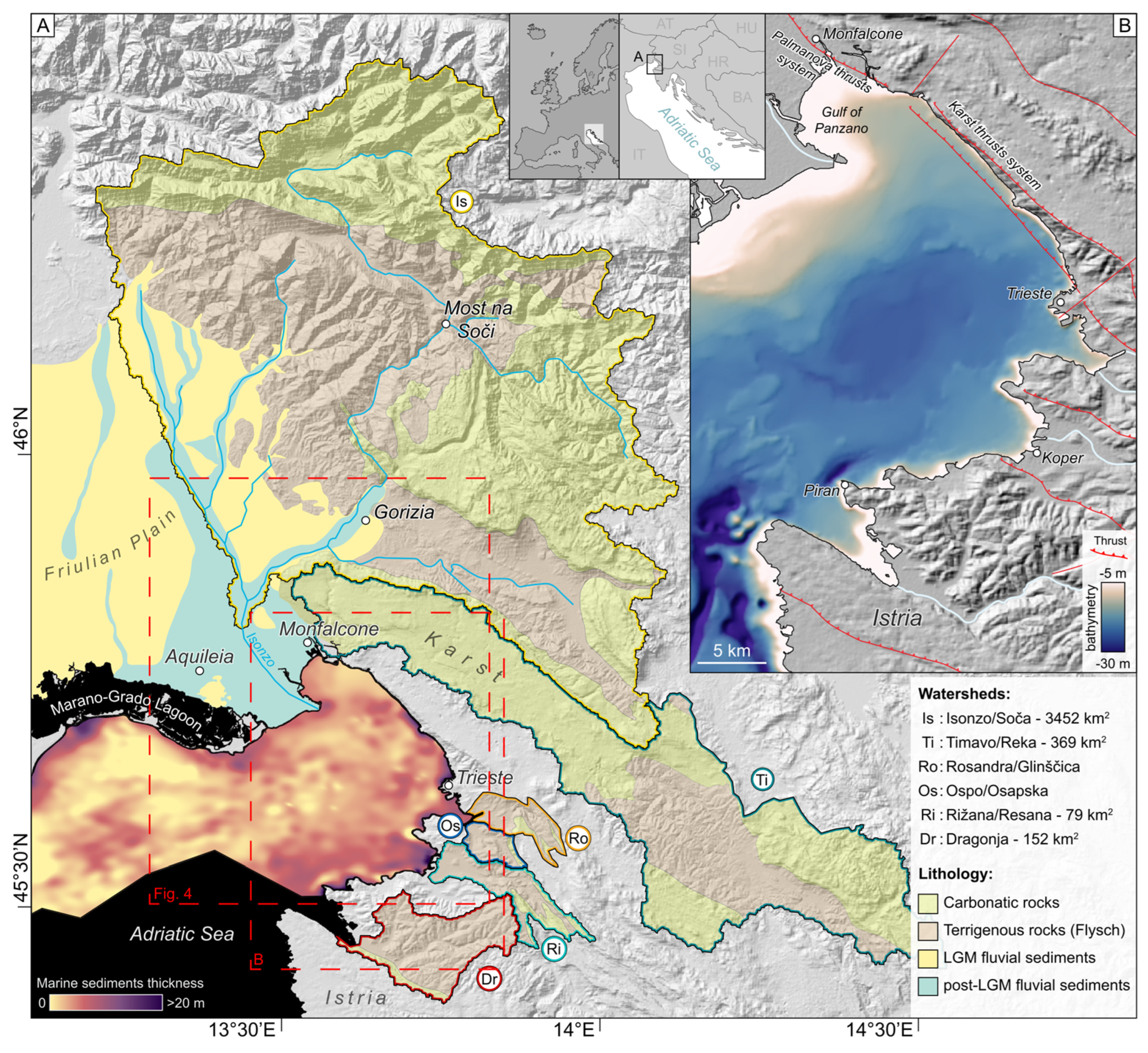
2. Geological and Geomorphological Setting

The Gulf of Trieste is located in the foreland of both the eastern area of the southern Alps and the external Dinaric ranges, with the Palmanova fault system bounding the western cliff of the Karst Plateau [19]. The Karst (Carso and Kras in Italian and Slovenian, respectively) mainly consists of Mesozoic to Paleogene carbonates from Monfalcone to Trieste (Figure 1). Further along the coastline, the Eocene Flysch formation dominates and continues along the coast of northern Istria, down to the Bay of Piran [20]. Flysch is characterized by alternating sandstones and marlstones, and is prone to the production of large quantities of terrigenous materials [21]. The associated landscape is marked with gentle hills with well-developed hydrographic networks, starkly contrasting with the Karst, where surface runoff on carbonates is very limited due to high infiltration rates and predominant dissolution processes [22]. According to recent investigations, current tectonic regional deformation is present but not significant [14].
The Isonzo River is by far the largest fluvial system in the area, with a length of 136 km, a watershed of 3452 km2 and a mean water discharge of 95.5 m3/s [23]. The second largest river is the Timavo, with an approximately 30 m3/s mean water discharge. It originates from the Reka River (drainage basin of 369 km2 extending over Croatia and Slovenia), which sinks in the karstic system and, after ca. 40 km, resurfaces as the Timavo at sea level near Monfalcone [22]. Other notably smaller rivers in the area include Rosandra/Glinščica, Ospo/Osapska reka, Rižana and Dragonja (Figure 1), which are all located between Trieste and Piran.
During the LGM, a glacier covered 650 km2 in the mountain catchment of Isonzo, with the front reaching down to Most na Soči (Figure 1), about 40 km upstream Gorizia [23,24]. This glacier fed the formation of an alluvial megafan extending up to the present-day Gulf of Trieste [11]. Radiocarbon dates indicate that the Isonzo megafan was aggrading until 22–20 ka cal BP, while a recorded period of stasis during the Late Glacial and early Holocene occurred in response to reduced sediment discharge [11,25]. Such starvation took place as a consequence of the accumulation of mass-movement deposits in the upper valley [25], which hampered the downstream routing of sediments and led the Isonzo to entrench its course in the distal plain, as documented near Aquileia [26]. Afterwards, the northernmost portion of the Adriatic basin was submerged by the post-LGM transgression around 9.5–9.0 ka cal BP, and the distal sector of the Isonzo megafan started to be partly onlapped by coastal and lagoon deposits, as documented by the age of the Holocene basal lagoonal deposits recorded in the gulf at a depth between −30 and −25 m mean sea level (MSL) [15,27].

3. Materials and Methods

The reconstructions provided in this work were mainly based on the analysis of shallow sub-bottom seismo-acoustic profiles of Compressed High Intensity Radar Pulse (CHIRP) acquired with a Teledyne Benthos Chirp-III SBP. A modulated bandwidth sweeping between 2–7 kHz was used, allowing a vertical resolution of about 50 cm and penetration up to 25 m below the seabed. The database consisted of 146 profiles covering a total length of 1400 km, acquired onboard the research vessel “Urania” during the oceanographic cruises “VE2004”, “VE2005” and “NAD2012”. During the field operations, the software SwanPro v.2.00 was used, generating XTFs files that were converted to SEGY format. The visualization and processing of seismic data were carried out through the SeisPrho v.2.0 software [28]. DEMs were processed, visualized and analyzed through the QGIS software, and a hillshade visualization was applied to the MBES-derived DEMs in order to highlight the investigated morphologies. Other kinds of image analysis, such as slope and aspect, were also attempted in order to highlight the subtle morphologies.
The morphometry of the Trieste–Piran paleochannel was also characterized through the reconstruction of longitudinal profiles along the channel thalweg, top of the natural levee and adjacent floodplain [14,29].
The seismo-acoustic information was compared with the DEMs derived from the available bathymetric data, previously acquired with MultiBeam Echo Sounder technology (MBES) by Harpha Sea [14] and the Italian Navy [30] over a total surface of 250 km2 (Figure 2). In the zones where MBES surveys were not available, the DEM was derived through interpolating first arrivals of CHIRP soundings, which were then compared to the available map based on single-beam echo sounder profiles [31].
The architecture of the stratigraphy was inferred from previous gravity and piston cores, in which radiocarbon dated samples were used to integrate the data and infer the age of the deposits and landforms [12,15,32,33].
The analysis of the CHIRP profiles allowed us to identify 5 macrofacies summarized in Figure 3. The synthesized sedimentological details are based on cross comparisons of already established seismic facies interpretations in the Gulf of Trieste and northern Adriatic [15,32,34,35].
Figure 3. (A) Interpretation of CHIRP profiles reported in Figure 2. A high-resolution copy of CHIRPs interpretation is available in supplementary material. (B) Map of reconstructed Trieste–Piran paleochannel with indication of traces of available CHIRP profiles (grey straight lines) and identification of sections interpreted on left part of figure (thick red lines); light blue tracts correspond to sectors where MBES data are available, whereas orange lines represent parts where only single-eco bathymetry was carried out (dark grey areas). (C) Legend of seismic facies recognized in study area, with indication of their description and sedimentary interpretation. A high-resolution legend is available in supplementary material. (D) Longitudinal profile along the top elevation of fluvial ridge formed by the paleochannel. Point MDN−1 indicates site of stratigraphic core described by Novak et al. [35].
Geosciences 13 00135 g003

4. Results and Discussion
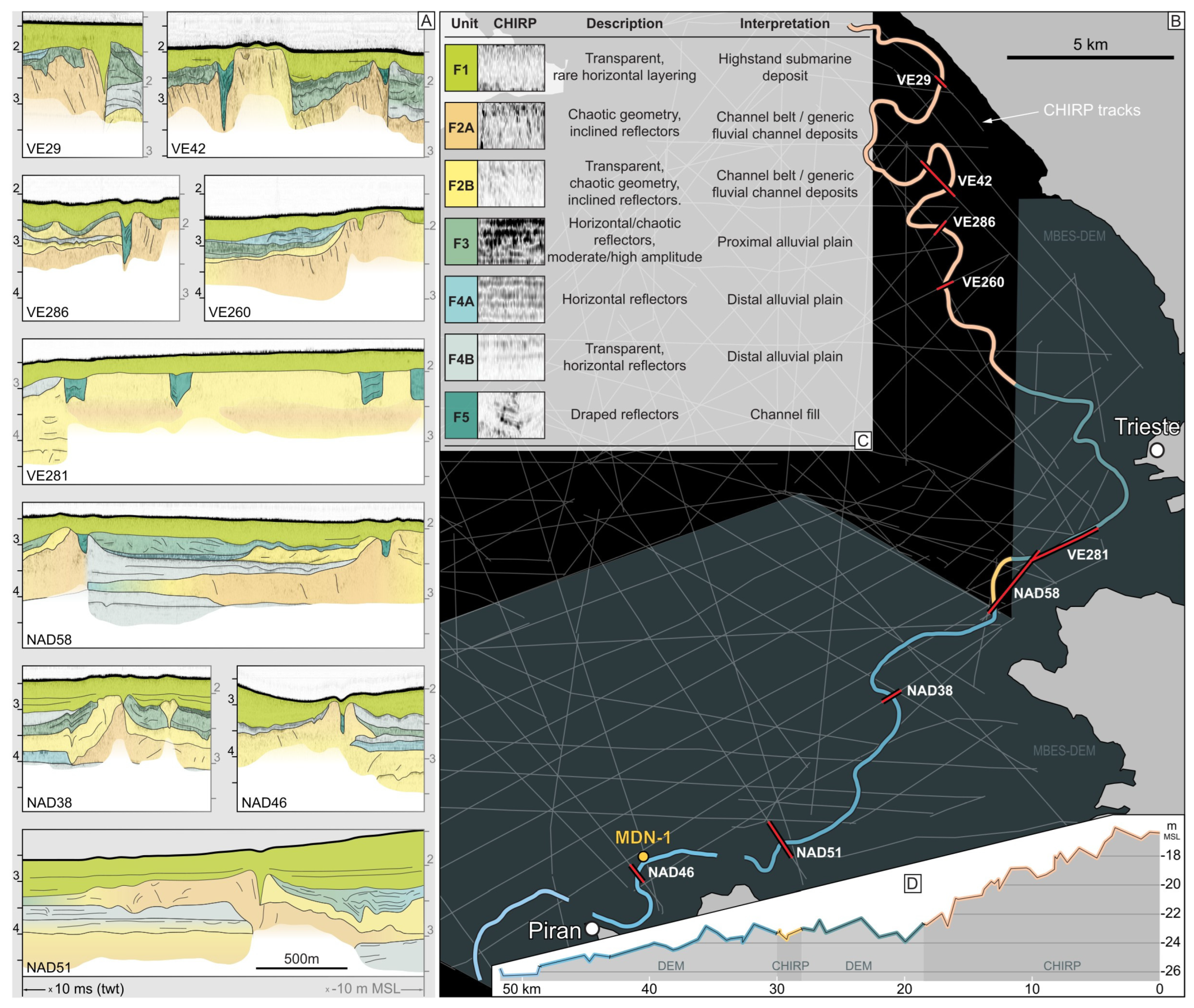
4.1. Seismic Facies

The processing and analysis of the CHIRP profiles identified five main seismic facies which are summarized in the Figure 3A and are described in detail below.
Facies 1 (F1): This facies appears transparent, with very low amplitude and occasional horizontal reflection geometries, while, most of the time, the internal reflection geometry, if observable, is chaotic. For most parts of the gulf, F1 constitutes the top layer of the seafloor. It consists of shallow marine muds that, according to the available geochronological data [12,15], have been deposited since 9.5 ka.
Facies 2 (F2): This facies is often quite transparent, especially at increasing depths, where the acoustic signal appears completely blank. Nevertheless, a chaotic pattern is usually observable in the upper sectors of F2, with shreds of reflectors showing very high amplitude, but almost no lateral continuity. Within the same upper portion, some channel-like shapes can be observed. Based on the amplitude of the seismic response, a further subdivision was applied. Less transparent bodies pertaining to this facies are identified as F2A, while more transparent bodies are identified as F2B. This facies is made up of coarser-grained sediments pertaining to sandy channel belts. The difference between F2A and F2B is probably due to different signal penetration and/or increased signal attenuation in sandier sediment.
Facies 3 (F3): This facies is represented by horizontal-to-chaotic reflection geometries with a moderate-to-high amplitude. It is often laterally connected to F2 and, sometimes, it is difficult to identify a sharp boundary between the two facies, as they can blend at the interface. This facies often contains patches of subhorizontal high-amplitude reflectors, tentatively attributed to remnants of weakly developed soils or peaty deposits. F3 is attributed to a floodplain proximal to the fluvial ridge, where the accumulation of organic deposits and peat was favored due to the presence of waterlogged areas [36].
Facies 4 (F4): This facies displays a more defined horizontal layering if compared to F2, while the overall amplitude remains medium-low and, consequently, appears moderately transparent. F4 is often seamlessly laterally connected to F2. As for F2, Facies 4 is also further subdivided in subfacies F4A and F4B, which show a darker and lighter response, respectively. F4 represents a distal alluvial plain, characterized by the presence of weakly developed soils periodically buried by alluvial sediments, as shown through the presence of horizontal layers with high lateral continuity. The presence of a different degree of transparency (F4A and F4B) might be linked to different stages of development of the soil (increased transparency indicates lesser soil development/organic matter accumulation). The darker subfacies is probably related to the occurrence of paleosurfaces (i.e., buried soils). Alternatively, more/less transparent reflections could indicate an alternation of sediments with more/less similar grain sizes.
Facies 5 (F5): It can be found in localized settings, usually characterized by sharp boundaries dividing it from other facies. While F5 can have either low or high amplitude, an indicative feature are the arrays of draping reflectors, which reproduce the shape of the lower boundary. F5 is usually embedded within F2 deposits and can be attributed to channel fills.

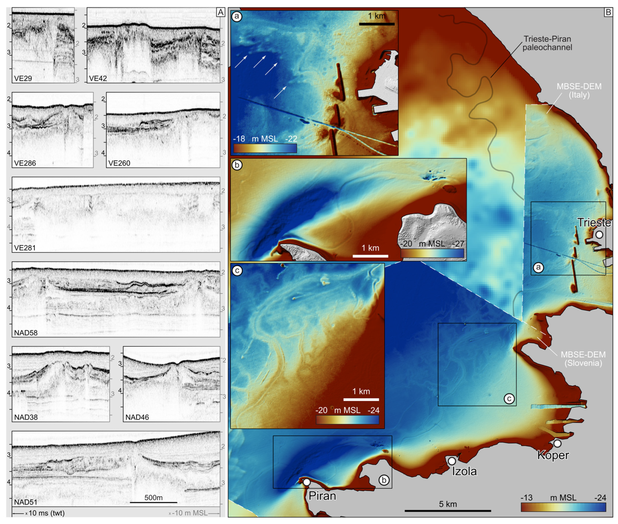
4.2. The Trieste-Piran Paleochannel

Part of the submerged river path described in this work was already recognized and described by Trobec et al. [13]. However, the newly available data allows us to triple its known length, reaching about 50 km, making it the longest drowned fluvial paleochannel thus far recognized in the Mediterranean seabed. The MBES-derived DEMs show well-developed and exceptionally preserved natural levees, indicating the formation of a fluvial ridge aggrading over the pre-existing alluvial plain. The convex nature of this landform and the differential subsidence affecting the diverse facies induced a sensible differential sediment compaction on the overlying marine highstand muddy deposits, making the channel trace clearly visible in the DEMs (Figure 2). The fluvial ridge represented a hydrographic and sedimentary barrier that blocked the streams arriving from the Karst and Istrian catchments, which possibly acted as tributaries of the Isonzo.
The morphological evidence was integrated with CHIRP data, allowing the extension of the recognized river path further upstream, approaching the Gulf of Panzano (Figure 1). The paleo Isonzo River almost perfectly follows the present coastline of the Karst and northern Istria, with an initial NW–SE direction up to Trieste, where it sharply bends and assumes an overall NE–SW direction (Figure 2 and Figure 3). The residual channel has a width of approximately 50 m and a depth ranging between –26 and –31 m MSL in Slovenian waters [13]; similar characteristics are documented in the Italian side, where the MBES surveys are available.
The age of the Trieste–Piran paleochannel can be inferred on the basis of four radiocarbon dated samples collected through the core MDN-1 [34], which is located on the top of the ancient ridge and very close to profile NAD46 (Figure 3). The first 70 cm of stratigraphy are referred to Holocene marine deposits, whereas alluvial sediments are present below and display a significant organic component. Their radiocarbon age progressively increases downwards, ranging from 11.2–11.3 ka at 70 cm of depth below the seabed to 17.4–17.8 ka cal BP at 130 cm [35]. Such a large time span in a short sedimentary interval is interpreted to be the result of the onset of soil forming processes, with accumulation of organic material indicating a prolonged stasis in the natural levee’s accretion. Thus, the age of 17.5 ka cal BP is considered a minimum age (terminus ante quem) for the end of the upbuilding of the Trieste–Piran paleochannel ridge, which can, therefore, be attributed to the last part of LGM. In the Gulf of Trieste, the alluvial unit to which the Trieste–Piran paleoachannel belongs is onlapped by lagoon sediments, dated at their base to about 9.5 ka cal BP. Thus, in the time span between the end of the formation of the studied fluvial ridge and the arrival of the marine transgression, soil forming processes were active and, in some locations, the organic material could accumulate.
A short distance upstream from the city of Trieste, a system of convex landforms was detected along the paleochannel for a tract of over 2 km (Figure 1A). They occur only westward of the fluvial ridge and appear as very narrow ridges elongated in the ENE-WSW direction, seeming to originate from the fluvial ridge itself. Most of them display a lobate front that is partly disposed with an en echelon geometry, and the pattern they form is comparable to the parabolic composed dunes [37,38,39]. As these features are covered with the highstand deposits, they must have formed before the marine transgression on the area (a CHIRP cross section is available in the supplementary material). Thus, we interpreted these morphologies as continental aeolian dunes, fed through the available riverine sediments pertaining the channel and natural levee. The direction of the dune ridges matches the strike of the Bora wind, a north-easterly katabatic wind that presently blows in the northern Adriatic, e.g., the wind speeds in the city of Trieste can reach up to 200 km/h [40]. It is worth noting that the formation of such aeolian landforms would imply scarce vegetation cover in order to allow the deflation of sediments and the movement of the dunes. This environmental setting is compatible with the typical vegetation of the steppe-like environment, which was dominant in the alluvial plains of the northern Adriatic in LGM and until the first part of the Late Glacial period [36,41]. A more extensive system of dunes that formed at the end of the LGM is documented in the megafan of the Isonzo, near Aquileia (Figure 4; [42]).

4.3. Evolution of the Isonzo Alluvial Megafan and Interaction with the Karst and Istria Boundaries

During LGM, in the construction of the easternmost portion of the Friulian Plain, the Isonzo River was conditioned via the conflict with the megafan of the Torre Torrent, which, at that time, was one of the outwashes of the Tagliamento glacier (Figure 4) [11,18]. Torre formed the easternmost sector of its LGM depositional system between 22.5–19.0 ka cal BP [18] and forced the Isonzo to migrate toward south-southeast. It is worth noting that in the present coastal plain of Aquileia, in the sectors where the LGM alluvial plain is still exposed or almost cropped out at surface, the radiocarbon ages span between 21.7 and 20 ka cal BP [26], and are interpreted as related to the final aggrading phase of the megafan of Isonzo in that portion of its distal sector [43]. Moreover, the aeolian sand dunes south of Aquileia (Figure 4) started to form in that phase and eventually continued until the early Late Glacial (unit of S. Marco—Belvedere di Aquileia in Fontana et al. [42]).
Through compiling the reconstructions of the ancient channel belts of Isonzo in the mainland (Figure 4) [26,42,43,44] and new data from the submerged Gulf of Trieste, it is possible to relate the Trieste–Piran paleochannel to the depositional lobe formed during one of the last LGM aggrading phases of the Isonzo. The studied paleo-hydrographic feature corresponds to the last path of river in the easternmost sector of the megafan. In particular, it was one of the paths that originated from an avulsion node near Monfalcone and, as documented in Figure 2 and Figure 3, was characterized by the formation of an evident fluvial ridge. This aggrading trend is very important for comparing the evolution of Isonzo to the depositional phases recognized in the other major alluvial megafans fed through the glaciers of the south-eastern Alps. For instance, in the distal sector of the Tagliamento megafan, the last LGM fluvial aggradation occurred at 22–19.5 ka cal BP, with formation of narrow wandering fluvial ridges along the main channel [18]. Our result is rather comparable to what was documented in the Piave megafan [45], whereas in the Brenta megafan a slightly younger age was found, and the formation of fluvial ridges is recorded up to 17.5 ka cal BP [11,46]. Regardless, after 17.5 ka cal BP, all the major Alpine rivers were incised with respect to the LGM surface and flowed along incised fluvial valleys, even in their distal sector [11,47,48]. Judging from the aggrading trend of the Trieste–Piran paleochannel and the corresponding radiocarbon ages from core MDN-1, we infer that this fluvial path was no longer active after 17.5 ka cal BP.
The river was forced to find its course along the margin of the Karst because of an avulsion sequence that relocated the active channel, following an eastward compensational stacking pattern (Figure 4). The river originally followed this boundary line as the least energetic path (given the negligible fluvial inputs from the Karst), trapping itself between its own megafan and the bedrock cliffs. Downstream from Trieste, the river was forced westward by the rocky cliff of northern Istria, following a path almost perpendicular to the longitudinal direction of the megafan and characterized by an almost null gradient. Thus, even if the Trieste–Piran paleochannel seems to follow the present coastline, there are no relations with the sea level, as it was formed when the coastline was hundreds of kilometers away [16,49]. On the contrary, the existence of the ancient fluvial ridge passively conditioned the development of the coastal environment during the Holocene marine transgression and, most likely, its convex and continuous topography temporarily delayed the coastline to reach the cliffs of the Kars and Istria.
The south-eastward shift of the course of Isonzo along the Trieste–Piran paleochannel caused the elongation of its path, as this corresponds to the longest possible route from the area of Monfalcone to Piran. Indeed, while the positions of input (i.e., the avulsion node) and outlet zones remained almost stable (Figure 4), this constraining setting forced the river to progressively adjust its longitudinal profile to gentler gradients because of the sediments aggrading along the channel path [5,50]. As a matter of fact, the topographic gradient (Figure 3) calculated along the top of the natural levees spans from 0.4‰ (first 20 km in Figure 3) to ca. 0.1‰ (downstream of 20 km). Both values are extremely low, even when compared to the fluvial ridges existing in the present coastal and deltaic plains [29,50]. The gradient of the distal sector of the coeval Isonzo megafan in the mainland, estimated on the basis of still exposed patches of LGM alluvial plain and on available stratigraphic cores, ranges from 1.6‰ to 0.2‰ [26,42].
According to the longitudinal profile, the paleochannel north of Trieste could still be considered a part of the megafan of Isonzo because of its direction and the topographic gradient. After the dramatic change in direction towards WSW, the river flowed along a path perpendicular to the megafan. Therefore, the tract downstream of Trieste could be considered as a general alluvial plain.
The dramatic contrast of gradient between the analyzed paths of Isonzo and the top of its megafan will inevitably induce a stark variation in river transport capacity [5]. This suggests that the recognized autogenic processes and compensating effects might have resulted in deep modifications to the fluvial system (e.g., grainsize of the bedload, sinuosity of the channel and fluvial style), rather than just in a geometric adjustment of the longitudinal profile [10].
Most notably, the reduced competence induced via the reduced gradient translates into the upbuilding of the alluvial plain due to the higher quantity of sediment ruled out through the transport processes. In theory, sediments will be supplied into this area and result in aggradation in certain portions of the alluvial plain. Anyhow, the Trieste–Piran direction was deactivated because of an avulsion that shifted the Isonzo much further westward, close to the area of Grado, transforming the channel in a relict landform with all its original morphological features.

5. Conclusions

The extensive network of CHIRP-sonar profiles and multibeam surveys in the Gulf of Trieste allowed us to identify a 50 km-long meandering fluvial ridge characterized by a very-low-to-null gradient, which is attributed to a course of the Isonzo River formed at the end of the LGM. This feature is the longest and best preserved submerged paleochannel recognized so far in the Mediterranean seafloor.
The Isonzo River occupied the suture between its own megafan and the rocky cliffs of the Karst Plateau, which is characterized by an almost null sediment production. The peculiar path followed by the paleochannel, which replicates the modern coastline, is the result of the interplay between the dynamics of the alluvial system of Isonzo and the constrain represented through the bedrock boundary. The shifting was ruled both through a compensational stacking behavior, induced via the formation of different lobes of the megafan, and the competition with the Torre River and its megafan, pushing from the north-western side. These combined factors induced the stretching of the river course, decreasing the longitudinal gradient and setting new conditions of transport and style conditions for the system. The downstream boundary condition set due to the presence of the Karst and Istrian cliffs induced an upstream autogenic response, which modified the river’s style, transport and evolutive tendencies. This study demonstrates the importance of considering paleo-geographic conditions when attempting to reconstruct the sedimentary architecture of an alluvial plain. The constraining boundary conditions can induce a variety of autogenic processes that can strongly affect the dynamics of the sediment routings. Our results also recognize the presence of widespread aeolian processes on the former Adriatic Plain during the LGM.

Supplementary Materials

The following supporting information can be downloaded at: https://www.mdpi.com/article/10.3390/geosciences13050135/s1, Figure S1: Legend of the seismic facies recognized in the study area; Figure S2: Selected CHIRP profiles crossing the Trieste-Piran paleochannel; Figure S3: Interpretation of selected CHIRP profiles crossing the Trieste-Piran paleochannel; Figure S4: Detailed DEM of the area of the harbor of Trieste; Figure S5: Tract of the interpreted CHIRP profile VE043; Figure S6: Stratigraphic log of the core MDN–1.

Author Contributions

Conceptualization, L.R. and A.F.; methodology, L.R., A.F., A.C. and A.N.; data acquisition A.C., A.F., A.N. and S.P.; data processing and analysis, L.R., A.F., A.C. and A.N.; writing—original draft preparation, L.R. and A.F.; funding acquisition, A.F. and A.C. All authors have read and agreed to the published version of the manuscript.

Funding

A.F. and L.R. were funded by University of Padova within the project “SEA LEAPS: SEA-LEvel rApid PulseS during the Holocene marine transgression” (responsible A.F.); part of the data processing stage was carried out by A.C. in the framework of the Flagship Project RITMARE–The Italian Research for the Sea, coordinated by the Italian National Research Council and funded by the Italian Ministry of Education, University and Research within the National Research Program for 2011–2013; this paper is publication n. 2045 of ISMAR CNR. A.N. and S.P. were funded by the Slovenian Research Agency within project J1-1712 and program group P1-0011”.

Data Availability Statement

All data and information are available in the main text or supplementary material.

Acknowledgments

The authors thank the team of RITMARE Project. The comments and notes suggested by the anonymous reviewers helped in improving the paper.

Conflicts of Interest

The authors declare no conflict of interest.

References

  1. Miall, A. The Geology of Fluvial Deposits: Sedimentary Facies, Basin Analysis, and Petroleum Geology; Springer: Berlin/Heidelberg, Germany, 2013; ISBN 978-3-662-03237-4. [Google Scholar]
  2. Blom, A.; Viparelli, E.; Chavarrías, V. The Graded Alluvial River: Profile Concavity and Downstream Fining. Geophys. Res. Lett. 2016, 43, 6285–6293. [Google Scholar] [CrossRef]
  3. Gibling, M.R.; Tandon, S.K.; Sinha, R.; Jain, M. Discontinuity-Bounded Alluvial Sequences of the Southern Gangetic Plains, India: Aggradation and Degradation in Response to Monsoonal Strength. J. Sediment. Res. 2005, 75, 369–385. [Google Scholar] [CrossRef]
  4. Weissmann, G.S.; Hartley, A.J.; Nichols, G.J.; Scuderi, L.A.; Olson, M.; Buehler, H.; Banteah, R. Fluvial Form in Modern Continental Sedimentary Basins: Distributive Fluvial Systems. Geology 2010, 38, 39–42. [Google Scholar] [CrossRef]
  5. Reitz, M.D.; Jerolmack, D.J. Experimental Alluvial Fan Evolution: Channel Dynamics, Slope Controls, and Shoreline Growth. J. Geophys. Res. 2012, 117, 2011JF002261. [Google Scholar] [CrossRef]
  6. Latrubesse, E.M. Large Rivers, Megafans and Other Quaternary Avulsive Fluvial Systems: A Potential “Who’s Who” in the Geological Record. Earth-Sci. Rev. 2015, 146, 1–30. [Google Scholar] [CrossRef]
  7. Schumm, S.A.; Mosley, M.P.; Weaver, W.E. Experimental Fluvial Geomorphology; Wiley: New York, NY, USA, 1967. [Google Scholar]
  8. Bridge, J.S. Rivers and Floodplains: Forms, Processes, and Sedimentary Record; Blackwell Pub: Oxford, UK; Malden, MA, USA, 2003; ISBN 978-0-632-06489-2. [Google Scholar]
  9. Bowman, D. Principles of Alluvial Fan Morphology; Springer: Dordrecht, The Netherlands, 2019; ISBN 978-94-024-1556-8. [Google Scholar]
  10. Ventra, D.; Nichols, G.J. Autogenic Dynamics of Alluvial Fans in Endorheic Basins: Outcrop Examples and Stratigraphic Significance. Sedimentology 2014, 61, 767–791. [Google Scholar] [CrossRef]
  11. Fontana, A.; Mozzi, P.; Marchetti, M. Alluvial Fans and Megafans along the Southern Side of the Alps. Sediment. Geol. 2014, 301, 150–171. [Google Scholar] [CrossRef]
  12. Covelli, S.; Fontolan, G.; Faganeli, J.; Ogrinc, N. Anthropogenic Markers in the Holocene Stratigraphic Sequence of the Gulf of Trieste (Northern Adriatic Sea). Mar. Geol. 2006, 230, 29–51. [Google Scholar] [CrossRef]
  13. Trobec, A.; Busetti, M.; Zgur, F.; Baradello, L.; Babich, A.; Cova, A.; Gordini, E.; Romeo, R.; Tomini, I.; Poglajen, S.; et al. Thickness of Marine Holocene Sediment in the Gulf of Trieste (Northern Adriatic Sea). Earth Syst. Sci. Data 2018, 10, 1077–1092. [Google Scholar] [CrossRef]
  14. Trobec, A.; Šmuc, A.; Poglajen, S.; Vrabec, M. Submerged and Buried Pleistocene River Channels in the Gulf of Trieste (Northern Adriatic Sea): Geomorphic, Stratigraphic and Tectonic Inferences. Geomorphology 2017, 286, 110–120. [Google Scholar] [CrossRef]
  15. Trincardi, F.; Argnani, A.; Correggiari, A. (Eds.) Note Illustrative della Carta Geologica d’Italia alla Scala 1:250.000—Foglio NL33–7 “Venezia”; ISPRA—Servizio Geologico d’Italia: Roma, Italy, 2011; p. 156.
  16. Amorosi, A.; Bracone, V.; Campo, B.; D’Amico, C.; Rossi, V.; Rosskopf, C.M. A Late Quaternary Multiple Paleovalley System from the Adriatic Coastal Plain (Biferno River, Southern Italy). Geomorphology 2016, 254, 146–159. [Google Scholar] [CrossRef]
  17. Buser, S.; Komac, M. Geological Map of Slovenia 1: 250,000; Geological Survey of Slovenia: Ljubljana, Slovenia, 2009. [Google Scholar]
  18. Fontana, A.; Monegato, G.; Devoto, S.; Zavagno, E.; Burla, I.; Cucchi, F. Geomorphological evolution of an Alpine fluvioglacial system at the LGM decay: The Cormor type megafan (NE Italy). Geomorphology 2014, 204, 136–153. [Google Scholar] [CrossRef]
  19. Carulli, G.B. Structural Model of the Trieste Gulf: A Proposal. J. Geodyn. 2011, 51, 156–165. [Google Scholar] [CrossRef]
  20. Busetti, M.; Volpi, V.; Barison, E.; Giustiniani, M.; Marchi, M.; Ramella, R.; Zanolla, C. Meso-Cenozoic seismic stratigraphy and the tectonic setting of the Gulf of Trieste (northern Adriatic). GeoActa SP 2010, 3, 1–14. [Google Scholar]
  21. Keesstra, S.D.; van Huissteden, J.; Vandenberghe, J.; Van Dam, O.; de Gier, J.; Pleizier, I.D. Evolution of the Morphology of the River Dragonja (SW Slovenia) Due to Land-Use Changes. Geomorphology 2005, 69, 191–207. [Google Scholar] [CrossRef]
  22. Cucchi, F.; Finocchiaro, F. Karst Landforms in Friuli Venezia Giulia: From Alpine to Coastal Karst. In Landscapes and Landforms of Italy; Soldati, M., Marchetti, M., Eds.; World Geomorphological Landscapes; Springer International Publishing: Cham, Switzerland, 2017; pp. 147–156. ISBN 978-3-319-26192-8. [Google Scholar]
  23. Siché, I.; Arnaud-Fassetta, G. Anthropogenic Activities since the End of the Little Ice Age: A Critical Factor Driving Fluvial Changes on the Isonzo River (Italy, Slovenia). Mediterranée 2014, 122, 183–199. [Google Scholar] [CrossRef]
  24. Jamšek Rupnik, P.; Žebre, M.; Monegato, G. Late Quaternary Evolution of the Sedimentary Environment in Modrejce near Most Na Soči (Soča Valley, Julian Alps). Geologija 2020, 63, 295–309. [Google Scholar] [CrossRef]
  25. Bavec, M.; Tulaczyk, S.M.; Mahan, S.A.; Stock, G.M. Late Quaternary Glaciation of the Upper Soča River Region (Southern Julian Alps, NW Slovenia). Sediment. Geol. 2004, 165, 265–283. [Google Scholar] [CrossRef]
  26. Arnaud-Fassetta, G.; Carré, M.-B.; Marocco, R.; Maselli Scotti, F.; Pugliese, N.; Zaccaria, C.; Bandelli, A.; Bresson, V.; Manzoni, G.; Montenegro, M.E.; et al. The site of Aquileia (northeastern Italy): Example of fluvial geoarchaeology in a Mediterranean deltaic plain. Géomorphologie Relief Process. Environ. 2003, 9, 227–245. [Google Scholar] [CrossRef]
  27. Vacchi, M.; Marriner, N.; Morhange, C.; Spada, G.; Fontana, A.; Rovere, A. Multiproxy Assessment of Holocene Relative Sea-Level Changes in the Western Mediterranean: Sea-Level Variability and Improvements in the Definition of the Isostatic Signal. Earth-Sci. Rev. 2016, 155, 172–197. [Google Scholar] [CrossRef]
  28. Gasperini, L.; Stanghellini, G. SeisPrho: An Interactive Computer Program for Processing and Interpretation of High-Resolution Seismic Reflection Profiles. Comput. Geosci. 2009, 35, 1497–1507. [Google Scholar] [CrossRef]
  29. Berendsen, H.J.A.; Stouthamer, E.; Berendsen, H.J.A. Palaeogeographic Development of the Rhine-Meuse Delta, The Netherlands; Koninklijke Van Gorcum: Assen, The Netherlands, 2001; ISBN 978-90-232-3695-5. [Google Scholar]
  30. Foglini, F.; Bosman, A.; Correggiari, A.; Remia, A.; Madricardo, F.; Mariacristina, P.; Fontolan, G.; Biscotti, E.; Ferrero, S.; Pizzeghello, N.; et al. Carta Batimorfologica dell’Adriatico Settentrionale; Zenodo: Geneva, Switzerland, 2020. [Google Scholar] [CrossRef]
  31. Trincardi, F.; Campiani, E.; Correggiari, A.; Foglini, F.; Maselli, V.; Remia, A. Bathymetry of the Adriatic Sea: The Legacy of the Last Eustatic Cycle and the Impact of Modern Sediment Dispersal. J. Maps 2014, 10, 151–158. [Google Scholar] [CrossRef]
  32. Masoli, C.A.; Petronio, L.; Gordini, E.; Deponte, M.; Bohm, G.; Cotterle, D.; Romeo, R.; Barbagallo, A.; Belletti, R.; Maffione, S.; et al. Near-shore geophysical and geotechnical investigations in support of the Trieste Marine Terminal extension. Near Surf. Geophys. 2020, 18, 73–89. [Google Scholar] [CrossRef]
  33. Correggiari, A.M.; Roveri, M.; Trincardi, F. Late Pleistocene and Holocene Evolution of the North Adriatic Sea. Il Quat. Ital. J. Quat. Sci. 1996, 9, 697–704. [Google Scholar]
  34. Ronchi, L.; Fontana, A.; Correggiari, A.; Remia, A. Anatomy of a Transgressive Tidal Inlet Reconstructed through High-Resolution Seismic Profiling. Geomorphology 2019, 343, 65–80. [Google Scholar] [CrossRef]
  35. Novak, A.; Šmuc, A.; Poglajen, S.; Vrabec, M. Linking the High-Resolution Acoustic and Sedimentary Facies of a Transgressed Late Quaternary Alluvial Plain (Gulf of Trieste, Northern Adriatic). Mar. Geol. 2020, 419, 106061. [Google Scholar] [CrossRef]
  36. Miola, A.; Bondesan, A.; Corain, L.; Favaretto, S.; Mozzi, P.; Piovan, S.; Sostizzo, I. Wetlands in the Venetian Po Plain (Northeastern Italy) during the Last Glacial Maximum: Interplay between Vegetation, Hydrology and Sedimentary Environment. Rev. Palaeobot. Palynol. 2006, 141, 53–81. [Google Scholar] [CrossRef]
  37. Filion, L.; Morriset, P. Eolian landforms along the eastern coast of Hudson Bay, Northern Québec. Collect. Nord. 1993, 47, 73–94. [Google Scholar]
  38. Pye, K.; Lancaster, N. (Eds.) Aeolian Sediment, Ancient and Modern; John Wiley & Sons: New York, NY, USA, 1993; p. 169. [Google Scholar]
  39. Durán, O.; Herrmann, H.J. Vegetation against dune mobility. Phys. Rev. Lett. 2006, 97, 4. [Google Scholar] [CrossRef]
  40. Belusić, D.; Bencetić Klaić, Z. Mesoscale Dynamics, Structure and Predictability of a Severe Adriatic Bora Case. Meteorol. Z. 2006, 15, 157–168. [Google Scholar] [CrossRef]
  41. Vescovi, E.; Ravazzi, C.; Arpenti, E.; Finsinger, W.; Pini, R.; Valsecchi, V.; Wick, L.; Ammann, B.; Tinner, W. Interactions between Climate and Vegetation during the Lateglacial Period as Recorded by Lake and Mire Sediment Archives in Northern Italy and Southern Switzerland. Quat. Sci. Rev. 2007, 26, 1650–1669. [Google Scholar] [CrossRef]
  42. Fontana, A.; Monegato, G.; Rossato, S.; Poli, E.M.; Furlani, S.; Stefani, C. (Eds.) Carta delle Unità Geologiche della Pianura del Friuli Venezia Giulia alla Scala 1:150,000; Regione Autonoma Friuli Venezia Giulia—Servizio Geologico: Trieste, Italy, 2019; p. 80. [Google Scholar]
  43. Marocco, R. Prima ricostruzione paleo-idrografica del territorio della Bassa pianura Friulano-Isontina e della Laguna di Grado nell’Olocene. Gortania—Atti Museo Friulano Storia Naturale. Gortania Geol. Paleontol. Paletnologia 2009, 31, 69–86. [Google Scholar]
  44. Marocco, R.; Melis, R. Stratigrafia e paleogeografia del “Lacus Timavi” (Friuli Venezia Giulia). Il Quat. Ital. J. Quat. Sci. 2009, 22, 157–170. [Google Scholar]
  45. Carton, A.; Bondesan, A.; Fontana, A.; Meneghel, M.; Miola, A.; Mozzi, P.; Primon, S.; Surian, N. Geomorphological evolution and sediment transfer in the Piave River watershed (north-eastern Italy) since the LGM. Géomorphologié Relief Process. Environ. 2009, 3, 37–58. [Google Scholar] [CrossRef]
  46. Rossato, S.; Mozzi, P. Inferring LGM sedimentary and climatic changes in the southern Eastern Alps foreland through the analysis of a 14C ages database (Brenta megafan, Italy). Quat. Sci. Rev. 2016, 148, 115–127. [Google Scholar] [CrossRef]
  47. Mozzi, P.; Ferrarese, F.; Fontana, A. Integrating digital elevation models and stratigraphic data for the reconstruction of the post-LGM unconformity in the Brenta alluvial megafan (North-Eastern Italy). Alp. Mediterr. Quat. 2013, 26, 41–54. [Google Scholar]
  48. Ronchi, L.; Fontana, A.; Cohen, K.M.; Stouthamer, E. Late Quaternary landscape evolution of the buried incised valley of Concordia Sagittaria (Tagliamento River, NE Italy): A reconstruction of incision and transgression. Geomorphology 2021, 373, 107509. [Google Scholar] [CrossRef]
  49. Peresani, M.; Monegato, G.; Ravazzi, C.; Bertola, S.; Margaritora, D.; Breda, M.; Fontana, A.; Fontana, F.; Janković, I.; Karavanić, I.; et al. Hunter-gatherers across the great Adriatic-Po region during the Last Glacial Maximum: Environmental and cultural dynamics. Quat. Int. 2021, 581–582, 28–163. [Google Scholar] [CrossRef]
  50. Cohen, S.; Wan, T.; Islam, M.T.; Syvitski, J.P.M. Global River Slope: A New Geospatial Dataset and Global-Scale Analysis. J. Hydrol. 2018, 563, 1057–1067. [Google Scholar] [CrossRef]
Figure 2. (A) Selected CHIRP profiles crossing the Trieste–Piran paleochannel; traces of profiles and their interpretation are reported in Figure 3. A high-resolution copy of CHIRPs is available in supplementary material. (B) DEM of Gulf of Trieste. Insets (ac) represent details of bathymetric models elaborated from multibeam data [14,30]. DEMs are derived through MBES data for whole Slovenian waters and for bay of Trieste, whereas in rest of study zone, DEM is obtained from the first arrival of CHIRP soundings and single eco-sounder surveys. Thin black line indicates the path of Trieste–Piran paleochannel where it is not clearly evident in DEM and was inferred through the analyses of CHIRP profiles. In (a), white arrows indicate occurrence of dune-like landforms.
Geosciences 13 00135 g002
Figure 4. Sketch of main channel belts of Torre and Isonzo megafans in mainland and Gulf of Trieste since LGM; Holocene paths in mainland are derived from [43,44].
Geosciences 13 00135 g004
Disclaimer/Publisher’s Note: The statements, opinions and data contained in all publications are solely those of the individual author(s) and contributor(s) and not of MDPI and/or the editor(s). MDPI and/or the editor(s) disclaim responsibility for any injury to people or property resulting from any ideas, methods, instructions or products referred to in the content.

