1. Introduction
In the last few decades and under the UNESCO (United Nations Educational Scientific and Cultural Organization) initiative, there has been an increasing attempt to establish environmental education and its framework in various ways. More precisely, a meeting in Belgrade (Serbia) in 1976, under the auspices of UNESCO, formalized a set of documents known as Charter of Statutes of Belgrade [
1], explicitly mentions the need for a significant change in human attitudes by taking more effective action for the global environmental issue through universal effort at school units. As a result of this effort, a strategy has been established that will allow some organizations and individuals to present more systematic content on environmental challenges and how to address them. In this way, a more harmonious balance between environment and human activity could be reached. This has resulted in several environmental programs in schools, with the goal of rationalizing future citizens to assist them in adopting a more positive attitude toward the needs of our planet and our society, after having received appropriate and necessary knowledge of such matters in advance.
It is worth mentioning that UNESCO never gave up on the idea and initiative of the environmental education; in fact, in 1977 [
2], in the context of the International Conference in Tbilisi (Georgia), the participants agreed that environmental education should be treated as a distinct scientific field of paramount importance that should be integrated into educational programs rather than being treated as an afterthought.
Along with environmental education, an international effort was launched to establish and protect the geological heritage. In 1972, the Convention on the Protection of the World Cultural and Natural Heritage took place in Paris (France), and some years later, in 1991, the International Declaration on the Rights of the Memory of the Earth took place in Digne (France) [
3]. Through these conferences and their declarations, a European initiative for the protection of geoheritage and geoconservation was launched, with the goal of protecting exceptional geological areas that reflect the evolution of biotic and abiotic factors. In 2000, the European Geoparks Network (EGN) was founded to promote a more systematic and collective process of development and, of course, to ensure geodiversity [
4]. Following this, in 2004, the Global Geoparks Network was established, which, along with the EGN, aims to promote the concept of geological heritage in the scientific community and the public, as well as to promote sustainable development in areas that host the geoparks [
5].
Despite these initiatives to promote and protect the geological heritage, environmental education does not deepen directly into issues related to geoethics, geodiversity, and geoheritage. There is a reasonable need to promote geoeducation, which will deal exclusively with the above concepts and will be the primary tool for the first transmission of knowledge and highlighting the importance of places of intense geological interest, which, in turn, will offer the opportunity of geotourism services [
6]. Specifically, geotourism encourages various forms of geoeducation in order to organize geosites to be open for the public and offering educational and recreational activities [
7,
8].
Finally, the need for a more rational assessment of the geoenvironmental status of our planet, as well as the need for more effective management of issues connected to geoenvironmental conservation, led to the development of a new field of geosciences: Geoethics. The first function of geoethics is to improve the social profile and role of geoscience. Moreover, it contributes to forwarding the sustainable use of natural sources with harmonious operation between human activity and environment. Consequently, this field can accelerate strategies and methods that will respect geoheritage and its prospective [
9].
The purpose of this review is, first, to highlight the concepts of geological heritage and geoconservation and the importance of geoeducation for the proper promotion and utilization of geological heritage for the benefit of the common good. The terms “geotourism” and “geoethics”, as well as their interconnectedness, emerge from this review. Particular emphasis is placed on the situation prevailing in Greece regarding the protection and use of geological heritage, geoeducation, and most importantly, the current legal framework.
2. Literature Overview
2.1. Geoheritage and Geoconservation
“Geoheritage” is a new term that assumes complete perception of Man for nature and the environment [
10]. As stated by Carcavilla et al. [
11] “Geological-geomorphological heritage is the collection of geotopes, deposits, forms, and processes that comprise the geological history of each region, and the concept of preserving geological-geomorphological heritage is a cultural concept”.
Geoheritage aims to highlight the diversity of our planet to illustrate the importance of the biotic and abiotic factors, which document the historical evolution of the Earth [
12]. Furthermore, geoheritage focuses on the important geological elements, such as rocks, minerals, and fossils that interpret the effects of past and present actions, which have shaped landforms and other geomorphological structures [
13]. The value of geological heritage is further underlined in report from UNESCO [
14], according to which geological heritage is characterized as the whole of the most interesting geological sites (geotopes, geoparks, and geological natural monuments) that deserve to be preserved for scientific, didactic, historical, aesthetic, and cultural reasons. There is also a reference in the European Manifesto on Earth Heritage and Geodiversity [
15] that argues that the heritage of Earth interconnects the Earth, its people, and their culture; that is, it forms the cornerstone and foundation of our society.
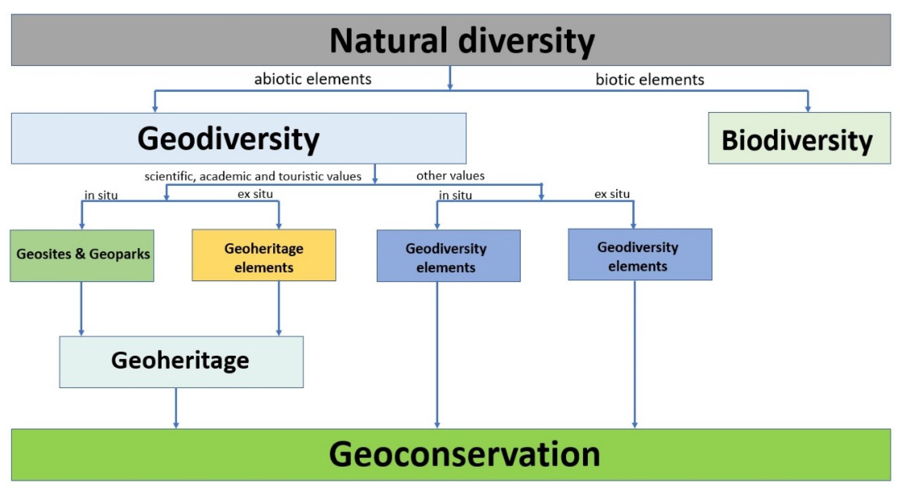
The link between geological heritage and geodiversity, on the other hand, is quite complicated and encompasses all the elements that contribute to the creation and development of the Earth [
16] (
Figure 1). Geodiversity is a crucial component of the Earth system and is described as the variability of abiotic nature or the abiotic diversity of the surface of the Earth. Geodiversity, along with biodiversity, constitutes the natural diversity of our planet.
Geoconservation is a relatively new scientific field that has emerged in recent decades due to the growing importance of conservation and sustainable use of environmental resources [
17].
The concept of “geoconservation” can be defined as an activity or group of actions that contribute to the conservation, rational management, and protection of geological structures that present geodiversity and hence have scientific and educational value [
18]. The term “geoconservation” first appeared in the 1990s e.g., [
18]: more specifically, Semeniuk [
19] and Semeniuk and Semeniuk [
20] reported that geoconservation is concerned with the conservation and preservation of the features of Earth for educational, scientific, and hereditary purposes. Etymologically, this term combines conservation specifically with geological features and parameters. The goal of geoconservation is to identify, protect, and manage valuable parts of geodiversity. According to the international literature, geoconservation is a broad field that deals with concerns such as environmental management, geological hazards (geohazards), and sustainable development [
21]. Thus, it becomes clear that geoconservation is initially part of geodiversity along with biodiversity, which together constitute the two major environmental components. There is also the preservation of the geoheritage that highlights the geological history of the Earth.
Figure 1.
Conceptual framework of geodiversity, geological heritage, and geoconservation. Modified from [
22].
Figure 1.
Conceptual framework of geodiversity, geological heritage, and geoconservation. Modified from [
22].
The first steps for the implementation and dissemination of geoheritage and geoconservation are drawn from historical data: a typical example took place at the beginning of the 19th century, when over-exploitation in the quarry in the Salisbury area of Edinburgh, Scotland, had a huge negative impact on the geomorphology of the adjacent city, resulting in a decision in 1819 with legal coverage to protect the characteristic rock and to avoid further deterioration of the area [
23]. Later, Germany established, in 1836, the first geological natural monument in the world in the Siebengebirge area, located southeast of the city of Bonn: there were several quarries in this area where the mineral wealth exploitation over a long period of time ended unpleasantly. The initiative was taken by the then Prussian government to protect the region. In 1872 in USA, the Yellowstone National Park was founded due to its scenic beauty and the many geological formations and phenomena observed in it [
24]. As early as the 1870s in Switzerland, Fritz Muhlberg started a campaign mainly for the protection of erratic stones (massive irregular masses) that were systematically exploited [
25]. In fact, at the same time, a committee is set up in Scotland to propose measures for the protection and preservation of these stones [
26]. Finally, it is worth mentioning that, according to the data at hand, Tanzania is considered the leader in the battle for land conservation [
18], where an intense effort is in place to protect geological areas such as Ngorongoro lengai in Tanzania, where an active volcano is also located, and to protect fauna and wildlife.
2.2. The Need for More Systematic Use of Geoeducation and Its Awareness
The traditional educational system cannot highlight the importance and components of geological heritage. As a result, it is vital to make geoeducation more widely available, as well as to integrate it into special curricula programs at various school levels. In this way, there will be a major opportunity for future citizens to be informed about issues that raise geological and cultural interest. It is worth noting here that the European and Global Geopark networks allow the full development of geoeducation, as there is an on-site opportunity for both the public and the scientific community to be informed through educational and cultural activities [
27,
28]. In addition, the diverse geotopes of geoparks, geosites, and geotrails are valuable tools that may be used by professional geoguides to educate visitors about their importance and impact on the ecosystem.
According to the planning and the agenda of UNESCO [
29], education and sustainable development are key objectives for the World Geoparks. Rational information and geoeducation regarding sustainable development can deposit a wide range of uses through geoparks, where the geological and cultural heritage is accentuated. As a result, the immediate goal of a geopark is to assist students who visit them in gaining a better understanding of sustainability and its positive prospects, with the goal of achieving better life conditions for future generations.
Thus, it becomes even clearer that geoeducation constitutes the main tool for transmitting knowledge and, at the same time, emphasizing the importance of geoheritage and geoconservation. Specifically, geoeducation can address the following points: knowledge and awareness of the value of geological monuments; direct experience and understanding of the historical evolution of the planet, and thus the importance of geoheritage reflected in the rocks; and the establishment of natural history museums for the promotion and more systematic identification of areas of intense geological interest and awareness and perception of the geoethical dimension of important geological sites. Furthermore, the aforementioned points, along with the presence of geotopes and geoparks, are appropriate elements for in situ geoeducation both locally and regionally or even internationally. The harmonious coexistence of people with their environment presupposes a thorough understanding of the fundamental of geological processes active in the formation of the planet. This knowledge ensures an attitude for the protection of the environment and strengthens the view of citizens on issues of protection of natural and geological monuments.
It should also be mentioned that the natural history museums that are part of a geopark can widely contribute, with educational activities, special learning programs, outdoor exercises, seminars for teachers and students, organization of conferences and lectures, elaboration and support of research or school programs, cooperation with environmental education centers, creation of interactive educational material, cooperation with global environmental management institutes, and finally, cooperation with universities. In addition, the dissemination of geoeducation can be done in various ways, such as with a series of guided geotrails, knowledge transfer through educational activities organized by qualified teaching staff of each geopark and addressed to schools, and departments of universities and research institutes. In this way, geoeducation can be promoted.
Following that, the transmission and preservation of geoheritage and related concepts can be combined with strategic applications and means that could contribute to the development of the local community.
2.3. The Positive Impact of Geotourism
Geotourism is a relatively new and ever-changing phenomenon. As a result, it is natural that different approaches exist, owing primarily to the geological peculiarities of the areas involved. This means, among other things, that no universally accepted definition of geotourism exists. This could be considered a type of alternative tourism that combines tourism and geology. On the one hand, tourism is a recreational activity based on subjective and aesthetic criteria. Geology, on the other hand, is a science that employs objective criteria. As a result, tourism and geology are two very different disciplines that can coexist and form geotourism, a new emerging type of “environmentally innovative” tourism.
Geotourism is a relatively new form of alternative tourism with significant European and global development potential. It first appeared at the beginning of the 21st century, especially with the appearance and institutionalization of geoparks, which are areas with important geological heritage and rich natural and cultural environments, which, through nature protection and education, contribute to the development of responsible tourism, strengthening the local economy and sustainable development [
30].
To date, many interpretations of the concept of geotourism have been provided. Thus, geotourism is a subset of ecotourism that occurs in areas with significant geological monuments [
31,
32] and “prioritizes the interactive experience through contact with the geoenvironment and the cultural elements that form the unique identity of each place”. In other words, it focuses on the characteristics of the environment of an area with emphasis on landscape and geoenvironment, which includes not only geological elements but also all other elements of cultural and natural heritage, which are closely linked and interdependent with the respective geological environment of a place [
33,
34].
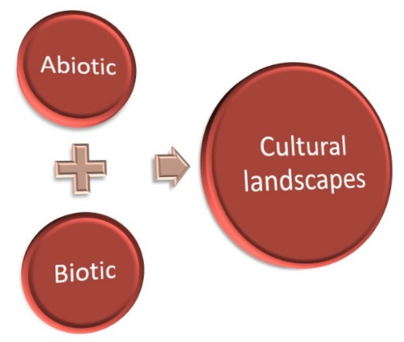
A key component for the development of geotourism is the understanding of the identity or character of an area. To achieve this, geotourism is based on the idea that the environment consists of abiotic, biotic, and cultural elements (
Figure 2). This “ABC” approach of Dowling [
35] includes the abiotic elements of geology and climate, the biotic elements of animals (fauna) and plants (flora), and the cultural or human components of the past and present. Geotourism argues that, to fully understand and appreciate the environment, we must first know the abiotic elements of geology and climate, as these determine the biotic elements of the animals and plants that live there.
Consequently, the combination of the abiotic and biotic components of the environment determines the cultural landscape and how people lived in the area in the past, as well as how they live there today.
Furthermore, modern geotourism is distinguished by three major components known as the 3Gs: geointerpretation, geodiversity, and geohistory [
8].
For the development of geotourism, there must be systematic steps towards the geoconservation of important landscapes and the rational utilization of geotopes and geoparks, so that they together become important destinations of tourist interest. It is worth mentioning that geotourism constitutes a new field of applied geology called tourism geology, under the broader field of geoconservation. In other terms, geotourism deals with the application of geological knowledge to promote ecotourism activities through a systematic research and geological characterization of new and existing tourist destinations. The tourism packages that result from these efforts are called geotourism activities [
36]. Moreover, Hose [
8] defines geotourism as the provision of opportunities that allow tourists to acquire specific knowledge and understanding of the geology, geotopes, and geodiversity of an area, beyond the level of simple aesthetic appreciation [
37]. In this formulation, it should be emphasized that the concept of geotourism is based on the principles of sustainability, the protection of tourism services offered, the development of ecological awareness of visitors, the understanding and respect of local cultural elements, and finally, aims at a quality offer of knowledge and recreational activities and not in reckless quantitative issues. For the above reasons, geotourism is one alternative form of tourism with constructive outcomes.
In conclusion, geotourism and its consequences can promote local sustainable development, but must be in line with certain principles that respect the environment and geoheritage. For this reason, there is a holistic approach by the scientific community so that the activities developed with geotourism have some specific characteristics. Firstly, it must provide an integrated management approach that considers the constraints of the carrying capacity of the geological, natural, social, and cultural reserve of the environment to entertain visitors. Further, there must also be a strategy of rational management of natural resources to reduce any kind of waste from such activities. In addition, geotourism should create new development opportunities suitable for the environment and the local character of the area, to create new jobs positions. In this way can geotourism contribute to the local economy by promoting local employment, using local products or skills, and creating new added value. Moreover, geotourism products or facilities should aim to provide education, especially for the benefit of young people and students, to encourage people to understand and learn more about geology and the environment in general using modern means. Thereafter, recreational activities can also be developed using electronic applications to better understand geological concepts, as well as predetermined walking routes or climbing, in such a way as to live unique experiences. To summarize, geotourism promotion actions will enhance respect for traditions and customs of the region and emphasize authentic values in raising awareness of geodiversity and environmental protection to visitors [
38].
2.4. Geoethics
Geoethics is an emerging field that examines many aspects of the interactions of geoscientists with society and the environment. It addresses the moral, social, and cultural implications of geoscience research and practice in collaboration with Sociology and Philosophy, providing an opportunity for geologists to recognize their social role and responsibilities in the course of their work. According to Peppoloni and Di Capua [
39] “Geological culture and geoethics can strengthen the bonds between people and their land, between their places of origin and their own memories” by recognizing the value of the geological heritage of a region. Education can also convey messages to people about environmental issues and the sustainable use of natural resources, such as the consequences of geological heritage destruction [
40]. Geoethics is thus a tool for raising public awareness of issues concerning geopolitical resources and the geoenvironment. An ethical approach must emphasize the importance of nature as a sensual, contemplative, spiritual, religious, and aesthetic experience that is passed down to future generations, rather than just the economic viability of natural resources [
41,
42,
43].
The claim that nature has an intrinsic value that should be protected is often based on spiritual or metaphysical beliefs, but it also stems from human moral considerations and responsibilities to the natural world, as well as the preservation of natural diversity and cultural heritage [
44,
45,
46].
In the expanding field of geoethics, geotourism plays a cultural role. According to Peppoloni and Di Capua [
39], geoethics promotes geoeducation through the development of tourism and UNESCO World Geoparks, with the goal of raising awareness, values, and responsibility for geological heritage, particularly among young people.
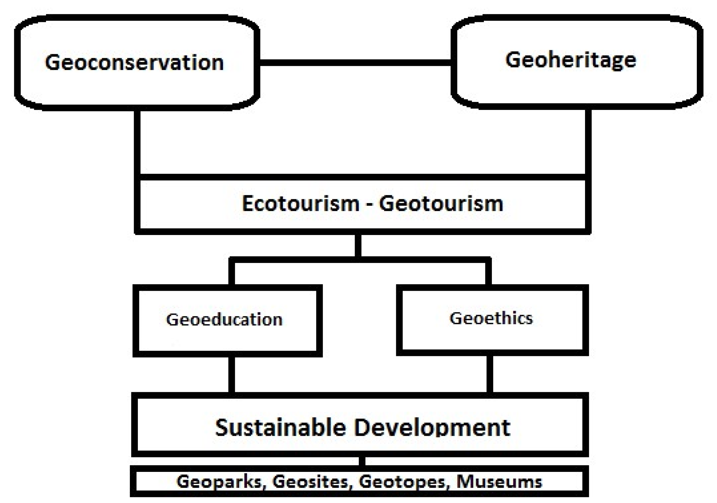
Consequently, it is understood that this new scientific field constitutes the forerunner for the most effective sustainability and its components (environment, economy, society). Therefore, due to the necessity created by the massive and systematic use of planet Earth, this new field focuses on the need for a more specialized knowledge of sustainability with the ultimate goal of disseminating knowledge through academia to society (
Figure 3) [
9].
Geoethics is primarily concerned with the most critical and pressing environmental issues, such as the greenhouse effect, climate change, pollution, and waste management problems. It also aims to promote critical thinking about the use of the natural resources of the earth, the development of environmentally friendly technological methods, and the dissemination of knowledge and information about natural hazards [
39]. The incorporation of geoethics into geotourism activities can raise the necessary awareness of sustainability, so that people in a local community perceive the rational use of resources and not take advantage of them. Accordingly, it is fully understood that human society must, in every action, respect the concepts of geodiversity and biodiversity and operate with respect, without negatively affecting any form of mapping of locations and formations that testify to the geohistorical evolution of the Earth and the monuments of geoheritage. Thus, the local community will be able to continue an activity, which will be based on the principles of geoethics and hence future citizens will be able to reap the benefits of the above actions [
46] without negative influences or results.
3. The Geological Heritage of GREECE and Its Peculiarities
3.1. The Geological Setting of Greece
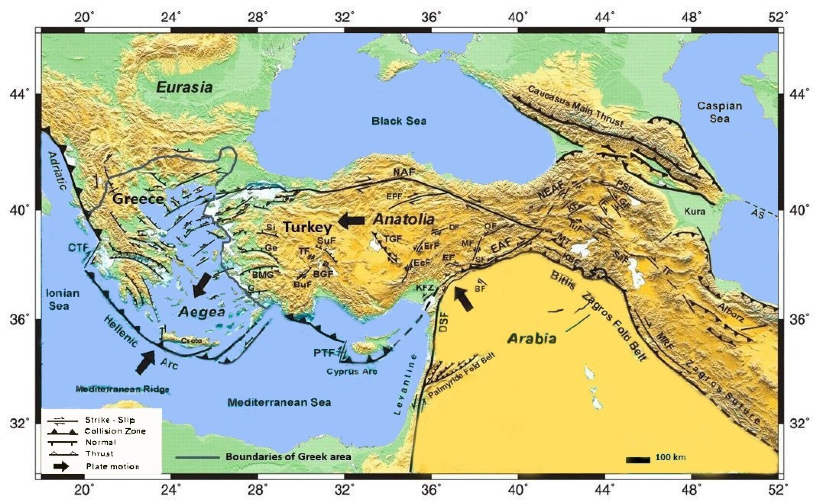
The Late Cenozoic evolution of Greece has been controlled by the northward subduction of the African plate beneath the Aegean lithosphere [
47,
48,
49,
50] (
Figure 4). As the African plate moves northwards, strike slip displacements along the Dead Sea fault zone causes compression between the Arabian and the Eurasian plates [
51]. This process results in a crustal thickening of East Turkey. As a result, the Aegean and Anatolia plates are being pushed westwards, causing the extension of the Aegean region towards the eastern Mediterranean (gravitational spreading,
Figure 5).
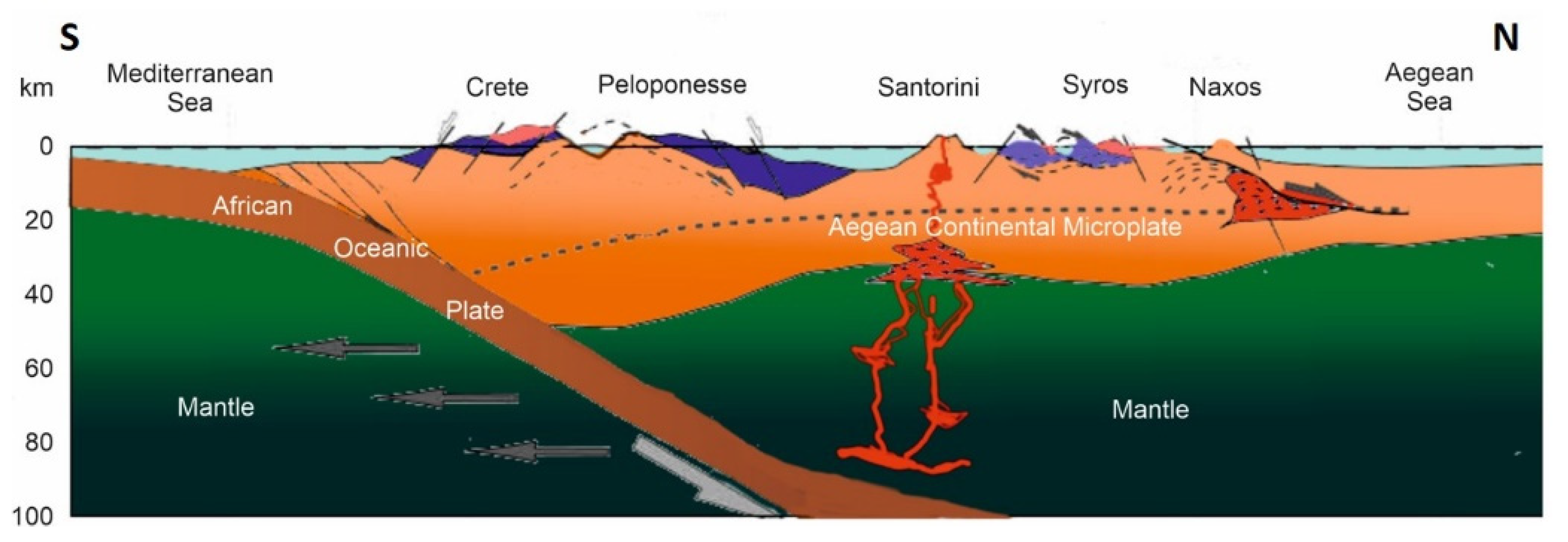
The gravitational spreading of the Aegean region towards the eastern Mediterranean is evidenced by the presence of a dense pattern of normal faults (Upper Miocene) and horst and graben structures [
48,
50,
52,
53]. Due to the extensional faulting, the crustal thickness of the Aegean plate is reduced, reflecting crustal attenuation [
54,
55]. For instance, the thickness of the Aegean crust in the Cretan Sea is not more than 20 km, which means that the crustal stretching must have been considerable there. According to Makris [
53,
54], the crustal thickness of the Aegean region is not constant, expressing the variability of the amount of stretching of the Aegean crust. The same author believes that this fact is due to spatial variations in the mode of tectonics in the Aegean plate. Indeed, apart from normal faulting, the Aegean region was also affected by rotational deformation since the Middle Tertiary. Angeller et al. [
56] described a 28° rotation of the Aegean area with respect to Eurasia, around a pole situated in the southern Adriatic Sea. This rotation caused the progressive extension of an inner landmass and the continuous readjustment to this extension of the Hellenic Trench [
57]. Since the Mio–Pliocene boundary (5 Ma), another clockwise rotation of 26° occurred in the western and northwestern Greece [
58,
59]. Palaeomagnetic studies show that this rotation did not affect the southern and southeastern part of the Hellenic Arc (Crete and Rhodes), so that a structural discontinuity between the western and the eastern part of the Hellenic Arc must be assumed [
60]. Because of this discontinuity, the western segment of the Hellenic Arc was marked by a compressional phase since the Mio–Pliocene boundary, which may be related to the continental collision of the Aegean domain with the Apulian continental margin (found west of the Ionian Sea) [
61,
62], whereas the southern segment remained under extensional conditions, except for short intervals of compression [
63].
Figure 4.
Sketch map depicting the geodynamic setting of Greece ([
64], modified by us).
Figure 4.
Sketch map depicting the geodynamic setting of Greece ([
64], modified by us).
Although the Aegean region is characterized by extensional tectonics, resulting in a steady subsidence, the Hellenic Arc has an elevated position relative to the Cretan Sea in the north (
Figure 5). Angelier and Le Pichon [
64], Angelier [
65], Le Pichon and Angelier [
66], and Angelier et al. [
56] attributed this uplift of the Hellenic Arc to a mechanism of crustal underplating, at least since the Middle Miocene. This would mean that sediments were removed from the subducting plate (African) to form the new basement of the Hellenic Arc [
67].
Figure 5.
Schematic reconstruction of the northward dipping Hellenic Subduction system (after [
68], modified).
Figure 5.
Schematic reconstruction of the northward dipping Hellenic Subduction system (after [
68], modified).
3.2. The Geological Heritage of Greece
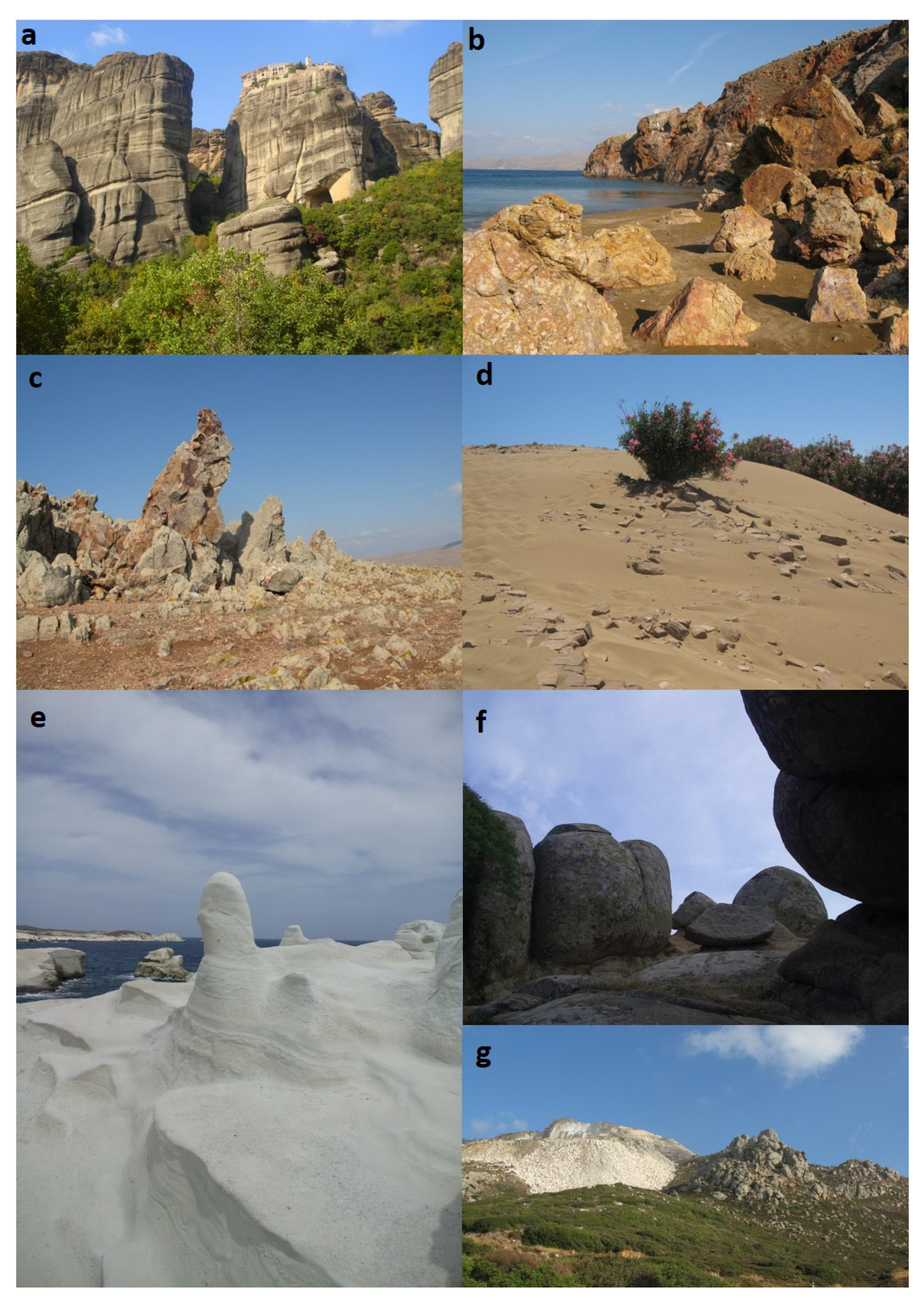
For the geological scientific community, Greece is a geological museum and a natural laboratory, where the course of the subduction of the African plate beneath the Eurasian can be studied [
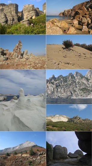
46]. Furthermore, the intense geotectonic processes in Greece, together with its archaeological and cultural wealth, make it a location deserving of preservation and promotion.
Greece has a range of geoforms and formations worthy of protection for world science and research, (e.g., [
46]). This is owing to its location within the convergence zone between two tectonic plates (African and Aegean microplates). As a result, Greece is well-known among geologists around the world as a “natural geological laboratory” that provides valuable information about global geodynamic processes due to its intense earthquake activity, volcanoes, diverse sediment processes, and littoral dynamics, among other things. At the same time, Greece is a great geomuseum, housing “moments” of the dynamic evolution of Earth, from the Proterozoic to the present. These “moments” are represented by geosites and geomorphosites, which are “portions of the geosphere that exhibit a particular importance for the understanding of Earth history”, [
69,
70]. These geosites or geotopes are scientifically, aesthetically, culturally, and ecologically significant (
Figure 6). However, ignorance frequently destroys these geosites in an irreversible manner. The Meteora, the Olympus Mountain, the Samaria Gorge in Crete, the ancient Lavrion mines in the Sounion National Park, the Petrified Forest of Lesvos, the Vicos and Aoos Gorges in Epirus, the Diros Caves in Peloponnesus, the Santorini Volcanic Caldera, the Prespes Lakes in West Macedonia, and the Falakron Mountain—Aggitis Karstic System in East Macedonia are some of the most significant geosites, which constitute well-known, legally protected and developed tourist attractions with thousands of visitors each year [
5,
46]. Moreover, Greece hosts six of the global geoparks of UNESCO: the Petrified Forest on the island of Lesvos, the Vikos–Aoos National Park in Epirus, the Chelmos-Vouraikos National Park in the Peloponnese, the Psiloritis National Park on Crete, the Sitia Nature Park on Crete, and the Grevena–Kozani Geopark.
The UNESCO Global Geopark of Lesvos Island (since 2004), formerly known as the Lesvos Petrified Forest Geopark, is a founding member of the Geoparks Network. It hosts an ancient forest that was preserved by a massive volcanic eruption that occurred 20 million years ago. Furthermore, in the Lesvos Island UNESCO Global Geopark area, there are discoveries of the oldest known land mammal (
Prodeinotherium bavaricum) 19 million years ago in Greece; impressive fossils of animals that lived on Lesvos 2 million years ago; numerous volcanic sites and thermal springs, witnesses of intense volcanic activity (21.5–16.2 million years ago); and faults and landscapes created by tectonic activity [
71].
The Psiloritis UNESCO Global Geopark (since 2004), is located on the Greek island of Crete, covering an area of approximately 1200 km
2. It encompasses the entire central region of the island, including the entire area of Mountain Idi (Psiloritis), Crete’s highest point, reaching a height of 2456 m. The Geopark is distinguished by its exceptional geodiversity. This is reflected in a wide range of volcanic, sedimentary, and metamorphic rocks dating from the Permian to the Pleistocene (300 to 1 million years ago), as well as spectacular folds and faults, fascinating caves, and deep gorges with a diverse biodiversity. These are exposed in a number of excellent outcrops and cross-sections that provide insight into the mountain-building processes of Earth [
72].
The Vikos–Aoos UNESCO Global Geopark is located in Ioannina, Epirus, in northwestern Greece. It is located in the northwest corner of the Pindus Mountain Range and is distinguished by high rugged relief and an impressive landscape. It includes Mt. Smolikas (2637 m asl), Greece’s second highest peak, Mt. Tymfi (2497 m asl), and the two spectacular gorges of Vikos and Aoos. The Vikos–Aoos UNESCO Global Geopark is composed of deep sea sedimentary rocks that were folded and faulted by the powerful compressive movements that prevailed in the Greek area 20 million years ago as a result of the collision of African and Eurasian plates. An ophiolitic complex is part of the UNESCO Global Geopark [
73].
The Chelmos–Vouraikos UNESCO Global Geopark (since 2009), is located in North Peloponnese, Greece, approximately 200 km from Athens. Chelmos Mountain evolved many distinct forms over millions of years due to the action of water and other natural factors, such as the impressive Vouraikos gorge, the beautiful Cave of the Lakes, the cold springs of Aroanios river, the mythical waters of Styx, and the Tsivlos and Doxa lakes. Lakes can be found not only on the surface, but also underground, and the Cave of the Lakes can be discovered by visiting three of its thirteen underground lakes [
74].
The Sitia UNESCO Global Geopark is located on the easternmost edge of Crete and is characterized by numerous Pleistocene mammal fossil sites, the discovery of three
Deinotherium giganteum fossils, the extensive cave systems, and the paleo-shorelines. The abundant karstic structures on the limestone environment constitute the most profound geological feature. To date, more than 170 caves and numerous gorges have been discovered in the surrounding area [
75].
The Grevena–Kozani UNESCO Global Geopark (since 2021) is one of the global geoheritage sites related to the birth of plate tectonic theory, as well as the expression of this tectonic legacy as the source of exceptional landforms and unique ecological systems. The region contains the oldest rocks discovered in Greece to date, as well as sites that reveal the geologic history and rifting processes surrounding the “birth” of the Tethyan Ocean and Europe as an independent continental mass [
76].
3.3. Institutional Framework–Legislation
Greece has been identifying natural areas and placing them under special protection since 1937. Natural areas are designated as protected areas via existing national legislation, international conventions, or international or European efforts. Furthermore, the sites of the Natura 2000 network are important locations for the conservation of natural habitats and wildlife and plants. In many cases, the same area is frequently listed at the national, European, and international levels. In terms of national legislation, the declaration of protected areas in various categories of protection was based primarily on Forest Law up to 1986. Law No. 996/1971 establishes National Woodland Parks, Aesthetic Forests, Natural Monuments and Landmarks. Law No. 177/75, as revised by Law N. 2637/1998, establishes wildlife refuges, controlled hunting areas, and game breeding stations. The Environmental Protection Law was afterwards enacted. Following the IUCN standards, Law N. 1650/86 established five distinct categories of protected areas:
Until 1986, some geotopes were protected by forest and archaeological legislation. The geological heritage of Greece is not officially protected, despite the fact that it is well-known and documented. Greece has adopted all relevant international conventions, and the institutional system in place ensures that even individual geotopes surrounded by incompatible practices of the gentle and sustainable development model can be preserved and enhanced (i.e., urban environment, industrial park, etc.). The new Biodiversity Law 3937/2011 has significantly strengthened the protective system established by Law 1650/86 for the category “natural formations-landscapes- components of landscapes”. This law expressly protects functional portions of nature or human creations that are scientifically, ecologically, geologically, geomorphologically, or aesthetically significant, and so contributes to the conservation of natural processes and the protection of natural resources.
Despite the efforts of the scientific community, no national geosite inventory exists. The first systematic registration of geological monuments was carried out in 1982 by the Institute of Geology and Mineral Exploration (IGME) of Greece on behalf of the Ministry of Culture. This, however, focused on the monumental character of the selected geomorphs. A broader effort was made as part of the GEOSITES program of UNESCO, which aimed to create a global list of geosites. The Greek Geosites project was developed by the Institute of Geological and Mineral Research (IGME), which participated in the ProGEO Executive Secretariat as coordinator of the South East Europe Working Group [
70]. In 1995, IGME attempted to develop a working group for the protection of the geological heritage of Greece, which was later expanded with the participation of scientists from universities and other institutions. Over time, IGME has made a significant contribution to the protection of national Geo heritage (Geotopes–Geopaths–Geoparks) having prepared comprehensive management plans for its systematic registration and promotion. The initiative of IGME in 2005 to include a project, on one hand, for the systematic registration of geotopes based on geoscientific, educational, or tourist value, and on the other hand, for the selection of sites as potential geoparks, in the Third Community Support Framework, deserves special mention. Since then, the issue has been included in various sub-projects of the NSRF, resulting in the completion of the systematic inventory project and the development of an interactive GIS system, which describes the geotopes registered so far, the geopaths, and the institutionalized geoparks of Greece. The GIS presents both the geospatial data and the metadata and information about the European geoparks as well as the Greek geopaths that have been investigated by IGME.
The Commission for the Enhancement of Geological and Geomorphological Heritage was established by the Geological Society of Greece in 2004 to coordinate scientific activities in geoconservation.
The first attempt at an open discussion on the issue of preservation of the geological heritage in Greece took place in 1996 in Ermoupolis, Syros. Four years later, in 2000, the mentioned terminology was consolidated by the Academy of Athens. In this way, it was realized that there was a more systematic way of recording potential geotopes, with the goal of designating a part of them as geoparks.
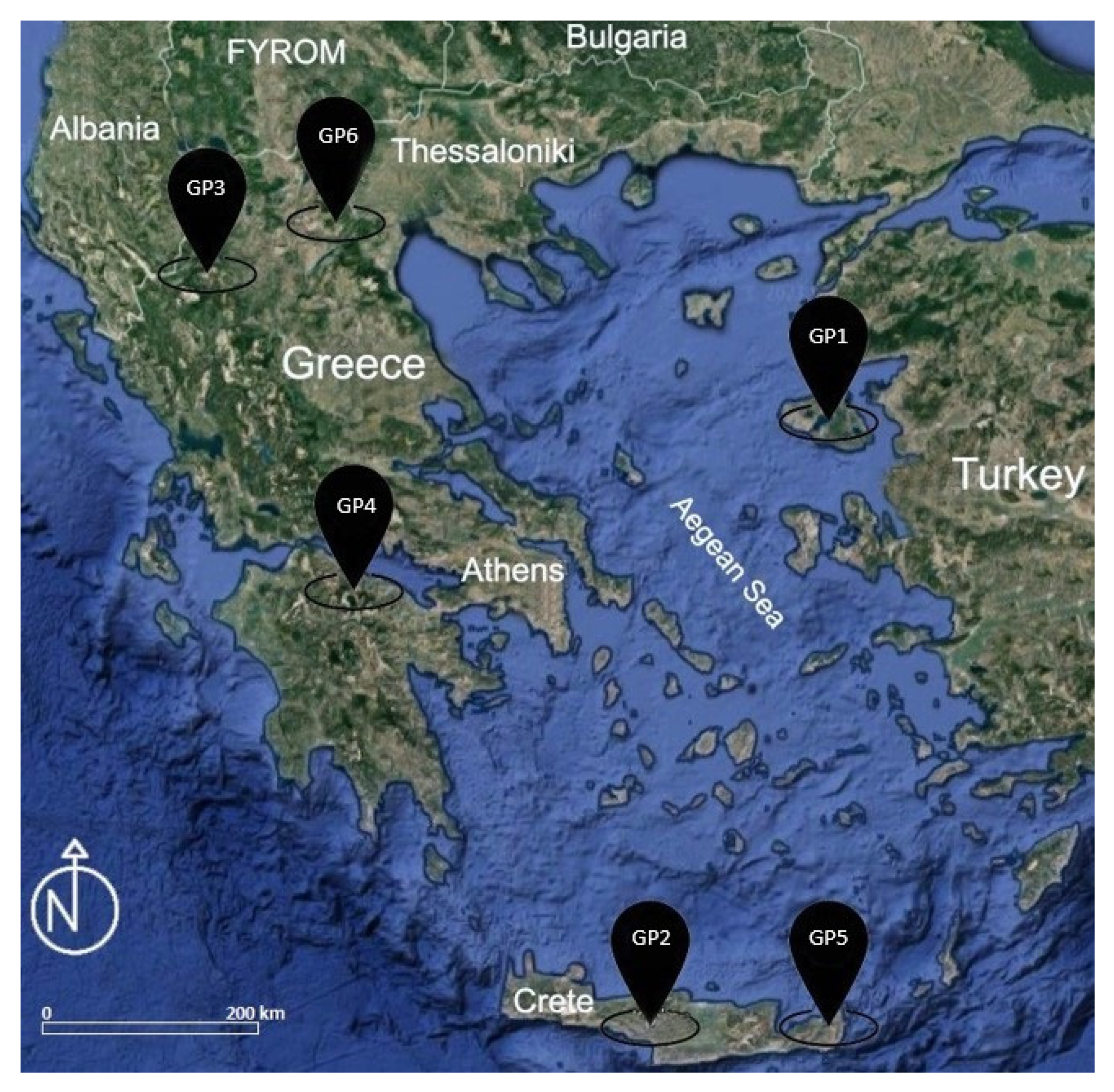
In addition, it is worth mentioning that the large presence of strong geological monuments in Greece resulted in the recognition of six geological parks (
Figure 7). Initially, in 2000, the area of the Petrified Forest of Lesvos was recognized as the first geological park in Greece and was a founding member of the European Geoparks Network. Further, in 2012, the entire island of Lesvos was designated as “Lesvos Island UNESCO World Geopark”. Additionally, in 2001 followed the recognition of the Psiloritis geopark (Psiloritis Natural Park) in Crete. It should be emphasized that these first two geoparks contributed to the establishment and characterization of the other geoparks both in Greece and at European level. Later in 2009, the Chelmos–Vouraikos Geopark in the Peloponnese was recognized; in 2010, the Vikos–Aoos Geopark in Epirus; in 2015, the Sitia Geopark in Crete; and finally, in 2021, the Grevena–Kozani Geopark was included.
3.4. Geoeducation in Greece
Geological education seeks to promote geological thinking through geological knowledge, with the goal of positively influencing issues of public concern. This knowledge is imparted in the Greek educational system through a course in primary education. However, this course is taught by unskilled staff as part of the Geography course and even at certain times during the thematic units [
77]. Moreover, in secondary education, particularly in the first and second grade of high school, the subjects of Geology and Geography are only taught for one and two hours, respectively, per week. These two curricula do not place enough emphasis on geoheritage, the palaeontological significance of specific geological sites, and fossilized areas that represent the evolution of our planet [
78]. As a result, the education of Greek students in geological and geoenvironmental issues is limited to inadequate [
79,
80]. Because of this, when students complete elementary school, they lack a fundamental understanding of geosciences, which are crucial in the daily lives of citizens [
79,
80]. According to the statistical study of Georgousis et al. [
81], it appears that most Greek school children and students lack adequate knowledge and understanding of geoheritage and its significance. The outcome of this research indicates how important it is to introduce and implement geoenvironmental education rather than simply environmental education. It is also important to have well-trained staff in the Greek education system, able to transfer the necessary knowledge and the importance of geoenvironmental concepts to students. According to Georgousis et al. [
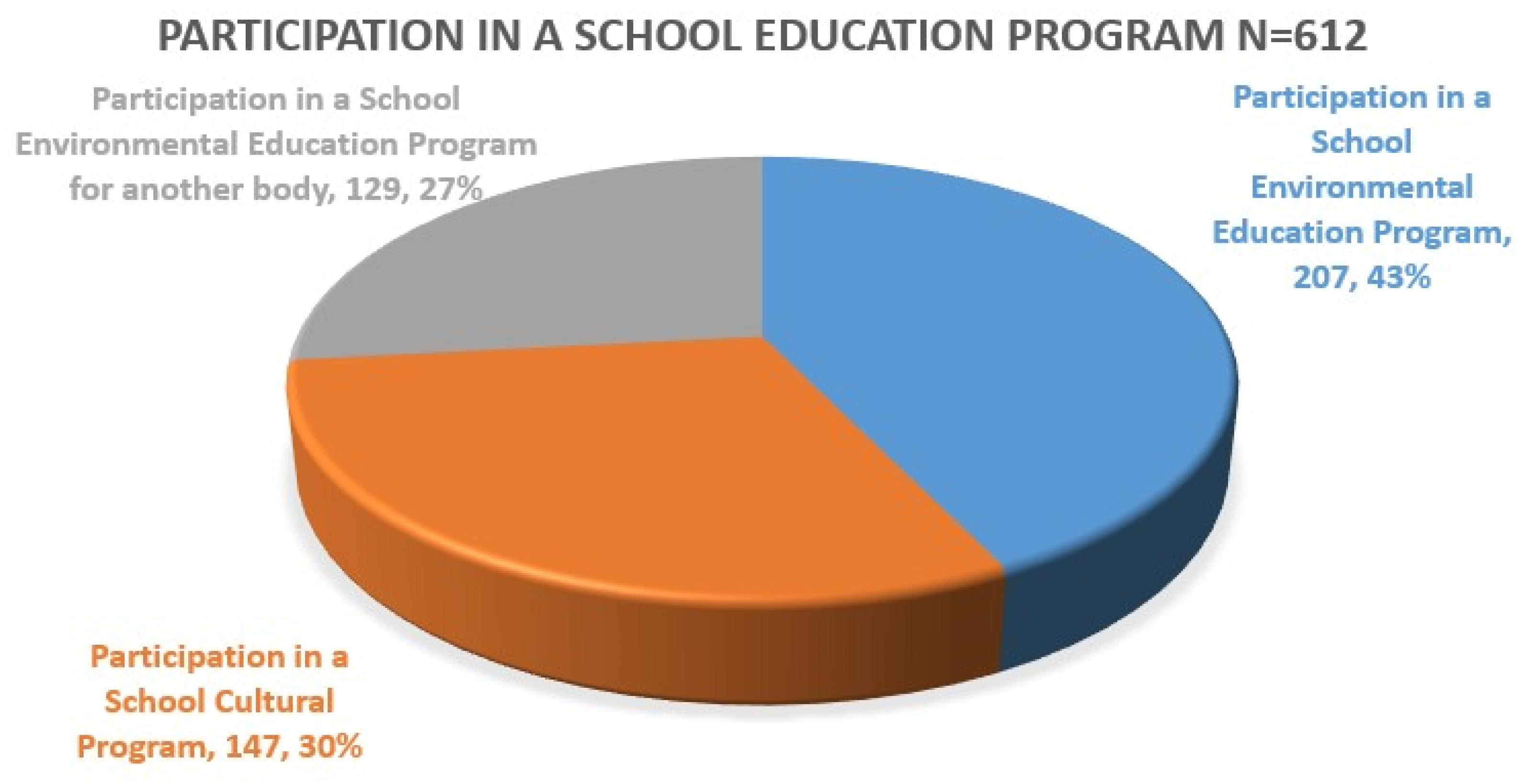
81], in which 612 pupils and students participated, a lack of participation of pupils, primarily in geoenvironmental education programs, was initially apparent. However, the findings of the study revealed that 43 percent of students participate in school-based environmental education programs. Then, with a percentage of 30%, it appeared that students participate in cultural educational programs, and finally, only 27% of students participate in educational programs that take place outside school activities (
Figure 8) [
81].
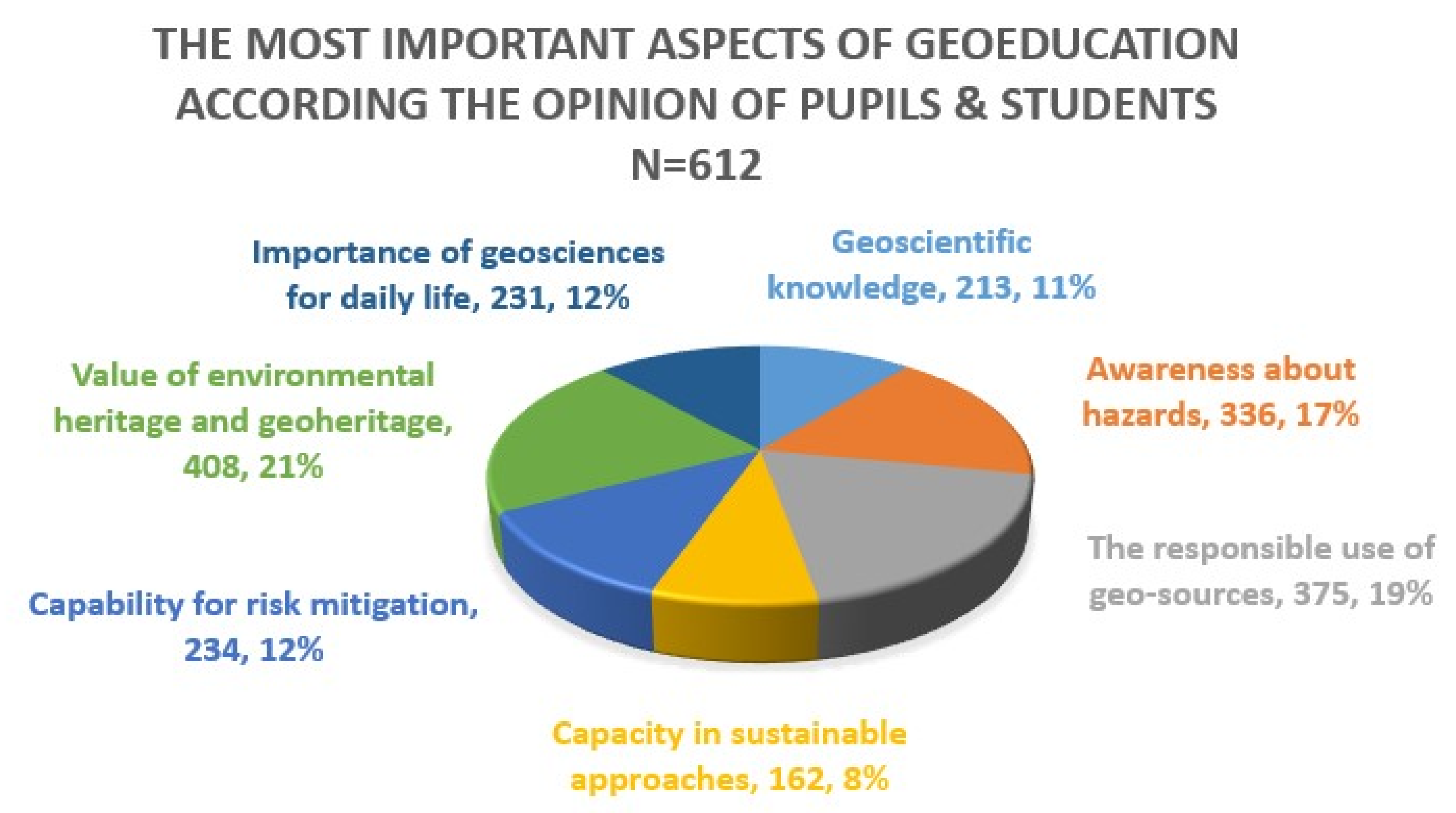
Furthermore, the findings of this study are critical in terms of the most important aspects that emerge from the implementation of geoeducation. Twenty-one percent of participants stated that geoeducation is related to environmental heritage and geoheritage (
Figure 9). According to 19% of participants, geoeducation is related to the proper use of geological sources. Seventeen percent of participants believe that geoeducation is associated with hazard awareness. A percentage of 12 percent relates the concepts of geosciences with everyday life and the ability to mitigate risk. Finally, 11% of participants stated that geoeducation is related to broader geoscientific knowledge, while 8% thinks that geoeducation is related to capacity in sustainable approaches [
81].
To summarize, there is a clear lack of geoenvironmental education in the Greek educational system, which means that the next generation does not understand the value and importance of protecting geological heritage. Understanding the value of Greek geological heritage will lead to the emergence of other aspects of Greek society, such as cultural and archaeological heritage.
3.5. State of Development of Geotourism in Greece
Tourism is one of the most important pillars of growth and revenue for the Greek economy. The contribution of tourism to GDP was estimated at 16.2% for 2009, which corresponds to approximately 35 billion EUR [
82]. Greece has established itself among the top tourist destinations internationally. However, the future of the Greek tourism product should not be considered guaranteed. Maintaining high growth rates of tourist arrivals and receipts, despite increasing competition, is vital to the national economy.
Geotourism is an alternative form of tourism based on the sustainable development and preservation of geological monuments, the natural environment, the cultural heritage, and the landscape. With its rich natural and cultural heritage, Greece has the potential to develop this specialized form of tourism. Geotourism has its own dynamics and is vying for a market share. Geotopes, geoparks, and natural history museums are the most common locations for geotourism activities, and as a result, geotourism can be a valuable opportunity for local community development with numerous benefits.
Crete is the region with the highest geotourism activity in the country [
83]. The South Aegean region also presents high geotourism activity. The regions of Ionian Islands and Attica present medium to high geotourist activity. The regions of Epirus, Peloponnese, and Thessaly present average geotourist activity.
Therefore, it is understood that the geotopes of Greece can play an important role in strengthening its tourism economy. It is a local low-cost tourism product that facilitates regional development [
83]. Geotourism is a “new” challenge for Greece, not only because it can redistribute the tourist product of the country to areas that were previously not tourist destinations, but also because it can stimulate a new quality tourist flow in the country. The usual forms of geotourism in Greece are cave tourism (only in tourist caves) and hot spring and spa tourism [
84,
85]. Greek geotopes, however, can support other activities, targeting a wide range of citizens. In recent years, there has been adequate mobility in Greece for the promotion of geological heritage and geotope management, primarily through the IGME project. This project aims to systematically register geotopes based on criteria such as geoscientific, educational, or tourist value, to identify georoutes, to promote and include Geoparks in the global and European network, to select areas as potential geoparks, etc.
Geotourism, in general, can be one of the main pillars of rural tourism in Greece. In most cases, the “geotourism product” is part of the overall rural tourism product [
86] (agrotourism, cultural tourism, adventure tourism), from which it cannot and therefore should not be separated. There are also instances where the “geotourism product” can be incorporated into the main tourism product of the country, to the extent that the dominant and most popular form of tourism (sun and sea) is differentiated and enriched in the direction of sustainable tourism development.
4. Discussion
It is well documented in the scientific community that Greece, as a tectonically active country, constitutes a Natural Geological Laboratory and Museum, which must and can be used for information and education and consequently public awareness.
The Greek natural environment, particularly the living flora and fauna, has been documented, studied, and evaluated. The geoenvironment, on the other hand, despite being the foundation of fauna and flora as well as the framework of spatial planning and development policies, has not yet been fully studied and researched, and its protection is insufficient. This is evident from the lack of geoenvironmental education within the curriculum of Greek schools and universities [
81]. The question is whether sustainable development and interdisciplinary knowledge and interpretation of the environment can be understood in the absence of knowledge and integrated geoenvironmental management.
According to the literature review and our personal opinion, the following are some of the reasons for Greece’s lack of geoenvironmental promotion, protection, and integrated management:
Since the establishment of the modern Greek state, Greek geoscientists have played a minor or non-existent role in the effort to locate raw materials, such as energy and quarry reserves, as well as in the study and construction of large development projects;
The rapid passage of Greek society from the phase of survival in the phase of consumerism–eudemonism;
The environment is viewed as a consumer good;
The misconception that the geoenvironment accepts and offers endlessly;
The time lag with which our country implemented international conventions and European Union legislation concerning the natural environment;
Inadequate understanding of the importance of geological knowledge and heritage;
The failure of the Greek state and society to recognize the importance of the role of geoscientists, geological knowledge, and its applications in the country’s development process;
The absence of a geoenvironmental pedagogical, educational, and recreational dimension;
Greece’s inability to function as an open natural geological museum;
The exploitative and piecemeal approach to the geoenvironment;
Inability to adapt the activities and services provided by each geoproduct and resource category (spa, caves, gorges, waterfalls, thermal springs, etc.) to changes in Greek society;
The inability of the Greek society to identify with new data on multiculturalism, mobility, the global market, and the economy.
It is common for society to disregard the values contained in the geoenvironment, which is characterized by a wide range of phenomena and processes, and is a witness to human civilization and geological phenomena. All this makes it a destination for scientific study and observation of phenomena, as well as recreational space and human contact with nature. The geoenvironment, with its constraints and opportunities, serves as the foundation for development planning. For this reason, the involvement of geoscientists in the problems of the Greek development model of Greece, as well as the increased social interest in the environment and its protection, especially in recent years, require the review of attitudes and policies related to the geoenvironment.
Based on the above findings, the goals for the near future should be:
The recording and investigation of the existing institutional framework of the geoenvironment;
The recording of the existing reality of the utilized or not, but visitable natural habitats—the caves, the waterfalls, the gorges, and the thermo-mineral waters, as well as the man-made habitats—the museums of natural history, canals, etc.;
Exploring the development dimension of geotopes as attractions at local, regional, and national scale;
The promotion of geological heritage and the determination of methods for its protection;
The emergence of geotourism;
The use of geological monuments for educational purposes in primary and secondary schools, particularly in environmental education;
The possibility of using the geoenvironment as an open geological laboratory-museum for higher education;
Assessing the need for new specialties such as land conservators, tour guides, etc.;
The diffusion of geological knowledge, science, and their applications in everyday life.
Exploring the relationships and interactions between the geoenvironment and folklore, literature, mythology, religion, photography, and philately;
The investigation of the relationship of the geoenvironment with the activities of man in his free time.
The designation of a location as a geosite does not ensure its preservation and protection. Geoconservation cannot be successful unless the public and the state are made aware of its importance. Through educational programs, particularly environmental education courses, young people can learn about their own local geological heritage. Education, particularly environmental education, can be a driving force behind successful land conservation.
The preservation of geological and geomorphological heritage through environmental education can be combined with strategies aimed at the socio-economic development of each region (e.g., development of alternative forms of tourism, such as cultural tourism, ecotourism, etc.) contributing to promoting the harmonious human–nature relationship.
It should be emphasized once more that the current system that governs education has degraded the position of geology in the Greek educational system. It is also requested that scientists with critical and creative thinking be trained to contribute to the resolution of energy issues or issues of management of Greece’s abundant natural resources, in order to provide Greece with the necessary economic impetus for long-term development and sustainability.
5. Conclusions
The aim of this review has been based on the current system in force for geological heritage, geodiversity, geoethics, and geoeducation, to demonstrate the current situation regarding the promotion and utilization of the geological heritage of Greece. The country is characterized by a complicated geological context and evolution, as well as a wide range of geomorphological processes that have resulted in a high level of geodiversity. As a result, it has many spectacular landscapes and outstanding or unique geosites, which, due to the lack of the appropriate legislation framework, are poorly managed and protected.
Greece occupies a unique position on the European geological map, with extensive areas of important geotopes containing, among other things, paleontological remains, rare geomorphological structures, and thousands of caves. Furthermore, this is the primary reason why the country has been a member of the UNESCO European Network of Geoparks since November 2015, with six geoparks (the fossil forest of Lesvos, Psiloritis of Crete, the area of Sitia, the National Forest of Vikos–Aaros, Vouraikos Peloponnese, and last but not least, the Grevena–Kozani geopark) among 81 geoparks in 26 countries in Europe.
Although the provisions of Law 3937/11 resulted in the definition, characterization, and process of characterization of geotopes, there is still an institutional and legal gap in geotope protection. The importance of establishing a legal framework for geotope protection is highlighted by the fact that their promotion and rational management creates opportunities for sustainable development, particularly in the rural sector, as well as becoming quality tourist destinations (geotourism) through nature protection and education. However, at national level, the importance of geotopes has, so far, been underestimated. The institutional framework that exists for the protection and preservation of the geological heritage is based on the necessity of issuing administrative acts and, to date, this has not been activated.
Finally, the need for geoenvironmental education at all levels of the Greek education system is emphasized which will lead to geoenvironmentally responsible citizens with developed geoethical values.


