Article

Bridges as Geoheritage Viewpoints in the Western Caucasus

by
Anna V. Mikhailenko
1,
Vladimir A. Ermolaev
2 and
Dmitry A. Ruban
3,4,*
1
Department of Physical Geography, Ecology, and Nature Protection, Institute of Earth Sciences, Southern Federal University, Zorge Street 40, 344090 Rostov-on-Don, Russia
2
Department of Commodity Science and Expertise, Plekhanov Russian University of Economics, Stremyanny Lane 36, 117997 Moscow, Russia
3
K.G. Razumovsky Moscow State University of Technologies and Management (The First Cossack University), Zemlyanoy Val Street 73, 109004 Moscow, Russia
4
Department of Organization and Technologies of Service Activities, Higher School of Business, Southern Federal University, 23-ja Linija Street 43, 344019 Rostov-on-Don, Russia
*
Author to whom correspondence should be addressed.
Geosciences 2021, 11(9), 377; https://doi.org/10.3390/geosciences11090377
Submission received: 8 August 2021 / Revised: 2 September 2021 / Accepted: 6 September 2021 / Published: 7 September 2021

Abstract

:
Distant observation of unique geological and geomorphological features facilitates comprehension and tourism of these important resources. Bridges offer an opportunity for such observation, and the idea of bridge-based geoheritage viewpoints is proposed. In the geologically-rich area of the Western Caucasus (southwestern Russia), eleven bridges were assessed semiquantitatively with the newly proposed approach. The results indicated their different but moderate utility as geoheritage viewpoints. The utility of two bridges is high. Bridges differ not only by the quality of the views they offer but also by their accessibility. Mandatory permissions and entrance fees reduce this property in several cases. Although the study area is somewhat specific due to the relatively large number of bridges and their utility, similar situations can be found in other geographical localities. Bridge-based geoheritage viewpoints are important to geotourism development, and, particularly, they contribute to establishing optimal and comfortable routes.

1. Introduction

Geoheritage and geotourism studies have intensified in the past decade [1,2,3,4,5,6,7]. Aside from documentation of hundreds (if not thousands) of new geosites, new dimensions of geoheritage diversity have been revealed. In particular, it has been realized that points suitable for the comfortable observation of unique geological and geomorphological features are important elements of geoheritage landscapes, and the most valuable of them can be judged as true geosites (even if they do not expose any unique features). The idea of viewpoint geosites was proposed by Fuertes-Gutiérrez and Fernández-Martínez [8] and Palacio [9] and then developed and conceptualized by Migoń and Pijet-Migoń [10], with some subsequent additions by Mikhailenko and Ruban [11]. There were also several other works, which considered viewpoints in relation to geoheritage management in different parts of the world [12,13,14,15,16,17].
Fuertes-Gutiérrez and Fernández-Martínez [7] and Migoń and Pijet-Migoń [9] noted that viewpoint geosites can differ significantly, and they can be either natural and artificial. One can imagine many objects, standing on which offers views of unique geological and geomorphological features and panoramas of geoheritage landscapes. Evidently, the practical importance of such objects is outstanding because they facilitate inventory and monitoring of geosites for the purposes of geoconservation, as well as enhancing comprehension of geoheritage by visitors and provide emotional satisfaction [7,17]. Therefore, establishing a diversity of viewpoint geosites and paying attention to their particular types are crucial research tasks. Field investigations in the Western Caucasus—a large mountainous domain in southwestern Russia—have shown the importance of numerous bridges for the distant viewing of geoheritage features.
The objective of the present paper is to characterize the bridge-based geoheritage viewpoints of a particular geologically-rich area of the Western Caucasus. This area is known as Mountainous Adygeya, and it lies near the border of the Republic of Adygeya and the Krasnodar Region (Figure 1). Terminological and methodological solutions are also offered in this paper. More generally, the latter aims to promote bridges as important elements of geoheritage landscapes facilitating efficient management of these landscapes.

2. Methodological Remarks
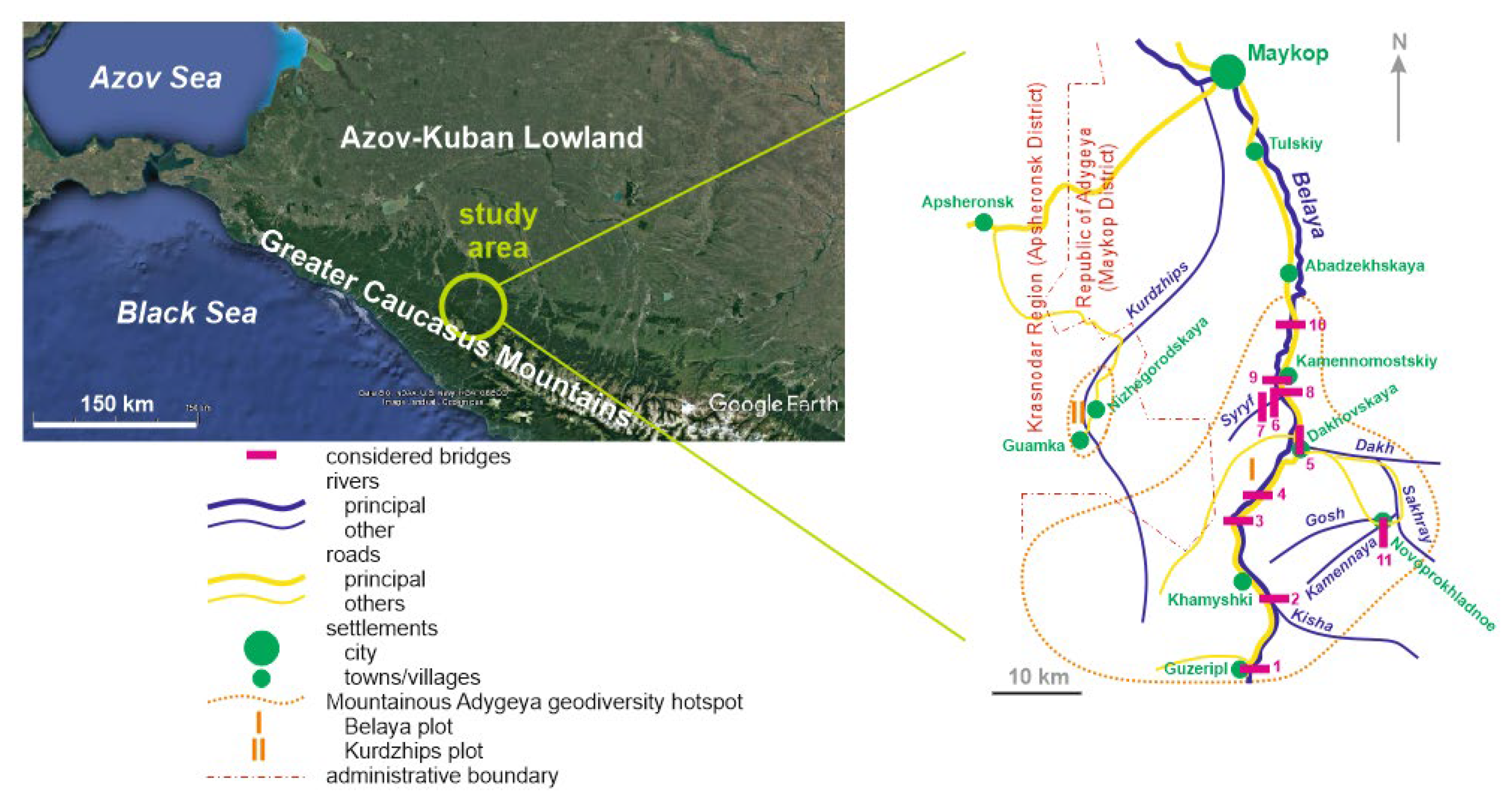
2.1. Study Area

The study area is situated in the Western Caucasus, which is the western segment of the Greater Caucasus mountain chain and the related late Cenozoic orogen (Figure 1). The general geographical and geological setting of this large domain was characterized, particularly, by Adamia et al. [18], Frolova [19], Kaban et al. [20], Lurie et al. [21], Rantsman [22], Van Hinsbergen et al. [23], and Viginsky [24]. More precisely, this area corresponds to the Mountainous Adygeya geosiversity hotspot boasting numerous and diverse unique geological and geomorphological features [25,26]. Administratively, this area belongs to the western and central parts of the Maykop District of the Republic of Adygeya and the eastern part of the Apsheronsk District of the Krasnodar Region. Geographical and geological characteristics of this area can be found in the works by Lozovoy [27], Rostovtsev et al. [28], and Ruban [29], and these characteristics are described briefly below.
The study area is dominated by mountains with a height from 500–700 m to >2500 m. Mountain ranges are generally short (<10 km), and many of them are cuesta-type ranges (sensu [30,31,32]). The southwestern part of the study area is occupied by the Lagonaki Highland with a height of >1800 m. The climate is temperate with rather mild winters and rather hot summers. The annual rainfall reaches 700 mm, and the Lagonaki Highland is one of the wettest places in Russia, with an annual rainfall of up to 3000 mm and more. Winters are characterized by strong snowfalls. Deep river valleys either cross mountain ranges and cut narrow canyons and gorges, or, in contrast, they stretch along ranges and form wide valleys with well-developed terraces. The principal river is the Belaya River, which is a left tributary of the larger Kuban River (one of the largest rivers of the Russian South). The other rivers and streams are elements of the dense drainage network of the Belaya River. The study area is covered by dense vegetation, including deciduous, coniferous, and mixed forests, meadows (both Alpine and riverine), and plots of true steppe (grassland). The human settlement is not dense: the population is <20,000 in the area of ~150 km2, and it is concentrated in a few towns and villages (no detailed statistics are available). Nonetheless, there is a rather developed road infrastructure (Figure 1). Notably, Mountainous Adygeya is one of the most important tourist destinations of the Russian South [33], attracting up to 0.5 million of visitors annually [34] (this is approximated, and the true tourist flows may be stronger—detailed statistics are absent).
Geologically, the study area is diverse, and it is dominated by the Mesozoic deposits accumulated in the tropical Caucasian Sea, which was a marginal semienclosed sea of the Tethys Ocean. The most widespread rocks are Early–Middle Jurassic shales and Late Jurassic limestones and dolostones. Precambrian metamorphics and Late Paleozoic granitoids crop out in the central part of the area, and the Early–Middle Permian molassic sequence is exposed in its southern part. Cretaceous siliciclastics and carbonates crop out in the northern part of the area. The Hercynian, Cimmerian, and Alpine phases of tectonic deformations resulted in highly-complex folding and faulting. Fifteen geosites (some of them are also geomorphosites sensu [35,36,37]) represent unique geological and geomorphological features of Mountainous Adygeya [25,26], some of which are ranked nationally and even globally.
The material for the present study was obtained in the course of field investigations in Mountainous Adygeya, and the majority of observations were made during the field campaign in summer 2021. A total of eleven bridges were visited and examined in regard to their utility for distant viewing and comprehension of the local geoheritage landscapes (Figure 1). This material is used to develop and test the approach explained below.

2.2. Terminology and Approach Proposal

A bridge not only connects two points/places divided by a topographic low or any other natural/artificial barrier (river, road, etc.), but it is also a relatively high point offering views of the surrounding landscape into two opposite directions (from both sides of bridges). Consequently, bridges are among potential viewpoints for distant sometimes panoramic viewing of geoheritage. Indeed, such a function works if unique geological objects are available near a given bridge and can principally be visible from there (for instance, if they are not masked by vegetation or located too far away to be recognized).
Relating bridges to geoheritage requires certain terminological justifications. Fuertes-Gutiérrez and Fernández-Martínez [8], Palacio [9], and Migoń and Pijet-Migoń [10] argued the importance of viewpoints, and the term “viewpoint geosite” has been coined. The specialists broadly agreed that such sites are characterized by duality (observation point and observable object), and they are very important for geoheritage comprehension. An attentive reading of the noted works [8,9,10] implies the existence of two categories of such sites, namely “ordinary” viewpoints allowing observation of distant geoheritage features and viewpoints allowing distant features to be recognized as really unique. Apparently, the only latter can be judged as true geosites. The situation is even more complicated because an “ordinary” viewpoint may provide exceptional opportunity to observe one distant geosite, several geosites, or even the entire geoheritage landscape (unique features in their broad geological and nongeological contexts). It would be wrong to not link such viewpoints to geosites. Regarding the above, it is sensible to specify geoheritage viewpoints as a broad category, and viewpoint geosites as its subcategory. The former embraces all points from which unique features are visible, and the latter are the most important of them. Viewpoint geosites themselves may or may not have some heritage value (cf. [10]), and they are something in between physical geosites (i.e., geosites with intrinsic value) and the so-called “virtual” geosites (sensu [5,38]). Technically, all geoheritage viewpoints are of utmost importance, as they facilitate geoconservation and geotourism (see above). They can be nonheritage sites, viewpoint geosites, or particular elements of large linear or areal geosites. When bridges make unique features visible, these are bridge-based geoheritage viewpoints, and this provisional term is employed in this study. Bridges can be added to the other sorts of manmade viewpoints distinguished by Migoń and Pijet-Migoń [10]. It should be added that some bridges constructed for tourism are located in places with panoramic views and high aesthetic properties.
Field excursions in geologically-rich areas allow easy identification of bridge-based geoheritage viewpoints. Their number depends on the drainage network density and the development of socioeconomical, transport, and touristic infrastructure of a given territory. However, this simple identification is not enough. The utility of some sites is larger than that of the others, and, thus, their assessment is necessary. Migoń and Pijet-Migoń [10] proposed a set of criteria for assessment of viewpoint geosites, and this can be used to develop a semiquantitative scoring-based approach for the assessment of bridge-based geoheritage viewpoints. The other developments of geosite assessment, which often consider panoramic viewing (e.g., see review in [39]), are also taken into account. Two remarks are necessary. First, this approach emphasizes the “technical” properties not the uniqueness of the observable features, because not all geoheritage viewpoints are viewpoint geosites (see above), and this uniqueness may or may not be understood distantly. Second, bridges have some specific properties, which need to be taken into account. In other words, bridge-based geoheritage viewpoints cannot be accessed exactly as viewpoint geosites or any other geosites.
The criteria and the related scores proposed for the semiquantitative assessment of bridge-based geoheritage viewpoints are summarized in Table 1, and several clarifications are provided below. First, if a given bridge is wide, it cannot offer a 360° panorama, but it provides two views (for instance, two 180° panoramas) from each side. Second, unique geological and geomorphological objects may not be visible from any side of a given bridge due to the curvature of slopes, dense vegetation, shadows, and constructions, or even may not exist. Third, the bridges accessible by only cars or trains are less valuable than the bridges accessible by only pedestrians because the flow of cars or trains cannot stop to allow observation of distant features. Fourth, in cases of required permissions or entrance fees, bridges lose a significant part of their accessibility, as permissions are not always easy to obtain and not all visitors are ready to pay for “just viewing”. Fifth, there are bridges that are challenging for some (if not many) visitors to walk along. This is the case with too old or damaged bridges. In Mountainous Adygeya, there are several rather long (up to 200 m and more) hanging bridges. Although they are accessible to pedestrians, some visitors are not prepared (more psychologically than physically) to walk along them due to their swinging or feel discomfort standing in the center for “lazy” viewing. Moreover, bridge swinging complicates taking photos. Indeed, this is a serious limitation to accessibility.
Each given bridge can easily be assessed by the proposed criteria (Table 1), and, the total score indicates its relative utility. As for the latter, it is proposed tentatively to differentiate utility into three grades, i.e., low, high, and moderate utility. Indeed, the set of criteria and the related scores are provisional and can be justified in the course of further investigations. Nonetheless, they reflect the diversity of situations one can face in reality, and many of these situations were encountered during field investigations in the study area.

3. Results

The application of the proposed approach to the eleven bridges of Mountainous Adygeya enabled characterizing them individually and generally. This information is presented below. Additionally, one bridge was selected to demonstrate how the approach worked in detail.

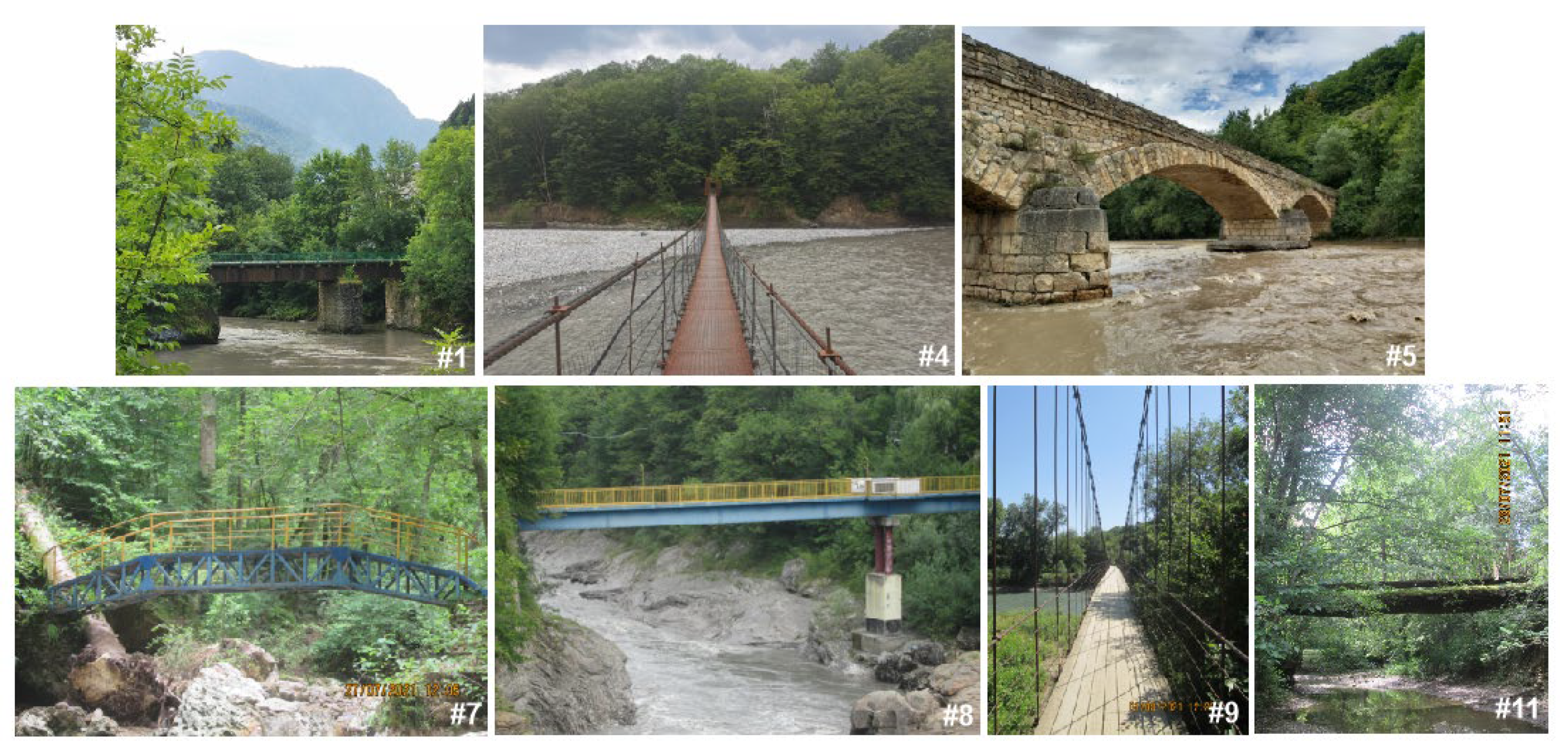
3.1. General Characteristics
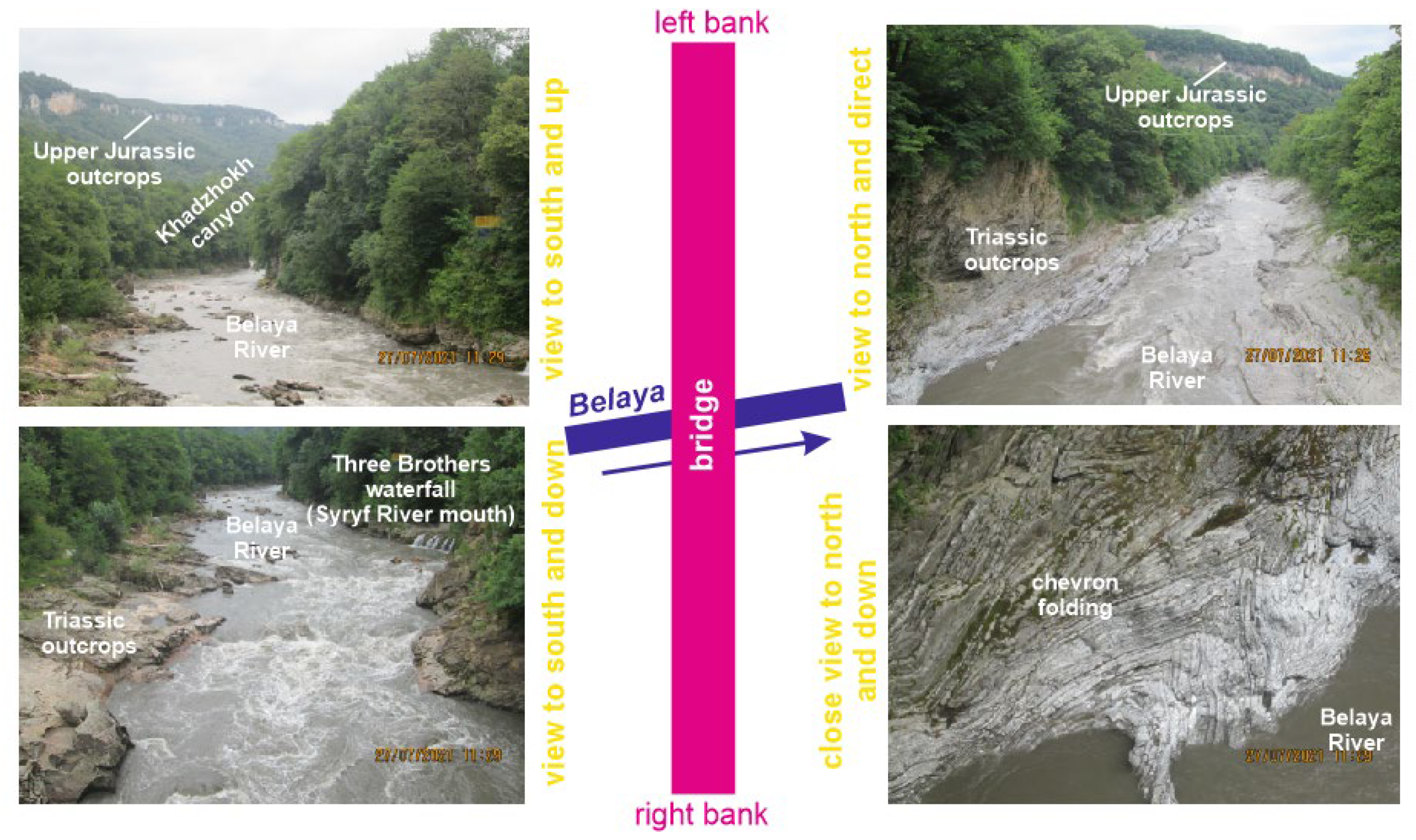
Eleven bridges were judged as geoheritage viewpoints in the study area (Figure 1 and Figure 2, Table 2). Importantly, these are found in different parts of the Mountainous Adygeya geodiversity hotspot. Many of them are bridges along the principal road connecting Maykop and Guzeripl. This road stretches through the area from the north to the south, and it crosses the Belaya River and its tributaries several times. Some bridges have been constructed for the local needs, and some are elements of the local touristic infrastructure. Three general types of bridges are distinguished, namely capital constructions (usually made of concrete), light constructions (metallic and woody, often mixed), and hanging constructions (usually metallic with woody pavement) (Table 2).
The considered bridges differ by their view and age, although all connect river banks (Figure 2). One bridge was constructed at the beginning of the 20th century with old technologies (#5 on Figure 1 and Figure 2); now, this is a double bridge consisting of an old bridge and the parallel modern bridge. The majority of the bridges were constructed in Soviet times, with common maintenance in postSoviet times (for instance, #9 on Figure 1 and Figure 2). Several bridges were constructed as elements of the tourist infrastructure in the mid-2000s (for instance, #4, #7, and #8 on Figure 1 and Figure 2). Importantly, all these bridges are high and long, and they offer spectacular views of the geoheritage landscapes.
The properties of the bridge-based geoheritage viewpoints differed substantially (Table 2). First of all, the bridges provided different possibilities for viewing geoheritage. Interestingly, the hanging bridges (for instance, #4 on Figure 1 and Figure 2) were ideal objects offering 360° panoramas because they were narrow. In several cases (for instance, #7 on Figure 1 and Figure 2), the bridges crossed narrow river valleys with rather steep slopes and dense vegetations and shadows, as a result of which the views were restricted. The visibility of unique features also differed (Table 2). It was excellent in many cases, when visitors could see details of the geological and geomorphological objects. However, it was lower in many other cases. For instance, the bridge over the Dakh River (#5 on Figure 1) offered an excellent opportunity to enjoy the 180° panorama of the cuesta-type range. However, its scarp with outcrops of the Late Jurassic carbonates was visible from such a distance as a very narrow yellow strip, which could not be understood correctly without specific knowledge. Moreover, the frontal view of the cuesta scarp complicated interpretation of this landform.
The diversity of the visible features was generally low (Table 2). With one exception (see example below), the number of these features did not exceed three. The most striking difference was linked to accessibility (Table 2). It was low in the case of the hanging bridges, but it was even lower when permissions are required. For instance, the bridge over the Belaya River near the mouth of the Kisha River (#2 on Figure 1) offered a spectacular view of the red-colored Early–Middle Permian molassic sequence, which is a legacy of the Hercynian orogeny in the Greater Caucasus. However, this bridge was closed, as private property. Nonetheless, more than half of the considered bridges were relatively well accessible, with scores of 20 or more. It was very important that several bridges had spaces for comfortable observations of the geoheritage (Table 2), and some of them (#6–8 on Figure 1 and Figure 2) were especially constructed to allow tourists to enjoy the views of the local landscapes. There was one bridge with intrinsic geoheritage value (#2 on Figure 1). When this bridge and the nearby road were maintained, huge clasts of Late Jurassic reefal limestones were used. As a result, excellent specimens of ancient corals have been found near the foundation of this bridge. Finding similar specimens in natural outcrops would be a challenging task. Finally, there were two bridges with cultural value (Table 2). One of them was the old bridge over the Dakh River (#5 on Figure 1 and Figure 2), which seemed to be a true architectural heritage of Dakhovskaya village. It was built in the beginning of the 20th century with some old technologies (for instance, eggs were added to cement), and it is one of the local symbols; it was employed by the Russian film industry.
Despite the above-mentioned differences, the total utility of the bridge-based geoheritage viewpoints of Mountainous Adygeya does not differ strikingly and varies within 72–125 (most commonly, within 80–100) (Table 2). According to the proposed grades (Table 1), two bridges had low utility (close to the upper limit of the grade), seven bridges had moderate utility, and two other bridges had high utility (close to the lower limit of the grade). Generally, this indicates that these viewpoints can contribute to geoconservation and geotourism. Their contribution may be judged significant because of their wide distribution rather than by their outstanding utility, which is high in the only two cases.

3.2. Case Study

The bridge at the entrance to the Rufabgo touristic attraction (#8 on Figure 1 and Figure 2) received the highest scores (Table 2), and it was chosen as a representative example for detailed characteristics. This light metallic bridge was constructed at the beginning of the 2000s as a private initiative to connect the banks of the Belaya River and, thus, to offer the shortest way to the Rufabgo waterfalls (one of the most known attractions of the Russian South with dozens and even hundreds of visitors every day) from the principal road. This bridge is located in the Khadzhokh canyon, which is a large object with an unprecedented concentration of unique geological and geomorphological features; this is a proven geosite [40]. The length of the bridge was ~50 m, its relative height exceeded 10 m, and the width of the bridge was ~2 m. Standing in the middle did not allow one to comprehend the unique features at the valley’s bottom, and, thus, 180° panoramic views were offered from each side of the bridge (Figure 3). As it was inside the canyon, the distance from the unique features was not large, and their visibility was excellent.
The unique features included the Khadzhokh canyon itself, the Triassic outcrops stretching along the Belaya River (Mountainous Adygeya boasts one of the most complete sections of the entire Triassic in Russia), chevron folding of the Triassic rocks, the Late Jurassic carbonates cropped out in the upper part of the canyon, and, finally, the small Three Brothers waterfall (this is the so-called “hanging mouth” of the Syryf River, and it is the smallest of the Rufabgo waterfalls). These features are not only interesting scientifically and diverse but also very spectacular. For instance, chevron folds are structural features, the formation of which is linked to specific kinematics [41,42]. The lengthy outcrops of the Anisian (Middle Triassic) layered limestones along the Belaya River exhibit chevron folding, which creates a pattern of outstanding aesthetic value (Figure 3). According to Gaetani et al. [43], these structures formed in the second half of the Anisian stage when the area experienced significant Cimmerian deformations due to plate tectonic reorganizations at the southern Eurasian margin. The Greater Caucasus is understood as a Galatian terrane derived from Gondwana in the midPaleozoic, attached to the Proto-Alpine area (somewhere near the Carnic Alps) in the Late Paleozoic and then moved to its present position in the Triassic [44]. Regarding this scenario, the formation of chevron folds can be attributed to the phase when this terrane shifted eastwards, which caused unavoidable active contact with the other tectonic blocks.
The bridge was excellently accessible to pedestrians, and it could accommodate up to several dozen people simultaneously. However, walking along the bridge required paying a fee of 500 RUR (~7 USD), which is neither expensive nor inexpensive, and this fact restricted slightly this bridge’s accessibility. In contrast, some construction peculiarities contributed to its value. First, the bridge was constructed so to not only connect the river banks but to allow viewing far along the canyon, which was not complicated by slope curvature, vegetation, or shadows. Second, the bridge had small balconies on both sides, which were specially designed to serve as comfortable observation points.
Despite the intrinsic diversity of the entire geosite, its geometry was complex and did not allow observation of even half of the unique features from any single place [40]. The considered bridge-based geoheritage viewpoint was the only place where so many features could be viewed simultaneously and with so much clarity (Figure 3). Moreover, this bridge enabled comprehension of the essence of the canyon from within. Therefore, the importance of this bridge was outstanding, and it had no natural or artificial analogues in this geosite. The high total scores for the utility of this viewpoint (Table 2) imply its potential is fully realized.

4. Discussion and Conclusions

The more or less significant utility and the wide distribution of the bridge-based geoheritage viewpoints in Mountainous Adygeya established by the semiquantitative assessment (Table 2) imply their general importance to this geodiversity hotspot. A question for study is how common is the situation in which viewpoints are so important. In the study area, the utility of the bridge-based geoheritage viewpoints was determined by the dense drainage network, the subparallel positions of the principal river and the principal road, and the exposure of unique features along the rivers. Such situations seem to be common to well-precipitated mountain domains with more or less developed road infrastructure. Domains of this kind can be found in Europe, North America, Southeast Asia, and many other parts of the world. If so, bridge-based geoheritage viewpoints have universal value, although their utility can vary depending on the peculiarities of each particular territory.
Geoheritage viewpoints are not equal to viewpoint geosites (sensu [10,11]), and, thus, the spatial relations between the bridge-based geoheritage viewpoints and the geosites in Mountain Adygeya should be clarified. Although geoheritage mapping in the study area is still in progress, the preliminary information on geoheritage distribution (for instance, it is partly summarized in [26]) allows such a clarification. From the eleven bridges considered for the present study, ten items are elements of the larger geosites, and only the Dakh bridge occurs individually (Table 3). The latter demonstrates moderate utility (Table 2), and it has significant intrinsic cultural value (see above). Consequently, it appears logical to recognize this bridge as a cultural heritage site, and not as a viewpoint geosite. Nonetheless, this site serves well as an “ordinary” geoheritage viewpoint.
Evidently, all geoheritage viewpoints are especially important to geotourism development, and the bridges are not excluded. First, distant views solve the problem of the accessibility of the far-located features. Second, such views facilitate understanding the unique features in their broad natural context. This is a kind of shift from viewing any particular unique feature to the observation of geoheritage landscape. Third, panoramic viewing itself is enjoyable to tourists. This may also stimulate senses and, thus, contribute to the destination sensescape [45]. Fourth, bridges are notable constructions, visiting which may be interesting to tourists for nongeological reasons (hanging bridges make excursions adventurous). Fifth, bridges are related to roads and touristic infrastructure, i.e., they simplify paying attention to geological and geomorphological features from the common nongeotourist routes. If so, bridges would strengthen significantly the potential of roadside geotourism [46,47]. More generally, bridge-related geoheritage viewpoints facilitate geotourist activities, diversify geotourists’ experience, and contribute to the integration of geological and nongeological tourism. This finding has two practical implications. First, geoheritage inventory and geotourism planning need to pay attention to the locally available bridges. The proposed approach of semiquantitative assessment can help in both inventory and planning. Second, bridges can be especially constructed to facilitate geotourism development on geologically-rich territories and in geoparks.
Conclusively, the evidence from the Western Caucasus indicates the bridge-based geoheritage viewpoints as very useful objects. In the study area, all eleven bridges demonstrate a certain utility (chiefly moderate) for the observation of many unique geological and geomorphological features. The approach proposed for the semiquantitative assessment of such viewpoints enables distinguishing bridge-based geoheritage viewpoints with various properties, and it was tested successfully. Nonetheless, this approach is still too tentative, and broad discussion among experts in geoconservation and geotourism is necessary in order to justify and universalize it. For instance, the carrying capacity of bridges, availability of artificial light, presence of signs explaining viewpoint opportunities, etc., may also be taken into account. For those bridge-based geoheritage viewpoints, which are viewpoint geosites, the geological uniqueness should be examined, and the relation of the unique features of bridges themselves require some specific interpretations. This seems to be a vast field for investigation and discussion. After further refinement, the approach can be demanded by practitioners because bridges provide unique opportunities for strengthening geotourism programs and geopark management.

Author Contributions

Conceptualization, V.A.E. and D.A.R.; methodology, V.A.E. and D.A.R.; investigation, A.V.M. and D.A.R.; writing—original draft preparation, D.A.R.; writing—review and editing, A.V.M., V.A.E. and D.A.R. All authors have read and agreed to the published version of the manuscript.

Funding

This research received no external funding.

Data Availability Statement

Not applicable.

Acknowledgments

The authors gratefully thank the editors for this special volume for their kind invitation to contribute and all three reviewers for their helpful recommendations. N.V. Ruban (Russia) is thanked for her field assistance, and G.I. Doludenko (Russia) is thanked for his driving support.

Conflicts of Interest

The authors declare no conflict of interest.

References

  1. Crofts, R.; Tormey, D.; Gordon, J.E. Introducing New Guidelines on Geoheritage Conservation in Protected and Conserved Areas. Geoheritage 2021, 13, 33. [Google Scholar] [CrossRef]
  2. Dowling, R.; Newsome, D. (Eds.) Handbook of Geotourism; Edward Elgar: Cheltenham, UK, 2018. [Google Scholar]
  3. Henriques, M.H.; Canales, M.L.; García-Frank, A.; Gomez-Heras, M. Accessible Geoparks in Iberia: A Challenge to Promote Geotourism and Education for Sustainable Development. Geoheritage 2019, 11, 471–484. [Google Scholar] [CrossRef]
  4. Kubalíková, L.; Bajer, A.; Balková, M. Brief notes on geodiversity and geoheritage perception by the lay public. Geosciences 2021, 11, 54. [Google Scholar] [CrossRef]
  5. Pasquaré Mariotto, F.; Bonali, F.L. Virtual geosites as innovative tools for geoheritage popularization: A case study from Eastern Iceland. Geosciences 2021, 11, 149. [Google Scholar] [CrossRef]
  6. Reynard, E.; Brilha, J. (Eds.) Geoheritage: Assessment, Protection, and Management; Elsevier: Amsterdam, The Netherlands, 2018. [Google Scholar]
  7. Santangelo, N.; Valente, E. Geoheritage and Geotourism resources. Resources 2020, 9, 80. [Google Scholar] [CrossRef]
  8. Fuertes-Gutiérrez, I.; Fernández-Martínez, E. Geosites Inventory in the Leon Province (Northwestern Spain): A Tool to Introduce Geoheritage into Regional Environmental Management. Geoheritage 2010, 2, 57–75. [Google Scholar] [CrossRef]
  9. Palacio, J. Viewpoints and geological heritage. Uses in tourism and education. In Towards the Balanced Management and Conservation of the Geological Heritage in the New Millenium; Barettino, D., Vallejo, M., Gallego, E., Eds.; Sociedad Geológica de España: Madrid, Spain, 1999; pp. 378–384. [Google Scholar]
  10. Migoń, P.; Pijet-Migoń, E. Viewpoint geosites—Values, conservation and management issues. Proc. Geol. Assoc. 2017, 128, 511–522. [Google Scholar] [CrossRef]
  11. Mikhailenko, A.V.; Ruban, D.A. Environment of viewpoint geosites: Evidence from the Western Caucasus. Land 2019, 8, 93. [Google Scholar] [CrossRef] [Green Version]
  12. Habibi, T.; Ponedelnik, A.A.; Yashalova, N.N.; Ruban, D.A. Urban geoheritage complexity: Evidence of a unique natural resource from Shiraz city in Iran. Resour. Policy 2018, 59, 85–94. [Google Scholar] [CrossRef]
  13. Henriques, M.H.; dos Reis, R.P. Storytelling the Geoheritage of Viana do Castelo (NW Portugal). Geoheritage 2021, 13, 46. [Google Scholar] [CrossRef]
  14. Mariño, J.; Cueva, K.; Thouret, J.-C.; Arias, C.; Finizola, A.; Antoine, R.; Delcher, E.; Fauchard, C.; Donnadieu, F.; Labazuy, P.; et al. Multidisciplinary Study of the Impacts of the 1600 CE Huaynaputina Eruption and a Project for Geosites and Geo-touristic Attractions. Geoheritage 2021, 13, 64. [Google Scholar] [CrossRef]
  15. Migoń, P.; Różycka, M. When Individual Geosites Matter Less—Challenges to Communicate Landscape Evolution of a Complex Morphostructure (Orlické–Bystrzyckie Mountains Block, Czechia/Poland, Central Europe). Geosciences 2021, 11, 100. [Google Scholar] [CrossRef]
  16. Paungya, N.; Singtuen, V.; Won-In, K. The preliminary geotourism study in Phetcahbun Province, Thailand. GeoJ. Tour. Geosites 2020, 31, 1057–1067. [Google Scholar] [CrossRef]
  17. Tessema, G.A.; Poesen, J.; Verstraeten, G.; Van Rompaey, A.; Van Der Borg, J. The scenic beauty of geosites and its relation to their scientific value and geoscience knowledge of tourists: A case study from southeastern Spain. Land 2021, 10, 460. [Google Scholar] [CrossRef]
  18. Adamia, S.; Zakariadze, G.; Chkhotua, T.; Sadradze, N.; Tsereteli, N.; Chabukiani, A.; Gventsadze, A. Geology of the Caucasus: A review. Turk. J. Earth Sci. 2011, 20, 489–544. [Google Scholar]
  19. Frolova, M. The landscapes of the Caucasus in Russian geography: Between the scientific model and the sociocultural representation. Cuad. Geogr. 2006, 38, 7–29. [Google Scholar]
  20. Kaban, M.K.; Gvishiani, A.; Sidorov, R.; Oshchenko, A.; Krasnoperov, R.I. Structure and density of sedimentary basins in the southern part of the east-European platform and surrounding area. Appl. Sci. 2021, 11, 512. [Google Scholar] [CrossRef]
  21. Lurie, P.M.; Panov, V.D.; Panova, S.V. Cryosphere of the Greater Caucasus. Sustain. Dev. Mt. Territ. 2019, 11, 182–190. [Google Scholar] [CrossRef]
  22. Rantsman, E.Y. Morphostructural subdivision and some problems of geodynamics of the Great Caucasus. Geomorfologiya 1985, 1, 3–16. [Google Scholar]
  23. Van Hinsbergen, D.J.J.; Torsvik, T.H.; Schmid, S.M.; Matenco, L.C.; Maffione, M.; Vissers, R.L.M.; Gürer, D.; Spakman, W. Orogenic architecture of the Mediterranean region and kinematic reconstruction of its tectonic evolution since the Triassic. Gondwana Res. 2020, 81, 79–229. [Google Scholar] [CrossRef]
  24. Viginsky, V.A. Main stages of relief evolution and topographic steps of the west Great Caucasus and adjacent foothills. Geomorfologiya 1986, 2, 44–53. [Google Scholar]
  25. Ruban, D.A. Quantification of geodiversity and its loss. Proc. Geol. Assoc. 2010, 121, 326–333. [Google Scholar] [CrossRef]
  26. Mikhailenko, A.V.; Ruban, D.A.; Ermolaev, V.A. Accessibility of geoheritage sites—A methodological proposal. Heritage 2021, 4, 1080–1091. [Google Scholar] [CrossRef]
  27. Lozovoj, S.P. The Lagonaki Highland; Krasnodarskoe knizhnoe izdatel’stvo: Krasnodar, USSR, 1984. (In Russian) [Google Scholar]
  28. Rostovtsev, K.O.; Agaev, V.B.; Azarian, N.R.; Babaev, R.G.; Beznosov, N.V.; Hassanov, N.A.; Zesashvili, V.I.; Lomize, M.G.; Paitschadze, T.A.; Panov, D.I.; et al. The Jurassic of the Caucasus; Nauka: St. Petersburg, Russia, 1992. (In Russian) [Google Scholar]
  29. Ruban, D.A. Mountains Ranges and Summits of the Northeastern Periphery of the Lagonaki Highland; DGTU-Print: Rostov-on-Don, Russia, 2020. (In Russian) [Google Scholar]
  30. Davis, W.M. The Drainage of Cuestas. Proc. Geol. Assoc. 1899, 16, 75–93. [Google Scholar] [CrossRef]
  31. Duszyński, F.; Migoń, P.; Strzelecki, M.C. Escarpment retreat in sedimentary tablelands and cuesta landscapes—Landforms, mechanisms and patterns. Earth-Sci. Rev. 2019, 196, 1028. [Google Scholar] [CrossRef]
  32. Peterek, A.; Schröder, B. Geomorphologie evolution of the cuesta landscapes around the Northern Franconian Alb-Review and synthesis. Z. Geomorphol. 2010, 54, 305–345. [Google Scholar] [CrossRef]
  33. Ivlieva, O.V.; Shmytkova, A.V.; Sukhov, R.I.; Kushnir, K.V.; Grigorenko, T.N. Assessing the tourist and recreational potential in the South of Russia. E3S Web Conf. 2020, 208, 05013. [Google Scholar] [CrossRef]
  34. Ruban, D.A.; Mikhailenko, A.V.; Zorina, S.O.; Yashalova, N.N. Geoheritage Resource of a Small Town: Evidence from Southwestern Russia. Geoheritage 2021, 13, 82. [Google Scholar] [CrossRef]
  35. Panizza, M. Geomorphosites: Concepts, methods and examples of geomorphological survey. Chin. Sci. Bull. 2001, 46, 4–6. [Google Scholar] [CrossRef]
  36. Reynard, E.; Coratza, P.; Giusti, C. Geomorphosites and Geotourism. Geoheritage 2011, 3, 129–130. [Google Scholar] [CrossRef] [Green Version]
  37. Reynard, E.; Coratza, P.; Hobléa, F. Current Research on Geomorphosites. Geoheritage 2016, 8, 1–3. [Google Scholar] [CrossRef] [Green Version]
  38. Pasquaré Mariotto, F.; Antoniou, V.; Drymoni, K.; Bonali, F.L.; Nomikou, P.; Fallati, L.; Karatzaferis, O.; Vlasopoulos, O. Virtual geosite communication through a webgis platform: A case study from Santorini island (Greece). App. Sci. 2021, 11, 5466. [Google Scholar] [CrossRef]
  39. Štrba, L.; Kršák, B.; Sidor, C. Some Comments to Geosite Assessment, Visitors, and Geotourism Sustainability. Sustainability 2018, 10, 2589. [Google Scholar] [CrossRef] [Green Version]
  40. Mikhailenko, A.V.; Ruban, D.A.; Ermolaev, V.A. The Khadzhokh Canyon System-An Important Geosite of the Western Caucasus. Geosciences 2020, 10, 181. [Google Scholar]
  41. Bastida, F.; Aller, J.; Toimil, N.C.; Lisle, R.J.; Bobillo-Ares, N.C. Some considerations on the kinematics of chevron folds. J. Struct. Geol. 2007, 29, 1185–1200. [Google Scholar] [CrossRef]
  42. Wu, Y.; Eckert, A.; Liu, X.; Obrist-Farner, J. The role of flexural slip during the development of multilayer chevron folds. Tectonophysics 2019, 753, 124–145. [Google Scholar] [CrossRef]
  43. Gaetani, M.; Garzanti, E.; Polino, R.; Kiricko, Y.; Korsakhov, S.; Cirilli, S.; Nicora, A.; Rettori, R.; Larghi, C.; Bucefal Palliani, R. Stratigraphic evidence for Cimmerian events in NW Caucasus (Russia). Bull. Soc. Géol. Fr. 2005, 176, 283–299. [Google Scholar] [CrossRef]
  44. Ruban, D.A. The Greater Caucasus—A Galatian or Hanseatic terrane? Comment on “The formation of Pangea” by G.M. Stampfli, C. Hochard, C. Vérard, C. Wilhem and J. von Raumer [Tectonophysics 593 (2013) 1–19]. Tectonophysics 2013, 608, 1442–1444. [Google Scholar] [CrossRef]
  45. Buzova, D.; Sanz-Blas, S.; Cervera-Taulet, A. “Sensing” the destination: Development of the destination sensescape index. Tour. Manag. 2021, 87, 104362. [Google Scholar]
  46. Ranjbaran, M.; Sotohian, F. Development of Haraz Road geotourism as a key to increasing tourism industry and promoting geoconservation. Geopersia 2021, 11, 61–79. [Google Scholar]
  47. Štrba, L.; Baláž, B.; Lukác, M. Roadside geotourism—An alternative approach to geotourism. e-Rev. Tour. Res. 2016, 13, 598–609. [Google Scholar]
Figure 1. Location of the study area and its bridges. Inserted image was generated from the Google Earth engine.
Geosciences 11 00377 g001
Figure 2. Selected bridges of the study area. IDs correspond to Figure 1 and Table 2.
Geosciences 11 00377 g002
Figure 3. The entrance bridge to the Rufabgo tourist attraction.
Geosciences 11 00377 g003
Table 1. Criteria proposed for semiquantitative assessment of bridge-based geoheritage viewpoints.
CriterionGradeScore
Panoramas and other views
(P)
360° panorama50
120–180° panoramas from two sides40
120–180° panorama from one side and restricted view from another side30
120–180° panorama from only one side25
Restricted views on two sides20
Restricted view from only one side10
Visibility of unique geological/geomorphological features
(V)
Excellent (all details are visible)30
Mixed (some features are visible better than the others)20
Poor (too general a view)10
Diversity of visible unique geological/geomorphological features
(D)
>10 features30
4–10 features20
1–3 features10
Accessibility
(A)
By cars (or other transport) and pedestrians30
By pedestrians only25
By cars (or other transport) only15
By only prepared pedestrians (e.g., in the case of hanging bridges)7
Permission required (PE)−25 (difficult to obtain)
−5 (easy to obtain)
Entrance fee (EF)−5
Special constructions for comfortable observation
(S)
Present15
Absent0
Geological value of bridge itself
(G)
Associated geoheritage30
Stone heritage20
Absent0
Cultural value of bridge itself
(C)
Present15
Absent0
TOTAL SCORE
(total utility)
Maximum200
Minimum35
High utility>120
Moderate utility80–120
Low utility<80
Table 2. Semiquantitative assessment of the bridge-based geoheritage viewpoints of the Mountainous Adygeya geodiversity hotspot.
IDLocality (River)TypeCriteria (See Table 1 For Abbreviations and Scoring System)
PVDASGCTOTAL
1Guzeripl (Belaya)Capital3020103000090
2Kisha (Belaya)Capital20301030 − 25PE = 5030095
3Sibirka (Belaya)Capital403010301500125
4Belaya Rechka (Belaya)Hanging501010700077
5Dakhovskaya (Dakh)Capital2510103015015105
6Rufabgo—inner 1 (Syryf)Light20201025 − 5EF = 20150085
7Rufabgo—inner 2 (Syryf)Light20201025 − 5EF = 20150085
8Rufabgo—entrance (Belaya)Light40302025 − 5EF = 201500125
9Kamennomostskiy (Belaya)Hanging503010700097
10Polkovnitskaya (Belaya)Hanging5010107 − 5PE = 200072
11Novoprokhladnoe (Kamennaya)Light20201025001590
Notes: IDs correspond to Figure 1 and Figure 2; PE—permission required; EF—entrance fee (see Table 1).
Table 3. Spatial relations of the bridge-based geoheritage viewpoints to the geosites of the Mountainous Adygeya geodiversity hotspot.
IDKey Visible FeaturesGeosite (Nomenclature after [26])Approximate Representation of the Geosite Uniqueness in the View from Bridge
1Early Jurassic shalesMolchepa locality20%
2Permian red molasseKhamyshki section30%
3Late Paleozoic granites, pseudo-karst, gorgeGranite gorge30%
4Early–Middle Jurassic shales, foldsSyuk valley and locality<10%
5Late Jurassic carbonates, cuesta rangenot attributed to any geosite
6Triassic rocks, chevron folds, waterfall, canyons, Late Jurassic carbonatesKhadzhokh canyon system and Rufabgo waterfalls<10%
710%
825%
9Late Jurassic sabkha depositsKamennomostskiy variegated rocks50%
10Lower Cretaceous deposits, including Aptian green glauconitic sandstonesPolkovnitskaya valley<10%
11Early–Middle Jurassic shalesSakhray canyon<10%
Notes: IDs correspond to Figure 1 and Figure 2 and Table 2.
Publisher’s Note: MDPI stays neutral with regard to jurisdictional claims in published maps and institutional affiliations.

