
Reinventing Sustainable Neighborhood Planning: A Case Study of Le Rheu, France

Department of Architecture, Gachon University, 1342 Seongnamdaero, Seongnam-si 13120, Republic of Korea
Buildings 2024, 14(2), 536; https://doi.org/10.3390/buildings14020536
Submission received: 22 January 2024
/
Revised: 12 February 2024
/
Accepted: 15 February 2024
/
Published: 17 February 2024
(This article belongs to the Special Issue Urban Climate, Comfort and Building Energy Performance)
Abstract
:This study focuses on sustainable development in urban planning and develops a 21st century sustainable neighborhood. For empirical neighborhood design, urban design was conducted on a specific 5.2 ha site in Le Rheu Commune, France. Targeting a site with the attributes of ecologically based sustainable urban planning, this study derived a neighborhood design model using sustainable development strategy methods from environmental, economic, and social perspectives. Consequently, an infrastructure-based design was created, integrating and accommodating the infrastructure and various urban amenities necessary for the neighborhood. Additionally, infrastructure within the neighborhood was proposed as a design element for technology-based sustainable urban planning. This is a novel, empirical study based on urban planning theory. This theory-based empirical research model contributes to urban planning theory and the knowledge of urban planners and architects. Future studies should conduct urban planning research that combines sustainable neighborhood planning based on ecological infrastructure, as attempted in Le Rheu Commune, with the IoT, such as smart home care.
1. Introduction
The concept of sustainable development, first defined in 1987, refers to meeting the needs of the present without compromising the ability of future generations to meet their needs [1]. Over the past decade, sustainable development has become a crucial global concern because of increased social awareness of changes in the natural environment that directly impact human survival. Human-caused disasters, such as the destruction of the Fukushima nuclear power plant in 2011, and natural disasters, such as major floods and fine dust pollution, have served as catalysts for the widespread resurgence of sustainable development. Consequently, each country uses sustainable development as a paradigm for its political and economic policies [2,3,4]. Recently, along with sustainable development, interest in the resilience of the global environment has been increasing. The importance of resilience is increasing due to unexpected environmental hazards and political events such as war. Sustainable development and resilience tend to be used as similar concepts; however, there are clear differences between the two concepts. Resilience can be achieved only at one temporal or spatial scale at the expense of another. However, sustainable development focuses on larger spatial scales and longer temporal scales than resilience [5]. From this perspective, sustainable development is a concept that includes resilience, and its importance will continue to increase as long as the global environment exists.
At the United Nations climate conference held in Paris in 2015, an energy conservation policy, previously mandatory for only 38 developed countries, was expanded and applied to all 195 member countries that joined the UN Framework Convention on Climate Change [6]. This is an example of an advanced energy policy in which the world cooperates to achieve sustainable development. Specific policies for sustainable development have been established at the national level. In 2019, the European Union established a zero-energy policy for public buildings, and South Korea established a groundbreaking eco-friendly policy called the nuclear phase-out policy in 2017 [7,8].
An artificial planning process is essential for defining sustainable development. The installation of large-scale solar panels and giant windmills in villages or nature for producing sustainable and eco-friendly energy to replace carbon results in opposition from residents and nature conservation groups [9]. Moreover, the decline in nuclear energy production due to the nuclear phase-out policy has led to a sharp increase in energy costs because of an imbalance in energy supply and insufficient energy production [10,11]. In response to the duality of sustainable development through artificial intervention, sustainable development is implemented with minimal intervention. This involves protecting natural resources. Establishing minimum management regulations to protect the value of natural processes and nature is a sustainable development process [12]. Representative examples of pursuing maximum sustainable development with minimal intervention include urban planning comprising natural building materials such as mud and wood and urban planning through ecological restoration potential at sites such as waterfronts [13,14,15,16,17,18].
A thorough analysis of the multidimensional characteristics and adverse effects of sustainable development should be conducted holistically, going beyond one-dimensional improvements. This multidimensional concept of sustainable development is directly connected to the urban and architectural sectors, where humans live daily. In particular, the birth of cities has led to the development of human culture; today, cities are developed through urban planning [19]. In urban planning, sustainable development is a process in which environmental, sociocultural, and economic factors are combined and implemented to build spaces for human settlements. Furthermore, with current technological advancements, the concept of sustainability in spatial structures is expanding to the application of innovative science and technology to urban spaces—the construction of “smart cities” to present a vision for a better future [20,21]. Technical innovation is essential for sustainable cities in the future. However, it is impossible to build a sustainable future city using technological advancements alone, and various problems arise as a side effect of today’s technical systems in cities. As smart cities embrace data-based artificial intelligence services, social problems such as personal information leaks, misinformation, and extremism occur. To resolve these issues, it is crucial to address the philosophical and ethical issues associated with ensuring the security, safety, and interpretability of artificial intelligence algorithms that form the technological foundation of cities [22]. This empirical study of a sustainable future city does not include ethical and philosophical reflections on artificial intelligence related to smart cities.
This study proposes a neighborhood design for a specific target site to implement sustainable development with complex characteristics in a specific urban space. A neighborhood is a major social space unit of daily life and is crucial at the beginning of urban development at the spatial level. Based on the importance of neighborhood planning, various studies are continuously being conducted. Recent neighborhood research related to sustainable development has been divided into research on planning theory and plan implementation. First, research related to planning theory limits the goal of a sustainable neighborhood to a specific concept. The specific concept of a “smart neighborhood” or “healthy neighborhood” is set as the goal of a sustainable neighborhood, and the conceptual framework and planning elements are defined to implement it [23,24]. Second, research related to the implementation of the plan proposes a sustainable physical space plan for neighborhoods. For instance, sustainable neighborhoods proposed a “15-min city” principle, in which city residents’ urban activities are limited to travel distances within 15 min [25]. This study has the novelty of being both theoretical and empirical by deriving planning elements for a sustainable neighborhood through an analysis of previous studies and applying them to actual sites. To design a sustainable neighborhood in a specific location, this study focused on a specific site within the commune of Le Rheu in northwest France. Beyond the concept of ecological sustainability, a new sustainable neighborhood model is proposed that combines the sustainable characteristics required by current cities, such as social diversity, urban density, and complex amenities.
2. Literature Review
2.1. Strategies for Sustainable Buildings
Sustainable development is realized through strategies for present and future generations. From this perspective, sustainable development must satisfy the following two conditions. First, the resources required by humanity for future generations must be protected. Second, steady and dynamic community efforts are required to create a stable and improved society. Based on these prerequisites, sustainable development has adopted soft and hard sustainability strategy models that target limited natural resources. The soft sustainability strategy model implies replacing natural resources with artificial ones. The hard sustainability strategy model aims to conserve as many natural resources as possible [26,27]. Most sustainable development processes employ strategic methods that compromise soft and hard sustainability. To build a human settlement space, natural resources are replaced with artificial resources; however, a development that protects certain natural resources is a typical development method that compromises soft and hard sustainability [28]. Moreover, according to strategic goals, sustainable development can be divided into substantive and procedural models [29,30]. Substantive sustainable development is promoted by setting clear planning goals during the early stages of development. Conversely, procedural sustainable development is promoted in response to each situation without setting clear goals. Substantive sustainable development has clear goals, and the speed of development is high. Nevertheless, it cannot respond flexibly to various variables at the goal implementation stage. This trend tends to be driven by uncreative regulations. Nonetheless, procedural sustainability development is performed to address problems in the current situation because there is no clear development goal at the beginning [31]. The biggest characteristic that differentiates procedural from substantive sustainability development is the assumption that society cannot be controlled and supervised to reach the development goal during the development process. Additionally, procedural sustainability development aims to develop a social perspective rather than achieve tangible goals. Thus, the ultimate goal of procedural sustainability development is to establish means and methods by which various elements of the development process can interact well with each other [32].
If this strategic sustainable development model is a means of sustainable development, its goal will be determined by sustainability concepts. The concept of sustainability comprises environmental, economic, and social perspectives [33,34,35,36]. First, sustainability from an environmental perspective is a fundamentally important factor because humanity is part of the environment and protects residential spaces for future generations. Second, sustainability from an economic perspective is important because humanity is a part of the environment and a subject of economic activity. Finally, sustainability from a social perspective is an essential element of human society; human life is conducted through social and economic activities involving various entities. These three pillars of sustainability complement each other, and when they are harmonized, the goal of sustainable development can be achieved. This study formulated a sustainable neighborhood by combining these three pillars of sustainability.
2.2. Sustainable Relations in a Neighborhood
The concept of neighborhood refers to a part of the urban system included in the wider urban area but experienced differently by residents and outsiders [37,38,39]. A neighborhood, the main purpose of which is to provide residential space, is composed of residential spaces and various public and private amenities. These amenities are specifically implemented as follows to complete the neighborhood. First, buildings and infrastructure are created from a physical perspective. Concerning buildings, residential buildings serve as representatives, and infrastructure refers to physical urban spaces such as roads and parks, and urban infrastructure such as communication networks, electricity, and water facilities. Large-scale public facilities are built based on an analysis of the current status of the neighborhood target site and are also used as elements that symbolize the representativeness of the neighborhood. These large-scale public facilities can provide a positive image for the neighborhood, but depending on various factors, they may also undermine the image of the neighborhood. Second, from a social and economic perspective, various exchanges between residents and outsiders occur throughout the program. Residents interact regularly or irregularly with outsiders through facilities such as stores, schools, cafés, and gyms. In this process, the neighborhood’s social culture is created. Social culture is a crucial intangible urban element that promotes the community spirit of residents through human exchange and makes neighborhoods sustainable [40]. Third, from a symbolic perspective, a specific space representative of the neighborhood is constructed. Artificial spaces, such as plazas, public transportation intersections, and shopping centers, as well as natural spaces, such as large green spaces, are representative of spaces that residents and users use daily. These spaces are called the “landmarks” of the neighborhood and play a symbolic role in representing the neighborhood.
Neighborhoods constructed using various amenities are generally based on physical urban spatial structures. The neighborhood was built against the background of the existing site status and historical urban structure. Specifically, rapid population growth and technological development in the 19th century led to city expansion. Consequently, neighborhoods tended to be urban spaces composed of similar buildings over a certain period. The major European cities built in the mid-19th century are representative examples. Neighborhoods that make up a city are characterized by being divided by boundaries such as roads [41]. Clearly defined neighborhoods tended to expand infinitely into grid-like urban space structures in the 20th century [42]. As a characteristic of large cities in the United States and Asia, neighborhood boundaries pursue organic exchanges with neighbors rather than dividing physical spaces [43].
3. Methodology
Sustainable neighborhood planning involves planning and providing well-functioning urban spaces and buildings suitable for urban spaces [44]. For a sustainable neighborhood plan to be successful, there must be the following: (1) consideration of the interaction of public open spaces regarding the public nature of urban space; (2) harmony of regular and special forms of buildings concerning architecture; and (3) topography of the target site regarding the ecological environment and green space conditions, which must be well reflected in urban design. Subsequently, sustainable neighborhood design integrates or strengthens the characteristics of the neighborhood through detailed urban elements, such as edges, characteristic paths, nodes, landmarks, and areas of a certain inner coherence [45]. These various urban elements determine the characteristics of the neighborhood and play an important role in determining the density of urban spaces.
Urban density is an important measure of sustainable neighborhoods [46,47,48]. In urban and building regulations, density is quantified as the building-to-land ratio and floor area ratio and plays an important role in determining the floor area and height of a building. In neighborhood planning, density is determined by transportation modes, such as walking, cycling, and driving within urban spaces, and the required number of products and services per hectare [49]. Owing to the nature of neighborhoods, which is the main purpose of urban space planning for residents, the size and scale of residential units generally serve as the most important elements in neighborhood planning. High-density housing, which comprises various residential units, makes the public realm more active. Small-scale neighborhood facilities, such as cafés, bars, and restaurants, which are frequently used by residents, play a significant role in revitalizing neighborhoods. The revitalization of the neighborhood through these living facilities—the “urban feedback” effect—makes the neighborhood more attractive by encouraging interactions between residents and visitors in public spaces such as roads and plazas [50]. In addition, the vibrant neighborhood of high-density amenities improves the intimacy between neighbors and reduces the emptiness of anonymity.
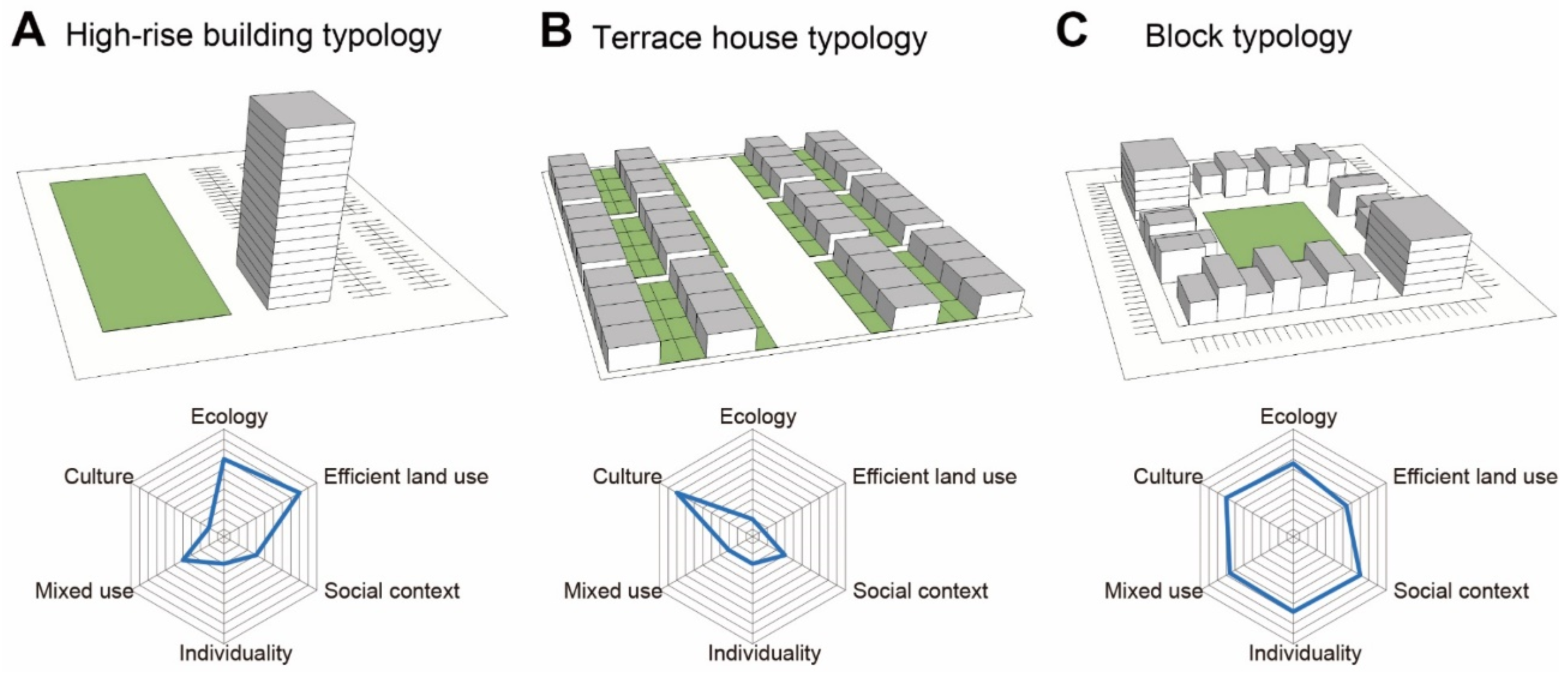
As previously mentioned, a sustainable neighborhood plan is based on high-density urban design quality. To ensure the quality of high-density urban design, detailed design scales for each item were established based on sustainability concepts from environmental, economic, and social perspectives, as described in Section 2.1. First, from an environmental perspective, there is a sustainable ecological system and measure of individuality derived from the urban form. Second, from an economic perspective, the criteria comprise efficiency of land use for the production and use of resources and diverse and mixed amenities. Third, from a social perspective, interest in neighboring communities, social context at the level of exchange, and urban culture created through the participation of residents become design criteria (Table 1). Based on these criteria, to measure the quality of urban design, three urban design models were selected as samples to derive a sustainable urban design for neighborhoods. Owing to the nature of the neighborhood plan, whose main purpose is residential space planning, each model had a certain number of residential units (60 units) as its main program and a certain amount of land (1 ha) as the subject of the plan. The first model is a high-rise building typology in which the program is concentrated in a single building with a small building area (Figure 1A). The second model is a terrace house typology, which has a low-rise private yard with numerous standardized buildings occupying a large amount of land (Figure 1B). The final model is a compromise between the first and second models and is a block typology in which various block-shaped buildings surround a large public space (Figure 1C). By applying the criteria to measure the quality of the urban design to these three urban design models, it was concluded that the block typology was the optimal sustainable neighborhood model.
4. Case Study Design
4.1. Selection of the Site
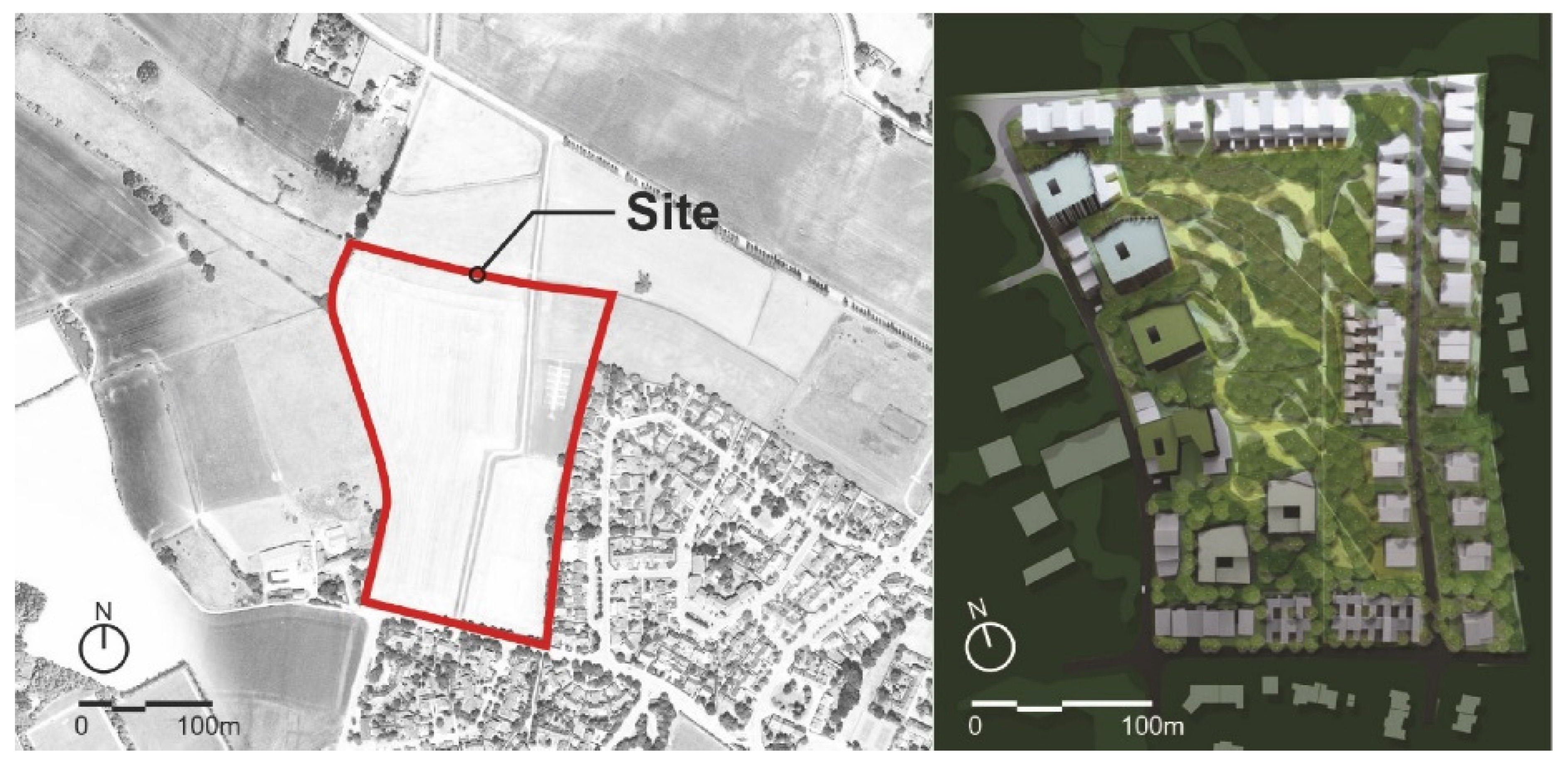
The subject of this study was an area called Trémelière, which belongs to the commune of Le Rheu, located in northwestern France. Currently, Le Rheu’s administrative area covers 1900 ha. Le Rheu, a village with 900 residents in the 1950s, has 9225 residents as of 2021 [51]. In the history of French urban planning, Le Rheu has the characteristic of being created for urban planning as a “garden city” in the mid-20th century [52]. In the early 1950s, the automobile company Citroën factory opened in Rennes, a large city adjacent to Le Rheu, and urbanization began for the first time in 1955 to provide single-family housing for automobile workers. Subsequently, as the number of workers increased, Le Rheu underwent full-fledged urban planning to accommodate workers. The first official urban planning of Le Rheu was initiated by urban planner Gaston Bardet in 1957 [53]. Gaston Bardet defined urban planning as “the degree of effort to form the true soul of the city” and believed that the soul of the city for Le Rheu should be built from the already existing natural environment [54]. Gaston Bardet conducted original and experimental urban planning for Le Rheu for more than 10 years, starting in 1957. Le Rheu’s urban planning refers to the process of integrating a new residential space for humans with nature. The preservation of external spaces and landscaping are prerequisites for urban planning. Currently, Le Rheu is being planned based on Gaston Bardet’s Garden City urban plan. Consequently, all sites within Le Rheu are subject to urban planning laws that require a minimum amount of greenspace to be secured during urban development [55].
This study selected the 5.2 ha area of Trémelière in Le Rheu Commune, which has an important urban planning history from the perspective of France’s garden city, as the research subject. The main purpose of the site was to plan residential spaces for 234 households. The specific urban regulations that apply to this site include securing a minimum greenspace ratio of 30% and a building-to-land ratio of less than 30%, which are the most important elements of Le Rheu’s urban planning [56]. The urban planning regulations applied to this site indicate that the garden city urban planning concept remains the basis of urban space planning in Le Rheu.
4.2. Block Typology Design
The neighborhood design of the Trémelière site is based on block typology, and the optimal model for a sustainable neighborhood derived from the design methodology is described in Section 3 (Figure 2, right). The neighborhood design concept encompasses several key aspects. First, from an environmental perspective, residential buildings surround a large green space at the center of the site. The 5.2 ha site is characterized by the fact that the entire site is grassland (Figure 2, left). Conditions adjacent to the target site were divided into two categories. The southern and eastern boundaries of the site are bordered by typical single-family residential areas with private front yards, whereas the northern and western sides are connected by large grasslands. Second, a compact building design focusing on economic aspects was proposed. Consequently, the building-to-land ratio was lowered, securing more outdoor spaces. A tower-shaped complex located on the western side of the site was planned to accommodate residential and commercial facilities and parking spaces for efficient land use. Third, from a social perspective, various levels of vertical green spaces were proposed, using large green spaces in the center and parking rooftops in the west. These various levels of green space are the result of a plan to reinterpret and inherit the garden city concept, which is at the core of Le Rheu’s urban planning, into the 21st century. Simultaneously, it satisfied the greenspace ratio stipulated by urban regulations.
4.2.1. Housing Units
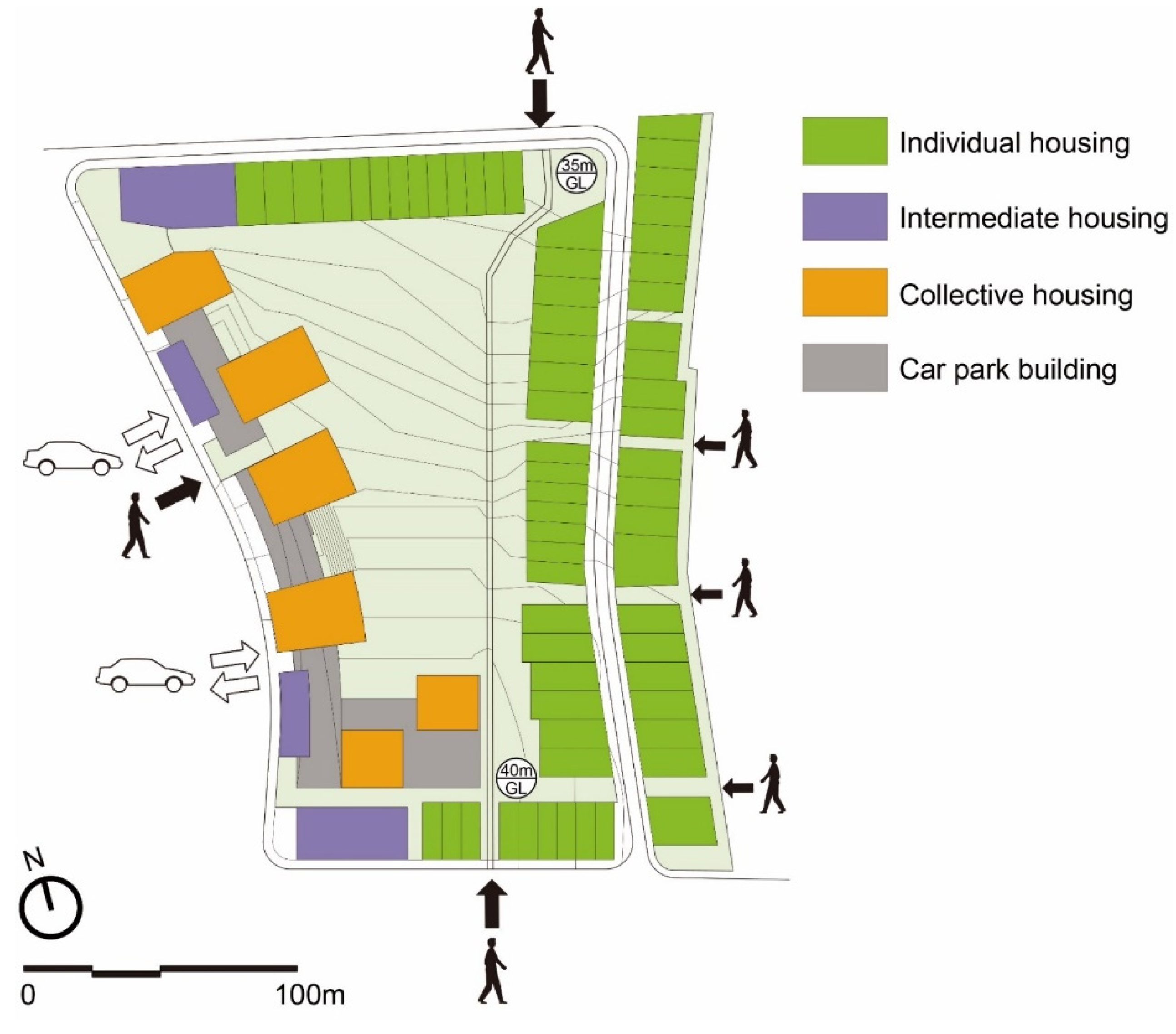
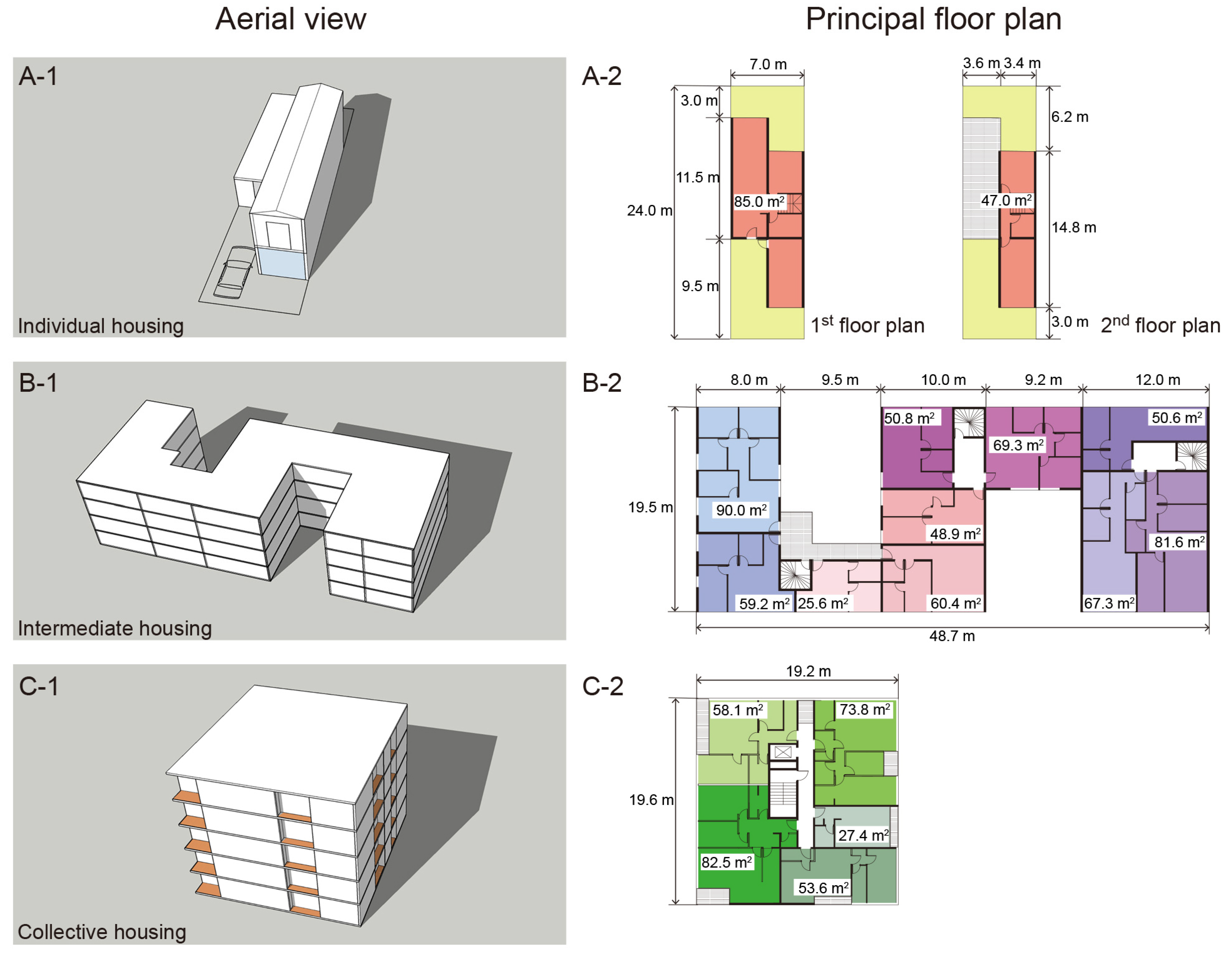
Residential units within the site were divided into three types: individual, intermediate, and collective. A two-story parking building was planned at the bottom of the collective housing unit to secure a large parking space (Figure 3).
The individual housing unit was a two-story building with 64 units (Figure 4(A-1)). Individual housing units were located at the southern, eastern, and northern boundaries of the study site. Individual housing located south and east of the site is connected to the urban form of individual housing that exists south and east of the site. On the northern side of the site, individual housing units in the form of low buildings were placed to enable viewing from the large green public space inside the site to the wide plain on the northern edge. In addition, low-height individual housing buildings located in the north provided sufficient lighting and ventilation at the site.
The individual housing unit was designed as a basic module with a land size of 7 m width and 24 m length. The individual housing unit has a total living area of 132 m2, comprising 85.0 m2 on the first floor and 47.0 m2 on the second floor. This narrow and long land area was divided into various external spaces for single-family residences. External spaces were placed on the first floor at both ends of the building. The exterior space at the entrance to the residence was used as an extra parking space in addition to the garage for parking, and the exterior space on the other side of the driveway was planned as a private garden. The external space on the second floor was a large terrace that used the rooftop of the building on the first floor. The three-dimensional external space on the first and second floors was created as a green space by the residents and was planned to expand the garden city concept, which is the basis of Le Rheu’s traditional urban design (Figure 4(A-2)).
Four intermediate houses, up to four stories high, were planned at both ends and in the middle of the western side of the site (Figure 4(B-1)). The first floor of the building is a piloti-style parking lot, and the three floors from the second through fourth floors are residential spaces. The intermediate housing in the four buildings accommodated 40 households, and 10 units of different residential areas were placed on the standard floor of the building. The residential areas are 25.6 m2, 48.9 m2, 50.6 m2, 50.8 m2, 59.2 m2, 60.4 m2, 67.3 m2, 69.3 m2, 81.6 m2, and 90.0 m2 (Figure 4(B-2)). Intermediate housing, comprising various residential units ranging from the smallest area of 25.6 m2 to the largest area of 90.0 m2, is a type of housing designed to allow various classes to coexist in one building and encourage social exchange between classes.
Third, six collective housing units of up to five stories high were planned on the western boundary of the site (Figure 4(C-1)). Collective housing was planned for 130 units in six buildings. Collective housing is a tower-type residential building with an elevator and stairs located in the center of the building, and five different residential units are arranged around the core (Figure 4(C-2)). On the principal floor of the building, five types of residential units were placed, ranging from the smallest area of 27.4 m2 to the largest area of 82.5 m2. This floor plan was based on the same concept as the intermediate housing floor plan, and the residential community was naturally strengthened by the coexistence of various households in the building. Collective housing with an elevator located at the center of the building can secure more residential space through vertical expansion in the future.
Intermediate housing and collective housing are connected to a large parking lot on the ground floor located on the western border. This arrangement accommodates a large number of on-site residences, providing various residential spaces differentiated from low-height individual housing.
4.2.2. Parking-Oriented Infrastructure Linked to Collective Housing
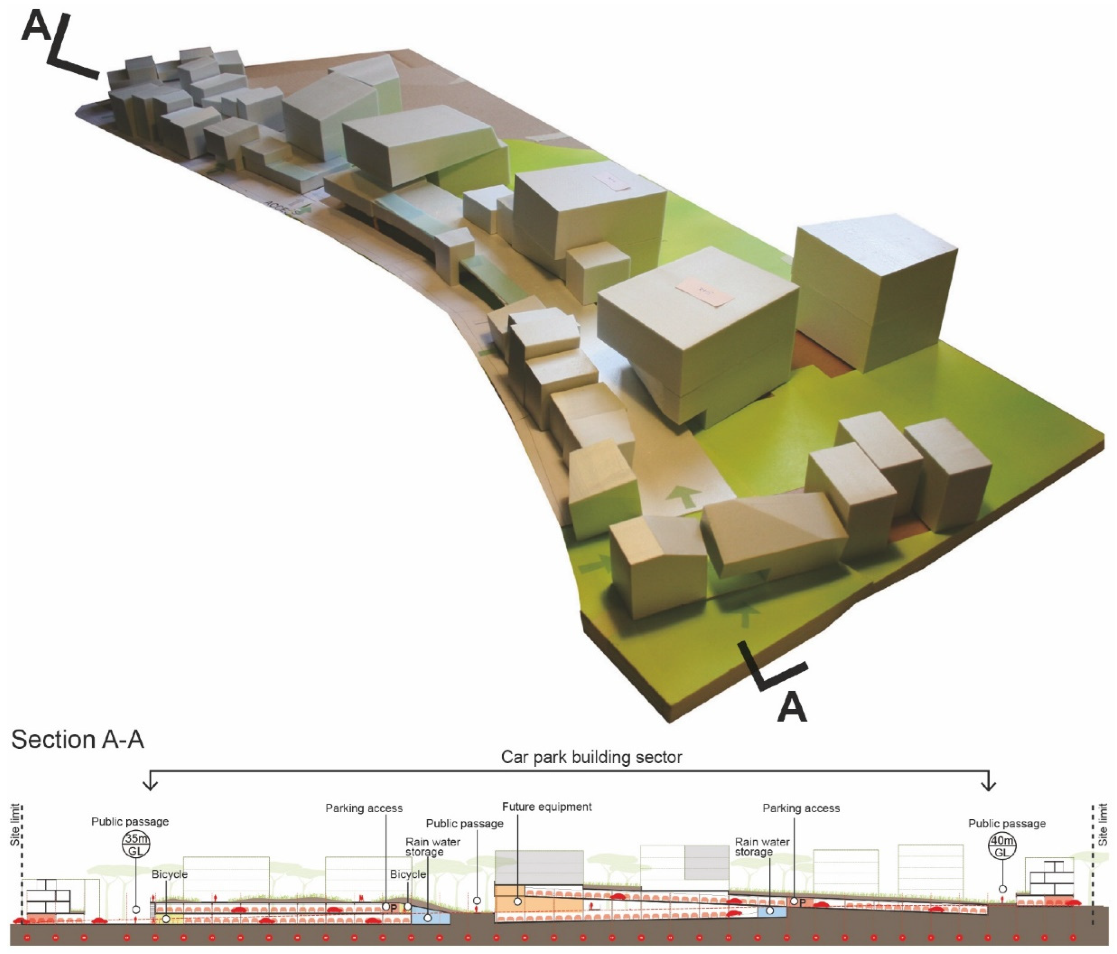
Based on the parking lot regulations applied at this site, a minimum of two spaces must be secured for individual housing units and 1.5 spaces per household for collective housing units [57]. The overall parking plan for this study site was designed to emphasize the green space of the entire site without exposing the parking space to the outside environment. For individual and intermediate housing units, a parking lot was planned on the ground floor of the lower part of the building using a pilot structure. However, the parking space for collective housing on the west side was planned to be a car park adjacent to the entire site boundary. The car park building is 16.5 m on the short side and 237 m on the long side. The entire building gently slopes from south to north of the site (Figure 5, top). Compared with underground parking lots, a car park building on the ground floor has the advantage of reducing construction costs and requires fewer facilities because of its natural ventilation.
In addition to parking spaces, various other amenities have been planned inside car-parked buildings. First, a bicycle parking lot was planned. Bicycles serve both as village transportation for residents and as an eco-friendly mode of transport, reinforcing the garden city character of the site. Second, rainwater storage was planned. Rainwater storage promotes the recycling of natural resources to maintain green spaces inside villages. Third, space for future equipment was created. The future equipment space is currently used as a parking space; however, it is planned to accommodate the amenities required in the village in the future (Figure 5, bottom).
4.2.3. Planning Various Public Spaces Using Parking Infrastructure
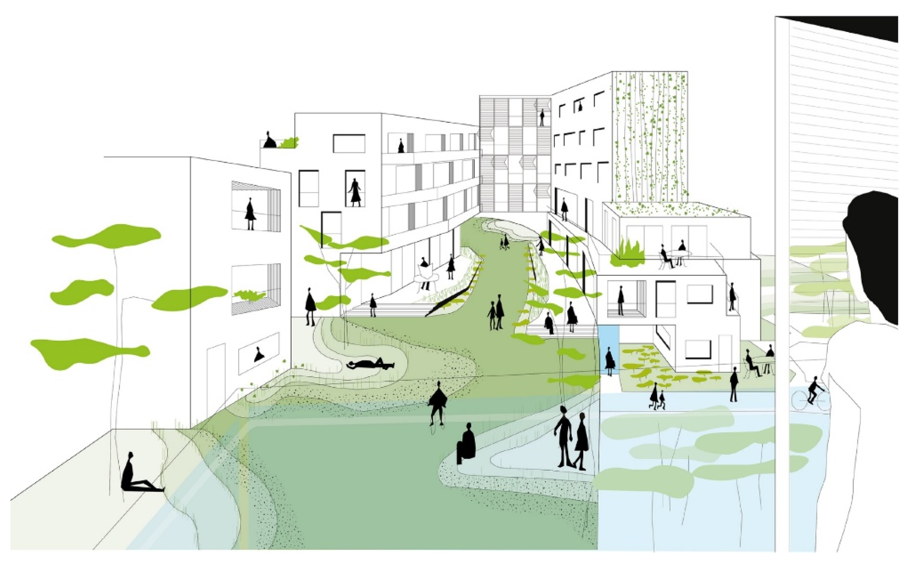
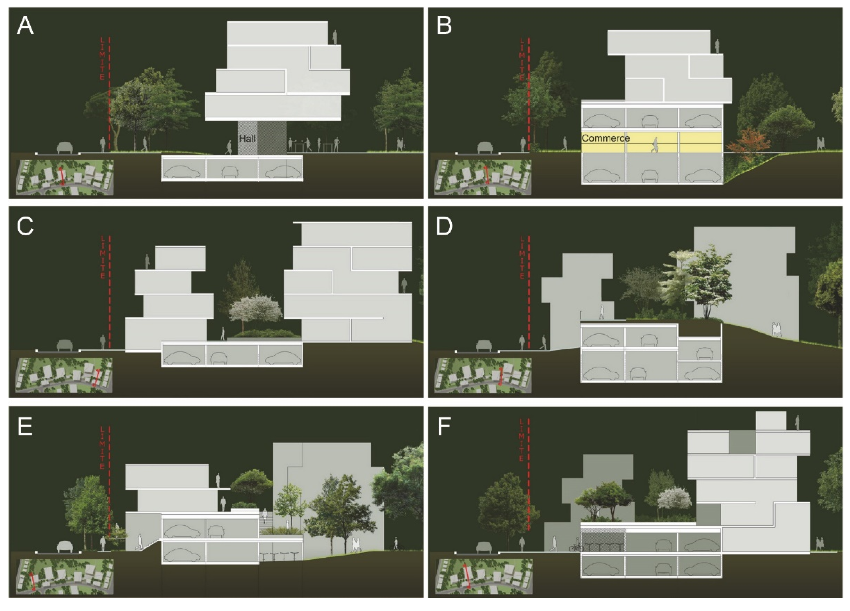
First, from a program perspective, the roof of the car park building, located on the western border of the site, was used as a green public space for residents (Figure 6). Second, from an architectural design perspective, an entire building is characterized by an inclined shape. Consequently, a height difference occurred between the car park building and the surrounding land, and various public spaces for residents in each section of the building were identified using this height difference. First, a public space for residents was planned using a parking lot pilot structure with a hall or sports facility (Figure 7A) and small commercial facilities (Figure 7B). Second, green spaces were created using roofs. A semi-public garden exclusively for collective housing residents (Figure 7C) and a garden-like public green space that connects the height difference between the ground and the car park building was created (Figure 7D). Third, accessibility from the ground to the car park building was diversified by taking advantage of the fact that the location of the parking lot for each section of the car park building differed depending on the level of surrounding land (Figure 7E). Bicycle storage was installed in the parking lot space with good accessibility (Figure 7F). Bicycle storage connected to parking lots encourages residents to use bicycles. Implementing vertical public gardens on car park rooftops and promoting bicycles as eco-friendly modes of transportation in villages will further strengthen the nature of garden cities, which is Le Rheu’s most important urban planning philosophy.
5. Results and Discussion
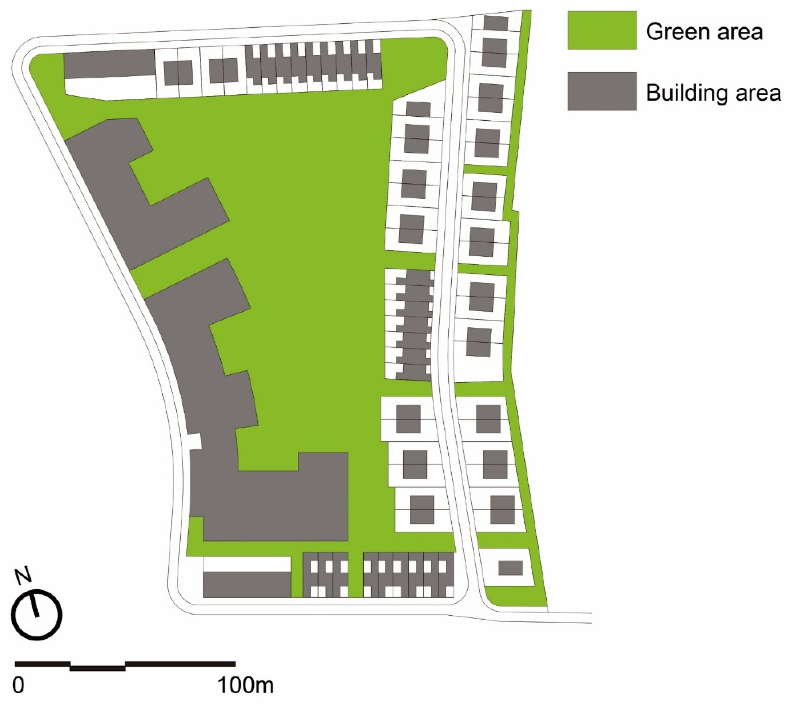
This study implemented a neighborhood plan to accommodate 234 households in the form of individual, intermediate, and collective housing at the Trémelière site in Le Rheu Commune. The main objective of the neighborhood design was to secure as much green space as possible at the center of the site to preserve the historicity of the Garden City—which was the basis of Le Rheu Commune’s urban planning—and to realize ecologically sustainable urban planning. Consequently, the total site area of 52,000 m2 was divided into a green area of 20,570.8 m2 and a building area of 13,955.3 m2 (Figure 8). The distribution of green and building areas indicated that the green area ratio within the site was 39.6%, and the building-to-land ratio was 26.8%. This result satisfied the urban planning regulations applied to this site, including securing a greenspace ratio of at least 30% and a building-to-land ratio of less than 30%.
From a residential architectural planning perspective, this neighborhood was characterized by intermediate and collective housing located on the west side of the site. Collective housing was connected to a two-story car park building on the ground floor, which was planned to create a vertical and three-dimensional common space for residents, beyond simply securing multiple parking spaces for collective housing units. The interior of a car park provided variable space to accommodate bicycle storage and other amenities needed by future residents. In addition, the rooftop of the car park building was created as a public garden to revitalize the residents’ community. This vertical green space was a new type of green public space that differed from ground-floor green spaces. Vertical green spaces further expanded Le Rheu’s garden city urban planning concept by providing additional aerial green spaces at the site.
The parking infrastructure proposed in this study had the potential to become a public space for residents. Specifically, it had the potential to become a technology-intensive infrastructure that uses the scale of the infrastructure and incorporated technologies for solar power generation, rainwater storage tanks, and automatic parking systems. Parking infrastructure could be combined with an automated system for renewable energy production and urban operations to strengthen the village’s self-reliance. Technology-based self-sufficient urban planning using urban infrastructure combined with a rich natural environment could become a new sustainable urban planning model in the future. The infrastructure design for a sustainable neighborhood, as proposed in this study, had limitations, as it did not propose integration or practical methods with currently available smart technologies. However, this study was novel in that it was an empirical study based on urban planning theory. This study derived a novel design methodology based on a theoretical analysis. The infrastructure-based urban planning developed by this study is a new model of sustainable urban planning for achieving the three pillars of sustainable urban planning (environmental, economic, and social). This theory-based empirical research model contributes to the academic aspects of urban planning theory and provides a new sustainable design model to urban planners and architects.
6. Conclusions
This study carried out a challenging urban planning project to design a neighborhood based on the ecological urban historicity of Le Rheu. This study proposes a different approach to urban planning compared to the one currently implemented in Trémelière. This study proposed infrastructure-based urban planning. The infrastructure-based urban planning proposed in this study is a new model of urban planning that can change and develop as needed even after the building of a city is completed.
Future research should expand sustainable neighborhood planning based on the ecological infrastructure attempted in Le Rheu Commune into urban planning research combined with the IoT, including smart home care. Currently, IoT-based smart cities are being developed for urban planning. However, smart cities tend to focus on innovative technology rather than nature or people. From this perspective, a smart city planned for the future should be a model in which innovative technologies for urban management are applied based on the premise of urban planning, which considers environmental preservation, human behavior, spatial planning, and various urban amenities, as conducted in this study. This is because the purpose of urban planning is to further develop human settlements; thus, human-centered urban planning, not technology-centered planning, must be pursued.
Funding
This study was supported by a National Research Foundation of Korea (NRF) grant funded by the Korean Government, Ministry of Science, and ICT (MSIT) (No. 2022R1F1A1065442).
Institutional Review Board Statement
Not applicable.
Informed Consent Statement
Not applicable.
Data Availability Statement
Data are contained within the article.
Conflicts of Interest
The author declares no potential conflicts of interest.
References
- Brundtland, G.H. Our common future—Call for action. Environ. Conserv. 1987, 14, 291–294. [Google Scholar] [CrossRef]
- Ho, S.S.; Kristiansen, S. Environmental debates over nuclear energy: Media, communication, and the public. Environ. Commun. 2019, 13, 431–439. [Google Scholar] [CrossRef]
- Kourtit, K.; Elmlund, P.; Nijkamp, P. The urban data deluge: Challenges for smart urban planning in the third data revolution. Int. J. Urban Sci. 2020, 24, 445–461. [Google Scholar] [CrossRef]
- Nakajima, T.; Ohara, T.; Uematsu, M.; Onda, Y. Environmental Contamination from the Fukushima Nuclear Disaster: Dispersion, Monitoring, Mitigation and Lessons Learned; Cambridge University Press: Cambridge, UK, 2019; pp. 5–9. [Google Scholar]
- Marchese, D.; Reynolds, E.; Bates, M.E.; Morgan, H.; Clark, S.S.; Linkov, I. Resilience and sustainability: Similarities and differences in environmental management applications. Sci. Total Environ. 2018, 613–614, 1275–1283. [Google Scholar] [CrossRef]
- United Nations. Available online: https://treaties.un.org/Pages/ViewDetails.aspx?src=TREATY&mtdsg_no=XXVII-7-d&chapter=27&clang=_en (accessed on 5 June 2023).
- European Commission. Available online: https://op.europa.eu/en/publication-detail/-/publication/97d6a4ca-5847-11ea-8b81-01aa75ed71a1/language-en/format-PDF/source-119528141 (accessed on 10 August 2023).
- Ministry of Trade, Industry and Energy. Available online: http://english.motie.go.kr/en/tp/energy/bbs/bbsView.do?bbs_seq_n=605&bbs_cd_n=2&view_type_v=TOPIC¤tPage=1&search_key_n=&search_val_v=&cate_n=3 (accessed on 20 August 2023).
- Wolsink, M. Near-shore wind power—Protected seascapes, environmentalists’ attitudes, and the technocratic planning perspective. Land Use Policy 2010, 27, 195–203. [Google Scholar] [CrossRef]
- Jeong, M.; You, J.S. Estimating the economic costs of nuclear power plant outages in a regulated market using a latent factor model. Renew. Sustain. Energy Rev. 2022, 166, 112582. [Google Scholar] [CrossRef]
- Malischek, R.; Trüby, J. The future of nuclear power in France: An analysis of the costs of phasing-out. Energy 2016, 116, 908–921. [Google Scholar] [CrossRef]
- McHarg, I.L. Design with Nature; Natural History Press: Cheltenham, UK, 1969; p. 48. [Google Scholar]
- Baek, S.M. Ecosystème Urbain et Architecture en Asie Orientale; Editions L’Harmattan: Paris, France, 2021; pp. 20–25. [Google Scholar]
- Cialdea, D.; Pompei, C. The Waterfront Development in Europe: Between Planning and Urban Design Sustainability. In Innovating Strategies and Solutions for Urban Performance and Regeneration; Springer: Berlin, Germany, 2022; pp. 49–60. [Google Scholar]
- Macdonald, E. Urban Design for Sustainable and Livable Communities: The Case of Vancouver. In Transportation, Land Use, and Environmental Planning; Elsevier: Amsterdam, The Netherlands, 2020; pp. 83–104. [Google Scholar]
- Minke, G. Building with Bamboo: Design and Technology of a Sustainable Architecture; Birkhäuser: Basel, Switzerland, 2022; pp. 24–29. [Google Scholar]
- Salama, S.W. Towards developing sustainable design standards for waterfront open spaces. City Territ. Archit. 2022, 9, 26. [Google Scholar] [CrossRef]
- Schröpfer, T. Dense+Green: Innovative Building Types for Sustainable Urban Architecture; Birkhauser: Basel, Switzerland, 2016; pp. 144–155. [Google Scholar]
- Benevolo, L. The Origins of Modern Town Planning; Landry, J., Translator; Routledge & K. Paul: London, UK, 1967; p. 105. [Google Scholar]
- Ahad, M.A.; Paiva, S.; Tripathi, G.; Feroz, N. Enabling technologies and sustainable smart cities. Sustain. Cities Soc. 2020, 61, 102301. [Google Scholar] [CrossRef]
- Anthopoulos, L.G. Defining smart city architecture for sustainability. In Proceedings of the 14th Electronic Government and 7th Electronic Participation Conference (IFIP2015), Thessaloniki, Greece, 30 August 2015. [Google Scholar]
- Ahmad, K.; Maabreh, M.; Ghaly, M.; Khan, K.; Qadir, J.; Al-Fuqaha, A. Developing future human-centered smart cities: Critical analysis of smart city security, Data management, and Ethical challenges. Comput. Sci. Rev. 2022, 43, 100452. [Google Scholar] [CrossRef]
- Alshemerty, M.A.; Albasri, N.A.H. Smart neighborhood as a sustainable neighborhood: A comparative study of Al-Ghadeer village (Najaf-Iraq). IOP Conf. Ser. Earth Environ. Sci. 2023, 1129, 012019. [Google Scholar] [CrossRef]
- Rahman, N.A.; Pujiyanti, I. Principles of a healthy neighbourhood for sustainable development and social well-being: A review paper. Geogr.-Malays. J. Soc. Space 2023, 19, 46–60. [Google Scholar]
- Khavarian-Garmsir, A.R.; Sharifi, A.; Sadeghi, A. The 15-minute city: Urban planning and design efforts toward creating sustainable neighborhoods. Cities 2023, 132, 104101. [Google Scholar] [CrossRef]
- Chichilnisky, G.; Heal, G.; Vercelli, A. Sustainability: Dynamics and Uncertainty; Springer Science & Business Media: Berlin, Germany, 2012; pp. 144–155. [Google Scholar]
- Toli, A.M.; Murtagh, N. The concept of sustainability in smart city definitions. Front. Built Environ. 2020, 6, 77. [Google Scholar] [CrossRef]
- Kopfmüller, J. A Global Model–Universal and Contextual. In Theories of Sustainable Development; Routledge: London, UK, 2014; p. 112. [Google Scholar]
- Del Río, P.; Burguillo, M. Assessing the impact of renewable energy deployment on local sustainability: Towards a theoretical framework. Renew. Sustain. Energy Rev. 2008, 12, 1325–1344. [Google Scholar] [CrossRef]
- Mukherjee, I. Policy Design for Sustainable Energy and the Interplay of Procedural and Substantive Policy Instruments; Routledge Handbook of Environmental Policy; Routledge: London, UK, 2023; pp. 19–23. [Google Scholar]
- Sotirov, M.; Pokorny, B.; Kleinschmit, D.; Kanowski, P. International forest governance and policy: Institutional architecture and pathways of influence in global sustainability. Sustainability 2020, 12, 7010. [Google Scholar] [CrossRef]
- Wong, R. What makes a good coordinator for implementing the sustainable development goals? J. Clean. Prod. 2019, 238, 117928. [Google Scholar] [CrossRef]
- Campbell, S. Green cities, growing cities, just cities?: Urban planning and the contradictions of sustainable development. J. Am. Plan. Assoc. 1996, 62, 296–312. [Google Scholar] [CrossRef]
- Finkbeiner, M.; Schau, E.M.; Lehmann, A.; Traverso, M. Towards life cycle sustainability assessment. Sustainability 2010, 2, 3309–3322. [Google Scholar] [CrossRef]
- Kleine, A.; Von Hauff, M. Sustainability-driven implementation of corporate social responsibility: Application of the integrative sustainability triangle. J. Bus. Ethics 2009, 85, 517–533. [Google Scholar] [CrossRef]
- Purvis, B.; Mao, Y.; Robinson, D. Three pillars of sustainability: In search of conceptual origins. Sustain. Sci. 2019, 14, 681–695. [Google Scholar] [CrossRef]
- Choguill, C.L. Developing sustainable neighbourhoods. Habitat Int. 2008, 32, 41–48. [Google Scholar] [CrossRef]
- Mangut, B.; Ozsoy, F.A. Housing neighborhoods as an interaction of enclosure and disclosure. Archnet-IJAR Int. J. Archit. Res. 2020, 14, 45–59. [Google Scholar] [CrossRef]
- Schnur, O. Quartiersforschung im Überblick: Konzepte, Definitionen und aktuelle Perspektiven. In Quartiersforschung: Zwischen Theorie und Praxis; Springer: Berlin/Heidelberg, Germany, 2008; pp. 19–51. [Google Scholar]
- Jacobs, J. The Death and Life of Great American Cities; Vintage: London, UK, 2016; pp. 67–70. [Google Scholar]
- Choay, F. The Modern City: Planning in the 19th Century; George Braziller: New York, NY, USA, 1969; pp. 10–12. [Google Scholar]
- Bacon, E.N. Design of Cities: Revised Edition; Penguin Books: London, UK, 1976; pp. 85–87. [Google Scholar]
- Cottineau, C.; Pumain, D. Cities at the Heart of Inequalities; Wiley: Hoboken, NJ, USA, 2022; pp. 1–44. [Google Scholar]
- Alexander, C. Towards a sustainable neighborhood: The role of open spaces. Archit. Res. 2008, 2, 162–177. [Google Scholar]
- Lynch, K. The Image of the City; MIT Press: Cambridge, UK, 1964; pp. 75–76. [Google Scholar]
- Dave, S. High urban densities in developing countries: A sustainable solution? Built Environ. 2010, 36, 9–27. [Google Scholar] [CrossRef]
- Jamei, E.; Ahmadi, K.; Chau, H.W.; Seyedmahmoudian, M.; Horan, B.; Stojcevski, A. Urban design and walkability: Lessons learnt from Iranian traditional cities. Sustainability 2021, 13, 5731. [Google Scholar] [CrossRef]
- Moroke, T.; Schoeman, C.; Schoeman, I. Developing a neighbourhood sustainability assessment model: An approach to sustainable urban development. Sustain. Cities Soc. 2019, 48, 101433. [Google Scholar] [CrossRef]
- Pafka, E. Multi-scalar urban densities: From the metropolitan to the street level. Urban Des. Int. 2020, 27, 53–63. [Google Scholar] [CrossRef]
- Bott, H.; Grassl, G.; Anders, S. Sustainable Urban Planning: Vibrant Neighbourhoods–Smart Cities–Resilience; Edition Detail: Munich, Germany, 2019; pp. 40–44. [Google Scholar]
- Mairie de Le Rheu. Available online: https://www.lerheu.fr/ma-ville/presentation/presentation-de-la-ville/ (accessed on 3 August 2023).
- Luginbühl, Y.; Howard, P. Landscape and Sustainable Development: The French Perspective; Routledge: London, UK, 2016; pp. 52–55. [Google Scholar]
- Allain, R. Le Rheu, 1953–2003: L’utopie à l’épreuve. Les 50 ans d’une “villette”, cité-jardin de la région rennaise. Cah. Nantais 2002, 58, 209–222. [Google Scholar] [CrossRef]
- Bardet, G. L’Urbanisme; Presses Universitaires de France: Paris, France, 1964; pp. 12–13. [Google Scholar]
- Mairie de Le Rheu. Available online: https://www.lerheu.fr/wp-content/uploads/2022/09/1.2_note-de-presentation-generale.pdf (accessed on 10 August 2023).
- Rennes Métropole. Available online: https://metropole.rennes.fr/consulter-les-documents-du-plan-local-durbanisme-intercommunal-plui (accessed on 15 August 2023).
- Département d’Ille-et-Vilaine and Rennes Métropole. Available online: https://www.registres-dematerialises.fr/report/3043/download/final_report (accessed on 3 September 2023).
Figure 1.
Three typologies of urban design (source: reconstructed by the author based on Bott et al., 2019 [50]).
Figure 1.
Three typologies of urban design (source: reconstructed by the author based on Bott et al., 2019 [50]).

Figure 2.
Trémelière site, 5.2 ha (left), proposition of block typology design (right) (source: designed by the author).
Figure 2.
Trémelière site, 5.2 ha (left), proposition of block typology design (right) (source: designed by the author).

Figure 3.
Distribution of types of housing units (source: designed by the author).

Figure 4.
Three types of housing units. Aerial view and principal floor plan of each housing unit (source: designed by the author).
Figure 4.
Three types of housing units. Aerial view and principal floor plan of each housing unit (source: designed by the author).

Figure 5.
Partial study model of the car park building (top) and section A-A: longitudinal section of the car park building (bottom) (source: designed by the author).
Figure 5.
Partial study model of the car park building (top) and section A-A: longitudinal section of the car park building (bottom) (source: designed by the author).

Figure 6.
Image of a public space created on the car park building’s roof (source: designed by the author).
Figure 6.
Image of a public space created on the car park building’s roof (source: designed by the author).

Figure 7.
Cross-sections of each of the car park building’s sectors. Organic connectivity between parking infrastructure and the surrounding natural environment (source: designed by the author).
Figure 7.
Cross-sections of each of the car park building’s sectors. Organic connectivity between parking infrastructure and the surrounding natural environment (source: designed by the author).

Figure 8.
Distribution of green and building areas (source: designed by the author).


Table 1.
Framework for sustainable neighborhood planning.
| Objective | Criteria | Detailed Measurement Items |
|---|---|---|
| Environmental | Ecology Individuality | Eco-system and urban biodiversity Urban form and urban morphology |
| Economic | Efficient land use Mixed use | Floor area ratio and building-to-land ratio Amenities |
| Social | Social context Culture | Human exchange and social networks Participation |
Disclaimer/Publisher’s Note: The statements, opinions and data contained in all publications are solely those of the individual author(s) and contributor(s) and not of MDPI and/or the editor(s). MDPI and/or the editor(s) disclaim responsibility for any injury to people or property resulting from any ideas, methods, instructions or products referred to in the content. |
© 2024 by the author. Licensee MDPI, Basel, Switzerland. This article is an open access article distributed under the terms and conditions of the Creative Commons Attribution (CC BY) license (https://creativecommons.org/licenses/by/4.0/).
Share and Cite
MDPI and ACS Style
Choi, H.-S. Reinventing Sustainable Neighborhood Planning: A Case Study of Le Rheu, France. Buildings 2024, 14, 536. https://doi.org/10.3390/buildings14020536
AMA Style
Choi H-S. Reinventing Sustainable Neighborhood Planning: A Case Study of Le Rheu, France. Buildings. 2024; 14(2):536. https://doi.org/10.3390/buildings14020536
Chicago/Turabian StyleChoi, Ho-Soon. 2024. "Reinventing Sustainable Neighborhood Planning: A Case Study of Le Rheu, France" Buildings 14, no. 2: 536. https://doi.org/10.3390/buildings14020536
Note that from the first issue of 2016, this journal uses article numbers instead of page numbers. See further details here.