Article

Building Interventions in Mediterranean Towns—Developing a Framework for Selecting the Optimal Spatial Organization and Construction Technology from a Sustainable Development Perspective

Faculty of Civil Engineering, University of Rijeka, 51000 Rijeka, Croatia
*
Authors to whom correspondence should be addressed.
Buildings 2022, 12(8), 1233; https://doi.org/10.3390/buildings12081233
Submission received: 2 August 2022 / Revised: 10 August 2022 / Accepted: 11 August 2022 / Published: 13 August 2022

Abstract

:
Mediterranean towns and their surroundings show specific characteristics, such as urban structure, presence of complex stratification of heritage, and often seasonality, which makes the choice of spatial organization and construction technology for building construction of high importance in relation to sustainable development. For such purpose, the SOnCT model, based on multi-criteria decision analysis, has been developed which takes into account optimal building interventions in Mediterranean towns from a sustainable development perspective, highlighting their spatial-technical aspects. The presented research answers the questions of how sustainable development goals can be implemented in the case of construction interventions in Mediterranean areas, especially in smaller settlements that present very fragile status and specific characteristics not comparable to northern towns. This paper presents the construction and verification of the evaluation and prioritization model for selecting the optimal spatial organization and construction technology based on the criteria of sustainability, spatial characteristics, and the United Nations’ Sustainable development goals.

1. Introduction

Mediterranean towns and their surroundings present various characteristics specific to the area that regard spatial, social, and cultural characteristics. Often, the settlements present a very complex stratification of heritage and urban structure that makes it difficult to intervene without impacting physical characteristics, daily life, economic activities, or even surrounding territory and infrastructure. Frequently used designs, spatial, construction proposals, spatial organization, and construction technology can have a high impact on spatial functioning, blocking economic activities, physical communication, daily social and cultural activities, and access to public closed and open spaces as well as on the characteristics of built structures or green areas, even exacerbating the extreme character of the climate. The Mediterranean identity acquires ever more importance with the formation of supranational unions such as the European Union [1]. Mediterranean areas, besides having a very long and rich history, are also a major touristic area in the world [2] and a constant inspiration for culture and arts.
Therefore, the need arises to understand how to approach construction interventions in organizational—spatial and temporal terms, and choice of technology. These aspects are highly influenced by the characteristics of Mediterranean settlements and can be important for the achievement of the United Nation’s Sustainable development goals (UN SDGs) that are a part of the United Nations’ Agenda 2030 [3]; therefore, it would be highly useful to allow for evaluation of the UN SDGs fulfillment in construction processes, for example, in public procurement and choice of spatial organization and construction technology for proposed spatial intervention. Such an evaluation and prioritization model could aid in building work organization—in terms of spatial organization and choice of technology, which would respect the spatial, social, and cultural characteristics of Mediterranean settlements in the sustainable development perspective that is considered in the UN SDGs. This would provide not just the opportunity to establish broad sets of criteria based upon the UN SDGs for building intervention, but also similar sets of criteria that would be appropriate for assessments in other Mediterranean areas.
All the aforementioned implies the need for using a multi-criteria decision analysis (MCDA) approach or at least using one or several multi-criteria methods throughout the decision-making process. Various researchers [4,5,6,7,8,9,10] have proposed different MCDA approaches based on the number of criteria and their type (qualitative or quantitative), but the most used methods are AHP [4,6,11,12,13], PROMETHEE [14,15,16,17], and their operational synergies [18], as well as approaches that manage stakeholders at the same time such as multi-actor multi-criteria analysis methodology, i.e., MAMCA [8,19], or decision support concept, i.e., DSC [20,21,22,23].
Therefore, this research aimed to create a framework for selecting an optimal spatial organization and construction technology, based on an MCDA approach, from a sustainable development perspective considering the spatial characteristics and specificities of Mediterranean areas. Based on the above, the hypothesis is stated as follows: “It is possible to determine how to approach the realization of construction intervention in a small Mediterranean town, based on the UN SDGs, using an evaluation and prioritization model.” For this, some research questions were asked:
What are the sustainable development goals for Mediterranean area settlements? What spatial characteristics and sustainable development goals of Mediterranean settlements can impact or be impacted by the choice of intervention technology and organization? How can we choose the optimal construction intervention technology and organization based on sustainable development and the UN SDGs for Mediterranean settlement?
The model was verified in a case study of a spatial intervention in the historic center of Kastav, Croatia, a small municipality that embeds many of the typical characteristics of Mediterranean settlements (further described in more detail).

2. Spatial Characteristics of Mediterranean Areas

2.1. Characteristics of Mediterranean Areas That Differ in Spatial Planning with Respect to Northern Urban Areas of the European Union and North America

Settlements in the Mediterranean area present some common characteristics—diversity of cultural heritage, stratification, and some challenges [24]. In particular, various authors indicate some common characteristics of the Mediterranean area that differ from northern and western areas [25,26]. In particular, these include spatial, social, and institutional characteristics, as well as characteristics of built and natural areas.
Some authors relate to the gaps in institutions [27]. Institutional characteristics relate to a different type of governance and weak planning. Social characteristics (related to institutional) are weaker social and demographic aspects, as well as instability. Spatial characteristics are particularly related to the presence of natural and cultural heritage, ecological fragility, as well as to processes of peri-urbanization [26] or “rurban” zones [28].
Today, the development of Mediterranean areas is seen as being different from those of northern and western areas (such as Northern Europe and the USA), where the development processes cannot be explained and analyzed with the same urban and regional development models as in northern countries [26,27,29,30].
The Mediterranean regions today are described as networks with a series of nodes, where the polycentric models are becoming more prevalent with the less defined areas of urban and peri-urban land, fringe areas, or territorial fractures [26,30,31,32]. Mediterranean cities often create a network of smaller cities within their peri-urban territory, which is economically more significant than the bigger city, resulting in the possibility of experiencing two typical effects due to the vicinity of bigger cities (aggregation effect and shadow effect) [27]. According to [33], modern planning often considers cities as “winners” and “losers” and this perspective is even reflected in some official documents on the development of the Mediterranean area that have strong northern-centric positions that view the Mediterranean as a periphery.
Although a positive trait of modern tradition is the protection of city centers, since the Athens Charter [34], the modern tradition of planning [35,36] introduces morphologies and functions different from Mediterranean traditions (with a rare exception of Plečnik’s Ljubljana plan from 1912) [29,37,38]. The introduction of new forms creates a fracture with the traditional spatial organization in spatial and mental terms and introduces frequent demolitions of existing spaces and their reconstruction in modernist ideas [37].
In fact, ref. [1] considers the “space” as a physical and mental category typical of the postmodern category or interest, in contrast to modernism which avoids concepts of contextualization or regionalism, although some authors indicate the attempt to combine modernistic and postmodern approaches [39].
Although modernism was greatly inspired by the Mediterranean urban structure and expressed its importance by choosing Mediterranean cities as the site of CIAM (Athens, Marseilles, and Dubrovnik), praising its dense structure (with simple forms of single buildings [33]), it did not appropriate the human scale of the Mediterranean environments, where walking and slow movement are the bases of spatial experience, reflection, and communication [40]. In fact, the Mediterranean area presents complex spaces where the modernist simplistic zoning approach does not give very positive results [33]. It is probably due to the apparent simplicity of modernist planning that alternate planning systems or combinations [41] are generally not used. A generative planning process based on traditional and contemporary principles and legislation could be a better alternative for the planning of historic settlements [42], especially in Mediterranean urban areas that have a long tradition of adaptive spatial interventions [43].
It is important to notice that in the traditional approach to interventions in Mediterranean areas, the definition of roles and obligations, as well as control and management, was the basic and continuous part of the planning system [42]. The same goes for semi-dense continuous settlements [44] and the protection of natural environments.
The evolution of cities from a sustainable development perspective requires models, decision aid processes, and tools for investments [45], especially in the presence of high Cultural Built Heritage (CBH) [46,47,48] and its importance in the landscape [49]; however, this crisis, in particular, created pressures for investments [50] which can be seen in the fast adaptation of Mediterranean cities to a sharing economy [51]. In fact, since the 1970s, the understanding is that decision-makers and the economy produce “land as a commodity” [51], and understanding the role of various stakeholders in relation to different sustainability goals is important [47,52].

2.2. Environment Built in Mediterranean Areas

In Mediterranean areas, rural areas are often transformed into urban and peri-urban areas, with a subsequent diminishing in natural resources. Illegal construction and erection of buildings are also characteristic of Mediterranean areas. In fact, some Mediterranean countries have a characteristic process of “legalization” of illegal constructions [53,54]. The peri-urban areas and fringe areas develop with the creation of sprawl and fractures, related to the fall of planning, and illegal construction but also the introduction to foreign modern planning models and Americanization of lifestyle [29].
The industry is transferred outside of the city. Mediterranean cities are characterized by “urbanization without industrialization” [53] and also the fact that phases of urbanization and industrialization are not often connected [27]. As a result, the spatial development of smaller and bigger Mediterranean cities can be very different [55].
The bigger cities have a problem with the population leaving the cities and the sprawl generated from the cities. This creates a problem that sprawl from bigger urban areas creates pressure on the smaller historic cities in the vicinity, such as in the case study situation. Sprawl is determined by inefficient land, infrastructure, and energy use, as well as low productivity [53] of labor. Investments and competition for investments have a low and negative impact on land use and the overall economy, in opposition to northern urban zones and models. Peri-urban areas also experience development due to the transfer of activities from centers to peri-urban areas and migration [53].
Another characteristic is the scattered development seen in peri-urban zones. Scattered peri-urban areas host most production, generally of smaller scale, and touristic activities, occupying important touristic areas, often separated from historic centers. User-oriented services are located in the centers, while the biggest and wealthiest activities, such as the financial and IT sectors, search for more economic land and tend to occupy peripheric positions [32]; this is then followed by an increase in roads and a decrease in green areas [56].
Due to changes related to development, Mediterranean areas face demographic, structural, and environmental challenges [57]. Up to the 1990s, Mediterranean areas had seen a population increase, followed by population stability or decrease. At the same time, it is often socially characterized by economic, social, and sometimes religious instability [26,30]. Some areas also face big challenges such as policy, security, economic, social, and environmental questions, as well as cultural and human rights [58].
The informal economy, low work costs, and over-use of resources are some of the characteristics of Mediterranean areas which are problematic because they hinder the development of a strong middle class [26,27,33].
The scattered pattern of settlements creates less energy-efficient interventions than the compactness of traditional cities. Even the Urban Heating Island effect in historic centers has more positive effects than in scattered areas. In winter, it helps with the heating of buildings and is mitigated in summer by smaller sun exposure surfaces [54].
Mediterranean areas are zones of ecological crisis, especially in rural areas. Scattered urban and peri-urban development creates great pressures on rural and natural land [53] (and the seaside, as in the case of many Mediterranean cities). Mediterranean cities show a decrease in biocapacity and an increase in ecological footprint [59]. In fact, [60] the UN 2030 Agenda highlights the importance of activities for the achievement of climate change resilience, resource sustainability, pollution and waste reduction, protection of biodiversity, ecosystems, and collaboration of Mediterranean countries. An analysis of the management plans of UNESCO-protected heritage sites (Venice, Krf, and Dubrovnik) shows, that there are some main challenges in common to the Mediterranean areas—intensive tourism, transportation, and gentrification (museification) [24].

2.3. Historic Urban Landscape (HUL) and Resilience

A long history, often pluri-millennial, of Mediterranean areas and their urban and rural development is greatly based on stratification and adaptation to climate [41], and tends to produce similar historic centers characteristic for all of the Mediterranean area.
The CBH is seen as particularly important due to tourism and local identity. On the other hand, tourism uses cultural and natural heritage [61], often with little investment in them, which creates great pressures on heritage [57] both in terms of use and adaptation, over-using spatial resources, and creating gentrification with the increase in real estate prices [62,63]. There is also the danger of adjusting the heritage to a touristic narrative [64]. The contemporary vision of development and new technologies also create expectations that CBH can be adapted easily [50,61] or that it cannot be included in spatial development. This is a problem because CBH cannot be replicated (because it was created based on different life [65] and technological conditions) and is a common heritage [47,66] that greatly considers the future [67], and, therefore, its Complex Social Value [68] is important, as well as its value as a social, cultural and economic resource.
The preservation of CBH can help with the creation of new jobs rooted in the local community, and the characteristics of CBH with aspects of common or even public good, independent of the property rights, shifts the focus from the physical aspects of CBH to the social aspects [69,70].
The loss of heritage can be traumatic for the local and international population [71] and lead to a loss of spatial identity [56]. This is particularly important as the extant historic areas tend to be in poor physical condition and have lower urban functionality [72].
Sustainability and resilience are important for the continuation of the human environment and human society. As robustness and redundancy are among the characteristics that allow for resilience, small historic centers are especially vulnerable to various pressures. As the spheres of resilience (infrastructure, institutions, economy, and society [73]) are all very fragile in Mediterranean cities, they require great attention in every intervention. The Mediterranean built environment, which is greatly different from modern spatial organizations, cannot be easily repeated and requires care during planning and interventions. In spatial terms, the scattering development greatly hinders resilience [32].
The Historic Urban Landscape (HUL) [69] approach, which continues active heritage preservation with considered heritage elements in a wider spatial perspective [72], is helped by decision-aid tools based on sustainable development goals and can increase rationality and transparency, especially in a complex spatial context, in areas with a stratification of heritage presence [74]. This process can be aided by multicriteria evaluations that reflect the multiplicity of values and goals [47,75].
Punctual project definition without proper attention to the effects the intervention can have during and after the construction phase is still the most common approach to intervention organization and technology choice. In the HUL environment, it can have even more impact due to the characteristics of CBH and the still prevalent bounding approach [75]. It is not possible to make interventions in HUL without taking into consideration the multiplicity of aspects of heritage and the possible impact the interventions, their organization, and choice of technology can have on the HUL characteristics.
In particular, ref. [69] indicates the importance of new tools for the sustainability of heritage transformation, as well as management, assessment, and participation, and highlights the planning element in heritage management. Furthermore, ref. [76] stresses the inadequate management plans as one of the major challenges of HUL management, as well as the need to include the local level. In a similar vein, some authors indicate the importance of documenting and analyzing the city based on historical facts and cartographic documentation, also in relation to its regional specificities and roles [77].
Small Mediterranean settlements often have different HUL categories [69], from monumental buildings to open urban spaces and infrastructure, that can be threatened, among other factors, by climate change. Especially characteristic are public spaces which are related to public life and freedom [78]. It is, therefore, strange that sustainability is mostly researched in economic aspects and less in environmental and social aspects [79]. Different elements of public infrastructure can impact the possibility and ease of use for persons with disabilities and mobility issues [80] and hinder their benefits from HUL [81].
On the other hand, studies of the HUL approach in different countries show that the weak links are public participation and lack of definition of the responsibilities for urban heritage management (lack of specific administration roles), and still tends to be mostly implemented and studied in Europe and China [82].

2.4. Urban Structure in Historic Centers in Mediterranean Areas

The climate impacted the traditional urban structure of Mediterranean settlements in great measure. One research example [29] shows that out of the distinctive Mediterranean characteristics, “urban structure” was the most defining element of the Mediterranean towns, followed by cultural identity and landscape, while social behavior resulted in the least common element. It was also found that of all the characterizing factors, the most endangered was the urban structure, which is worrying as it is also the element that produces the complexity of activities and relationships characteristic of Mediterranean towns. Especially important were events and food, while the importance of architecture depended on its quality.
Among spaces relevant to social life, public open spaces have a particular role, both as main squares and smaller spaces, based on pedestrian movement, detail, and the permeation of public and private spaces relevant to creating local identity [40,83]. Interestingly, historic towns in the Adriatic area often had more than 25% of their area designated to open public spaces together with different religious buildings [65].
In fact, although the character of Mediterranean towns is considered to be spontaneously created during history, and therefore somehow taken for granted, it is actually a result of a complex process of emergence based on a long history of codes, some of which (at least in written form) date back to Byzantine codes that dictated not plans but rules of spatial organization and processes and extended in all Mediterranean areas, even up to northern France [43]. Some of the main aspects are attention to avoiding damage to the extant, the definition of responsibilities, and the transition between private and public spaces. The regulatory aspect is also noticeable in Adriatic towns.
There are some characteristics related to “urban structure”, i.e., densely built condensed core (important for climate [84]), high buildings, narrow, usually labyrinth-like streets or a regular roman plan, with a small (but important) square and church (or other place of worship), with small but important green elements [29,40,85]. Some of the main characteristics of the urban structure are listed in Table 1.
Many Mediterranean towns experience great growth in population and tourism and sequent changes in social and spatial structure which makes it an important and difficult task to preserve the characteristics of these cities.

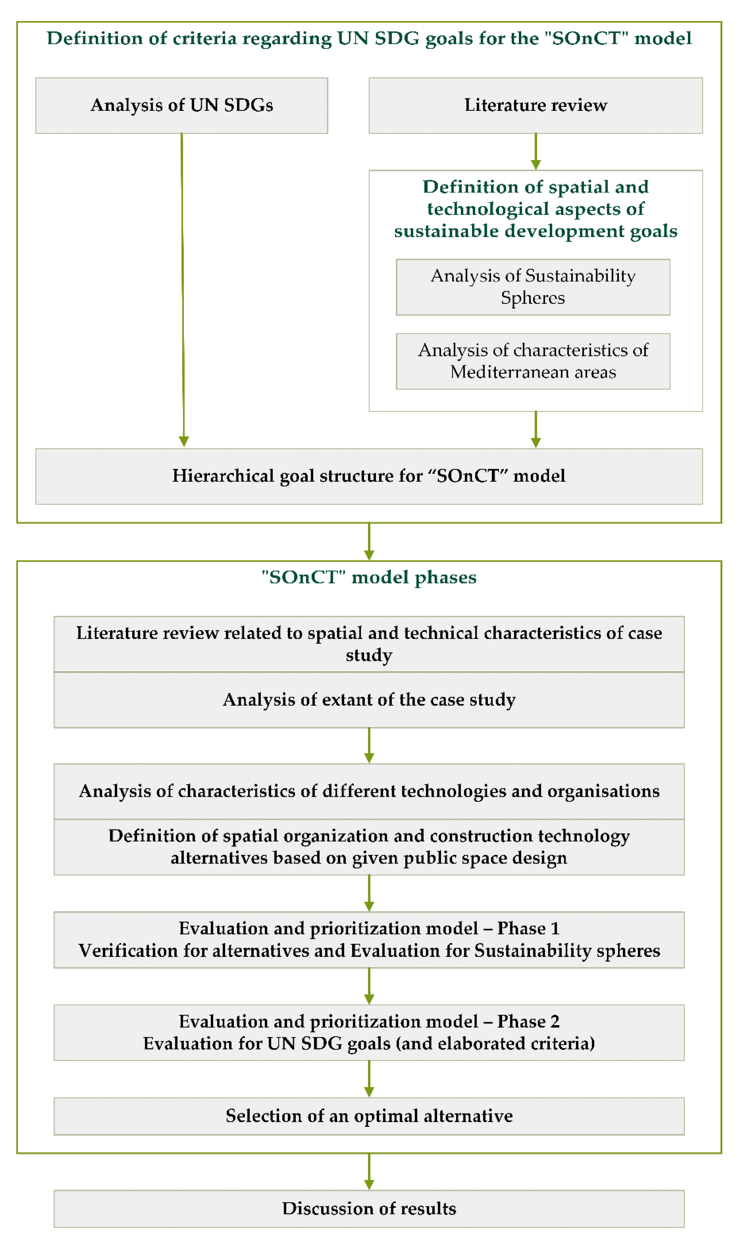
3. Materials and Methods

In order to address how the existing body of knowledge in civil engineering and urban planning has developed in the direction of building interventions, especially spatial organization and construction technology selection, a systematic analysis of the UN SDGs and systematic literature review were conducted in this study as well as direct correspondence and collaboration with experts. The conducted research (Figure 1) was performed in two essential stages, (i) the definition of criteria regarding the UN SDGs for the SOnCT model and (ii) the SOnCT model, closely followed by the discussion.
A systematic literature review was conducted for the purpose of defining the spatial and technological aspects of sustainable development goals with an emphasis on the analysis of sustainability spheres and the characteristics of Mediterranean areas and towns. The aforementioned resulted in the definition of very precise criteria for evaluation and prioritization of spatial organization and construction technology based on the UN SDGs that are defined in the hierarchical goal structure for the herein proposed SOnCT model (see Figure 2). The framework for selection of optimal spatial organization and construction technology from a sustainable development perspective (SOnCT model) consists of several steps, as shown in Figure 1, and follows 1, literature analysis, 2. analysis of the UN SDGs, 3. consultation with local experts in spatial planning and spatial management, 4. definition of criteria needed for an evaluation and prioritization model, 5. definition of organization and technology alternatives for the proposed spatial intervention, 6. creation of the evaluation and prioritization model, and 7. verification of the model compared to the proposed alternatives. The core of the proposed model is a multi-criteria decision analysis (MCDA) where different MCDA methods can be used to achieve the optimal solution to the problem.
Since the previously defined criteria can be both qualitative and/or quantitative, the SOnCT model uses the strengths of the PROMETHEE methods for steps six and seven. For this analysis, the VisualPROMETHEE software [86] was used which can give the results of the final ranking in both PROMETHEE II and PROMETHEE Diamond output. The major strength of PROMETHEE is that the method can cope with a large number of criteria, and their clusters, at the same time as well as clear insight into the final results by the decision-maker. On the other hand, the major weakness is the lack of the possibility to develop a hierarchical goal structure, and a need for an experienced decision analyst during phases one and two (Figure 2).
The literature analysis showed some major topics related to Mediterranean areas—from characteristics of historic urban structure to issues related to more recent development (such as scattering) to economic; especially touristic and social topics.
The analysis of the UN SDGs was done by filtering the goals that could be directly translated into criteria. Verifying the coverage of the issues related to the development of Mediterranean areas, it was seen as necessary to introduce an intermediate step—consultation with spatial planning experts that could define criteria related to the UN SDGs that reflected the Mediterranean area issues from the literature review and local conditions (Table 2 and Table 3). This produced additional criteria that could easily be considered as a development of some of the UN SDG goals (mostly Goal 11 but not only).
The expert in spatial planning and sustainable development also defined the main sustainability spheres and criteria that were later used for the verification of the minimum sustainability of alternatives in Phase 1 of the SOnCT evaluation and prioritization model.
Three organizational and technological alternatives of spatial intervention were defined and values for each criterion were assigned by construction organization and technology experts in consultation with experts in construction management and spatial planning. Those three alternatives were then evaluated, according to defined criteria, in Phase 2 of the SOnCT evaluation and prioritization model.
In the end, the research process and results are discussed and compared to similarly developed decision-aid tools that showed betterment in different urban areas and/or different management aspects in the same areas.
At the core of the proposed model is an opportunity to provide the decision-maker a tool to identify, evaluate, and analyze different alternatives before the decision and their implementation in real life. In our case, these alternatives are different construction technologies that need to be employed in order to support the construction process in Mediterranean areas and towns. Therefore, the main goal is defined as “selecting the optimal spatial organization and construction technology from a sustainable development perspective”. Such a goal is defined by a group of experts, as previously mentioned, and results from a systematic literature review and their expert view. The created hierarchical goal structure (Figure 2) consists of the main goal and 17 objectives, i.e., sub-goals defined as the UN SDGs and the following criteria (also see Table 4).
Such a clear goal hierarchy allows the decision-maker and other involved stakeholders to express their attitudes towards each criterion during the weighting phase and to have clear insight into the criteria during the evaluation of alternatives. Often a hierarchical goal structure (HGS) is an iterative process that ends when all stakeholders agree [9,23,87], but in this case, our experts provide one final HGS with all criteria weighted equally. Therefore, the proposed SOnCT model seeks single-stakeholder and equal criteria weights rather than multi-stakeholder and different criteria weights. The reason lies in the stated research questions of this approach and seems to return valid answers, while the multi-stakeholder approach, which previously showed promising results [7,19,20,21,22,88,89,90,91,92], would be beneficial in the future research and maturity buildup of the proposed model.
Based on the author’s own experience with similar methodological approaches [9,20,21,23,87], but also on the research of other authors [7,19,20,22,88,89,90] for solving such multi-criteria problems, we propose using PROMETHEE methods [14,15,16,17,92]. Here, the PROMETHEE II method [14,15,16] is used to obtain a complete range of alternatives. Such is done within two phases by producing a rank list via PROMETHEE II, and therefore, checking and verifying the results via the PROMETHEE Network and PROMETHEE Diamond. For both phases, the VisualPROMETHEE software [86] is used.

4. Results

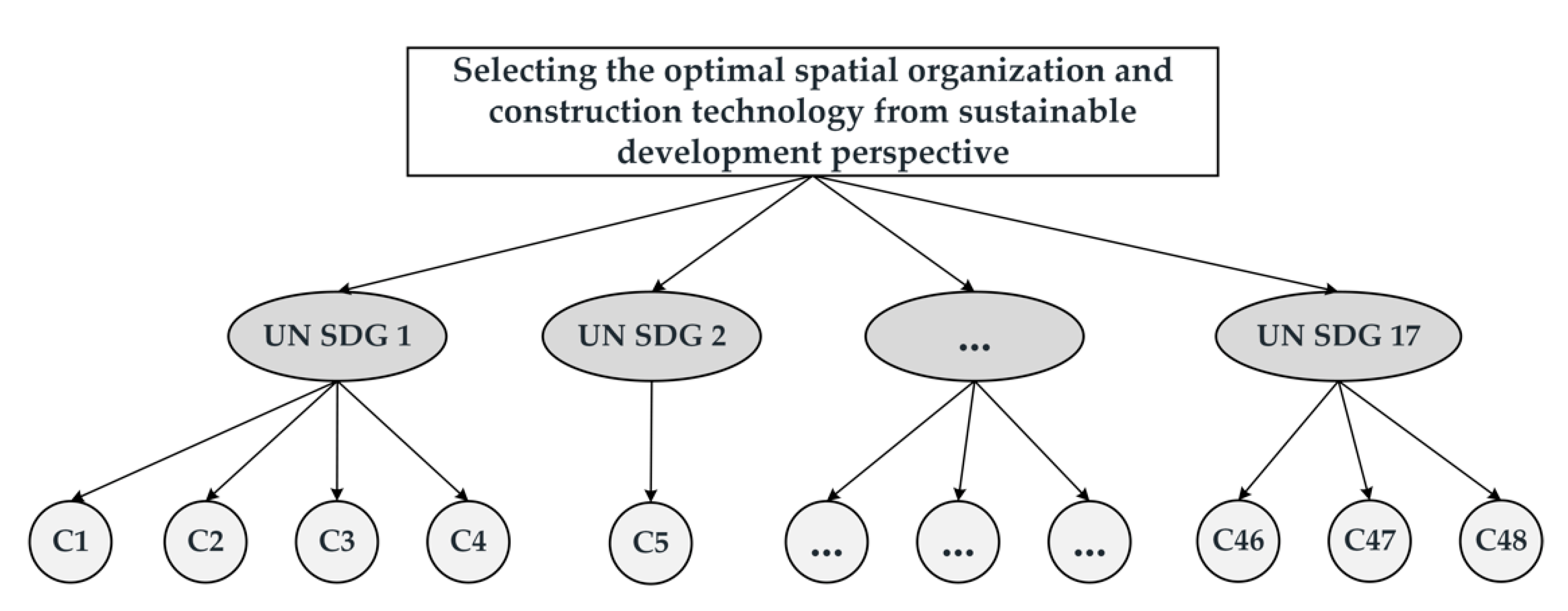
4.1. Sustainability Criteria
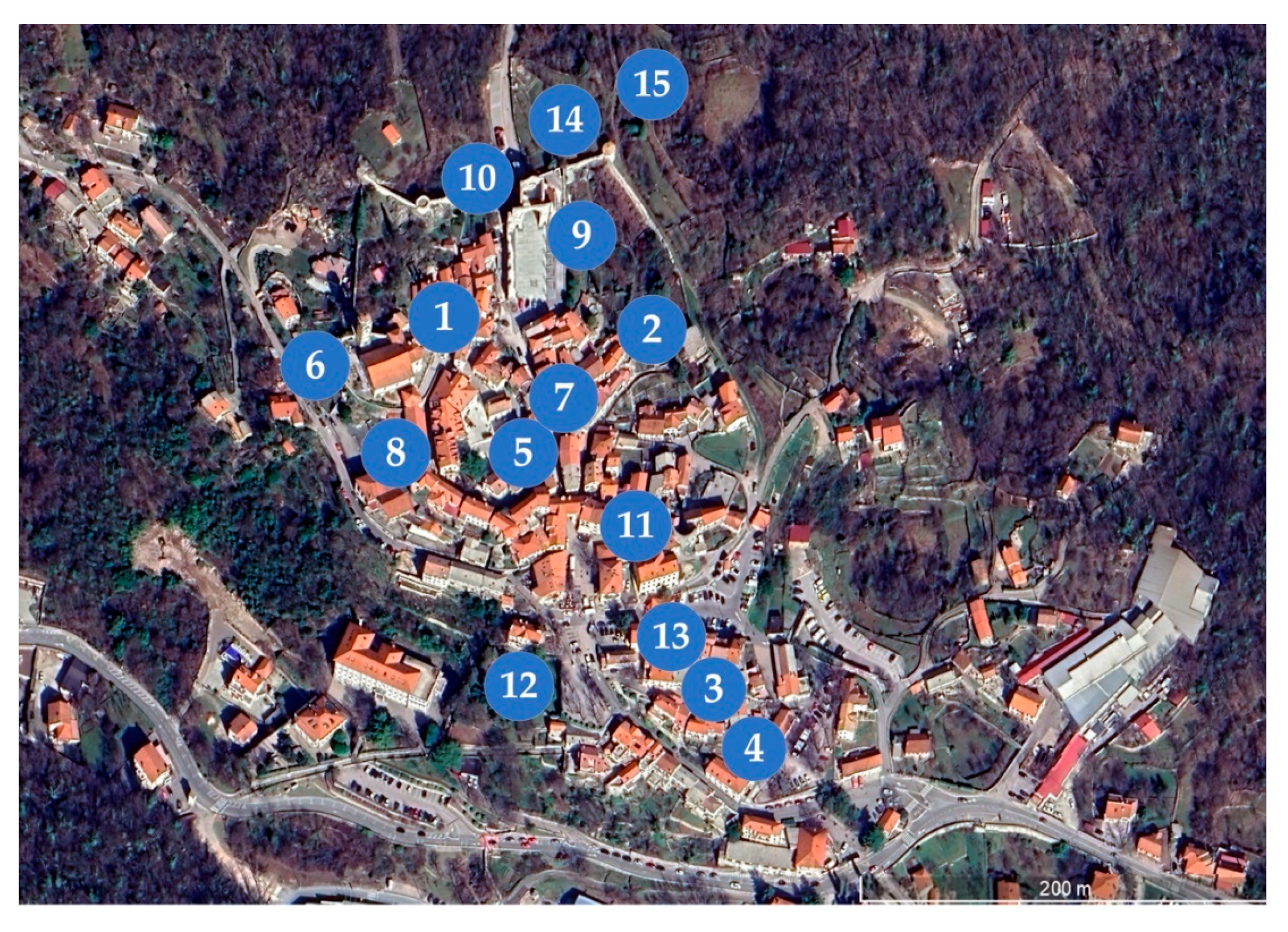
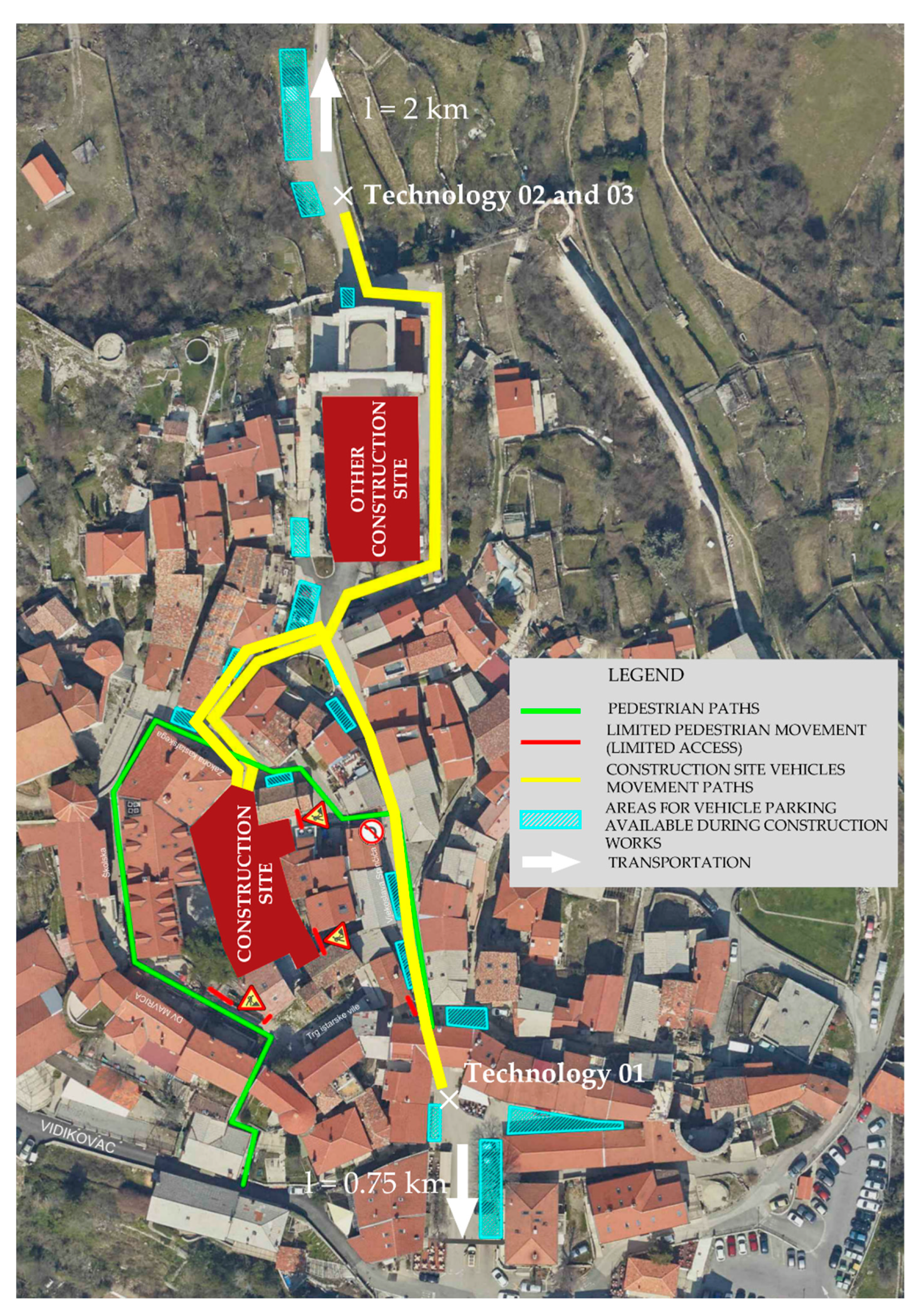
Although the concept of sustainability was first related only to the natural sphere, today it is accepted that there are many aspects to it and it is generally interpreted as being economical, ecological, and social and cultural. When choosing the activities and technologies for intervention in HUL, there are some general aspects to consider related to the spheres of sustainability. Table 2 shows the elaboration of the sustainability spheres criteria.
The UN SDGs are a part of the Resolution Transforming our world: the 2030 Agenda for Sustainable Development, adopted by the General Assembly of the United Nations on 25 September 2015 [3]. There are 17 goals, with each elaborated in several sub-goals. Mostly, they are defined for national and international levels, so their implementation at the local level requires (typically) some elaboration/interpretation to distill the potential meaning or criteria that can be checked on this level. Table 3 shows the analysis of sustainable development criteria based on the analysis of characteristics of Mediterranean settlements (based on data from the literature review).
From the analysis of the elaboration of sustainable development goals—directly from the UN SDGs and by elaborating criteria from characteristics of Mediterranean areas in accordance with SDGs, some criteria turn out to be most important for the choice of spatial organization and construction technology. These 48 criteria are shown in Table 4.

4.2. Kastav

The city of Kastav, in Primorsko-Goranska County, Croatia, is a part of the Adriatic basin, one of six areas of the Mediterranean region, defined by EC Europe 2000+. It was chosen for verification of the evaluation and prioritization model because it presents many characteristics of a “typical” Mediterranean settlement as well as their vulnerabilities: ancient Greek and Mediterranean triple function (sacred, public, and private) [30], typical dense urban structure, elements of small private urban green and other elements (stairs, benches, etc.) occupying “fina”, steep Karstic terrain (typical for South European Mediterranean areas), stratification of cultural and natural elements, presence of water elements (in this case antique cistern), city walls, tall masonry traditional buildings, fragile constructions and infrastructure, touristic presence, scattered newer development in proximity, and others.
Kastav is a small Mediterranean municipality that extends over an area of 11 km2, with 10,265 inhabitants and 3841 households [93]. The first known mention of it was in 1351 [94] (in the major medieval town formation period [95]). The municipality is mostly renowned for its historic heritage, especially its historic urban core, many different smaller rural historic zones, a forest, and also an industrial zone northeast of the historic old center. The area has also population and economic growth and subsequent typical sprawl and scattering development character. The historic center has characteristic city walls, dense urban structure, and hosts a big archeological area of Crekvina.
Kastav borders the City of Rijeka, capital of the county, a portal and ex-industrial city that suffered a deindustrialization process that resulted in the loss of jobs and depopulation, with the sequent transfer of economic activities in its vicinity (such as in the city of Kastav), as was already mentioned as a typical Mediterranean process. On the south and west, it borders the city of Opatija, a major touristic center with more than a century of touristic tradition. In the north, there are important natural and hunting areas, as well as a border with the Republic of Slovenia. Some bigger cities such as Trieste, Ljubljana, and Zagreb, are distant, 50 to 140 km.
Although deindustrialization often had a smaller effect in Mediterranean countries compared to that in Northern European countries, some cities (industrial centers) are the exception. Such is the case of Rijeka, in which the surrounding city of Kastav is located, which has experienced great problems with the loss of industrial jobs and subsequent suburbanization and emigration from the city center towards the peri-urban areas and smaller cities in its vicinity. Similarly, as in examples of some other Mediterranean areas, bigger cities felt more of the effect from the recent crisis, placing smaller cities under strain from uncontrolled development.
The historic center of Kastav (Figure 3) is situated at approximately 330 m above sea level. It has three distinctive zones: southern, traversed by the main road that divides the northern area into two distinctive zones—western and eastern. The main elements of the historic center are shown in Figure 3.
The northwestern zone is located at the highest level and is characterized by the presence of the main square, Lokvina (with antique water cistern), St. Jelena church, dense urban structure with partially amphitheatrical organization [94], terraced terrain, and the presence of a small urban green and larger green area in the northern part of the zone. This zone is considered to be the most ancient. The main square was probably developed on a Karstic geoformation “vrtača” (doline) and is encompassed by the gothic church and structures of the former castle [96]. The northeastern zone is also located on steep terrain and has irregular urban structure but is most recognizable by the important archeological site of Crekvina at the northern entrance to the city (historic center). This zone has also an important presence of green areas. The southern part is characterized by steep terrain and a road that arrives at the city terrace, city loggia, irregular urban texture, and the first square that leads through the southern city entrance—a narrow arched passage, to the northern part of the center. This zone started to develop in the 16th century [94]. It offers exceptional views of the sea and surrounding mountains.
There are important natural areas surrounding the historic center and especially important forest and recreation areas in the north. Heritage is also characterized by natural elements (“vrtače”), terraces, important rock formations, dry stonewalls, and prehistoric archeological sites.
In the proximity of the historic center, there are scattered smaller settlements and also the cemetery, industrial, and commercial zones. Traffic and parking are problematic in the whole historic area but walking and accessibility are also difficult due to the characteristics of the terrain.
The historic center is enclosed by a system of city walls with remains of fortifications (which is among the most important fortification systems in Croatia [96]), which also makes it an example of a fortified city, important as an authentic historic connection [77]. The wall system is characterized today by the stratification of natural elements that, together with built elements, create an important visual and constructive unit, making the intervention of city walls very challenging.
The importance of defense is also visible in its spatial organization (a broken “Y” organization). The urban organization follows a typical medieval urban structure with the main road connecting the two main town entrances [96], but orthogonal roads are somehow less recognizable due to the adaptation to steep terrain. Characteristic features of the historic central area are water cisterns, stone benches along the facades, a system of stairs, “sottoportico”, and steep pedestrian paths. The area of the historic center is 27,000 m2, 46% are built areas, 30% are open public areas, and 24% are gardens and other green areas. The urban structure and its most defining elements seem to have been mostly unchanged at least since 1819 [94] and it is typical of European Mediterranean medieval towns [97]. The area of open public spaces, presence of small urban green, and urban equipment along the facades, are typical of Mediterranean and Adriatic urban structures, such as in [43,65].
The historic center and its surrounding area (with rural, archaeological, and natural heritage) are recognized for protection by the national heritage registry [94,96] and planning documentation [98,99].
The spatial intervention (main spatial elements are shown in Figure 4) considered the renewal of infrastructure and the main Lokvina square situated in the main part of the historic center. The square has the characteristic shape of a lunette defined by rows of buildings (city administration, hotel and restaurant, private residential buildings, and Church of St. Trinity) and a small green area. The buildings and the square have to be functional and accessible all year, and this is one of the important requirements for the choice of the spatial organization of construction works and construction technology. The arrival to the square is very difficult and includes the restricted passage through an arched passage of small dimensions. The terrain is steep and is higher towards the northwest. At the center of the terrain, there was a historical presence of the puddle (hence the name “Lokvina”) that was later, in Ancient Roman times, transformed into a water cistern. This characteristic also posed challenges in terms of the organization and technology of construction works—mainly in terms of the weight and vibrations of construction works.
The proposed SOnCT model was tested in the case study of the Lokvina square reconstruction project. Taking into account all the aforementioned, to do any building interventions on the site one can approach either from the southern side (Figure 3 point 11) or the northern side (Figure 3 point 10). It is not possible to approach from any other way because of the height difference between fortified areas, inside city walls, and surrounding areas. Therefore, it is important to perform investigation activities on-site during the planning phases and create a precise spatial organization and technological plan for the reconstruction (Figure 5) before the start of the construction phase. The reconstruction works on Lokvina square required several different types of construction works, demolition, earthworks, concrete and formwork, and different installations.
As there are only two possible points of entry into the historical center of the city of Kastav (Figure 5, marked with x) the initial plan was to compare four technologies in relation to the defined evaluation criteria that represent the different spatial organization and construction technology based on the UN SDGs. In relation to needed reconstruction works, analyzed technologies differ in the possibilities of only using manpower, using machine power, or using a combination. It is evident that, regardless of the entry location, the biggest difference between technologies is in the work activities related to transport to and from the construction site, namely, the surplus of materials from demolition works, excavated material and embankment material from earthworks, and concrete from concrete and formwork works. Therefore, these materials, i.e., their transport, can be organized in cycles (manpower and/or small vehicles) or continuously (belt conveyors and concrete pumps).
Therefore, the four analyzed spatial organization and construction technologies are set as follows: Technology_01 (south entrance, characterized by a large use of manpower in combination with small machines), Technology_02 (north entrance, characterized by the use of manpower in combination with small machines, belt conveyors, and concrete pumps), Technology_03 (north entrance, characterized by a large use of manpower in combination with small machines), and Technology_04 (south entrance, characterized by the use of manpower in combination with small machines, belt conveyors, and concrete pumps).
The yellow lines in Figure 5 represent transportation paths inside Kastav’s historic center from both entrances. During the preliminary analysis of possible impacts of these technologies, according to Table 3, Technology_04 was dismissed due to the fact that it would occupy almost the whole square in front of the south city entrance that is packed with small business and commercial spaces. Additionally, it was concluded that the technologies from the north entrance seem to be much better, according to the Mediterranean settlement set of characteristics, than from the south, in spite of the fact that transportation to the disposal site is further away and transportation needs to proceed by a narrow macadam road through the forest. As the technologies 01 to 03 are shown in Figure 5, their detailed comparison according to defined criteria is shown in the following section.

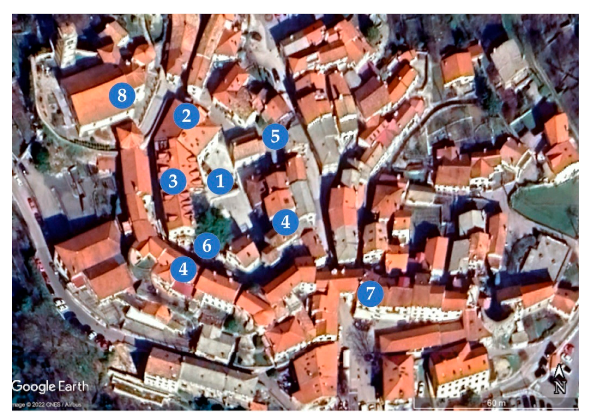
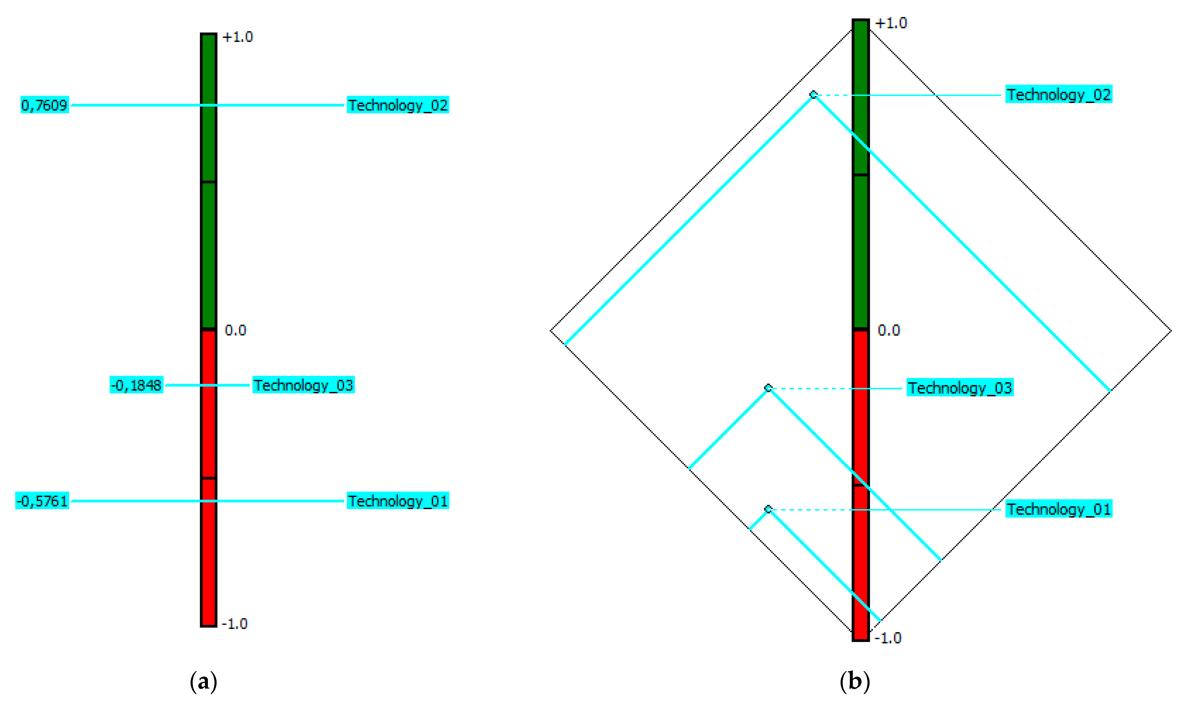
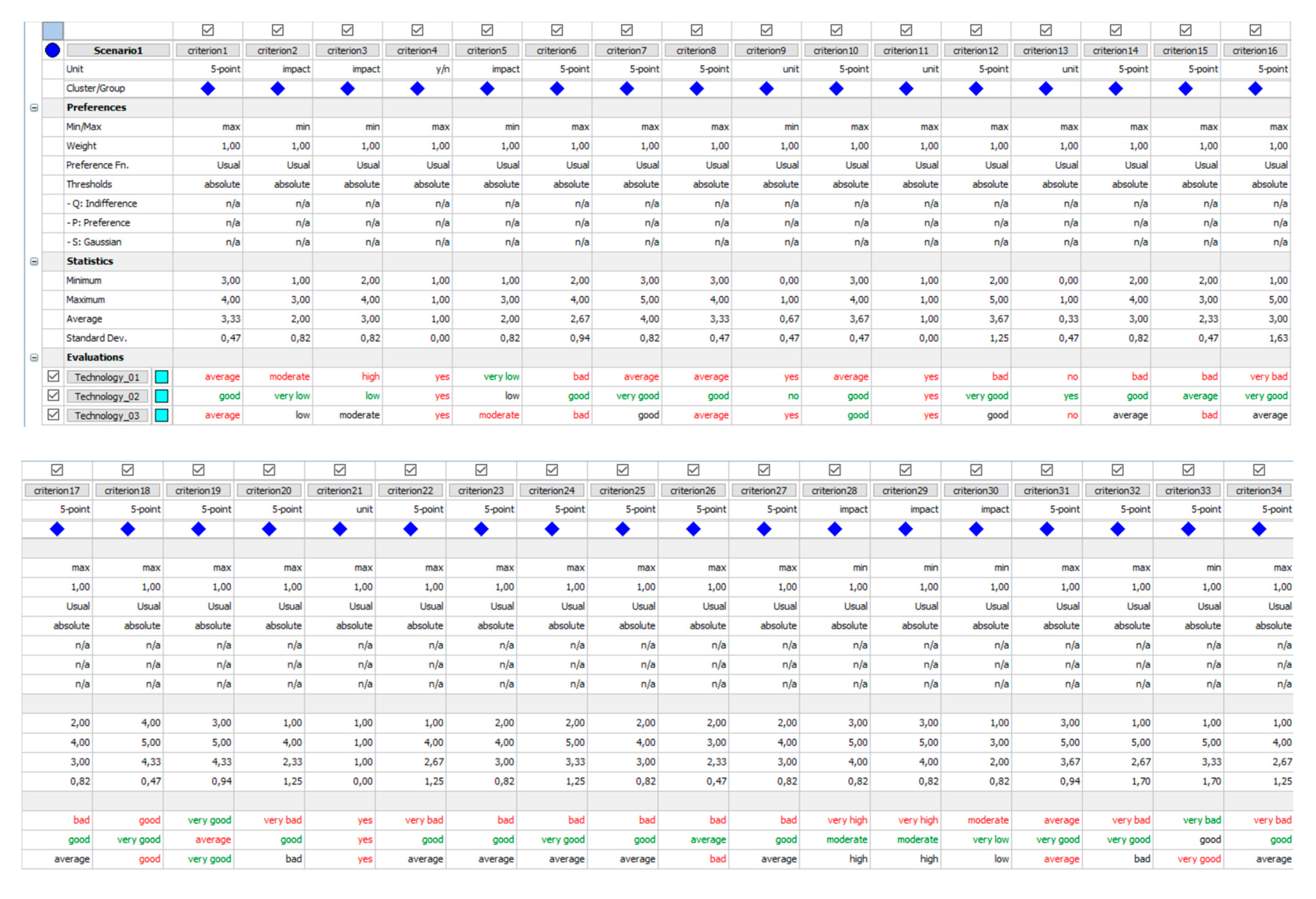
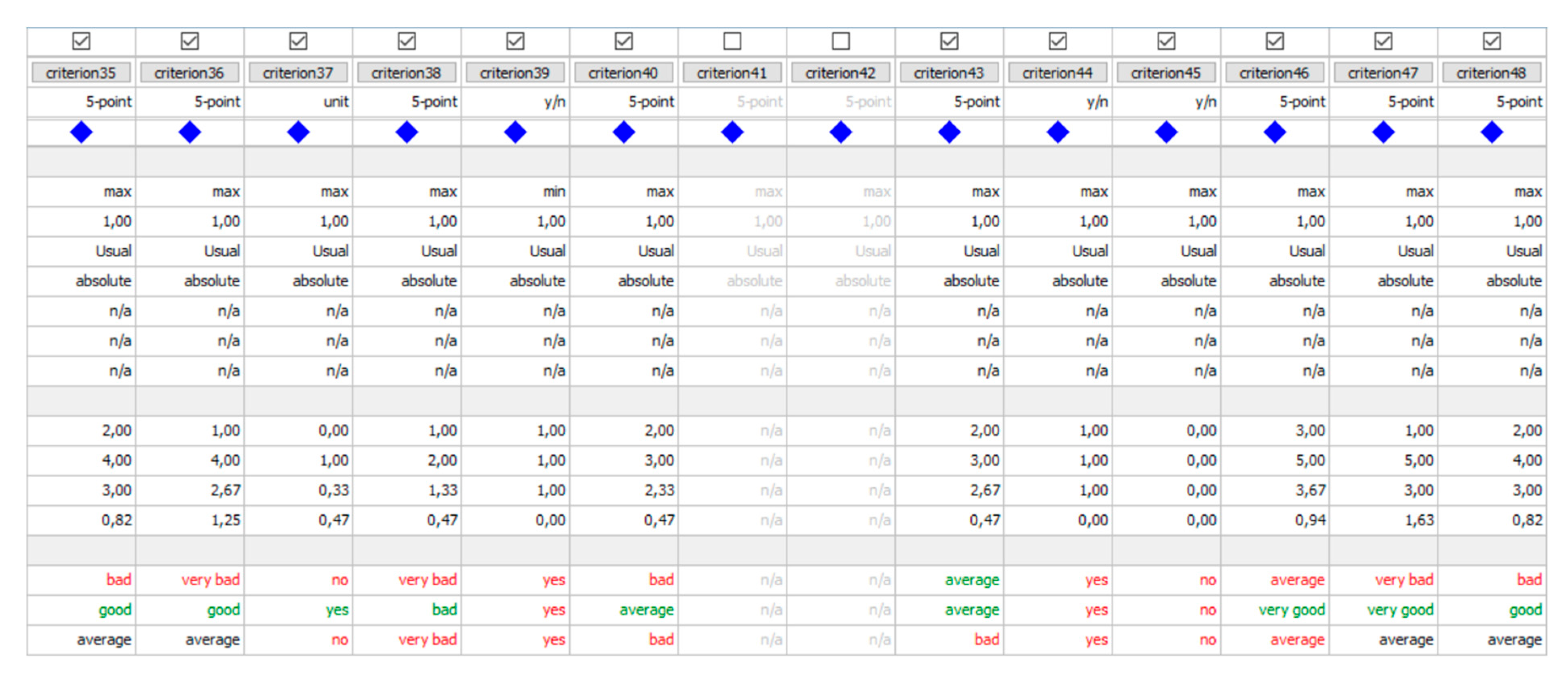
4.3. Results of the SOnCT Model Applied to the City of Kastav

A clear hierarchical goal structure and its weighting give the opportunity to proceed with the SOnCT model in order to evaluate and prioritize given alternatives. In this particular case, the decision-maker has a fixed HGS that gives them open hands in selecting experts that will help them to evaluate alternatives according to those sustainable criteria (Table 4). Of course, in cases of multi-stakeholder involvement, this step can also be based on their compromised point of view.
In the case of selecting the optimal spatial organization and construction technology from a sustainable development perspective on the building intervention in the city of Kastav, the same experts, as previously defined, were used to evaluate four potential alternatives. Their evaluation and preferences are visible in Appendix A (Figure A1) as the whole decision matrix is shown. It is important to highlight that for this HGS, the type of preference function applied to all criteria is the Usual one. This preference function is a very simple and appropriate one for criterion with a few very different evaluations. Such is often the case with qualitative criteria evaluated on a five-level qualitative scale. As criteria for the evaluation and prioritization of different spatial organization and construction technology based on the UN SDGs (Table 4) are defined by an expert as qualitative ones, this is the right preference function to use in the analysis.
Taking all of these into account, PROMETHEE II is used, and results in a complete ranking of all alternatives are presented in Figure 6a. The Phi net flow of each alternative is clearly visible, and it unambiguously shows which alternative is the optimal one. The strengths and weaknesses of each alternative, in relation to all defined criteria, are defined on a +1 (green) to −1 (red) scale. The alternative closest to +1 is perceived as the best one, while the option closest to −1 is perceived as the worst one. Knowing such, it is evident that the alternative “Technology_02” is the best one, i.e., optimal for this particular problem. The large span between the best and the worst alternative (+0.7609 and −0.5761) gives the data analyst insight and confidence that the criteria, in spite of their large number, are solid and correctly defined for this particular decision problem. In addition, the results from Figure 6a indicate that one of the analyzed technologies is a far better choice than the other.
To support such claims, it is also important to test and validate solutions from PROMETHEE II with other tools that VisualPROMETHEE offers. One such tool that can be used for validation is PROMETHEE Diamond and PROMETHEE Network. As each alternative in PROMETHEE Diamond is represented as a point in the Phi plane angled at 45° degrees in relation to the green-red Phi axis, it is evident that the Phi flow values correspond with the ones from PROMETHEE II (see Figure 6a,b). At the same time, the point of each alternative in the Phi plane is presented with Phi+ and Phi−, i.e., the results of the PROMETHEE Network and PROMETHEE I partial ranking. Therefore, the point of each alternative is a coordinate (Phi+, Phi−) that outlines a certain cone. Such is of utmost importance to data analysts and decision-makers as the alternative cones are overlapping or intersecting each other. If one alternative cone overlaps another, it means that the alternative is preferred over the other, while intersecting cones correspond to incomparable alternatives that seek further in detail analysis.
In the example of Figure 6b, it is evident that the cone of alternative “Technology_02” overlaps all the other alternatives and therefore it can be safe to conclude that this alternative is the optimal one.

5. Discussion

The research allows to answer the research questions and discuss the results.
The sustainable development goals for the Mediterranean area can be partially filtered directly from the UN SDGs (for example, those related to water pollution, which can be interpreted as organization or technology pollution water, etc.), but other of the UN SDGs do not allow for such direct translation into criteria. This is so because the UN SDGs are defined mostly regarding national and international policies and tend to lack local aspects and, even more importantly, spatial and technical aspects. Therefore, the UN SDGs had to be elaborated with spatial and technical aspects in mind, considering issues for Mediterranean area settlements. This aspect is an interesting gap in existing theory and practice and shows both the lack of spatial and technical aspects in policies and opens new perspectives for further research.
Although the acknowledgment of the importance of urban structure can be traced at least back to (Sitte [101], The Athens Charter Athens [34], UNESCO Convention [102], and some ICOMOS charters [83]) many sources dealing with the characteristics of Mediterranean urban and landscape environment, it strangely clashes with modern architectural theory [103], and even charters based on it (such as the Venice charter [104]) draw attention towards existing landscape and stratified heritage, a surprisingly contemporary issue.
The spatial characteristics and sustainable development goals of Mediterranean settlements that can impact or be impacted by the choice of intervention technology and spatial organization are different for bigger and smaller Mediterranean cities. Smaller Mediterranean city areas tend to have very different characteristics and models of development from northern cities and are very vulnerable to modification of the urban structure. The research on the Mediterranean spatial characteristics first regarded all Mediterranean areas, while more recently, it was found that South European areas had distinct development patterns due to lower population growth and other characteristics. It is not possible to separate the spatial characteristics of Mediterranean areas from their other characteristics such as economy, way of living, urban and economic dynamics, and so on, but there are still some characteristics that can be highlighted such as:
For historic centers: dense irregular urban structure, high traditional buildings, attention to privacy and views, presence of “fina” (even in areas where it does not have a particular name, such as in northern Adriatic), “sottoportico”, small green areas, stratification of cultural and natural heritage but also immaterial culture, way of living, socialization, urban and social dynamics, local economy, and activities related to tourism. For the rest of the territory, contemporary development is characterized by scattering and sprawl and the high use of natural resources. The development of smaller and bigger towns influences each other, creating pressure on smaller cities and the Mediterranean landscape with their already existing vulnerabilities to all types of spatial interventions, from spatial planning, building, and infrastructure design to construction works.
Therefore, the sustainable development goals for Mediterranean area settlements regard all sustainable development goals that can be directly traced from the UN SDGs without spatial and local components but have to take into consideration all the characteristics regarding local typical local characteristics—preservation of stratified heritage (urban, material, and immaterial) and the diminishing use of resources such as natural and rural terrain (for example because of scattering and sprawl) as well.
The optimal spatial organization and construction technology for needed construction works (based on the given design), can be done by creating and using an evaluation and prioritization model that takes into account the UN SDGs elaborated through sustainable development criteria based both directly on the elaboration of the UN SDGs and elaborating the UN SDGs through main sustainability spheres criteria and spatial and technological characteristics of Mediterranean areas.
The results for the SOnCT model showed that defined criteria in HGS (Figure 2 and Table 4) are correctly defined for a particular decision problem of a building intervention in the historic center of small Mediterranean towns. Such corresponds with prior multi-criteria research into Mediterranean towns, such as [21], but also gives more in detail insight into sustainability, spatial characteristics of Mediterranean towns, and the UN SDGs. The model shows that the best choice of technology is the one that offers not just the sustainable one in the long run [105] but also the sustainable one during the building intervention.
The theoretical part of the paper showed that there is a need to understand that the spatial and technical characteristics of small Mediterranean settlements are those aspects not already defined in the UN SDGs. To define a framework for selecting an optimal spatial organization and construction technology from a sustainable development perspective in this characteristic urban environment (present in a very wide territory), there is a necessity to take into consideration the spatial characteristics of small Mediterranean settlements (for example, dense urban structure, seasonality, social and cultural sustainability, etc.)
The model can be primarily used for small Mediterranean settlements, but also for every other town/or a part of the town, with similar urban characteristics which have to be verified by spatial planning experts. This aspect—a need for expert opinion, might also be considered as a limit of the framework, as well as dependency on the decision-maker to use such a model.
Additionally, the proposed model shows that it is appropriate to use the MCDA approach and adequate methods, especially the logic of the decision support concept, to select the optimal spatial organization and construction technology from a sustainable development perspective: One of the key aspects is a possibility of involving stakeholders into the creation of hierarchical goal study. This particular model gives fixed HGS based on Mediterranean area experts’ points of view that is in relation to other approaches [8,19,20,21,22,23] but fails to include additional experts if needed; this is possible to add as the model is opened. In addition, it is important to note that, due to a large number of criteria, it is not possible to use AHP for alternatives comparison and selecting the optimal solution. Therefore, the PROMETHEE method is a much better method to use as it has no problems with comparing alternatives among a large number of criteria as long as they are hierarchically structured.

6. Conclusions

It is possible to determine how to approach the realization of construction intervention in a small Mediterranean town, based on the UN SDG, using the evaluation and prioritization model for the choice of good (Phase 1) and the best alternative (Phase 2) for the spatial organization and construction technology for a given design.
To do this, it is necessary to implement the spatial aspects characteristic of Mediterranean areas typical of small Mediterranean historic centers and their surrounding areas into the definition of the sustainable development criteria based on the UN SDGs as they do not consider spatial and technical characteristics. This is possible through the analysis of those characteristics, as well as characteristics of the development of those areas, and with consultations with local spatial planning and technology experts.
It is, therefore, possible to create an evaluation and prioritization model that allows for the optimal choice of spatial organization and construction technology in consideration of the goals of sustainable development as well as local spatial characteristics (that include physical configuration, but also built and natural heritage, immaterial heritage, way of living, economic activities, and their temporal fluctuation).
It was also found that even if today there is a growing awareness of the importance of the quality of spatial environment (such as in HUL), the general approach is still impacted by some of the international documents (such as the Venice charter) and modernist approach to cultural heritage that created a gap in our understanding of heritage, making it a distinctly post-modern contemporary topic.
As for the possibility to introduce models as here proposed in procedures of public procurements, it is also necessary to note that some countries introduced Green Public procurement, Public Procurement of Innovative solutions, or Pre-Commercial Procurement according to the EU Commission’s suggestion [106,107], making the similar introduction of the UN SDGs also a potential possibility.

Author Contributions

Conceptualization, I.M. (Ivan Marović), I.M. (Iva Mrak), D.A. and J.K.; methodology, I.M. (Ivan Marović), I.M. (Iva Mrak) and D.A.; software, I.M. (Ivan Marović), I.M. (Iva Mrak) and D.A.; validation, I.M. (Ivan Marović), I.M. (Iva Mrak) and D.A.; formal analysis, I.M. (Ivan Marović), I.M. (Iva Mrak) and D.A.; investigation, I.M. (Ivan Marović), I.M. (Iva Mrak), D.A. and J.K.; resources, I.M. (Ivan Marović), I.M. (Iva Mrak), D.A. and J.K.; data curation, I.M. (Ivan Marović), I.M. (Iva Mrak), D.A. and J.K.; writing—original draft preparation, I.M. (Ivan Marović), I.M. (Iva Mrak) and D.A.; writing—review and editing, I.M. (Ivan Marović), I.M. (Iva Mrak), D.A. and J.K.; visualization, I.M. (Ivan Marović), I.M. (Iva Mrak) and D.A.; supervision, I.M. (Ivan Marović) and I.M. (Iva Mrak); project administration, I.M. (Ivan Marović), I.M. (Iva Mrak) and D.A.; funding acquisition, I.M. (Ivan Marović), I.M. (Iva Mrak) and D.A. All authors have read and agreed to the published version of the manuscript.

Funding

This research received no external funding.

Institutional Review Board Statement

Not applicable.

Informed Consent Statement

Not applicable.

Data Availability Statement

Data are available on request due to restrictions, e.g., privacy or ethics. The data presented in this study are available on request from the corresponding author. The data are not publicly available due to further research being published.

Acknowledgments

This research has been fully supported by the University of Rijeka under the project number uniri-pr-tehnic-19-18 (dsc4sum.gradri.uniri.hr).

Conflicts of Interest

The authors declare no conflict of interest.

Appendix A

Figure A1. Decision matrix from VisualPROMETHEE.
Buildings 12 01233 g0a1aBuildings 12 01233 g0a1b

References

  1. Małczak, L. The Mediterranean in Croatian literature and culture. A view from the outside/Mediteran u hrvatskoj književnosti i kulturi. Pogled izvana. In Peryferie w Chorwackiej Literaturze i Kulturze/Periferno u Hrvatskoj Književnosti i Kulturi; Bagić, K., Levanat-Peričić, M., Małczak, L., Eds.; Wydawnictwo Uniwersytetu Śląskiego: Katowice, Poland, 2021; pp. 167–185. [Google Scholar]
  2. Geić, S.; Geić, J.; Maršić, N. Experience of the Mediterranean and Global Tourist Regions in Sea and Fresh Water Resources Management/Iskustva turističkih regija Mediterana i svijeta u segmentu upravljanja morskim i kopnenim vodenim resursima. Naše More 2011, 58, 148–162. [Google Scholar]
  3. United Nations. Transforming Our World: The 2030 Agenda for Sustainable Development (A/RES/70/1, 25 September 2015); United Nations: New York, NY, USA, 2015; Available online: https://www.un.org/ga/search/view_doc.asp?symbol=A/RES/70/1&Lang=E (accessed on 25 July 2022).
  4. Saaty, T.L. Decision Making for Leaders: The Analytical Hierarchy Process for Decision in a Complex World. The Analytical Hierarchy Process Series; University of Pittsburg: Pittsburg, PA, USA, 2001. [Google Scholar]
  5. Phillips, L.D.; Bana e Costa, C.A. Transparent prioritisation, budgeting and resource allocation with multi-criteria decision analysis and decision conferencing. Ann. Oper. Res. 2007, 154, 51–68. [Google Scholar] [CrossRef]
  6. Ishizaka, A.; Labib, A. Selection of new production facilities with the group analytic hierarchy process ordering method. Expert Syst. Appl. 2011, 38, 7317–7325. [Google Scholar] [CrossRef]
  7. Jajac, N.; Bilić, I.; Mladineo, M. Application of multicriteria methods to planning of investment projects in the field of civil engineering. Croat. Oper. Res. Rev. 2012, 3, 113–124. [Google Scholar]
  8. Macharis, C.; Turcksin, L.; Lebeau, K. Multi actor multi criteria analysis (MAMCA) as a tool to support sustainable decisions: State of use. Decis. Support Syst. 2012, 54, 610–620. [Google Scholar] [CrossRef]
  9. Marović, I.; Završki, I.; Jajac, N. Ranking zones model—A multicriterial approach to the spatial management of urban areas. Croat. Oper. Res. Rev. 2015, 6, 91–103. [Google Scholar] [CrossRef]
  10. Erdogan, S.A.; Šaparauskas, J.; Turskis, Z. A multi-criteria decision-making model to choose the best option for sustainable construction management. Sustainability 2019, 11, 2239. [Google Scholar] [CrossRef]
  11. Saaty, T.L. The Analytic Hierarchy Process; McGraw-Hill International: New York, NY, USA, 1980. [Google Scholar]
  12. Darko, A.; Chan, A.P.C.; Ameyaw, E.E.; Owusu, E.K.; Parn, E.; Edwards, D.J. Review of application of analytic hierarchy process (AHP) in construction. Int. J. Constr. Manag. 2019, 19, 436–452. [Google Scholar] [CrossRef]
  13. Losada Maestre, R.; Sanchez Medero, R.; Berlanga de Jesus, A.; Molina Lopez, J.M. The application of analytic hierarchy process to implement collaborative governance process: The allocation of the urban structural funds in the city of Madrid. J. Multi-Criteria Decis. Anal. 2020, 28, 18–33. [Google Scholar] [CrossRef]
  14. Brans, J.-P.; De Smet, Y. PROMETHEE Methods: Multiple Criteria Decision Analysis; Springer: New York, NY, USA, 2016. [Google Scholar]
  15. Brans, J.P.; Mareschal, B.; Vincke, P.H. PROMETHEE—A New Family of Outranking Methods in Multicriteria Analysis. Operational Research IFORS 84; Brans, J.P., Ed.; North Holland: Amsterdam, The Netherlands, 1984; pp. 477–490. [Google Scholar]
  16. Brans, J.P.; Vincke, P.H. A preference ranking organization method, the PROMETHEE method for MCDM. Manag. Sci. 1985, 31, 647–656. [Google Scholar] [CrossRef]
  17. Behzadian, M.; Kazemzadeh, R.B.; Albadvi, A.; Aghdasi, M. PROMETHEE: A comprehensive literature review on methodologies and applications. Eur. J. Oper. Res. 2010, 200, 198–215. [Google Scholar] [CrossRef]
  18. Macharis, C.; Springael, J.; De Brucker, K.; Verbeke, A. PROMETHEE and AHP: The design of operational synergies in multicriteria analysis. Strengthening PROMETHEE with ideas of AHP. Eur. J. Oper. Res. 2004, 153, 307–317. [Google Scholar] [CrossRef]
  19. Macharis, C.; de Witte, A.; Ampe, J. The multi-actor, multi-criteria analysis methodology (MAMCA) for the evaluation of transport projects: Theory and practice. J. Adv. Transp. 2010, 43, 183–202. [Google Scholar] [CrossRef]
  20. Jajac, N.; Marović, I.; Baučić, M. Decision support concept for managing the maintenance of city parking facilities. Electron. J. Fac. Civ. Eng. Osijek E GfOs 2014, 9, 60–69. [Google Scholar] [CrossRef]
  21. Jajac, N.; Marović, I.; Mladineo, M. Planning support concept to implementation of sustainable parking development projects in ancient Mediterranean cities. Croat. Oper. Res. Rev. 2014, 5, 345–359. [Google Scholar] [CrossRef]
  22. Jajac, N.; Kilić, J.; Rogulj, K. An integral approach to sustainable decision-making within maritime spatial planning—A DSC for the planning of anchorages on the island of Šolta, Croatia. Sustainability 2018, 11, 104. [Google Scholar] [CrossRef]
  23. Marović, I.; Perić, M.; Hanak, T. A multi-criteria decision support concept for selecting optimal contractor. Appl. Sci. 2021, 11, 1660. [Google Scholar] [CrossRef]
  24. Šmit, K.; Mravunac, I. Thematic areas of management plans as indicators of contemporary issues in urban planning Mediterranean cities-Dubrovnik, Venice, Corfu/Tematska područja Planova upravljanja kao indikator suvremenih urbanističkih problema. Mediteranski gradovi-Dubrovnik, Venecija, Krf. Prost. Znan. Časopis Za Arhit. I Urban. 2018, 26, 296–307. [Google Scholar]
  25. Leontidou, L. Alternatives to modernism in (southern) urban theory: Exploring in-between spaces. Int. J. Urban Reg. Res. 1996, 20, 178–195. [Google Scholar] [CrossRef]
  26. Salvati, L. Identity, Change and Sustainability: Towards Post-Mediterranean Cities? Int. J. Humanit. Soc. Sci. 2014, 4, 34–41. [Google Scholar]
  27. Carlucci, M.; Grigoriadis, E.; Rontos, K.; Salvati, L. Revisiting a Hegemonic Concept: Long-term ‘Mediterranean Urbanization’ in Between City Re-polarization and Metropolitan Decline. Appl. Spat. Anal. Policy 2017, 10, 347–362. [Google Scholar] [CrossRef]
  28. Martino, R.; Foglia, L. The city borders: New opportunities for the Mediterranean city. In Less More Architecture Design Landscape. Le vie dei Mercanti X Forum Internazionale di Studi Gambardella; Gambardella, C., Ed.; La Scuola di Pitagora: Naples, Italy, 2012; pp. 1–8. [Google Scholar]
  29. Feleki, E.; Achillas, C.; Vlachokostas, C.; Michailidou, A.V.; Ortega, L.; Moussiopoulos, N. Preservation of the Mediterranean identity: An intra-city analysis towards a macro-regional approach for the characterisation of urban sustainability. Sustainability 2018, 10, 3551. [Google Scholar] [CrossRef]
  30. Capasso, M. Ipotesi di vivibilità e sviluppo di una Medina mediterranea dal cuore antico. In Il Fascino del Centro Antico; Arcidiacono, C., Ed.; Magma Edizioni: Nalpes, Italy, 2004; pp. 125–137. [Google Scholar]
  31. Rodrigo-Comino, J.; Ermini, B. Are cities truly dispersed? A long-term analysis of vertical profile of settlements in Athens’ metropolitan region. Sustainabilty 2021, 13, 3365. [Google Scholar] [CrossRef]
  32. Ciommi, M.; Chelli, F.M.; Carlucci, M.; Salvati, L. Urban growth and demographic dynamics in southern Europe: Toward a new statistical approach to regional science. Sustainability 2018, 10, 2765. [Google Scholar] [CrossRef]
  33. Pace, G. Modi di Pensare e Vedere la Città Mediterranea; Working Paper 2/1998; Irem: Nalpes, Italy; Available online: https://ideas.repec.org/cgi-bin/htsearch?q=Modi+di+pensare+e+vedere+la+città+mediterranea (accessed on 25 July 2022).
  34. ICOMOS. The Athens Charter for the Restoration of Historic Monuments. 1931. Available online: https://www.icomos.org/en/167-the-athens-charter-for-the-restoration-of-historic-monuments (accessed on 25 July 2022).
  35. Corbusier, L. The City of Tomorrow and Its Planning, 8th ed.; Dover Publications: Mineola, NY, USA, 1987. [Google Scholar]
  36. Charter of Athens (1933). IV International Congress for Modern Architecture. The Getty Conservation Institute, Cultural Heritage Policy Documents. Available online: https://www.getty.edu/conservation/about/ (accessed on 25 July 2022).
  37. Hastaoglou-Martinidis, V. Urban aesthetics and national identity: The refashioning of eastern Mediterranean cities between 1900 and 19401. Plan. Perspect. 2011, 26, 153–182. [Google Scholar] [CrossRef]
  38. Krečič, P. Ljubljana—Also Mediterranean city? Plečnik’s Attempt (In Croatian and Slovenian: Ljubljana—I Mediteranski Grad? Plečnikov pokušaj/Ljubljana—Tudi Mediteransko Mesto? Plečnikov Poskus). Vijeće Slovenske Nacionalne Manjine Grada Zagreba/Svet Slovenske Nacionalne Manjšine Mesta Zagreb; Slovenski Dom: Zagreb, Croatia, 2018. [Google Scholar]
  39. Ivanišin, K. Regionalizam ili globalizacija: Budućnost mediteranskog pejzaža. Zarez Dvotjednik Za Kult I Društvena Zbivanja 2002, 78, 32–33. [Google Scholar]
  40. Lopez, L. The urban reality of a Mediterranean city: Bari (Italy). In New Trends in the Renewal of the City; Piñeira Mantiñán, M.J., Moore, N., Eds.; Instituto Universitario de Estudios e Desenvolvemento de Galicia: Santiago de Compostela, Spain, 2011; pp. 87–103. [Google Scholar]
  41. Maricchiolo, L. The modern appropriation of urban space through Mediterranean medinas. In Proceedings of the Regionalism, Nationalism & Modern Architecture Conference Proceedings, Porto, Portugal, 25–27 October 2018; Pimentel, J.C., Trevisan, A., Cardoso, A., Eds.; CEAA: Porto, Portugal, 2018; pp. 221–236. [Google Scholar]
  42. Hakim, B. Generative processes for revitalizing historic towns or heritage districts. Urban Des. Int. 2007, 12, 87–99. [Google Scholar] [CrossRef]
  43. Hakim, B. Mediterranean urban and building codes: Origins, content, impact, and lessons. Urban Des. Int. 2008, 13, 21–40. [Google Scholar] [CrossRef]
  44. Zitti, M.; Ferrara, C.; Perini, L.; Carlucci, M.; Salvati, L. Long-term urban growth and land use efficiency in Southern Europe: Implications for sustainable land management. Sustainability 2015, 7, 3359–3385. [Google Scholar] [CrossRef]
  45. Mrak, I. Evaluation model for cultural heritage in spatial planning. Int. J. Glob. Environ. Issues 2014, 13, 206–234. [Google Scholar] [CrossRef]
  46. Lichfield, N. Economics in Urban Conservation; Cambridge University Press: Cambridge, UK, 1988. [Google Scholar]
  47. Mrak, I. A methodological framework based on the dynamic-evolutionary view of heritage. Sustainability 2013, 5, 3992–4023. [Google Scholar] [CrossRef]
  48. Willems, T.; Gravers, M.; van Krugten, L.T.F.; Tonnaer, L.F.C.M. Methods to assess the cultural significance for preserving historic buildings. In Proceedings of the First International Conference on Living Cities Perspectives, Eindhoven, The Netherlands, 13 January 2015; Roders, A.R., Krishnamurthy, S., Peters van den Heuvel, A., Lammers, D.G.O., Eds.; Technische Universiteit Eindhoven: Eindhoven, The Netherlands, 2015; pp. 1–7. [Google Scholar]
  49. Maroević, I. Into the World with the Cultural Heritage: Museology, Conservation, Architecture/Baštinom u Svijet: Muzeološke Teme, Zaštita Spomenika, Arhitektura; Matica Hrvatska Ogranak Petrinja: Petrinja, Croatia, 2004. [Google Scholar]
  50. Yiota, T. Cultural heritage as a means for local development in Mediterranean historic cities—The need for an urban policy. Heritage 2020, 3, 152–175. [Google Scholar]
  51. Cremaschi, M.; Lieto, L.; Writing Southern theory from the global North. Notes on informality and regulation. Equilibri 2020, 24, 261–280. Available online: https://www.rivisteweb.it (accessed on 25 July 2022).
  52. Mrak, I. Locally based development-tools for identifying opportunities and evaluating port area strategies of Rijeka. Sustainability 2013, 5, 4024–4056. [Google Scholar] [CrossRef]
  53. Venanzoni, G.; Carlucci, M.; Salvati, L. Latent sprawl patterns and the spatial distribution of businesses in a southern European city. Cities 2017, 62, 50–61. [Google Scholar] [CrossRef]
  54. Narodne Novine. Law on Dealing with Illegally Constructed Buildings (In Croatian: Zakon o Postupanju s Nezakonito Izgrađenim Zgradama); Narodne Novine: Zagreb, Croatia, 2019. [Google Scholar]
  55. Zambon, I.; Serra, P.; Sauri, D.; Carlucci, M.; Salvati, L. Beyond the ‘Mediterranean city’: Socioeconomic disparities and urban sprawl in three Southern European cities. Geogr. Ann. Ser. B Hum. Geogr. 2017, 99, 319–337. [Google Scholar] [CrossRef]
  56. Aysegul, K.T. Method for Assessment of the Historical Urban Landscape. Procedia Eng. 2016, 161, 1697–1703. [Google Scholar] [CrossRef]
  57. De Rosa, F.; Di Palma, M. Historic urban landscape approach and port cities regeneration: Naples between identity and outlook. Sustainability 2013, 5, 4268–4287. [Google Scholar] [CrossRef]
  58. Parliamentary Assembly of the Mediterranean. Carta del Mediterraneo; Parliamentary Assembly of the Mediterranean: Principato di Monaco, 2008; pp. 1–15. Available online: https://www.isnitti.edu.it/stdoc/pam_carta.pdf (accessed on 25 July 2022).
  59. Baabou, W.; Grunewald, N.; Ouellet-Plamondon, C.; Gressot, M.; Galli, A. The Ecological Footprint of Mediterranean cities: Awareness creation and policy implications. Environ. Sci. Policy 2017, 69, 94–104. [Google Scholar] [CrossRef]
  60. United Nations Environment Programme. UN Mediterranean Action Plan/Convention on the Protection of the Mediterranean Sea Against Pollution (Barcelona Convention). Available online: https://eur-lex.europa.eu/legal-content/EN/TXT/PDF/?uri=CELEX:21976A0216(01)&from=EN (accessed on 25 July 2022).
  61. Mrak, I. Cultural goods as bearers of cultural and economic values. Vjesn. Državnog Arh. U Rijeci 2013, 53, 139–164. [Google Scholar]
  62. Mossetto, G.; Vecco, M. L‘economia e la gestione del patrimonio edificato. In Economics of Monumental Heritage (In Italian: Economia del Patrimonio Monumentale); Mossetto, G., Vecco, M., Eds.; FrancoAngeli: Milano, Italy, 2001; pp. 21–35. [Google Scholar]
  63. Aragona, S. Gentrification and UN 2020–2030 agenda. Arch Extra. 2019, 12, 340–351. [Google Scholar]
  64. Škrbić Alempijević, N. Why do we need the Mediterranean? Defining the Mediterranean imaginary in contemporary Croatia (In Croatian: Zašto trebamo Mediteran? Pozivanje na sredozemni imaginarij u suvremenoj Hrvatskoj). In Redrawing Borders: Transformations of Identity and Redefinition of Cultural Regions in New Political Circumstances (In Croatian and in Slovenian: Ponovno Iscrtavanje Granica: Transformacije Identiteta i Redefiniranje Kulturnih Regija u Novim Političkim Okolnostima/Ponovno Izrisovanje Meja: Transformacije Identitet in Redefiniranje Kulturnih Regij v Novih Političnih Okoliščinah); Belaj, M., Čiča, Z., Matkovič, A., Porenta, T., Škrbić Alempijević, N., Eds.; Hrvatsko Etnološko Društvo: Zagreb, Croatia; Slovensko Etnološko Društvo: Ljubljana, Slovenia, 2014; pp. 27–47. [Google Scholar]
  65. Prelog, M. Works. Volume I: Space Time (In Croatian: Djela. Svezak I: Prostor Vrijeme); Grafički Zavod Hrvatske: Zagreb, Croatia, 1991. [Google Scholar]
  66. Mrak, I. Metode procjene u funkciji očuvanja graditeljske baštine. Gradjevinar 2014, 66, 127–138. [Google Scholar]
  67. Ashworth, G.J.; Howard, P. European Heritage Planning and Management; Intellect: Exeter, UK, 1999. [Google Scholar]
  68. Fusco Girard, L.; Nijkamp, P. The evaluation in the tactical and implementation / management level of sustainable development (In Italian: La valutazione nel livello tattico ed attuativo/gestionale dello sviluppo sostenibile). In Assessments for the Sustainable Development of the City and the Territory (In Italian: Le Valutazioni per lo Sviluppo Sostenibile Della Città e del Territorio); Fusco Girard, L., Nijkamp, P., Eds.; FrancoAngeli: Milano, Italy, 1997; pp. 98–122. [Google Scholar]
  69. UNESCO. Recommendation on the Historic Urban Landscape; UNESCO: Paris, France, 2011; pp. 1–64. [Google Scholar]
  70. Carrà, N.; Pultrone, G. Cultural heritage for the construction of social capital in the agenda 2030 territorialization process. ArcHistoR 2019, 12, 330–339. [Google Scholar]
  71. Mela, A.; Belloni, M.C.; Davico, L. Sociology and Territorial Planning (In Italian: Sociologia e Progettazione del Territorio); Carocci: Rome, Italy, 2000. [Google Scholar]
  72. Marasović, T. Active Approach to Built Heritage (In Croatian: Aktivni Pristup Graditeljskom Nasljeđu); Sveučilište u Splitu—Filozofski fakultet u Zadru, Društvo konzervatora Hrvatske Zagreb; Arhitektonski Fakultet Sveučilišta Zagreb: Zagreb, Croatia, 1984. [Google Scholar]
  73. Amico, A.D.; Currà, E. The Role of Urban Built Heritage in Qualify and Quantify Resilience. Specific Issues in Mediterranean City. Procedia Econ. Financ. 2014, 18, 181–189. [Google Scholar] [CrossRef]
  74. Carta, M. The Cultural Armour of the Territory. Cultural Heritage as an Identity Matrix and Development Tool (In Italian: L’armatura Culturale del Territorio. Il Patrimonio Culturale Come Matrice di Identità e Strumento di Sviluppo); FrancoAngeli: Milano, Italy, 2002. [Google Scholar]
  75. Giucastro, F.G.S.; Giordano, D. Et(h)nic Architecture in Mediterranean Area. Energy Procedia 2016, 96, 868–880. [Google Scholar] [CrossRef]
  76. UNESCO World Heritage Centre. The UNESCO Recommendation on the Historic Urban Landscape, Report of the Second Consultation on its Implementation by Member States, 2019; UNESCO World Heritage Centre: Paris, France, 2019. [Google Scholar]
  77. Maroević, I. The present of heritage (In Croatian: Sadašnjost baštine). In Društvo Povjesničara Umjetnosti SR Hrvatske Knjiga XXXVI; Društvo Konzervatora Hrvatske Sveučilište u Zagrebu: Zagreb, Croatia, 1986. [Google Scholar]
  78. Mariano, C.; Marino, M. Public space and climate change. Innovative planning approaches for the urban regeneration of coastal cities. In Proceedings of the International Conference on Changing Cities IV, Spatial, Design, Landscape & Socioeconomics Dimensions, Chania, Greece, 24–29 June 2019; Gospodini, A., Ed.; University of Thessaly, Department of Planning and Regional Development, Laboratory of Urban Morphology & Design: Volos, Greece, 2019; pp. 1772–1783. [Google Scholar]
  79. Nocca, F. The role of cultural heritage in sustainable development: Multidimensional indicators as decision-making tool. Sustainability 2017, 9, 1882. [Google Scholar] [CrossRef]
  80. Campisi, T.; Mrak, I.; Errigo, M.F.; Tesoriere, G. Participatory planning for better inclusive urbanism: Some consideration about infrastructural obstacles for people with different motor abilities. In AIP Conference Proceedings; AIP Publishing LLC: Melville, NY, USA, 2021. [Google Scholar]
  81. Mrak, I. The walkability of city with difficult terrain—Evaluation of barriers to use of spatial qualities for users and main guidelines for improvement. In Pedestrians, Urban Spaces and Health, Proceedings of the XXIV International Conference on Living and Walking in Cities LWC, Brescia, Italy, 12–13 September 2019; Tira, M., Pezzagno, M., Richiedei, A., Eds.; Tira, M., Pezzagno, M., Richiedei, A., Eds.; CRC Press: London, UK, 2020. [Google Scholar]
  82. Rey-Pérez, J.; Pereira Roders, A. Historic urban landscape: A systematic review, eight years after the adoption of the HUL approach. J. Cult. Herit. Manag. Sustain. Dev. 2020, 10, 233–258. [Google Scholar] [CrossRef]
  83. The Australia ICOMOS. Burra Charter: The Australia ICOMOS Charter for Places of Cultural Significance; The Australia ICOMOS: Burwood, Austrailia, 2013. [Google Scholar]
  84. Salvati, A.; Coch, H.; Morganti, M. Effects of urban compactness on the building energy performance in Mediterranean climate. Energy Procedia 2017, 122, 499–504. [Google Scholar] [CrossRef]
  85. Fernandes, J.; Dabaieh, M.; Mateus, R.; Bragança, L. The influence of the Mediterranean climate on vernacular architecture: A comparative analysis between the vernacular responsive architecture of southern Portugal and north of Egypt. In Proceedings of the World Sustainable Buildings 2014 Barcelona Conference, Madrid, Spain, 28–30 October 2014; Green Building Council Espana: Madrid, Spain, 2014; pp. 264–270. [Google Scholar]
  86. VisualPROMETHEE. Available online: http://www.promethee-gaia.net/software.html (accessed on 15 July 2022).
  87. Marović, I.; Car-Pušić, D.; Hrvatin, Z. Establishing a model to evaluate public administration projects. Electron. J. Fac. Civ. Eng. Osijek E GfOs 2014, 5, 56–66. [Google Scholar] [CrossRef]
  88. Jajac, N.; Bilić, I.; Ajduk, A. Decision Support Concept to Management of Construction Projects—Problem of Construction Site Selection. Croat. Oper. Res. Rev. 2013, 4, 235–247. [Google Scholar]
  89. Rogulj, K.; Jajac, N.; Simic, F. Decision support concept for construction design project—Selecting the type of glass facade. Croat. Oper. Res. Rev. 2017, 8, 333–350. [Google Scholar] [CrossRef]
  90. Kilić Pamuković, J.; Rogulj, K.; Dumanić, D.; Jajac, N. A sustainable approach for the maintenance of asphalt pavement construction. Sustainability 2021, 13, 109. [Google Scholar] [CrossRef]
  91. Hazir, O.A. A review of analytical models, approaches and decision support tools in project monitoring and control. Int. J. Proj. Manag. 2015, 33, 808–815. [Google Scholar] [CrossRef]
  92. Kim, J.I.; Kim, J.; Fischer, M.; Orr, R. BIM-based decision-support method for master planning of sustainable large-scale developments. Autom. Constr. 2015, 58, 95–108. [Google Scholar] [CrossRef]
  93. Croatian Bureau of Statistics. Census of Population, Households and Dwellings 2021 First Results by Settlements/Popis Stanovništva, Kućanstava i Stanova 2021. Prvi rezultati po naseljima; Republic of Croatia, Croatian Bureau of Statistics: Zagreb, Croatia, 2022; Available online: https://podaci.dzs.hr/media/ixpn5qzo/si-1711-popis-stanovnistva-kucanstava-i-stanova-2021-prvi-rezultati-po-naseljima.pdf (accessed on 25 July 2022).
  94. Vučetić, R.; Haničar Buljan, I. Kastav—Urban-Conservation Study of the Historical Core of the City of Kastav Public Spaces Ground Floor with a Proposal for Renewal and Protection (In Croatian: Kastav—Urbanističko—Konzervatorska Studija Partera Javnih Prostora Povijesne Jezgre Grada Kastva s Prijedlogom za Obnovu i Zaštitu); Institut za Povijest Umjetnosti: Zagreb, Croatia, 2016. [Google Scholar]
  95. Košir, F. The Idea of the City (In Slovenian: Zamisel Mesta); Slovenska matica v Ljubljani: Ljubljana, Slovenia, 1993. [Google Scholar]
  96. Vučetić, R.; Haničar Buljan, I. Kastav City Walls—Urban-Conservation Study of the Kastav City Walls with a Presentation Concept (In Croatian: Kastav Gradske Zidine—Urbanističko-Konzervatorska Studija Gradskih Zidina Kastva s Konceptom Prezentacije); Institut Za Povijest Umjetnosti: Zagreb, Croatia, 2016. [Google Scholar]
  97. Marinović-Uzelac, A. Settlements, Cities, Spaces (In Croatian: Naselja, Gradovi, Prostori); Izdavačka Radna Organizacija—Tehnička knjiga: Zagreb, Croatia, 1986. [Google Scholar]
  98. Registar Prostornih Planova. City of Kastav Spatial Regulation Plan (In Croatian: Prostorni Plan Uređenja Grada Kastva). SN 2021-09. Available online: https://zavod.pgz.hr/planovi_i_izvjesca/registar-prostornih-planova.ml (accessed on 25 July 2022).
  99. Urban Regulation Plan 1 of a Part of Kastav Settlement Building Area, Labelled N1-a (URP1) (In Croatian: Urbanistički Plan Uređenja 1 Dijela Građevinskog Područja Naselja Kastav, Oznake N1-a (UPU 1)). SN 2022-08. Available online: https://zavod.pgz.hr/planovi_i_izvjesca/registar-prostornih-planova.ml (accessed on 25 July 2022).
  100. Krstičević, J. Challenges of Construction Works in Historic Centers (In Croatian: Problematika Izvođenja Građevinskih Radova u Starogradskim Jezgrama). Bachelor’s Thesis, Faculty of Civil Engineering, University of Rijeka, Rijeka, Croatia, 2021. [Google Scholar]
  101. Camillo, S. The Art of Building Cities: City Building According to Its Artistic Fundamentals (In Italian: L’arte di Costruire le Città. L’Urbanistica Secondo i suoi Fondamenti Artistici), 1st ed.; Jaca Book: Milano, Italy, 2007. [Google Scholar]
  102. UNESCO. Convention Concerning the Protection of the World Cultural and Natural Heritage; UNESCO: Paris, France, 1972; Available online: https://whc.unesco.org/archive/convention-en.pdf (accessed on 25 July 2022).
  103. Ambruš, D.; Dusparić, V. Architectural form as a construction (2014) (In Croatian: Arhitektonska forma kao struktura (2014)). In Returning the City (In Croatian: Vraćanje Grada); Strand—Asocijacija za Razvoj Održive Urbane Zajednice: Belgrad, Serbia, 2019. [Google Scholar]
  104. ICOMOS. International Charter for the Conservation and Restoration of Monuments and Sites (The Venice Charter 1964); ICOMOS: Paris, France, 1965; Available online: https://www.icomos.org/charters/venice_e.pdf (accessed on 25 July 2022).
  105. Hanak, T.; Marović, I.; Pavlović, S. Preliminary identification of residential environment assessment indicators for sustainable modelling of urban areas. Int. J. Eng. Model. 2014, 27, 61–68. [Google Scholar]
  106. ASviS. Urban Agenda for Sustainable Development. Goals and Proposals (In Italian: Agenda Urbana per lo Sviluppo Sostenibile. Obiettivi e Proposte); Vitali, W., Fini, G., Bovini, G., Eds.; L’Alleanza Italiana per lo Sviluppo Sostenibile (ASviS): Rome, Italy; Urban@it—Centro Nazionale di Studi per le Poliche Urbane: Rome, Italy, 2018; Available online: https://asvis.it/public/asvis/files/AgendaUrbana.pdf (accessed on 25 July 2022).
  107. European Commission. Innovative and Responsible Public Procurement in Cities. Available online: https://ec.europa.eu/info/eu-regional-and-urban-development/topics/cities-and-urban-development/priority-themes-eu-cities/innovative-and-responsible-public-procurement-cities_en (accessed on 25 July 2022).
Figure 1. Research phases diagram.
Buildings 12 01233 g001
Figure 2. Hierarchical goal structure for the SOnCT model.
Buildings 12 01233 g002
Figure 3. Kastav historic center: 1—Historic center northwestern zone, 2—Historic center northeastern zone, 3—Historic center southern zone, 4—main road, 5—Lokvina square with ancient water cistern, 6—St. Jelena Church, 7—St. Trinity Church, 8—Hotel, ex-castle, 9—archaeological site Crekvina, 10—Northern City entrance, 11—Southern City entrance with the arched passage, 12—City terrace, 13—City loggia, 14—City walls, and 15—a forest with recreational area and rural area (on Google Earth image).
Buildings 12 01233 g003
Figure 4. The central part of the intervention area: 1—Lokvina square with ancient water cistern, 2—City administration, 3—Hotel and restaurant, ex-castle, 4—private residential buildings, 5—St. Trinity Church, 6—green area, 7—Southern City entrance with the arched passage, and 8—St. Jelena church (on Google Earth image).
Buildings 12 01233 g004
Figure 5. Organization scheme for building intervention in the historic center of the city of Kastav—topographic view of analyzed alternatives (modifications made based on [100]).
Buildings 12 01233 g005
Figure 6. Results of multicriteria analysis from the SOnCT model by means of the VisualPROMETHEE software: (a) PROMETHEE II; (b) PROMETHEE Diamond.
Buildings 12 01233 g006
Table 1. Characteristics of urban structure in a Mediterranean area.
Spatial-Technical AspectCharacteristicAuthors
Urban formCompact
Narrow streets
Galleries
[85]
Urban structure
Surrounding landscape
Public open spaces
Complexity due to stratification and adaptation to land
Adaptation to climate
Passages
Lights and shadows
Dilatations and contractions
[41]
Urban rhythms
Forms of representation
Stratification
Movement
[40]
Minimum damage
Spaces of transition between private and public
[43]
Building formPatio
Less surface
Screens
Vegetation
Grids
Small openings
Evaporative cooling
Water elements
Light color
[85]
Architecture[29]
Visuals[43]
IntangibleEconomic activities
Food
Events
Behavior
Informality
Communities
Sensuous geography
[40]
Table 2. Main categories of impacts related to spheres of sustainability.
Sphere of SustainabilityNo.Spatial-Technological CriteriaRelated SDGFunction Direction
Ecological1Technology that pollutes soil, water, and air (as gasses and articles or ionic and non-ionic radiation)2, 3, 6, 11, 14MIN
2Allows for recycling and purification6, 11, 12MAX
3Organization and technology that require additional spaces in natural areas (for example outside of built areas)11, 12, 15MIN
4Use of sustainable energy7, 11MAX
Economic5Problems with optimization of resource use7, 11, 12, 14, 17MIN
6Price/efficiency and efficacy8, 11, 17MAX
7Education during use1, 4, 7MAX
8Need for new infrastructure (such as roads and other infrastructure)11, 15MIN
Social9Activities and technologies that produce noise3, 11MIN
10Activities and technologies that disturb social space3, 11MIN
11Activities that disturb the communication of the local community3, 11MIN
12Interruption of the continuation of everyday life and social activities3, 11MIN
13Interruption of the continuation of economic activities3, 8, 10, 11, 13MIN
Cultural14Activities and technologies that impact material cultural heritage11MIN
15Activities and technologies that impact immaterial cultural heritage11MIN
Compiled by planning experts (based on four spheres of sustainable development) and used for the 1st phase of the evaluation and prioritization model.
Table 3. Analysis of possible impacts on the spatial organization and construction technology related to the characteristics of small Mediterranean towns.
Mediterranean Settlement Set of CharacteristicsSpatial-Technological CriteriaRelated SDG
Urban structure—narrow, chaoticPossibility of use of small irregular streets and other public spaces, especially without stopping regular physical communication11
Activities that fit the best into a local seasonal pattern11
Activities that do not impact the height of ground floor passages or impact them minimally (with verification for safety)3, 11
Concentrated dense structureTraffic organization that allows covering all needs and safety2, 9, 11
Traffic organization that does not require additional areas outside built areas2, 9, 11
Activities that do not produce further peri-urbanization and scattering of urban areas 11, 15
Activities that do not impact the existing material presence11
Functional mixActivities that do not disturb different functions—communication, pauses, discussion, access, and infrastructure function (water, sewage, other infrastructure), especially private3, 6, 11
Small green areasActivities that allow the maintenance and use of existing green3, 11, 16
Relationship with seaActivities that allow uninterrupted activities at the seaside and sea
Activities without pollution
1, 9, 11, 14
1, 9, 11, 14
Traditional buildingsActivities that do not produce vibrations11
Activities that do not produce noise11
Activities that do not produce an impact on the construction of existing buildings11
Activities that do not produce dust and pollution11
Activities that do not impact characteristics of historic construction—small loadbearing capacity, vibration sensitivity, humidity 9, 11
TourismAllow for the continuation of activities1, 11
ClimateActivities and technologies that do not cause higher temperatures and glow11, 13
Activities and technologies that do not cause stronger wind or that mitigate wind11, 13
Activities that mitigate climate, especially in traditional ways11, 13
Table 4. Criteria for the evaluation and prioritization of different spatial organization and construction technology based on the UN SDGs and elaboration based on expert input.
SDGPotential CriteriaFunction Direction
Goal 1. End poverty in all its forms everywhereC1—Choice of organization and technology that guarantees access to basic servicesMAX
C2—Organization/technology oriented to diminish the risk to persons, unities, health, heritage, socioeconomic assets, and ecosystemsMAX
C3—Organization/technology takes measures that prevent and reduce hazard exposure and vulnerability to disaster, increasing preparedness for response and recoveryMAX
C4—Opening of new jobs/labor intensityMAX
Goal 2. End hunger, achieve food security and improved nutrition, and promote sustainable agricultureC5—Interventions/technologies that do not impact agricultural areasMAX
Goal 3. Ensure healthy lives and promote well-being for all at all agesC6—Technologies and organizations that do not create the risk of injury and death for persons working and/or passing nearbyMAX
C7—Traffic organization that allows covering all needs and safetyMAX
C8—Technologies that do not pollute the air (as gasses and articles or ionic and non-ionic radiation), water, or soil, or that improve their qualityMAX
C9—Technologies that produce dustMIN
Goal 4. Ensure inclusive and equitable quality education and promote lifelong learning opportunities for allC10—Opportunity for education and training using contemporary equipment, as well as historic construction and environmental protection-oriented techniques MAX
C11—Collaboration with educational institutions and specialized institutions with the goal of learning new skillsMAX
Goal 5. Achieve gender equality and empower all women and girls C12—Use of technologies that allow for equal work for everyoneMAX
Goal 6. Ensure availability and sustainable management of water and sanitation for allC13—Technologies that purify and recycle waterMAX
Goal 7. Ensure access to affordable, reliable, sustainable, and modern energy for allC14—Use of energy-efficient technologies and organizationMAX
C15—Technologies based on contemporary and advanced sustainable resources of energyMAX
Goal 8. Promote sustained, inclusive, and sustainable economic growth, full and productive employment, and decent work for allC16—Innovative technologies that achieve higher productivityMAX
C17—Technologies that increase the quality of jobsMAX
C18—Technologies that increase work safetyMAX
C19—Technologies that are accessible to micro, small, and medium enterprisesMAX
Goal 9. Build resilient infrastructure, promote inclusive and sustainable industrialization, and foster innovationC20—Technologies and materials with low CO2 emission per unit of value addedMAX
C21—Technologies that result from domestic technology development, research, and innovation in developing countriesMAX
Goal 10. Reduce inequality within and among countries
Goal 11. Make cities and human settlements inclusive, safe, resilient, and sustainableC22—Organization and technologies that do not negatively impact transportation and accessibility (especially for vulnerable groups)MAX
C23—Implementation of procedures for inclusive and sustainable urbanizationMAX
C24—Technologies that allow sustainable waste managementMAX
C25—Technologies and organizations that do not negatively impact cultural and natural heritageMAX
Activities and technologies without impact on material cultural heritageC26—Possibility of use of small irregular streets and other public spaces, especially without stopping regular physical communication and use of infrastructureMAX
C27—Activities that allow the maintenance and use of existing green spacesMAX
C28—Activities that produce vibrationsMIN
C29—Activities that produce noiseMIN
C30—Activities that produce an impact on the construction of existing buildingsMIN
C31—Activities that do not impact the existing material presenceMAX
C32—Activities that mitigate climate, especially in traditional waysMAX
C33—Activities that produce further peri-urbanization and scattering of urban areasMIN
Activities and technologies without an impact on immaterial cultural heritageC34—Activities that do not disturb social space and communication for the local community, allowing for the continuation of everyday life and social activitiesMAX
C35—Activities that fit the best into a local seasonal patternMAX
Goal 12. Ensure sustainable consumption and production patternsC36—Technologies that use resources sustainably, especially energy and materialsMAX
C37—Technologies that produce the least waste, allow the recycling and reuse of materials or energyMAX
C38—Public procurement that promotes sustainable development as a goalMAX
C39—Organization and technologies that require additional areas outside built areas
Goal 13. Take urgent action to combat climate change and its impactsC40—Technologies that diminish or mitigate climate change effects (temperature, glow, rain, wind, etc.)MAX
Goal 14. Conserve and sustainably use the oceans, seas, and marine resources for sustainable developmentC41—Technologies that reduce marine pollution
C42—Activities that allow uninterrupted activities at the seaside and at seaMAX
Goal 15. Protect, restore, and promote the sustainable use of terrestrial ecosystems, sustainably manage forests, combat desertification, and halt and reverse land degradation, halting biodiversity lossC43—Technologies that do not cause desertification, halt and reverse land degradation and halt biodiversity lossMAX
Goal 16. Promote peaceful and inclusive societies for sustainable development, provide access to justice for all, and build effective, accountable, and inclusive institutions at all levelsC44—Transparent public procurement methods in all phases—before, during, and after construction worksMAX
C45—Opportunity for public participation in the choice of technologyMAX
Goal 17. Strengthen the means of implementation and revitalize the Global Partnership for Sustainable Development C46—Multi-stakeholder organization with knowledge and skills exchange, especially towards developing and developed countriesMAX
C47—Price/efficiency and efficacyMAX
C48—Multi-partner organization from various sectors (private enterprises, education, etc.)MAX
Publisher’s Note: MDPI stays neutral with regard to jurisdictional claims in published maps and institutional affiliations.

