Article

Understanding Ganghwa Dondae Forts as a Vernacular Model of Construction and Reuse

Department of Heritage Conservation and Restoration, Korea National University of Cultural Heritage, Buyeo 33115, Korea
*
Author to whom correspondence should be addressed.
Buildings 2022, 12(5), 568; https://doi.org/10.3390/buildings12050568
Submission received: 14 March 2022 / Revised: 12 April 2022 / Accepted: 18 April 2022 / Published: 28 April 2022
(This article belongs to the Special Issue Research on Vernacular Architecture)

Abstract

:
The Dondae forts of Ganghwa Island in the late Joseon dynasty are significant as a maritime defense heritage. Thus far, research on Dondae has focused on historical sources. This study concentrates on essential interpretation to comprehend the vernacular architectural characteristics of the forts as a fixed facility. Confirming the purpose of the construction provides a deeper understanding of the appearance of the late Joseon dynasty beyond the current modified Ganghwa Dondae. This study utilizes standard models of fort architecture established during King Sukjong’s regime and confirms the unique value of military forts, which evolved through a myriad of political changes. Furthermore, this study addresses the sustainable conservation of fort architecture through the continual reuse of the yeongjochek (a construction measurement unit), even though combat techniques had been ceaselessly advanced for the more efficient discharge of cannons. The construction activities of Dondae forts in the 18th century unveil a management system in pre-modern times that is comparable to the modern model in terms of repetitive repairs and incessant production, designed to support military purposes based on norms established during the planning stage. Sustainable architectural models have been standardized since pre-modern times and allow the continued production and conservation of monuments for future generations.

1. Introduction

Ganghwa Island is the largest island in Gyeonggi Bay, located near the coast at the junction of the Han, Imjin, and Yeseong rivers. The ranges from the coastline of Hwanghae to Southern Chungcheong Province are within the sphere of its influence, which is hwy it held strategic importance in terms of regional security in the pre-modern dynasties of the Goryeo and Joseon eras. In addition to its considerable size (302.4 km2), the island was closest to Gaeseong and Seoul, the respective capitals of these dynasties. These geopolitical conditions made the island a place of refuge for the king, giving it the nickname “the guaranteed place.”
However, during the Second Manchu Invasion (called the Benji Horan; 1636–1637) by the Qing dynasty, Ganghwa, which was considered an impregnable fortress, fell under enemy occupation. At the time, the Jojeong (royal court) discussed methods of reinforcing Ganghwa Island to reaffirm its position as the guaranteed place in Joseon. The most reasonable method of improving the island’s defensive function was the construction of Dondae forts, which were built along the entire coastline of Ganghwa Island in the early regime of the Joseon king, Sukjong (whose rule ran from 1674 to 1720) in the Joseon dynasty. In particular, the hills on the coast of Gyeonggi Bay facing Gimpo served an effective military function. Two foreign incidents—the French invasion of Ganghwa in 1866 and the invasion of American warships in June 1871—stand out in this regard. During the American military incursion of Korea in 1871, US forces attacked Chojijin and Deokjinjin fortresses and the Sondolmok-Dondae Fort, which were located along the Yeomha coast. However, as Joseon opened its ports, the Dondae forts and army camps on Ganghwa Island became unnecessary and were gradually demolished [1]. Subsequently, during Joseon’s colonization by Imperial Japan, the elevated site on which the Dondae forts were located was sold to the private sector, which led to a suspension of their management and their gradual deterioration [2].
The first scholarly study on Dondae in Korea was carried out by Bae in 2002 [3]. Regarding the construction and background of Dondae, he acknowledged that the construction of Dondae during the reign of King Sukjong was a realistic alternative to the protection of Ganghwa Island. He also identified the social background that made such a large-scale civil engineering project possible. Ji (2005) focused on the architectural structural content of Dondae and confirmed its architectural characteristics through the structural characteristics of Dondae [4]. Hyun (2016) identified the heritage value of the coastal landscape of Ganghwa-do by focusing on the landscape value created by Dondae through the Outstanding Universal Value (OUV) standard [5]. Jung (2018) studied Dondae in Gyeonggi-do, away from the existing research on Dondae in Ganghwa Island, to draw further comparison with the research results on Dondae in Ganghwa [6]. The recent repair and restoration campaigns of Dondae’s value emphasize the need for their management and investigation. As such, although research on Dondae forts in Korea continues, the overall approach is focused on the material characteristics of Dondae. Until now, research on Dondae has been limited to the history of architecture, with scarce interpretations of their contextual value. Therefore, this study pursues an active understanding and interpretation of the architectural attributes of Dondae, beyond its material aspects.
To better understand Ganghwa Dondae, this study analyzes the architectural characteristics and norms of military bases by focusing on historical literature and relics. The norm of designing all military ports with official measurement units from a carpenter’s try square is especially crucial in the exploration of ancient architecture. This study considers the basic units of buildings, weights and measuring systems, and architectural plans. In particular, standard weights and measures used before modern times (i.e., before the twentieth century) did not merely measure length, but represented the relationship between a country’s administrative level and overseas exchanges. In addition, this study investigates the architectural features and meanings by looking over detailed plan contents. Therefore, it analyzes extant relics and evidence recorded in historical materials, reformulates the norms applied to the Ganghwa Dondae in the late Joseon dynasty, and examines their architectural characteristics.

2. Origin of Dondae Forts

2.1. Jixiao Xinshu and the Origin of the Dondae Fort System

Joseon, which participated in no major wars since its national foundation, suffered great damage during the Imjin War; paradoxically, it was during this period that Joseon’s military technology developed rapidly by learning from China’s advanced military technology and strategies, especially through the Ming army, which backed Joseon. Ming general Li Rusong used tactics discussed in Qi Jiguang’s Jixiao Xinshu (New Treatise on Disciplined Service) to achieve total victory in their defense against Japanese invasion [7]. At the time, Korean warmakers were impressed with the southern troops of the Ming. When they revamped their military structures after the Japanese invasion, Korean scholars focused on the methods demonstrated by Qi Jiguang, and issued a new edition of his work with Korean commentaries known as the Joseonbon. Subsequently, Korean musketeers who employed countermarch techniques were among the best in East Asia [8]. Among them, Jixiao Xinshu had a profound influence on defense practices in the mid-late Joseon dynasty.
In the Joseon dynasty, Jixiao Xinshu was republished as Joseonbon during the reign of King Hyeonjong (r. 1641–1674). This version differed greatly from the early one written by Qi Jiguang, as King Hyojong (r. 1619–1659) reflected the contents of not only the Jixiao Xinshu but also the Lianbing Shiji in preparing for the northern expedition to conquer the northern territories of the Qing dynasty [8].
Traditionally in China, castle architecture was divided into the don (elevated mound) and dae (open terraced-platform) according to their practical roles. The dae platform was mainly used for observation. In the Ming and Qing eras, the don mound was used in the same vein as the dae platform, to observe enemy movements and send signals to attack. When Qi Jiguang fought the Japanese along the shoreline of south China, he built Dondae forts on coastal islands to set up an alert system [9]. The Ganghwa Dondae forts were built to enclose the outskirts of Ganghwa Island, which embodied the Qi’s strategies. (Figure 1, Figure 2 and Figure 3)
“Dondae” is a compound word meaning “protruded hill” or “elevated platform.” The word don is interpreted to mean hillocks [12], The dae (tai) is defined as a structure on stacked soil layers that allows a 360-degree view. Similarly, according to the Yishu [13], “The dae is a house or pavilion with a wooden structure, built on a platform.” The text implies that a house is constructed on a terrace platform (dae). In the Zhaohun of the Chuci, a poem abstractly describes the two-building type of the dae and sa as “layering the dae (tai), accumulating the sa (xie), and facing (overlooking) high mountains” [13].

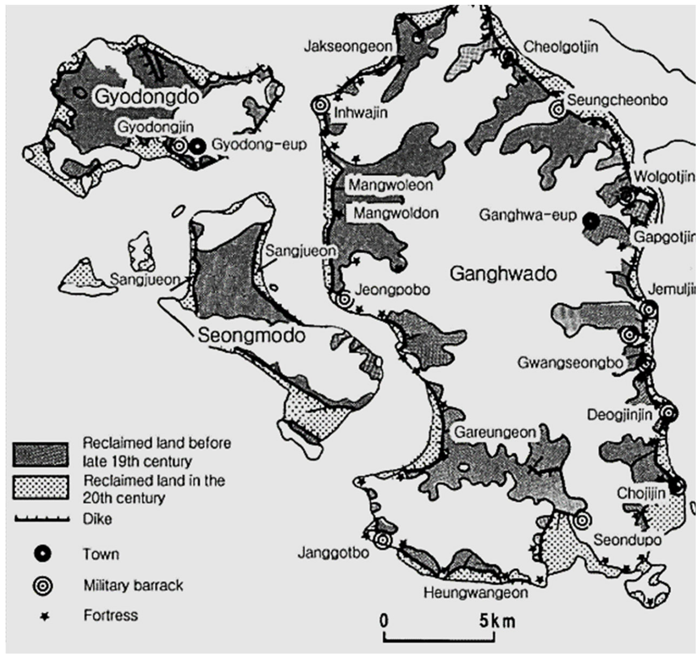
2.2. Rising the Necessity of Ganghwa Dondae: Reclamation in the Goryeo dynasty

Ganghwa Island has long been favorable for reclamation [14]. The background of this reclamation project was the Ganghwa capital of Goryeo. Exactly when people began to live on Ganghwa Island is unknown. Judging from the present Ganghwa dolmens and the Cheomseongdan Altar at Mt. Mani, which is related to Gojoseon, the first Korean kingdom lasted until 108 BCE. Therefore, Ganghwa Island settlements have probably existed since prehistoric times. In the Shinjeung Donggungnyeojiseungnam (Augmented Geographical Survey of Korea) published in the Joseon era, place names such as Baekje Gapbigocha and Goguryeo Hyeolgugun date back to the Three Kingdoms period. The name Ganghwa-hyeon was not used until the reign of King Hyeonjong of Goryeo; when it was promoted to a county (gun) during the later reign of King Gojong (r. 1192–1259) [15]. During King Gojong’s reign, Ganghwa Island was upgraded to Gangdo as a national central base. It was elevated to the status of a capital to thwart the Mongol invasion, as Choi Woo (1166~1249), who was the head of the military regime at the time, insisted on relocating to Ganghwa Island [16].
The Mongolian army was vulnerable to naval battles, as its main force comprised horsemen. In this sense, Ganghwa Island had several advantages. First, it was located downstream at the junction of major rivers, with the waterways forming a means of transport to Gaeseong, the capital of the Goryeo dynasty. As the island was part of the maritime route, it was convenient to impose taxes on Jeolla-do Province, which was a granary. The large size of the Ganghwa Island with its abundant resources made it possible to achieve self-sufficiency to some extent [17]. After the relocation of Ganghwa, Choi Woo ordered the construction of palaces and city walls. He mobilized approximately 2000 soldiers to build a palace in Ganghwa. Based on the records [17], the outer fortress was built before the middle fortress. There are no separate records on the construction of the inner fortress; however, the city walls on Ganghwa Island were demolished to relocate the capital after the Goryeo reconciliation with Mongolia.
Thereafter, the Goryeo court did not build city walls on Ganghwa Island again, and Joseon was founded through a change in government [18]. During the first 200 years of peace after the founding of Joseon, Ganghwa Island did not receive much attention. During the Imjin Wars, Ganghwa Island became a place of refuge for kings, as it did during the Goryeo dynasty. The Annals of the Joseon dynasty refer to Ganghwa Island as an evacuation point in the event of a national crisis. Later on, King Seonjo, Gwanghaegun (r. 1608~1623) explicitly mentioned it as a safe haven and sent his servants to examine its condition [19]. Even during the Manchurian invasion after the Japanese invasion, Ganghwa Island retained its prominence. King Injo (r. 1623–1649) moved safely to Ganghwa at the time of the Jeongmyo Horan (first Manchu Invasion, 1627) where Ganghwa Island served as a major refuge. During the second Manchu invasion, Byeongja Horan (1636–1637), Injo tried to escape to Ganghwa Island through Namhansanseong Mount Fortress [20]. However, the Qing army occupied Ganghwa Island before King Injo took refuge in Ganghwa Island. Although King Injo continued to fight at Namhansanseong Fortress, he was humiliated by the Manchurian king on Samjeondo Island. The Qing army, which failed to attack Ganghwa Island during the Jeongmyo Horan, invaded the place using improved equipment and greater forces during the Byeongja Horan.
The development of Ganghwa Island started when King Gojong (r. 1192–1259) of Goryeo moved the Hwangdo Walled City (Gaeseong) to Ganghwa Island to signal his intention to repel the Mongol invasion. The sudden relocation of the city in 1232 caused people to move to Ganghwa Island. At the time, the population of Gaeseong was estimated to be approximately 100,000, with a considerable number of refugees flowing in as the royal court moved to the Ganghwa area. As the Mongol army had ravaged the entire country, the Samnam region of Chungcheong-do, Jeolla-do, and Gyeongsang-do was devastated, thus making it impossible to receive grain through marine transportation [14]. Ganghwa Island was forced to find a different way of securing food to support this large number of people. According to records of the 43rd year of Emperor Gojong’s rule, he built a dike in Wapo and Jepo to be reclaimed for Jwadunjeon (paddy fields cultivated by stationary troops on the left side) as well as Ipo and Chopo in Yeomha to establish Udunjeon (garrison paddy-fields on the right side) [21]. These fields were walled in, which made land reclamation easier. Consequently, the tidal flat area on the Yeomha side facing Gimpo decreased, the coastline became straight and simplified. According to records of Byeongja Horan’s defense of Ganghwa Island, the Qing army landed in Gapgot, which is connected to the island by the Ganghwa Bridge [22]. On account of the reclamation project for clearing arable land, the distance between the land and the island was reduced, and the Joseon army, which fled to Ganghwa Island during the Byeongja Horan, had to mount a defense in advance. Nevertheless, the Joseon army failed to stop a surprise landing by the Manchurian forces using a raft, and Ganghwa Island was eventually captured. In other words, extensive changes in the coastline caused by the reclamation project lowered the defense ability of Ganghwa Island as a whole (Figure 4). For these reasons, the Joseon dynasty in the 17th century considered the 54 Dondae forts of Ganghwa Island as a realistic alternative to defend the island.

3. Structural Characteristics of Existing Ganghwa Dondae Forts

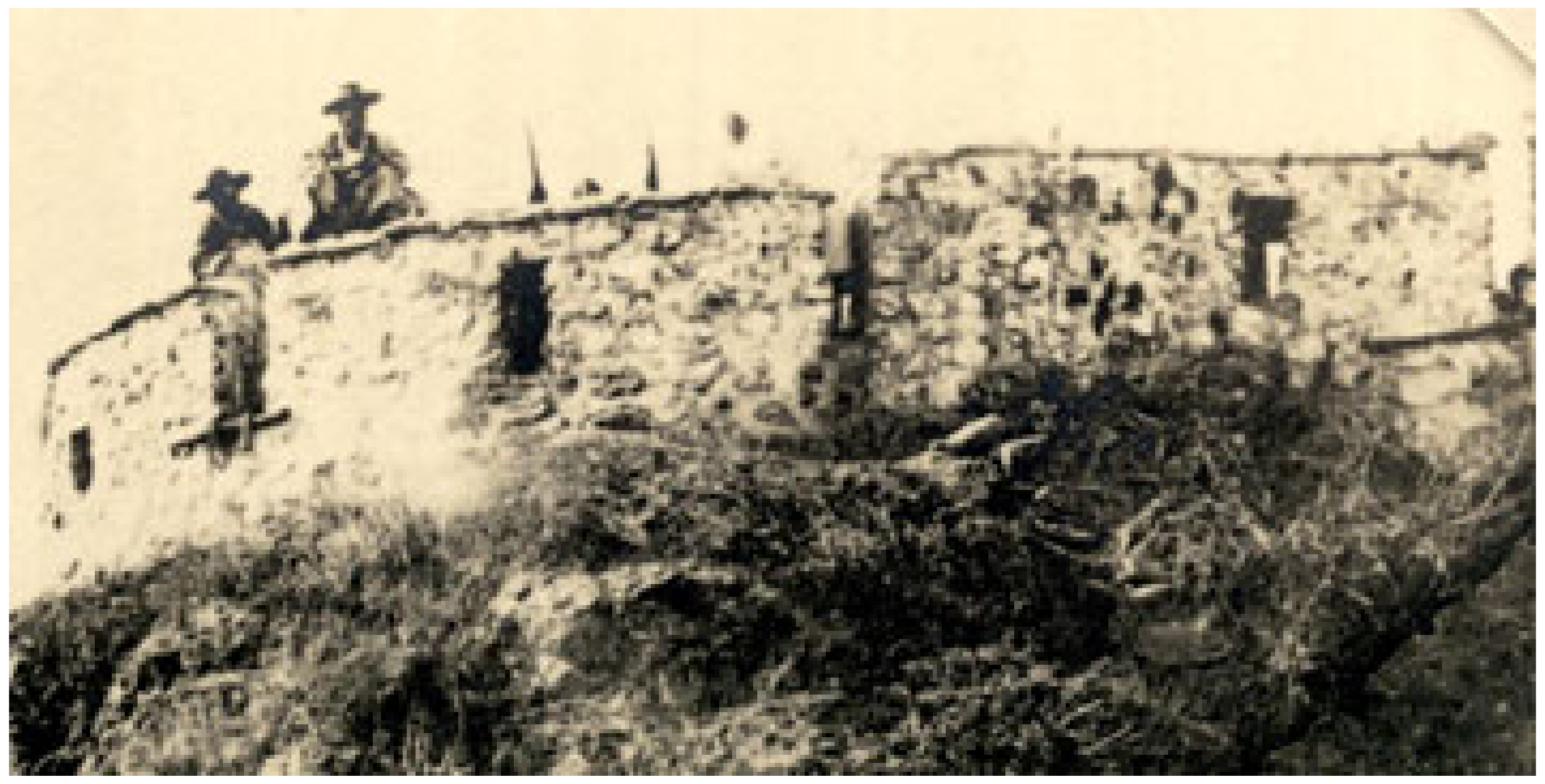
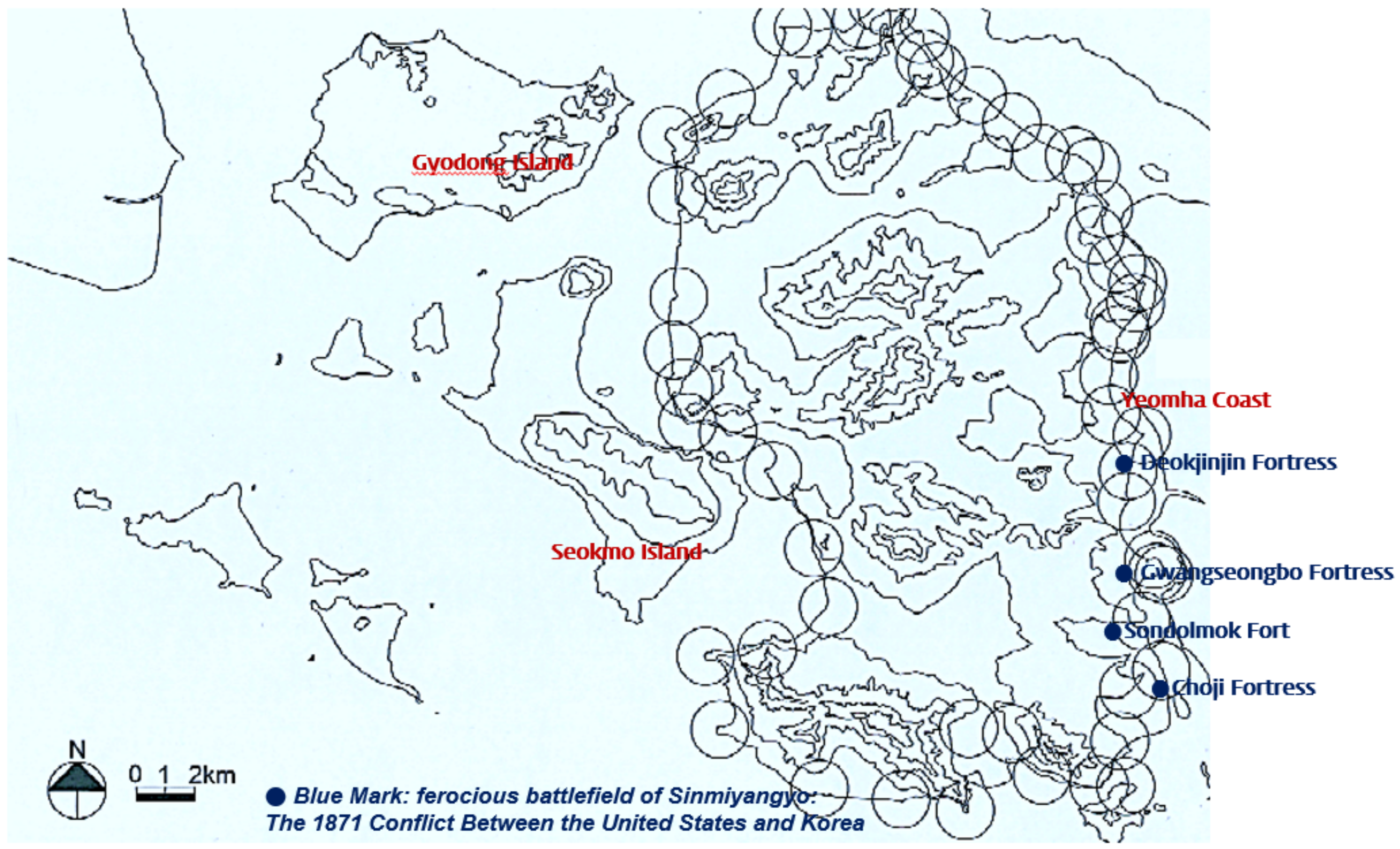
3.1. Discussion and Construction Activities of Ganghwa Dondae

Joseon King Injo (r. 1623–1649) attempted to build and extend the fort based on his experience with the Byeongja Horan, but was unable to do so due to Qing interference [23]. King Hyojong (r. 1649–1659), in particular, advocated the “conquest of the Manchurian area” and planned extensive military training and fortifications. The role of Ganghwa Island as a safe place to protect the court from the Qing’s aggression was further emphasized. As Ganghwa Island’s coastline was known as a good place for ships to anchor, methods of defending Ganghwa Island continued to be discussed [24]. Dondae forts were first proposed during King Hyeonjong’s reign (r. 1659–1674).
On 16 July, the fifth year of King Hyeonjong’s reign (1664), Min Yu-jung, a royal inspector at Ganghwado, reported: “Ganghwado can anchor ships everywhere, so more fortifications should be installed along the coast to support on each other and to prevent enemy invasion” [25]. This assertion is consistent with the function of the Dondae forts in Jixiao Xinshu. The Joseon version of Jixiao Xinshu, which already had a tremendous influence on Joseon military practices, was redistributed as a textbook of practical tactics on 25 August of the same year [26].
In the fourth year of King Sukjong’s reign (r. 1674–1720), Minister of War, Kim Seok-ju, visited Ganghwa Island, selected locations for Dondae forts and Jinbo fortresses, and developed the Gangdoseoldoncheosobyeoldanjiangdo (Survey Report for Site Feasibility) [27] along with a map showing the entire Ganghwa Island. Based on this report, on 4 November of the same year, a building plan was prepared based on Gangdoseoldoncheosobyeoldanjiangdo (Implementation Guidelines for Installation of Ganghwa Dondae) as a guideline for construction [28].
Full-scale construction began in the fifth year of King Sukjong (1679). According to Seungjeongwon Ilgi (Journal of the Royal Secretariat) and Bibyeonsadeungnok (Records of the Border Defense Council) [28], Buddhist monk troop workers, comprising 2800 people from Jeolla, 1800 people from Chungcheong, 500 people from Gangwon, and 400 people from Hamgyeong, participated in the project. On 26 February, a roll call was conducted in Tongjin-hyeon. By 2 March, the workers dispatched to each province were in place to start construction [29] (Table 1).
First, workers were sent to Ganghwa Island. Originally, this was supposed to be completed in 40 days. However, it was delayed by another 40 days due to technical issues, such as material procurement and transportation. Dondae construction was completed on 23 May 1679 by a total of 8900 monk troops and 4262 public troops deployed alternately [3].
Ganghwa Dondae initially planned to include 49 forts during the reign of King Sukjong, but only 48 forts were built. Subsequently, additional forts were constructed as needed. A previous study [30] has identified a total of 54 forts built.

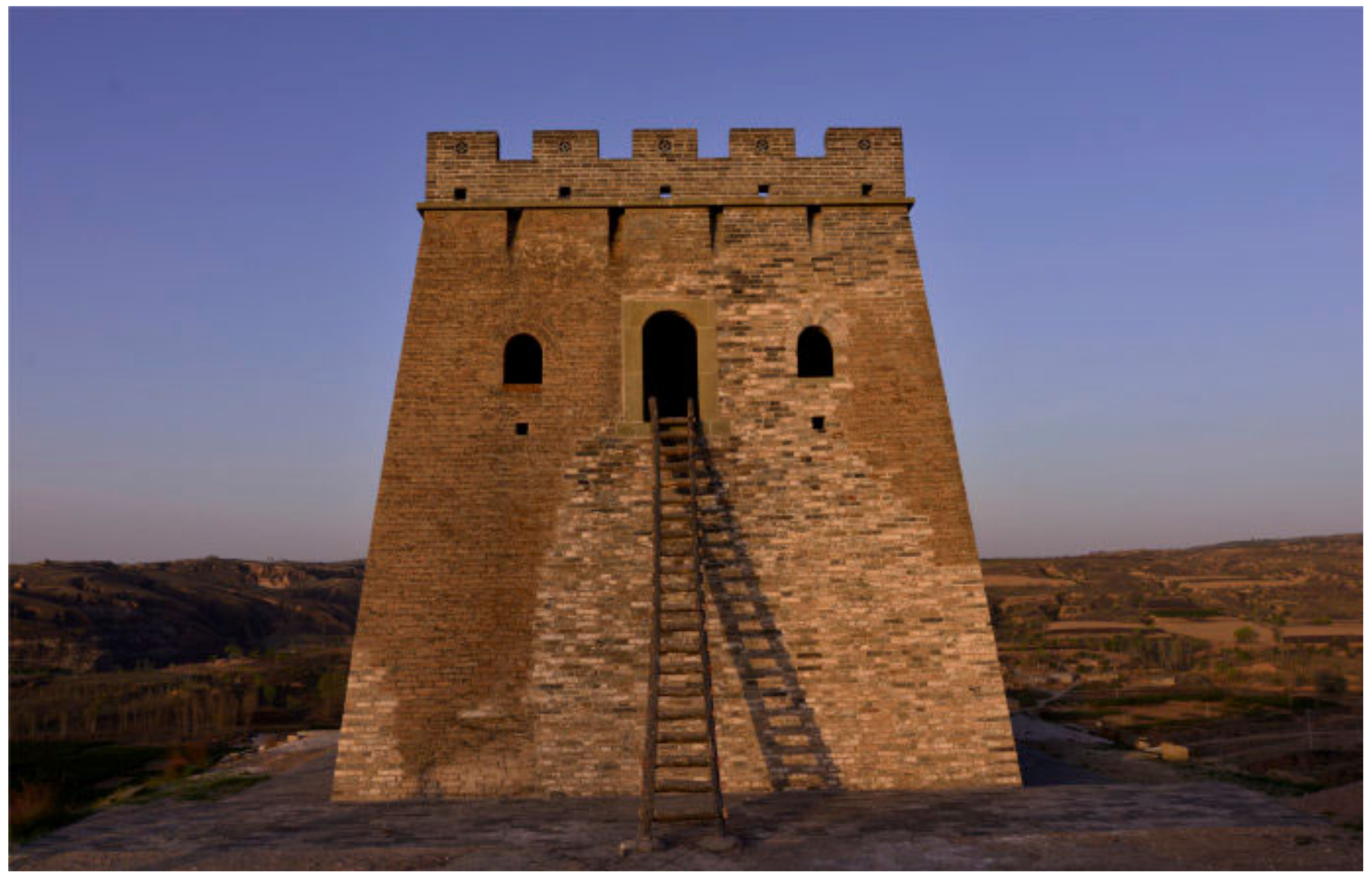
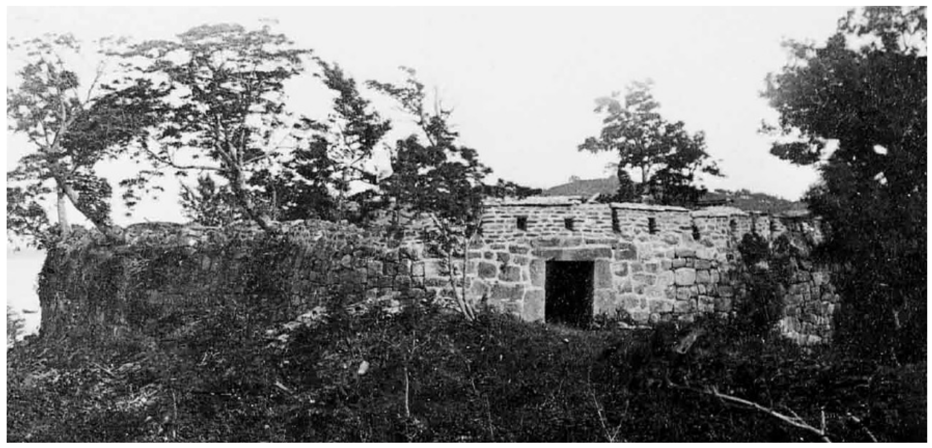
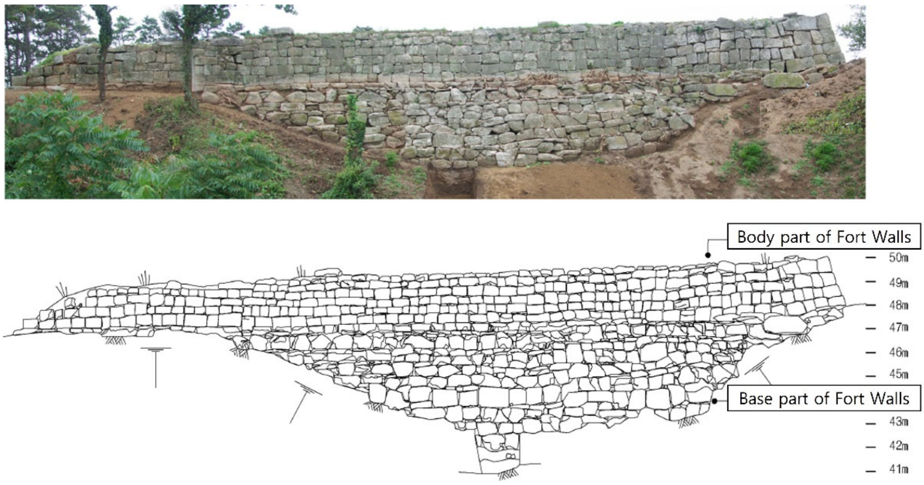
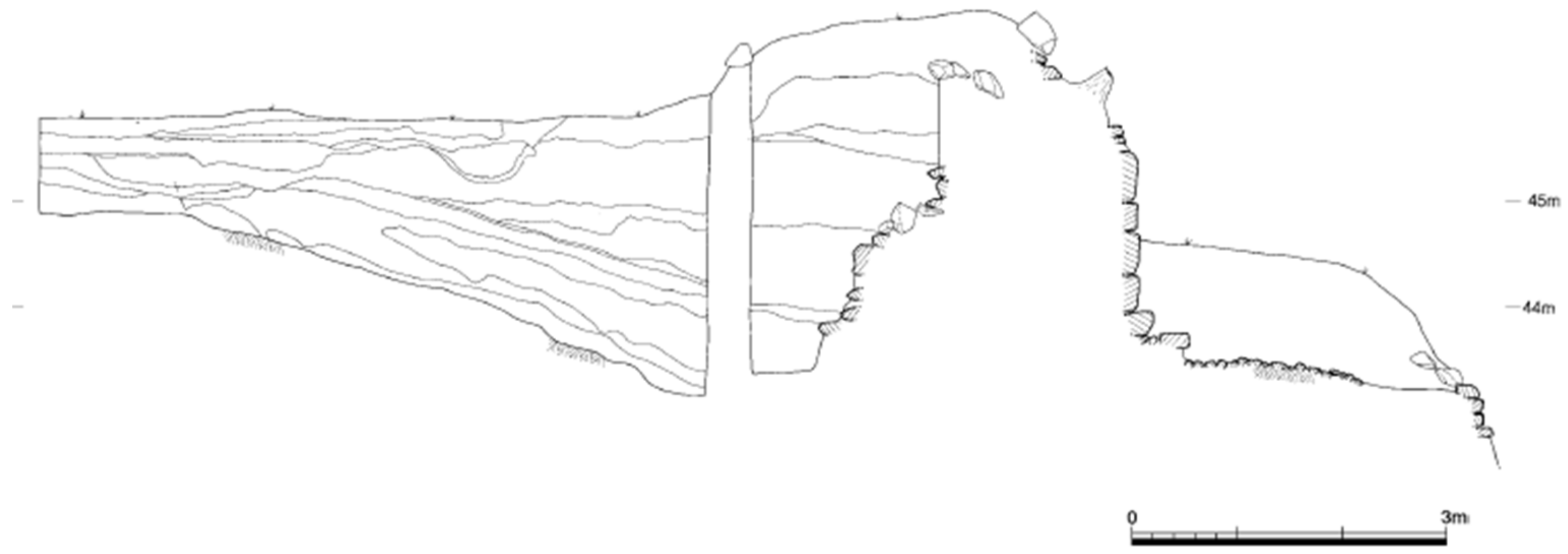
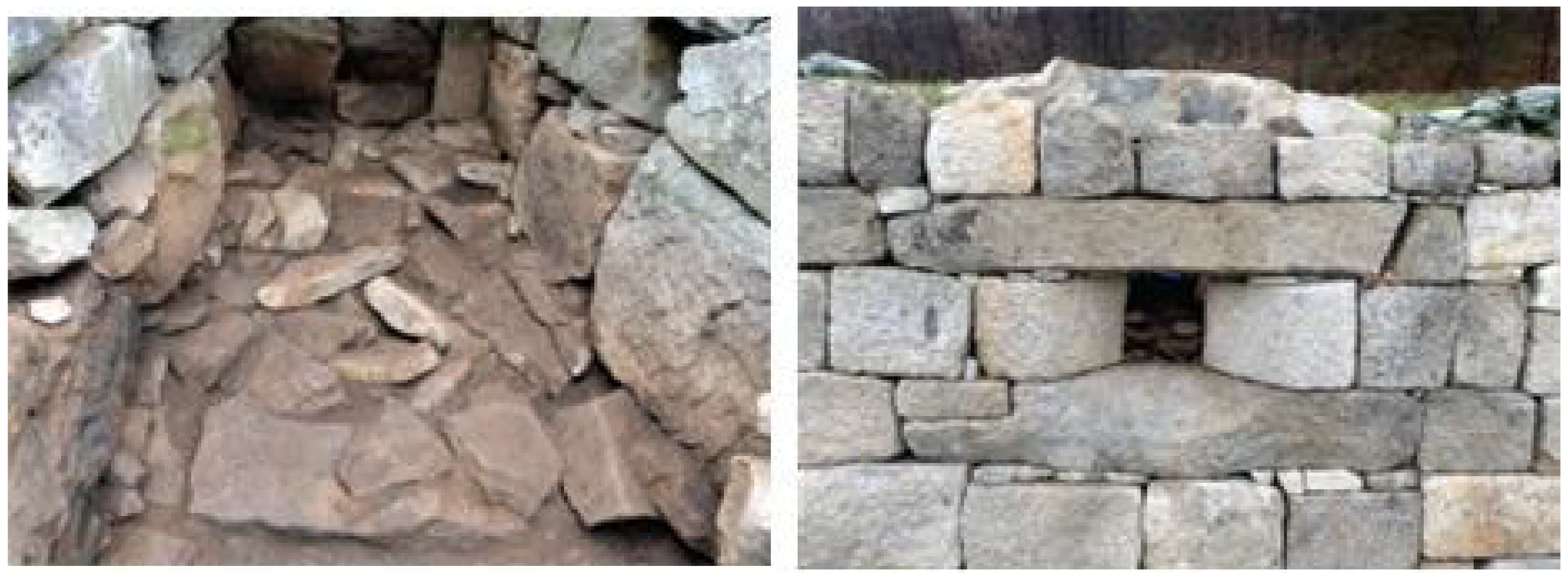
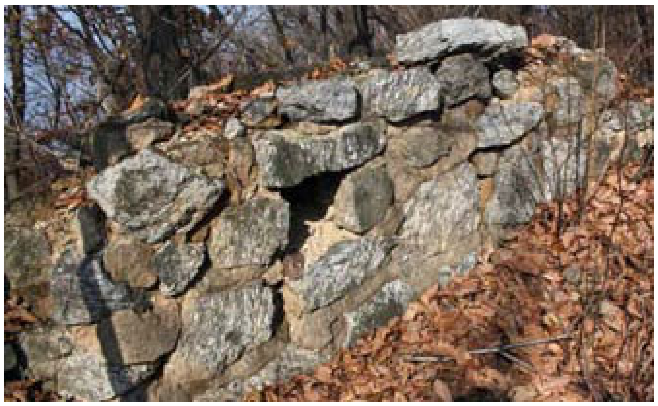
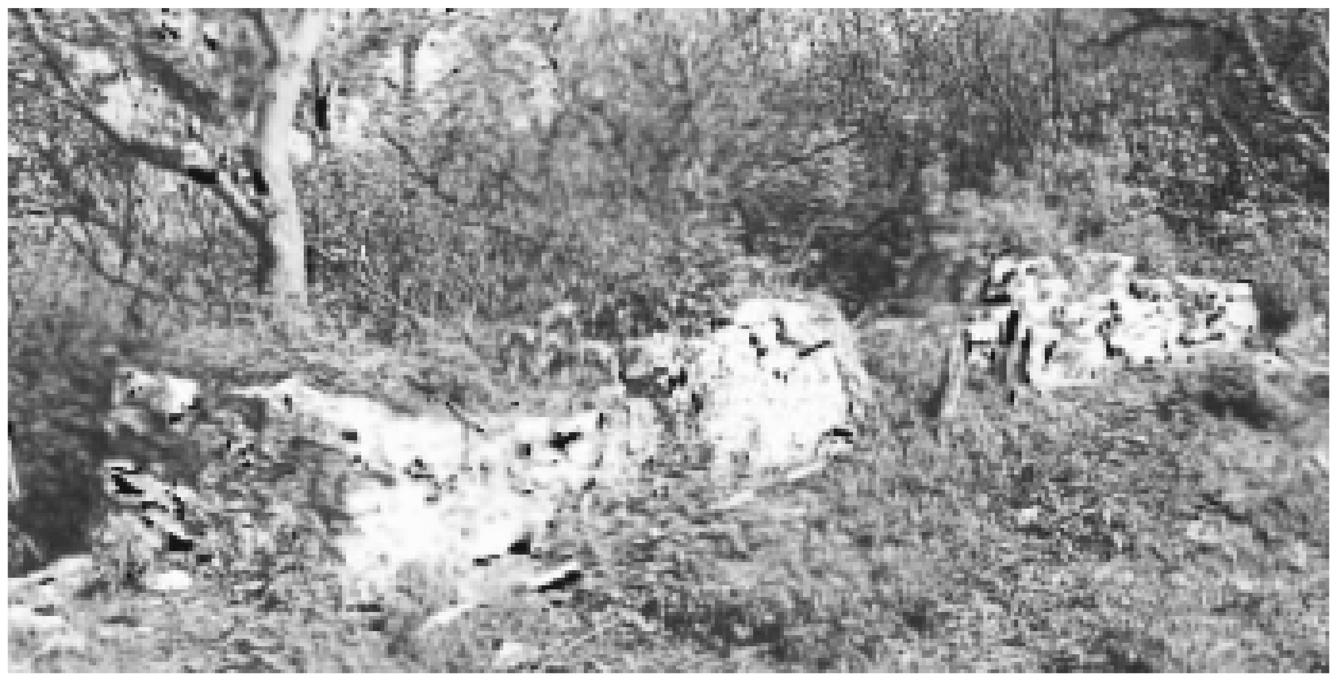
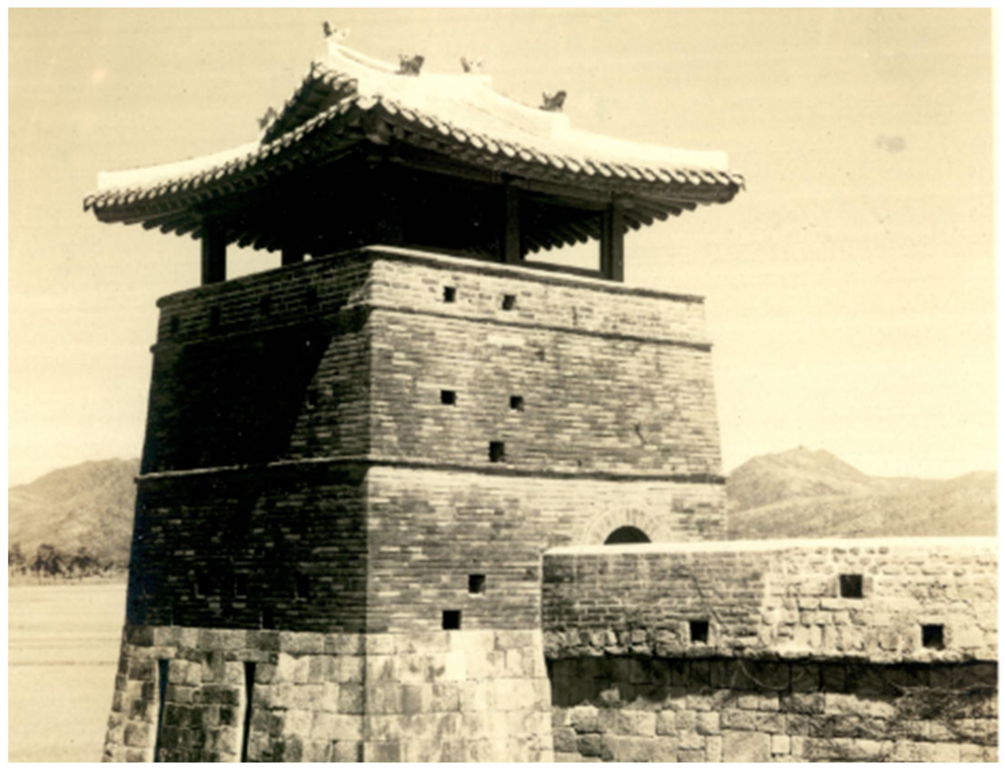
3.2. The Remaining Dondae Structures

Ganghwa Dondae forts constituted a small military base. Their structural composition can be divided into three main parts: the base, the body, and the crenellation. First, the base work was completed after exposing the construction area to the bedrock layer and before building the upper walls, comprising the body of Dondae forts.
Most forts were built in mountainous areas with slopes. To match the height of the site, the base was built using stones or an earth-and-stone mixing method to meet the outer perimeter of the fortress. The foundation stones were installed at the base, and depending on the inclination, they were either placed directly on top of the rock or avoided entirely with the surface stones deposited directly. For forts built on steep slopes, such as the Choru Dondae fort built in 1720, rubble was placed both inside and outside the fortress to prevent the soil from flowing out [31].
The bodies of such ancient Korean forts comprised surface stones and were constructed using one of the following two methods: walls built with piled-up stones on both sides or walls built with piled-up stones on one side. However, an investigation of the extant ruins of these forts reveals that their gates and fortifications had to be narrow considering the use of the inside premises of the fortresses. Stones were usually used for Dondae forts, particularly surface stones trimmed into rectangles or squares. Regarding the cultivated land to ensure food security for troops stationed in frontier areas or military strategic points, only some of the dunjeon fields mentioned in the historical records have been archaeologically excavated to date.
The large surface stones used in Gyeryong Dondae fort are about 110 × 70 cm and 60 × 75 cm in size, while the smaller ones are about 40 × 45 cm in size (Figure 5). The piled-up method employed is different on the outside and inside of the fort walls. The outer part of the fort walls comprises piled-up stones with stretcher bonds based on continuous courses of masonry units. This method is the simplest and most widely used in fort constructions, featuring precisely interlocking and backing stones. Conversely, the inner side of the fort walls is built through broken rangeworks using natural stones. The thickness of the fort walls is estimated to be about 4.3 m in the north and 5.9 m in the south, based on the east walls in good remaining condition [31].
For the outer wall of Choru Dondae, large square stones 40–80 cm long and 30–55 cm high were used as surface stones (Figure 6). The method of piling up surface stones was based on the piled-up stones not being of uniform height within each course layer—they were not consistent because the height of each face stone member was different. As with Gyeryong Dondae, the structural strength was increased by ensuring that the interlocking stones were placed very close to each other through chamfering after grinding. The height of the fort walls from the upper part of the foundation stone to the lower part of the crenellation was about 2.5 m, and the surface stones were composed of seven steps. The third and fourth steps of the lower part are almost vertical; however, they are piled up in a slightly inclined way toward the upper part [31].
As for the surface stones used in Geonpyeong Dondae, those sized 20–30 cm with a height of 15–25 cm were mainly used. A larger sized stone, 40 to 65 cm long and 25 to 30 cm high, was used around the gate. Similar to the forts discussed above, the outer surface of Geonpyeong Dondae was built using a stretcher bond with a uniform course. However, interlocking stones were used to strengthen the structure between the stones. The interior of the fort walls was created using surface stones in a non-rangework course. The structure of the body was also stacked at a slightly inward tilt as it went up from the lower part to the top.
In the case of Geonpyeong Dondae, the slope of the site is very different from the east to the west. The north and south walls were built according to the slope, and the remnants of the north wall are up to 13 tiers and 9 tiers/4.5 m and 1.9 m high in the west and the east, respectively. For the outer part of the south wall, a large rectangular stone 78 to 120 cm long and 36 to 40 cm high was used for the lower part, and a relatively small stone 36 to 60 cm long and 24 to 36 cm high was used for the upper part. The inner side was built with broken rangework without foundation stones [31].
The east wall of Garisan Dondae fort has collapsed completely, making it impossible to determine its shape. Some of the masonry course rows remain inside, and the inside of the fort walls are filled with rubble. According to estimates based on fort remnants, Garisan Dondae was laid entirely from the back toward the outer walls, thus, it was either built using piled-up stones on the one side or adding gun emplacements. On the north, west, and south sides, the fort wall rotates in an oval shape, but again, the outer wall is in a state of collapse except for the first and second steps at the bottom. To compose the fortress wall, like other places, masonry built of stones 34–70 cm long and 31–45 cm high was used, as masonry built of stones of the same height within each course and the walls were piled inwards. The structures of other military forts are generally very similar to those of the aforementioned forts [31].
Above all, Ganghwa Dondae has unique structural features that are different from that of fortress walls in the pre-17th century. For instance, an embrasure was created separately at the lower part of the fort walls to function as a cannon emplacement. This reflects a change in military tactics after the Byeongja Horan (Manchurian invasion) in 1636, as before the Byeongja War, outpost structures were established with a large-scale artillery battle in mind.
There were 2–4 cannon emplacements in each existing military fort. They mostly face the shoreline outside the island, and their size and shape are usually similar. The emplacements consist of a breech loading area and an embrasure. The breech loading area is about 1 m wide, 4 m long, and 1.5 m high. The embrasure narrows as it moves outward and is both 35 cm wide and long (Figure 7). Considering the specifications of the Frankish guns used at the time, it would be considered an appropriate size. On the left and right sides of the embrasure, stones were slanted from the inside to the outside so that the flames and shells could be emitted effectively, and lime was applied between the piled-up stones of the embrasure. Wide and thin stone tiles were laid on the emplacement floor, creating a special chamber for storing shells. Such fort structures have also been confirmed in Jakseongdon, Samandon, Mangyangdon, Janggotdon, Bukilgotdon, and Migotdon [31].

4. Vernacular Architectural Characteristics and Construction Techniques of the Dondae Fortifications

4.1. Application of Systematic Construction Plannings and Techniques

Kim Seok-ju’s Gangdoseoldoncheosobyeoldanjiangdo [35] and the river capital report in Bibyeonsadeungnok [28] are significant records of the Dondae construction project in Ganghwa Island.
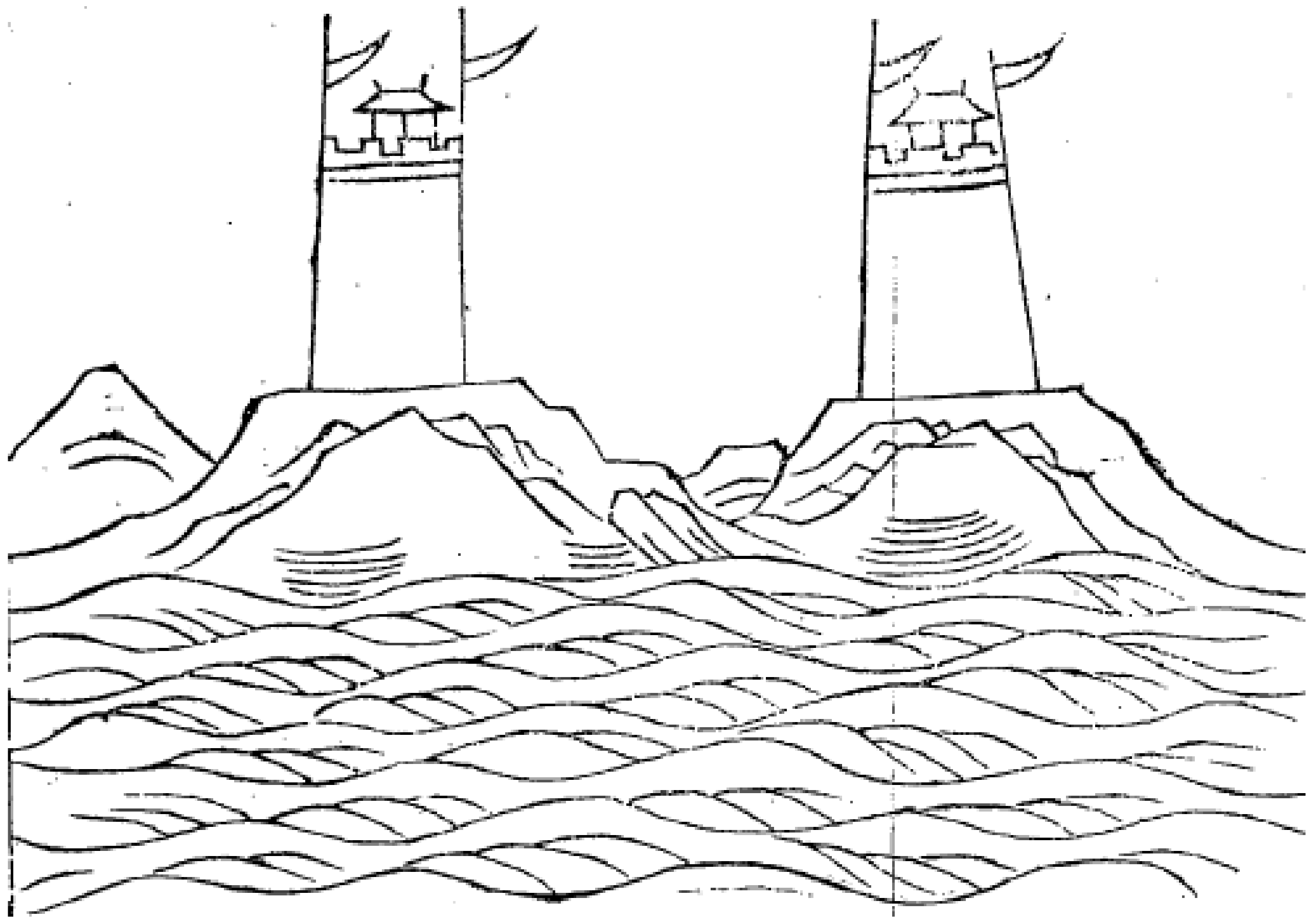
The fourth is the monk’s pavilion. The front and right sides are steep cliffs. Because the mountain was used as a battlement, the front was round, and the rear was curved. It is connected to Manghaechi to the west and Yeomjuu to the south.
The eighth is the dragon ferry. There is a hill on the left, so it is square because of the topography. It is connected to the Garisan Mount in the north and Yongdanggot Cape in the south.
The fourteenth is Sonseok Port. It is circular owing to its topography. It connects to the Gwangseongbo Fort in the north and the Deokjin Fort in the south.
In Gangdoseoldoncheosobyeoldanjiangdo, the name and location of the 49 Dondae forts constructed during the early period, environmental factors surrounding them, and their connection with other adjacent forts were planned in the same way as described above. The Gangdodondaeseolchukjeolmokjiangdo listed in the Bibyeonsadeungnok is divided into three parts: (1) preface that describes the purpose of the Dondae installation; (2) the regulation proposal that sets the battlement height of the Dondae and a hole drilled in a trench or wall for firing artillery; and (3) content on procurement of materials. The detailed size specifications for the Dondae forts are as follows:
The number is set at forty-nine Dondae Forts, and in the Dondae system, battlements are built along the mountains where there are mountains, and when a fort is built on a flat land, its height is 3 zhang, and the depth of the base is 3 zhang 5 cheok long, and the width of the front face should be 2 zhang and 5 cheok. The crenellations should be 6 zhang high, 3 zhang deep, and 9 zhang long, with two cannon-holes in the front, each on cannon-hole on the left and right, and the perimeter is based on 10 bays in four directions. However, depending on the topography, the Dondae Forts should be square or circular, straight or U-shaped, and in core areas where in case there are many guards, the scale of the fort should be appropriately enlarged.
Likewise, the necessary building materials, such as material requirements, necessary workforce, food quantity for the workforce, materials for military forts, material transportation, and transportation equipment were arranged in detail. The construction details are summarized in (Table 1).
Thus, the Ganghwa Dondae forts were created through a comprehensive plan that reflected the site conditions (as with modern architectural designs) and systematically calculated the materials required for process management as well as their methods of procurement. Moreover, the installation of the forts demonstrates the employment of the measurement unit system, standardization of prescribed height and depth dimensions based on a written manual, quantity management of stone and wood used in each Dondae fort, transportation methods applied for construction, determination of the means and size of material supply, and determination of the number of personnel and materials suitable for the construction period and scale. These factors were specifically and universally applied to systematically perform sustainable repair and maintenance. Concerning the Dondae forts, individual size, material use, and arrangement shapes were determined according to the characteristics of the topography and importance of the location. The principles of universality and locality were used equally in the construction of the Dondae architecture.

4.2. Sustainable Use of Weights and Measures Techniques in the Early Joseon dynasty

The yeongjocheok (construction measurement unit) was estimated using the building remains to confirm the applied building code of Ganghwa Dondae. As a detailed methodology, the standard measurement unit was confirmed with a focus on comparable perimeter lengths in the records of Yeojidoseo (Chorography of Korea in the Joseon period) [36] and measured records. Further, the Dondae forts were built before the modification of weights and measures in the late Joseon era. Therefore, by checking the yeongjocheok of Dondae forts, this study determined whether Joseon builders at the time of the Dondae construction followed the norms of the early Joseon dynasty or adapted swiftly to the changes in building measurement units in the late Joseon dynasty.
A striking characteristic of the entire scale used in ancient architecture is that the construction measurement units appropriated for each period were different. Records of the introduction and correction of weights and measures existed even during the Joseon dynasty. However, in the Joseon dynasty, the rule of measurement units was specified in law by Gyeongguk Daejeon (Joseon National Code) [37], which was produced and disseminated by the royal court. Compared with other periods, many buildings date to the late Joseon Dynasty; therefore, the deviation of yeongjocheok (rulers for basic construction) estimated by previous researchers was much smaller than those in other periods. The unit cheok was used in Korea until the metric system came into use. The cheok was divided into jucheok (Zhou-foot rulers), pocheoncheok (rulers for surveying frontier defenses), hwangjongcheok (rulers for manufacturing and tuning musical instruments), and yeongjocheok.
Yeongjocheok and jucheok were regulations upon necessary weights and measures to understand fortress architecture. In general, yeongjocheok was a module for determining member dimensions and a unit of length used for proportional application when building military forts. However, as an ancient measurement unit of length and width to indicate the circumference and large distance of a fortress wall, bo was utilized in Joseon era [38]. The bo was the upper measurement unit of jucheok, with one bo equaling six jucheok [39]. When constructing Dondae forts, it is necessary to understand the relationship between jucheok and yeongjocheok to determine the length of the circumference according to the yeongjocheok [40]. The weight and measure standard was stipulated in the Gyeonggukdaejeon gongjeondoryanghyeong (Regulations upon Weights and Measures in the section on manufactures from the Grand Code of State Administration) [37], written during the early Joseon dynasty. To summarize the ratio, jucheok corresponded to “0.606 hwangjongcheok, and yeongjocheok corresponded to 0.899 hwangjongcheok”. Consequently, these proportional values were the same numerical values that appear similarly in metrological artifacts. Based on the existing relics, if the hwangjongcheok was approximately 34.48 cm [41], the jucheok was approximately 20.89 cm and the yeongjocheok was approximately 31 cm. Most of the ruler’s relics based on yeongjocheok were made of wood, and all those found were corrupted. Considering the limitations of pre-modern technology, the above-mentioned calculation value fell within an inch of the estimate of previous studies [40].
Therefore, the one bo yeongjocheok used in the early Joseon dynasty was six jucheok, and the proportional value of 4.04 yeongjocheok was used for construction works. In the Hwaseongseongyeokuigwe (Completion Report on the Construction of Hwaseong Fortress) [38], written during the late Joseon dynasty, the ratio of bo and yeongjocheok differed from that of Gyeongguk-Daejeon. According to Hwaseongseongyeokuigwe’s Gwonsu Doseol (Diagrammatic Treatises), “one bo was six jucheok, which is the same as the early Joseon dynasty. However, for yeongjocheok, the proportional value changed to 3.8 cheok.” It shows that the ratio of yeongjocheok to jucheok changed between the early and late Joseon Dynasties.
The relevant military forts, name, location, circumference, and length are included in Yeojidoseo [36], which was created during the reign of King Yeongjo (r. 1724–1776), and Ganghwabuji (Geography of Ganghwa) [42], which was published during the reign of King Jeongjo (r. 1752–1800). This study estimated and analyzed the yeongjocheok by comparing the results of the actual survey with the Yeojidoseo record, which is the closest period after the construction of the Dondae forts in Ganghwa Island. Dondae forts that were too damaged or restored without knowledge of their original form were excluded from analysis on the estimation of standard measurement units to build the forts between Hwaseongseongyeokuigwe 1 yeongjocheok (cm) and Gyeongguk Daejeon 1 yeongjocheok (cm) (Table 2). The Yeojidoseo is a reliable documentary source that mentions the perimeter of Dondae forts recorded in bo measurement units. The measured value using the modern metric system was divided by the circumference of the bo unit to obtain the value of one bo and converted to the yeongjocheok unit in the early and late Joseon Dynasties. To understand the operation of vernacular construction methods to maintain the regular scale employing the regular size of materials to build the forts, this study noted that these forts applied early yeongjocheok systems by comparing the cheok-unit measures.
Overall, the yeongjocheok value converged to approximately 20.5 cm [±2 cm, error range of 1 chi], which was in jucheok. However, when converted to yeongjocheok units of measurement, the result values converged more in the section of approximately 30.5 cm [±3 cm, error range of 1 chi]. One jucheok converted to six bo and calculated using the modern metric system amounts to 123 cm. If this is converted back to yeongjocheok units, it amounts to 4.03 bo. This estimate confirms that this was a different numerical value from the 3.8 cheok mentioned in Hwaseongseongyeokuigwe’s Gwonsu Doseol. In other words, the figure is closer to 4.04 bo calculated when converted to yeongjocheok in the early Joseon dynasty, as mentioned above (Table 2).
The ratios of jucheok and yeongjocheok in Gyeongguk-Daejeon and Hwaseongseongyeokuigwe differed by 4.04 yeongjocheok and 3.8 yeongjocheok, respectively. Based on a survey of the forts, most Ganghwa Dondae forts were vuilt using a framework of 4.04 yeongjocheok units of measurement mentioned in the Gyeongguk-Daejeon, although they were built during the regime era of King Sukjong.
These results demonstrated that Ganghwa Dondae was closer to the norms stipulated in Gyeongguk Daejeon published in the early Joseon dynasty than those of the Hwaseongseongyeokuigwe, which was written in the 18th century. The yeongjocheok of Dondae faithfully sustained 15th century norms of weights and measures promulgated during the Sejong period of the early Joseon dynasty until the early 18th century.
Moreover, the one-cheok (30.5 cm) measurement unit obtained through the above-mentioned analysis of yeongjocheok was applied to the measurement regulation presented in Bibyeonsadeungnok, and subsequently, the measurements were rearranged and compared in modern scale units (Table 3).
First, the size of the fort walls, including crenellations mentioned in Bibyeonsadeungnok, was identified, and the scale of these walls was analyzed through comparable examples. Considering the heights of the existing fortress walls built during the Joseon era, Bukhansanseong Mountain Fortress is estimated to be 4~6 m high, Namhansanseong Mountain Fortress, 3~7 m high, Hwaseong Walled City in Suwon, 4~6 m high, and Hanyangdoseong Walled City in Seoul, 5~8 m high. Thus, examining other extant fortresses reveals an absence of fortress walls 9 m high, except for that of Hanyangdoseong. Therefore, it is incorrect to regard the expression of the castle as fort walls which usually used in Korean architecture.
Thus, the meaning of seongcheop is situated in context by re-interpreting the original text mentioned in Bibyeonsadeungnok: “Dondae fort is built where there is a mountain, and the mountain should be used as a seongcheop. Conversely, if the fort is built on a flat land, walls should be built on the site. Here, the standard for the height of the fortress wall is about three.” In other words, there was a proviso clause that, when building the Dondae fort on a mountain, the height of the fort walls should be commensurate with that of the mountain. Therefore, the measurement regulation for the height of 3 jang (zhang) was for building a military fort on a flat land.
In other words, the “regulation that the fort must be built at a height of at least 3 jang (30 cheok, about 9 m) on a flat land” can be reinterpreted to mean that an elevation corresponding to a height of 3 jang (9 m) must be created in a mountainous area. Based on this, the elevation of the sites within the forts was analyzed within the identifiable range [31]. Consequently, the forts were constructed at least 10 m above sea level (Table 4).
Similarly, the term seonggakwi is also analyzed as seongcheop (height of fort walls). In general, seonggakwi means crenellations, which are additional low defensive walls installed on the main fortress walls. However, similar to the analysis of the height of fort walls, examining the crenellations in other existing fortresses built in the Joseon era reveal them to be an average of 4 cheok (about 1.2 m) in height. The 1.8 m high battlements mentioned in Bibyeonsadeungnok was not found in Ganghwa Dondae forts.
Bibyeonsadeungnok states, “Seonggakwi is 6 cheok high, 3 cheok thick, and 9 cheok long. In a military fort there are two embrasures on the front, and one embrasure on the left and right, respectively.” In the Dondae, the embrasure is located under the crenellation. Considering these structural features, the scope of “seonggakwi” in Bibyeonsadeungnok could be regarded not only as the crenellation generally used in other forts, but also as the lower body part where the emplacements were located.
Previous studies have confirmed whether the dimensions of the relevant area correspond to 1.8 m. The height is actually 1.62 m based on the actual survey of the emplacement at the Bunori Dondae fort [30]. However, if the height of the first stage of piled-up stones excluded from the top of the emplacement is added, it amounts to the approximate value of 1.83 m specified in Bibyeonsadeungnok. Comparing the dimensions of the building confirm that the dimension regulations prevalent at the time of the construction of Ganghwa Dondae were actually applied.

4.3. Construction Techniques Applied to Ganghwa Dondae

The early 48 Dondae of Ganghwa were planned and realized by Kim Seok-ju, a vassal/ civil official during the reign of King Sukjong. Kim served as Byeongjopanseo (defense minister) during the time of Daejehak (Chief Scholar of Hongmungwan). His insights represent military knowledge of the literate class during the late Joseon dynasty. A military perspective and rationality can be found in Dondaepilchuksunsimhuseogye [36], a post-construction report written by Kim Seok-ju. The military rationality of Ganghwa Dondae is reflected in the arrangement between Dondae forts and yeojang crenellations. First, the yeojang battlement was a characteristic of the Ganghwa Dondae. The battlement is a low wall built to avoid arrows or bullets from the enemy [43]. The low and shallow crenellations or battlements were all called yeojang. Additional elements were pyeong-yeojang (battlement without a stone base), cheolja-yeojang (rectangular shaped battlement), and banwonhyeong-yeojang (semi-circular crenellations) depending on their shape. These were further divided based on material, such as natural stone battlement and stone crenellation. However, as there are no completely preserved yeojang (battlements) in their original form in the current Ganghwa Dondae, their appearance is visualized from remains and photographic materials. The crenellations built during the reign of King Sukjong reflect the characteristic appearance of the 18th century, with three outer walls as auxiliary fortification (Bongamseong, Hanbongseong, and Sinnamseong) and five Oeseong (extended defensive walls), in addition to Namhansanseong Mountain-Fortress and Bukansanseong Mountain-Fortress, among others. The Bongamseong Walls (1686) were particularly suitable as a comparison group, as their construction period was closest to the year when Ganghwa Dondae was built in 1679. At the time, they were divided into flatland-yeojang and inclined-yeojang crenellations, which depended on topographical conditions, wonchongan (holes at the end of merlons), and geunchongan (middle hole of merlons). The crenellations of Bongamseong Fortress used natural stones and bricks [44] (Figure 8).
There were no well-preserved yeojang crenellations in Ganghwa Dondae; however, some cases with remains in the lower part were confirmed. Regarding the materials used to make yeojang parapets, the Bibyeonsadeungnok states: “There are many large and large boulders available at Maeeumdo” and “The battlement was supplemented with bakseok. They have been utilized professionally by Maeumdo Island.” Based on these records, Ganghwa Dondae’s yeojang was made using the bakseok flatstone from Haemyeongsan Mountain in Maeeumdo (Seongmodo). Bakseok refers to roughly hewn granite stone slabs (Figure 9).
Photographic data of Gapgot Dondae presented in Japanese at the time of the Ganghwa Treaty (1876) revealed that the yeojang battlements were different from those of existing natural stone or jeondol (burnt bricks). The yeojang of forts was built using bakseok, which is vernacular stone (not smoothly hewn stone) mainly produced in the neighboring territories of Ganghwa Island. With the development of cannons, standardization of stone members was accomplished in the repairs and extension of existing stone walls (Figure 10). During their construction of King Sukjong, stone elements were standardized in terms of size and made into blocks, shifting from the conventional use of natural stones in the early Joseon dynasty. Thereafter, from King Yeongjo’s reign, an attempt was made to build the fort using burnt bricks. During the reign of King Jeongjo (r. 1752–1800), burnt bricks were systematically used throughout the Hwaseong City Walls. The technique for burning bricks was introduced in the Doseol of the byeongnyo (kiln to burn bricks) in the Hwaseongseongyeokuigwe: “to burn bricks, one firstly has to build a kiln shaped like a great bell” [45]. In this respect, the bakseok-stone battlements as a vernacular construction material reflected a transitional from natural stones to burnt bricks.
The regularized process management that began with the Ganghwa Dondae was replicated in the construction of other walls, including Namhansanseong, Bukhansanseong, and Hwaseong walls [Figure 11]. The use of vernacular construction materials, such as bakseok stone, shortened the construction period of the fortress. As the crenellations were a consumer product that had to be replaced continuously, using easily available materials was a good solution for sustainable maintenance. Constructing 48 Ganghwa Dondae during the reign of King Sukjong in the 18th century was an experimental attempt, and it is meaningful in that Dondae Forts set up a system of vernacular construction methods and maintenance.

4.4. Millitary Rationality for Range and Fire Network of Cannons Employed into Ganghwa Dondae

Kim Seok-ju considered the Frankish cannon as the main military device for the arming of Dondae and strove to architecturally express its characteristics [47]. The Frankish cannon was originally used in Mediterranean Europe. It is called a breech-loading swivel gun in the Western world. The name reveals the characteristics of the artillery in question. The breech loading meant that the user loaded the ammunition (cartridge or shell) via the rear (breech) end of the weapon’s barrel. The swivel was a rotary type that could change direction, while the gun was a direct fire weapon. This type of weapon was used as a small artillery for close-range warfare [48]. The Frankish cannon was first used in Korea by the Ming army in the Battle of Pyongyangseong during the Japanese invasion of Imjin. After this battle, Lee Duk-hyeung reported this activity to King Seonjo. After the Imjin War, the Frankish cannon was produced locally in Joseon and used as their main cannons until King Gojong’s reign [49] (Figure 12).
Frankish Bulranggi cannons Numbers 4 and 5 were mainly used in Ganghwa Dondae, with specifications of a 1 m barrel, and a caliber of approximately 40 mm for the former and a barrel length of 80 cm and a caliber of approximately 25 mm for the latter. Although there are no historical records that accurately record their range, based on Chinese examples, it is estimated that the range was approximately 1 km. As there was a gunsight and a front sight as well, aiming was easy and accuracy was high [51]. The distance between Dondae forts was recorded in Yeojidoseo and Ganghwabuji and estimated to be 2010 bo steps (approximately 2.5 km) based on Deokjindon and Sondolmok Dondae. On modern maps, the shortest distance between these two places by foot is 2.4 km, and the straight-line distance is approximately 1.5 km. Judging from these results, the arrangement of Dondae forts did overlap Frankish cannon’s firing radius. Assuming this scope as the radius, the mutual disposition along the hills made it possible to defend Ganghwa Island. In other words, Dondae forts were located within striking distance of each other’s cannons. However, in some cases, the distance between Dondae forts was shorter than the cannon range. On the side of the Yeomha coast, which can enter the lower reaches of the Han River, the gap between hills is denser. Considering the Shinmiyangyo bombardment cases, it seems that the spacing was artificially adjusted according to its importance (Figure 13).

5. Conclusions

This study attempted to interpret the architectural properties of Dondae forts through definitions of measurements, the origin of forts, and the characteristics of extant ruins. Most of the hills are in extremely poor condition, and there are no architectural relics that remain in their original state of use during the end of the Joseon dynasty. Reconstruction of Ganghwa Dondae began in the 1970s; however, based on the records at the time of designing the forts, continuous maintenance was not possible. At the time of reconstruction, there were no determined sustainable conservation principles, as the focus was on maintenance for tourism of historical sites. In the 1970s, the Park Chung-hee administration, which faced crises at home and abroad, emphasized overcoming the national crisis, promoting the slogan of “chonghwa-dangyeol (unifying as a whole),” and focused on Ganghwa Island as a historic site fit for this purpose. Under Park’s direction, from August 1976, on the 100th anniversary of the opening of the port, to October 1977, the “Repair and Purification Project on Ganghwado Historic Remains” was conducted. The forts did not go through the valuation stage to preserve their architectural heritage.
Etymologically, Dondae alludes to “an outer city wall that goes up high and has a surrounding view.” Its transition to a fortress for military use began with the Imjin War. The Jixiao Xinshu by Qi Jiguang had an enormous influence as a basic manual in the late Joseon military exercises.
In accordance with Gangdodondaeseolchukjeolmokjiangdo listed in the Bibyeonsadeungnok during the reign of King Sukjong, the materials and process for the construction of Dondae forts resembled modern building methods. For sustainable maintenance, meaningful calculations, correct use of stone materials, human resources, and equipment were required. Likewise, based on yeongjocheok measurement units, the shape of the Dondae forts was determined by the topography of the region. Construction activities were carried out while sustaining the standard scale for height, width, and depth of the Dondae to calculate and continuously manage the exact quantity of materials required.
Although the norms planned during the Dondae construction were not perfectly applied, the adoption of standard yeongjocheok measurement units and the conception of optimum location selection helped them adhere to principles for sustainable construction management: (1) a suitable location was selected and the site was analyzed; (2) vernacular numerical standards were presented and used as the standard measurement units; and (3) the procurement and quantity of all necessary materials and workforce were planned and recorded in advance.
In analyzing the application of the yeongjocheok measurement unit to military forts, the change in weights and measures in the late pre-Joseon period was confirmed. Based on the notion of sustainability, the 18th-century forts adopted the weight and measure system of the early Joseon dynasty established in the 15th century to reuse existing stone materials and manage predicted materials. In terms of military function, Ganghwa Dondae was an essential part of the defense system of the late Joseon dynasty. From King Injo to King Sukjong, Ganghwa Island was recognized as a secure location with huge strategic significance. In particular, the military rationality of 18th century Joseon could be verified through the advancement of the vernacular techniques used to install the yeojang crenellations, which showed a transition from the use of bakseok stone to burnt bricks. Subsequently, Frankish cannon was additionally positioned as the main weapon along the battlements.
The military forts were gatekeepers that blocked the invasion of Western maritime powers that appeared in the 19th century. Their importance was further confirmed through the Shinmiyangyo Battle. The present data is limited due to the poor conservation of Ganghwa swampland. However, this study is significant in that it examined the pre-modern architectural process based on architectural activities in the 18th century. It investigated Dondae forts to reveal the presence of a management system in pre-modern times that was comparable to the modern model for repetitive repairs and incessant production, designed to support military purposes based on norms established during the planning stage.
The model for fort architecture rested on an integrated framework that required standardized measurement units and construction guidelines to meet the supply and demand of workforces. The most important achievement of the Dondae forts was the reliance on principles of sustainable architecture to preserve the vernacular construction methods of forts functional for future generations. It appears to have been a standard model for continual manufacturing in the late Joseon period, long before the 20th century focus on sustainable architectural management.
The ICOFORT Charter prepared by ICOMOS, a non-governmental organization dedicated to conserving monuments and sites worldwide, listed five characteristics of fortifications and military heritage in 2020: Barrier and protection, Command, Depth, Flanking, and Deterrence. Each characteristic suggests the value and direction of understanding fortress architecture. From this point of view, Ganghwa Dondae architecture possesses all these characteristics, adding to the value of its conservation.
As mentioned earlier, the Korean government began maintaining its military forts in 1970, when they were appropriated as a symbol of the government’s patriotic propaganda; hence, their value as heritage sites was largely ignored. Therefore, the current poor state of Dondae forts can be attributed to its restoration and maintenance without principle after it had already been destroyed before the 1970s. In comparison to Namhansanseong and Suwon Hwaseong fortresses, Dondae forts are definitely inferior in terms of management and scale. Hence, it is still premature to compare them with other overseas forts. Currently, the local government and residents of Ganghwa Island are re-recognizing the value of Dondae architecture. Thus, future improvements can be expected.
This study is limited due to the conservation status of Ganghwa Dondae. Thus, inaccuracies may exist in the measurement and analysis values. Moreover, Ganghwa Island is currently bordering the Armistice Line between South and North Korea, and information of and access to all areas is limited. Further, from a technical point of view, errors that occurred during the pre-modern era of stone constructions certainly exist. Above all, previous studies on Korean cultural heritages, including Dondae, have been created and con-sumed only within Korea. Consequently, future research should concentrate more on the direction and application of conservation that follows an international perspective and standard.

Author Contributions

Conceptualization, Y.-J.K.; Data curation, W.R.; Formal analysis, W.R.; Funding acquisition, Y.-J.K.; Investigation, W.R. and Y.-J.K.; Methodology, Y.-J.K.; Project administration, Y.-J.K.; Resources, W.R. and Y.-J.K.; Software, W.R.; Supervision, Y.-J.K.; Validation, Y.-J.K.; Visualization, W.R.; Writing—original draft, W.R. and Y.-J.K.; Writing—review & editing, Y.-J.K. All authors have read and agreed to the published version of the manuscript.

Funding

This research was supported by Basic Science Research Program through the National Research Foundation of Korea (NRF) funded by the Ministry of Education (No. NRF-2021R1I1A4A01056401).

Conflicts of Interest

The authors declare no conflict of interest.

References

  1. Bibyonsa, Bibyeonsadeungnok (Records of the Border Defense Council), Korean History Database. Available online: http://db.history.go.kr/item/level.do?itemId=bb (accessed on 5 November 2021).
  2. Chosun Ilbo. 20 July 1935. Available online: https://newslibrary.chosun.com/ebook/ebook.html (accessed on 26 December 2021).
  3. Bae, S.-S. A Study on the Construction of Fortress at Ganghwa Island in King Sookjong Period of Chosun Dynasty. Master’s Thesis, Inha University, Incheon, Korea, 2002; p. 32. [Google Scholar]
  4. Ji, G.-M. An Architectural Historical Study on the Construction of the High Ground (Dondae) in Kanghwa in the 17th Century. Master’s Thesis, Kyonggi University, Suwon, Korea, 2005. [Google Scholar]
  5. Hyun, S.-K. A Study on the Characteristics of a Coastal Scenery for the Discovery of Outstanding Universal Value of World Heritage—Focused on Wolgot Dondae, Gapgot Dondae, Odu Dondae, and Choji Dondae. Ph.D. Thesis, Sangmyung University, Cheonan, Korea, 2016. [Google Scholar]
  6. Jung, M.-S. The Position and Structural Characteristics of Dondae in Gyeonggi Province in the 17~18th Century. J. Incheon Stud. 2018, 1, 83–128. [Google Scholar] [CrossRef]
  7. National Institute of Korean History. Joseonwangjosillok (The Annals of the Joseon Dynasty), December 24, the 26th Year of the Annals of King Seonjo’s Reign (1593). Available online: http://sillok.history.go.kr/ (accessed on 26 December 2021).
  8. Noh, Y.-G. The Content and Analysis of the Joseon additional edition of the Jixiao Xinshu: Focusing on the military history of the Jixiao Xinshu, reprinted in 5th year of King Hyeonjong’s reign. History Military 1998, 36, 104–107, 120–122. [Google Scholar]
  9. Chung, Y.-S. The Origin and Function of Hollow Towers at Hwasng Castle. Korean Hist. Rev. 2001, 169, 14–31. [Google Scholar]
  10. Institute for Military History. Jixiao Xinshu; Institute for Military History: Seoul, Korea, 1998; Volume 2, p. 229. [Google Scholar]
  11. Gangwha Government. 1871 Shinmiyangyo Photo Book; Anyang University: Ganghwa, Korea, 2014; p. 61. [Google Scholar]
  12. Hayeon, G. Shuowen Jheiz; Jayumungo: Seoul, Korea, 2016; p. 275. [Google Scholar]
  13. Korea Research Institute for Human Settlements (KRIHS). Yingzao Fashi; KRIHS: Sejong, Korea, 1984; pp. 88–89. [Google Scholar]
  14. Choi, Y.-J. Guktowa Minjoksaenghwalsa (National Land and National Life History); Hangilsa: Paju, Korea, 1997; pp. 179–185. [Google Scholar]
  15. Yi, H.; Eu, E. “Ganghwadohobu, Gyeonggi-do.” Shinjeung Donggukyeojiseungram (Augmented Geographical Survey of Korea). DB of Korean Classics. Available online: https://www.krpia.co.kr/knowledge/itkc/detail?artClass=MK&artId=kc_mk_g012 (accessed on 10 December 2021).
  16. Jeong, I. Goryeosa (The History of Goryeo). June 16th in the 19th Year of King Gojong (1232). Korean History Database. Available online: http://db.history.go.kr/introduction/intro_kr.html (accessed on 1 December 2021).
  17. Jeong, H.-E. Goryeosidae Gunsajeollyak (Military Strategy in the Goryeo Era); Ministry of National Defense Military Compilation Research Institute: Seoul, Korea, 2006; pp. 238–239. [Google Scholar]
  18. Jeong, I. Goryeosa. According to the Records of Goryeosa, Oeseong Was Built in 1233 and Jungseong Was Built in 1250. Korean History Database. Available online: http://db.history.go.kr/introduction/intro_kr.html (accessed on 1 December 2021).
  19. Joseonwangjosillok. Gwanghaegun’s Diary [Jungchobon]. The 10th Year (1618) July 2, the 11th Article of Muja Year. National Institute of Korean History. Available online: http://sillok.history.go.kr/ (accessed on 15 December 2021).
  20. Joseonwangjosillok, the 14th Years of the Annals of Injo. December 14. National Institute of Korean History. Available online: http://sillok.history.go.kr/ (accessed on 26 December 2021).
  21. Kim, J.-S. Goryeosajeollyo, On February, the 43rd Year of King Gojong’s Reign (1256). Korean History Database. Available online: http://db.history.go.kr/introduction/intro_kj.html (accessed on 9 December 2021).
  22. Jang, H.-G. Joseonsidaegunsajeollyak (Joseon Dynasty Military Strategy); Ministry of National Defense Military Compilation Research Institute: Seoul, Korea, 2006; pp. 230–233. [Google Scholar]
  23. Joseonwangjosillok, January 28, the 15th Year of the Annals of King Injo’s Reign (1637). For the Signing of the Jeongchuk Yakjo as Qing’s Attempt to Forcibly Convert the Relationship between the Two Countries to a Hierarchical One, There Is a Prohibition on Fortification among the Conditions of Surrender of the Byeongja Horan War. National Institute of Korean History. Available online: http://sillok.history.go.kr/ (accessed on 26 December 2021).
  24. Joseonwangjosillok, September 25, the 29th Year of the Annals of King Sukjong’s Reign (1703). National Institute of Korean History. Available online: http://sillok.history.go.kr/ (accessed on 23 December 2021).
  25. Joseonwangjosillok, June 23rd in the 5th Year of the Annals of King Hyeonjong’s Reign (1664). National Institute of Korean History. Available online: http://sillok.history.go.kr/ (accessed on 26 December 2021).
  26. Joseonwangjosillok, August 25, the 5th Year of the Annals of King Hyeonjong’s Reign (1664). National Institute of Korean History. Available online: http://sillok.history.go.kr/ (accessed on 22 December 2021).
  27. Joseonwangjosillok, the Second Article Was Published on October 23rd in the 4th Year of the Annals of King Sukjong’s Reign (1678). National Institute of Korean History. Available online: http://sillok.history.go.kr/ (accessed on 26 December 2021).
  28. Bibyonsa, Bibyeonsadeungnok, November 4, the 4th Year of King Sukjong’s Reign (1678). Korean History Database. Available online: http://db.history.go.kr/item/level.do?itemId=bb (accessed on 10 November 2021).
  29. Bibyonsa, Bibyeonsadeungnok, January 13, the 5th Year of King Sukjong’s Reign (1679). Korean History Database. Available online: http://db.history.go.kr/item/level.do?itemId=bb (accessed on 10 November 2021).
  30. Korea Army Museum. Ganghwagun Gunsayujeok Jipyojosa Bogoseo (Ganghwa-Gun Military Remains Surface Survey Report); Army Museum of the Military Academy: Seoul, Korea, 1999; pp. 120, 128. [Google Scholar]
  31. Ganghwa National Research Institute for Cultural Heritage. Joseonui bojangjicheo Ganghwa and jin, bo, dondae (Guaranteed Place of Joseon, Ganghwa); National Research Institute of Ganghwa Cultural Heritage: Incheon, Korea, 2020; pp. 52–278, 305–320. [Google Scholar]
  32. Hanul Cultural Heritage Research Institute. Gyeryongdondae, Ganghwa National Defense Remains; Hanul Cultural Heritage Research Institute: Seoul, Suwon, 2010; p. 93. [Google Scholar]
  33. National Research Institute of Cultural Heritage. Choru Dondae, Defense Heritage of Ganghwa (Choru Dondae and Sondolmok Artillery Battery Remain Survey Report); National Research Institute of Cultural Heritage: Daejoen, Korea, 2004; p. 41. [Google Scholar]
  34. Incheon Metropolitan City Museum. Geonpyeong Dondae Excavation Report; Incheon Metropolitan City Museum: Incheon, Korea, 2017; p. 70. [Google Scholar]
  35. Kim, S.-J. Sigamyugo, DB of Korean Classics. Available online: https://db.itkc.or.kr/dir/item?itemId=MO#/dir/node?dataId=ITKC_MO_0410A (accessed on 10 December 2021).
  36. Moon, Y. Yeojidoseo 01 Gangdobu; Dijainheureum: Seoul, Korea, 2009. [Google Scholar]
  37. Gyeongguk Daejeon (National Code). Available online: https://www.krpia.co.kr/ (accessed on 26 December 2021).
  38. Kim, M.-I. Hwaseongseong Seongyeokuigwe; Gyeonggi Cultural Foundation: Suwon, Korea, 2001; p. 34. [Google Scholar]
  39. Joseonwangjosillok, 15th year of King Taejong (1415), December 14. National Institute of Korean History. Available online: http://sillok.history.go.kr/ (accessed on 27 December 2021).
  40. Kim, Y.-P. Hanguk Jeontonggeonchugui Cheokdo Yeongu (A Study on the Scale of Traditional Korean Architecture). Ph.D. Thesis, Chosun University, Gwangju, Korea, 2009; pp. 2–3, 150–152. [Google Scholar]
  41. Scale relics, National Palace Museum of Korea. Available online: https://www.gogung.go.kr/ (accessed on 22 December 2021).
  42. Incheon Metropolitan City. Gangwhabuji; Incheon Metropolitan City: Incheon, Korea, 2007. [Google Scholar]
  43. Jang, K.-I. Hangukgeonchukdaegye seokjo (Stone Structures in the Korean Architecture Compendium). Boseonggak 2012, 2012, 132. [Google Scholar]
  44. National Research Institute of Cultural Heritage. Preservation and Management Plan for Crenellations in Namhansanseong Mount Fortress; NRICH: Daejeon, Korea, 2014; p. 39. [Google Scholar]
  45. Jeongjo. Hwaseongseongyeokuigwe: Book 1; Suwon City Government: Suwon, Korea, 1977; p. 163. [Google Scholar]
  46. National Institute of Korean History. Available online: http://db.history.go.kr/ (accessed on 10 December 2021).
  47. Kim, S.-J. Gangdoseoldoncheosobyeoldanjiangdo (Survey Report for Site Feasibility). Korean History Database. Available online: http://db.history.go.kr/ (accessed on 10 December 2021).
  48. Stoud, M. A 16th century Iron Breech-Loading Swivel-Gun. Malta Archaeol. Rev. 2005, 6, 24. [Google Scholar]
  49. National Institute of Korean History. Joseonwangjosillok, On March 20 in the 27th year of the Annals of Seonjo (1594). Available online: http://sillok.history.go.kr/ (accessed on 27 December 2021).
  50. Incheon Metropolitan City Museum. Geonpyeong Dondae Excavation Investigation Report; Incheon Metropolitan City Museum: Incheon, Korea, 2017; p. 23. [Google Scholar]
  51. Park, J.-G. Hwayeom Joseon (Flame Joseon): Jeontong Bimilbyeonggiui Gwahakjeok Jaebalgyeon; Geulhangari: Paju, Korea, 2009; p. 156. [Google Scholar]
Figure 1. The dunhouzhi forts described in Jixiao Xinshu (Joseonbon). Reprinted with permission from Ref. [10]. 1998, Institute for Military History.
Buildings 12 00568 g001
Figure 2. Dondae Forts of China, with a fortress oat each corner of Fugu County, Yulin City, Shaanxi Province.
Buildings 12 00568 g002
Figure 3. Choji Dondae. Photograph taken by the U.S. Reprinted with permission from Ref. [11]. 2014, Gangwha government.
Buildings 12 00568 g003
Figure 4. Reclaimed land between the late 19th and 20th century, showing towns, military barracks, and forts. Reprinted with permission from Ref. [14]. 1997, Choi, Y.-J.
Buildings 12 00568 g004
Figure 5. Gyeryong Dondae, East Exterior Body Part. Reprinted with permission from Ref. [32]. 2010, Hanul Cultural Heritage Research Institute.
Buildings 12 00568 g005
Figure 6. Cross section of Choru Dondae. Reprinted with permission from Ref. [33]. 2004, National Research Institute of Cultural Heritage.
Buildings 12 00568 g006
Figure 7. Geonpyeong Dondae: emplacement (left) and its embrasure (right). Reprinted with permission from Ref. [34]. 2017, Incheon Metropolitan City Museum.
Buildings 12 00568 g007
Figure 8. Natural stone crenellations in Bongamseong. Reprinted with permission from Ref. [44]. 2014, National Research Institute of Cultural Heritage.
Buildings 12 00568 g008
Figure 9. Remaining battlements at Miruji Dondae Fort. Reprinted with permission from Ref. [30]. 1999, Korea Army Museum.
Buildings 12 00568 g009
Figure 10. Materials(bakseok-stone) of Gapgot Dondae Fort. Ganghwado in 1876. Reprinted with permission from Ref. [46]. 1876, National Institute of Korean History.
Buildings 12 00568 g010
Figure 11. Gongsimdon Tower in the Hwaseong City Wall. Hwaseong City Walls, n.d. Reprinted with permission from Ref. [46]. n.d, National Institute of Korean History.
Buildings 12 00568 g011
Figure 12. Bulranggi Cloth Used in Dondae. Reprinted with permission from Ref. [50]. 2017, Incheon Metropolitan City Museum.
Buildings 12 00568 g012
Figure 13. The Range and Fire Network of Frankish Bulranggi cannons made by the Dondae forts along the topography of Ganghwa Island.
Buildings 12 00568 g013
Table 1. Predicted materials and construction techniques for the construction of Ganghwa Dondae Forts.
Content of WorksTime TakenRemarks
Planned construction period40 days (expected period)Original construction period lasted 5 months and 23 days
WorkforceForced labor8000 personsServices mobilized monk troops from each province
Stonemason400 personsSeoul and other provinces
Rations8000 bags of rice2000 bags, respectively; Daedong stockpile (rice collected as tax) from the three southern provinces (Chungcheongdo, Jeollado, and Pyeongyang); and Military preparedness from the Dual Wests (Hwanghaedo and Pyeongando)
Serving mealSoy sauce, salted fish, haechae (seafood), and hwanggak were allotted to the naval camp for Samnam maritime areas (Chungcheong, Jeolla, and Gyeongsang), which were supplied to the construction site
Cooking utensil,
pot for cooking rice,
copper-made small pot
Taken from each of the military troops in Namhan (mountain fortress) and Gangdo (gangwa)
SuppliesForts on mounds,
Stone walls
Collected from Mt. Manisan, Mt. Byeolipsan, and neighboring islands,
Jeonseok gained from Maeumdo Island
Mined stone from rocky MountsThings made of iron 40,000 geunFour military troops of Hunguk, Eoyeong, Sueo, and Jeongcho; each supplied 10,000 keun of sincheol to the construction site
Lime20,000 Procured from Yeonbaek, Pyeongsan, and gangeum, and Yeongang; baked in Byeongnando
Apparatus,
Sundries
scrub8000Shrubs were weaved and used to build roads for transporting stones to the tidal flats
Bitterwood3000Sogang-Cheomsa cut down trees and transported them from the Jangsangot Cape
Circular bitterwood200Those sent from Chungcheong and Jeolla Suyeong offices on the western side of the Korean peninsula
For ship’s wooden materials, only the upper edge of the cut log was made and sent
Potter’s wheel50Pulley instruments
Kudzu vine (construction)800Those produced in the fall are preferred
Those procured from Hoseo region on the western side of the Korean peninsula
Empty sack without rice Tens of thousandsTens of thousands of rice sacks were used in Hojo (ministry of finance); Jinhyulcheong (office of relief); each town office of Gyeonggi-do
Transportation modeOn land70 chariot, 60~70 cows
On the sea70 ships (30 in Chungcheong Suyeong, 20 each in left and right Jeolla Suyeong)
Table 2. Use of yeongjocheok (construction measurement unit) system for sustainable construction managements in Ganghwa Dondae Fortifications.
Dondae NameCircumference (m)Circumference in Yeojidoseo1 Bo,
(cm)
1 Jucheok(cm)Hwaseongseong Seongyeok Uigwe [38],
1 yeongjocheok (cm)
Gyeongguk Daejeon [37],
1 yeongjocheok (cm)
Ground Plan ShapeRemarks
Yeomjudon9084107.1417.8628.2026.52CircularLeft only as remains without buildings
Jeseungdon10010694.3415.7224.8323.35CircularLeft only as remains without buildings
Manghaedon11090122.2220.3732.1630.25CircularLeft only as remains without buildings
Wolgotdon148124119.3519.8931.4129.54Circular
Seogudon10073136.9922.8336.0533.91Semi-circular
Cheolbukdon10782130.4921.7534.3432.30SquareBuilt in 1719 (the first year of Gyeongjong)Ganghwabuji (whole length: 76 bo)
Uidudon9076118.4219.7431.1629.31TrapezoidGanghwabuji (whole length: 32 bo)
Buljangdon11081135.8022.6335.7433.61Square
Chorudon9985116.4719.4130.6528.83OvalBuilt in 1720 (46th year of King Sukjong)
Jakseongdon10186117.4419.5730.9129.07SquareConstructed in 1726 (second year of King Yeongjo)
Gudeunggotdon13990154.4425.7440.6438.23Square
Gwangamdon12142288.1048.0275.8171.31Square
Inhwadon13098132.6522.1134.9132.83SquareLeft only as remains without buildings
Mutaedon145109133.0322.1735.0132.93RectangularPartial restoration (damaged original form)
Mangwoldon124100124.0020.6732.6330.69Trapezoid
Gyeryongdon10879136.7122.7835.9833.84Trapezoid
Seokgakdon8158139.6623.2836.7534.57SquareLeft only as remains without buildings (left foundation-stones)
Samamdon12191132.9722.1634.9932.91Circular
Mangyangdon13098132.6522.1134.9132.83SquarePartial restoration (damaged original form)
Geonpyeongdon12188137.5022.9236.1834.03Semi-circular
Guramdon11588130.6821.7834.3932.35Semi-circular
Songgangdon12493133.3322.2235.0933.00SquareLeft only as remains without buildings
Geomamdon9773132.8822.1534.9732.89RectangularGanghwabuji (whole length: 33 bo)
Janggotdon12896133.3322.2235.0933.00CircularRepaired in 1993
Bugilgotdon12293131.1821.8634.5232.47Square
Migotdon11692126.0921.0133.1831.21Circular
Songgotdon12694134.0422.3435.2733.18Square
Bunoridon11384134.5222.4235.4033.30AtypicalPartial restoration (the original form is damaged)
Huaedon12991141.7623.6337.3035.09SquareRestored in 1998
Donggeombukdon261205127.3221.2233.5031.51TrapezoidGanghwabuji (entire length: 209 bo)
Left only as remains without buildings
Seomamdon12893137.6322.9436.2234.07SquareLeft only as remains without buildings
Odudon10780133.7522.2935.2033.11Circular
Hwadodon12992140.2223.3736.9034.71SquareLeft only as remains without buildings
Yongdangdon11994126.6021.1033.3131.34OvalLeft only as remains without buildings,
Traces of earthen fortress are clear
Jwagangdon10196105.2117.5327.6926.04CircularRemains of stone walls in some sections
Garisandon11394120.2120.0431.6329.76Semi-circularLeft only as remains without buildings
Table 3. Modern unit conversion of measurement regulations issued in Bibyeonsadeungnok.
Each Part Name of the FortRegulation in Bibyeonsadeungnok (Cheok)Modern Metric System (m)
Seongcheop
(Total height of walls)
Height309.15
Base width3510.68
One-side width257.63
Seonggakwi
(Crenellations)
Height61.83
Thickness30.92
Length92.76
Table 4. Elevation of Ganghwa Dondae fortifications above sea level.
Dondae NameElevation (m)Dondae NameElevation (m)Dondae NameElevation (m)
Garisandon35Deokjindon18.5Guramdon25
Jwagangdon15Chojidon9.9Migotdon52.3
Yongdangdon35Seomamdon37.8Bugilgotdon33.3
Hwadodon10Taekjidon23.2Janggotdon46.1
Odudon20Donggeombukdon132.9Geomamdon93.5
Gwangseongdon20Huaedon15.2Bunoridon27.5
Sonseokangdon41Yangamdon12Songgotdon14.5
Yongdudon10Galgotdon25Songgangdon14.9
Publisher’s Note: MDPI stays neutral with regard to jurisdictional claims in published maps and institutional affiliations.

