Article

Geo-Environmental Hazard Assessment of Archaeological Sites and Archaeological Domes—Fatimid Tombs—Aswan, Egypt

by
Mona M. E. Khalil
1,*,
Safia M. Khodary
2,
Youssef M. Youssef
3,
Mohammad S. Alsubaie
4 and
Ahmed Sallam
1
1
Department of Conservation, Faculty of Archaeology, Aswan University, Aswan 81528, Egypt
2
Department of Civil Engineering, Faculty of Engineering, Aswan University, Aswan 81528, Egypt
3
Department of Science and Mathematical Engineering, Faculty of Petroleum and Mining Engineering, Suez University, Suez 43518, Egypt
4
Department of Archaeology, College of Tourism and Archaeology, King Saud University, Riyadh 12372, Saudi Arabia
*
Author to whom correspondence should be addressed.
Buildings 2022, 12(12), 2175; https://doi.org/10.3390/buildings12122175
Submission received: 20 October 2022 / Revised: 30 November 2022 / Accepted: 1 December 2022 / Published: 8 December 2022
(This article belongs to the Special Issue Advances in Building Conservation)

Abstract

:
The Fatimid state was established in Egypt in 969 and lasted until the end of the dynasty in 1171. During the Fatimid rule in Egypt, a large set of monuments were erected. A significant portion of these monuments were shrines dedicated to the descendants of the Prophet Muhammed, especially in Aswan. Groundwater rising, at present, has introduced severe deterioration to the ancient earthen mud-brick architecture of the Fatimid tombs in Aswan city (Egypt). However, monitoring the influence of anthropogenic and environmental aspects on the deterioration issues in Fatimid tombs has not yet been considered. To this end, the scope of this pilot study is to investigate the structural stability and weathering vulnerability of the building materials of mud-brick structures in the Fatimid Cemetery before restoration labor. This was achieved using an integration of remote sensing (Landsat 8 and SRTM-DEM) and hydrogeological datasets in the Geographic Information System (GIS), along with a physicochemical and mineralogical analysis of various materials (the bearing soil, wall plasters, and Muqarnas) from the affected cemeteries. The morphological and mineralogical compositions of the collected samples were analytically examined by using X-ray diffraction (XRD) and scanning electron microscopy with energy dispersive X-ray spectroscopy (SEM/EDX) and CT scan. Moreover, geotechnical studies were conducted for the perched soil water and subsoil, including the analysis of the physiochemical composition and heavy metals using Inductively Coupled Plasma Mass Spectrometry (ICP-MS). The results of multitemporal analysis of land use/land cover (LULC) changes displayed the growth and appearance of wetlands near the Fatimid tombs area over the last decades, boosting the geo-environmental risks from soil water rising. Furthermore, the detailed analytical investigations of building materials and soil foundations showed that this unique and substantial ancient Islamic archaeological site of Egypt shows weak geotechnical properties, and it is highly sensitive to natural and anthropogenic stressors. This innovative methodology can produce novel recommendations and results to the Ministry of Antiquities in Egypt and the Heritage Commission in Saudi Arabia for the adequate restoration of monuments.

Graphical Abstract

1. Introduction

Throughout history humans have utilized a variety of construction materials, from mud-brick in traditional earthen structures to today’s high-performance cement. Since ancient times, antiquated earthen mud-brick archaeological sites extensively predominated in Greece, Egypt, and Saudi Arabia [1,2,3]. Gypsum was the most important and common binder used by mankind at least 9000 years ago in order to cover the masonry (mud-brick) in these historical constructions [4,5]. The purpose of covering the buildings with a layer of stucco is to strengthen their surface and to beautify them. Stucco was a necessary and practical means of construction [6]. In addition, clay and stucco were widely used in the early Islamic period, especially during the Abbasid period. For example, in 836, Samarra was constructed from fired brick, sun-dried brick, and stucco. Moreover, there are several Abbasid structures built of clay and stucco in the Arabian Peninsula, such as the buildings of al-Rabadha on the Zubayda route, and those of al-Mabiyat on the Syrian route [7,8,9]. In the area around Paris, gypsum mortar was thoroughly used in gothic buildings, which may explain why gypsum-based binders are known as “Plaster of Paris”. Mud-bricks were produced in ancient Egypt, where the specifications of the produced mud-bricks were well documented in previous studies [10]. These studies [10,11] clarified the basic materials used for its production, its strength, and dimensions. The manufacture of mud-bricks was recorded on plaster, drawings of the walls of some tombs in ancient Egyptian times. The sun-dried adobe mud- bricks are for building; the first man-made element that were prepared for regular construction. The word ‘adobe’ originated from the Egyptian word ‘thobe’ [12]. The Egyptian residents used it without straw, where its strength ranged from 4 to 5 N/cm2, while for bricks containing straw were 7 to 9 N/cm2 in strength. It was stated that during the pre-dynastic period, the average dimensions of that mud-brick was 24 × 12 cm, while it was 42 × 21 cm with a length/width ratio of 2:1 in the Old Kingdom The studies were carried out by [13] and [14] listed the mineral composition and grain distribution of mud-bricks and determined the physical properties of ancient mud-bricks such as porosity, water absorption and shrinkage.
The presence of these types of earthen mud-brick historical structures is evident and impressive in the Middle East and the countries of the Mediterranean basin, especially during the Middle Ages (e.g., Islamic architecture). Moreover, the effect of Islamic domes was felt in western architecture as late as the nineteenth century. Dome buildings, whether single domical buildings or cupolas in large complexes of buildings, have played a significant role in Islamic architecture [15].
The Fatimid state was established in Egypt in 969 and lasted until the close of the dynasty in 1171. During the Fatimid rule in Egypt, many memorials were erected. A significant portion of these monuments were shrines dedicated to descendants of the Prophet Muhammed, especially in Aswan (Figure 1). Among these ruins, Fatimid tombs are the most important earthen archaeological graves since the early Islamic Fatimid Caliphate era, also reflect the importance of an architectural form that had a long and still not completely known pre-Islamic history [16]. Usually, earthen domes are built over the tomb’s chamber located either in designated cemeteries or in rural areas for religious purposes [17].
Uncolored gypsum decoration parts can be found on the entrances of some domes, as well as parts of gypsum Muqarnas in the dome transition areas. The presence of Muqarnas on the overhead is evident and stunning, whether in urban or rural areas. The purpose of Muqarnas is to form a smooth decorative zone of transition in an otherwise bare structural area. This structure provides the ability to differentiate between the main parts of a building, and function as a transition from the walls into a domed ceiling [18]. Muqarnas is typically applied to the undersides of domes, cornices and vaults and is often seen in the mihrab of a mosque [19]. Muqarnas are made of brick, stone, and stucco, and covered with plaster or tiles. Plaster gypsum remains were also found on the domes’ inner and exterior walls. Air temperature, air humidity, air pollution, subsoil water, and ground moisture, as well as man-made deterioration, are common weathering agents for archaeological structures [20,21,22].
Usually, mud-brick materials exhibit low cohesion and durability in humid environments, which leads to notable changes in color and volume (swelling) upon groundwater flooding, and subsequently, salt crystallization and cracking of structures with seasonal evapotranspiration [23]. The plaster itself may be brittle, or on a fragile weak wall support, or even prepare the floor for a distinct fine decorative coating, all of which may be important archaeologically and historically [24]. Similar consequences were recorded in different archaeological sites worldwide: in Italy [25], Egypt [26], and other countries [27]. Consequently, the fluctuation of soil water levels, together with the changes in the subsoil conditions (i.e., salinity and moisture), provide hazardous environments to heritage buildings, which is the greatest challenge facing archaeologists.
Unfortunately, the rising groundwater level is the most contemporary geo-environmental hazard that threatens these archaeological sites in Aswan city [28,29]. The perched soil water (i.e., waterlogging) phenomena were observed in different problems in Aswan city [30]. Unluckily, Aswan city faced different environmental risks from shallow soil water levels [31], which in turn led to severe deterioration of the Fatimid graves (Figure 2a–g).
In recent years, groundwater has reached remarkable levels near the ground surface in response to the complex interplay between anthropogenic and environmental factors in urban cities worldwide [32,33,34]. Unplanned anthropic activities usually ignore myriad of local environmental conditions, such as complex soil texture, mineral constituents [35], topographic setting, and natural stream networks [36,37]. This behavior drives soil water build-up, rising soil salinity and wetlands phenomena—and if it is not investigated, it can cause severe degradation to the ancient monument sites [38] and the inundation of undiscovered sites [39].
Several studies [40,41,42] reported that the site’s environmental determinants offer a wide range of forces on the mud-brick materials, altering the physiochemical characteristics of building materials. In addition, the other deterioration factors caused significant damage to the domes, which is the nature of the weak materials of which they are made, which differ in composition to the stronger materials utilized in heritage buildings, such as marble [43,44]. Conventionally, these environmental determinants are evaluated using in situ borehole drilling and field surveys, which are expensive, laborious, and spatially limited at the regional scale. Geospatial technologies, including remote sensing and geographic information systems (GIS), have been deemed to be the alternative and integral approach to incorporate multi-datasets and evaluate any vulnerable environment exposed to natural hazards [44]. Fundamentally, optical multispectral data can provide quantitatively precise maps forecasting changes in land use/land cover (LULC) to detect urban growth and alterations of the surface environments [45], [46]. Recently, Digital Elevation Modelling (DEM) images have undoubtedly enabled low-cost exhaustive topographical data to be collected to better understand the near-surface environment [47].
Aswan was chosen to be the case study (Figure 1b), which comprises many archaeological places located within the urban periphery, as is the case for the Fatimid tombs. To date, few studies have assessed the deterioration of the Fatimid tombs in isolation from the surrounding environment [48]. To this end, for precise restoration of historical architecture, an extensive investigation of the condition of the graves, along with the role of surrounding environmental determinants, is necessary to raise awareness of this neglected field. Therefore, the present research aims to first apply an integrated approach that takes advantage of spaceborne optical/DEM technologies and subsurface-based (groundwater) datasets in the GIS environment, and then carry out physiochemical and mineralogical assessments of materials before restoration labors, to achieve the following: (1) determine the environmental factors influencing the deterioration of Aswan city and the possible responses of mud-bricks materials of Fatimid archaeological graves, and (2) assess the degradation forms and changes in the tombs, particularly on decorative plaster and stucco. Furthermore, various evaluations of surface structures and historical monument surfaces can be performed to predict temporal degradation behavior and develop preventive conservation. This study also presents the actual responses of the basic buildings’ structure and gypsum decorations to the imposed deformation in the base state and/or the base of other etiological factors. Recommendations and results based on our investigations are presented to the supervisors of the Ministry of Antiquities in Egypt and the Heritage Commission in Saudi Arabia, whose duty is to restore, protect, and preserve these archaeological sites, which resemble each other in the two countries.

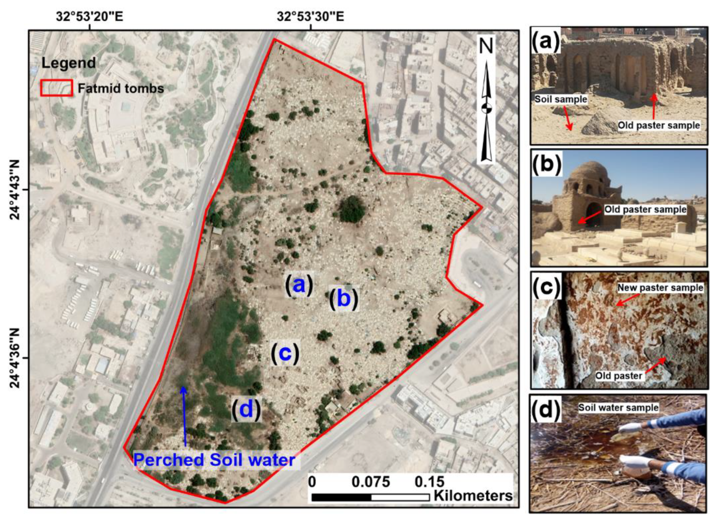
2. Study Area Characteristics with a Description of the Archaeological Fatimid Tombs and Environmental Challenges

Aswan is established in the south of Egypt on the east side of the Nile River, is one of the most marvelous tourist cities [49] due to the existence of the Simbel, Philae, and Isis temples, the Unfinished Obelisk, and some historical graves (Figure 1a). The study area covers a total area of 20.43 km2 (Figure 1b).
Geomorphologically, the study area can be classified into three topographical parts: high terrain, low Aswan plains, and the Nile River (Figure 3). The high elevated terrains are mainly composed of basement rocks (≈170 m above sea level, a.s.l), located in the middle (El-Sheikh Haroon plateau) and western (Gebel Tagug and El-Karor) parts of the area under study. The low Aswan plains, located on the eastern and western periphery of the El-Sheikh Haroon plateau, are the old Nile channels. Different valleys incised these mountains and plains areas. Geologically, Aswan and its districts were built on heterogeneous near-surface sediments varying from the Precambrian to the Quaternary age (Figure 3), including basement rocks (granite), Nubian sandstone (ferruginous sandstone and clays) rocks, and Quaternary sediments (sands, gravels, and clays). The hydrogeological regimes comprise [50]: (a) the Nile River, which is the primary source of fresh water, and (b) the eastern and western Quaternary aquifers. The Quaternary aquifers are mainly composed of gravel, sandstone, and clay intercalation under unconfined conditions that are recharged mainly from Dam Lake and the seepages of water facility pipes. Aswan experiences an arid climate characterized by a hot summer (38 to 42 °C).
The Fatimid cemetery is located in the southern part of the modern town of Aswan (Figure 1a,b). The area of study is located between latitude of 24.0778° N and longitude of 32.8917° E) [52]. As the cemetery is still in use today, it provides us with a unique cultural historical landscape, and the domes are built in the exclusive Fatimid style. The tombs contain domes that remained intact even before the year 1930 AD, which numbered 80.
In the middle of the previous century, many of them have been destroyed, and only 30 scattered models are currently left due to the reconstruction and expansion of Aswan city. The history of this cemetery extends from the second century AH (the eighth century AD) to the seventh century AH (the thirteenth century AD). These domes were built on a system of load-bearing walls, like other Islamic monuments, in monolithic molds. The predominant building material was mud-bricks, except for some parts of these tombs, such as the vaults, necks of domes, and the domes themselves, which were built of bricks. As parts of stone strips appeared in some domes, gypsum coverings also appeared on the inside and outside of some of these tombs, such as tomb No. 12 in the eastern group of the tribal cemetery and tomb No. 31 of the same group, and tomb No. 5 of the western group of the tribal cemetery, where the gypsum decorative parts can be clearly seen [53]. Tombs are generally built from raw bricks, with some exceptions. They are covered in white. They are small in size and a lot of them were ruined.
The tombs also vary in decoration; two types of decorations are very regular. In the stucco techniques, artists used mortars instead of marble, as these materials were cheaper than marble, and lime plasters can be easily molded in every shape and with less effort and cost [54]. Most likely, Aswan’s stucco was imported from outside the area, as the production of this material requires lots of fuel.
Different forms of damage caused by natural and anthropic interventions can be detected both from the outside and the inside in the monumental area under study. From the outside, the dome has four facades: the eastern facade and its current height is 1.30 m. Above it, near the end of the facade, is a window with a pointed arch of the same shape and a wall thickness of 0.55 m. (Figure 2j). The interior is a square with sides 3 m long, and in the middle of the eastern side, there is an entrance with a pointed arch, 1.7 m wide and 0.25 m deep. Height is 2.05 m. In the middle there is a Mihrab with a similar arch. (Figure 2j). In addition, the dome No. 15 of the Fatimid tombs had some damage, such as gypsum falling off the walls and the hand script on the walls from the outside. (Figure 2d). The same problems of falling out, intended destruction, loss of gypsum decorations, and coloring of gypsum with modern paint inside the dome were observed (Figure 2e).

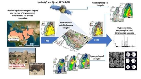
3. Materials and Methods

In this study, a holistic integration of space-borne (including multispectral and topography) and hydrogeology datasets through a GIS environment was conducted as a vigorous method to evaluate the causes of groundwater rise and their consequences on the Fatimid archaeological tombs (Aswan). Furthermore, various physicochemical, mineralogical, and morphological evaluations were established for the structures and the surfaces of historical monuments to anticipate the temporal degradation behavior and develop preventive conservation. Table 1 illustrates the various datasets sources used in this study.

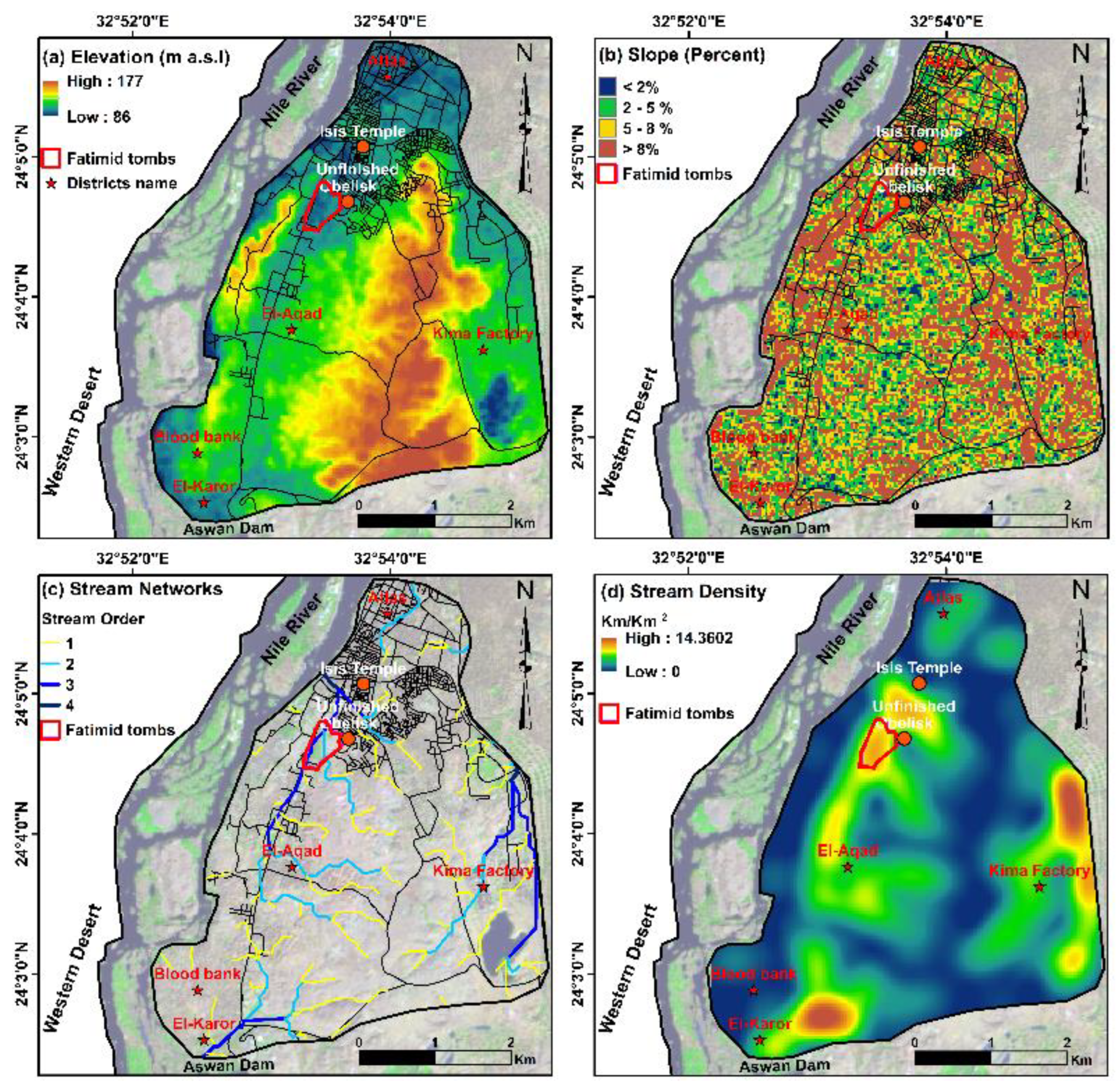
3.1. Geospatial Analysis of Environmental Controlling Indices

Geospatial mapping methods were used to highlight the spatial distribution and contribution of environmental determinants (geomorphological, lithological, and hydrogeological), along with anthropical activities. First, the Aswan GIS database was established for different digital images generated from available and ancillary datasets. All digital images were co-registered to a unified projection (Universal Transverse Mercator (UTM) coordinate system, datum WGS 1984, and zone 39N utilizing the ArcGIS Pro 2.9 package developed by ESRI [55].
Four LULC maps were produced using multispectral satellite scenes for the years 1986, 2010, 2014, and 2021 to identify the patterns of urbanization and their possible impact on the study area. The scenes (path 174, row 43) were obtained from two Landsat 5 and 8 sensors spanning three decades from 1986 to 2021, with a minimum cloud cover and similar season (Table 1). All data were freely downloaded from the U. S. Geological Survey (USGS) database. The five-step procedure [56] implemented in this paper comprises (1) the image pre-processing method, (2) different image enhancement methods, (3) image classification (1986–2021) utilizing maximum likelihood supervised classification, and (4) accuracy assessment using grounds truthing data and Google Earth Pro imagery.
The Shuttle Radar Topography Mission (SRTM) DEM data were employed to obtain the elevation, slope, and stream network layers, as well as to estimate the stream density map using the spatial analysis tool in Arc Hydro tools. The SRTM-DEM dataset (acquired on 27 June 2000) was downloaded from the USGS, with a spatial resolution of 30 m. The spatial distribution of stream networks was obtained using hydrology tools in ArcGIS map as follows: (1) the sinkholes (i.e., depressions) were filled to raise the elevation levels to their neighboring areas, (2) a flow direction map was created from the DEM “filled” image applying the eight-direction algorithm (D-8) according to [57], (3) a threshold value of 100 was defined to approximate flow accumulations, and (4) the “stream order” for each channel was computed using stream distributions and flow direction products.
Also, of interest is hydrogeological investigation, the emphasis is on evaluating the geo-environmental risks related to the fluctuation of soil water levels and salinity contents. Surplus salinity contents over the permissible limits provide a precarious environment for the life of the rocky and muddy archaeological structures exposed to shallow groundwater levels [58,59]. Therefore, the groundwater measurements were collected from a published source (see Table 1). Accordingly, the hydrogeological cartographic distributions for current depth to water, sulfate (SO4−2), chloride (Cl−1), total dissolved salts (TDS), nitrate (NO3), bicarbonate (HCO3), and potential Hydrogen (pH) were created using IDW methods.

3.2. Physicochemical and Mineralogical Investigation

For complete documentation of the case study, weathering compounds, soil, subsoil water, and plaster samples were extracted from the Fatimid cemetery area (Figure 4a–d). All collected samples were labelled and stored in tightly closed plastic bags before testing.

3.2.1. Physicochemical Analysis of Soil

Ten soil samples were collected from the Fatimid cemetery in a zigzag pattern to ensure uniform distribution and to cover a wide range of weathering forms presented in domes. The samples were collected from small borrow trenches (approximately 50 cm depth). By using a sampling spoon, the same amount of soil was extracted from each sampling point. The soil samples were crushed using a pestle and mortar to accelerate the drying process in the oven at a temperature of 100 °C for 24 h. According to ASTM D 422-63, a dry sieve assessment was employed for the soil grain size retained on sieve No. 200. Moreover, hydrometer analysis was carried out on the soil particles passing from sieve No. 200.
The Electrical Conductivity (EC) values of the samples were measured using a systematic process that involved combining the dried samples with distilled water in a ratio of 1:1 (solid: water), shaking this solution periodically for one hour, and finally measuring the EC of the suspension using HI 9033 conductivity meter. The pH test was performed in the same manner, using a GLP21 pH meter.

3.2.2. Soil Water Measurements

The soil water samples were manually collected over the study area site between January and February 2021, at peak hours, three times per week. The subsoil water samples were directly transported to the laboratory and stored at a temperature of 2 °C. All stored samples were mixed before testing, and the remaining quantities of subsoil water were stored at 2 °C.

3.2.3. Heavy Metals Analysis Using Inductively Coupled Plasma Mass Spectrometry (ICP-MS)

Inductively Coupled Plasma Mass Spectrometry (ICP-MS) was utilized to determine the levels of zinc (Zn), cadmium (Cd), manganese (Mn), iron (Fe), copper (Cu), nickel (Ni), and lead (Pb) in soil and subsoil water. Heavy metal levels were measured using an ICP-MS (Nexion 300D, PerkinElmer, Shelton, CT, USA) after treatment and acid digestion. Argon (Ar) at 0.6 L/min was used to provide make-up gas when the laser ablation chamber and ICP torch were used simultaneously. High spatial resolution was accomplished since the ablation spot size was determined to be 5 m, with 136 m between each line.
Efflorescence is normally the result of the evaporation of saline water existing in the porous structure of the stone. Efflorescence is often founded on soluble salts such as sodium chloride (halite: NaCl) or sulphate (thernadite: Na2SO4), magnesium sulphate (epsomite: MgSO4. 7H2O), but they may also be made of less-soluble minerals such as calcite (CaCO3), barium sulphate (BaSO4), and amorphous silica (SiO2. nH2O) [60].

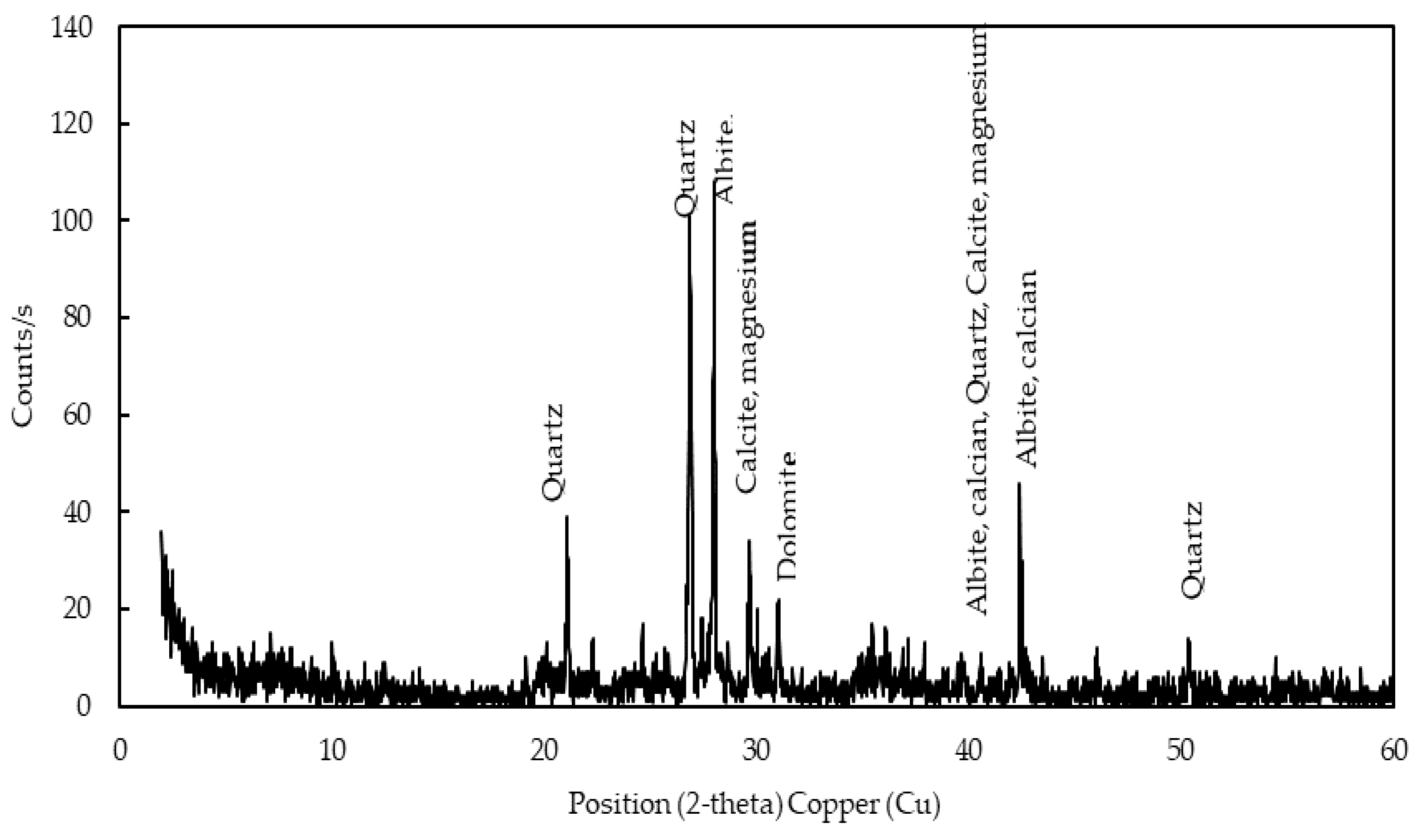
3.2.4. Mineralogical Study Using X-ray Diffraction (XRD)

Three samples were collected from the most deteriorated parts of the new plaster located outside the Fatimid domes, the old plaster from inside the domes, and the soil. All samples were wisely collected from severely damaged and fallen parts.
The mineralogical composition of the soil, new plaster, old plaster, and cemetery wall samples was determined using XRD analysis. The XRD test specimens were air-dried before being pulverized with a mortar and pestle. The XRD analysis was performed using an XRD equipment model X’ Pert PRO with a monochromator and Cu-radiation (λ = 1.542 Å) at 45 kV, 35 mA, and a scanning speed of 0.03 °/s. The reflection peaks were acquired between 2θ = 2° and 60°, as well as the corresponding spacing (d, Å) and relative intensities (I/Io). After that, the diffraction charts and relative intensities were obtained and compared to data from the International Centre for Diffraction Data (ICDD).

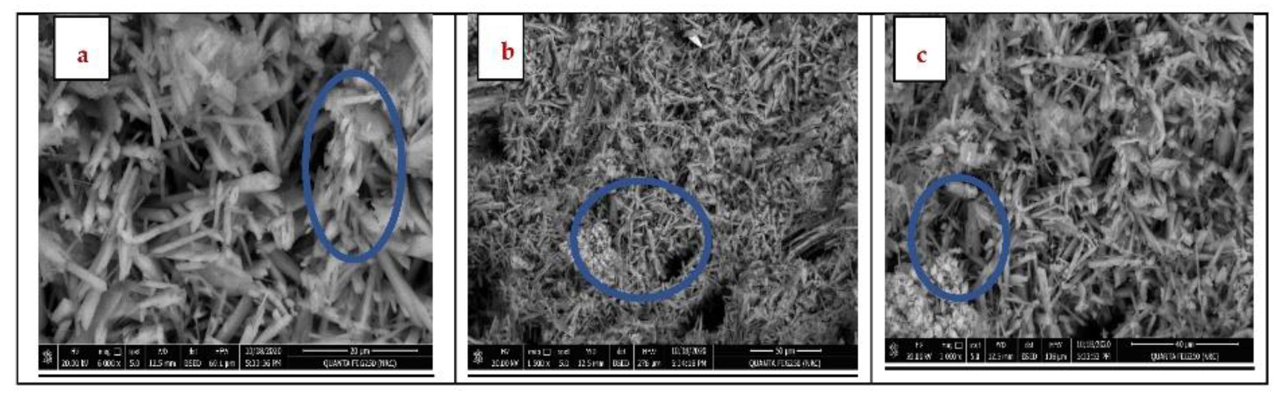
3.2.5. Morphological Study Using a Scanning Electron Microscope (SEM)

The morphology of the soil, new plaster, old plaster, and cemetery wall samples were assessed using a Scanning Electron Microscope (SEM)—JEOL model JSM 636O LA with a high-resolution range from 100 to 0.5 nm at 20 kV. The samples were prepared in an identical manner employed in the XRD test and were coated by a thin layer of gold 5 to 50 nm.

3.2.6. Scanning Electron Microscope Attached with Energy Dispersive X-ray (SEM—EDX)

The SEM (JEOL JSM 6400) coupled with an energy-dispersive X-ray spectrometer (EDS) with an accelerating voltage of 20 kV, coating the samples with a highly conductive thin film of gold, was used to reveal details of the digenetic processes. The SEM/EDX combination is used extensively for all types of material analysis and for documenting and interpreting degradation processes or controlling conservation [61,62].

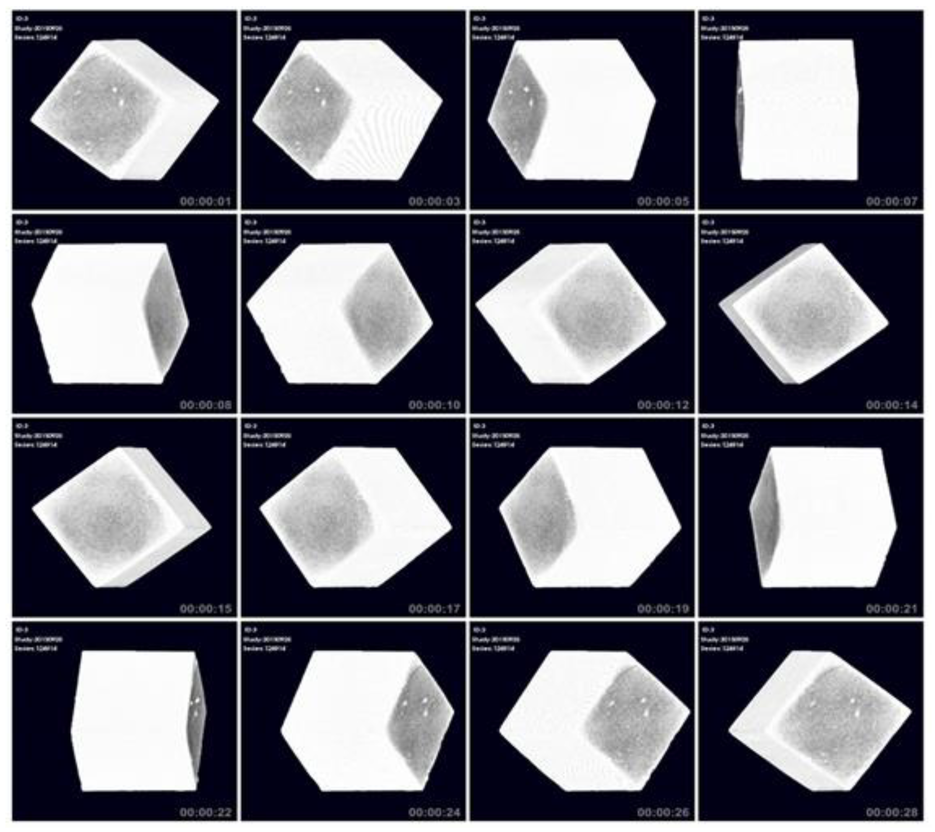
3.2.7. Computed Tomography (CT) Scan Analysis

A Computed Tomography (CT) system employs a motorized X-ray source that revolves around a circular opening. All X-ray imaging is based on the absorption of X-rays as they pass through the different parts of the sample. The information is picked up by the detectors and transmitted to a computer to reconstruct all the angles which are collected during a complete rotation. A micro-CT (Quantum FX, PerkinElmer, and Waltham, MA, USA) was used to scan the samples. The scans were performed under tube voltage 90 kV, a tube current of 160 µA, a field of view of 20 mm, and scan time of 4.5 min. The analysis was carried out at Karolinska Institute, Stockholm, Sweden

4. Results and Discussion

4.1. Evaluating the Contribution of Environmental Factors to the Subsoil Water-Related Risks

Natural and anthropogenic factors may have an impact on the occurrence of environmental hazards, either positively or negatively. This cannot only be achieved from the documentation and studying of the building material characteristics, but it is also crucial to avoid delinquency from studying the locations separately, because surrounding environmental determinants can be important for defining the most influencing factors.
The elevation of the investigated area decreases steadily from 177 m (a.s.l.) in the middle areas to 86 m (a.s.l.) toward the northern and eastern parts (Figure 5a). This variation facilitates the shallow soil water movement toward the low-laying (<2%) Fatimid tombs region (Figure 5b). The flat surfaces proved to be more susceptible to waterlogging and ponding areas over the years [63]. Three natural stream networks mainly originated from the middle–high terrain, with E-W, NE-SW, and SW-NE directions toward their outlets in the northern, eastern, and southwestern regions, respectively (Figure 5c). The stream density ranges from 0 to 14.36 km/km2 (Figure 5d).
The LULC classified maps showed dynamic change among the majority of land cover classes (Figure 6a–d), which may reflect the possible impact of anthropogenic activities during the last three decades. The created LULC maps were deemed to be accurate with overall accuracies of more than 95%. The findings revealed a substantial increase in urban and waterlogging by 4.82 and 0.31 km2, respectively, from 1986 to 2010, whereas the net area of bare land, vegetation, and wetlands decreased by 3.52, 0.77, and 0.85 km2, respectively (Table 2). Between 1986 and 2010 (Figure 6a,b), urban development has mostly been focused in the western areas of Egypt along the Nile River and Fatimid tombs. Furthermore, the urban area rose by 1.75 and 0.69 km2 in the subsequent periods of 2010–2014 and 2014–2021, respectively (Figure 6c,d and Table 2).
Undoubtedly, the urban developments were established over the stream networks in the western parts, which in turn supports the soil water flows along the floors of the streams [64], resulting in perched soil water at the end of main channels in the low flatness Fatimid area (Figure 7a). The stream density is high in the Kima and Fatimid areas, which is inversely proportional to the infiltration rate of soil water. Moreover, swamps and waterlogging were observed in these areas, which affect the foundation of many infrastructures. As a result, the wetlands areas regained a total of 0.48 km2 and 0.15 km2 in the periods of 2010–2014 and 2014–2021, respectively (Table 2). This corresponds to the increase in the wetlands class, particularly in the Fatimid area, during the period 2014–2021.
It is worth noting that the wetlands area corresponds to scanty plants and bare wet soils (see Figure 2a–c and Figure 6), which frequently correlated with shallow water levels in the Fatimid area (Figure 4d). Regarding the shallow groundwater nuisance, the depth to soil water (averaging 5 m) levels showed a northward and southwestern decrease, where the soil water approaches the ground surface (<1 m) in the Kima factory, Atlas district, and Fatimid graves area (Figure 7a). The main explanations for the groundwater rising in the eastern and southwestern parts have been blamed on the infiltration from High Dam Lake and the decline in abstraction rates from Kima Lake. However, these remarks can be ruled out as the reason for environmental challenges in the Fatimid tombs, where the nitrate concentration is more than 50 ppm (Figure 7g), reflecting the effluent of wastewater to groundwater.
Furthermore, the soil water salinity (SO4−2, Cl−1, TDS, and pH) contents clarified an increase toward the western parts with a local high at the Fatimid graves and the area north of Kima (Figure 7b–e). The aggressive TDS, SO4−2, and nitrate values were based on >1000, 600, and 30 ppm [65], the thresholds at which the degree of risk to the archaeological sites would increase dramatically. Therefore, the buried archaeological structures situated below the moderately saline soil water level in the Fatimid graves areas would face aggravated deterioration compared to the freshwater. This saline soil water can easily seep into the plasters, causing cracks in the structures, along with expansion for gypsum paste (Figure 2d–h) and severe deterioration of wall painting (Figure 2i,j). There is no good sewage system, but it is random. Given this, it is not at all surprising that water leaked from the domestic and wastewater pipelines into the soil water levels. This leads to the deterioration of the environment surrounding the antiquities, and the site suffers not only from salt and water weathering but also from human activities [66].
Undoubtedly, the expansion of wetlands (weeds and dense plants) is a serious environmental issue in the Fatimid area, hiding the features of the archaeological domes (Figure 2a). Moreover, these plants were more prone to threats of catching fire (Figure 2c), posing a reoccurring threat to the dome foundations. Many studies have examined the damaging effect of hoes and plants on archaeological sites, as well as the most effective way to remove them [67,68]. According to Jackson et al. [69], a huge stem requires three times more water than typical plants. Consequently, the recurring maintenance of sewage and fresh networks is required to reduce the amount of water to the site, and thus reduce plant growth. Until now religious rites have been held (Figure 2l) in this archaeological site with the use of a lot of water, and due to the lack of awareness of the importance of the place, this has resulted in the destruction of the domes’ decorative gypsum elements. Needless to say, all of these serious scenarios will have a significant impact on the site’s condition, which worried us as it may bring huge challenges to the cultural heritage conservation.

4.2. Manifestations and Effects of Deterioration Factors on Fatimid Archaeological Domes

As previously mentioned, the graves are located within the polluted urban area, showing varying degrees of deterioration. Many common moisture problems can be traced back to the use of poorly durable materials in construction or neglect of maintenance. The line of development of these tombs is quite uncertain. The domes were plastered from outside and inside by covering one other mortar’s layers of different thicknesses and compositions. In the stucco techniques, artists used mortars instead of marble, as these materials were cheaper than marble, and lime plasters can be easily shaped into any shape [70]. This research is focused on selecting some models for domes with mortar and gypsum remains that showed repeated damages; field investigations show a wide range of weathering forms in most domes, especially on decorative gypsum, plasters, and Muqarnas (Figure 2 and Figure 4).
With a few exceptions, tombs are constructed of raw bricks. They are completely white and mostly small in size. A number of these structures have been destroyed. The tombs also vary in decoration; two types of decorations are very common. A horizontal inscription on the surface represents a niche with a pointed arch. The second relates to the outer walls and comprises vertical cavities of different widths that cut the outer face. The style is commonly found in the southern group which contains relatively large mausoleums, which may have been built later than most tombs. The line of development of these tombs is quite uncertain [71]. The domes from outside and inside were plastered by multiple covers of mortar layers of different thicknesses and compositions. Gypsum in mortars frequently contains minor percentages of sand and limestone powder, supporting the concept that gypsum was used as processed: 70–90% gypsum, 8–17% crumpled limestone, and 2–8% sand [72].
Moisture is commonly caused by shallow subsoil water levels that can damage building materials and components. Regarding the inundation and capillary rising of groundwater given by Jones [73], regions underlay by shallow groundwater levels between 0–2 and 2–2.5 m were, respectively, assigned high and very high vulnerability ratings (Figure 7a). The soil water is directly below the floor of the domes in the Fatimid area during dry seasons and rises several inches above the ground during the high-water level (Figure 2b and Figure 8g). Many of them are surmounted by copulas [74]. As a result, the analysis of the subsoil water received special attention. The subsoil water is considered an aggressive deterioration factor, due to the existence of high TDS and Cl−1 contents (Figure 7). However, such problems can be avoided by following recent techniques that are based on a solid understanding of how urban salinity behaves in the archaeological buildings [75]. For example, the structural failure of plaster wall decoration results from chemical reactions with building materials and weathering components (Figure 2i,j and Figure 8). Moreover, the outer walls have suffered severely (Figure 2d,g and Figure 8), and even some domes and Muqarnas have become permanently missing (Figure 2e,h and Figure 8c,d). It turns out that the walls were falling apart not only from exposure to weather, age, neglect, and poor handling, but also from poor material of the foundations. The near-surface soils are dominated by silt and sand contents with an average of 13% and 87%, respectively, which support the soil water-retaining capacity in the Fatimid area (Table 2). In most domes, therefore, a layer of mud-bricks and gypsum was observed on the lower edge of the dome wall that was dissolved by water. Moreover, the swelling of the soil is widespread, which in turn weakens the building.
Table 2. The area and amount of change in LULC classes (km2) observed in the area under study between 1986–2021. The negative sign (−) indicates a decrease in the land cover class.
Classes1986201020142021Difference
1986–2010
Difference
2010–2014
Difference
2014–2021
Bare land13.419.897.576.64−3.52−2.31−0.93
Urban4.168.9910.7311.424.821.750.69
Vegetation0.960.200.340.34−0.770.150.00
Wetlands1.951.101.581.74−0.850.480.15
Waterlogging0.000.320.250.340.31−0.060.09
A high EC value of subsoil water (Table 3) is obtained, which coincides with the high concentrations of nitrates, chloride, sulfate, and TDS (Figure 7). This enforces the damage to bricks by the migration of soluble salt that is dissolved by water wicks through the brick by capillaries. As the water evaporates in the dome’s interior, the salt left behind crystalizes and splits the surface layer off the brick, exposing its interior. This process is called sub-fluorescence.
An important component of domes is that gypsum (CaSO4·2H2O) plaster contains about 20.9% of the mass of chemically compounded water, which is simply lost at high temperatures. This phenomenon is recognized as dehydration, and the dehydration reaction is thermal, in other words, energy is required to break the crystal water [76]. Conversion of the gypsum content to anhydrite is one aspect of the common degradation of stucco and gypsum used in decorative elements, which undoubtedly experience a physical-chemical change due to high temperatures from exposure to fire, causing the plaster to crack and fall from the dome and become pieces. A similar event occurred in the Al-Aqsa Dome [77].
The gypsum layer shows a clear sensitivity to dryness, and we find that at temperatures that are higher than 30 degrees Celsius, and in the presence of a relative humidity of up to 40%, gypsum loses water and turns into anhydrite, and in this case, gypsum becomes a relatively weak mortar on surfaces. Through this study with a scanning electron microscope equipped with an EDX unit, we find that the gypsum mortar used is in a state of deterioration and disintegration, in addition to the presence of a large proportion of navigator crystals, especially in the lower parts of the walls bearing the dome close to the ground. The gypsum and weak building materials in the domes suffer from the effects of the various and harmful environmental conditions surrounding the archaeological area of the domes, especially the impact of the diversity in temperature, which shows its clear effect in the separation, cracks, and general weakness of all the materials that make up the dome layers (Figure 8). Additionally, the components of the soil that have been identified, and the continued presence of groundwater in that soil on which the domes are built, lead to the swelling of its components and then their shrinkage; all these factors combined work to damage the walls and decorations of the archaeological domes. The results of the XRD analysis support the mineral composition of the new and old plaster fragments that were revealed from the thin section investigation, as listed in (Table 4, Table 5 and Table 6).
The results of the XRD analysis of the mineral composition of the new and old plaster fragments taken from the dome under this study are included in (Table 4, Table 5 and Table 6). The XRD pattern of the old plaster is presented in (Figure 9 and Table 4). The major peaks are albite, calcian ((Na, Ca) Al (Si, Al)3 O8) at 2-theta = 28.05°, 29.18°, and 35.79°, quartz (SiO2) at 2-theta = 21.07°, 26.93° and 50.53°, braunite (Ca Mn14 + 3 Si O24) at 2-theta = 21.07°, 26.93°, and 32.83°, and zircon, metamict (Zr SiO4) at 2-theta = 19.95°, 26.93°, 35.79°.
The result of the XRD analysis of the new plaster fragments revealed that calcite is a major mineral, but quartz and gypsum are trace minerals in the old gypsum sample (Figure 10 and Table 5), whereas the major peaks are albite (Na (Si3 Al) O8) at 2-theta = 26.73°, 27.59°, 28.19°, 29.65°, 39.67°, 48.79° and 50.53°, quartz (SiO2) at 2-theta = 26.73° and 50.53°, calcite, magnesium ((Mg0.06 Ca0.94) (CO3)) at 2-theta = 23.91, 29.69°, 36.41°, 39.67°, 43.49°, 47.15°, and 48.79°, haigerachite ((Fe0.84 Al0.16)3 KH14 (PO4)8 ·4 H2O) at 2-theta = 10.09°, 27.59° and 50.53°, and hematite (Fe2O3) at 2-theta = 33.37°.
The result of the XRD analysis of one deteriorated sample of soil revealed that calcite is a major mineral (Figure 11 and Table 6), but gypsums, manganese, and hematite are trace minerals. The major peaks for soil are albite, calcian ((Na, Ca) Al (Si, Al)3 O8) at 2-theta = 28.01°, 40.75° and 42.41°, quartz (SiO2) at 2-theta = 21.07° and 50.41°, calcite, magnesium ((Mg0.06 Ca0.94) (CO3)) at 2-theta = 29.69° and 40.75°, and dolomite (Ca, Mg (CO3)2) at 2-theta = 30.03°.
In addition to the nature of the impact materials, their internal composition, particularly the proportion of gypsum and sand additives in the mortar, is another crucial factor that controls the level of cracking, loss, and damage [78]. Weathered gypsum samples and soil were investigated by SEM pictures, which presented that the physical structure of the sample had seriously collapsed due to the serious effect of crystalline salts, the impact of groundwater rising, and associated salinity issues (Figure 12a–c). Figure 12a–c shows the disintegration due to salt weathering of the internal structures of the plaster and soil samples. Furthermore, the morphology and microstructure of the mineral constituents in the three stucco samples were recorded before and after the application of potassium sulphate. The deterioration was detected on gypsum samples taken from Muqarnas inside the dome.
Several studies on the historical gypsum of some ancient Egyptian tombs in Aswan, Luxor, and Siwa Oasis indicate that gypsum turns into anhydrite, and the approximate percentage of its results ranged between 24% and 97%. [79,80,81]. The disappearance of the gypsum phase and the appearance of the anhydrite and basanite phases were also observed by analyzing the gypsum samples by X-ray diffraction after exposure to fire [82]. The results of our study using X-ray diffraction and scanning electron microscopy of the samples showed the gypsum of the Muqarnas and the plaster layers on the walls of the Fatimid tombs. It is clear that the crystals of the gypsum samples have broken and turned into anhydrite, and the gypsum crystals from the Muqarnas collapsed. The gypsum crystal structure was broken down to reveal anhydrite and quartz, and the samples appeared in the form of a needle and the accumulation of crystallized salts. The percentage of anhydrite was about 22% in some samples, and in most of the samples, it turned out that gypsum became trace minerals in the samples under study. This is due to the damaging factors that these domes are exposed to.
Groundwater is loaded with dissolved salt ions that cause damage to archaeological building materials as the water rises to the top, carrying with it salts of Cl, NO3, SO4, Mg, Ca, K, and Na, and those ions contained in the water are harmful to the building. When analyzing samples of water from the bottom of the cemetery, the sample showed that the pH was 7 at a temperature of 25 °C, and we found the presence of phosphorous, iron, and magnesium elements in high concentrations, which cause many damages and necessitates the need for immediate protective action.
The analysis results of the water sample taken from the bottom of the cemetery showed the presence of the following elements and their concentration as follows: phosphorus (P) 5.386, iron (Fe) 0.123, manganese (Mn) 0.181, copper (Cu) 0.075, zinc (Zn) 0.056, cadmium (Cd) 0.001, lead (Pb) 0.078, nickel (Ni) 0.026. (see Figure 13, Figure 14 and Figure 15 and Table 7).
In addition to the decomposition observed in gypsum crystals and the loss of binding materials, we detected an increase in pore size, cracks, and destruction in the internal structure as a result of the internal stresses between the mineral crystals, due to the re-crystallization of salt within the pores. The results revealed that calcium (Ca), silicon (Si), carbon (C), and oxygen (O) make up the majority of their composition. (see Figure 13 and Figure 14 and Table 8).
The outcomes of CT scanning support the case for this technology in the identification (Figure 15), documentation, and conservation of our built heritage. The following findings from our investigation are particularly noteworthy: the plaster and wall samples had some porosity content, corresponding to a loss of a part of composite minerals. The domes need to be quickly conserved and consolidated because they are in bad condition. According to the results obtained from CT images, the majority of CT images show the detachment of the paint layer from the ground layer due to temperature and relative humidity variations, mechanical stresses, and the different physio-chemical properties of the sample due to the difference in sample minerals. Figure 15 shows the CT scan method assisted in the investigation surface image detail. Such cases appear in a large group of buildings in the Arabian Peninsula, such as the buildings of the residential area in Miqat Al-Juhfa in Saudi Arabia [6,83].
Typically, extreme humidity levels in the environment have a significant role in the deterioration and loss of plaster [84]. The Aswan region has a dry and low-humidity climate, which contributed to the steadfastness and longevity of such domes. Over time, all these activities may cause slow and significant changes, including the pattern of stresses in the structural elements due to the effects of moisture, salt weathering, plaster cracking, salt stains, the loss of mortar, the absence of decorative gypsum elements, the fall of the ceiling, and subsequently, the complete collapse of the building (Figure 8).
Through the previous study, it became obvious that prior to any restoration attempts, it is crucial to analyze the different components and evaluate the condition of their deterioration and damage. Most of the domes need preservation and restoration, whereas the southern cemetery on the whole is a site of neglect. It is obvious that the restoration of more than fifty domes and several hundred tombs will be exceptionally difficult, require significant effort, and cost a substantial amount of money. According to our study, the majority of the domes exhibit similar indications of deterioration, including vertical cracks and structural weakness. Nanomaterials can be added to the damaged region to strengthen and fix the gypsum remains, and comprehensive restoration work can be carried out on the entire archaeological site. The damaging influences do not only distort the plaster but also might cause the permanent loss of the domes with carelessness in treatment and restoration [85]. Some of the domes were covered with one layer of clay and the others with plaster. On dome No. 114, which is similar to No. 113, almost identical restoration work was carried out. (Figure 8e,f) These works were carried out in cooperation with foreign missions in previous years. The treated domes received a new layer of clay, and one of the lime plasters was an external plaster on the domes in some parts still in place.
To that end, this study provides the decision-makers with current and up-to-date information on the deterioration of archaeological sites in Aswan caused by natural and human forces in a remote sensing and GIS framework. Our recommendations are not limited to officials in Egypt; officials in Saudi Arabia are also included, especially when dealing with cases of similar sites. CT scanning as NDT, the result obtained from CT images, and different analyses by XRD and EDX results showed the major composition of the dome.

5. Conclusions

Aswan city definitely symbolizes a magnificent site of tourism in the land of the Nile Valley due to well-preserved ancient structures, including temples and archaeological sites. The Fatimid cemetery is among these ruins. Despite the availability of funded research, archaeologists and structural engineers still view the conservation and strengthening of historic buildings as their greatest challenges, particularly for earthen mud-brick dome structures.
The archaeological domes are susceptible to falling due to the attack of weathering processes and several deterioration factors. Deterioration mechanisms are complicated because they are influenced by a variety of factors (physical, chemical, and biological). These factors, while continuing, cause the absolute loss of the gypsum decoration. To assess the deterioration affecting the gypsum in domes and determine their rates, various samples were collected from deteriorated gypsum, Muqarnas, and plaster on dome walls, as well as soil and soil water, to investigate the use of various techniques.
The research goals have been achieved through the following steps: (A) evaluation of the building materials, including the integrated morphological, mineralogical and physicochemical testing; (B) estimations of relevant factors affecting these building materials; (C) integrated vulnerability assessments of the Fatimid cemetery geo-environmental conditions; (D) determination of weathering forms and changes in domes, especially on decorative plaster, gypsum plaster layer, and stucco. The multitemporal changes in LULC displayed that the haphazard developments in Aswan city—ignoring the environmental characteristics in urban expansion—increased the wetlands associated with scanty plants that altered the natural conditions of the Fatimid tombs. The results obtained with the screening techniques (SEM-EDX and XRD) concluded that the plaster in the dome consists of layers on the mud-bricks. The results of the study also indicate the influence of damage factors on the domes, and they appear clearly in the fall and collapse of many parts of the domes. One of the most dangerous decomposition factors is wet soil. This effect appeared in several forms of weakness, cracks shrinkage, wrinkling and falling decorations from the layer clearly observed. Through this study, we find that the gypsum plaster is completely lost and damaged, and this justifies the fact that the XRD data never detected gypsum, or only in the trace.
Subsoil water and soluble salts are common deterioration factors in the case study. The subsoil water level is very high and can be observed inside the soil and on floors and walls, while some samples contain sodium chloride, which has an adverse effect on gypsum. The present study indicates the dependence of the mechanical properties on the physicochemical and mineralogical properties of the studied construction materials. Modeling the properties indicates a correlation between the different parameters. Consequently, a well-focused strengthening and retrofitting program is necessary.

Author Contributions

Conceptualization, M.M.E.K., M.S.A. and A.S.; methodology, M.M.E.K., S.M.K., M.S.A., Y.M.Y. and A.S.; software, M.M.E.K., S.M.K. and Y.M.Y.; validation, M.M.E.K. and A.S., S.M.K., M.S.A. and Y.M.Y.; formal analysis, M.S.A. and S.M.K.; investigation, M.M.E.K.; resources, A.S.; data curation, M.M.E.K., A.S. and Y.M.Y.; writing—original draft preparation, M.M.E.K., M.S.A., S.M.K., Y.M.Y. and A.S.; writing—review and editing, M.M.E.K., M.S.A., S.M.K. and Y.M.Y.; visualization, M.M.E.K.; supervision, M.M.E.K., M.S.A. and S.M.K.; project administration, M.S.A. and Y.M.Y.; funding acquisition, M.M.E.K. and A.S. All authors have read and agreed to the published version of the manuscript.

Funding

This research received no external funding.

Data Availability Statement

Not applicable.

Acknowledgments

The authors are grateful to the editor and anonymous reviewers for their thoughtful and constructive comments on our paper. Finally, we would like to thank USGS Glovis for providing the Landsat and SRTM datasets.

Conflicts of Interest

The authors have no conflict of interest.

References

  1. Friesem, D.E.; Karkanas, P.; Tsartsidou, G.; Shahack-Gross, R. Sedimentary processes involved in mudbricks degradation in temperate environment: An ethnoarchaeological case study from northern Greece. J. Archaeol. Sci. 2014, 41, 556–567. [Google Scholar] [CrossRef]
  2. Attalla, R.; Falana, J.N.; Delany, A. The technology of mud-bricks from the sacred architecture in ancient Egypt to thegreenhouse revolution case study of Luxor city, Egypt. Int. J. Adv. Sci. Technol. 2020, 29, 1264–1277. [Google Scholar]
  3. Bay, M.A.; Alnaim, M.M.; Albaqawy, G.A.; Noaime, E. The Heritage Jewel of Saudi Arabia: A Descriptive Analysis of the Heritage Management and Development Activities in the At-Turaif District in Ad-Dir’iyah, a World Heritage Site (WHS). Sustainability 2022, 14, 10718. [Google Scholar] [CrossRef]
  4. Rodríguez-Navarro, C. Binders in historical buildings: Traditional lime in conservation. Semin. SEM 2012, 9, 91–112. Available online: http://www.ehu.es/sem/revista/seminarios_m.htm#Vol9 (accessed on 24 April 2020).
  5. Alonso-Olazabal, A.; Ortega, L.A.; Zuluaga, M.C.; Ponce-Antón, G.; Echevarría, J.J.; Alonso-Fernández, C. Compositional Characterization and Chronology of Roman Mortars from the Archaeological Site of Arroyo De La Dehesa De Velasco (Burgo De Osma- Ciudad De Osma, Soria, Spain). Minerals 2020, 10, 393. [Google Scholar] [CrossRef]
  6. Alsubaie, M. The Miqat of al-Juhfa: A Historical and Archaeological Study. Ph.D. Dissertation, University of Victoria, Victoria, BC, Canada, 2018; p. 167. [Google Scholar]
  7. Al-Rashid, S. Al-Rabadha: A Portrait of Early Islamic Civilization in Saudi Arabia, 1st ed.; King Saud University: Riyadh, Saudi Arabia, 1986; p. 48. ISBN 13: 9780582783904. [Google Scholar]
  8. Alsubaie, Mohammad, Mecca and Medina in the 15th Century Based on the Manuscript of Korat al-’Ain fi Awsaf al-Haramain al-Sharifain: An archaeological study. Macca, the Center of Mecca History. 2018.
  9. Northedge, A. Creswell, Herzfeld, and Samarra. Muqarnas 1991, 8, 77–79. [Google Scholar] [CrossRef]
  10. Hassaan, G.A. Mechanical Engineering in Ancient Egypt, Part 52: Mud-Bricks Industry. Int. J. Adv. Res. Manag. Archit. Technol. Eng. 2017, 3, 11–16. [Google Scholar]
  11. Rossi, C. Building materials and techniques, Pharaonic Egypt. In The Encyclopedia of the Ancient History; John Wiley and Sons: Hoboken, NJ, USA, 2012. [Google Scholar]
  12. Moguin, M. Ancient Solutions for Future Sustainability: Building with Adobe, Rammed Earth and Mud. In Proceedings of the Sustainable Construction: Proceedings of the First International Conference of CIB TG, Tampa, FL, USA, 6–9 November 1994; pp. 543–552. [Google Scholar]
  13. Capaldi, X. Ancient Egyptian mud-brick construction: Materials, technology and applications for modern man. Egypt Unit Res. Pap. 2011. [Google Scholar]
  14. El-Gohary, M. The contrivance of new mud bricks for restoring and preserving the Edfa ancient granary-Sohag, Egypt. Int. J. Conserv. Sci. 2012, 3, 67–78. [Google Scholar]
  15. Bloom, J. Arts of the City Victorious: Islamic Art and Architecture in Fatimid North Africa and Egypt; Yale University Press: New Haven, CT, USA, 2007. [Google Scholar]
  16. Grabar, O. The Islamic Dome, Some Considerations. J. Soc. Archit. Hist. 1963, 22, 191–198. [Google Scholar] [CrossRef]
  17. Sakkal, M. Geometry of Muqarnas in Islamic Architecture. Master’s Thesis, University of Washington, Seattle, WA, USA, 1982; p. 10. [Google Scholar]
  18. Bloom, J.M. The Introduction of the Muqarnas into Egypt. Muqarnas 1988, 5, 21–28. [Google Scholar] [CrossRef]
  19. Curl, J.S. A Dictionary of Architecture and Landscape Architecture, 2nd ed.; Oxford University Press: Oxford, UK, 2006. [Google Scholar]
  20. Bityukova, L.; Limberg, M. Complex study of composition of building stones of the historical objects in Tallinn (Estonia) and assessment of stone deterioration on the base of geochemical data. Geophys. Res. Abstr. 2005, 7, 1–4. [Google Scholar]
  21. Moussa, A.M.A.; Kantiranis, N.; Voudouris, K.S.; Stratis, J.A.; Ali, M.F.; Christaras, V. The impact of soluble salts on the deterioration of pharaonic and coptic wall paintings at al qurna, Egypt: Mineralogy and chemistry. Archaeometry 2009, 51, 292–308. [Google Scholar] [CrossRef]
  22. Hatır, M.E. Determining the weathering classification of stone cultural heritage via the analytic hierarchy process and fuzzy inference system. J. Cult. Heritage 2020, 44, 120–134. [Google Scholar] [CrossRef]
  23. Baggio, P.; Bonacina, C.; Stevan, A.G.; Fassina, V. Analysis of Moisture Migration in the Walls of the S. Maria dei Miracoli Church in Venice. In Conservation of Stone and Other Materials; Thiel, M.-J., Ed.; RILEM/UNESCO: Paris, France, 1993; Volume 1, pp. 170–177. [Google Scholar]
  24. Ireland, R. Conserving Decorative Plaster. In The Building Conservation Directory; 2005; pp. 1–11. Available online: https://www.buildingconservation.com/articles/decorplast/decorative_plaster.htm (accessed on 31 March 2022).
  25. Allocca, V.; Marzano, E.; Tramontano, M.; Celico, F. Environmental impact of cattle grazing on a karst aquifer in the southern Apennines (Italy): Quantification through the grey water footprint. Ecol. Indic. 2018, 93, 830–837. [Google Scholar] [CrossRef]
  26. Zaghloul, A.; Saber, M.; Gadow, S.; Awad, F. Biological indicators for pollution detection in terrestrial and aquatic ecosystems. Bull. Natl. Res. Cent. 2020, 44, 127. [Google Scholar] [CrossRef]
  27. Toll, D.G.; Abedin, Z.; Buma, J.; Cui, Y.; Osman, A.S.; Phoon, K.K. The impact of changes in the water table and soil moisture on structural stability of buildings and foundation systems. Syst. Rev. 2012. Technical Report. Collaboration for Environmental Evidence. Available online: https://dro.dur.ac.uk/18298/ (accessed on 31 March 2022).
  28. El-Behaedi, R.; Ghoneim, E. Flood risk assessment of the Abu Simbel temple complex (Egypt) based on high-resolution spaceborne stereo imagery. J. Archaeol. Sci. Rep. 2018, 20, 458–467. [Google Scholar] [CrossRef]
  29. Abdulaziz, A.M. Subsurface Characterization for Groundwater Management nearby the Unfinished Obelisk Archeological Site, Aswan Governorate, Egypt. Open J. Geol. 2019, 09, 839–860. [Google Scholar] [CrossRef] [Green Version]
  30. Selim, S.A.; Hamdan, A.M.; Rady, A.A. Groundwater Rising as Environmental Problem, Causes and Solutions: Case Study from Aswan City, Upper Egypt. Open J. Geol. 2014, 4, 324–341. [Google Scholar] [CrossRef] [Green Version]
  31. Abd-Elaty, I.; Negm, A.; Hamdan, A.M.; Nour-Eldeen, A.S.; Zeleňáková, M.; Hossen, H. Assessing the Hazards of Groundwater Logging in Tourism Aswan City, Egypt. Water 2022, 14, 1233. [Google Scholar] [CrossRef]
  32. Abu-Rizaiza, O. Modification of the standards of wastewater reuse in Saudi arabia. Water Res. 1999, 33, 2601–2608. [Google Scholar] [CrossRef]
  33. Meijerink, A.M.J.; Bannert, D.; Batelaan, O.; Lubczynski, M.W.; Pointet, T. Remote Sensing Application to Groundwater; United Nations Educational, Scientific and Cultural Organization: Paris, France, 2007; p. 309. [Google Scholar]
  34. Youssef, Y.; Saada, S.A.; Gemail, K.S.; Sugita, M.; Teama, M.A.; AlBarqawy, M.; El Shinawi, A.; Khedr, F. Multi-temporal analysis of Coastal Urbanization and Land Cover Changes in Suez City, Egypt Using Remote Sensing and GIS. Front. Sci. Res. Technol. 2022, 4, 2682–2962. [Google Scholar] [CrossRef]
  35. Manik, S.M.N.; Pengilley, G.; Dean, G.; Field, B.; Shabala, S.; Zhou, M. Soil and Crop Management Practices to Minimize the Impact of Waterlogging on Crop Productivity. Front. Plant Sci. 2019, 10, 140. [Google Scholar] [CrossRef] [PubMed] [Green Version]
  36. El Bastawesy, M.; Cherif, O.H.; Sultan, M. The geomorphological evidences of subsidence in the Nile Delta: Analysis of high resolution topographic DEM and multi-temporal satellite images. J. Afr. Earth Sci. 2017, 136, 252–261. [Google Scholar] [CrossRef]
  37. Youssef, Y.M.; Gemail, K.S.; Sugita, M.; AlBarqawy, M.; Teama, M.A.; Koch, M.; Saada, S.A. Natural and Anthropogenic Coastal Environmental Hazards: An Integrated Remote Sensing, GIS, and Geophysical-based Approach. Surv. Geophys. 2021, 42, 1109–1141. [Google Scholar] [CrossRef]
  38. Holden, J.; West, L.J.; Howard, A.J.; Maxfield, E.; Panter, I.; Oxley, J. Hydrological controls of in situ preservation of waterlogged archaeological deposits. Earth-Science Rev. 2006, 78, 59–83. [Google Scholar] [CrossRef]
  39. de Beer, J.; Seither, A. Groundwater and cultural heritage. Quat. Int. 2015, 368, 1–4. [Google Scholar] [CrossRef]
  40. Baer, N.S.; Snethlage, R. Moisture Cycles and Sandstone Degradation. In Saving Our Architectural Heritage: The Conservation of Historic Stone Structures; Baer, N.S., Snethlage, R., Eds.; John Wiley and Sons Ltd.: Hoboken, NJ, USA, 1997; pp. 7–24. [Google Scholar]
  41. Graue, B.; Siegesmund, S.; Oyhantçabal, P.; Naumann, R.; Licha, T.; Simon, K. The effect of air pollution on stone decay: The decay of the Drachenfels trachyte in industrial, urban, and rural environments—A case study of the Cologne, Altenberg and Xanten cathedrals. Environ. Earth Sci. 2013, 69, 1095–1124. [Google Scholar] [CrossRef] [Green Version]
  42. Sabbioni, C. Mechanism of air pollution damage to stone. In The Effects of Air Pollution on the Built Environment; World Scientific: Singapore, 2003; pp. 63–106. [Google Scholar] [CrossRef]
  43. Khalil, M.M.E.; Shenoud, R.; Sallam, A. Weathering of Monumental Marble in Egypt: Contribution to Heritage Studies. Des. Eng. 2021, 8, 4483–4506. [Google Scholar]
  44. Youssef, A.M.; Maerz, N.H. Overview of some geological hazards in the Saudi Arabia. Environ. Earth Sci. 2013, 70, 3115–3130. [Google Scholar] [CrossRef]
  45. Singh, A. Review Article Digital change detection techniques using remotely-sensed data. Int. J. Remote Sens. 1989, 10, 989–1003. [Google Scholar] [CrossRef] [Green Version]
  46. Sissakian, V.K.; Ahad, A.D.A.; Hamid, A.T. Geological Hazards in Iraq. Classif. Geogr. Distrib. 2011, 7, 1–28. [Google Scholar]
  47. Mather, P.M.; Koch, M. Preprocessing of Remotely-Sensed Data. In Computer Processing of Remotely-Sensed Images: An Introduction, 4th ed.; John Wiley and Sons: Chichester, UK, 2011; pp. 87–124. [Google Scholar]
  48. Björnesjö, S. The History of Aswan and its Cemetery in the Middle Ages. In The First Cataract of the Nile. One Region—Diverse Perspectives, SDAIK 36, Berlin, Boston; Raue, D., Seidlmayer, S., Speiser, P., Eds.; 2013; pp. 9–13. [Google Scholar]
  49. Elnagar, A.K.; Derbali, A. The Importance ofTourism Contributions in Egyptian Economy. Int. J. Hosp. Tour. Stud. 2020, 1, 45–52. [Google Scholar]
  50. Selim, S. Geological and Hydrogeological Studies of the Quaternary Aquifer in Aswan Town Area, Egypt. Egypt. J. Geol. 1995, 39, 631–645. [Google Scholar]
  51. Egyptian Geological Survey. Geological Map of The Western Desert, Scale 1:100,000 Sheet; Egyptian Geological Survey: Cairo, Egypt, 1985. [Google Scholar]
  52. Kelany, A.; Svenja, C.D.; Lena, S.K. Epigraphy through five millennia, Epipalaeolithic rock art from the east bank near Aswan Types, landscape, and meaning. In Deutsches Archäologisches Institutabteilung Kairo; Harrassowitz Verlag: Wiesbaden, Germany, 2020; Volume 43. [Google Scholar]
  53. Antiquities, E.M.O. Fatimid cemeteries. Egyptian Ministry of Antiquities. 2021. Available online: http://www.antiquities.gov.eg/ (accessed on 1 October 2022).
  54. Megna, B.; Rizzo, G.; Ercoli, L. Characterization of serpottas’ stuccos by means of simultaneous thermal analysis: Preliminary results. Int. J. Conserv. Sci. 2015, 6, 45–50. [Google Scholar]
  55. ESRI. Arc GIS Pro (Version 2.9). Esri Inc. 2021. Available online: https://www.esri.com/en-us/arcgis/products/arcgis-pro/overview (accessed on 13 January 2022).
  56. Abu Salem, H.S.; Abu Khatita, A.; Abdeen, M.M.; Mohamed, E.A.; El Kammar, A.M. Geo-environmental evaluation of Wadi El Raiyan Lakes, Egypt, using remote sensing and trace element techniques. Arab. J. Geosci. 2017, 10, 1–24. [Google Scholar] [CrossRef]
  57. O’Callaghan, J.F.; Mark, D.M. The extraction of drainage networks from digital elevation data. Comput. Vis. Graph. Image Process. 1984, 28, 323–344. [Google Scholar] [CrossRef]
  58. James, A.N.; Edworthy, K.J. The effects of water interactions on engineering structures. Hydrol. Sci. J. 1985, 30, 395–406. [Google Scholar] [CrossRef] [Green Version]
  59. World Health Organization (WHO). Guidelines for Drinking Water Quality, 3rd ed.; World Health Organization: Geneva, Switzerland, 2004; Volume 1.
  60. ICOMOS International Scientific Committee for Stone (ISCS). Illustrated Glossary on Stone Deterioration Patterns, Comité scientifique international “Pierre” de l’ICOMOS. MONUMENTS AND SITES, 49–51, rue de la fédération 75015 Paris, France. p. 48. Monuments & Sites; 2019; Volume XV, ISBN 978-2-918086-00-0. Available online: https://openarchive.icomos.org/id/eprint/2097 (accessed on 20 March 2021).
  61. Moropoulou, A.; Zendri, E.; Ortiz, P.; Delegou, E.; Ntoutsi, I.; Balliana, E.; Becerra, J.; Ortiz, R. Scanning Microscopy Techniques as an Assessment Tool of Materials and Interventions for the Protection of Built Cultural Heritage. Scanning 2019, 2019, 5376214. [Google Scholar] [CrossRef] [Green Version]
  62. Schreiner, M.; Melcher, M.; Uhlir, K. Scanning electron microscopy and energy dispersive analysis: Applications in the field of cultural heritage. Anal. Bioanal. Chem. 2007, 387, 737–747. [Google Scholar] [CrossRef] [PubMed]
  63. Fernández, D.S.; Lutz, M.A. Urban flood hazard zoning in Tucumán Province, Argentina, using GIS and multicriteria decision analysis. Eng. Geol. 2010, 111, 90–98. [Google Scholar] [CrossRef]
  64. Omran, E.S.E. Evolving waterlogged identification system to assess spatiotemporal impact of the new Suez Canal corridor, Egypt. J. Coast Conserv. 2017, 21, 849–886. [Google Scholar] [CrossRef]
  65. USACE (U.S. Army Corps of Engineers). Standard Practice for Concrete for Civil Works Structures; Engineer Manual, 1110-2-2000; USACE: Washington, DC, USA, 1994.
  66. Aretouyap, Z.; Abdelfattah, M.; Gaber, A. Urban sprawl analysis and shoreline extraction in Douala-Cameroon city using optical and radar sensors. Geocarto Int. 2022, 1–13. [Google Scholar] [CrossRef]
  67. Emily, K.S.; Edward, R.; Ronald, D.; Lacewell, A.; McCorkle, A.; Chenghai, Y.; John, G. Biological Control of Giant Reed (Arundo donax): Economic Aspects. In Proceedings of the Southern Agricultural Economics Association Annual Meeting, Atlanta, GA, USA, 3 February 2009; Volume 34, pp. 377–394. [Google Scholar]
  68. Oakins, A. An assessment and management protocol for Arundo donax in the Salinas Valley Watershed. Capstone Project. Presented to Faculty of Earth Systems Science and Policy. In The Center for Science, Technology, and Information Resources; California State University: Monterey Bay-Seaside, CA, USA, 2001. [Google Scholar]
  69. Jackson, N.E.; Katagi, W.; Loper, C. Southern California Integrated Watershed Program Arundo Removal Protocol. Santa Ana Watershed Project Authority. 2002. Available online: http://www.sawpa.org.Arundo.protocol.htm (accessed on 20 March 2021).
  70. Viitanen, H. Moisture and Bio-Deterioration Risk of Building Materials and Structures. In Mass Transfer—Advanced Aspects; 2011; Chapter 25; pp. 580–589. [Google Scholar] [CrossRef] [Green Version]
  71. Speiser. Umayyad, Tulunid, and Fatimid Tombs at Aswan. The South Necropolis of the Fatim. In Annales islamologiques; 2014; pp. 211–221, Electronic ISSN 2429-2850. [CrossRef]
  72. Snell, L.M.; Snell, B.G. The early roots of cement. Concr. Int. 2000, 22, 83–85. [Google Scholar]
  73. Jones, D.K.C. Ground conditions and hazards: Suez City development, Egypt. Geol. Soc. London, Eng. Geol. Spéc. Publ. 2001, 18, 159–169. [Google Scholar] [CrossRef]
  74. Björnesjö, S.; Speiser, P. The South Necropolis of the Fatimid Cemetery of Aswan. Ann. Islam. 2014, 48, 117–134. [Google Scholar] [CrossRef]
  75. U.S.E.P.A. Moisture Control Guidance for Building Design, Construction and Maintenance; Moisture Control in Buildings; Environmental Protection Agency: Washington, DC, USA, 2013; Chapter 1; pp. 1–25. Available online: https://chrome-extension://efaidnbmnnnibpcajpcglclefindmkaj/https://www.epa.gov/sites/default/files/2014-08/documents/moisture-control.pdf (accessed on 24 January 2022).
  76. Ang, C.N.; Wang, Y.C. Effect of moisture transfer on specific heat of gypsum plasterboard at high temperatures. Constr. Build. Mater. 2009, 23, 677. [Google Scholar] [CrossRef]
  77. Lazarini, L.; Schwartzbaum, P.M. The Technical Examination and Restoration of the Paintings of the dome of the Al Aqsa Mosque, Jerusalem. Stud. Conserv. 1985, 30, 129. [Google Scholar]
  78. Wüst, R.A.; Schlüchter, C. The Origin of Soluble Salts in Rocks of the Thebes Mountains, Egypt: The Damage Potential to Ancient Egyptian Wall Art. J. Archaeol. Sci. 2000, 27, 1161–1172. [Google Scholar] [CrossRef]
  79. Kamel, A.M.A.; Marie, H.A.H.; Ali, M.F.; Mahmoud, H.A. Chemical and Physical Characterization of the Stucco Mihrab of the Mausoleum of Muhammad Al-Hasawati, Fatimid period, Cairo, Egypt. Period. Mineral. 2014, 83, 316. [Google Scholar]
  80. Brania, A.A. A Comparative Study of Treatment and Conservation of Rock-Cut Tombs of Nobles of Elephantine (Qubbet El-Hawa) in Aswan, Applied on One of the Selected Tombs. Ph.D. Thesis, Cairo University, Cairo, Egypt, 2001; p. 84. [Google Scholar]
  81. Ballirano, P.; Melis, E. Thermal behaviour and kinetics of dehydration in air of bassanite, calcium sulphate hemihydrate (CaSO4.0.5H2O), from X-ray powder diffraction. Eur. J. Mineral. 2009, 21, 985–993. [Google Scholar] [CrossRef]
  82. Kamel, A.M.A.; Marie, H.A.H.; Ali, M.F.; Mahmoud, H.A. Evaluation of sulphate activators as consolidants for the transformed gypsum in historic stucco. Int. J. Conserv. Sci. 2015, 6, 299. [Google Scholar]
  83. Hughes, S.W. CT Scanning in Archaeology. In Computed Tomography—Special Applications; Intech: London, UK, 2011; pp. 60–69. [Google Scholar] [CrossRef] [Green Version]
  84. Zehnder, K. Long-term monitoring of wall paintings affected by soluble salts. Environ. Earth Sci. 2007, 52, 353–367. [Google Scholar] [CrossRef]
  85. Khalil, M.M.; Mekawey, A.A.; Alatawi, F.A. Microbial Deterioration of the Archaeological Nujoumi Dome (Egypt-Aswan): Identification and Suggested Control Treatments by Natural Products. J. Pure Appl. Microbiol. 2022, 16, 990–1003. [Google Scholar] [CrossRef]
Figure 1. The location of the area under study. (a) Satellite image of Egypt showing the location of Aswan governorate and study area (red polygon) in the south of Egypt, and (b) Aswan city (Landsat 8 (RGB 753)) with the main cities and infrastructures, as well the location of Fatimid tombs shown by a red polygon.
Buildings 12 02175 g001
Figure 2. Field observation showing some photos of the degradation in the Fatimid site caused by soil water conditions and haphazard human activities during fieldwork: (a) soil sampling from the ground and affected structure; (b) collecting samples from the perched soil water; (c) cracks on the structure and falling off some parts of the gypsum plasters at the entrance of the dome; (df) the layers of mortar and Muqarnas have permanently fallen off from the inside and outside walls of the tomb, with the loss of the decorative strip above the entrance; (g) a large number of scanty plants with shallow soil water levels near the graves; (h,i) the outbreak of fire accidents in the sparse vegetation areas more than once, which is always a threat to the graves; and (jl) the illegal burial and religious rites in the Fatimid archaeological area.
Buildings 12 02175 g002
Figure 3. Geological map of Aswan city (modified after [51]).
Buildings 12 02175 g003
Figure 4. Location map of the Fatimid cemetery area showing the places of some collected samples (denoted on the image with a blue label), describing: (a,b) soil and old plaster samples from the ground and affected structure, (c) collecting samples from the old and new plasters, and (d) sampling from the perched soil water.
Buildings 12 02175 g004
Figure 5. The geomorphological maps, with the location of the Fatimid tombs area (purple red polygon) in the northern part: (a) elevation, (b) slope angle, (c) main stream channels with order value, and (d) stream density of the study area.
Buildings 12 02175 g005
Figure 6. Land use/land cover (LULC) changes in Aswan city during the period 1986–2021: (a) LULC map1986, (b) LULC map 2010, (c) LULC map 2014, and (d) LULC map 2021.
Buildings 12 02175 g006
Figure 7. Groundwater distribution maps showing: (a) depth to water level below ground surface in meters, (b) chloride content, (c) sulfate content, (d) total dissolved salts (TDS) content, and (e) hydrogen ions concentrations (pH), (f) bicarbonate (HCO3) concentration, and (g) nitrate (NO3) concentration.
Buildings 12 02175 g007
Figure 8. Showing some photos of the shape and deterioration in the Fatimid dome: (a) shows the presence of eight opposite sides of the dome from the outside, and shows what is known as the horns; (b) we find that the domes are distinguished by the presence of eight opposite sides of the dome from the outside, and it was constructed in several different shapes, including the inverted pyramidal triangle, the flat triangular slab, and the spherical triangle; (c) the domes are either on circular or square projections, and in the case of the square projection, it is necessary to convert it into a circle, erecting spherical triangles in the corners, or bends are made in the corners in the transition area with Muqarnas; also, cracks can be seen on the structure and some parts are falling off; (d) the layers of mortar and Muqarnas have fallen off from the inside and outside walls, with the loss of the decorative strip above the entrance; (e) shows one of the domes that was completely restored according to a project several years ago, demonstrating its architectural design and that it was a dome on a square site; (f) explains that only some parts of some of the domes in the cemetery were restored several years ago, and a full layer of mortar was laid; (g) shows the continuity of ground water and plants that are densely located behind the domes; (h) the leakage of waste water appears from houses located behind these domes as a result of the urban population encroachment and the buildings adjacent to the archaeological cemeteries area.
Buildings 12 02175 g008
Figure 9. XRD analysis pattern of the old plaster for one of the deteriorated Fatimid tombs.
Buildings 12 02175 g009
Figure 10. XRD analysis pattern of the new plaster in Fatimid tombs.
Buildings 12 02175 g010
Figure 11. XRD results for the soil in Fatimid graves.
Buildings 12 02175 g011
Figure 12. Showing a scanning electron microscope (SEM) image: (a) 1, 2, and 3 images for a sample from a modern gypsum layer as a new plaster that shows the crystallization of salts between and on the components of the plaster, (b) 1, 2, and 3 images for a sample from old plaster: It is clearly observed the physical damage from the loss of the connecting substance between the plaster grains and the crystallization of salts between the mineral components, in addition to the presence of weakness and collapse in the crystals. (c) 1, 2, 3 images for a sample from soil in the Fatimid graves reveals the swelling and shrinkage of soil components, and also the separation and deterioration of compounds; all these combined factors damage the walls and decoration of monumental domes.
Buildings 12 02175 g012
Figure 13. EDX spectra results of the elongated crystals show the appearance of (K), (S), and (O) elements that may indicate the existence of potassium sulphate salt from gypsum Muqarnas.
Buildings 12 02175 g013
Figure 14. Scanning electron micrograph results for the plasters on Muqarnas in Fatimid graves showing: (a) the efflorescence spots of the elongated crystals which were detected on the gypsum plasters, (b) the level of damage of gypsum crystals from the Muqarnas, and (c) the destruction and fragmentation of the gypsum crystal structure.
Buildings 12 02175 g014
Figure 15. Three-dimensional CT images showing the plaster morphological features from different angles and CT sections showing the smooth surface and the major component of gypsum for the plaster.
Buildings 12 02175 g015
Table 1. List of datasets used in this work.
Data TypeData ProductsAcquisition DateData SpecificationData Source
Ancillary DataLand cover (LCs) types2014LCs information for the LULC classification and assessmentField survey
and Google Earth pro
Soil sampling2017–2018Soil and subsoil water samples for validationField survey
Remote sensingdataLandsat TM31 June 1986
18 February 2010
Bands (Visible (B1, B2, B3), NIR (B4), SWIR1 (B5), SWIR2 (B6))
Spatial Resolution (30 m)
https://glovis.usgs.gov/app?fullscreen=1 (accessed on 17 April 2022)
Landsat OLI29 February 2014
15 January 2021
Bands (Visible (B2, B3, B4), NIR (B5), SWIR1 (B6), SWIR2 (B7))
Spatial Resolution (30 m)
SRTM-DEM27 June 2000One scene of medium-resolution DEM (30 m)https://search.asf.alaska.edu/#/?dataset=ALOS (accessed on 25 April 2022)
Boreholes dataGroundwater
Monitoring
2014Groundwater data provide information for groundwater depth from surface and water salinity measurements[31]
Table 3. Descriptive properties of selected soil samples in Fatimid tombs.
ParameterValue
pH at 25 °C7.12
Electrical conductivity at 25 °C (EC-dS/m)9.2
Grain size (%)
Gravel0
Sand87
Silt13
Clay0
Table 4. The XRD analysis table of the old plaster.
Ref. CodeMineral NameChemical Formula
01-082-0511QuartzSi O2
00-041-1480Albite, calcian(Na, Ca) Al (Si, Al)3 O8
00-012-0251Zircon, metamictZr Si O4
00-033-0291BrauniteCa Mn14 + 3 SiO24
Table 5. The identification minerals: analysis table of the new plaster.
Ref. CodeMineral NameChemical Formula
01-089-1305Calcite, magnesium(Mg0.06 Ca0.94) (CO3)
00-002-0459QuartzSi O2
00-010-0393AlbiteNa (Si3 Al) O8
00-038-1445Haigerachite(Fe0.84 Al0.16)3 KH14 (PO4)8 4 H2O
00-002-0919HematiteFe2O3
Table 6. The identification minerals: analysis table of the soil.
Ref. CodeMineral NameChemical Formula
00-041-1480Albite, calcine(Na, Ca) Al (Si, Al)3 O8
00-003-0444QuartzSi O2
01-089-1305Calcite, magnesium(Mg0.06 Ca0.94) (CO3)
00-005-0622DolomiteCa Mg (CO3)2
Table 7. The Physio-chemical characteristics of subsoil water sample in Fatimid tombs.
(pH)
at 25 °C
Electrical Conductivity (EC)
dS/m/25 °C
Phosphorus
(P)
Iron
(Fe)
Manganese
(Mn)
Copper
(Cu)
Zinc
(Zn)
Cadmium
(Cd)
Lead
(Pb)
Nickel
(Ni)
TDSCl−1
mg/L
7.0053.35.4860.1230.1810.0750.0540.0010.0760.02248001305
Table 8. The identification minerals: analysis table of gypsum Muqarnas.
ElementWeight%Atomic%Net Int.Error%
O K61.2578.1879.5911.38
S K16.2710.37134.243.92
CaK22.4811.45117.183.91
Publisher’s Note: MDPI stays neutral with regard to jurisdictional claims in published maps and institutional affiliations.

