Article

A Conceptual Framework for Economic Analysis of Different Law Enforcement Drones

by
Nikolaos Tsiamis
1,*,
Loukia Efthymiou
1 and
Konstantinos P. Tsagarakis
2,*
1
Department of Environmental Engineering, Democritus University of Thrace, 67100 Xanthi, Greece
2
School of Production Engineering and Management, Technical University of Crete, 73100 Chania, Greece
*
Authors to whom correspondence should be addressed.
Machines 2023, 11(11), 983; https://doi.org/10.3390/machines11110983
Submission received: 18 September 2023 / Revised: 10 October 2023 / Accepted: 13 October 2023 / Published: 24 October 2023
(This article belongs to the Special Issue Advances and Applications in Unmanned Aerial Vehicles)

Abstract

:
The widespread use of drones in various fields has initiated a discussion on their cost-effectiveness and economic impact. This article analyzes in detail a methodological evaluation framework for the levelized cost of drone services for law enforcement purposes. Based on the data availability, we compared two vehicles: Phantom 4 Pro and Thunder-B. Moreover, we calculated their levelized costs per surveillance time and trip distance. Our approach helps users calculate the real costs of their vehicles’ services and produce equations for rapid estimations. We observed economies of scale for time and distance and showed differentiations per aircraft capacity. Furthermore, using the produced equations, we formulated a case study and compared the costs in a 4 km area constantly monitored by the two types of drones to support the best vehicle selection. We found that the Phantom 4 Pro costs less than the Thunder-B drone, for example. Thus, we demonstrate how, by applying this methodology beforehand, decision makers can select the most appropriate vehicle for their needs based on cost. Cost research estimations will improve UAV use and will help policymakers include UAV technology in crime prevention programs, especially when more data are available.

1. Introduction

Drones, also known as unmanned aerial vehicles (UAVs), have received increasing interest in recent years for applications in various fields [1,2]. Drones are categorized by weight, flight range, purpose of flight, altitude capacity, etc. [3,4]. They have been employed for several purposes, including forest monitoring [5,6], fire prevention [7], and deforestation and illegal logging [8], while Balcerzak et al. [9] demonstrate that unmanned aerial vehicles could be helpful for international firefighting and crisis management missions. In addition, unmanned aerial vehicles are an effective solution in agriculture [10], as images taken from high altitudes can be easily obtained and help farmers with crop growth monitoring [11,12], irrigation management [13], and crop health [14,15]. Small drones have also been used to monitor seagrass in coastal waters, which are sensitive to environmental changes [16]. Also, drones can be used for search and rescue [17], disaster management [18], geographic mapping applications [19,20], geology applications [21], archeological site observations [22], and weather predictions [23]. Finally, drones have been used for health purposes, including protection against malaria [24] and during the COVID-19 pandemic [25].
Security forces have considered the advantages of using drones in line with the rapidly growing market and have actively involved them in law enforcement. In Italy, security forces have used drones for environmental monitoring [26], while in Africa they have been used for locating illegal poachers [27]. Boakye [28] found that aerial patrols can help detect crime and improve law enforcement effectiveness. Zhou et al. [29] also found that drones can be used for ship monitoring in terms of regulation violations.
The Police use drones for tracking missing people [30] and for traffic management as a viable solution against expensive manned helicopter searches [31]. In Europe, Frontex has used drones for border surveillance [32]. In the USA, drones are used for water rescues and disaster response, traffic trash response, investigation of suspects, crime scene analysis, surveillance and crowd monitoring [33]. In Poland, Police used drones to sample domestic chimney exhaust gasses to prevent air pollution due to inappropriate fuels or burning materials [34].
Furthermore, drones can be used to protect cybersecurity [35], so it is necessary to initiate changes in legislation [36] due to citizens’ privacy. However, the benefits from their use outweigh any ethical or security issues if well-regulated [37].
As the extensive use of drones tends to replace conventional modes of monitoring and surveillance, it is essential to refer to their costs calculated by a standard methodology for estimating economic reference values. This paper aims to introduce an evaluation methodology and then compare the cost of using drones by law enforcement agencies. We analyzed two types of drones used by law enforcement officers, as well as by the Greek Police [38,39]. We finally presented a case study using the two drones and concluded which was the best choice based on cost estimates.

2. Literature Review

Authorities in various countries have incorporated their drone use into their legal systems, which may differ considerably [40]. Today, several applications can be identified in different fields of economic activity, which merits a discussion on the cost-effective use of drones. The literature is scarce, but some applications have been examined. For example, Sudbury and Hutchinson [41] calculated the cost based on the flight duration and conclude that Amazon’s drone delivery of their packages is economically feasible [41]. Applications in health with the delivery of medical supplies are an essential need. Wright et al. [42] report that depending on geography and cargo characteristics, drone delivery could be a viable solution. Ochieng et al. [43] found that delivery with a motorcycle is more effective than drone delivery. However, as the delivery distance increases, drone systems become more effective than motorcycle delivery. Delivery with drones in hard-to-reach or inaccessible areas, like dense forests, may not yet be cost-effective. Still, technological improvements are expected to make this application cost-effective soon [44]. Sozzi et al. [45] compared the costs of fauna photos for vegetation indices taken by UAVs, airplanes, and satellites; they concluded that the cost depends on the analysis of the photos and the chosen platform. Finally, they concluded that drones have higher costs but could be more efficient than satellites or planes for taking high-resolution images in agriculture.
Yowtak et al. [46] calculated the delivery costs for grocery transport by comparing three different types of delivery (drones, engine vehicles, and battery vehicles). They concluded that each type of delivery has advantages and disadvantages. The economic cost comparison of the three types of delivery method found that UAVs still need to be more efficient. Christensen [47] employed a Monte Carlo simulation to estimate the cost and benefits of different scenarios of drone involvement in fire management. He concluded that there is a potential cost effectiveness of drone involvement in fire management compared to conventional control using helicopters. Zailani et al. [48] observed that using drones has high potential in blood product transportation. They found that drone transportation costs more than an ambulance, but they believe it is the best choice for developing nations. Borghetti et al. [49] compared vans, bicycles, scooters, and UAVs for last-mile delivery; they reported that UAVs could be the best choice for last-mile delivery if the package is small and light. However, UAVs experience some limitations, mainly derived from the restrictions posed by regulations. Finally, White et al. [50] estimated the cost and benefits of coastal surveying, comparing three alternatives: UAVs, manned aircraft, and walkovers. They concluded that the drone surveys were the most expensive method but faster than the other two, while walkover had the highest personnel cost.
Valerdi [51] provided cost metrics and a model based on weight and purchasing price for UAVs, developing a parametric cost model that relies on weight and endurance with the cost reference being pound/hour per thousand dollars. The authors of this study report limitations such as a lack of data availability. Malone et al. [52] estimated the ownership cost for UAV systems, including fixed and variable costs based, among other factors, on endurance, speed, altitude, payload, software design, and training of operators.
Banazadeh and Jafari [53] developed a framework to estimate the costs of aerospace systems. Then, they described a method as a case study scenario for estimating the cost of unmanned aerial vehicles. They used three indexes: “(1) acquisition cost; (2) acquisition cost divided by maximum takeoff weight; and (3) acquisition cost divided by empty weight” and concluded that this technique is better compared to others.
The above examples show that the literature on drone costs is scarce and not uniformly reported, as the technology is relatively new and expanding in scope. We see that drone technology is improving, which can reduce flight time costs. It is, therefore, essential to monitor parameters affecting costs related to UAV technology to give users an economic dimension for using this technology.

3. Materials and Methods

This section presents the methodological approach we followed for estimating the cost of drone use for monitoring and surveillance purposes. Due to data availability limitations, we selected two vehicles with access to some primary cost data. The first is the DJI Phantom 4 Pro, a slightly rotating wind semi-professional vehicle, while the second is the Thunder-B, a fixed-wing professional vehicle. These two types were selected because law enforcement in Greece has used them, so our estimations apply to real case applications and can benefit users. Apart from the manual reference data, we benefited from any information from personal contacts and press releases, but obtaining cost data from manufacturers was challenging. When necessary, we made assumptions and discussed them as follows: First, our cost analysis considered ideal weather conditions and did not include potential accidents or wearing equipment for longer assumed flights. Ideally, cost calculations will consider, among other factors, takeoff time, landing time, overlap time, hovering time, wind, precipitation, and other weather-related delays. Our analyses were based on hovering time, as the other times mentioned consist of a very small portion of a flight trip. Finally, we presented a case study in the Xanthi region. We selected a 4 km distance starting from the old town of Xanthi, crossing the Kosinthos River, a peri-urban grove of trees, and ending in the nearby village of Kimmeria. The peri-urban grove of trees and river constitute a small sample of flora and fauna. The surveillance time was assumed to last 2 hours (h) per day. The surveillance aimed to identify potential perpetrators of littering, setting fire to the grove, and polluting the Kosinthos water body via illegal discharges or waste dumping.

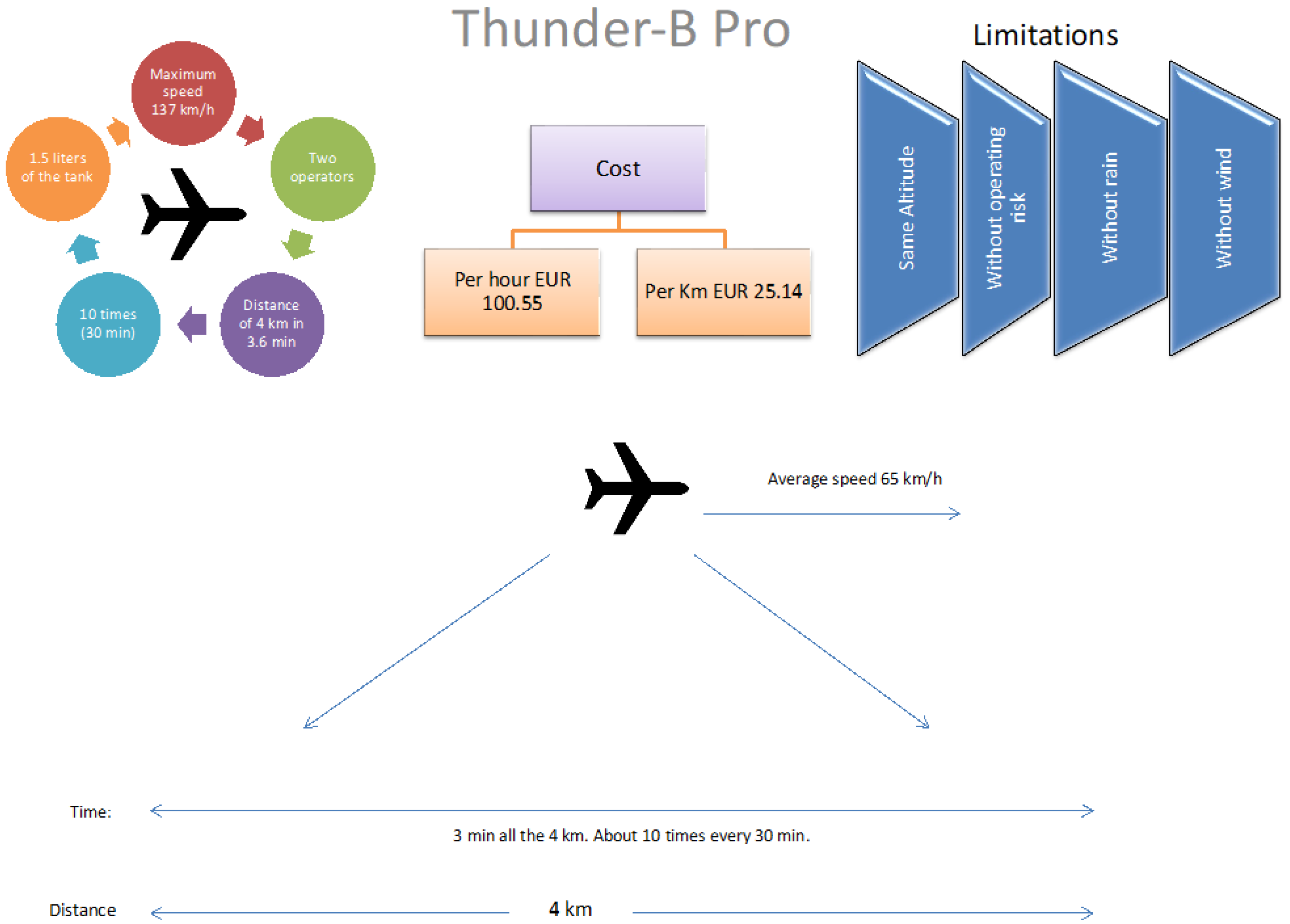
3.1. Vehicle Description and Characteristics

Phantom 4 Pro weighs 1375 gr using a 6000 mAh LiPo battery for operation and propellers for flight with 350 mm diagonal size. The battery flight capacity is about 30 min with 1.5 h of charging time. Its maximum flight time is 30 min, and its maximum wind speed resistance is 10 m/s, without rain. It has a maximum ascent speed of 5 m/s and a maximum descent speed of 4 m/s.
The purchase cost is EUR 1699. A battery replacement costs EUR 189, and a thermal camera costs about EUR 2149. The charger costs EUR 99, and the standard annual service from the mother company is EUR 169 excluding the cost of damaged spare parts [54], while the software is provided for free by the company. The lifetime of batteries varies from 300 to 500 cycles [55]. We will consider 400 charges as an average battery life in our estimations. Thunder-B is a “small tactical unmanned aerial vehicle (UAV) developed by Israeli company BlueBird Aero Systems,” which is also used by the Greek police. It weighs 32 kilograms (kg), and its flight range is 150 kilometers (km). The maximum flight altitude is 16,000 feet (ft) (4870 m), while it can remain in the air for 24 h with one fuel tank or 12 h depending on the payload, speed, and weather conditions. It has a tank of 12 liters (L), and its maximum flight speed is 32–72 knots (kt) (16–37 m/s or 60–137 km/h). Also, it can fly with an airspeed of up to 45 knots (kt) and in rain of up to 10 millimeters/hour (mm/h). The Thunder-B requires a mobile system involving hardware and sensors at different costs, depending on extras, from USD 100,000 to USD 200,000. Based on press releases, the cost of purchasing a Thunder-B system (drone, software, and hardware) is EUR 200,000. However, obtaining written cost data has not been possible, despite our efforts, for this vehicle. There should be one annual service as reported by the manufacturer.
The Phantom 4 Pro can be operated by one operator, while the Thunder-B needs two operators. The operator’s cost is calculated according to the average salary of police officers with 10 to 15 years in service, estimated at EUR 20,820 per year [56]. Table 1 summarizes the essential characteristics of the two studied vehicles.

3.2. Cost Calculation Methodology

In this section, we detail how to estimate the cost of flight time of the two vehicles, based on the unit cost. These costs will be calculated based on the Total Annual Economic Cost (TAEC) formula:
TAEC = C c × CRF + C a
The Capital Recovery Factor (CRF) is given by:
CRF = r ( 1 + r ) t ( 1 + r ) t 1
  • where Cc is the capital/purchasing cost
  • Ca is the annual operation and maintenance cost
  • t are the years of operation and
  • r the opportunity cost of capital (OCC).
By calculating the annual equivalent cost, we can refer to a unit for levelized incurred costs; that is, per kilometer or hour. Also, we considered the lifetime of a thermal camera and a charger to be 5 years, alongside the lifetime of batteries of 400 charge cycles. Each battery-charging kilowatt hour (kWh) cost is calculated according to the Greek electricity market based on March 2021 [57]. The price of fuels is EUR 1.575 based on prices in March 2021 when we ran the analysis. We consider that the speed of the drones is about the average speed reported in their manuals. Also, this study assumes that for Thunder-B, the service cost is 2.5% of the purchase cost, as no data were provided. Furthermore, we considered the number of operators that are necessary for surveillance flights. The law enforcement officer’s wage was considered to be the same for the two drones regardless of the level of operating risk or the characteristics of each drone. Finally, the basic software cost was not calculated separately because the software for the Phantom 4 Pro is free (open), and that for the Thunder-B drone is included in the purchase cost. Thus, any software or future development cost cannot be separated from the purchase or maintenance costs we have considered.

3.3. Unit Cost Calculation

In this section, we describe the basic cost elements and any assumptions considered to compare the cost of flight time of the two vehicles based on the unit cost. These costs were calculated based on the TAEC provided by Formulas 1 and 2. We considered the lifetime of the drones to be 5 and 10 years for the Phantom 4 Pro and Thunder-B, respectively, with an OCC of 5%. We also considered the Phantom 4 Pro and Thunder-B drones’ 5 km of surveillance for different flight times. This study assumes that the service cost for the Thunder-B drone is 2.5% of the purchase cost. We assume this drone can fly with one full tank for 16 h (out of the 24 h reference value). Thus, this drone needs 0.75 L of fuel per hour. The price of fuel is EUR 1.575. For the Phantom 4 Pro, one operator is necessary for half an hour of surveillance. Therefore, two operators with two vehicles are needed for surveillance flights from 1 to 8 h. The second operator will fly the second drone as soon as the first lands to change the battery, so the surveillance is uninterrupted, and vice versa. For a 10 to 16 h period, we need four operators and two vehicles, due to the second shift involved. On the other hand, a Thunder-B drone needs two operators for surveillance periods between 0.5 and 8 h and four operators (a second shift) for 8 to 16 h periods.

4. Results

This section presents analytical cost estimations for a specific 4 h trip, flight costs for different distance levels, and flight cost per hour. With this case scenario, we assume that the aggregated annual surveillance period is 1460 h if a 4h flight for each day of the year is necessary. We then calculated the cost per kilometer of flight, considering the vehicle’s travel distance capacity per time. This is an analytical approach intended for budgeting law enforcement applications. Finally, we provide a case study example based on our findings.

4.1. Cost Estimations for 4 h Flight

Considering a typical flight surveillance period of 4 h, the flight cost, with the best possible details for each of the two drone types selected, was calculated. The different needs of the necessary units for achieving the planned time flights are presented in Appendix A. The required number of units for the 4-h case, we selected to present, are shown in Table 2.

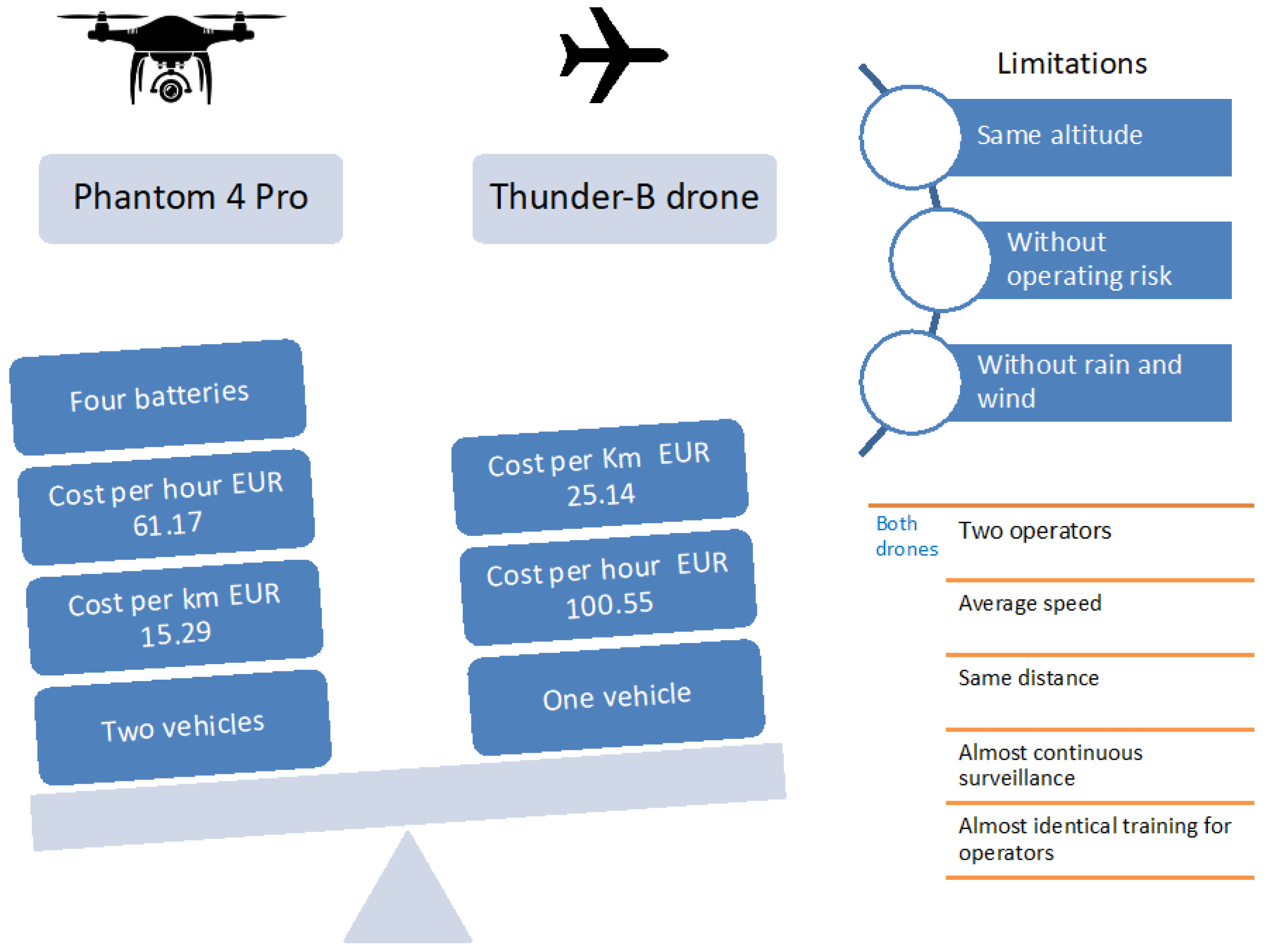
4.1.1. Cost Estimations for Phantom 4 Pro

The purchase cost for two Phantom 4 Pro drones is EUR 3398 with an estimated economic life of 5 years. The necessary cost for equipping the vehicles with two thermal cameras is EUR 4298. The cost of the batteries is EUR 1512. We need eight batteries for 4 h flight surveillance per year. After this load, they will be worn out and will have to be replaced. The cost of three chargers is EUR 297. As discussed in Section 3.2 and Section 3.3, all this equipment is necessary for 4 h uninterrupted operation. The equivalent operation and maintenance (O&M) costs of this equipment are EUR 338 for service, EUR 39.42 for energy, and EUR 41,640 for the two operators. Table 3 shows the calculations of annuitized capital and annual O&M costs, which result in a TAEC of EUR 45,451.20.
The DJI Phantom 4 Pro has a flight range of 5 km. So, the total covered kilometers are 7300 km [surveillance (1460 h), ∗ range of flight (5 km)]. Therefore, to calculate the total cost per hour, we divided the total cost by the total operating hours. The above calculation gives 45,451.20/1460 = EUR 31.13/h.

4.1.2. Cost Estimation for Thunder-B

We consider the Thunder-B drone system to have a purchase cost of EUR 200,000, with camera and software costs embedded. Based on our research methodology, we calculated the CRF and TAEC the same way as with the Phantom 4 Pro. The Thunder-B drone’s lifetime is estimated to be ten years, with two operators needed per flight. The annual service cost is estimated to be EUR 5000. The total annual cost was calculated to be EUR 25,900.91. We consider that a fuel tank is sufficient for a 16 h flight. This type of drone needs 0.75 L of fuel per hour. So, the annual fuel cost is EUR 1724.63 for 4 h flights. The cost for the four operators is the same as for the operators of the Phantom 4 Pro, equaling EUR 41,640. The annual cost is EUR 74,265.54 (Table 4).
The cost per hour and km are given if we divide the total annual cost by the total covered km and the total functional hours. With this case scenario, we concluded that the total monthly monitoring hours are 1460. The Thunder-B drone has a range of 50 km flights. So, the total covered kilometers are 73,000 km [surveillance (1460 h), ∗ range of flight (50 km)]. To calculate the total cost for the user per hour, we divide the total cost by operating hours to calculate the unit cost per hour. This gives 74,265.54/1460 = EUR 50.87/h.

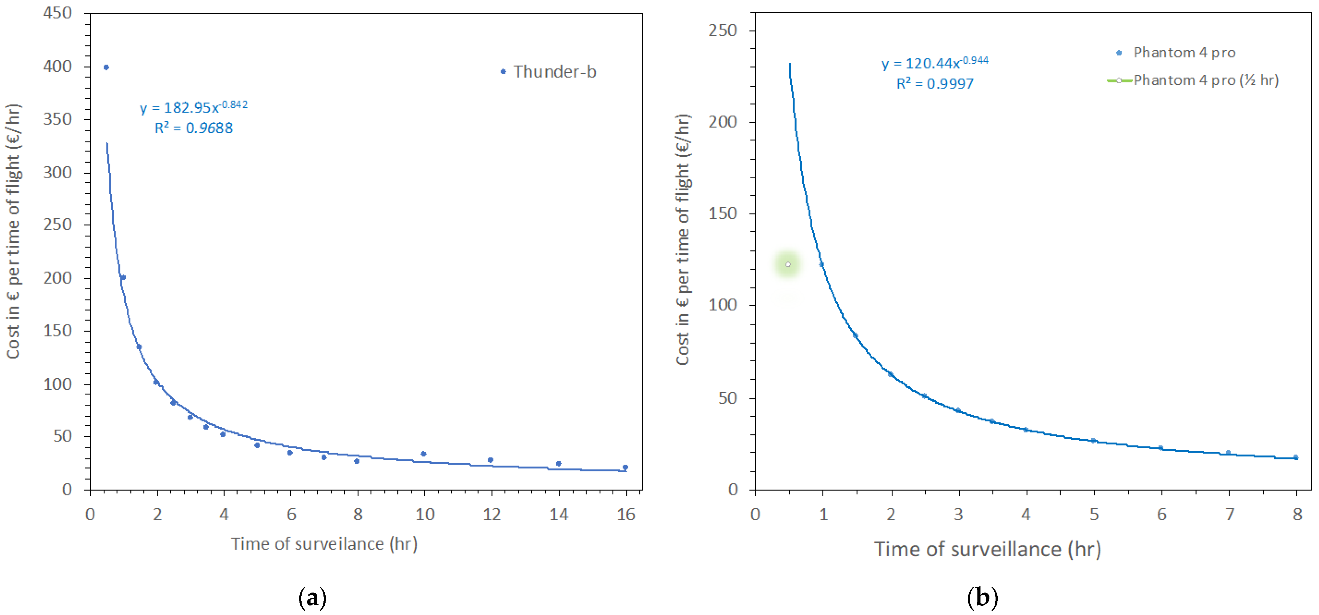
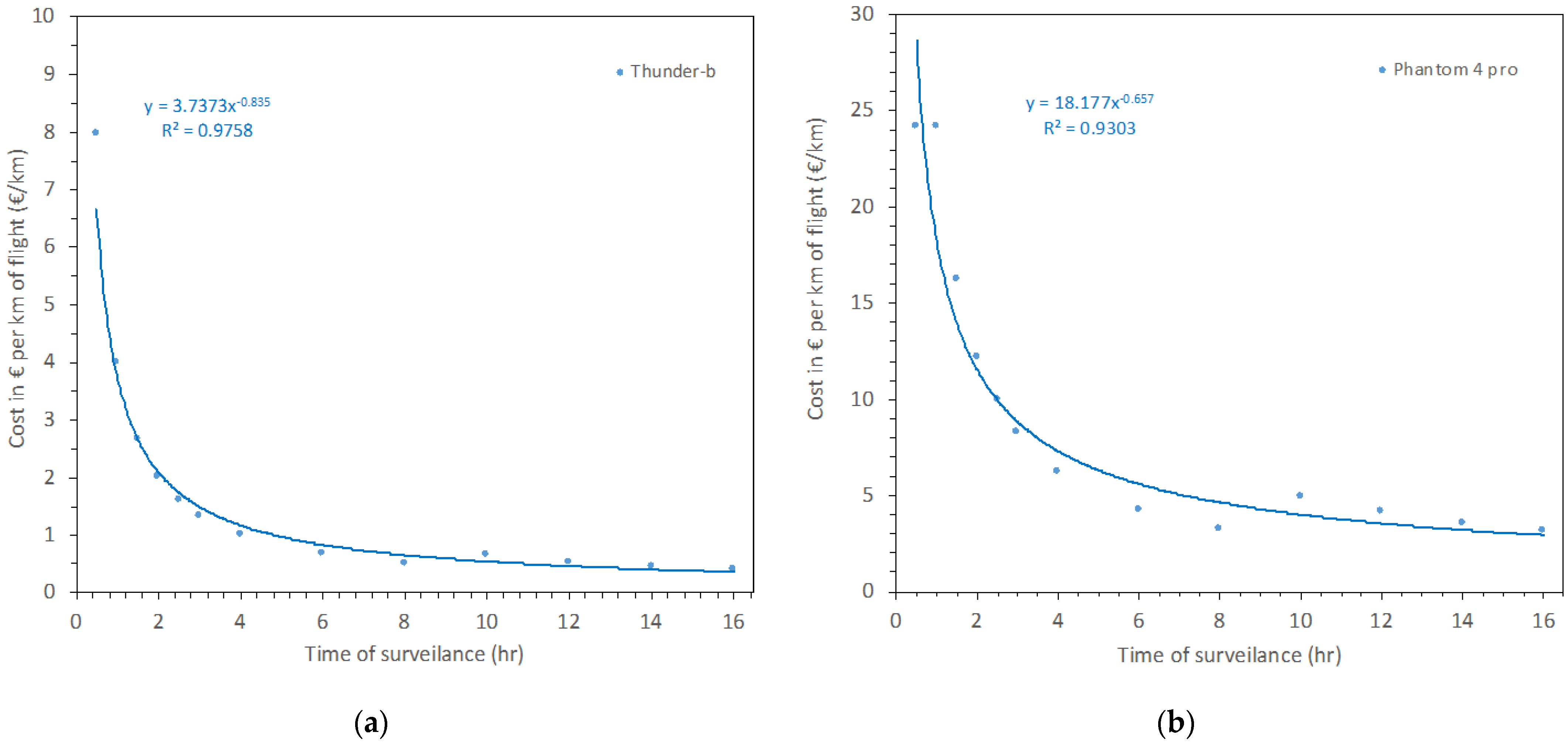
4.2. Cost Estimations per Flight Duration
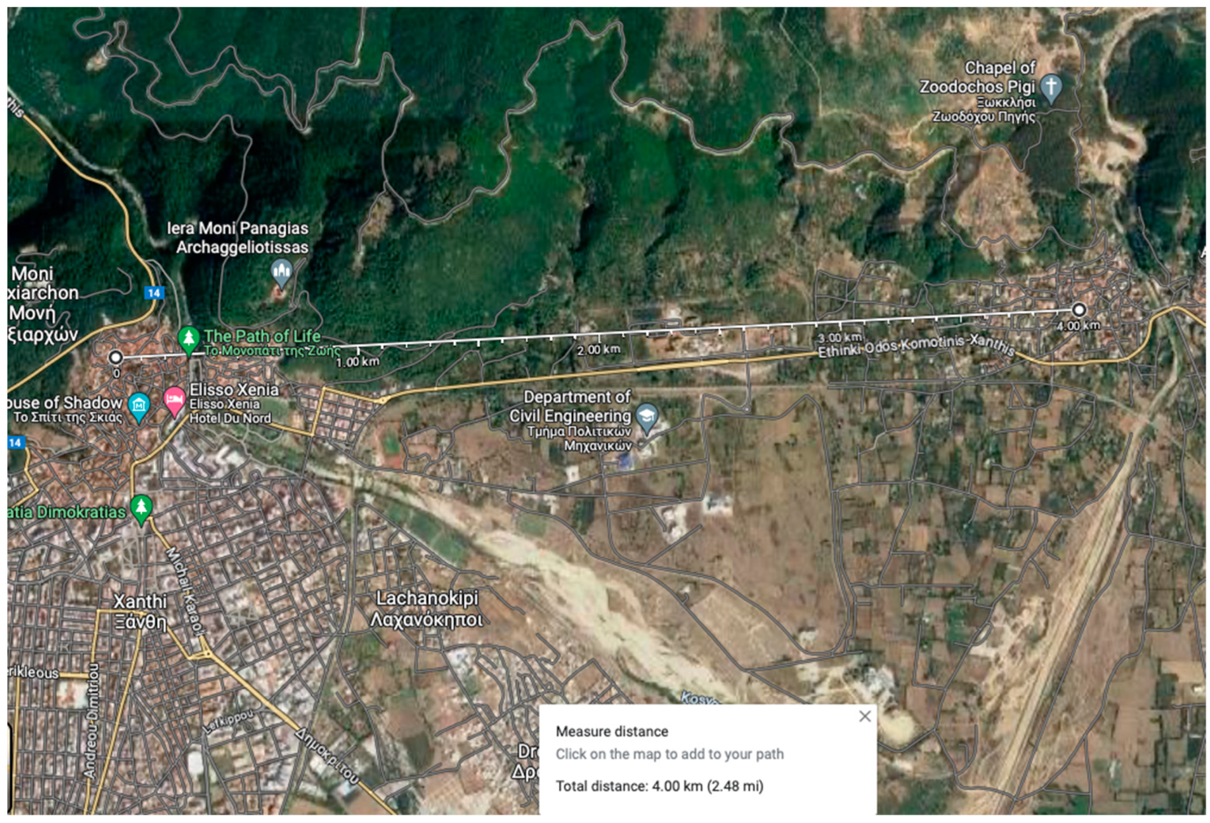
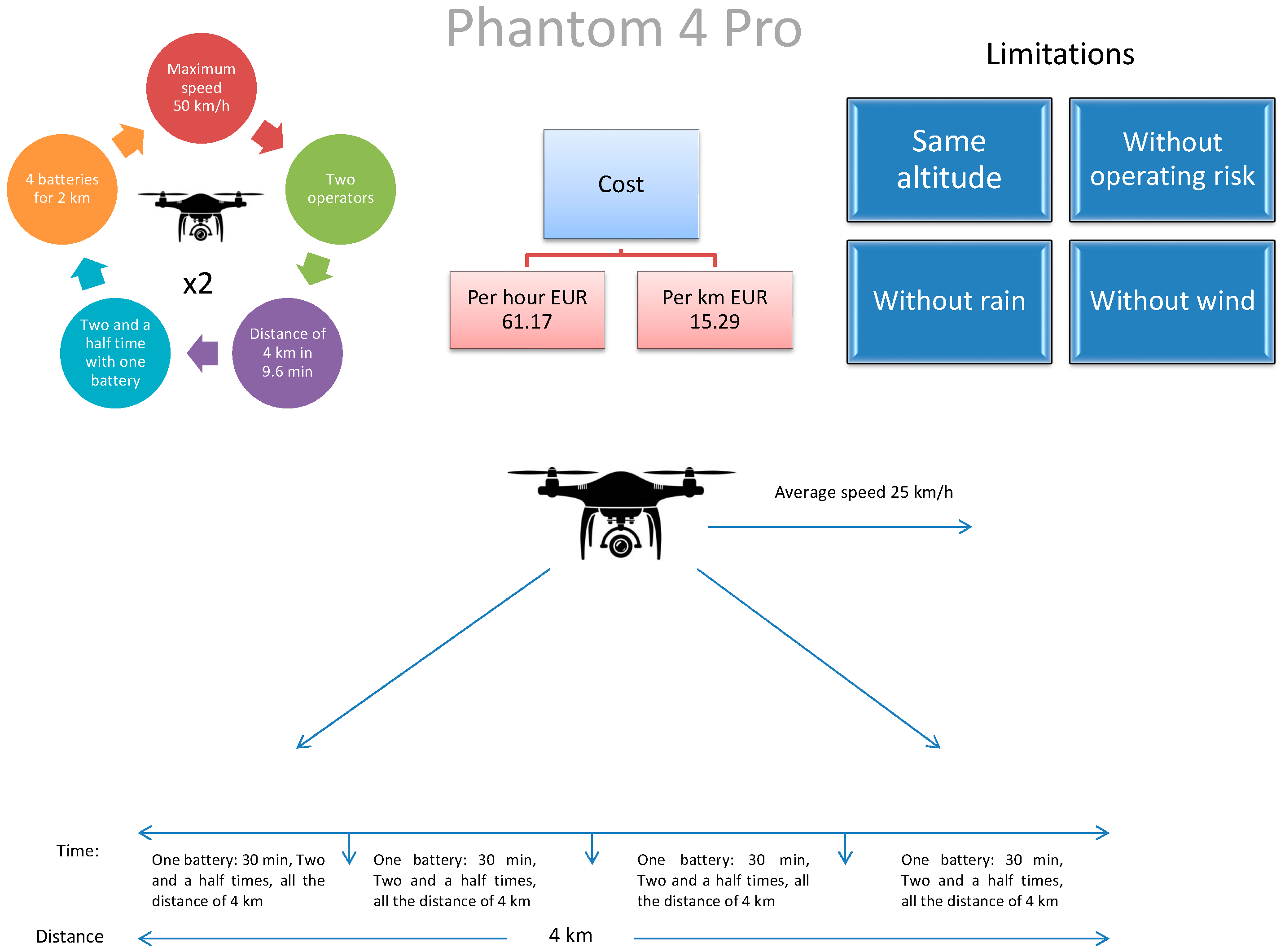
Based on the analytical estimations of the previous section, we proceeded with further calculations per flight duration from 0.5 to 16 h of surveillance per day for the Thunder-B drone (Figure 1a) and from 0.5 to 8 h of surveillance per day for the Phantom 4 Pro drone (Figure 1b). Therefore, the total annual flight times equaled 182.5, 2920, and 5840 annual hours for 0.5, 8, and 16 surveillance hours per day, respectively. Economies of scale are shown graphically and from the estimated equations of Cost = a·xb, where x is flight time or distance covered. The “b” coefficient was estimated with a negative sign for both equations due to the aforementioned economies of scale. All calculations followed the fitted equations except for the 0.5 h surveillance period with the Phantom 4 Pro drone, as observed in Figure 1. We believe that a 0.5 h flight is a short period compared to the analysis we performed, and it is calculated separately; thus, it does not contribute to the regression of Figure 1. If we take, for example, the cost of surveillance for a 1 h trip, we see that the cost drops from about EUR 200/h to about EUR 100/h if the trip lasts 2 h for the Thunder-B.
Similarly, the cost of surveillance for a one-hour trip and two two-hour trips is about EUR 122 and EUR 62, respectively, for the Phantom 4 Pro drone. However, it is evident that the Phantom 4 Pro costs less than the Thunder-B for all calculated times. Figure 1 shows an excellent rapid cost estimation for different surveillance trips.
In Figure 2, we calculated the cost of surveillance per km based on the drones’ typical average speeds. We calculated the cost per km for the Thunder-B drone when the trip lasts 50 km (Figure 2a). On the other hand, we calculated the cost per km for the Phantom 4 Pro drone when the trip lasts 5 km (Figure 2b). All points fit the equations Cost = a·xb, with similar evidence of economies of scale. In this case, the cost per kilometer for the Phantom 4 Pro drone is higher than that for the Thunder-B drone at all points. For example, 4 h of surveillance will cost EUR 1.02 per kilometer for a Thunder-B drone, while a Phantom 4 Pro drone will cost EUR 6.23 per kilometer. Although the two vehicles may be used for different applications, we present these values as an example of comparison and how this methodology can help estimate service costs.

4.3. Case Study

In our case study of surveillance by the enforcement authorities, we selected a small area in Xanthi, city, located in Greece. We used the two drones analyzed in the previous section. The 4 km surveillance area is shown in Figure 3, as an abstract from google maps. The line shows the distance, starting from the old town of Xanthi, crossing the Kosinthos River, a peri-urban grove of trees, and ending in the village of Kimmeria. The peri-urban grove of trees and river constitute a small sample of flora and fauna of the region.
The surveillance time lasted for 2 h per day of scoping to ensure compliance with environmental legislation in this area. The surveillance aimed to provide identification of perpetrators of littering, setting fire to the grove, and polluting the Kosinthos water body.
In this case study, the distance was short, and we needed two Phantom 4 Pro drones with four batteries for two hours of uninterrupted surveillance. One battery lasts 30 min and needs charging for 1.5 h. The maximum speed of the Phantom 4 Pro is 50 km/h. If we fly the Phantom 4 Pro with an average speed of 25 km/h, it will cover the distance of 4 km in 9.6 min. So, the Phantom 4 Pro drone surveillance will be able to cover the distance two and a half times with one battery charge. The journey is short and the surveillance will be almost continuous. Therefore, for two hours of surveillance in this area, four Phantom 4 Pro batteries per day, two vehicles, two operators, two thermal cameras, and three chargers are necessary to retain the flying capacity. The summary of employing the Phantom 4 Pro drone for this case study is presented in Figure 4. We also state the limitations of our assumptions; that is, that there will be surveillance from a specified height, no significant winds or precipitations, and no other risks (i.e., operating risk), which would inevitably affect costs.
On the other hand, we needed one Thunder-B drone for two hours of surveillance. Also, a 1.5 L tank and two operators are necessary. The maximum speed of the Thunder-B drone is 137 km/h. In this case, the drone can fly at a recommended cruise speed of 80 km/h (note that 66 km/h speed is the minimum possible cruise speed). Under these circumstances, it will cover a distance of 4 km in 3.6 min. So, using the Thunder-B drone for will cover the distance faster than the Phantom 4 Pro, but the time period is also short, so the surveillance is continuous. The summary of employing the Thunder-B drone for this case study is presented in Figure 5.
Using the functions from Section 3.2, we assume the costs for one-year surveillance. In this case, the cost of the Phantom 4 Pro per hour is EUR 61.17 and per kilometer is EUR 15.29, while the cost of the Thunder-B drone per hour is EUR 100.55 and per kilometer is EUR 25.14.
This approach has some limitations. The flight will occur at the same altitude, assuming no operating or personal risk. We accepted that flights would occur in clear weather without rain and wind. The software cost was not calculated separately as discussed, and we assumed no critical accidents would occur.
As noticed, the cost of the two drones is quite different. The cost of the Phantom 4 Pro is lower than that of the Thunder-B, while surveillance is continuous for both vehicles. We are thus able to select the first drone because it has a lower cost (Figure 6). The cost is reasonable compared to traditional methods of monitoring; for instance, with patrol cars. Furthermore, when observation is continuous, violation of the law can be minimized, and law enforcement officers using drones are more efficient. On the other hand, law enforcement officers can save time and operate in a safer working environment, and perpetrator identification is faster. Finally, in the case of a drone accident, the damage is limited to equipment and not to human lives.

5. Discussion

In this work, we compared and levelized costs for two drones, the Phantom 4 Pro and Thunder-B, used for surveillance. The calculated cost for these drones concerns their use and not the total ownership. Valerdi [51] proposed that cost depends on weight and endurance calculated on pound/hour per thousand dollars. On the other hand, Malone et al. [52] described an estimation of total ownership cost for UAV systems. In this work, we calculated the unit cost of drones to be able to compare them.
We analyzed the operating cost for each drone’s different time durations and distances. We observed that if the surveillance hours increased, the operating cost for these drones decreased due to economies of scale. The cost per kilometer constantly decreased if the km covered increased. On the other hand, we saw that the operating cost of the Phantom 4 Pro drone was lower than that of the Thunder-B drone. As shown in Figure 1, the cost of one or two hours of surveillance for a Phantom 4 Pro drone is lower than that for a Thunder-B drone. For Phantom 4 Pro, we conducted our analysis used batteries that last for half an hour and then should be replaced once the drone has landed.
Furthermore, there are additional restrictions on adverse weather conditions. The Phantom 4 Pro cannot fly in rain, snow, or wind. In contrast, Thunder-B drones can operate in rainy and windy conditions. Combining the covered distance with a fuel tank leads us to conclude that this drone covers more are than the smaller Phantom 4 Pro drone. As revealed from the cost analysis, the Thunder-B drone is cost-effective for large uninterrupted missions for up to 16 h of surveillance.
As revealed from the case study, for 2 h of constant surveillance in an area of 4 km distance with the examined drones, the cost with Phantom 4 Pro was EUR 61.17/h or EUR 15.29/km, while with the Thunder-B drone, the equivalent costs were EUR 100.55/h and EUR 25.14/km, respectively. The analysis we performed for this case study also has some limitations. We considered the same altitude, average speed, no operating risks or accidents, and ideal environmental conditions. The average speed of these drones differs based on the reference range. The cost is lower for the Phantom 4 Pro than for the Thunder-B, so we selected the first one based only on cost figures (Figure 6).
Employing drones for surveillance can add an extra cost for law enforcement agencies. Still, this case study shows that the cost is reasonable and can be more efficient than conventional methods. We assumed continuous surveillance without operational accidents or risks. On the other hand, law enforcement officers can save time via faster and more efficient drone monitoring in place of conventional patrolling. Real-time data collection is a significant aid for law enforcement officers in many sections, such as perpetrator identification, recognition of missing people, environmental monitoring in real time, aviation environmental violations, prevention of air pollution, or water rescues and disaster response. Drones are increasingly applied in various fields for law enforcement officers. So, their working efficiency is high in terms of safety and surveillance. The working environment is also safer because drone use decreases potential personnel risks. For example, if a drone crashes, the cost is lower than that of a human-crewed helicopter, where the pilot’s life is the highest protected good in all societies. UAV technology helps to fight crime in a cost-effective manner. Law enforcement policymakers should include aerial surveillance in crime prevention programs. Indeed, there are also issues about the use of drones [40], especially concerns about the violation of human rights, which will not be analyzed here but only mentioned as there is an ongoing debate.
Data availability is a limitation of this work. We also recognize some further limitations on assumptions made on operating cost, altitude, average speed, environmental conditions, personal risk, and environmental impact, as the operating costs depend on these factors. Significantly, the cost will increase if the altitude of the drone flight is higher than calculated because the drone will need more energy. In the same way, if the speed is increased or the wind is strong, the drone requires more power for the same flight. Also, accidents will increase costs because if drones crash or land accidentally, further repair work and spare parts are necessary. Additionally, the cost will be increased if the environment is challenging (e.g., complex landscapes, rivers, or topography).
Moreover, the Phantom 4 Pro battery lifetime is considered to be 400 cycles. The basic software cost was not calculated separately because the software for Phantom 4 Pro is free (open) and the software for the Thunder-B drone is included in the purchase cost. Thus, any software or future development cost cannot be separated from the purchase or maintenance costs we have considered. Furthermore, there are no available real data for costs related to cyber security, navigation, software, and the impact of accidents; we excluded it to ensure our calculations were clear and feasible. Additionally, a law enforcement officer’s wage was considered the same for the two drones regardless of the level of operating risk or the characteristics of each drone, which is the case in the region of our case study. Note that by this, we do not mean to oversimplify our approach, but to provide a practical and integrated way to obtain reasonable cost estimations and comparisons. Nevertheless, any assumptions are based on the available data and experience since no previous studies have analyzed the cost of using drones. Most researchers analyze the unit cost from the perspective of construction and ownership purchase rather than from their use. Cost values based on the data provided by the companies should be further validated with statistical and empirical findings following the extended use of the studied models. Also, the fast improvement of UAV technology itself may render the concluded costs outdated soon. Nevertheless, valid economic conclusions can be drawn by applying the same principles in this work.

6. Conclusions

The use of drones by law enforcement has been increasing in recent years. Some law enforcement applications need to be constantly observed, while others are partial. Economic analysis is essential for all purposes, as well as for security forces to be able to budget surveillance duties in advance. We describe a methodology that can be used for calculating levelized costs per flight time or distance covered and produce equations for further calculations. These equations show economies of scale in flight time and vehicle size. Economic data are necessary to integrate UAV technology into operational activities for entrepreneurial and security protection. Our case study shows that drones can be cost-effective for law enforcement monitoring. As an example, we showed how to estimate the monitoring cost. Last but not least, policymakers could include UAV technology in crime prevention programs.
To our knowledge, this study is the first economic analysis of drone use employing real data on a life-cycle cost basis. Suggestions for future works include keeping detailed records of all fixed and variable costs to produce more informative equations for more vehicles. Also, flight records under different weather conditions can add more precision to the estimations. Another suggestion that will pay off is training users and creating a repository of cost data from different vehicles. Finally, further research should involve the comparison of these findings with other conventional means of surveillance.

Author Contributions

N.T. conceived the idea; N.T. collected and decoded the data; N.T. and K.P.T. performed the analysis; N.T., L.E., and K.P.T. wrote the paper. All authors have read and agreed to the published version of the manuscript.

Funding

This research received no external funding.

Data Availability Statement

Available upon request.

Conflicts of Interest

The authors declare no conflict of interest.

Appendix A

This appendix provides the necessary unit components for uninterrupted surveillance time flights of 0.5–16 h duration for the Phantom 4 Pro (Table A1) and Thunder-B (Table A2).
Table A1. Necessary units for a continuous flight for Phantom 4 Pro.
HoursMachines 11 00983 i0080.511.522.533.54567810121416
Batteries per yearMachines 11 00983 i009223488881212161620242832
DronesMachines 11 00983 i0011222222222222222
PersonnelMachines 11 00983 i0101222222222224444
CameraMachines 11 00983 i0031222222222222222
ChargerMachines 11 00983 i0071123333333333333
Table A2. Necessary units for a continuous flight for Thunder-B.
Hours
UnitsMachines 11 00983 i0080.511.522.534810121416
FuelMachines 11 00983 i005 = 1 L0.3750.751.1251.51.8752.25367.5910.516.2
DroneMachines 11 00983 i002111111111111
PersonnelMachines 11 00983 i004222222224444

References

  1. Merz, M.; Pedro, D.; Skliros, V.; Bergenhem, C.; Himanka, M.; Houge, T.; Matos-Carvalho, J.P.; Lundkvist, H.; Cürüklü, B.; Hamrén, R.; et al. Autonomous UAS-Based Agriculture Applications: General Overview and Relevant European Case Studies. Drones 2022, 6, 128. [Google Scholar] [CrossRef]
  2. Mohsan, S.A.H.; Khan, M.A.; Noor, F.; Ullah, I.; Alsharif, M.H. Towards the Unmanned Aerial Vehicles (UAVs): A Comprehensive Review. Drones 2022, 6, 147. [Google Scholar] [CrossRef]
  3. Saranya, C.; Pavithira, L.; Premsai, N.; Lavanya, H.; Govindarajan, R. Recent Trends of Drones in the Field of Defense. Int. J. Electr. Appl. 2015, 1, 47–55. [Google Scholar]
  4. Klemas, V.V. Coastal and Environmental Remote Sensing from Unmanned Aerial Vehicles: An Overview. J. Coast. Res. 2015, 31, 1260–1267. [Google Scholar] [CrossRef]
  5. Bossoukpe, M.; Faye, E.; Ndiaye, O.; Diatta, S.; Diatta, O.; Diouf, A.A.; Dendoncker, M.; Assouma, M.H.; Taugourdeau, S. Low-Cost Drones Help Measure Tree Characteristics in the Sahelian Savanna. J. Arid Environ. 2021, 187, 104449. [Google Scholar] [CrossRef]
  6. Manfreda, S.; McCabe, M.F.; Miller, P.E.; Lucas, R.; Pajuelo Madrigal, V.; Mallinis, G.; Ben Dor, E.; Helman, D.; Estes, L.; Ciraolo, G. On the Use of Unmanned Aerial Systems for Environmental Monitoring. Remote Sens. 2018, 10, 641. [Google Scholar] [CrossRef]
  7. Lloret, J.; Garcia, M.; Bri, D.; Sendra, S. A Wireless Sensor Network Deployment for Rural and Forest Fire Detection and Verification. Sensors 2009, 9, 8722–8747. [Google Scholar] [CrossRef]
  8. Lawlor, K.; Olander, L.; Boyd, W.; Niles, J.; Madeira, E. Addressing the Causes of Tropical Deforestation: Lessons Learned and the Implications for International Forest Carbon Policy; International Forest Carbon and the Climate Change Challenge Series—Brief Number 5 June; Nicholas Institute for Environmental Policy Solutions, Duke University: Durham, NC, USA, 2009. [Google Scholar]
  9. Balcerzak, A.T.; Jasiuk, B.E.; Fellner, C.A.; Feltynowski, D.M. The Polish Perspective of Using Unmanned Aerial Vehicle Systems in International Firefighting and Crisis Management Missions—Legal and Technological Analysis. In Proceedings of the 2021 International Conference on Unmanned Aircraft Systems (ICUAS), Athens, Greece, 15–18 June 2021; pp. 1478–1487. [Google Scholar]
  10. Herwitz, S.R.; Johnson, L.F.; Dunagan, S.E.; Higgins, R.G.; Sullivan, D.V.; Zheng, J.; Lobitz, B.M.; Leung, J.G.; Gallmeyer, B.A.; Aoyagi, M.; et al. Imaging from an Unmanned Aerial Vehicle: Agricultural Surveillance and Decision Support. Comput. Electron. Agric. 2004, 44, 49–61. [Google Scholar] [CrossRef]
  11. Han, L.; Yang, G.; Yang, H.; Xu, B.; Li, Z.; Yang, X. Clustering Field-Based Maize Phenotyping of Plant-Height Growth and Canopy Spectral Dynamics Using a UAV Remote-Sensing Approach. Front. Plant Sci. 2018, 9, 1638. [Google Scholar] [CrossRef]
  12. Shafian, S.; Rajan, N.; Schnell, R.; Bagavathiannan, M.; Valasek, J.; Shi, Y.; Olsenholler, J. Unmanned Aerial Systems-Based Remote Sensing for Monitoring Sorghum Growth and Development. PLoS ONE 2018, 13, e0196605. [Google Scholar] [CrossRef]
  13. Ronchetti, G.; Mayer, A.; Facchi, A.; Ortuani, B.; Sona, G. Crop Row Detection through UAV Surveys to Optimize On-Farm Irrigation Management. Remote Sens. 2020, 12, 1967. [Google Scholar] [CrossRef]
  14. Mora, A.; Vemprala, S.; Carrio, A.; Saripalli, S. Flight Performance Assessment of Land Surveying Trajectories for Multiple UAV Platforms. In Proceedings of the 2015 Workshop on Research, Education and Development of Unmanned Aerial Systems (RED-UAS), Cancun, Mexico, 23–25 November 2015; IEEE: Piscataway, NJ, USA, 2015; pp. 1–7. [Google Scholar] [CrossRef]
  15. Albetis, J.; Jacquin, A.; Goulard, M.; Poilvé, H.; Rousseau, J.; Clenet, H.; Dedieu, G.; Duthoit, S. On the Potentiality of UAV Multispectral Imagery to Detect Flavescence Dorée and Grapevine Trunk Diseases. Remote Sens. 2019, 11, 23. [Google Scholar] [CrossRef]
  16. Riniatsih, I.; Ambariyanto, A.; Yudiati, E.; Redjeki, S.; Hartati, R. Monitoring the Seagrass Ecosystem Using the Unmanned Aerial Vehicle (UAV) in Coastal Water of Jepara. Proc. IOP Conf. Ser. Earth Environ. Sci. 2021, 674, 012075. [Google Scholar] [CrossRef]
  17. Półka, M.; Ptak, S.; Kuziora, Ł. The Use of UAV’s for Search and Rescue Operations. Procedia Eng. 2017, 192, 748–752. [Google Scholar] [CrossRef]
  18. Griffin, G.F. The Use of Unmanned Aerial Vehicles for Disaster Management. Geomatica 2014, 68, 265–281. [Google Scholar] [CrossRef]
  19. Zulkipli, M.A.; Tahar, K.N. Multirotor UAV-Based Photogrammetric Mapping for Road Design. Int. J. Opt. 2018, 2018, 1871058. [Google Scholar] [CrossRef]
  20. Koeva, M.; Muneza, M.; Gevaert, C.; Gerke, M.; Nex, F. Using UAVs for Map Creation and Updating. A Case Study in Rwanda. Surv. Rev. 2018, 50, 312–325. [Google Scholar] [CrossRef]
  21. Giordan, D.; Adams, M.S.; Aicardi, I.; Alicandro, M.; Allasia, P.; Baldo, M.; De Berardinis, P.; Dominici, D.; Godone, D.; Hobbs, P.; et al. The Use of Unmanned Aerial Vehicles (UAVs) for Engineering Geology Applications. Bull. Eng. Geol. Environ. 2020, 79, 3437–3481. [Google Scholar] [CrossRef]
  22. Smith, S.L. Drones over the “Black Desert”: The Advantages of Rotary-Wing UAVs for Complementing Archaeological Fieldwork in the Hard-to-Access Landscapes of Preservation of North-Eastern Jordan. Geosciences 2020, 10, 426. [Google Scholar] [CrossRef]
  23. Leuenberger, D.; Haefele, A.; Omanovic, N.; Fengler, M.; Martucci, G.; Calpini, B.; Fuhrer, O.; Rossa, A. Improving High-Impact Numerical Weather Prediction with Lidar and Drone Observations. Bull. Am. Meteorol. Soc. 2020, 101, E1036–E1051. [Google Scholar] [CrossRef]
  24. Stanton, M.C.; Kalonde, P.; Zembere, K.; Hoek Spaans, R.; Jones, C.M. The Application of Drones for Mosquito Larval Habitat Identification in Rural Environments: A Practical Approach for Malaria Control? Malar. J. 2021, 20, 244. [Google Scholar] [CrossRef] [PubMed]
  25. Kunovjanek, M.; Wankmüller, C. Containing the COVID-19 Pandemic with Drones—Feasibility of a Drone Enabled Back-up Transport System. Transp. Policy 2021, 106, 141–152. [Google Scholar] [CrossRef] [PubMed]
  26. Massarelli, C.; Muolo, M.R.; Uricchio, V.F.; Dongiovanni, N.; Palumbo, R. Improving Environmental Monitoring against the Risk from Uncontrolled Abandonment of Waste Containing Asbestos. The DroMEP Project. Geomatics Workbooks n° 12—“FOSS4G Europe Como 2015”. Available online: https://www.researchgate.net/profile/Carmine-Massarelli/publication/281811563_Improving_environmental_monitoring_against_the_risk_from_uncontrolled_abandonment_of_waste_containing_asbestos_The_DroMEP_project/links/6124d74b0c2bfa282a6707c4/Improving-environmental-monitoring-against-the-risk-from-uncontrolled-abandonment-of-waste-containing-asbestos-The-DroMEP-project.pdf (accessed on 17 September 2023).
  27. Cheteni, P. An Analysis of Anti-Poaching Techniques in Africa: A Case of Rhino Poaching. Environ. Econ. 2014, 5, 63–70. [Google Scholar]
  28. Boakye, J. Enforcement of Logging Regulations in Ghana: Perspectives of Frontline Regulatory Officers. For. Policy Econ. 2020, 115, 102138. [Google Scholar] [CrossRef]
  29. Zhou, F.; Pan, S.; Chen, W.; Ni, X.; An, B. Monitoring of Compliance with Fuel Sulfur Content Regulations through Unmanned Aerial Vehicle (UAV) Measurements of Ship Emissions. Atmos. Meas. Tech. 2019, 12, 6113–6124. [Google Scholar] [CrossRef]
  30. Golcarenarenji, G.; Martinez-Alpiste, I.; Wang, Q.; Alcaraz-Calero, J.M. Efficient Real-Time Human Detection Using Unmanned Aerial Vehicles Optical Imagery. Int. J. Remote Sens. 2021, 42, 2440–2462. [Google Scholar] [CrossRef]
  31. Rosenfeld, A. Are Drivers Ready for Traffic Enforcement Drones? Accid. Anal. Prev. 2019, 122, 199–206. [Google Scholar] [CrossRef]
  32. Marin, L.; Krajčíková, K. Deploying Drones in Policing Southern European Borders: Constraints and Challenges for Data Protection and Human Rights. In Drones and Unmanned Aerial Systems; Springer: Berlin/Heidelberg, Germany, 2016; pp. 101–127. [Google Scholar]
  33. Daniels, J. (Doug) Drones for Police, Fire & Other Emergency Responders Senior Law Enforcement Training Officer Remote Pilot-In-Command Ohio Peace Officer Training Academy Direct Line: (740) 845-6304. Available online: https://ceas.uc.edu/content/dam/aero/docs/fire/DRONES%20FOR%20POLICE%2C%20FIRE%20%26%20OTHER%20EMERGENCY.pdf (accessed on 30 May 2021).
  34. Police Using Scentroid’s Drone Environmental Monitoring to Combat Smog. Canada, 22 February 2018. Available online: https://scentroid.com/police-using-scentroid-dr1000-flying-lab-to-combat-smog/ (accessed on 4 February 2021).
  35. Pyzynski, M. Cybersecurity of the Unmanned Aircraft System (UAS). In Proceedings of the 2020 International Conference on Unmanned Aircraft Systems (ICUAS), Athens, Greece, 1–4 September 2020; pp. 1265–1269. [Google Scholar]
  36. Bassi, E. From Here to 2023: Civil Drones Operations and the Setting of New Legal Rules for the European Single Sky. J. Intell. Robot. Syst. 2020, 100, 493–503. [Google Scholar] [CrossRef]
  37. Konert, A.; Dunin, T. A Harmonized European Drone Market?—New EU Rules on Unmanned Aircraft Systems. Adv. Sci. Technol. Eng. Syst. J. 2020, 5, 93–99. [Google Scholar] [CrossRef]
  38. ΕΛΙΣΜΕ ΓΕΕΘA 20181127 1.2 Δημήτριος Γκριτζάπης «Επιχειρησιακή Δράση ΣμηΕA Στην ΕΛ.AΣ.». Available online: https://www.slideshare.net/helissme/20181127-12 (accessed on 4 February 2021).
  39. Tα Hλεκτρονικά “Γεράκια” Της ΕΛ.AΣ. Available online: https://www.zougla.gr/greece/article/i-enaeri-filakes-kata-tou-eglimatos (accessed on 5 February 2021).
  40. Tsiamis, N.; Efthymiou, L.; Tsagarakis, K.P. A Comparative Analysis of the Legislation Evolution for Drone Use in OECD Countries. Drones 2019, 3, 75. [Google Scholar] [CrossRef]
  41. Sudbury, A.W.; Hutchinson, E.B. A Cost Analysis of Amazon Prime Air (Drone Delivery). J. Econ. Educ. 2016, 16, 1–12. [Google Scholar]
  42. Wright, C.; Rupani, S.; Nichols, K.; Yasmin, C.; Matiko, M. What Should You Deliver by Unmanned Aerial Systems? JSI Research & Training Institute, Inc.: Arlington, VA, USA, 2018. [Google Scholar]
  43. Ochieng, W.O.; Ye, T.; Scheel, C.; Lor, A.; Saindon, J.; Yee, S.L.; Meltzer, M.I.; Kapil, V.; Karem, K. Uncrewed Aircraft Systems versus Motorcycles to Deliver Laboratory Samples in West Africa: A Comparative Economic Study. Lancet Glob. Health 2020, 8, e143–e151. [Google Scholar] [CrossRef] [PubMed]
  44. Meier, P.; Bergelund, J. Field-Testing the First Cargo Drone Deliveries in the Amazon Rainforest; WeRobotics: Geneva, Switzerland, 2017. [Google Scholar]
  45. Sozzi, M.; Kayad, A.; Gobbo, S.; Cogato, A.; Sartori, L.; Marinello, F. Economic Comparison of Satellite, Plane and UAV-Acquired NDVI Images for Site-Specific Nitrogen Application: Observations from Italy. Agronomy 2021, 11, 2098. [Google Scholar] [CrossRef]
  46. Yowtak, K.; Imiola, J.; Andrews, M.; Cardillo, K.; Skerlos, S. Comparative Life Cycle Assessment of Unmanned Aerial Vehicles, Internal Combustion Engine Vehicles and Battery Electric Vehicles for Grocery Delivery. Procedia CIRP 2020, 90, 244–250. [Google Scholar] [CrossRef]
  47. Christensen, B.R. Use of UAV or Remotely Piloted Aircraft and Forward-Looking Infrared in Forest, Rural and Wildland Fire Management: Evaluation Using Simple Economic Analysis. N. Z. J. For. Sci. 2015, 45, 16. [Google Scholar] [CrossRef]
  48. Zailani, M.A.; Azma, R.Z.; Aniza, I.; Rahana, A.R.; Ismail, M.S.; Shahnaz, I.S.; Chan, K.S.; Jamaludin, M.; Mahdy, Z.A. Drone versus Ambulance for Blood Products Transportation: An Economic Evaluation Study. BMC Health Serv. Res. 2021, 21, 1308. [Google Scholar] [CrossRef]
  49. Borghetti, F.; Caballini, C.; Carboni, A.; Grossato, G.; Maja, R.; Barabino, B. The Use of Drones for Last-Mile Delivery: A Numerical Case Study in Milan, Italy. Sustainability 2022, 14, 1766. [Google Scholar] [CrossRef]
  50. White, S.M.; Schaefer, M.; Barfield, P.; Cantrell, R.; Watson, G.J. Cost Benefit Analysis of Survey Methods for Assessing Intertidal Sediment Disturbance: A Bait Collection Case Study. J. Environ. Manag. 2022, 306, 114386. [Google Scholar] [CrossRef]
  51. Valerdi, R. Cost Metrics for Unmanned Aerial Vehicles. In Infotech@ Aerospace; Massachusetts Institute of Technology: Cambridge, MA, USA, 2005; p. 7102. [Google Scholar]
  52. Malone, P.; Apgar, H.; Stukes, S.; Sterk, S. Unmanned Aerial Vehicles Unique Cost Estimating Requirements. In Proceedings of the 2013 IEEE Aerospace Conference, Big Sky, MT, USA, 2–9 March 2013; IEEE: Piscataway, NJ, USA, 2013; pp. 1–8. [Google Scholar]
  53. Banazadeh, A.; Jafari, M.H. A Heuristic Complexity-Based Method for Cost Estimation of Aerospace Systems. Proc. Inst. Mech. Eng. Part G J. Aerosp. Eng. 2013, 227, 1685–1700. [Google Scholar] [CrossRef]
  54. DJI Phantom 4 Pro. Available online: https://www.dji.com/gr/phantom-4-pro/info#specs (accessed on 20 February 2021).
  55. What’s the Best Battery? Available online: https://batteryuniversity.com/article/whats-the-best-battery (accessed on 20 March 2021).
  56. Aνάλυση Του Μισθολόγιου Των Aστυνομικών. Available online: http://policenet.gr/article/%CE%B1%CE%BD%CE%AC%CE%BB%CF%85%CF%83%CE%B7-%CF%84%CE%BF%CF%85-%CE%BC%CE%B9%CF%83%CE%B8%CE%BF%CE%BB%CF%8C%CE%B3%CE%B9%CE%BF%CF%85-%CF%84%CF%89%CE%BD-%CE%B1%CF%83%CF%84%CF%85%CE%BD%CE%BF%CE%BC%CE%B9%CE%BA%CF%8E%CE%BD (accessed on 3 March 2021).
  57. Υπολογισμός Κόστους Hλεκτρικές Ενέργειας Για Κάθε Oικιακή Συσκευή. Available online: https://www.helppost.gr/dei/ypologismos-reuma-katanalosi/ (accessed on 25 March 2021).
Figure 1. Cost per time-of-flight (a): Thunder-B drone and (b): Phantom 4 Pro drone.
Machines 11 00983 g001
Figure 2. Cost per km of flight for (a): Thunder-B drone (50 km surveillance) and (b): Phantom 4 Pro drone (5 km surveillance).
Machines 11 00983 g002
Figure 3. Surveillance area, from the old town of Xanthi to Kimmeria village.
Machines 11 00983 g003
Figure 4. Surveillance with Phantom 4 Pro.
Machines 11 00983 g004
Figure 5. Surveillance with Thunder-B drone.
Machines 11 00983 g005
Figure 6. Comparison between Phantom 4 Pro and Thunder-B drones.
Machines 11 00983 g006
Table 1. Characteristics of Phantom 4 Pro and Thunder-B drones.
UAV CharacteristicsPhantom 4 ProThunder-B
Wingspan350 mm4 m
Weight1.375 kg32 kg
Maximum speedS-mode: 45 mph (72 kph)
P-mode: 31 mph (50 kph)
137 kph
Cruise speed 80 kph
Flight range5 km150 km
Endurance30 minup to 24 h/12 h with cargo capsules/vtol
Operating altitude 1820 m/6000 ft
Maximum altitude19,685 ft/6000 m4870 m/16,000 ft
Temperature range0–40 °C
Covert operation Aprox. 500 m
CostEUR 1699EUR 100,000–200,000
Fuel source-12 lt
Payload up to 4 kg
Wind speed resistance10 m/s
Airspeed10 m/s60–137 kmh/32–72 knots
Battery6000 mAh LiPo-
Severe weather operationWithout rain and in winds of up to 10 m/sIn winds of up to 45 knots and rain of up to 10 mm/h
Table 2. Individual number (no) of units considered for the uninterrupted 4 h surveillance period, per vehicle.
UnitsPhantom 4 ProThunder-B
Drones (no)Machines 11 00983 i001Machines 11 00983 i001Machines 11 00983 i002
Camera (no)Machines 11 00983 i003Machines 11 00983 i003Machines 11 00983 i003
Personnel (no)Machines 11 00983 i004Machines 11 00983 i004
Fuel (L)N/AMachines 11 00983 i005Machines 11 00983 i005Machines 11 00983 i005
Batteries (no)Machines 11 00983 i006N/A
Charger (no)Machines 11 00983 i007Machines 11 00983 i007Machines 11 00983 i007N/A
Table 3. Total annual cost estimations for Phantom 4 Pro.
CostsUnitsCost per Unit
(EUR)
Cost
(EUR)
t
(yr)
CRFAnnual Cost (EUR)
Vehicle21699339850.231784.85
Thermal camera22149429850.231992.73
Battery8189151211.0501587.60
Charger39929750.23168.60
Sum of capital 3433.78
Basic service 338
Energy 39.42
Operator 41,640
Sum of O&M 42,017.42
TAEC 45,451.20
Table 4. Total annual cost estimations for Thunder-B.
CostsUnitsCost per Unit
(EUR)
Cost
(EUR)
t
(yr)
CRFAnnual Cost
(EUR)
Vehicle1200,000200,000100.129525,900.91
SUM 25,900.91
O&M
Basic service 5000
Fuels 1724.63
Operator 41,640
SUM 48,364.63
TAEC 74,265.54
Disclaimer/Publisher’s Note: The statements, opinions and data contained in all publications are solely those of the individual author(s) and contributor(s) and not of MDPI and/or the editor(s). MDPI and/or the editor(s) disclaim responsibility for any injury to people or property resulting from any ideas, methods, instructions or products referred to in the content.

