
Major Factors Controlling the Elemental Composition of Al-Kharrar Lagoon Bottom Sediments, Rabigh, Saudi Arabia
 ,
,
Abstract
:1. Introduction
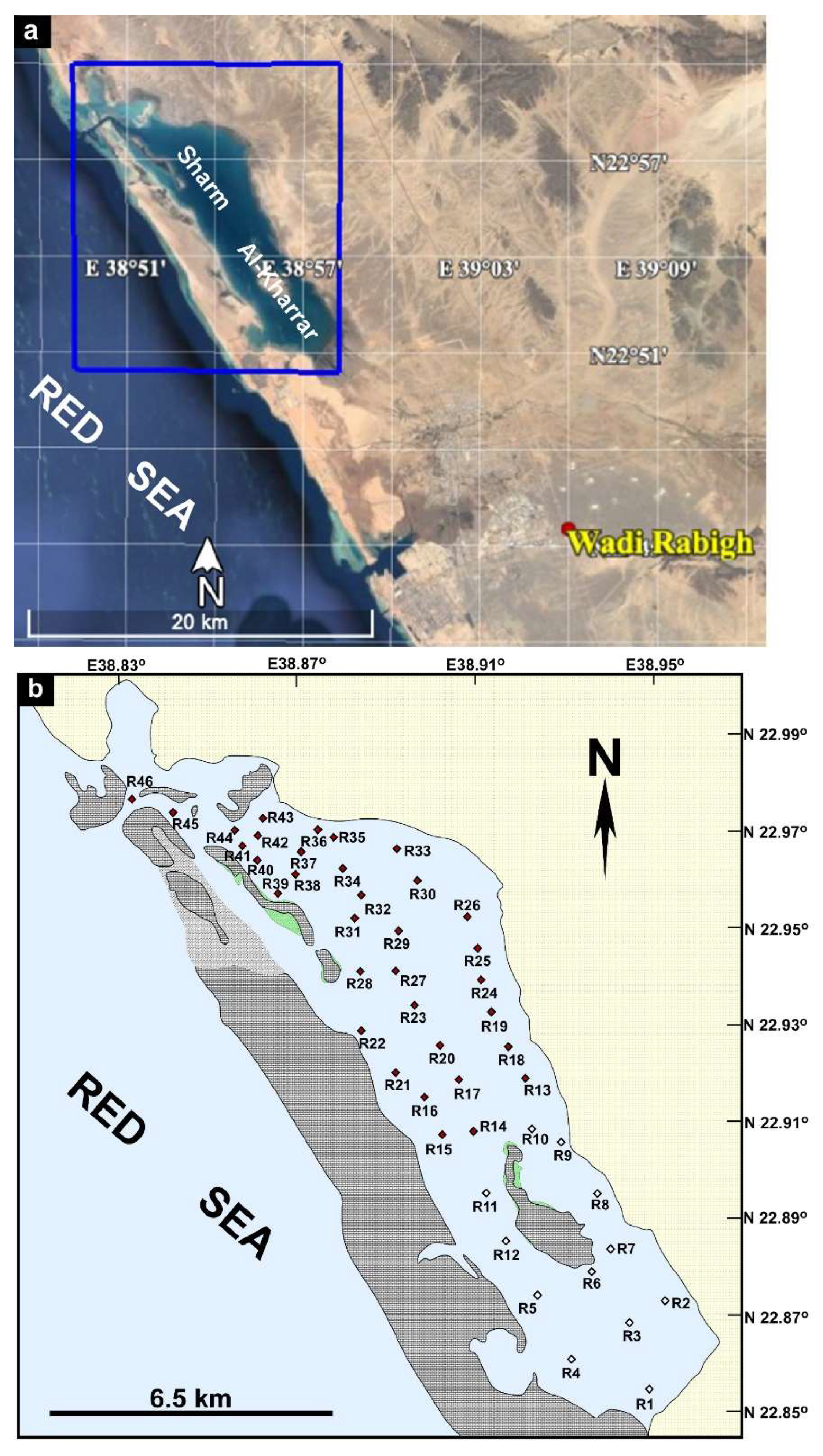
2. Area of Study
3. Materials and Methods
4. Results
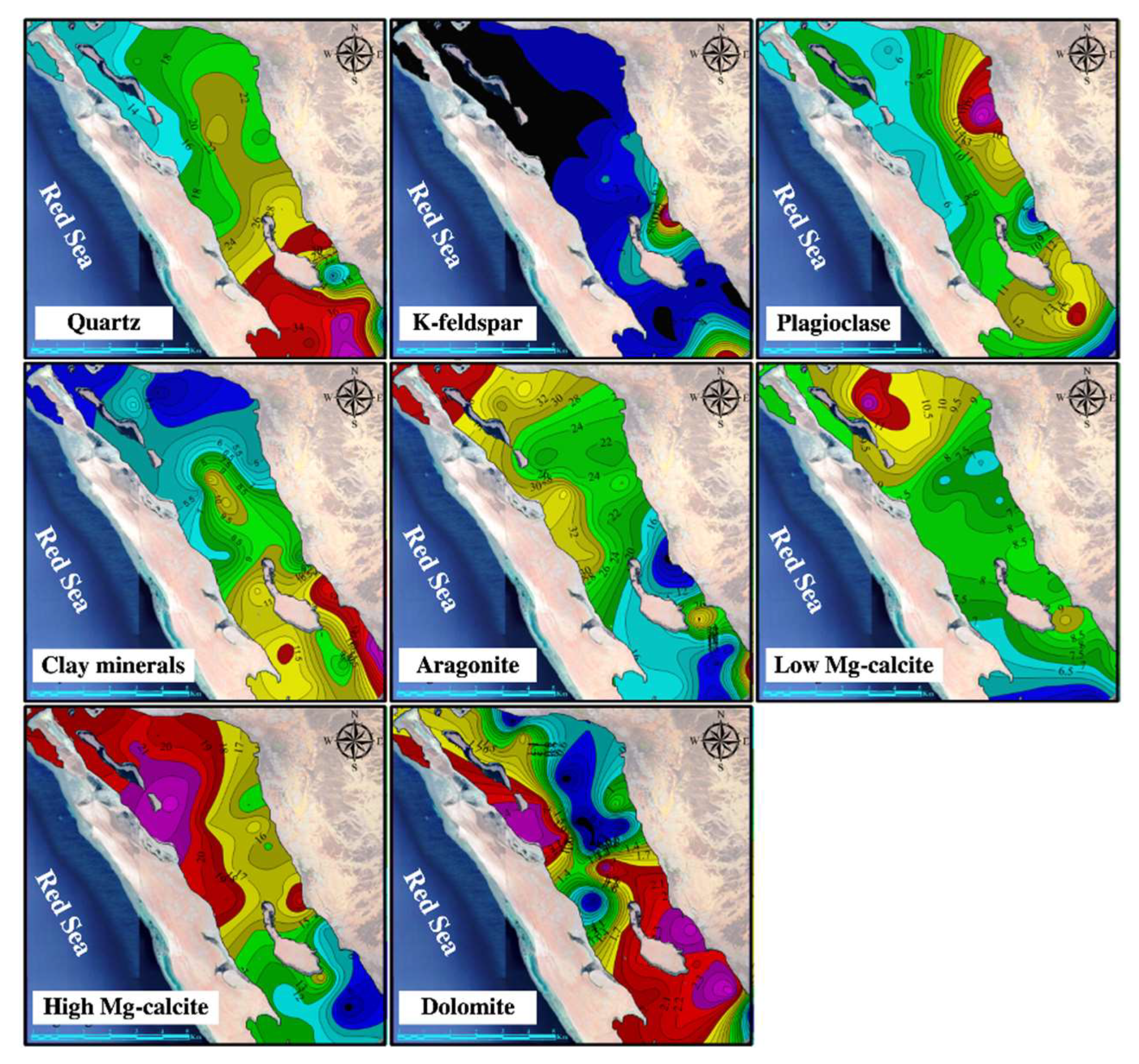
4.1. Mineralogical Composition
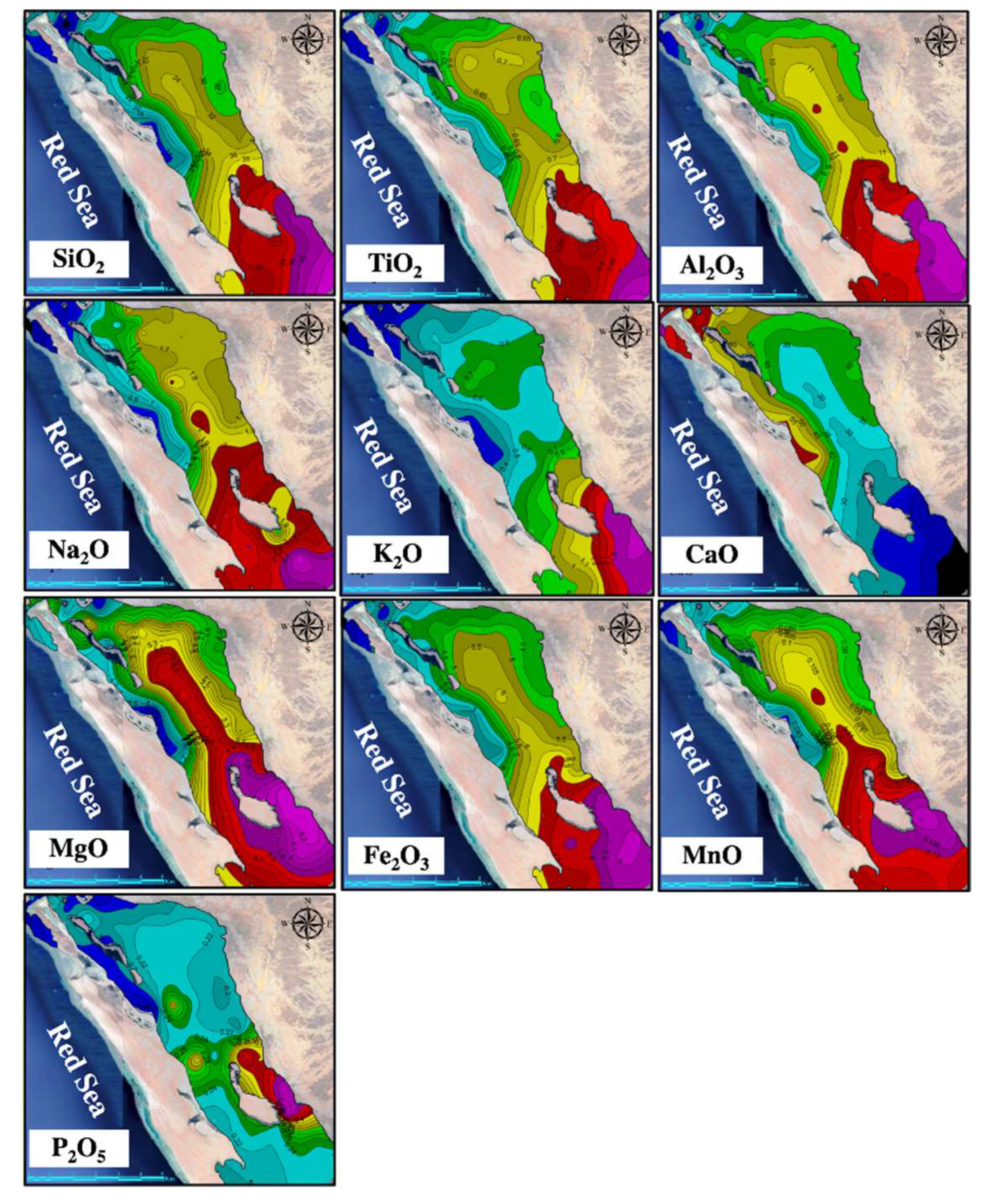
4.2. Oxides
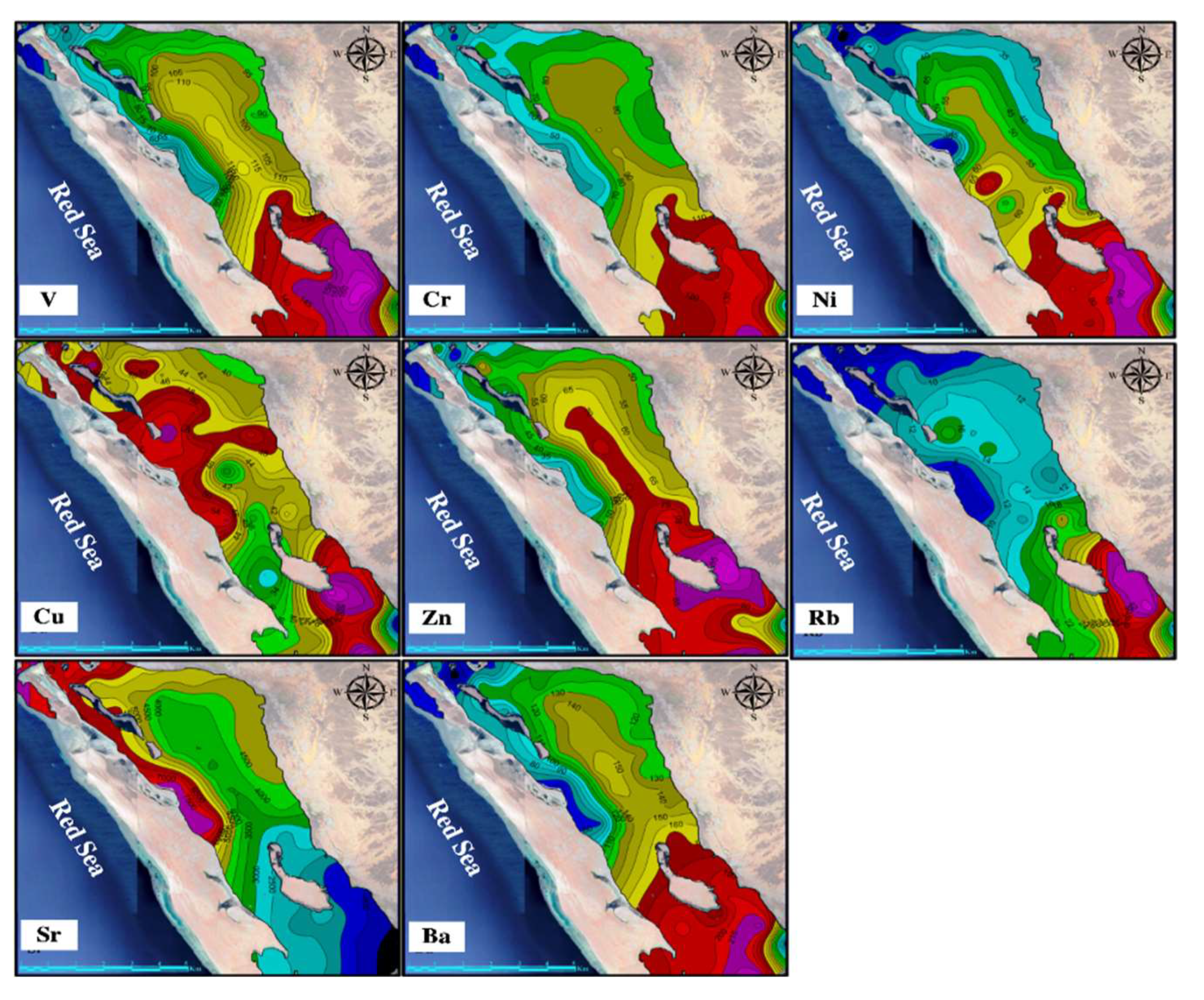
4.3. Minor and Trace Elements
4.4. Elemental Interrelationships
4.5. Enrichment Factor (EF)
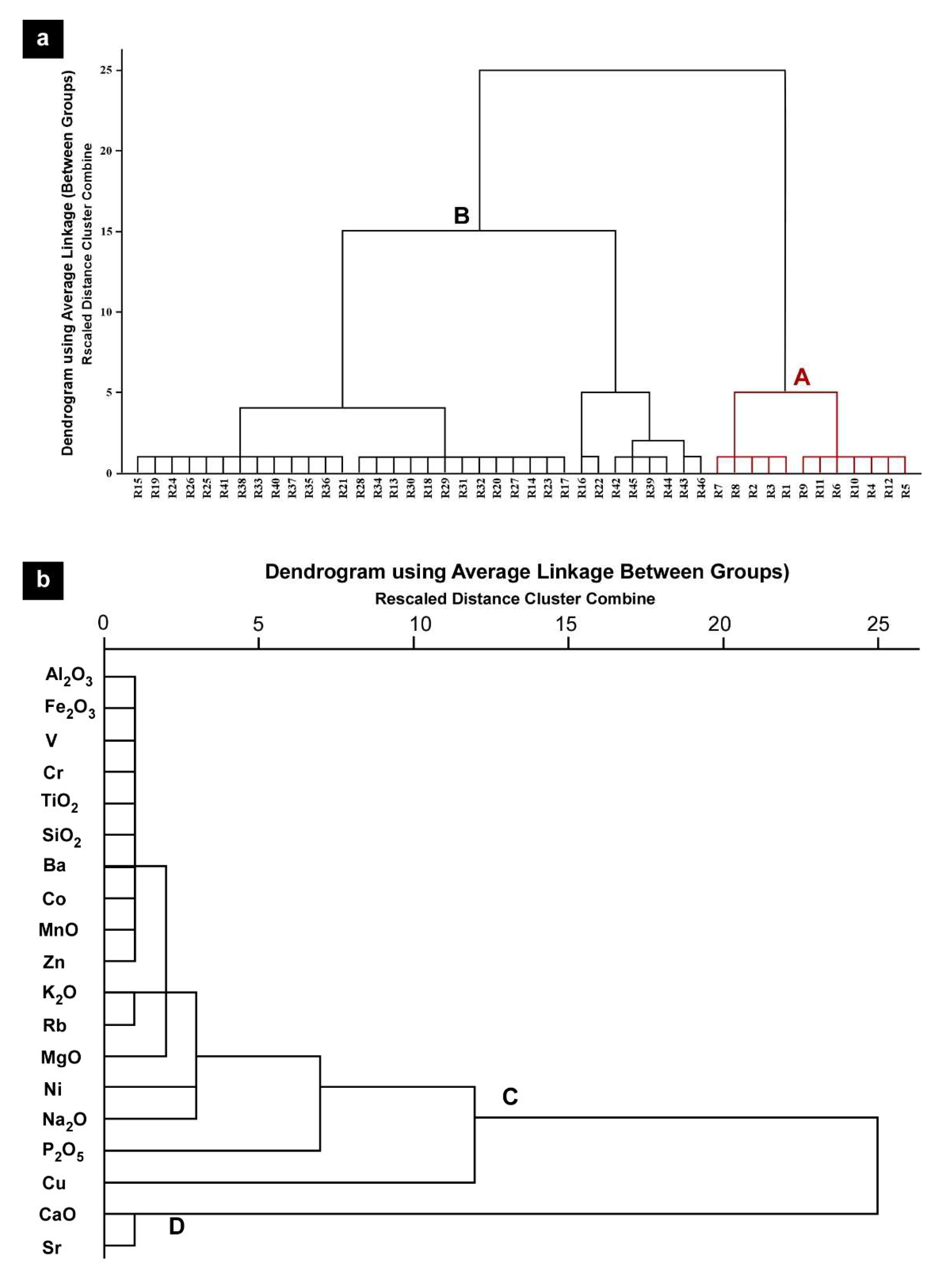
4.6. Statistical Analysis
5. Discussion
6. Conclusions
- The mineralogical and chemical composition of Al-Kharrar Lagoon bottom sediments reflects the interplay of terrestrial sediment influx through the temporarily active Wadi Rabigh, hydrological regime, and the autochthonous biogenic sedimentation, and to a lesser extent rare anthropogenic influence.
- Minerals of detrital origin (quartz, k-feldspars, plagioclase, and amphiboles) and highly enriched in the nearshore shallow areas of the southern sector of the lagoon at the mouth of Wadi Rabigh, whereas carbonate minerals (aragonite, high and low Mg-calcite) dominate the marine-influenced northern sector.
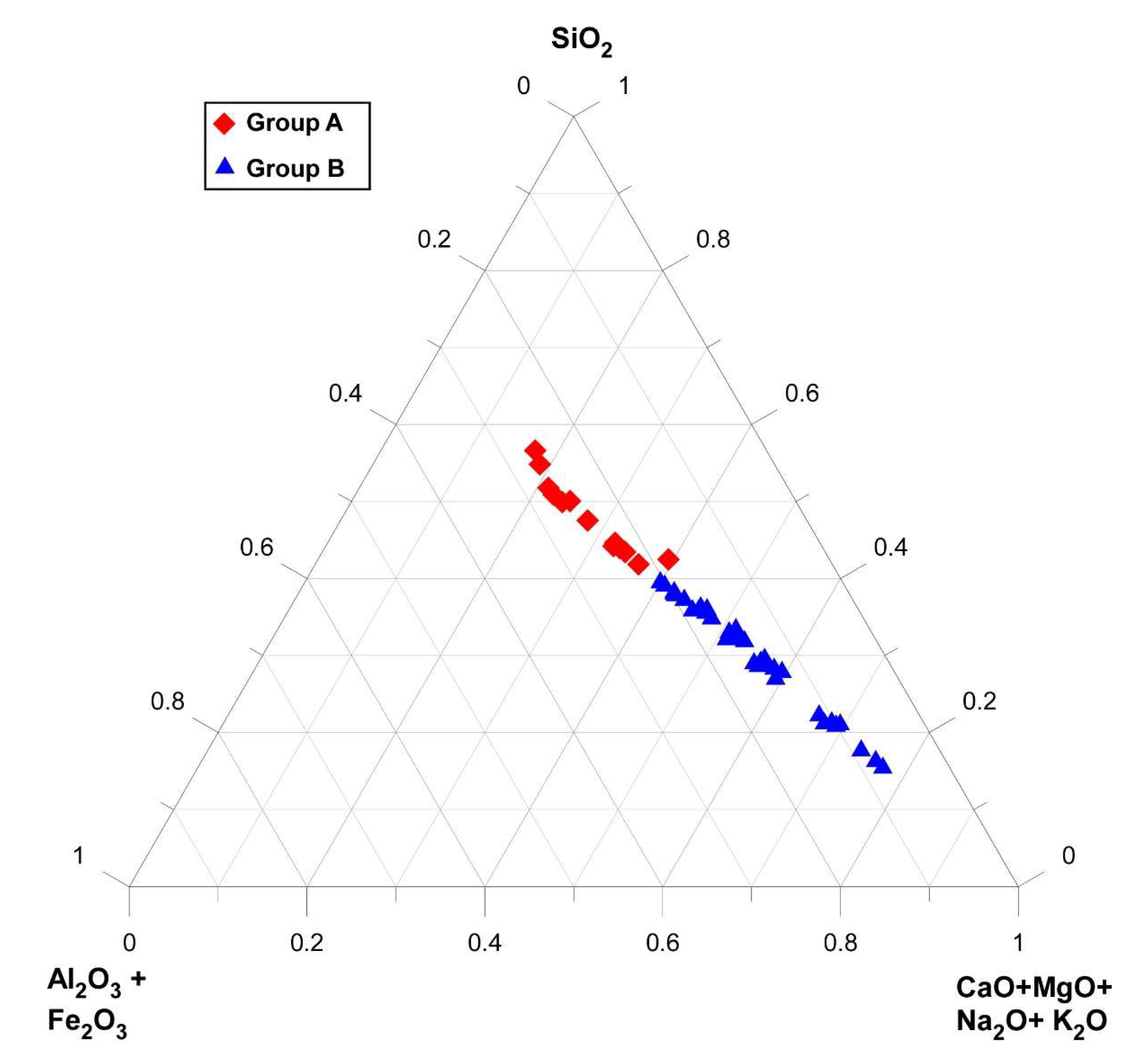
- Factor analysis distinguished two factors and allowed the subdivision of Al-Kharrar Lagoon bottom sediments geochemically into three geochemical groups. The first factor is characterized by positive loadings of lithogenic elements and negative values of variables linked to carbonate minerals. This factor records high concentrations of siliciclastic-related oxides and trace elements as well as high concentrations of carbonate-related elements. The second factor is characterized by positive loadings of Cu and P2O5 which have no relationship with the groups of the first factor. Statistical analysis has allowed the identification of two main groups of sediments.
- The lithogenic-related oxides (SiO2, TiO2, Al2O3, Fe2O3, MgO, Na2O, and K2O) and trace elements (V, Cr, Ni, Zn, Rb, and Ba) are enriched in the southern sector near the head of the lagoon. The spatial distribution patterns reveal that lithogenous sediments settled rapidly mostly near the Wadi mouth, and the sediments are restricted to the shallow area and not transported far into the deeper parts of the lagoon due to the low flow conditions.
- The carbonate-related oxides (CaO) and trace element (Sr) are significantly enriched in the northern sector where autochthonous shell fragments are the main source of carbonates.
- The levels of heavy metals are generally below the recommended allowable limits and the lagoon is in good ecological condition. The EF values of Cu show a local slight enrichment supporting a possible anthropogenic source. However, there has currently no clear evidence of heavy metal contamination by anthropogenic sources in the Al-Kharrar Lagoon.
- The obtained data are of particular significance providing a base to monitor any future environmental deterioration associated with development and urbanization.
Author Contributions
Funding
Data Availability Statement
Acknowledgments
Conflicts of Interest
References
- Morton, R.A.; Ward, G.H.; White, W.A. Rates of sediment supply and sea-level rise in a large coastal lagoon. Mar. Geol. 2000, 167, 261–284. [Google Scholar] [CrossRef]
- Forrest, B.M.; Creese, R.G. Benthic impacts of intertidal oyster culture, with consideration of taxonomic sufficiency. Environ. Monit. Assess. 2006, 112, 159–176. [Google Scholar] [CrossRef]
- Abidi, M.; Amor, R.; Gueddari, M. Assessment of the Trophic Status of the South Lagoon of Tunis (Tunisia, Mediterranean Sea): Geochemical and Statistical Approaches. J. Chem. 2018, 2018, 1–17. [Google Scholar] [CrossRef]
- Benoit, J.M.; Gilmour, C.C.; Mason, R.P.; Heyes, A. Sulfide controls on mercury speciation and bioavailability to methylating bacteria in sediment pore waters. Environ. Sci. Techol. 1999, 33, 1780. [Google Scholar] [CrossRef]
- Pérez-Ruzafa, A.; Marcos, C.; Pérez-Ruzafa, I.M.; Pérez-Marcos, M. Are coastal lagoons physically or biologically controlled ecosystems? Revisiting r vs. K strategies in coastal lagoons and estuaries. Estua. Coast. Shelf Sci. 2013, 132, 17–33. [Google Scholar] [CrossRef]
- Arcega-Cabrera, F.; Garza-Pérez, R.; Noreña-Barroso, E.; Oceguera-Vargas, I. Impacts of geochemical and environmental factors on seasonal variation of heavy metals in a coastal lagoon Yucatan, Mexico. Bull. Environ. Contam. Toxico. 2015, 94, 58–65. [Google Scholar] [CrossRef]
- Förstner, U.; Ahlf, W.; Calmano, W. Studies on the transfer of heavy metals between sedimentary phases with a multi-chamber device: Combined effects of salinity and redox variation. Mar. Chem. 1989, 28, 145–158. [Google Scholar] [CrossRef]
- Yu, K.C.; Tsai, L.J.; Chen, S.H.; Ho, S.T. Correlation analyses on binding behavior of heavy metals with sediment matrices. Water Res. 2001, 35, 2417–2428. [Google Scholar] [CrossRef]
- Karageorgis, A.P.; Anagnostou, C.L.; Kaberi, H. Geochemistry and mineralogy of the NW Aegean Sea surface sediments: Implications for river runoff and anthropogenic impact. Appl. Geochem. 2005, 20, 69–88. [Google Scholar] [CrossRef]
- Ahmed, F.; Bibi, M.H.; Seto, K.; Ishiga, H.; Fukushima, T.; Roser, B.P. Abundances, distribution, and sources of trace metals in Nakaumi–Honjo coastal lagoon sediments, Japan. Environ. Monit. Assess. 2010, 167, 473–491. [Google Scholar] [CrossRef]
- Rasul, N.M. Lagoon sediments of the Eastern Red Sea: Distribution processes, pathways and patterns. In The Red Sea; Springer: Berlin/Heidelberg, Germany, 2015; pp. 281–316. [Google Scholar]
- Basaham, A.S.; Ghandour, I.M.; Haredy, R. Controlling factors on the geochemistry of Al-Shuaiba and Al-Mejarma coastal lagoons, Red Sea, Saudi Arabia. Open Geosci. 2019, 11, 426–439. [Google Scholar] [CrossRef]
- Basaham, A.S. Mineralogical and chemical composition of the mud fraction from the surface sediments of Al-Kharrar, a Red Sea coastal lagoon. Oceanologia 2008, 50, 557–575. [Google Scholar]
- Abu-Zied, R.H.; Al-Mur, B.A.; Orif, M.I.; Al Otaibi, A.; Ghandourah, M.A. Concentration distribution, enrichment and controlling factors of metals in Al-Shuaiba Lagoon sediments, Eastern Red Sea, Saudi Arabia. Environ. Earth Sci. 2021, 80, 1–20. [Google Scholar] [CrossRef]
- Basaham, A.S.; El Sayed, M.A.; Ghandour, I.M.; Masuda, H. Geochemical background for the Saudi Red Sea coastal systems and its implication for future environmental monitoring and assessment. Environ. Earth Sci. 2015, 74, 4561–4570. [Google Scholar] [CrossRef]
- Ghandour, I.M.; Basaham, S.; Al-Washmi, A.; Masuda, H. Natural and anthropogenic controls on sediment composition of an arid coastal environment: Sharm Obhur, Red Sea, Saudi Arabia. Environ. Monit. Assess. 2014, 3, 1465–1484. [Google Scholar] [CrossRef]
- Youssef, M.; El-Sorogy, A. Environmental assessment of heavy metal contamination in bottom sediments of Al-Kharrar lagoon, Rabigh, Red Sea, Saudi Arabia. Arab. J. Geosci. 2016, 9, 474. [Google Scholar] [CrossRef]
- Ghandour, I.M.; Aljahdali, M.H. Elemental Enrichment in Shallow Subsurface Red Sea Coastal Sediments, Al-Shuaiba, Saudi Arabia: Natural vs. anthropogenic Controls. Minerals 2021, 11, 898. [Google Scholar] [CrossRef]
- Abou-Ouf, M.A. Variation of benthic foraminiferal assemblages in different microenvironments along the shore zone north of the Rabigh Coast, eastern Red Sea, Saudi Arabia. Neues Jahrbuch für Geologie und Paläontologie-Monatshefte 1996, 9, 129–139. [Google Scholar] [CrossRef]
- Al-Washmi, H.A. Sedimentological aspects and environmental conditions recognized from the bottom sediments of Al-Kharrar Lagoon, eastern Red Sea coastal plain, Saudi Arabia. J. King Abdulaziz Univ. Mar. Sci. 1999, 10, 71–87. [Google Scholar] [CrossRef]
- Hariri, M.S. Effect of hydrographic conditions on the ecology of benthic foraminifera in two different hypersaline lagoons, eastern Red Sea coast, Kingdom of Saudi Arabia. J. King Abdulaziz Univ. Mar. Sci. 2008, 19, 3–13. [Google Scholar] [CrossRef]
- Al-Barakati, A.M.A. Application of 2-D tidal model, Shuaiba Lagoon, eastern Red Sea coast. Can. J. Comput. Math. Nat. Sci. Med. 2010, 1, 9–20. [Google Scholar]
- Hariri, M.S.; Abu-Zied, R.H. Factors influencing heavy metal concentrations in the bottom sediments of the Al-Kharrar Lagoon and Salman Bay, eastern Red Sea coast, Saudi Arabia. Arab. J. Geosci. 2018, 11, 1–20. [Google Scholar] [CrossRef]
- Al-Dubai, T.A.; Bantan, R.A.; Abu-Zied, R.H.; Al-Zubieri, A.G.; Jones, B.G. Distribution of Benthic Foraminifera in Intertidal Sabkha of Al-Kharrar Lagoon, Saudi Arabia: Tools to Study Past Sea-Level Changes. Front. Mar. Sci. 2022, 351. [Google Scholar] [CrossRef]
- Al-Barakati, A.M.; Ahmad, F. Water column conditions in a coastal lagoon near Jeddah, Red Sea. Oceanologia 2012, 54, 675–685. [Google Scholar] [CrossRef]
- Lisitzin, E. Sea-Level Changes; Elsevier Sci. Publ. Co.: Amsterdam, The Netherlands; Oxford, UK; New York, NY, USA, 1974. [Google Scholar]
- Al-Dubai, T.A.; Abu-Zied, R.H.; Basaham, A.S. Present environmental status of Al-Kharrar Lagoon, central of the eastern Red Sea coast, Saudi Arabia. Arab. J. Geosci. 2017, 10, 305. [Google Scholar] [CrossRef]
- Hardy, R.; Tucker, M.E. Techniques in Sedimentology; Blackwell Scientific Publications: Hoboken, NJ, USA, 1988; pp. 191–228. [Google Scholar]
- Moore, D.M.; Reynolds, R.C., Jr. X-ray Diffraction and the Identification and Analysis of Clay Minerals; Oxford University Press: New York, NY, USA, 1989. [Google Scholar]
- Tawfik, H.A.; Ghandour, I.M.; Maejima, W.; Armstrong-Altrin, J.S.; Abdel-Hameed, A.M. Petrography and geochemistry of the siliciclastic Araba Formation (Cambrian), east Sinai, Egypt: Implications for provenance, tectonic setting and source weathering. Geol. Magaz. 2017, 154, 1–23. [Google Scholar] [CrossRef]
- Haredy, R.; Ghandour, I.M. Geochemistry and mineralogy of the shallow subsurface Red Sea coastal sediments, Rabigh, Saudi Arabia: Provenance and paleoenvironmental implications. Turk. J. Earth Sci. 2020, 29, 257–279. [Google Scholar] [CrossRef]
- Covelli, S.; Fontolan, G. Application of a normalization procedure in determining regional geochemical baseline. Environ. Geol. 1997, 30, 34–35. [Google Scholar] [CrossRef]
- Sutherland, R.A. Bed sediment-associated trace metals in an urban stream, Oahu, Hawaii. Environ. Geol. 2000, 39, 611–627. [Google Scholar] [CrossRef]
- Calvert, S.E. The mineralogy and geochemistry of nearshore sediments. In Chemical Oceanography; Riley, J.P., Chester, R., Eds.; Academic Press: London, UK, 1976; Volume 6, pp. 187–280. [Google Scholar]
- Loring, D.H.; Rantala, R.T. Manual for the geochemical analyses of marine sediments and suspended particulate matter. Earth-Sci. Rev. 1992, 32, 235–283. [Google Scholar] [CrossRef]
- Mil-Homens, M.; Vale, C.; Raimundo, J.; Pereira, P.; Brito, P.; Caetano, M. Major factors influencing the elemental composition of surface estuarine sediments: The case of 15 estuaries in Portugal. Mar. Poll. Bull. 2014, 84, 135–146. [Google Scholar] [CrossRef]
- Calvert, S.E.; Pedersen, T.F.; Thunell, R.C. Geochemistry of the surface sediments of the Sulu and South China Seas. Mar. Geol. 1993, 114, 207–231. [Google Scholar] [CrossRef]
- Taylor, G.; Eggleton, R.A. Regolith Geology and Geomorphology, 1st ed.; John Wiley and Sons: Hoboken, NJ, USA, 2001. [Google Scholar]
- Lejon, D.P.; Martins, J.M.; Lévêque, J.; Spadini, L.; Pascault, N.; Landry, D.; Milloux, M.J.; Nowak, V.; Chaussod, R.; Ranjard, L. Copper dynamics and impact on microbial communities in soils of variable organic status. Environ. Sci. Technol. 2008, 42, 2819–2825. [Google Scholar] [CrossRef]
- He, Z.L.; Yang, X.E.; Stoffella, P.J. Trace elements in agroecosystems and impacts on the environment. J. Trace Elements Medic. Biol. 2005, 19, 125–140. [Google Scholar] [CrossRef]
- Ruiz-Fernández, A.C.; Frignani, M.; Hillaire-Marcel, C.; Ghaleb, B.; Arvizu, M.D.; Raygoza-Viera, J.R.; Páez-Osuna, F. Trace metals (Cd, Cu, Hg, and Pb) accumulation recorded in the intertidal mudflat sediments of three coastal lagoons in the Gulf of California, Mexico. Estu.Coast. 2009, 32, 551–564. [Google Scholar] [CrossRef]
- Avramidis, P.; Barouchas, P.; Dünwald, T.; Unkel, I.; Panagiotaras, D. The influence of olive orchards copper-based fungicide use, in soils and sediments-The case of Aetoliko (Etoliko) Lagoon Western Greece. Geosciences 2019, 9, 267. [Google Scholar] [CrossRef]
- Adriano, D.C.; Wenzel, W.W.; Vangronsveld, J.; Bolan, N.S. Role of assisted natural remediation in environmental cleanup. Geoderma 2004, 122, 121–142. [Google Scholar] [CrossRef]
- Badassan, T.E.; Avumadi, A.M.; Ouro-Sama, K.; Gnandi, K.; Jean-Dupuy, S.; Probst, J.L. Geochemical Composition of the Lomé Lagoon Sediments, Togo: Seasonal and Spatial Variations of Major, Trace and Rare Earth Element Concentrations. Water 2020, 11, 3026. [Google Scholar] [CrossRef]
- Huo, S.; Xi, B.; Yu, X.; Su, J.; Zan, F.; Zhao, G. Application of equilibrium partitioning approach to drive sediment quality criteria for heavy metals in a shallow eutrophic lake, Lake Chaohu, China. Environ. Earth Sci. 2013, 69, 2275–2285. [Google Scholar] [CrossRef]
- Nizoli, E.C.; Luiz-Silva, W. Seasonal AVS–SEM relationship in sediments and potential bioavailability of metals in industrialized estuary, southeastern Brazil. Environ. Geochem. Health 2012, 34, 263–272. [Google Scholar] [CrossRef]
- Zhang, C.; Yu, Z.G.; Zeng, G.M.; Jiang, M.; Yang, Z.Z.; Cui, F.; Zhu, M.Y.; Shen, L.Q.; Hu, L. Effects of sediment geochemical properties on heavy metal bioavailability. Environ. Int. 2014, 73, 270–281. [Google Scholar] [CrossRef]
- Guigue, J.; Mathieu, O.; Lévêque, J.; Denimal, S.; Steinmann, M.; Milloux, M.J.; Grisey, H. Dynamics of copper and zinc sedimentation in a lagooning system receiving landfill leachate. Waste Manag. 2013, 33, 2287–2295. [Google Scholar] [CrossRef]
- Almahasheer, H.; Serrano, O.; Duarte, C.M.; Irigoien, X. Remobilization of heavy metals by mangrove leaves. Front. Mar. Sci. 2018, 13, 484. [Google Scholar] [CrossRef]


| Sample | Clay Minerals | Mica | Amphiboles | Quartz | K-Feldspars | Plagioclase | Aragonite | HMC | LMC | Dolom. |
|---|---|---|---|---|---|---|---|---|---|---|
| R1 | 10 | - | 7 | 44 | 20 | - | 4 | 4 | 11 | 2 |
| R2 | 18 | 4 | 3 | 38 | - | 13 | 6 | 7 | 7 | 3 |
| R3 | 9 | - | 5 | 42 | 5 | 18 | 6 | 7 | 5 | 2 |
| R4 | 13 | 3 | 3 | 32 | - | 11 | 18 | 6 | 12 | 2 |
| R5 | 12 | - | 4 | 36 | - | 13 | 14 | 7 | 11 | 2 |
| R6 | 9 | - | 4 | 31 | - | 10 | 18 | 9 | 17 | 2 |
| R8 | 14 | - | 4 | 35 | 4 | 13 | 10 | 8 | 10 | 3 |
| R9 | 7 | - | 9 | 29 | 23 | - | - | 9 | 21 | 2 |
| R10 | 11 | - | 3 | 31 | - | 11 | 17 | 9 | 17 | 2 |
| R11 | 12 | - | 3 | 29 | 3 | 11 | 18 | 8 | 15 | 2 |
| R12 | 11 | - | 5 | 33 | 4 | 10 | 14 | 7 | 13 | 2 |
| R15 | 7 | 2 | 2 | 20 | - | 6 | 33 | 8 | 20 | - |
| R17 | 10 | - | 2 | 23 | 4 | 9 | 23 | 10 | 16 | 3 |
| R18 | 8 | - | 5 | 21 | 3 | 15 | 23 | 8 | 15 | 1 |
| R19 | 6 | - | 2 | 19 | 3 | 13 | 30 | 8 | 19 | - |
| R20 | 11 | - | 1 | 23 | - | 9 | 28 | 9 | 18 | - |
| R22 | 5 | - | 2 | 16 | - | 5 | 38 | 9 | 22 | 2 |
| R23 | 12 | - | 3 | 26 | - | 9 | 25 | 9 | 17 | - |
| R24 | 5 | - | 5 | 22 | - | 24 | 22 | 7 | 14 | 1 |
| R28 | 5 | - | 2 | 15 | - | 7 | 26 | 15 | 28 | 2 |
| R29 | 5 | 3 | 3 | 23 | - | 8 | 25 | 11 | 22 | - |
| R35 | 2 | - | 2 | 17 | - | 5 | 39 | 14 | 20 | 2 |
| R36 | 10 | 3 | - | 17 | - | 7 | 34 | 12 | 21 | - |
| R38 | 7 | - | - | 19 | - | 6 | 29 | 15 | 23 | 1 |
| R39 | 5 | - | 2 | 14 | - | 9 | 37 | 11 | 20 | 2 |
| R43 | 4 | - | 3 | 12 | - | 7 | 44 | 11 | 19 | 1 |
| Oxides/elements | Minimum | Maximum | Mean |
|---|---|---|---|
| SiO2 | 12.85 | 51.62 | 31.25 |
| TiO2 | 0.26 | 1.12 | 0.62 |
| Al2O3 | 4.23 | 16.33 | 10.32 |
| T-Fe2O3 | 2.06 | 9.12 | 5.35 |
| MnO | 0.04 | 0.15 | 0.09 |
| MgO | 3.39 | 6.26 | 5.16 |
| CaO | 8.12 | 61.27 | 35.20 |
| Na2O | 0.69 | 2.8 | 1.65 |
| K2O | 0.22 | 1.62 | 0.67 |
| P2O5 | 0.13 | 0.51 | 0.24 |
| V | 48 | 168 | 104.74 |
| Cr | 34 | 155 | 82.26 |
| Ni | 14 | 93 | 51.24 |
| Cu | 30 | 64 | 47.72 |
| Zn | 25 | 99 | 61.57 |
| Rb | 3 | 45 | 15.50 |
| Sr | 624 | 7932 | 4155 |
| Ba | 46 | 232 | 134 |
| Mg/Ca | 0.05 | 0.59 | 0.17 |
| Sr/Ca | 107 | 185 | 160 |
| EFV | 0.55 | 0.68 | 0.61 |
| EFCr | 0.65 | 0.91 | 0.73 |
| EFCu | 0.64 | 3.63 | 1.52 |
| EFZn | 0.88 | 1.77 | 1.42 |
| Oxides/Elements | SiO2 | TiO2 | Al2O3 | T-Fe2O3 | MnO | MgO | CaO | Na2O | K2O | P2O5 | V | Cr | Ni | Cu | Zn | Rb | Sr | Ba |
|---|---|---|---|---|---|---|---|---|---|---|---|---|---|---|---|---|---|---|
| SiO2 | 1 | |||||||||||||||||
| TiO2 | 0.99 | 1 | ||||||||||||||||
| Al2O3 | 0.99 | 0.97 | 1 | |||||||||||||||
| T-Fe2O3 | 0.98 | 0.97 | 0.99 | 1 | ||||||||||||||
| MnO | 0.95 | 0.93 | 0.98 | 0.97 | 1 | |||||||||||||
| MgO | 0.89 | 0.86 | 0.93 | 0.90 | 0.92 | 1 | ||||||||||||
| CaO | −0.99 | −0.98 | −0.99 | −0.99 | −0.96 | −0.91 | 1 | |||||||||||
| Na2O | 0.88 | 0.87 | 0.86 | 0.83 | 0.82 | 0.75 | −0.88 | 1 | ||||||||||
| K2O | 0.92 | 0.93 | 0.91 | 0.93 | 0.84 | 0.76 | −0.92 | 0.73 | 1 | |||||||||
| P2O5 | 0.50 | 0.48 | 0.50 | 0.50 | 0.47 | 0.54 | −0.47 | 0.29 | 0.53 | 1 | ||||||||
| V | 0.98 | 0.97 | 0.99 | 0.99 | 0.97 | 0.90 | −0.99 | 0.85 | 0.92 | 0.48 | 1 | |||||||
| Cr | 0.98 | 0.98 | 0.98 | 0.99 | 0.95 | 0.87 | −0.98 | 0.84 | 0.93 | 0.49 | 0.98 | 1 | ||||||
| Ni | 0.84 | 0.83 | 0.87 | 0.88 | 0.83 | 0.78 | −0.84 | 0.69 | 0.84 | 0.50 | 0.87 | 0.88 | 1 | |||||
| Cu | 0.07 | 0.08 | 0.09 | 0.12 | 0.03 | 0.07 | −0.07 | −0.29 | 0.26 | 0.23 | 0.09 | 0.13 | 0.20 | 1 | ||||
| Zn | 0.93 | 0.91 | 0.95 | 0.94 | 0.95 | 0.92 | −0.93 | 0.74 | 0.81 | 0.54 | 0.93 | 0.92 | 0.82 | 0.02 | 1 | |||
| Rb | 0.89 | 0.89 | 0.89 | 0.91 | 0.82 | 0.75 | −0.88 | 0.64 | 0.98 | 0.56 | 0.90 | 0.91 | 0.84 | 0.35 | 0.82 | 1 | ||
| Sr | −0.99 | −0.98 | −0.99 | −0.98 | −0.96 | −0.92 | 0.99 | −0.87 | −0.91 | −0.48 | −0.98 | −0.98 | −0.83 | −0.06 | −0.94 | −0.88 | 1 | |
| Ba | 0.99 | 0.97 | 0.98 | 0.97 | 0.94 | 0.88 | −0.99 | 0.90 | 0.90 | 0.44 | 0.97 | 0.97 | 0.83 | 0.05 | 0.91 | 0.86 | −0.98 | 1 |
| Variable | F1 | F2 |
|---|---|---|
| SiO2 | 0.99 | −0.055 |
| TiO2 | 0.98 | −0.038 |
| Al2O3 | 0.99 | −0.032 |
| Fe2O3 | 0.99 | 0.003 |
| MnO | 0.97 | −0.087 |
| MgO | 0.91 | −0.029 |
| CaO | -0.99 | 0.062 |
| Na2O | 0.85 | −0.438 |
| K2O | 0.93 | 0.195 |
| P2O5 | 0.53 | 0.414 |
| V | 0.99 | −0.027 |
| Cr | 0.99 | 0.007 |
| Ni | 0.88 | 0.138 |
| Cu | 0.11 | 0.925 |
| Zn | 0.94 | 0.002 |
| Rb | 0.91 | 0.3 |
| Sr | −0.99 | 0.068 |
| Ba | 0.98 | −0.10 |
| Eigen value | 17.18 | 1.4 |
| % of variance | 84.85 | 6.67 |
Publisher’s Note: MDPI stays neutral with regard to jurisdictional claims in published maps and institutional affiliations. |
© 2022 by the authors. Licensee MDPI, Basel, Switzerland. This article is an open access article distributed under the terms and conditions of the Creative Commons Attribution (CC BY) license (https://creativecommons.org/licenses/by/4.0/).
Share and Cite
Ghandour, I.M.; Mannaa, A.; Alharbi, O.; Masoud, A.A.; Aljahdali, M.H. Major Factors Controlling the Elemental Composition of Al-Kharrar Lagoon Bottom Sediments, Rabigh, Saudi Arabia. Minerals 2022, 12, 1096. https://doi.org/10.3390/min12091096
Ghandour IM, Mannaa A, Alharbi O, Masoud AA, Aljahdali MH. Major Factors Controlling the Elemental Composition of Al-Kharrar Lagoon Bottom Sediments, Rabigh, Saudi Arabia. Minerals. 2022; 12(9):1096. https://doi.org/10.3390/min12091096
Chicago/Turabian StyleGhandour, Ibrahim M., Ammar Mannaa, Omar Alharbi, Alaa A. Masoud, and Mohammed H. Aljahdali. 2022. "Major Factors Controlling the Elemental Composition of Al-Kharrar Lagoon Bottom Sediments, Rabigh, Saudi Arabia" Minerals 12, no. 9: 1096. https://doi.org/10.3390/min12091096