
Geochemical Indication of Functional Zones at the Archaeological Sites of Eastern Europe


Department of Geology and Geoecology, Herzen State Pedagogical University, 191186 St. Petersburg, Russia
Minerals 2022, 12(9), 1075; https://doi.org/10.3390/min12091075
Submission received: 1 July 2022
/
Revised: 29 July 2022
/
Accepted: 23 August 2022
/
Published: 25 August 2022
(This article belongs to the Special Issue Environment and Geochemistry of Sediments)
Abstract
:The article considers a new approach for determining the functional zones of the prehistoric archaeological sites in Eastern Europe by the method of geochemical indication: the use of mathematical statistics for processing the geochemical data of cultural deposits at archaeological sites, and the identification of groups of interrelated chemical elements and compounds that reflects the processes of natural sedimentation and anthropogenic activity. It makes it possible to separate the lithological and anthropogenic components. This approach is important for the identification of geochemical element groups associated with different functional zones. The reconstructions were conducted at the Neolithic, Early Metal Age, and the Bronze-Early Iron Age sites in Eastern Europe. Abnormal concentrations of the association (P2O5antr, CaOantr and Srantr) in sediments are attributed to zones of accumulation of bone remains. Anomalous concentrations of a group of elements (K2Oantr, Rbantr) in deposits are associated with wood ash and fireplaces, ash residues from ritual activities, and fires. The group of elements (Ba, MnO, Corg) reflects the accumulation of humus and organic remains, and can characterize areas with food residues, skins, and rotten wood. With the help of the distribution of the main lithological elements (SiO2, Al2O3) in sediments, it is possible to reconstruct the paleorelief at the sites.
1. Introduction
The problem of the functional zone determinations on archaeological sites is very important for an understanding of the spatial distribution of different structures connected with ancient human activity. The living and household buildings had not been preserved on most sites of the Stone, Bronze, and Iron Ages and their space reconstructions are impossible through the archaeological methods only. The activities of prehistoric people influenced the variations in the chemical compositions of the soil by enriching it with or depleting it of certain chemical elements that form archaeological soils and cultural layers [1]. The geochemical markers of anthropogenic activity are conserved in the deposits for many years. In this connection, the application of the geochemical methods at the archaeological sites is a useful instrument for the analysis of cultural layers and determination of the ancient anthropogenic activity at the sites and the reconstruction of functional zones. The last time, the method of geochemical indication for the functional zone is actively being developed in different archaeological sites in Eastern Europe.
The spatial distribution of anomalous concentrations of some chemical elements in the places of ancient settlements makes it possible to establish the boundaries of archaeological sites and their locations; obtain information about the landscape features; establish functional zones and features of various structures within the settlements [2,3]. As a rule, elements for determining anthropogenic activity on ancient sites are P, Ca, K, Na, and Mg, as are the trace elements Cd, Cr, Cu, Pb, and Zn [4,5,6,7,8,9,10]. Aston et al. [4] identified the main functions of human activity in which the accumulation of anthropogenic chemical elements occurs: the development of ancient settlements, animal breeding in close quarters, the use of fire (fireplaces, slash-and-burn cultivation), ancient metallurgy, or subsistence activities (production of leather, processing of crops). One of the important anthropogenic indicators is phosphorus. Phosphorus is the main component of human and animal bones, a component of living tissues (in the form of nucleic acids, phospholipids, nucleotides, and so on), and a component of everyday products (such as wood, plant, or meat products) [11]. Phosphorus can accumulate in the soils of ancient settlements as a result of food preparation and the utilization of waste products [8]. The concentration of organic materials containing phosphorus, accumulated in the process of human activity, is proportional to the time of human occupation and the growth of the population [12]. Therefore, the phosphorus content in cultural layers is an indicator of the intensity of human occupation in the area. The phosphorus concentration in the soil increases depending on the supply of different organic materials, such as plants and animals, that are used by people. The decomposition of animal and plant organisms in settlement areas, the use of animal dung as fertilizer, and the physiological activity of humans and animals in their habitation areas increase phosphorus concentration in soils [7]. The different phosphorus compounds in soils are stable to oxidation, reduction, leaching, and dissolution [13,14] and newly mineralized inorganic phosphorus, while generally retained in the soil, is subject to some vertical translocation in the soil due to factors directly affecting adsorption, such as pH, cation exchange capacity, and cation availability [15,16]. The distribution of inorganic phosphate is therefore determined by the chemistry and adsorption kinetics of the soil throughout decomposition and precipitation [7].
At archaeological sites, cultural deposits usually consist of household waste, bones, metal slag, ashes, dung, and the remains of burials and cremations, etc. Application of other geochemical elements and indicators derives additional information about site occupation. Such elements as potassium (K) and sodium (Na) can be connected with the presence of fire ash in the areas of fireplaces [17]. However, it needs to be noted that these elements are the main components of feldspar and plagioclase minerals from lithological sediments. Rubidium (Rb) could be taken up by plants as a substitute for potassium (K), which it chemically resembles. These elements can be considered as anthropogenic components at the archaeological site just in comparison with the background or a correlation between high concentrations and any evidence of charcoal or fire ashes at the ancient places.
According to Wells et al. [10], the complex of elements (Fe, Mn, Zn, and Cu) can indicate areas of waste disposal, burials, cesspools, or rubbish after feasts. Increased concentrations of iron (Fe) and mercury (Hg) at settlements can be explained by the use of different natural pigments in rituals. It should also be noted that the accumulation of geochemical components depends also on the different natural factors of sedimentation such as geomorphology, diagenetic transformations of sediments, climatic conditions, and others. For example, if the archaeological sites are located in areas with complex relief, the primary distribution of chemical elements may have changed as a result of erosion after the elements were originally deposited in the soil. The destroyed material accumulates in depressions and at the feet of slopes as colluvium [1]. These cases require the development of a uniform methodological approach, the determination of a precise geochemical background, and the understanding of geochemical processes at the site. Application of indicator ratios of chemical elements reflects the degree of enrichment of anthropogenic elements in comparison with their background concentrations in the soils of the settlement and outside of it [1,18]. The method of “multi-element” analysis [3,8,13], which has been applied relatively recently, allows us to establish a complex of several chemical components and to consider their connection with different functional zones. Scholars established some groups of the chemical elements characterizing certain functional zones connected with anthropogenic activity [1]: abnormal concentrations of P (phosphorous), Cu (copper), Mn (manganese), Ca (calcium) connect with burials/cemeteries [19,20,21]; zones of fireplaces–P, K, Mg (magnesium), Zn (zinc), Rb [22,23]; waste piles-P, K [10,24,25]; farm areas, inner space of living buildings-P (phosphorus), Ca, Mg, Fe, K, Th (thorium), Rb, Cs (cesium), Pb (lead), Zn (zinc), Sr (strontium), Ba (barium) [3,10,24,25,26,27,28,29]; paints–the heavy metals [10]; ore mines, metallurgy-Cu (copper), Pb (lead), Mn (manganese) [30,31,32,33,34]; places of archaeological sites-B (boron), Cu (copper), Mg, Mn, Ni (nickel), P, Se (selenium), Zn (zinc), K (potassium), Ba (barium), Ca (calcium), and Na (sodium) [13,19,21,34].
2. Materials and Methods
The samples of cultural deposits were collected at sites of different ages (Figure 1). The main characteristics of sites are presented in Table 1. The sediment samples were taken at intervals of 0.6 m on the coordinate grid on the surface of cultural layer at each archaeological site under consideration. The coordinates of the primary point of sampling were registered by GPS.
The Serteya archaeological microregion (Figure 1) is located in the basin of the Dvina-Lovat’ basin, in the southern part of the Pskov and northwestern parts of the Smolensk region. Ancient lakes in the area of the Serteya archaeological microregion were formed after the retreat of the glacier and were located in a chain, separated by narrow isthmuses, which were eroded during periods of rising water levels. Along their shores, as well as in the central parts of the lake basins, there are unique archaeological sites that were dated from the 8th millennium BC up to 10 c. AD. At present, the lake basins are swamped and inherited by the narrow channel of the Serteya River, which flows into the Western Dvina River. The archaeological excavations are conducted by the northwestern expedition of the State Hermitage Museum (St.Petersburg, the head of the expedition is A. Mazurkevich) [36,37]. Thirty-five samples from the 1st cultural layer, three control samples beyond the archaeological area and 28 samples from the 2nd cultural layer, and three control samples were taken for analysis at the Serteya 3-3 site.
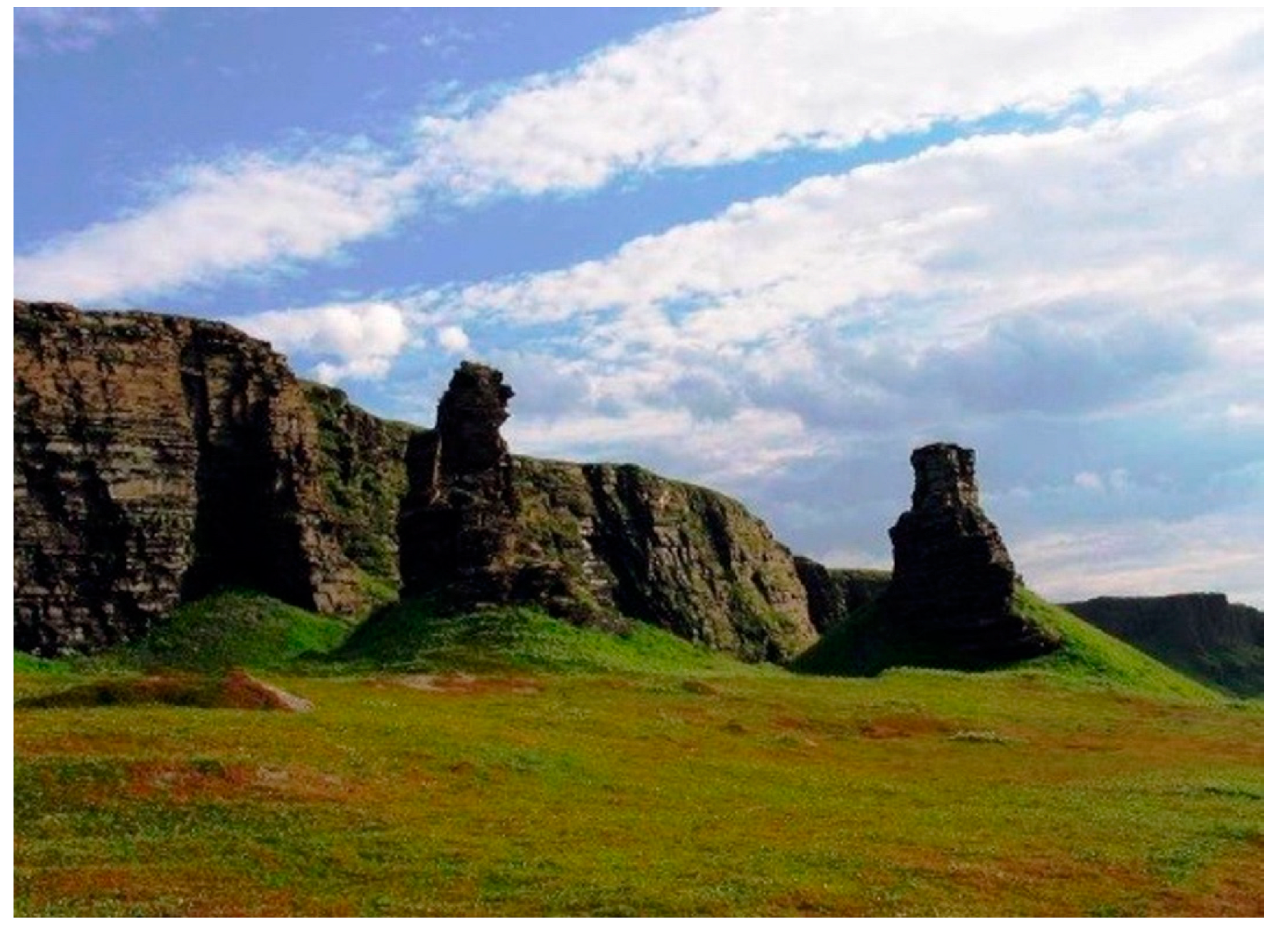
Rocky remains “Bratja”—an object of the post-glacial geological history of Fennoscandia, located directly on the seashore, in the northwestern part of the Sredny Peninsula (Figure 1 and Figure 2). Two picturesque stone pillars of a bizarre shape stand out in the surrounding landscape, which is similar to natural “statues” with a mythological meaning [39]. The pillars are located on a flat, first sea terrace-an ancient pebble beach, at an altitude of about 15 m above sea level. Sediments of medium grain size sand were sampled under the turf layer for determination of cultural layer features. Forty samples from the cultural layer at the Bratja object and eight control (background) samples were taken outside of the place. The investigations were provided together by the archaeologist M. Shakhnovich (National Museum Republic of Karelia, Petrozavodsk, Russia).
Sites of the Neolithic-Early Metal Age (Okhta 1 and Podolye 1) are located in the Ladoga Lake basin (Figure 1). The excavations were conducted under the head of T. Gusentsova and P. Sorokin (Institute of the Cultural Heritage, St. Petersburg, Russia). The Okhta 1 site is located on the border of the Russian Platform and the Baltic-Scandinavian crystalline shield, on a sandy cape formed after the Littorina transgression [18,36,40,41]. On the Okhtinsky Cape, at the confluence of the Okhta and Neva rivers, a unique multi-layered monument was discovered containing cultural layers of the Neolithic and Early Metal Ages, the Early Iron Age, and Roman times. The site Podolye 1 is located on the southern coast of Lake Ladoga, about 4 km from the coast [41,42]. At the Podolye 1 site, as well as at Okhta 1, wooden fishing structures of different ages were found. The lower cultural layer is light yellow silt with thin interlayers of peat. The upper cultural horizon consists of sandy-silty sediments with thin black organic layers. Dense grey loam overlaps these layers. Twenty-five samples from the cultural layer at the Okhta 1 site, three control samples and 32 samples from the upper cultural layer at the Podolye 1 site and five control samples were sampled.
At the Tarkhankut-18 site (Figure 1), located on the Tarkhankut Peninsula in Crimea, there are the Late Bronze-Early Iron Age complexes. The excavations were provided by M.T. Kashuba (IIMC RSA, St. Petersburg, Russia) and T.N. Smekalova (Crimea Federal University, Simferopol, Autonomous Republic of Crimea) [43]. The cultural layer has been formed on the surface of the aeolian deposits. The samples have been taken from the surface of the cultural layer and from the aeolian deposits (background pit) to establish the background contents of geochemical components. The background pit was laid outside the archaeological site for determination of the composition of geologically similar deposits that are not subject to anthropogenic influence. Forty-seven samples at the Tarkhankhut_18 excavation were taken, and 16 probes were sampled from the background pit.
The Yudinovo site is one of the most studied sites of the Upper Paleolithic (15–12 thousand years ago), located in the Desna river basin, in the Pogarsky district of the Bryansk region of Russia (Figure 1). The excavations were carried out by G. Khlopachev (Kunstkamera Museum, St. Petersburg, Russia). The household objects of different types have been discovered on the site: the remains of five dwellings of the Anosovo-Mezin type, six large household pits, ten large “ash pans”—the accumulations of bone coal and ash, two small hearths, two hearth pits, several “clad” pits, numerous production sites associated with the primary treatment of flint and tusk, and cutting carcasses of Arctic foxes [44]. The strategy of sample preparation is the following: the total weight of the sample was about 100 g, taking into account possible duplicates. The deposit samples were dried in an oven for 24 h at a temperature of 105 °C. For geochemical analysis, after each crushing cycle, control sieving was carried out, the residue is crushed to the desired grain size. Then, all crushed material is combined. Manual reduction is carried out by the method of multiple (no more than 3 with one crushing) quartering and combining the material of two opposite quadrants to continue processing according to the accepted scheme. Due to the heterogeneity of the distribution of components in large and small fractions, before reducing the samples, they are mixed and then quartered. The sample is grinded up in powder to a particle size of 200 mesh, 0.074 mm (to the state of powder). Next, the loss on ignition (LOI) at a temperature of about 550 °C for 40 min was determined for the powder samples. For X-Ray Spectral fluorescence analysis using the Spectroscan Max-GV spectrometer, Spectron, St.Petersburg (Lab of Geochemistry of the Environment of Herzen State University, St.Petersburg, Russia), 300 mg samples were pressed into a tablet using a boric acid substrate. The measuring system of the spectrometer is in the vacuum chamber, while the samples are at the ambient pressure, so no He is required for the sample chamber and all samples (including liquid and powder) may be studied with no special measures taken. XRF-WD with an energy resolution of 9 eV (Si Kα) and 60 eV (Fe Kα). Spectrum scanning and high resolution of crystal analyzers exclude close lines of different elements overlapping (therefore, there is no need in their mathematical differentiation) and provides correct background accounting. The Specroscan determines the elements from 11Na to 92U. A vacuum line along the optical way allows us to determine the light elements including (11 Na). All 15 chemical elements have been determined. The range of determined concentrations from 0.0001% to 100%. Limits of detection, L for light matrix (exposure-100 sec): Na–1 × 10⁻¹%, Mg–1 × 10⁻²%, Al–1 × 10⁻³%, Si–5 × 10⁻⁴%, P–5 × 10⁻⁴%, Cd, Pb–5 × 10⁻⁴%; S, Ti, V, Cr–1 × 10⁻⁴%, Co, Ni–5 × 10⁻⁵%. Each sample was measured for 2 h once. The main elements are transformed into oxides by a spectrometer automatically. Several samples were measured twice for control of stability.
The Surfer Mapping Software, Golden Software, Colorado, USA (Versions 10.0, 13.0) was applied to map the distribution of geochemical indicators of anthropogenic activity in the studied area. According to geochemical indicators and groups of indicators, the functional zones were reconstructed.
After measuring, the results of geochemical elemental composition were processed by the method of multivariate statistical analysis (correlation analysis and factor analysis on the base of PCA) to determine the main factors influencing sedimentogenesis. Correlation analysis allows the grouping of the geochemical elements and their compounds depending on their genesis and certain conditions of sedimentogenesis basing the mineralogical and geochemical composition of sediments. A method of multicomponent analysis based on the identification of groups of geochemical components of anthropogenic genesis on the base of correlation and method PCA of factor analyses was developed by the author. This gives the possibility to characterize various functional zones at ancient settlements [18,35,36,38]. The data on the chemical composition of deposits from two sites (the Serteya and the Bratja) were separately calculated by means of the factor analysis based on the principle component method (PCA) for determination of environmental and ancient anthropogenic factors that influenced the sedimentation. The key concept of factor analysis is that multiple observed variables have similar patterns of responses because they are all associated with a latent variable. The number of principal components was determined according to how complex our model will be. As a rule, the factor corresponding to the largest eigenvalue (7.14, 7.8 for the Serteya 3-3 for the 1st and 2nd cultural layers separately and 7.1 for the Bratja site, respectively) accounts for approx. 27%, 30%, and 26% of the total variance. The second factor corresponding to the second eigenvalue (4.9, 5.2, and 4.7) accounts for approx. 19%, 21%, and 18% of the total variance, and so on. When analyzing correlation matrixes, the sum of the eigenvalues is equal to the number of (active) variables from which the factors were extracted (computed). Four main factors were taken into account for determination of sedimentation characteristics for sites. For other sites, the geochemical modules were applied without PCA calculation because the results can be compared with archaeological information directly.
The ratios of geochemical components and geochemical modules for individual elements and their oxides, for example, potassium, calcium, strontium, and phosphorus, which can form compounds associated both with the mineral composition of deposits and the activity of ancient people, were applied. This makes it possible to separate the components associated with the lithological component of the deposits from the anthropogenic ones [18,36,38]. Comparison with samples taken outside the anthropogenic activity from the same lithological layer. Other factors that affect the behavior of individual chemical elements are pH (alkaline acid), Eh (reductive-oxidative) potentials of the soil environment, the content of organic matter in soils, etc., which should also be taken into account when assessing the formation of a cultural layer at a settlement. To assess the overall anthropogenic impact on the settlements, the author proposed the following ratios of components for calculation: P2O5antr = P2O5/(P2O5 + Na2O) (%), Caantr = CaOtot/(CaOtot + Na2O) (%), K2Oantr = K2O/K2O + Na2O) (%) and Rbantr = Rb/(Rb + Na2O) (%). Elevated values of indicators (P2O5antr, CaOantr) correlate well with the areas of sediments in which bone remains were found. In this case, such ratios make it possible to establish and separate anthropogenic calcium and phosphorus from lithogenic ones, which are associated with the lithology of the deposits. Indicators (K2Oantr, Rbantr) were used to identify focal clusters [18,35,38].
3. Results
3.1. Serteya Archaeological Microregion
The reconstruction of the functional zones was carried out at the multilayer Neolithic site Serteya 3-3 [37]. The remains of the material culture were found in sandy-silty deposits. Mineral composition of deposits: quartz, mica, clay minerals, feldspars, accessory minerals: zircon, garnet, titanomagnetite, hydrogoethite, and ilmenite. According to the correlation matrix basing on the results of the geochemical composition of deposits (n = 35), several geochemical groups of components can be distinguished. These groups will be associated with different minerals, organo-mineral complexes of the anthropogenic component of deposits at the site:
- Group I: SiO2-quartz;
- Group II: Al2O3, Fe2O3, MgO, TiO2, Na2O-feldspars, mica, clay minerals; hydrogoethite; ilmenite;
- Group III: K2O, Ba-the main components of wood ash according to [17];
An analysis of the stratigraphy and paleorelief on the site allowed the conclusion that the place for the settlement was chosen taking into account the features of the ancient relief and composite from sandy dune deposits. According to the factor analysis, it is possible to identify the factors associated with anthropogenic transformations of sediments at the site. For the lower (1st) cultural horizon, the first factor (FI) characterizes the features of the relief and reflects the antagonism of the components of the sand (SiO2, Zr) and the components of the clay-mica minerals (Al2O3, TiO2, Fe2O3, MgO, Na2O). It is based on positive and negative correlation between components. Accumulation of the clay component enriched in iron oxides and hydroxides is typical for depressions and pits, including those left from plant roots. The second, third, and fourth factors can be interpreted as related to various anthropogenic activities at the site, which led to a change in the composition of sediments and the appearance of different types of components:
- FII (CaO, Na2O, SiO2/K2O, Ba, TiO2);
- FIII (K2O,Al2O3, Ba, CaO/Fe2O3, MnO, Ctot);
- FIV (MgO, MnO, Fe2O3,TiO2/P2O5, Ctot).
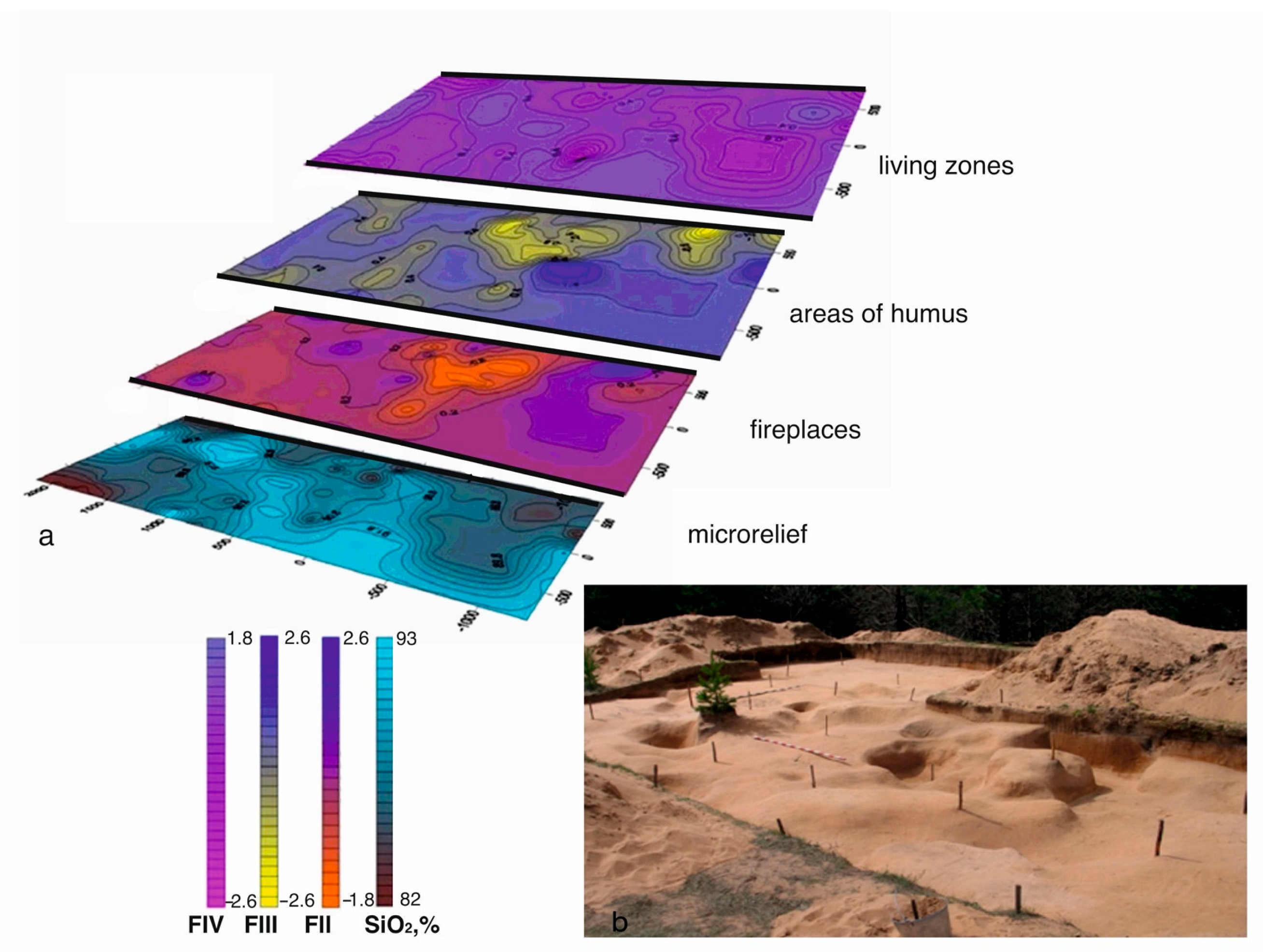
The second factor (FII) shows the antagonism of components associated with the fireplaces (K2O, Ba, TiO2) to lithogenic components (CaO, Na2O, SiO2). In places of increased concentrations of elements associated with wood ash, residues of charcoal and ash stains from hearths were found. The third factor (FIII) shows the antagonism between the complex of lithogenic components (K2O, Al2O3, Ba, CaO) and components (Fe2O3, MnO, Ctot), which are associated with the accumulation of humus and coincide with traces of habitation and internal areas of the dwellings. The fourth factor FIV (MgO, MnO, Fe2O3, TiO2/P2O5, and Ctot) is associated with areas of accumulation of organic matter and bone residues (P2O5, Ctot), which could be concentrated in areas of animal cutting and food preparation. Sherds from pottery were also found in these zones. Figure 3 shows geochemical maps on the base of indicators-factor load data, giving an idea of the position of various sites associated with anthropogenic activity and reflecting the spatial arrangement of various functional zones in the area of the settlement.
In deposits of the 2nd upper cultural horizon at the Serteya 3-3 site, the remains of temporary structures are recorded. According to the geochemical data of deposits from the 2nd cultural horizon, the factors influencing the formation of these deposits were also established (n = 28). FI (SiO2/Al2O3, Fe2O3, MgO, CaO) reflects the features of the microrelief. In depressions in this case, sand deposits were accumulated, which may indicate small ancient river channels. This matches well with the 3D reconstruction of the ancient surface. The areas of the fireplaces were determined by the indicator ratio K2Oantr = K2O/(K2O + Al2O3). Comparison of the anomalous K2Oantr values with charcoal accumulations in these zones shows a good correlation. It allows us to trace the change in the location of the hearths in space. Areas of concentration of bone residues were determined by the CaO/SiO2 ratio. The abnormal values match the locations where calcified bones were found. The distribution map of the positive values of the second factor shows the zones of humus content (Ba, MnO, TiO2). Negative values of the third factor FIII (MgO, K2O/P2O5, Ctot) indicate habitat areas (P2O5, Ctot). The integrated application of the geochemical method and the geomagnetic method [37], as well as the use of more accurate methods for measuring magnetic susceptibility with a kappameter, makes it possible to detect traces of unreadable structures during excavations and obtain data for determination of zones associated with human activity. Such sites have been recorded in the cultural layer at the multilayer site of the Neolithic period Serteya XIV [18,37]. In addition to the main indicators of anthropogenic activity, the comparison of geochemical data and geophysical anomalies also made it possible to obtain additional information on other indicator elements that may be associated with biogenic processes and human activities. Elevated concentrations of iron oxides Fe2O3 and FeO appear around plant roots and may characterize the remains of decayed stumps [37]. High anomalous concentrations of iron oxides (Fe2O3 and FeO) also correspond to the localization of long-term fires. Accumulation of lead (Pb) may be associated with hearths, or with deposits of humus under reducing conditions [24,25,26,27,28,29]. In this archaeological context, the distribution of Pb correlates with the accumulation of K2Oantr in wood ash. The accumulation of copper (Cu) can also be associated with reducing conditions and concentrates in the areas of the fireplaces. According to geochemical indicators, high values of such indicators as K2Oantr, Cu, and Pb were established, which can be explained by the accumulation of ash or the localization of a small hearth that was not visually detected during excavations.
3.2. Sredny Peninsula, the Cult Place “Bratja”
The method of geochemical indication makes it possible to establish several main factors influencing the process of sedimentation at the archaeological sites and to identify anthropogenic components, if they were present in the deposits (n = 40). The formula of the first factor (FI): CaO, P2O5 (Sr)/Al2O3, SiO2, TiO2 (Zr) shows antagonism based on negative and positive correlation between the groups of components associated with anthropogenic activity; the association of components (CaO, P2O5 (Sr)), which are characterized by high correlations and rock-forming and accessory components (Al2O3, SiO2; TiO2; (Zr)), was associated with the minerals of the sandy deposits [39]. The contents of anthropogenic components CaO, P2O5; (Sr; Rb) were also determined for sediments at two sites. In a comparison of the concentration of these elements with the background samples taken outside the site, anomalous concentrations in the sediments at the site stand out. Two anomalous zones are distinguished on both sites of the monument investigated by the complex of anthropogenic components. These zones can be considered places of ritual actions. In such zones, anomalous contents of anthropogenic potassium and rubidium have been recorded. Elevated concentrations of K2Oantr are associated with wood ash in the cultural layer and are a marker of the fireplace zone. This is also noted for the Rbantr values, which correlate well with K2Oantr. In the areas of fireplaces, which are enriched with ash, increased concentrations of zinc (Zn) and copper (Cu) are also registered. Thus, basic data obtained on the zones of fireplaces, as well as areas of ash emissions from them, located nearby, were reconstructed. It can be assumed that zones with elevated contents of a complex of elements such as P, Ca, K, Sr, Rb, Zn, and Cu mark areas of ancient ritual practice where sacred offerings could be left, animal meat was butchered, and there were fireplaces. Thus, according to geochemical studies, it can be concluded that, in the space between the two stone columns of the “Bratja” ceremonial, ritual actions were performed, which can be considered pagan sacrifices associated with hunting and household magic. These rocks could be perceived as expressive natural objects, endowed with sacred properties, and the areas near them were used for ritual practices. The ethnographical evidence of the ritual activity is known at this place [39].
3.3. Ladoga Lake Basin (Sites Okhta 1 and Podolye 1)
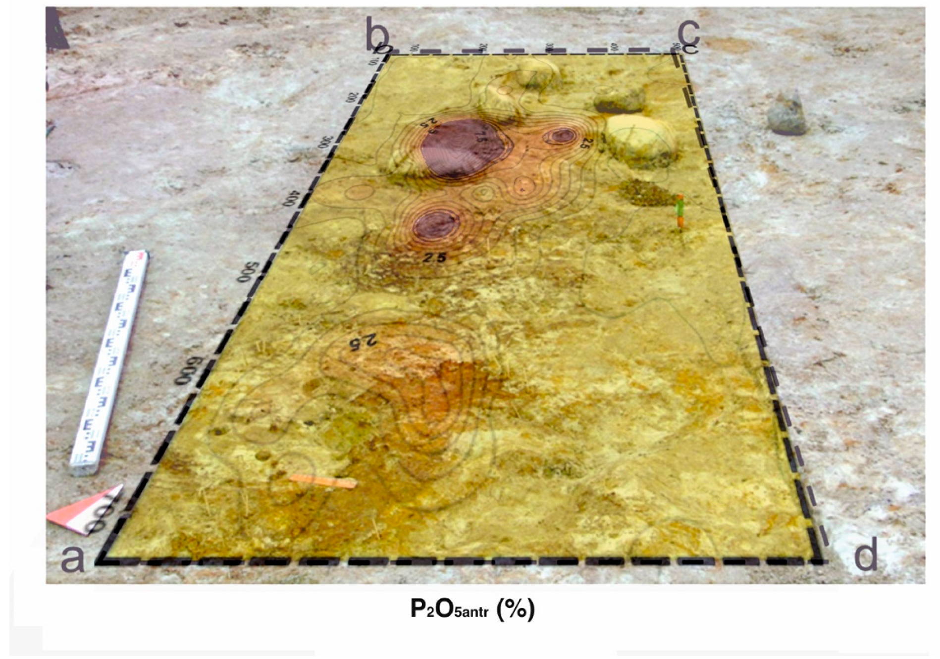
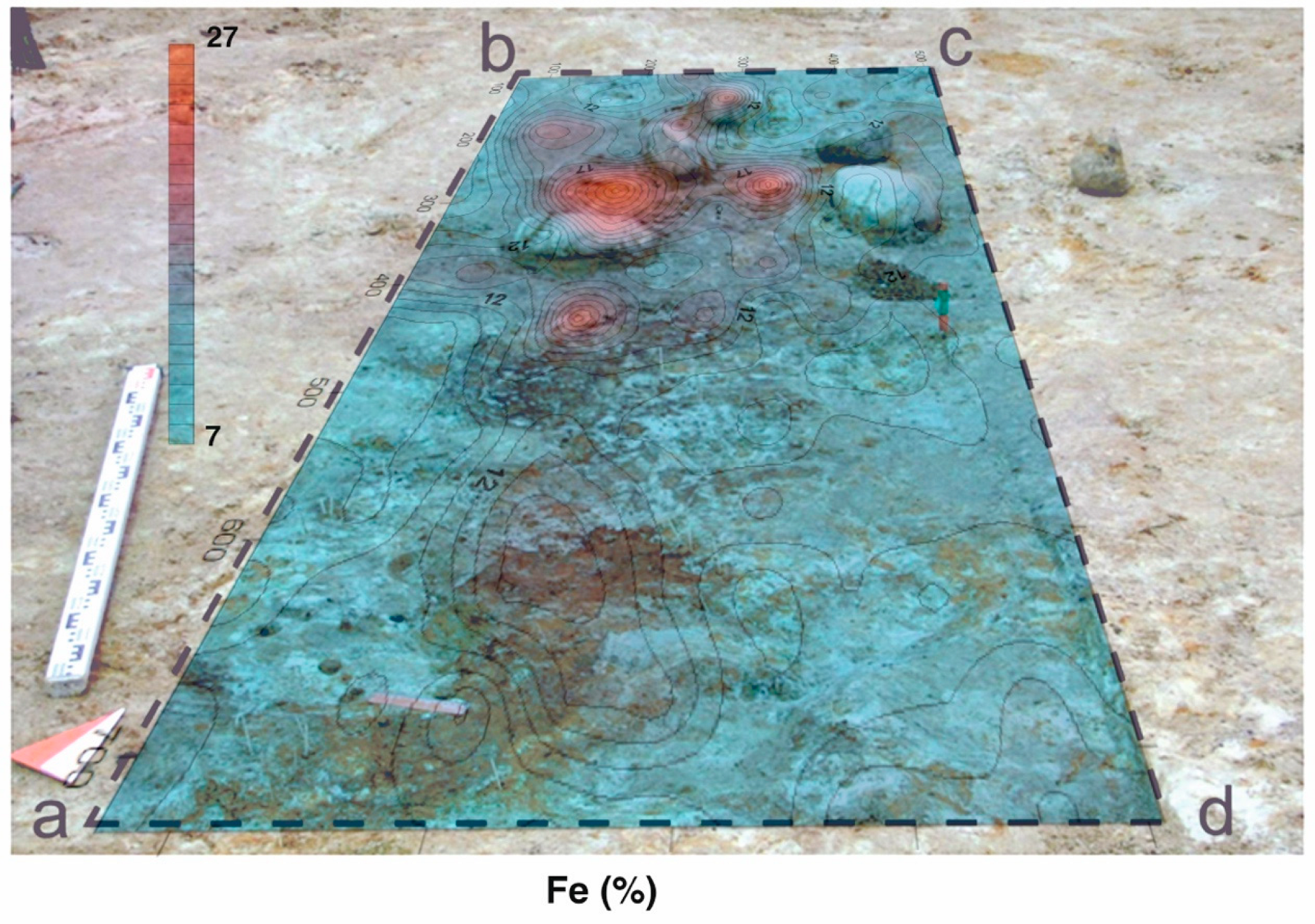
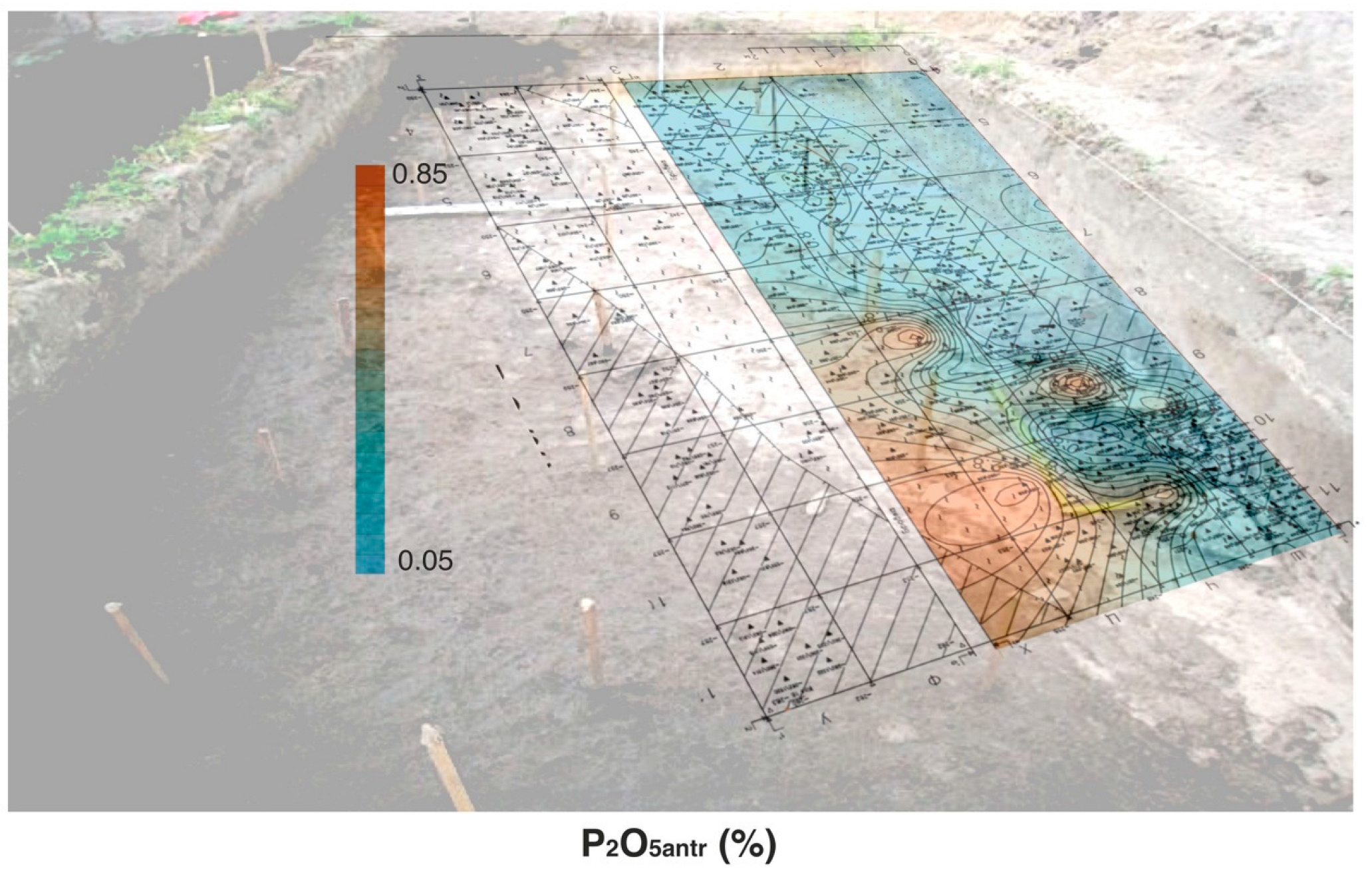
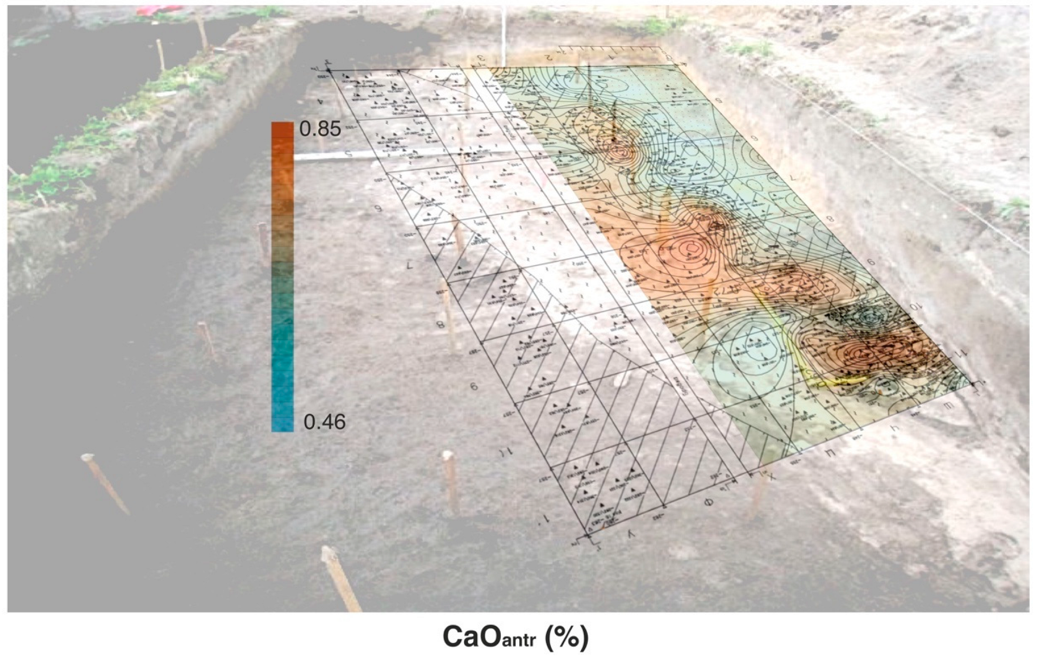
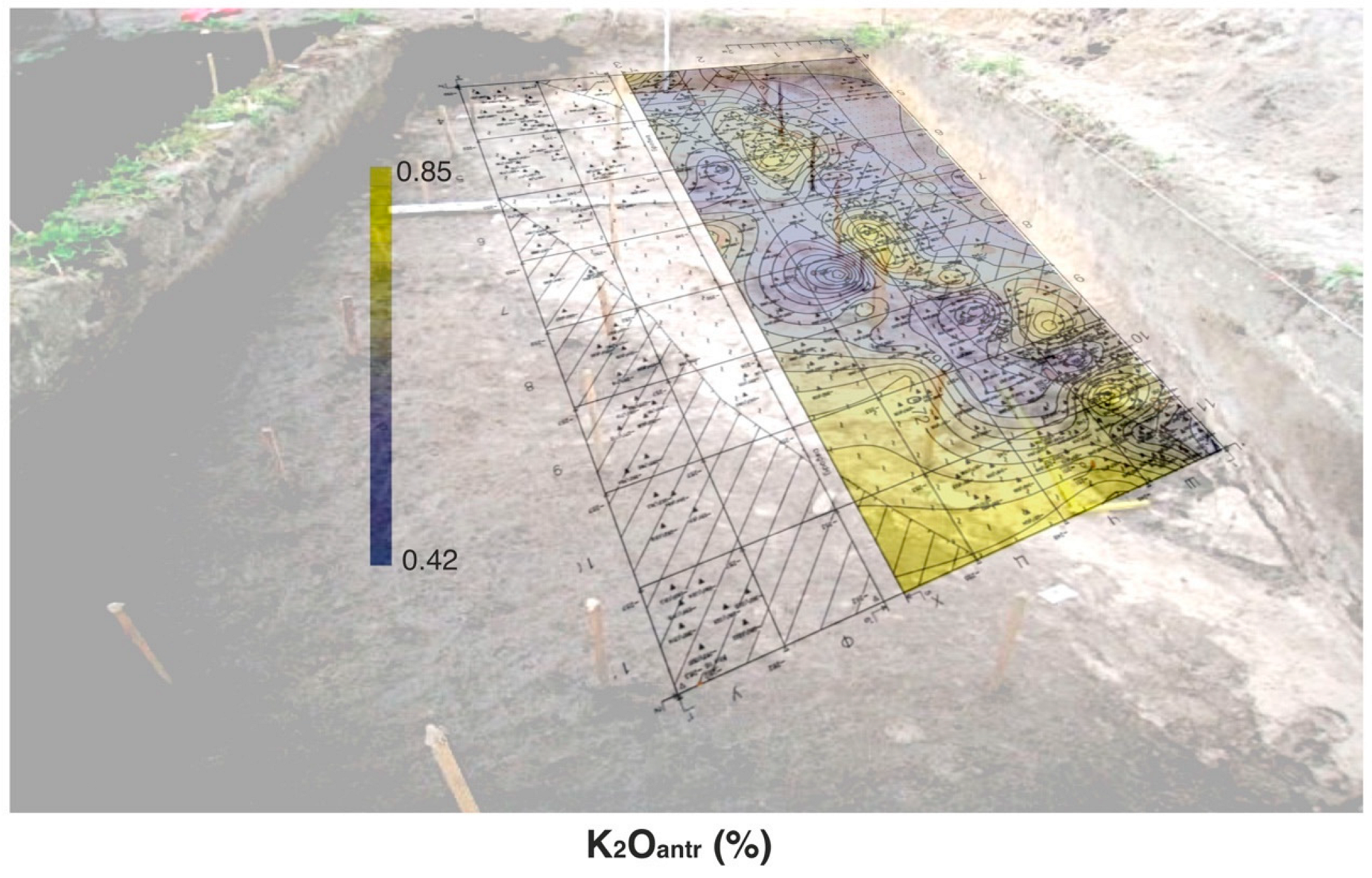
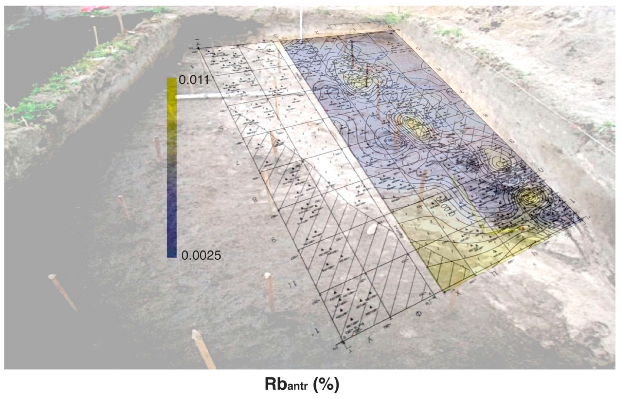
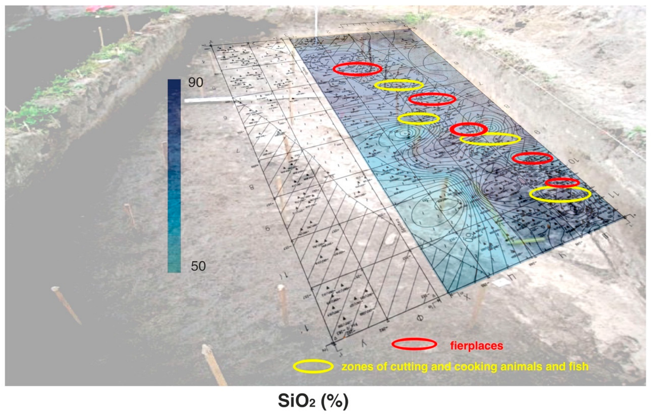
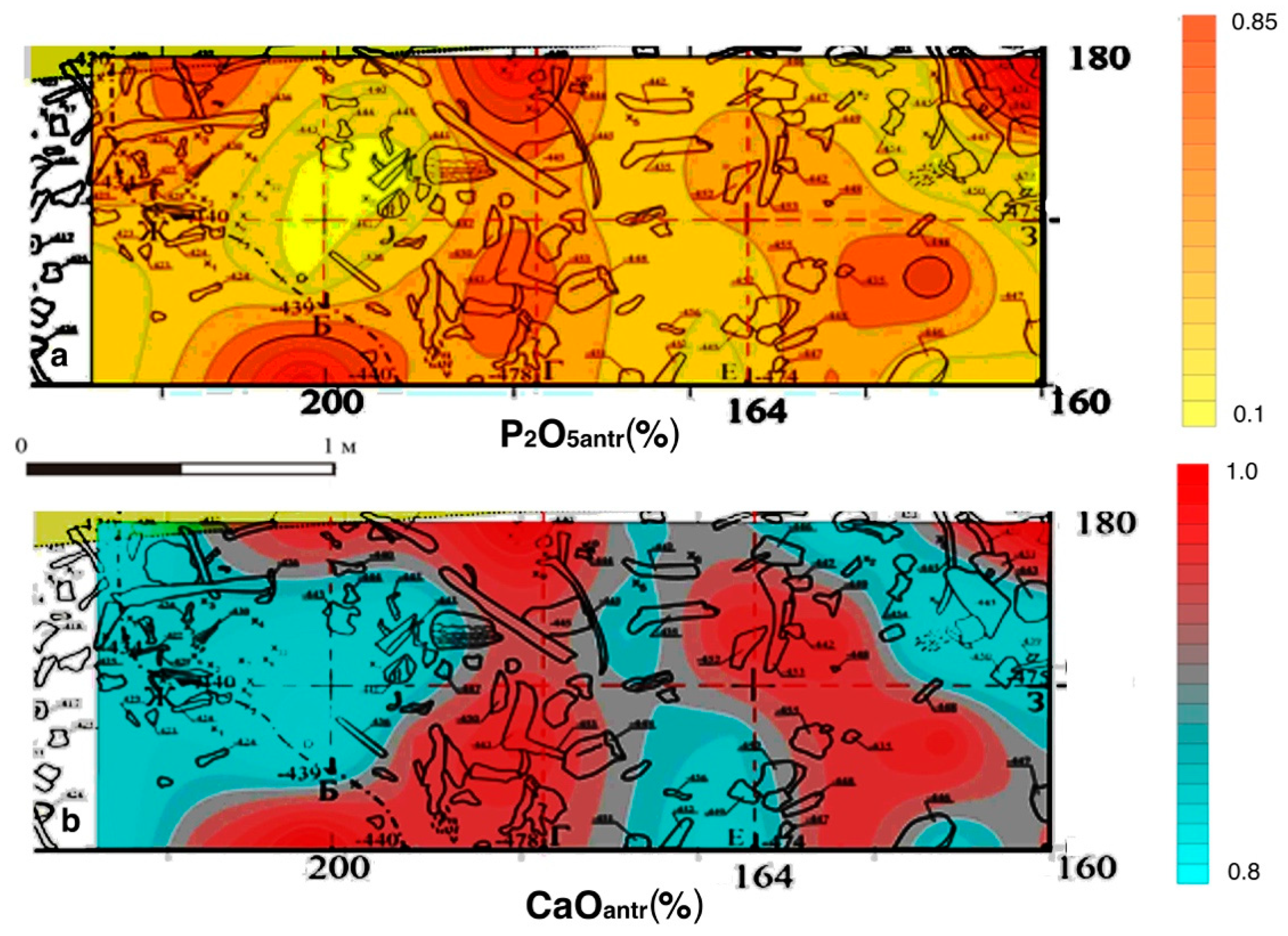
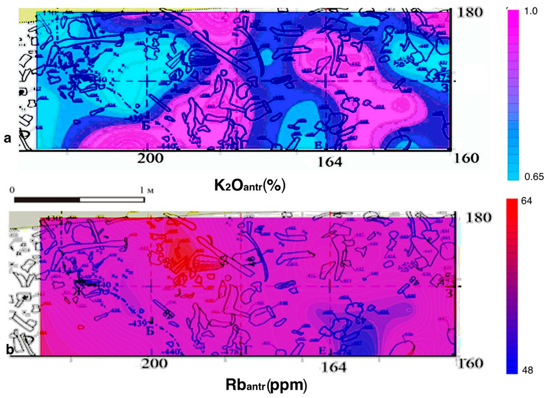
At the sites of Okhta 1 and Podolye 1, various types of functional zones were considered on the surface of cultural layers, which formed around 3300 calBC [35,38,40,41,42]. They are presented by soils and medium grain sands. At the Okhta 1 site, geochemical mapping data and the distribution of artifacts show the burial site (Figure 4, Figure 5 and Figure 6). The burial deposits are characterized by anomalous values of a complex of chemical anthropogenic components, such as P2O5antr, Cantr and Fe, Srantr. The geochemical composition of the deposits at the Podolye 1 site shows a different character of the distribution of geochemical elements (Figure 7, Figure 8, Figure 9 and Figure 10) [38]. On the terrace of the small river channel, there were seasonal fishing camps with fireplaces and places for cutting and cooking animals and fish. This is supported by the archaeological evidence [35,38]. A combination of such anthropogenic elements as K2Oanhtr, Rbantr, CaOantr, and Srantr stands out in the cultural layer of the sediments of this site. On the shore of the channel, it is possible to distinguish areas for the location of fireplaces (K2Oantr and Rbantr—elements that are accumulated in charcoal and wood ash) and areas for cutting and cooking animals and fish (CaOantr and Srantr—main elements of bone tissue). In the pit located on the terrace of the channel, another geochemical complex with anomalous values was characterized: K2Oantr, Rbantr, CaOantr, Srantr, Mnantr, Baantr, Fe, and P2O5anthr, which may indicate the accumulation of waste in the channel pit.: K2Oantr and Rbanhtr-components, which are part of ash and charcoal, P2O5 antr, CaOantr, Srantr are components of bone tissues, Mnantr, Baantr, and Fe are components that are part of decomposed organic matter. The distribution geochemistry of major sediment-forming elements such as alumina (Al2O3) and silica (SiO2) is an important factor in determining the ancient microrelief at this site (Figure 11). Associations of geochemical indicators from the same lithological context at the sites of Okhta 1 and Podolye 1 have different anthropogenic loads. The deposits from the burial are characterized by anomalous values of such bioindicators as P2O5anhtr and CaOantr, which are the main components of bones and tissues. Iron in the form of hematite (Fe2O3) is part of the ocher, which was used in the ritual ceremony.
3.4. Tarkhankut Peninsula (Crimea), Bronze Age Cattle Pens
Maps of the distribution of components (SiO2, Al2O3) associated with the lithological composition of the deposits show the features of the microrelief in the excavation area (Figure 12) [43]. Elevated areas are clearly distinguished, on which the stone walls of the corral were built, and low areas, in which cattle were kept inside stone structures. The sediments in these areas are heavily “trampled” and reworked. Elevated values of anthropogenic components (CaOantr, K2Oantr, P2O5antr) in sediments in the areas of depression inside the paddocks indicate intense anthropogenic activity associated with livestock management (Figure 13). These sites are also characterized by high values of the main anthropogenic components, compared with the background site, outside the paddocks. The aggressive chemical environment, which changed the chemical composition of the sediments and led to the almost complete dissolution of carbonates, was formed in the conditions of the cattle stable, which is also confirmed by archaeological evidence. The content of CaO in the paddocks is much lower than in the background deposits (Figure 13). Anomalies of anthropogenic K2Oantr and Ba, which are associated with the processes of formation of humus, manure, etc. are also noted in paddock areas. Thus, according to the data of geochemical elements, it is possible to determine the main function of this area as a pen-stall for keeping animals.
3.5. The Upper Paleolithic Site Yudinovo
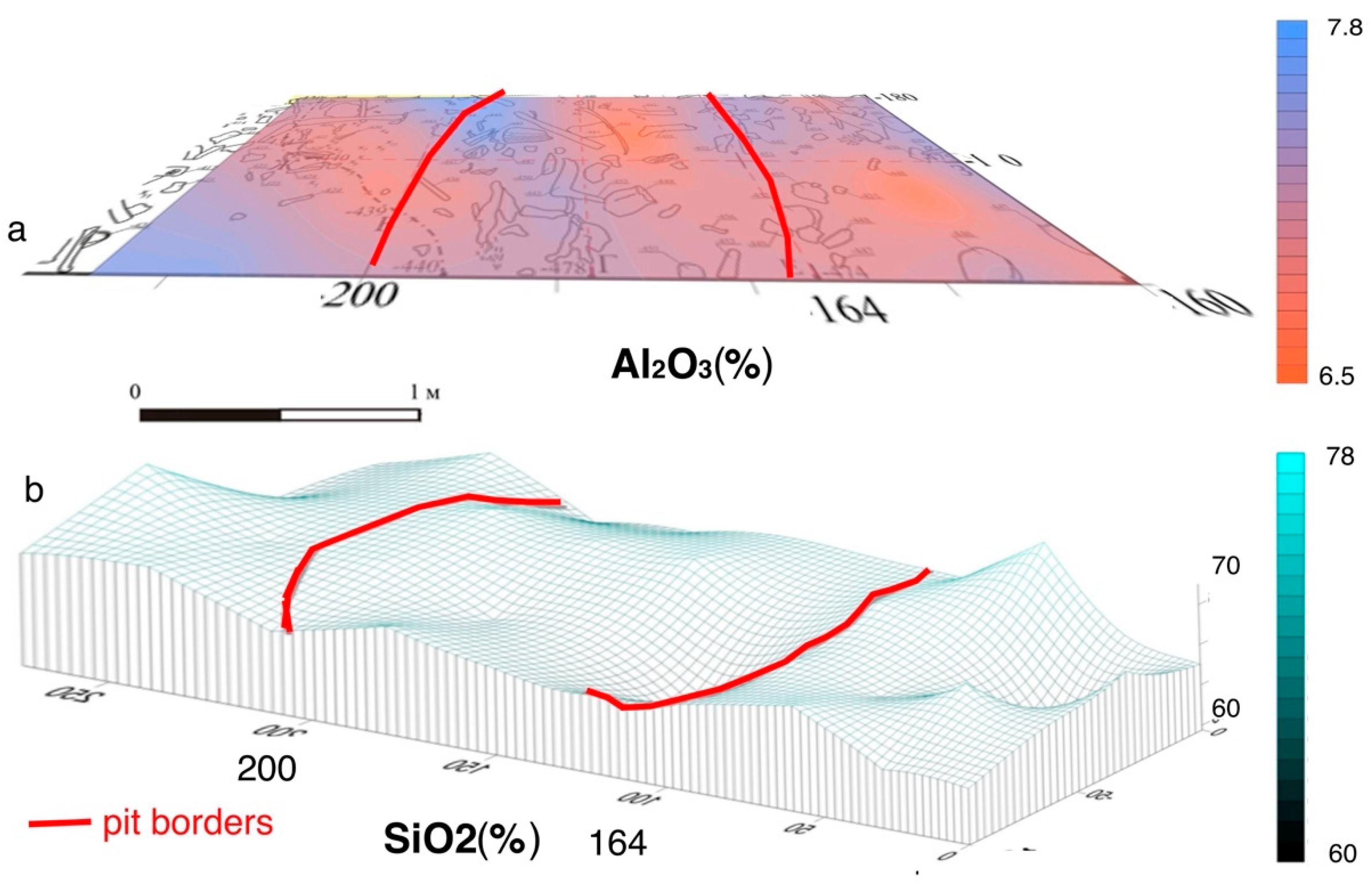
The cultural deposits at the Yudinovo site consist of Pleistocene loess and sandy loam. The geochemical results were considered in the article [44]. Important indicators for assessment of the ancient microrelief are changes in the content of the main rock-forming components (Al2O3)-alumina and (SiO2)-silica. 3D geochemical maps of Al2O3 and SiO2 distributions can be used for reconstruction of ancient microrelief in the area of the excavation (Figure 14). Elevated concentrations of alumina (Al2O3) are associated with depressions in the relief, where loam deposits accumulate. Low concentrations of SiO2 also mark areas of depressions in the relief. Silica, which is associated with the sandy component, is confined to elevated areas and is associated with areas of gray sandy loam in the excavation area. Elevated areas are composed of gray sandy loam enriched in silica and depleted in alumina; they mark the layer in squares t-28 and t-29, and are also noted in the middle part of square t-30, on the border with the pit-depression. It is possible that the sand could have been specially brought by ancient people to this place.
Geochemical maps of the distribution of complex of anthropogenic components, such as phosphorus (P2O5antr), calcium (CaOantr), potassium (K2Oantr), and rubidium (Rb) (Figure 15 and Figure 16) show areas associated with burnt bone remains. The largest accumulations are associated with depressions in the relief. Such zones are observed on the surface of the depression in squares t-28 and t-29 and form ring structures. A zone with high contents of the complex of these anthropogenic elements is also recorded in the T-30 square on the border of the “ash pit” and the pit-depression. The second group of chemical components (Fe2O3, MnO, Ba) may be connected with the location of organic residues (skins, wood, etc.), which were subject to decomposition and decay. High concentrations of these elements are noted in the ash pan deposits. The zone of high concentrations of these elements is confined to the border of the squares t-29 and t-30, which are planigraphically connected with the edge of the “ash pan”. The layer with high concentrations of these elements “flows” further into the “pit-depression” zone. Anomalous arsenic (As) concentrations are recorded in the area of square t-30, in its middle part. Some contents of arsenic (As), lead (Pb), and zinc (Zn) are also noted in the deposits of the “ash pan”.
Data on anthropogenic chemical elements make it possible to reconstruct the following structures on the surface of the studied area of the Yudinovo site: firstly, the upper cultural horizon above the pit-depression is characterized by increased contents of a complex of components that are associated with burnt bones: phosphorus (P2O5anthr), calcium (CaOantr), potassium (K2Oantr), and rubidium (Rb), which allows us to consider it as a separate cultural layer with bone remains; secondly, in the layer of the ash pit, which belongs to the main, lower cultural layer, there are high concentration (Fe2O3, MnO, Ba), elements associated with decomposed organic residues, such as skins, wood, etc. The totality of these chemical elements is also concentrated in deposits associated with deposits in the filling of the pit-depression, especially increased concentrations of elements in the deposits on the sides of the pit-depression, into which the ash pan layer falls. Along with this complex of elements, elevated contents of arsenic (As), lead (Pb), and zinc (Zn) are recorded in the ash pan deposits at the edge of the depression. It is known that the concentrations of these elements increase in a reducing environment, during the decomposition of organic matter. In addition, a complex of such elements as arsenic (As), zinc (Zn), and lead (Pb) can be associated with various components that make up the substances, the sources of which were located far from the Yudinovo site. For example, realgar is a red arsenic sulfide mineral, which, according to geological maps, is not found in the region where this archaeological site is located. The nearest sources of that mineral could be regions of Ukraine and Caucasus.
4. Discussion
Multicomponent statistical analysis of the geochemical composition of loose Quaternary deposits at archaeological sites located in Eastern Europe makes it possible to identify geochemical elements associated with both the lithological component of deposits and anthropogenic elements that accumulate in deposits as a result of the activities of prehistoric people. Such an approach allows identification of insoluble mineral and organo-mineral compounds that are formed as a result of the ancient anthropogenic activity at the sites. On the other hand, the distribution of the main rock-forming geochemical elements, such as Si (silicon) and Al (aluminum) in sediments on the area of settlements, allows us to establish the features of the microrelief on the site that existed during the period of occupation of the ancient population. This is important for multi-layer sites. At the Serteya 3-3 site, the upper and lower Neolithic cultural layers were formed as a result of the transformation of dune sand deposits under the influence of various anthropogenic activities. According to geochemical data, it is possible to distinguish zones in the settlement enriched in the sandy component in elevated areas, characterized by an association of elements (SiO2, Zr) and areas of depressions in the relief enriched in the clay-mica component (Al2O3, TiO2, Fe2O3, MgO, Na2O).
Comparison of the 3D surface of this paleorelief with archaeological data [37] makes it possible to reconstruct the contours of residential structures, pits from tree roots, and natural depressions in the relief that are not associated with an anthropogenic activity. Features of the microrelief reconstructed on the data of lithological geochemical elements were analyzed on the studied sites. At the Paleolithic site Yudinovo on the surface of loess cultural deposits, there are elevated parts with sediments enriched by SiO2 and lower areas with high Al2O3 concentrations of loess. Analysis of the distribution of SiO2 in loess deposits in different parts of the site and comparison with archaeological data on the distribution of finds and structural features also makes it possible to identify artificial sand beds [44]. Geochemical mapping of the coastal zone of the ancient channel at the Podilye 1 site, composed of sandy-silty deposits, also makes it possible to identify microrelief features according to the data of the distribution of alumina (Al2O3) and silica (SiO2). Comparison with anthropogenic geochemical indicators (K, Rb) determined the lowland zones-pits associated with fireplaces. According to the geochemical data of sand deposits at the Tarkhankut 18 site, the distribution of components (SiO2, Al2O3) in the deposits also fixes the features of the microrelief in the paddock zones and artificial sand bedding, which was used in the construction of the stone fences of the paddocks.
At all sites under studies, despite the deposits having a different genesis, it is possible to reliably identify groups of anthropogenic geochemical elements in cultural layers, which reflect various functional zones of ancient anthropogenic activity. At the Serteya 3-3 site, a group of geochemical elements is distinguished in the cultural deposits of the lower horizon. P2O5, CaO, MnO, and Ctot are components of carbonate-apatite of bone tissues and teeth, with organic residues. In the sediments of the upper cultural horizon, an association of elements (P2O5, Ctot) was determined. Anomalous concentrations of these elements in the sediments at the site are associated with animal butchering zones. This is confirmed by archaeological material and the remains of calcined bones and ceramic fragments accumulated inside these areas. At the Okhta 1 site, high concentrations of the group of elements P2O5antr, CaOantr and Fe2O3, Sranthr are associated with the burial zone. In the sediments, in addition to P2O5antr, CaOantr, and Sranthr, a high content of Fe2O3 is also recorded, which is associated with the ocher component. Geochemical maps of individual element distributions show the same contours, which coincide with the stonework in which the amber adornments were found. On the shore zone of the Podolye 1 site, a different pattern of distribution of elements P2O5antr, CaOantr, and Srantr is observed. They are concentrated in depressions of the relief in separate spots. These zones were probably used for butchering animals. Pottery sherds were found in these zones. At the Yudinovo site, an association of elements (P2O5antr), calcium (CaOantr) and, additionally, potassium (K2Oantr) and rubidium (Rb) is distinguished, the anomalous values of which are associated with depressions in the relief, in which burnt bones were found. Pits could be both utilitarian and ritual purposes. At the cult site “Bratja”, a complex of anthropogenic components CaO, P2O5, (Sr, Rb) is distinguished in the sediments, which can be associated with remains of bones and ashes. Along with these elements, increased concentrations of other elements, such as K2Oanthr, as well as microelements Zn, Cu, are recorded. Such an association of elements in sediments may characterize ritual activity. An interesting situation is observed at the Tarkhankut 18 site, which is a cattle pen. An association of anthropogenic components (CaOantr, K2Oantr, P2O5antr) is distinguished, the anomalous values of which are typical for deposits inside stone pens. At the same time, CaOantr concentrations are an order of magnitude lower than in sediments outside the paddocks. This is due to the dissolution of the carbonate component of sediments as a result of the vital activity of animals.
The complex of elements (K2Oantr, Rbantr) in cultural deposits at all sites is associated with the remains of charcoal and wood ash. At the sites of Serteya 3-3, Okhta 1, and Podolye 1, anomalous concentrations of these elements are connected with fireplaces. The sediments also contained charcoal inclusions. The association of elements (K2Oantr, Ba, MnO, Copr) can characterize zones of decomposed organics (skins, wood, food residues) and humus rich sediment zones.
For the reconstruction of various factors influencing on the cultural deposit formation, an approach has been developed using multivariate factorial and correlation matrix analyses. It possible in this case to identify individual groups of geochemical elements and their associations for characteristics of anthropogenic or natural factors influencing sediment composition [1,18,45]. Another important criterion for detailed interpretation of geochemical data is archaeological information about the site. Using complex research methods, such as geochemical, geophysical, and archaeological analysis in the assessment of an archaeological site, in detail for all the features of life, including household activity, pottery manufacturing, ancient metallurgy, etc. can be reconstructed [18,36,38]. An assessment of the distribution of anomalous concentration of certain elements or associations of elements at archaeological sites has shown that the interpretation of the data obtained cannot always be unambiguous and depends on many factors [46,47]. For example, the technogenic impact on the distribution of the chemical elements at the archaeological site located in the industrial zone has been considered by authors in the Central Greece region [48]. The authors introduce the term “equifinality” for chemical elements which are characterized by multiple sources. An important question in the interpretation of geochemical data is also the geochemical explanation that the accumulation of one or another chemical element is of an anthropogenic nature and is not related to the mineral composition of deposits at a given site and excluded other factors of contamination [49].
5. Conclusions
The assessment of the impact of anthropogenic activity on the transformation of sediments and the formation of cultural layers on the ancient settlements was carried out using the method of geochemical indication of functional zones on settlements. Thus, it is possible to note the main associations of anthropogenic elements in sediments at archaeological sites that characterize certain functional zones. Abnormal concentrations of such complex association of components (P2O5antr, CaOantr and Srantr) in sediments are attributed to zones of accumulation of bone remains. A more precise and detailed interpretation of functional zones (animal dressing zone, burial, ritual zone, waste pit) can be possible using other additional geochemical markers and archaeological context. Anomalous concentrations of a group of elements (K2Oantr, Rbantr) at archaeological sites are associated with wood ash residues and fireplaces, ash residues from ritual activities, and fires. The group of components (Ba, MnO, Corg) reflects the accumulation of humus and organic residues, and can characterize areas with food residues, remains of skins, and rotten wood. Combinations of the main groups of elements may also indicate various other types of functional zones, living zones, household areas, and places of ritual purposes. 3D geochemical maps of Al2O3 and SiO2 distributions can be used for the reconstruction of ancient microrelief at the sites. Data from the archaeological context should be studied to carry out more detailed reconstructions. Using a geochemical multicomponent approach, even in complex geo-morphological contexts, anthropogenic geochemical indicators can be used to reconstruct functional zones at ancient settlements.
Funding
This research was funded by RSF, project No. 22-18-00065 “Cultural and historical processes and paleoenvironment in the Late Bronze-Early Iron Age of the North-Western Black Sea region: interdisciplinary approach” and the project with financial support from the Ministry of Education of the Russian Federation under program No. FSZN-2020-0016.
Institutional Review Board Statement
Not applicable.
Informed Consent Statement
Informed consent was obtained from all subjects involved in the study.
Data Availability Statement
Not applicable.
Conflicts of Interest
The author declares no conflict of interest. The funders had no role in the design of the study; in the collection, analyses, or interpretation of data; in the writing of the manuscript; or in the decision to publish the results.
References
- Oonk, S.; Slomp, C.P.; Huisman, J.D. Geochemistry as an aid in archaeological prospection and site interpretation: Current issues and research directions. Archaeol. Prospect. 2009, 16, 35–51. [Google Scholar] [CrossRef]
- Entwistle, J.A.; Abrahams, P.W.; Dodgshon, R.A. Multi-Element Analysis of Soils from Scottish Historical Sites. Interpreting Land-Use History Through the Physical and Geochemical Analysis of Soil. J. Archaeol. Sci. 1998, 25, 53–68. [Google Scholar] [CrossRef]
- Wilson, C.A.; Davidson, D.A.; Cresser, M.S. An evaluation of multielement analysis of historic soil contamination to differentiate space use and former function in and around abandoned farms. Holocene 2005, 15, 1094–1099. [Google Scholar] [CrossRef]
- Aston, M.; Martin, M.; Jackson, A. The use of heavy metal soil analysis for archaeological surveying. Chemosphere 1998, 37, 456–477. [Google Scholar] [CrossRef]
- Cabala, J.; Smieja-Kroól, B.; Jablonska, M.; Chrost, L. Mineral components in a peat deposit: Looking for signs of early mining and smelting activities in Silesia–Cracow region (Southern Poland). Environ. Earth Sci. 2013, 69, 2559–2568. [Google Scholar] [CrossRef]
- Lutz, H.J. The concentration of certain chemical elements in the soils of Alaskan archeological sites. Am. J. Sci. 1951, 249, 925–928. [Google Scholar] [CrossRef]
- Schlezinger, D.R.; Howes, B.L. Organic Phosphorus and Elemental Ratios as Indicators of Prehistoric Human Occupation. J. Archaeol. Sci. 2000, 27, 479–492. [Google Scholar] [CrossRef]
- Terry, R.E.; Hardin, P.J.; Houston, S.D.; Nelson, S.D.; Jackson, M.W.; Carr, J.; Parnell, J.J. Quantitative phosphorus measurement: A field test procedure for archaeological site analysis at Piedras Negras, Guatemala. Geoarchaeol. Int. J. 2000, 15, 151–166. [Google Scholar] [CrossRef]
- Tian, X.S.; Zhu, C.; Sun, Z.B.; Shui, T. An evaluation of heavy metal pollution within historic cultural strata at a specialized salt production site at Zhongba in the Three Gorges Reservoir region of the Yangtze River, China. Environ. Earth Sci. 2013, 69, 2129–2138. [Google Scholar] [CrossRef]
- Wells, E.C.; Terry, R.E.; Parnell, J.J.; Hardin, P.J.; Jackson, M.W.; Houston, S.D. Chemical analyses of ancient anthrosols in residential areas at Pieda Negras, Guatemala. J. Archaeol. Sci. 2000, 27, 449–462. [Google Scholar] [CrossRef]
- Sanchez, C.A. Phosphorus. In Handbook of Plant Nutrition; Barker, A.V., Pilbeam, D.J., Eds.; CRC Press: Boca Raton, FL, USA, 2007; pp. 51–90. [Google Scholar] [CrossRef]
- Marwick, B. Element concentrations and magnetic susceptibility of anthrosols: Indicators of prehistoric human occupation in the inland Pilbara, Western Australia. J. Archaeol. Sci. 2005, 32, 1357–1368. [Google Scholar] [CrossRef]
- Lima da Costa, M.; Kern, D. Geochemical signatures of tropical soils with archaeological black earth in the Amazon, Brazil. J. Geochem. Explor. 1999, 66, 369–385. [Google Scholar] [CrossRef]
- Wells, C. Investigating Activity Patterns in Prehispanic Plazas: Acid-extraction ICP-AES Analysis of Anthrosols at Classic Period El Coyote, Northwestern Honduras. Archaeometry 2004, 46, 67–84. [Google Scholar] [CrossRef]
- Proudfoot, B. The analysis and interpretation of soil phosphorus in archaeological contexts. In Geoarchaeology; Davidson, D.A., Shackley, M.L., Eds.; Cambridge University Press: Duckworth, London, UK, 1976; pp. 93–113. [Google Scholar]
- Stevenson, F.J. Cycles of Soil: Carbon, Nitrogen, Phosphorus, Micronutrients; Wiley Interscience: New York, NY, USA, 1986; p. 380. [Google Scholar]
- Middleton, W.D.; Price, T.D. Identification of Activity Areas by Multi-element Characterization of Sediments from Modern and Archaeological House Floors Using Inductively Coupled Plasma-atomic Emission Spectroscopy. J. Archaeol. Sci. 1996, 23, 673–687. [Google Scholar] [CrossRef]
- Kulkova, M.A. Metodi priklanih paleolandshaftnih geokhimicheskih issledovany. In Methods of Applied Paleolandscape Geochemical Investigations; Herzen State University Publisher: St. Petersburg, Russia, 2012; p. 152. ISBN 978-5-8064-1678-1. (In Russian) [Google Scholar]
- Cook, S.F.; Heizer, R.F. Studies on the Chemical Analysis of Archaeological Sites University of California Publications in Anthropology 2; University of California Publications: Berkeley, CA, USA; Los Angeles, CA, USA, 1965; p. 102. [Google Scholar]
- Keeley, H.C.M. Recent work on soil phosphorus analysis in archaeological prospection. Rev. D’archéométrie 1981, 95, 89–95. [Google Scholar] [CrossRef]
- Bethell, P.H.; Smith, J.U. Trace element analysis of an inhumation from Sutton Hoo, using inductively coupled plasma emission spectrometry: An evaluation of the techniques applied to analysis of organic residues. J. Archaeol. Sci. 1989, 16, 47–55. [Google Scholar] [CrossRef]
- Barba, L.; Ortiz, A.; Link, K.; Lopez-Lujan, L.; Lazos, L. The chemical analysis of residues in floors and the reconstruction of ritual activities at the Templo Mayor, Mexico. In Archaeological Chemistry: Organic, Inorganic and Biochemical Analysis; Orna, M.V., Ed.; American Chemical Society: Washington, DC, USA, 1996; pp. 139–156. [Google Scholar]
- Knudson, K.J.; Frink, L.; Hoffman, B.W.; Price, T.D. Chemical characterization of Arctic soils: Activity area analysis in contemporary Yuþik fish camps using ICP–AES. J. Archaeol. Sci. 2004, 31, 443–456. [Google Scholar] [CrossRef]
- Fernandez, F.G.; Terry, R.E.; Inomata, T.; Eberl, M. An ethnoarchaeological study of chemical residues in the floors and soils of Qéqchì Maya houses at Las Pozas, Guatamala. Geoarchaeology 2002, 17, 487–519. [Google Scholar] [CrossRef]
- Parnell, J.J.; Terry, R.E.; Golden, C. Using in-field phosphate testing to rapidly identify middens at Piedras Negras, Guatemala. Geoarchaeology 2001, 16, 855–873. [Google Scholar] [CrossRef]
- Zimmermann, W.H. Die Siedlungen des 1. bis 6. Jahrhunderts nach Christus von Flögeln-Eekhöltjen, Niedersachsen: Die Bauformen und ihre Funktionen. Probl. Der Küstenforschung Im Südlichen Nordseegebiet 1992, 19, 360S. [Google Scholar]
- Manzanilla, L. 1996. Soil analyses to identify ancient human activities. Can. J. Soil Sci. 1996, 76, 107–108. [Google Scholar] [CrossRef]
- Entwistle, J.A.; Abrahams, P.W.; Dodgshon, R.A. The geoarchaeological significance and spatial variability of a range of physical and chemical soil properties from a former habitation site, Isle of Skye. J. Archaeol. Sci. 2000, 27, 287–303. [Google Scholar] [CrossRef]
- Entwistle, J.A.; Dodgshon, R.A.; Abrahams, P.W. An investigation of former land-use activity through the physical and chemical analysis of soils from the Isle of Lewis, Outer Hebrides. Archaeol. Prospect. 2000, 7, 171–188. [Google Scholar] [CrossRef]
- Jenkins, D.A. Trace element geochemistry in archaeological sites. Environ. Geochem. Heatlth 1989, 11, 57–62. [Google Scholar] [CrossRef] [PubMed]
- Maskall, J.E.; Thornton, I. Chemical partitioning of heavy metals in soils, clays and rocks at historical lead smelting sites. Water Air Soil Pollut. 1998, 108, 391–409. [Google Scholar] [CrossRef]
- Pyatt, F.B.; Amos, D.; Grattan, J.P.; Pyatt, A.J.; Terrell-Nield, C.E. Invertebrates of ancient heavy metal spoil and smelting tip sites in southern Jordan: Their distribution and use as bioindicators of metalliferous pollution derived from ancient sources. J. Arid. Environ. 2002, 52, 53–62. [Google Scholar] [CrossRef]
- Monna, F.; Galop, D.; Carozza, L.; Tual, M.; Beyrie, A.; Marembert, F.; Chateau, C.; Dominik, J.; Grousset, F.E. Environmental impact of early Basque mining and smelting recorded in a high ash minerogenic peat deposit. Sci. Total Environ. 2004, 327, 197–214. [Google Scholar] [CrossRef]
- Ottaway, J.H.; Matthews, M.R. Trace element analysis of soil samples from a stratified archaeological site. Environ. Geochem. Health 1988, 10, 105–112. [Google Scholar] [CrossRef]
- Kulkova, M.A.; Gusentsova, T.M.; Sapelko, T.V.; Nesterov, E.M.; Sorokin, P.E.; Ludikova, A.V.; Ryabchuk, D.V.; Markova, M.A. Geoarcheological investigations on the development of the Neva River delta (Gulf of Finland) during the Holocene. J. Mar. Syst. 2014, 129, 19–34. [Google Scholar] [CrossRef]
- Kulkova, M.; Mazurkevich, A.; Gerasimov, D. Stone Age archaeological sites and environmental changes during the Holocene in the NW region of Russia. In Geology and Archaeology: Submerged Landscapes of the Continental Shelf; Harff, J., Bailey, G., Lüth, F., Eds.; Geological Society of London Special Publications 411: London, UK, 2015; pp. 27–49. [Google Scholar]
- Mazurkevich, A.N.; Dolbunova, E.V.; Kulkova, M.A.; Savelieva, L.A. Geoarchaeological Issues of the Upper Dnieper–Western Dvina River Region (Western Russia): Fieldtrip guide; Smolensk Universum: Moscow, Russia, 2012; p. 105. (In Russian) [Google Scholar]
- Kulkova, M.A.; Gusentsova, T.M.; Nesterova, L.A.; Nesterov, E.M. The reconstruction of functional zones at Neolithic to Early Iron Age sites in the Neva river basin (Russia) by means of geochemical markers. In Monographs of the Archaeological Society of Finland 7. Proceedings of the 11th Nordic Conference on the Application of Scientific Methods in Archaeology; Mannermaa, A., Manninen, M.A., Pesonen, P., Seppänen, L., Eds.; Archaeological Society of Finland: Helsinki, Finland, 2019; pp. 72–92. ISBN 978-952-68453-5-7. [Google Scholar]
- Shahknovich, M.M.; Kulkova, M.A. “Bratja” poluostrova Sredny Murmanskogo poberezhija Barenzeva morja. Opit identificazii saamskih sakral’nih objektov Russkoi Laplandii [“Bratja” of Sredny Isthmus of the Murmansky shore of Barents Sea. The experience of identification of Sami sacral objects of the Russian Lapland]. Archaeol. Arctic. 2020, 7, 300–326. (In Russian) [Google Scholar]
- Ryabchuk, D.; Zhamoida, V.; Amantov, A.; Sergeev, A.; Gusentsova, T.; Sorokin, P.; Kulkova, M.; Gerasimov, D. Development of the coastal systems of the easternmost Gulf of Finland, and their links with Neolithic–Bronze and Iron Age settlements. Geol. Soc. 2016, 411, 51–76. [Google Scholar] [CrossRef]
- Gesentsova, T.; Kulkova, M. The subsistence strategy and paleoenvironment on the Stone Age site Podolye 1 in the southern Ladoga Lake region (Eastern Baltic). Quat. Int. 2020, 541, 41–51. [Google Scholar] [CrossRef]
- Sapelko, T.V.; Gusentsova, T.M.; Kulkova, M.A.; Ludikova, A.V.; Denisenkov, V.P.; Korneenkova, N. Ladozhskaya transgressiya I landshafti vtoroi polovini golozena v Yuzhnom Prilagozhie (po dannim izucheniya arheologicheskogo pamyatnika Podolye) [Ladoga transgression and landscapes of the second half of Holocene in the Southern Ladoga Lake basin (on the data of study of archaeological site Podolye 1)]. Izvestiya RAS. Geogr. Ser. 2019, 5, 78–95. (In Russian) [Google Scholar] [CrossRef]
- Kashuba, M.T.; Smekalova, T.N.; Kulkova, M.A.; Gurov, E.Y. New Results of Interdisciplinary Study of Bronze Age Settlements in Northwestern Crimea. Vestn. St. Petersburg Univ. Hist. 2021, 66, 1270–1295. [Google Scholar] [CrossRef]
- Khlopachev, G.A.; Kulkova, M.A.; Gribchenko, Y.N. The characteristics of settlement structure formation on the Upper Paleolithic site of Yudinovo according to archaeological and geochemical investigations of 2015–2018. Strat. Plus 2022, 1, 239–258. [Google Scholar] [CrossRef]
- Nielsen, N.H.; Kristiansen, S.M. Identifying ancient manuring: Traditional phosphate vs. multi-element analysis of archaeological soil. J. Archaeol. Sci. 2014, 42, 390–398. [Google Scholar] [CrossRef]
- Barba, L. Chemical residues in lime-plastered archaeological floors. Geoarchaeology 2007, 22, 439–452. [Google Scholar] [CrossRef]
- Pecci, A. Almost ten years of plasters residue analysis in Italy: Activity areas and the function of structures. Period. Di Mineral. 2013, 82, 393–410. [Google Scholar]
- Bintliff, J.; Degryse, P.; van Zwienen, J. The long-term programme of trace metal analysis at the ancient city of Hyettos. J. Archaeol. Sci. Rep. 2022, 43, 103432. [Google Scholar] [CrossRef]
- Bintliff, J.; Degryse, P. A review of soil geochemistry in archaeology. J. Archaeol. Sci. Rep. 2022, 43, 103419. [Google Scholar] [CrossRef]
Figure 1.
Map of studied archaeological sites of Eastern Europe.

Figure 2.
Rocky remains “Bratja”—an object of the post-glacial geological history of Fennoscandia. The photo is by M. Shakhnovich [39].
Figure 2.
Rocky remains “Bratja”—an object of the post-glacial geological history of Fennoscandia. The photo is by M. Shakhnovich [39].

Figure 3.
(a) Spatial distribution of functional zones on the surface of the 1st cultural horizon of the Serteya 3-3 site according to geochemical mapping adapted from [37]; (b) surface of the 1st cultural layer [37], designed by M.Kulkova.

Figure 4.
Distribution of P2O5antr (%) on the surface of the burial layer at the Okhta 1 site [38], designed by M.Kulkova, a, b, c, d—burial area.
Figure 4.
Distribution of P2O5antr (%) on the surface of the burial layer at the Okhta 1 site [38], designed by M.Kulkova, a, b, c, d—burial area.

Figure 5.
Distribution of Caantr (ppm) on the surface of the burial layer at the Okhta 1 site [38], designed by M.Kulkova.
Figure 5.
Distribution of Caantr (ppm) on the surface of the burial layer at the Okhta 1 site [38], designed by M.Kulkova.

Figure 6.
Distribution of Fe (%) on the surface of the burial layer at the Okhta 1 site [38], designed by M.Kulkova.
Figure 6.
Distribution of Fe (%) on the surface of the burial layer at the Okhta 1 site [38], designed by M.Kulkova.

Figure 7.
Geochemical maps of P2O5anthr distributions in sediments on the surface of the cultural layer at the Podolye 1 site [38], designed by M.Kulkova.
Figure 7.
Geochemical maps of P2O5anthr distributions in sediments on the surface of the cultural layer at the Podolye 1 site [38], designed by M.Kulkova.

Figure 8.
Geochemical maps of CaOanthr distributions in sediments on the surface of the cultural layer at the Podolye 1 site [38], designed by M.Kulkova.
Figure 8.
Geochemical maps of CaOanthr distributions in sediments on the surface of the cultural layer at the Podolye 1 site [38], designed by M.Kulkova.

Figure 9.
Geochemical map of K2Oantr distribution in sediments on the surface of the cultural layer at the Podolye 1 site [38], designed by M.Kulkova.
Figure 9.
Geochemical map of K2Oantr distribution in sediments on the surface of the cultural layer at the Podolye 1 site [38], designed by M.Kulkova.

Figure 10.
Geochemical map of Rbantr distributions in sediments on the surface of the cultural layer at the Podolye 1 site [38], designed by M.Kulkova.
Figure 10.
Geochemical map of Rbantr distributions in sediments on the surface of the cultural layer at the Podolye 1 site [38], designed by M.Kulkova.

Figure 11.
Features of relief on the base of SiO2 distribution at the site surface and location of different types of functional zones based on geochemical reconstructions at the Podolye site [38], designed by M.Kulkova.
Figure 11.
Features of relief on the base of SiO2 distribution at the site surface and location of different types of functional zones based on geochemical reconstructions at the Podolye site [38], designed by M.Kulkova.

Figure 12.
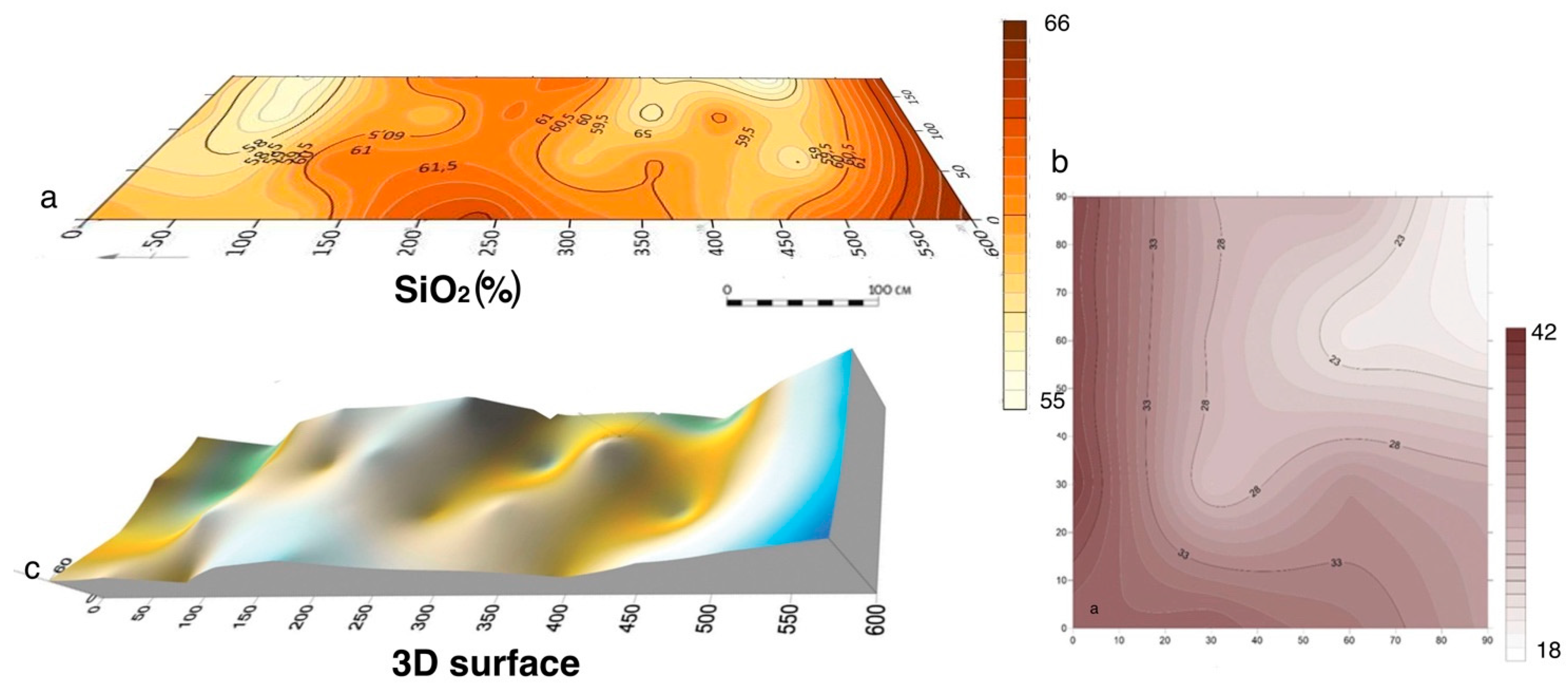
The Tarkhankhut 18 site. Geochemical maps of SiO2 distribution in the sediments of (a) inside cattle pen; (b) background pit; (c) 3D reconstruction surface based on SiO2 distribution [43], designed by M.Kulkova.
Figure 12.
The Tarkhankhut 18 site. Geochemical maps of SiO2 distribution in the sediments of (a) inside cattle pen; (b) background pit; (c) 3D reconstruction surface based on SiO2 distribution [43], designed by M.Kulkova.

Figure 13.
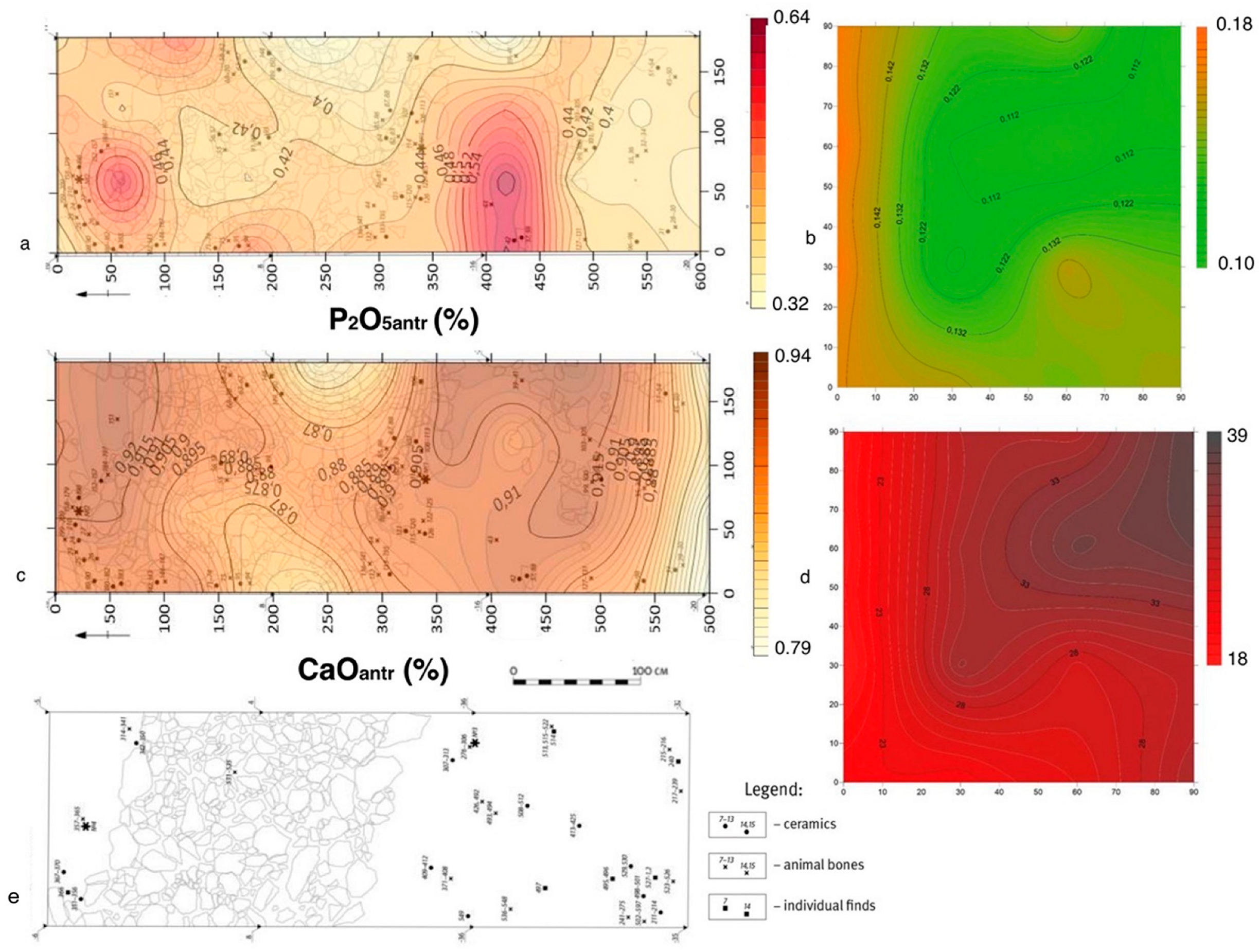
The Tarkhankhut 18 site. Geochemical maps of P2O5 distribution in the sediments of (a) inside cattle pen; (b) background pit; geochemical maps of CaO distribution in the sediments of (c) inside cattle pen; (d) background pit; (e) archaeological plan of cattle pen [43], designed by M.Kulkova.
Figure 13.
The Tarkhankhut 18 site. Geochemical maps of P2O5 distribution in the sediments of (a) inside cattle pen; (b) background pit; geochemical maps of CaO distribution in the sediments of (c) inside cattle pen; (d) background pit; (e) archaeological plan of cattle pen [43], designed by M.Kulkova.

Figure 14.
The Yudinovo site. Geochemical maps of (a) Al2O3 (b) 3D distribution of SiO2 in the sediments [44], designed by M.Kulkova.
Figure 14.
The Yudinovo site. Geochemical maps of (a) Al2O3 (b) 3D distribution of SiO2 in the sediments [44], designed by M.Kulkova.

Figure 15.
The Yudinovo site. Geochemical maps of (a) P2O5anthr and (b) CaOantr distributions in the sediments [44], designed by M.Kulkova.
Figure 15.
The Yudinovo site. Geochemical maps of (a) P2O5anthr and (b) CaOantr distributions in the sediments [44], designed by M.Kulkova.

Figure 16.
The Yudinovo site. Geochemical maps of (a) K2Oantr and (b) Rb distributions in the sediments [44], designed by M.Kulkova.
Figure 16.
The Yudinovo site. Geochemical maps of (a) K2Oantr and (b) Rb distributions in the sediments [44], designed by M.Kulkova.


Table 1.
The main characteristics of places of sampling.
| Archaeological Site | Geology and Soils | Climatic Zone | Age of Cultural Layer | Number of Analyzed Samples | Archaeological Excavations |
|---|---|---|---|---|---|
| The Serteya site | fluvioglacial sediments; sod-podzolic | temperate zone; average temperature in July +17 °C; average temperature in January −9 °C; precipitation 615–751 mm per year | Early Neolithic | 35 from the cultural 1st layer and 3 control samples; 28 from the cultural 1st layer and 3 control samples; square of 20 × 6 m | The State Hermitage Museum, St. Petersburg, A.N. Mazurkevich [36,37]. |
| The cult object “Bratja” | magmatic rocks; tundra soils | Northern coastline, tundra;average temperature in July +8 °C; average temperature in January −14 °C; precipitation 400 mm per year | Middle Ages | 40 from the cultural layer; 8 control samples; square of 15 × 6 m | Expedition of the National Museum republic of Karelia (Petrozavodsk), Dr. M.M. Shakhnovich [39] |
| Okhta 1 and Podolye 1 sites | morane and lake-glacial deposits; podzolic-gley soils | tundra; average temperature in July +17 °C; average temperature in January +3.3 °C; precipitation 635 mm per year | Neolithic and Early Metal Ages | 25 from the cultural layer at Okhta site and 3control samples; square of 500 × 700 cm 32 from cultural layer and 3 control samples at Podolye site; square of 8 × 6 m | The excavations of Dr. T.M.Gusentsova and P. Sorokin [40,41,42] |
| Tarkhankut-18 site | the aeolian deposits on limestones; light-chestnut soils | coastline, steppe zone; average temperature in July +24 °C; average temperature in January −8 °C; precipitation 120–700 mm per year | Late Bronze-Early Iron Age | 47 from the cultural layer 600 × 180 cm square; and 18 control samples from square of 90 × 90 cm | The excavations of Dr. M.T.Kashuba (IIMC RSA, St. Petersburg) and Prof. T.N. Smekalova (Crimea Federal University, Simferopol) [43] |
| Yudinovo site | loess deposits; loess soils | Temperate continental; average temperature in July +19 °C; average temperature in January −8 °C; precipitation 550–600 mm per year | Upper Paleolithic | from cultural layer control samples | The excavations of Dr. G.A.Khlopachev (MAE RSA, Kunstkamera Museum, St. Petersburg) [44] |
Publisher’s Note: MDPI stays neutral with regard to jurisdictional claims in published maps and institutional affiliations. |
© 2022 by the author. Licensee MDPI, Basel, Switzerland. This article is an open access article distributed under the terms and conditions of the Creative Commons Attribution (CC BY) license (https://creativecommons.org/licenses/by/4.0/).
Share and Cite
MDPI and ACS Style
Kulkova, M. Geochemical Indication of Functional Zones at the Archaeological Sites of Eastern Europe. Minerals 2022, 12, 1075. https://doi.org/10.3390/min12091075
AMA Style
Kulkova M. Geochemical Indication of Functional Zones at the Archaeological Sites of Eastern Europe. Minerals. 2022; 12(9):1075. https://doi.org/10.3390/min12091075
Chicago/Turabian StyleKulkova, Marianna. 2022. "Geochemical Indication of Functional Zones at the Archaeological Sites of Eastern Europe" Minerals 12, no. 9: 1075. https://doi.org/10.3390/min12091075
Note that from the first issue of 2016, this journal uses article numbers instead of page numbers. See further details here.