
Response of Travertine Dam to Precipitation over the Past 800 Years in Zabuye Salt Lake, Southwestern Tibetan Plateau

 ,
,
Abstract
:1. Introduction
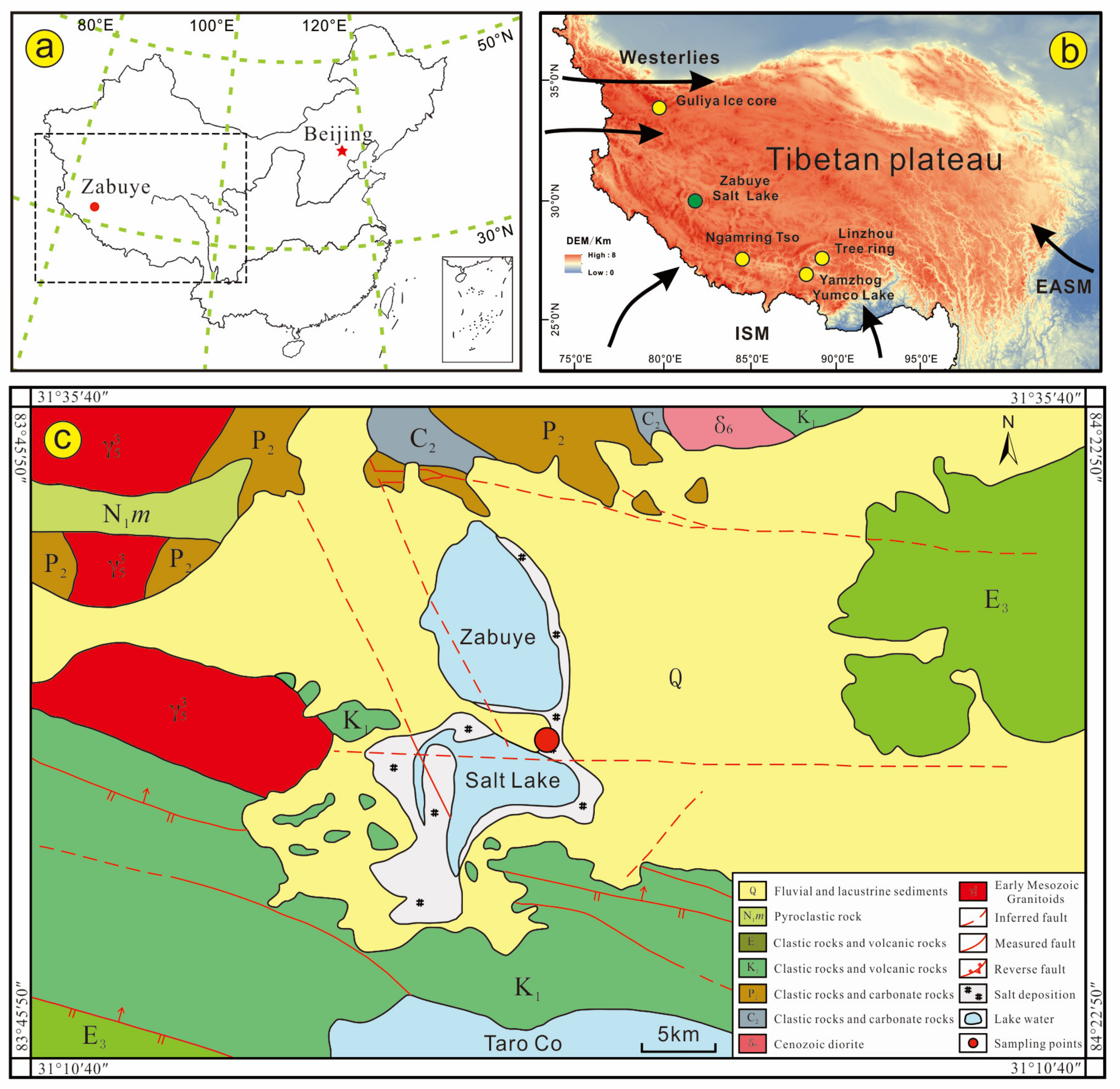
2. Geological Setting
3. Materials and Methods
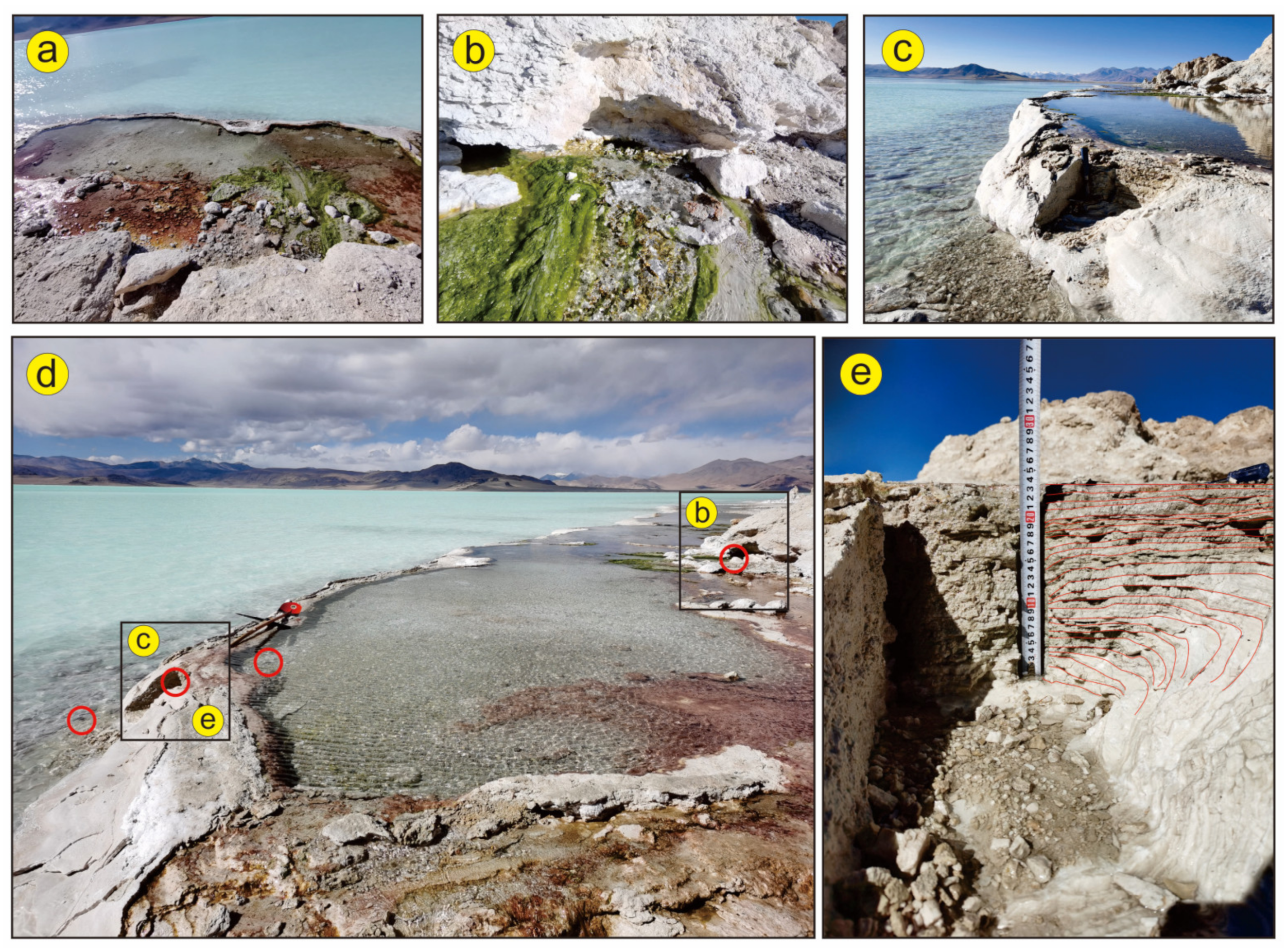
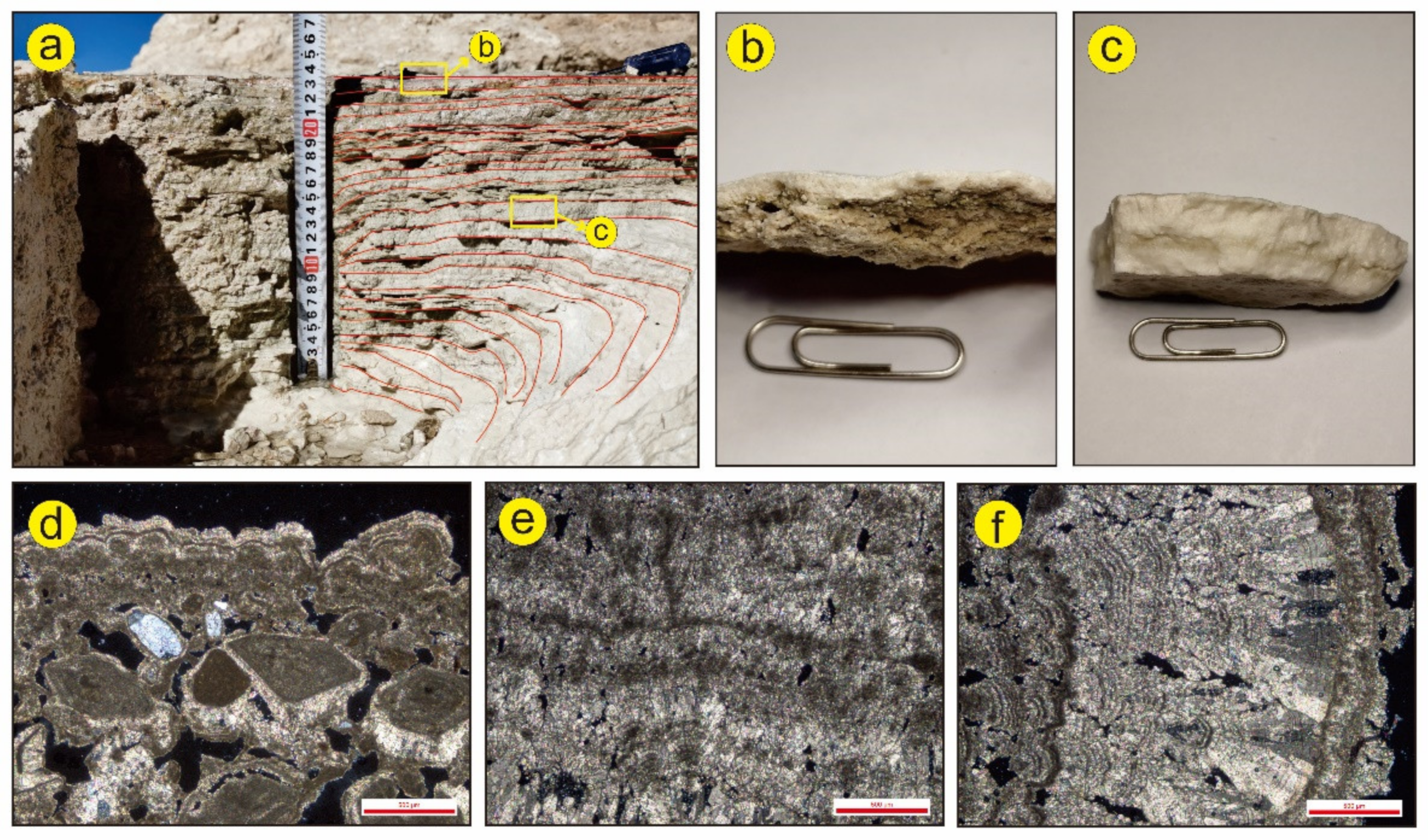
3.1. Research Materials
3.2. Analytical Methods
3.2.1. U–Th Dating
3.2.2. Petrography and Mineralogy
3.2.3. Stable Isotopes
4. Results
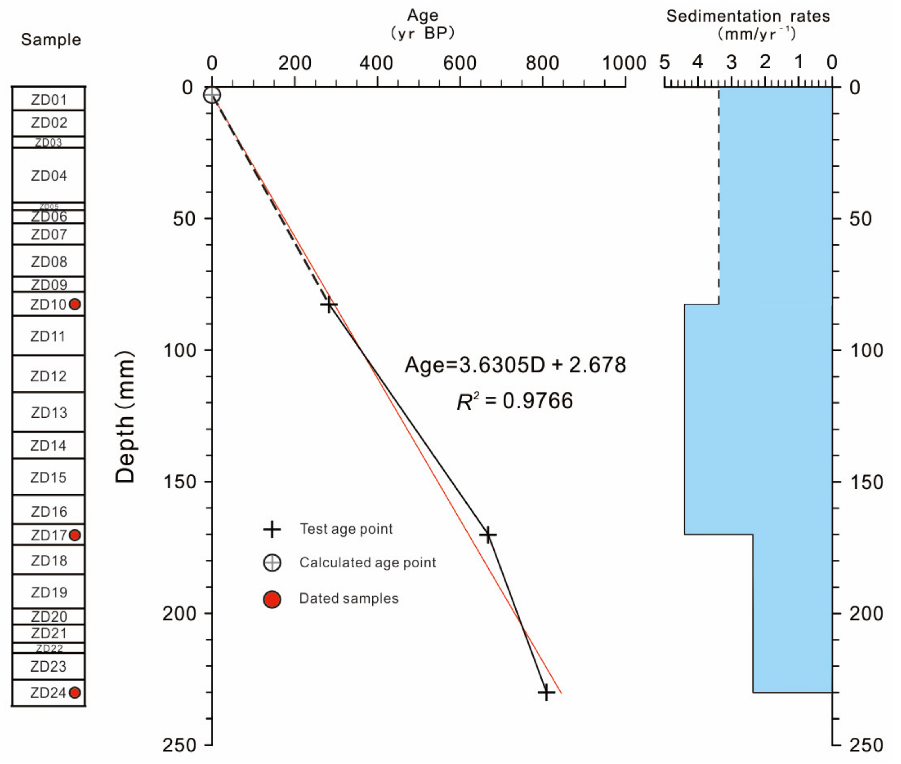
4.1. Chronology
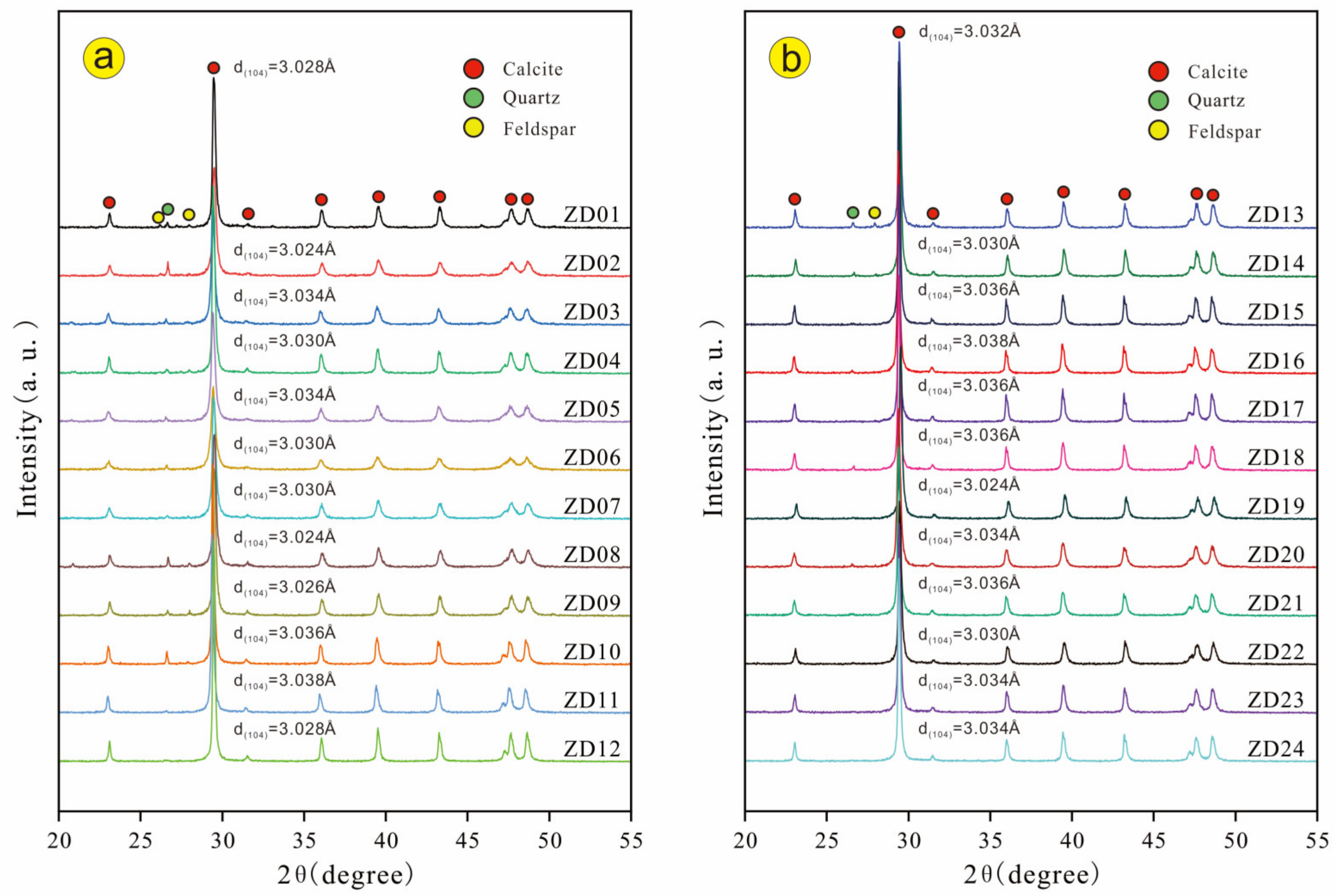
4.2. Petrography and Mineralogy
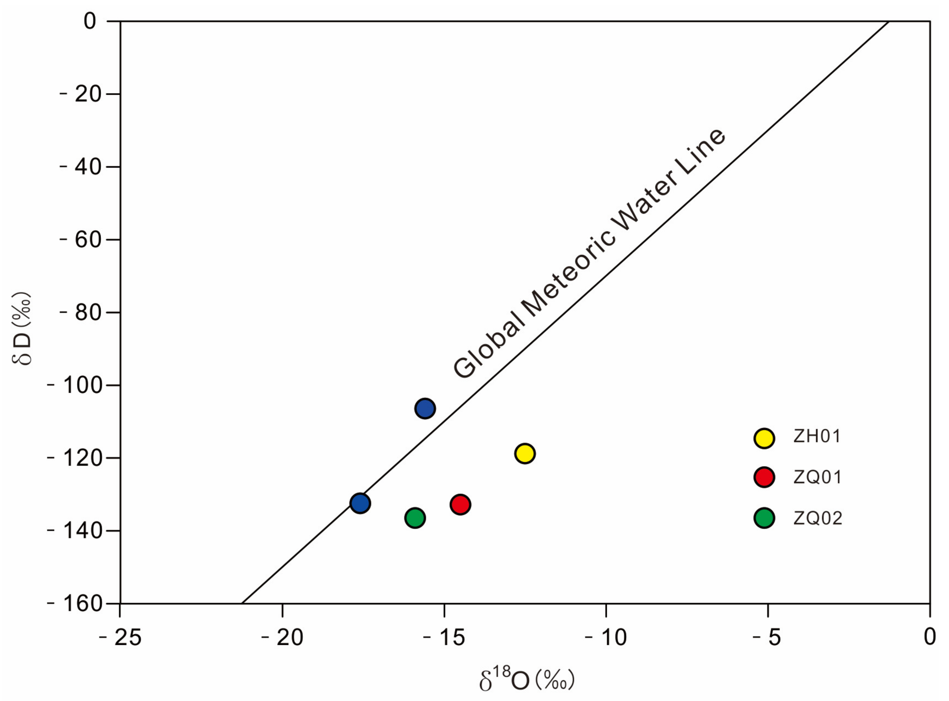
4.3. Hydrogen and Oxygen Isotopes of the Water Samples
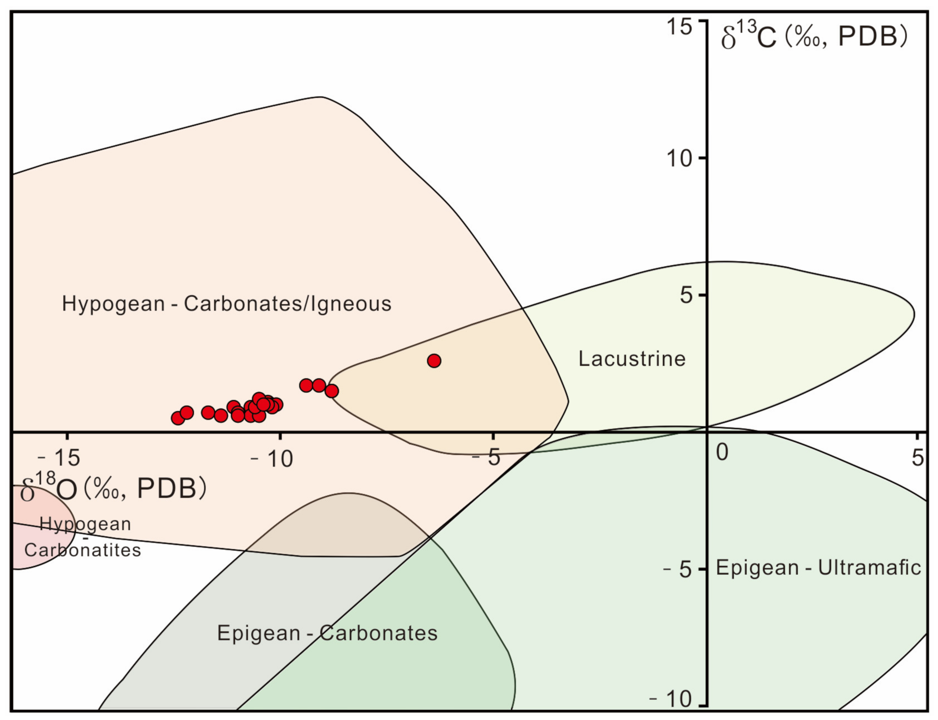
4.4. Carbon and Oxygen Isotopes
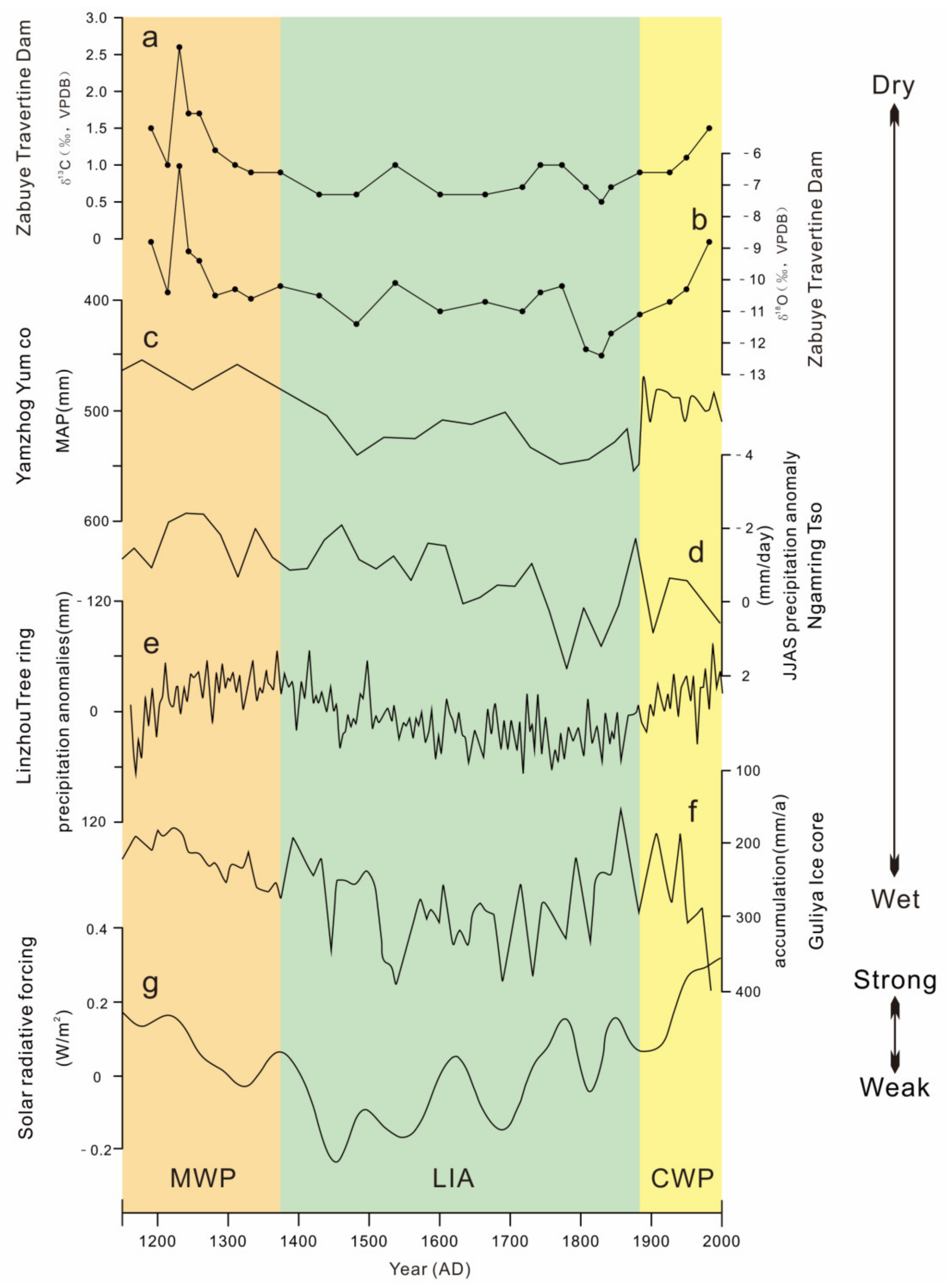
5. Discussion
5.1. Paleoclimatic Implications
5.2. Precipitation Changes at Zabuye Salt Lake over the Past 800 Years

6. Conclusions
Author Contributions
Funding
Data Availability Statement
Acknowledgments
Conflicts of Interest
References
- Qiu, J. China: The third pole. Nature 2008, 454, 393–396. [Google Scholar] [PubMed] [Green Version]
- Yao, T.; Thompson, L.G.; Mosbrugger, V.; Zhang, F.; Ma, Y.; Luo, T.; Xu, B.; Yang, X.; Joswiak, D.R.; Wang, W.; et al. Third Pole Environment (TPE). Environ. Dev. 2012, 3, 52–64. [Google Scholar]
- Liu, X.; Zheng, H.; Zhang, M.; Liu, C. Identification of dominant climate factor for pan evaporation trend in the Tibetan Plateau. J. Geogr. Sci. 2011, 21, 594–608. [Google Scholar]
- Flantua, S.; Henry, H.; Vuille, M.; Carson, J.; Gosling, W.; Hoyos, I.; Ledru, M.-P.; Montoya, E.; Mayle, F.; Maldonado, A.; et al. Climate variability and human impact in South America during the last 2000 years: Synthesis and perspectives from pollen records. Clim. Past 2016, 12, 483–523. [Google Scholar]
- Shao, X.; Xu, Y.; Yin, Z.Y.; Liang, E.; Zhu, H.; Wang, S. Climatic implications of a 3585-year tree-ring width chronology from the northeastern Qinghai-Tibetan Plateau. Quat. Sci. Rev. 2010, 29, 2111–2122. [Google Scholar] [CrossRef]
- Yang, B.; Qin, C.; Wang, J.; He, M.; Melvin, T.M.; Osborn, T.J.; Briffa, K.R. A 3500-year tree-ring record of annual precipitation on the northeastern Tibetan Plateau. Proc. Natl. Acad. Sci. USA 2014, 111, 2903–2908. [Google Scholar]
- He, M.; Yang, B.; Wang, J.; Wang, Z. Tree-ring-derived millennial precipitation record for the southern Tibetan Plateau and its possible driving mechanism. Holocene 2013, 23, 36–45. [Google Scholar]
- Grießinger, J.; Bräuning, A.; Helle, G.; Thomas, A.; Schleser, G. Late Holocene Asian summer monsoon variability reflected by δ18O in tree-rings from Tibetan junipers. Geophys. Res. Lett. 2011, 38, L03701. [Google Scholar] [CrossRef]
- Yao, T.; Duan, K.; Xu, B.; Wang, N.; Guo, X.; Yang, X. Precipitation record since AD 1600 from ice cores on the central Tibetan Plateau. Clim. Past 2008, 4, 175–180. [Google Scholar]
- Pang, H.; Hou, S.; Zhang, W.; Wu, S.; Jenk, T.M.; Schwikowski, M.; Jouzel, J. Temperature Trends in the Northwestern Tibetan Plateau Constrained by Ice Core Water Isotopes Over the Past 7000 Years. J. Geophys. Res. Atmos. 2020, 125, e2020JD032560. [Google Scholar]
- Guo, C.; Ma, Y.; Meng, H.; Hu, C.; Li, D.; Liu, J.; Luo, C.; Wang, K. Changes in vegetation and environment in Yamzhog Yumco Lake on the southern Tibetan Plateau over past 2000 years. Palaeogeogr. Palaeoclim. Palaeoecol. 2018, 501, 30–44. [Google Scholar] [CrossRef]
- He, Y.; Zhao, C.; Wang, Z.; Wang, H.; Song, M.; Liu, W.; Liu, Z. Late Holocene coupled moisture and temperature changes on the northern Tibetan Plateau. Quat. Sci. Rev. 2013, 80, 47–57. [Google Scholar]
- Conroy, J.L.; Hudson, A.M.; Overpeck, J.T.; Liu, K.-B.; Wang, L.; Cole, J.E. The primacy of multidecadal to centennial variability over late-Holocene forced change of the Asian Monsoon on the southern Tibetan Plateau. Earth Planet. Sci. Lett. 2017, 458, 337–348. [Google Scholar]
- Li, X.; Liang, J.; Hou, J.; Zhang, W. Centennial-scale climate variability during the past 2000 years on the central Tibetan Plateau. Holocene 2015, 25, 892–899. [Google Scholar] [CrossRef]
- Ji, K.; Zhu, E.; Chu, G.; Aquino-López, M.A.; Hou, J. A record of late Holocene precipitation on the Central Tibetan Plateau inferred from varved lake sediments. J. Paleolimnol. 2021, 66, 439–452. [Google Scholar] [CrossRef]
- Hou, J.; D’Andrea, W.J.; Liu, Z. The influence of 14C reservoir age on interpretation of paleolimnological records from the Tibetan Plateau. Quat. Sci. Rev. 2012, 48, 67–79. [Google Scholar]
- Wang, Z.; Yin, J.-J.; Cheng, H.; Ning, Y.; Meyer, M.C. Climatic controls on travertine deposition in southern Tibet during the late Quaternary. Palaeogeogr. Palaeoclim. Palaeoecol. 2022, 589, 110852. [Google Scholar] [CrossRef]
- Viles, H.A.; Tufas, A.G. Travertines and allied carbonate deposits. Prog. Phys. Geogr. 1990, 14, 19–41. [Google Scholar] [CrossRef]
- Ford, T.; Pedley, H. A review of tufa and travertine deposits of the world. Earth-Sci. Rev. 1996, 41, 117–175. [Google Scholar]
- Pentecost, A.; Viles, H. A Review and Reassessment of Travertine Classification. Geogr. Phys. Quat. 1994, 48, 305–314. [Google Scholar]
- Capezzuoli, E.; Gandin, A.; Pedley, M. Decoding tufa and travertine (fresh water carbonates) in the sedimentary record: The state of the art. Sedimentology 2014, 61, 1–21. [Google Scholar]
- Pentecost, A. The quaternary travertine deposits of Europe and Asia Minor. Quat. Sci. Rev. 1995, 14, 1005–1028. [Google Scholar]
- Agliasacchi, E.; Kayseri-Özer, M.S. Multidisciplinary approach for palaeoclimatic signals of the non-marine carbonates: The case of the Sarıkavak tufa deposits (Afyon, SW-Turkey). Quat. Int. 2019, 544, 41–56. [Google Scholar]
- Andrews, J.E.; Brasier, A. Seasonal records of climatic change in annually laminated tufas: Short review and future prospects. J. Quat. Sci. 2005, 20, 411–421. [Google Scholar]
- Andrews, J. Palaeoclimatic records from stable isotopes in riverine tufas: Synthesis and review. Earth-Sci. Rev. 2006, 75, 85–104. [Google Scholar]
- Kano, A.; Kawai, T.; Matsuoka, J.; Ihara, T. High-resolution records of rainfall events from clay bands in tufa. Geology 2004, 32, 793. [Google Scholar]
- Toker, E.; Kayseri-Özer, M.S.; Özkul, M.; Kele, S.; Ariztegui, D. Depositional system and palaeoclimatic interpretations of Middle to Late Pleistocene travertines: Kocabaş, Denizli, south-west Turkey. Sedimentology 2015, 62, 1360–1383. [Google Scholar]
- De Filippis, L.; Faccenna, C.; Billi, A.; Anzalone, E.; Brilli, M.; Soligo, M.; Tuccimei, P. Plateau versus fissure ridge travertines from Quaternary geothermal springs of Italy and Turkey: Interactions and feedbacks between fluid discharge, paleoclimate, and tectonics. Earth-Sci. Rev. 2013, 123, 35–52. [Google Scholar]
- Rodríguez-Berriguete, Á.; Alonso-Zarza, A.M.; Martín-García, R.; Cabrera, M.d.C. Sedimentology and geochemistry of a human-induced tufa deposit: Implications for palaeoclimatic research. Sedimentology 2018, 65, 2253–2277. [Google Scholar]
- Faccenna, C.; Soligo, M.; Billi, A.; De Filippis, L.; Funiciello, R.; Rossetti, C.; Tuccimei, P. Late Pleistocene depositional cycles of the Lapis Tiburtinus travertine (Tivoli, Central Italy): Possible influence of climate and fault activity. Glob. Planet. Chang. 2008, 63, 299–308. [Google Scholar]
- Ricketts, J.W.; Ma, L.; Wagler, A.E.; Garcia, V.H. Global travertine deposition modulated by oscillations in climate. J. Quat. Sci. 2019, 34, 558–568. [Google Scholar]
- Su, J.; Tan, H.; Chen, X. The groundwater deep circulation and large-scale geothermal deposition in response to the extension of the Yadong–Gulu rift, South Tibet, China. J. Volcanol. Geotherm. Res. 2020, 395, 106836. [Google Scholar]
- Wang, Z.; Meyer, M.C.; Hoffmann, D.L. Sedimentology, petrography and early diagenesis of a travertine–colluvium succession from Chusang (southern Tibet). Sediment. Geol. 2016, 342, 218–236. [Google Scholar]
- Wang, Z.; Meyer, M.C.; Gliganic, L.A.; Hoffmann, D.L.; May, J.-H. Timing of fluvial terrace formation and concomitant travertine deposition in the upper Sutlej River (Tirthapuri, southwestern Tibet) and paleoclimatic implications. Quat. Sci. Rev. 2017, 169, 357–377. [Google Scholar]
- Zentmyer, R.; Myrow, P.M.; Newell, D.L. Travertine deposits from along the South Tibetan Fault System near Nyalam, Tibet. Geol. Mag. 2008, 145, 753–765. [Google Scholar]
- Gao, J.; Zhou, X.; Fang, B.; Li, T.; Tang, L. U-series dating of the travertine depositing near the Rongma hot springs in northern Tibet, China, and its paleoclimatic implication. Quat. Int. 2012, 298, 98–106. [Google Scholar]
- Wang, Z.J.; Yin, J.; Yuan, D.X. Possibilities and problems associated with travertines and tufas in Quaternary studies: A case of the Tibetan Plateau. Chin. Sci. Bull. 2018, 63, 1012–1023, (In Chinese with English Abstract). [Google Scholar]
- Hammer, Ø.; Dysthe, D.K.; Jamtveit, B. The dynamics of travertine dams. Earth Planet. Sci. Lett. 2007, 256, 258–263. [Google Scholar]
- Pentecost, A.; Travertine, A. (Eds.) Pentecost; Springer: Dordrecht, The Netherlands, 2005; p. 446. [Google Scholar]
- Ding, T.; Zheng, M.; Nie, Z.; Ma, L.; Ye, C.; Wu, Q.; Zhao, Y.; Yang, D.; Wang, K. Impact of Regional Climate Change on the Development of Lithium Resources in Zabuye Salt Lake, Tibet. Front. Earth Sci. 2022, 10, 865158. [Google Scholar]
- Thompson, L.G.; Mosley-Thompson, E.; Davis, M.E.; Lin, P.N.; Dai, J.; Bolzan, J.F.; Yao, T. A 1000 year climate ice-core record from the Guliya ice cap, China: Its relationship to global climate variability. Ann. Glaciol. 1995, 21, 175–181. [Google Scholar]
- Liu, X.F.; Zheng, M.P.; Qi, W. Sources of Ore-Forming Materials of the Superlarge B and Li Deposit in Zabuye Salt Lake, Tibet, China. Acta Geol. Sin. 2007, 81, 1709–1715, (In Chinese with English Abstract). [Google Scholar]
- Zheng, M.P.; Xiang, J.; Wei, X.J.; Zheng, Y. Saline Lake on the Qinghai-Xizang (Tibet) Plateau; Science Press: Beijing, China, 1989; pp. 1–431, (In Chinese with English Abstract). [Google Scholar]
- Cheng, H.; Lawrence Edwards, R.; Shen, C.-C.; Polyak, V.J.; Asmerom, Y.; Woodhead, J.; Hellstrom, J.; Wang, Y.; Kong, X.; Spötl, C.; et al. Improvements in 230Th dating, 230Th and 234U half-life values, and U–Th isotopic measurements by multi-collector inductively coupled plasma mass spectrometry. Earth Planet. Sci. Lett. 2013, 371–372, 82–91. [Google Scholar]
- Edwards, R.L.; Chen, J.; Wasserburg, G. 238U234U230Th232Th systematics and the precise measurement of time over the past 500,000 years. Earth Planet. Sci. Lett. 1987, 81, 175–192. [Google Scholar]
- Lumsden, D.N. Discrepancy Between Thin-Section and X-Ray Estimates of Dolomite in Limestone. J. Sediment. Res. 1979, 49, 429–435. [Google Scholar]
- Goldsmith, J.R.; Graf, D.L.; Chodos, A.A.; Joensuu, O.I.; McVicker, L.D. Relation between lattice constants and composition of Ca-Mg carbonates. Am. Mineral. 1958, 43, 84–101. [Google Scholar]
- Haese, R.R.; Smith, J.; Weber, R.; Trafford, J. High-Magnesium Calcite Dissolution in Tropical Continental Shelf Sediments Controlled by Ocean Acidification. Environ. Sci. Technol. 2014, 48, 8522–8528. [Google Scholar]
- Auler, A.S.; Smart, P.L. Late Quaternary Paleoclimate in Semiarid Northeastern Brazil from U-Series Dating of Travertine and Water-Table Speleothems. Quat. Res. 2001, 55, 159–167. [Google Scholar]
- Martínez-Aguirre, A.; Alcaraz-Pelegrina, J.M.; Rodríguez-Vidal, J. U/Th dating of impure carbonates: 230Th/232Th activity ratios in detrital material. J. Radioanal. Nucl. Chem. Artic. 2019, 321, 71–81. [Google Scholar]
- Guo, L.; Riding, R. Hot-spring travertine facies and sequences, Late Pleistocene, Rapolano Terme, Italy. Sedimentology 1998, 45, 163–180. [Google Scholar]
- Craig, H. Isotopic Variations in Meteoric Waters. Science 1961, 133, 1702–1703. [Google Scholar]
- Craig, H. Standard for Reporting Concentrations of Deuterium and Oxygen-18 in Natural Waters. Science 1961, 133, 1833–1834. [Google Scholar] [PubMed]
- Panichi, C.; Tongiorgi, E. Carbon isotopic composition of CO2 from springs, fumaroles, mofettes and travertines of central and southern Italy: A preliminary prospection method of geothermal areas. In Proceedings of the 2nd U.N. Symposium on the Development and Use of Geothermal Energy, San Francisco, CA, USA, 20–29 May 1975. [Google Scholar]
- Kohn Matthew, J. Carbon isotope compositions of terrestrial C3 plants as indicators of (paleo)ecology and (paleo)climate. Proc. Natl. Acad. Sci. USA 2010, 107, 19691–19695. [Google Scholar]
- Wang, G.; Feng, X.; Han, J.; Lp, Z.; Wb, T.; Su, F. Paleovegetation reconstruction using δ13C of Soil Organic Matter. Biogeosciences 2008, 5, 1325–1337. [Google Scholar]
- Minissale, A.; Kerrick, D.M.; Magro, G.; Murrell, M.T.; Paladini, M.; Rihs, S.; Sturchio, N.C.; Tassi, F.; Vaselli, O. Geochemistry of Quaternary travertines in the region north of Rome (Italy): Structural, hydrologic and paleoclimatic implications. Earth Planet. Sci. Lett. 2002, 203, 709–728. [Google Scholar]
- Hoefs, J. Stable Isotope Geochemistry; Springer: Berlin/Heidelberg, Germany, 1997; p. 201. [Google Scholar]
- Rollinson, H.R. Using Geochemical Data: Evaluation, Presentation, Interpretation. Mineralogical Magazine; Longman Scientific and Technical: London, UK, 1993; Volume 58, 352p. [Google Scholar]
- Teboul, P.A.; Durlet, C.; Gaucher, E.C.; Virgone, A.; Girard, J.P.; Curie, J.; Lopez, B.; Camoin, G.F. Origins of elements building travertine and tufa: New perspectives provided by isotopic and geochemical tracers. Sediment. Geol. 2016, 334, 97–114. [Google Scholar]
- Boom, A.; Mora, G.; Cleef, A.M.; Hooghiemstra, H. High altitude C4 grasslands in the northern Andes: Relicts from glacial conditions? Rev. Palaeobot. Palynol. 2001, 115, 147–160. [Google Scholar]
- Rodrigo-Naharro, J.; Herrero, M.J.; Delgado-Huertas, A.; Granados, A.; Pérez del Villar, L. Current travertines precipitation related to artificial CO2 leakages from a natural reservoir (Gañuelas-Mazarrón Tertiary Basin, SE Spain). J. Hydrol. 2019, 577, 123997. [Google Scholar]
- Mancini, A.; Frondini, F.; Capezzuoli, E.; Mejia, E.G.; Lezzi, G.; Matarazzi, D.; Brogi, A.; Swennen, R. Evaluating the geogenic CO2 flux from geothermal areas by analysing quaternary travertine masses. New data from western central Italy and review of previous CO2 flux data. Quat. Sci. Rev. 2019, 215, 132–143. [Google Scholar]
- Kokh, S.N.; Shnyukov, Y.F.; Sokol, E.V.; Novikova, S.A.; Kozmenko, O.A.; Semenova, D.V.; Rybak, E.N. Heavy carbon travertine related to methane generation: A case study of the Big Tarkhan cold spring, Kerch Peninsula, Crimea. Sediment. Geol. 2015, 325, 26–40. [Google Scholar]
- Fang, B.; Yang, Y.J.; Wang, G.H.; Zhou, X.; Chen, S.N. Characteristics and resource evaluation of the Jiwa geothemal field in central Qiangtang, northern Tibet, China. Geol. Bull. China 2009, 28, 1335–1341, (In Chinese with English Abstract). [Google Scholar]
- Zhou, L. Characteristics of the Typical Hot Springs in the Central Tibet. Master’s Thesis, China University of Geosciences (Beijing), Beijing, China, 2012. (In Chinese with English Abstract). [Google Scholar]
- Chen, C.J. Provenance Analysis of Xiqin Geothermal Field, in Lazi County, Tibet. Master’s Thesis, Hebei GEO University, Shijiazhuang, China, 2019. [Google Scholar]
- Chevalier, M.L.; Tapponnier, P.; Woerd, J.; Leloup, P.H.; Wang, S.; Pan, J.; Bai, M.; Kali, E.; Liu, X.; Li, H. Late Quaternary Extension Rates Across the Northern Half of the Yadong-Gulu Rift: Implication for East-West Extension in Southern Tibet. J. Geophys. Res. Solid Earth 2020, 125, e2019JB019106. [Google Scholar]
- Liu, Z.; Li, H.; You, C.; Wan, N.; Sun, H. Thickness and stable isotopic characteristics of modern seasonal climate-controlled sub-annual travertine laminas in a travertine-depositing stream at Baishuitai, SW China: Implications for paleoclimate reconstruction. Environ. Earth Sci. 2006, 51, 257–265. [Google Scholar] [CrossRef]
- Prado-Pérez, A.J.; Delgado Huertas, A.; Crespo, M.; SÁNchez, A.; Villar, L. Late Pleistocene and Holocene mid-latitude palaeoclimatic and palaeoenvironmental reconstruction: An approach based on the isotopic record from a travertine formation in the Guadix-Baza basin, Spain. Geol. Mag. 2013, 150, 602–625. [Google Scholar]
- Yao, T.; Masson-Delmotte, V.; Gao, J.; Yu, W.; Yang, X.; Risi, C.; Sturm, C.; Werner, M.; Zhao, H.; He, Y.; et al. A review of climatic controls on δ18O in precipitation over the Tibetan Plateau: Observations and simulations. Rev. Geophys. 2013, 51, 525–548. [Google Scholar]
- Tian, L.; Yao, T.; Numaguti, A.; Sun, W. Stable Isotope Variations in Monsoon Precipitation on the Tibetan Plateau. J. Meteorol. Soc. Jpn. Ser. II 2001, 79, 959–966. [Google Scholar] [CrossRef] [Green Version]
- Yu, W.; Yao, T.; Tian, L.; Ma, Y.; Ichiyanagi, K.; Wang, Y.; Sun, W. Relationships between δ18O in precipitation and air temperature and moisture origin on a south–north transect of the Tibetan Plateau. Atmos. Res. 2008, 87, 158–169. [Google Scholar] [CrossRef]
- Feng, X.; Zhao, C.; D’Andrea, W.J.; Liang, J.; Zhou, A.; Shen, J. Temperature fluctuations during the Common Era in subtropical southwestern China inferred from brGDGTs in a remote alpine lake. Earth Planet. Sci. Lett. 2019, 510, 26–36. [Google Scholar]
- Ge, Q.; Hao, Z.; Zheng, J.; Shao, X. Temperature changes over the past 2000 yr in China and comparison with the Northern Hemisphere. Clim. Past 2013, 9, 1153–1160. [Google Scholar] [CrossRef] [Green Version]
- Bao, Y.; Braäuning, A.; Yafeng, S. Late Holocene temperature fluctuations on the Tibetan Plateau. Quat. Sci. Rev. 2003, 22, 2335–2344. [Google Scholar] [CrossRef]
- Li, X.; Zhang, Y.; Wang, M.; Yan, J.; Fan, B.; Xing, W.; He, Y.; Hou, J. Centennial-Scale Temperature Change During the Common Era Revealed by Quantitative Temperature Reconstructions on the Tibetan Plateau. Front. Earth Sci. 2020, 8, 360. [Google Scholar] [CrossRef]
- Zhang, X.L.; Xu, B.Q.; Li, J.L.; Xi, Y.; Gao, S.P.; Wang, M. Climatic and environmental changes over the past about 300 years recorded by lake sediments in Taro Co, southwestern Tibetan Plateau. J. Earth Sci. Environ. 2012, 34, 79–90, (In Chinese with English Abstract). [Google Scholar]
- Sheng, E.; Yu, K.; Xu, H.; Lan, J.; Liu, B.; Che, S. Late Holocene Indian summer monsoon precipitation history at Lake Lugu, northwestern Yunnan Province, southwestern China. Palaeogeogr. Palaeoclim. Palaeoecol. 2015, 438, 24–33. [Google Scholar] [CrossRef]
- Xu, H.; Zhou, X.; Lan, J.; Liu, B.; Sheng, E.; Yu, K.; Cheng, P.; Wu, F.; Hong, B.; Yeager, K.M.; et al. Late Holocene Indian summer monsoon variations recorded at Lake Erhai, Southwestern China. Quat. Res. 2015, 83, 307–314. [Google Scholar] [CrossRef]
- Fleitmann, D.; Burns Stephen, J.; Mudelsee, M.; Neff, U.; Kramers, J.; Mangini, A.; Matter, A. Holocene Forcing of the Indian Monsoon Recorded in a Stalagmite from Southern Oman. Science 2003, 300, 1737–1739. [Google Scholar] [CrossRef] [Green Version]
- Duan, K.; Yao, T.; Thompson, L.G. Low-frequency of southern Asian monsoon variability using a 295-year record from the Dasuopu ice core in the central Himalayas. Geophys. Res. Lett. 2004, 31, L16209. [Google Scholar] [CrossRef] [Green Version]
- Chu, G.; Sun, Q.; Yang, K.; Li, A.; Yu, X.; Xu, T.; Yan, F.; Wang, H.; Liu, M.; Wang, X.; et al. Evidence for decreasing South Asian summer monsoon in the past 160 years from varved sediment in Lake Xinluhai, Tibetan Plateau. J. Geophys. Res. Earth Surf. 2011, 116, D02116. [Google Scholar] [CrossRef] [Green Version]
- Xu, H.; Hong, Y.; Hong, B. Decreasing Indian summer monsoon intensity after 1860 AD in the global warming epoch. Clim. Dyn. 2012, 39, 2079–2088, Erratum in Clim. Dyn. 2012, 39, 2089. [Google Scholar] [CrossRef]
- Mann, M.; Cane, M.; Zebiak, S.; Clement, A. Volcanic and Solar Forcing of the Tropical Pacific over the Past 1000 Years. J. Clim. 2005, 18, 447–456. [Google Scholar] [CrossRef] [Green Version]
- Sun, Z.; Yuan, K.; Hou, X.; Ji, K.; Li, C.-G.; Wang, M.; Hou, J. Centennial-scale interplay between the Indian Summer Monsoon and the Westerlies revealed from Ngamring Co, southern Tibetan Plateau. Holocene 2020, 30, 1163–1173. [Google Scholar] [CrossRef]


| Sample | 238U | 232Th | 230Th/232Th | d234U | 230Th/238U | 230Th Age (yr) | 230Th Age (yr) | d234UInitial | 230Th Age (yr BP) |
|---|---|---|---|---|---|---|---|---|---|
| (ppb) | (ppt) | (Atomic × 10−6) | (Measured) | (Activity) | (Uncorrected) | (Corrected) | (Corrected) | (Corrected) | |
| ZD10 | 4518 ± 16 | 379,893 ± 7712 | 7.6 ± 0.2 | 748.8 ± 4.1 | 0.0389 ± 0.0003 | 2452 ± 17 | 304 ± 308 | 749 ± 4 | 283 ± 308 |
| ZD17 | 3660 ± 11 | 469,369 ± 9489 | 8.1 ± 0.2 | 751.9 ± 3.8 | 0.0628 ± 0.0004 | 3972 ± 25 | 689 ± 470 | 753 ± 4 | 668 ± 470 |
| ZD24 | 3759 ± 13 | 669,952 ± 13,565 | 7.9 ± 0.2 | 746.7 ± 3.9 | 0.0851 ± 0.0005 | 5430 ± 36 | 830 ± 660 | 748 ± 4 | 809 ± 660 |
| Sample | δDV-SMOW (‰) | δ18OV-SMOW (‰) |
|---|---|---|
| ZQ-01 | −132.9 | −14.5 |
| ZQ-02 | −136.6 | −15.9 |
| ZH-01 | −118.9 | −12.8 |
Publisher’s Note: MDPI stays neutral with regard to jurisdictional claims in published maps and institutional affiliations. |
© 2022 by the authors. Licensee MDPI, Basel, Switzerland. This article is an open access article distributed under the terms and conditions of the Creative Commons Attribution (CC BY) license (https://creativecommons.org/licenses/by/4.0/).
Share and Cite
Li, M.; Zheng, M.; Ye, C.; Wang, C.; Zhang, X.; Wang, X.; Zhao, Y.; Zhang, Y. Response of Travertine Dam to Precipitation over the Past 800 Years in Zabuye Salt Lake, Southwestern Tibetan Plateau. Minerals 2022, 12, 916. https://doi.org/10.3390/min12070916
Li M, Zheng M, Ye C, Wang C, Zhang X, Wang X, Zhao Y, Zhang Y. Response of Travertine Dam to Precipitation over the Past 800 Years in Zabuye Salt Lake, Southwestern Tibetan Plateau. Minerals. 2022; 12(7):916. https://doi.org/10.3390/min12070916
Chicago/Turabian StyleLi, Mingming, Mianping Zheng, Chuanyong Ye, Chenguang Wang, Xuefei Zhang, Xuefeng Wang, Yuanyi Zhao, and Yanbo Zhang. 2022. "Response of Travertine Dam to Precipitation over the Past 800 Years in Zabuye Salt Lake, Southwestern Tibetan Plateau" Minerals 12, no. 7: 916. https://doi.org/10.3390/min12070916